Article

Carbon Stock and CO2 Fluxes in Various Land Covers in Karang Gading and Langkat Timur Laut Wildlife Reserve, North Sumatra, Indonesia

1
Department of Forestry, Faculty of Forestry, Universitas Sumatra Utara, Jl. Tri Dharma Ujung No. 1 Kampus USU, Medan 20155, Indonesia
2
Center of Excellence for Mangrove, Universitas Sumatera Utara, Medan 20155, Indonesia
3
Environmental Research Institute, National University of Singapore (NUS), 21 Lower Kent Ridge Road, Singapore 119077, Singapore
4
Biotechnology and Tree Breeding Laboratory, Faculty of Forestry, Universitas Hasanuddin, Makassar 90245, Indonesia
5
School of Life Sciences and Technology, Institut Teknologi Bandung, Bandung 40132, Indonesia
6
Research Center for Ecology and Ethnobiology, National Research and Innovation Agency, Cibinong 16911, Indonesia
7
Department of Botany and Microbiology, College of Science, King Saud University, Riyadh 11451, Saudi Arabia
*
Author to whom correspondence should be addressed.
Sustainability 2023, 15(21), 15196; https://doi.org/10.3390/su152115196
Submission received: 18 July 2023 / Revised: 8 September 2023 / Accepted: 18 September 2023 / Published: 24 October 2023
(This article belongs to the Special Issue Land Use Change Effects on Tropical Forest Ecosystem)

Abstract

:
Mangrove forests play an important role in coastal areas from an ecological perspective, being able to store large amounts of carbon through sequestration and inhibiting climate change processes by absorbing CO2 in the atmosphere. In recent years, there have been changes in the land cover of converted and degraded mangrove forests which have resulted in the release of carbon and an imbalance in soil structure, which in turn cause a flux of CO2 into the atmosphere. This research was conducted at the Karang Gading and Langkat Timur Laut Wildlife Reserve (KGLTLWR) in North Sumatra, Indonesia. The study focused on six different land covers, namely natural forests, restoration, mixed agriculture, paddy fields, oil palm plantation, and ponds. This study aimed to measure the total carbon stock of mangrove forests that have been converted to other land covers and estimate the level of CO2 flux in the area. A total of three transects and six plots for each land cover were used in this study; for tree biomass, a non-destructive method was used by recording every DBH > 5 cm, and for soil carbon, drilling was carried out, which was divided into five depths in each plot. CO2 flux was measured using an Eosense Eosgp CO2 sensor with the static closed chamber method. The highest carbon stock was found at 308.09 Mg ha−1 in natural forest, while the lowest 3.22 Mg ha−1 was found in mixed agriculture. The highest soil carbon was found at 423.59 MgC ha−1 in natural forest, while the lowest 50.44 MgC ha−1 was found in mixed agriculture dry land. The highest average CO2 flux value of 1362.24 mgCO2 m2 h−1 was found in mangrove restoration and the lowest in ponds was 123.03 mgCO2 m2 h−1. Overall, the research results inform how much carbon stock is lost when converted to other land covers so that it can be used as a reference for policy makers to provide future management of mangrove forests and develop mitigation measurements to reduce carbon emissions.

1. Introduction

Mangrove forests function as carbon storage and serve as a mitigation process of climate change by absorbing CO2 in the atmosphere [1,2]. Karang Gading Langkat Timur Laut Wildlife Reserve (KGLTLWR) is a conservation area in the form of mangrove forest with an area of 15,765 ha, marine vegetation dominated by mangrove forest vegetation (more than 11,500 ha or 70% of the area), and a little green forest of at least 37 plant species from 21 families [3]. In recent years, there has been a change in mangrove forest land cover which has been converted, with an area of ±6558 ha in the form of oil palm plantations, fish ponds, permanent shrimp ponds, agriculture land, and community settlements which can result in carbon release and an imbalance in soil structure which in turn causes a flux of CO2 into the atmosphere [3,4].
Even though mangrove forests have the potential to store very large carbon reserves, they occupy only 0.5% of the global coastal area. Mangroves are able to store 1023 MgC ha−1 or three to five times more than other types of terrestrial forests [5]. When a hectare of forest (trees) disappears (dead trees), sooner or later the biomass stored in trees will decompose and the carbon elements bound to the air become emissions [6,7,8]. This change in carbon form then becomes the basis for calculating emissions [9,10].
The amount of CO2 gas emitted and absorbed in the atmosphere is considered uncertain. Therefore, it is necessary to analyze the CO2 transfer process by observing the CO2 flux. CO2 flux is the amount of CO2 gas flowing through the sea surface either from air into the water or from water into the air per a certain area per unit time. The CO2 solubility function and the CO2 gas transfer rate that occur at sea level are referred to as the CO2 flux [11,12]. Soil CO2 flux is the release of CO2 gas produced by the respiration of autotrophs (plant roots) and heterotrophs (soil microbes and fauna). CO2 flux serves as an indicator of the overall production and metabolic activity of living organisms in the soil [13]. The decomposition of soil organic matter can lead to an increase in CO2 flux into the atmosphere. The two biggest contributors to greenhouse gas emissions today are carbon dioxide (CO2) and methane (CH4). The main contributors to these emissions are the energy systems sector (34%), industry (24%), AFOLU (agriculture, forestry, and other land uses) (21%), transportation (14%), and building operations (6%) [3,14]. The average carbon stock in Indonesian mangroves is 950.5 Mg C ha−1 [15]. Mangroves in the study areas in Serang (sand mining location) and Angke (adjacent to the deposition location) are estimated to store an average of 203.64 Mg C ha−1 and 531.53 Mg C ha−1, respectively [16]. Peak GHG fluxes were observed in rehabilitation (32.8 ± 2.1 MgCO2 ha−1y−1) and undisturbed (43.8 ± 4.5 MgCO2 ha−1y) sites as well as dry open aquaculture ponds (30.6± 1.9 MgCO2 ha−1y−1) [17].
Changes in land use can affect soil structure. Therefore, it is necessary to analyze land cover change and its impact on CO2 flux. Research on the impact of changes in land cover in the North Sumatra KGLTLWR is important for planning and implementing coastal management. This study aims to develop a systematic approach to inform how much carbon stock is lost when converted to other land covers, which is then linked to the resulting CO2 flux value and integrated with land use for an effective emission reduction plan.

2. Materials and Methods
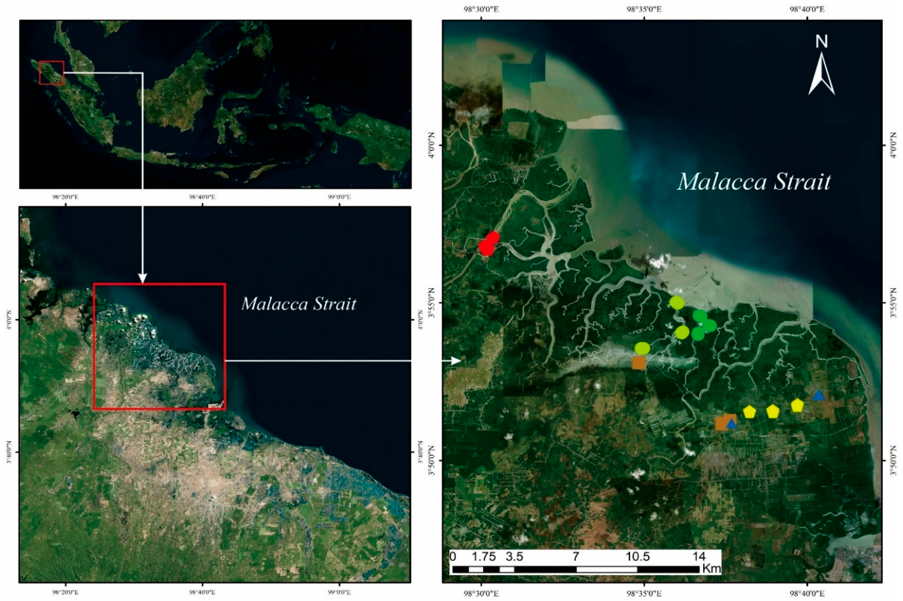
2.1. Materials

This research began in December 2021 at the Karang Gading and Langkat Timur Laut Wildlife Reserve (KGLTLWR), located in the districts of Hamparan Perak and Labuhan Deli, Deli Serdang Regency, and Secanggang and Tanjung Pura districts, Langkat Regency (Figure 1). KGLTLWR is a conservation area consisting of mangrove and coastal forests with flat topography (0–8%), a land elevation of up to 5 m asl, and partly a tidal area [3]. Rainfall ranges from 2010 to 2327 mm/year. Between December and March, northeasterly winds bring dry air and rainfall is generally low (below 100 mm/month in months February and March). From March to September the area is under the influence of the northwestern monsoon, heavy rainfall occurs in May, and August to October has an average temperature of 28–36 °C [3]. The soil in the mangrove forest is dominated by clay, which in several locations is mixed with gravel, fine sand, organic matter, and carbonate bioclastic (especially shell fragments) [3].
The data were analyzed by R and RStudio program. An Eosense Eosgp CO2 sensor was used to measure CO2 fluxes (Figure 2).

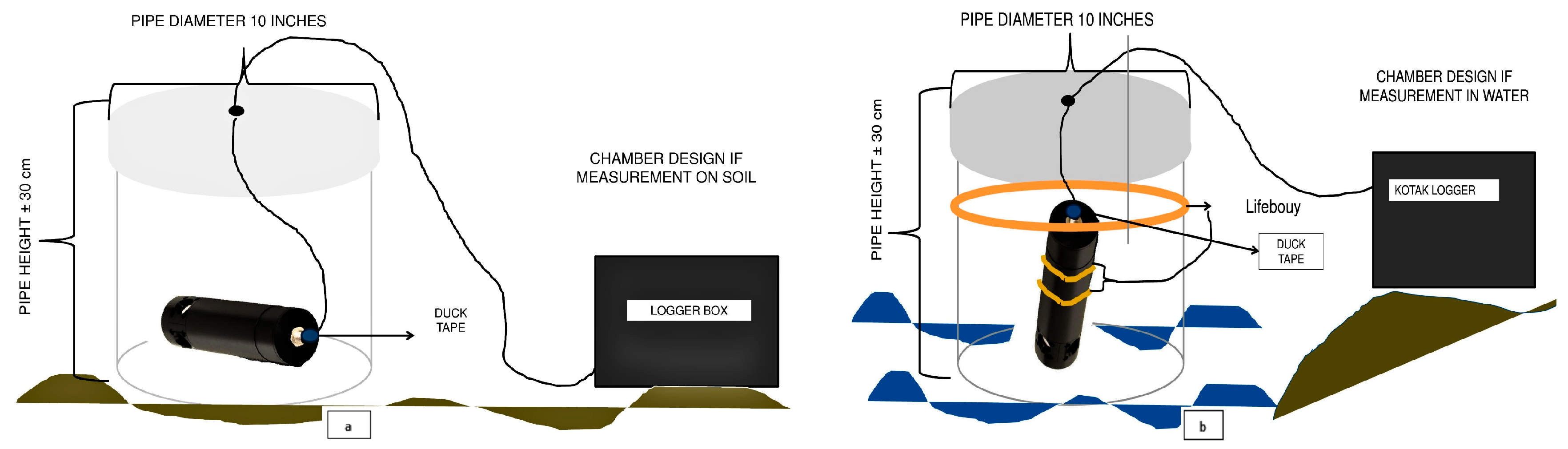
2.2. Soil Sampling and Biomass Assessment

Soil sampling for organic carbon content was carried out by collecting sub-samples of 5 cm from the midpoint in each five-depth range, namely at depths of 0–15 cm, 20–30 cm, 30–50 cm, 50–100 cm, and 100–200 cm using a Russian peat corer (Figure 2, [7]). Soil samples were carefully dried at 70 °C until they reached a constant weight and grounded before being sent to the laboratory for organic carbon concentration analysis. Soil carbon stock is the product of bulk density, soil depth, and carbon content. Measurement of the tree biomass was performed non-destructively using the 2019–2022 tree census dataset (planted mangrove at 4, 5, and 7 years old, respectively). We only included trees with a DBH of 5 cm for the total biomass estimation (Table 1, [18]).
Carbon stock estimation in oil palm plantations was calculated using the formula initiated by Dewi [19], where with H (tree height) and p (density) for stem biomass:
AGB = (0.0976 * H) + 0.0706
The calculation of carbon stock in mixed agriculture dry land uses the formula referring to Kettering [20], namely:
Biomassa: 0.11p DBH2.62
Table 1. Allometric equations for calculating mangrove tree biomass used in this study [18].
Above-Ground Biomass (kg)Below-Ground Biomass (kg)
A. marinaA. marina
   Wtop = 0.308DBH2.11, r2 = 0.97, n = 22,    WR = 1.28DBH 1.17, r2 = 0.80, n = 14,
   Dmax = 35 cm [21]   Dmax = 35 cm, [21]
Rhizophora spp.
   Wtop = 0.128DBH2.60, r2 = 0.92, n = 9,
   Dmax = 32 cm [22]
   Wtop = 0.105DBH2.68, r2 = 0.99, n = 23,
   Dmax = 25 cm [23]
Rhizophora apiculata
   Wtop = 0.235DBH2.42, r2 = 0.98, n = 57,
   Dmax = 28 cm [22]
Bruguiera gymnorrhiza
   Wtop = 0.186DBH2.31, r2 = 0.99, n = 17,
   Dmax = 25 cm [23]
Bruguiera gymnorrhiza
   Wtop = 0.186DBH2.31, r2 = 0.99, n = 17,
   Dmax = 25 cm [23]
Bruguiera parviflora
   Wtop = 0.168DBH2.42, r2 = 0.99,
   Dmax = 25 cm, n = 16 [23]
Xylocarpus grnatum
   Wtop = 0.0823DBH2.59, r2 = 0.99, n = 15,
   Dmax = 25 cm [23]
Common equation:
   Wtop = 0.251 pD2.46, r2 = 0.98, n = 104,
   Dmax = 49 cm [24]
Bruguiera spp.
   WR = 0.0188 (D2H)0.909, n = 11, Dmax = 33 cm cf, H = D/(0.025D + 0.583) [25]
R. apiculata
   WR = 0,00698DBH2.61, r2 = 0.99, n = 11, Dmax = 28 cm [22]
R. stylosa
   WR = 0.261DBH1.86, r2 = 0.92, n = 5, Dmax = 15 cm [25]
Rhizophora spp.
   WR = 0.00974 (D2H)1.05, r2: undefined, n = 16, D max = 40 cm [22]
Xylocarpus granatum
   WR = 0.145DBH2.55, r2 = 0.99, n = 6,
   Dmax = 8 cm [26]
Bruguiera exaristata
   WR = 0.302DBH2.15, r2 = 0.88, n = 9,
   Dmax = 10 cm [21]
Common equation:
   WR = 0.199 p 0.899 D2.22, r2 = 0.95, n =26, Dmax = 45 cm [24]

2.3. CO2 Flux Calculation

CO2 flux sampling was performed using two devices, a CR1000x logger chamber (Campbell Scientific, Logan, UT, USA) and an Eosense Eosgp CO2 sensor (Eosense, Dartmouth, NS, Canada), by enclosing the chamber on mangrove ecosystem land and water, as displayed in Figure 3. Chambers were randomly placed at each mangrove station with up to 3 points and 3 replications. Then, a gas sample was taken inside the chamber using an Eosense sensor. The chamber serves to measure the accumulation of CO2 flux. It was closed for 3 min, followed by 2 min with the chamber lid open. This method was repeated three times during the measurement time. The data obtained were monitored on a desktop using the PC1000 application.

2.4. Data Analysis

Data measurements were processed and analyzed statistically using software applications such as R version 4.1.3, RStudio version 4.2.3, IBM SPSS v26, and Microsoft Excel 2013 The following equation [27,28] was used for this analysis:
F = S C O 2 . V R · T a i r   c h a m b e r · A
where F = ground-air CO2 flux (mmol m−2 s−1);
SCO2 = slope of CO2 in the chamber over time (atm−1 s);
V = total volume of the flux chamber + tube (m3);
R = ideal gas constant (atm m3 K−1 mol−1);
Tair chamber = absolute air temperature in the chamber (K); and
A = ground surface covered by the chamber (m2).
The slope was calculated using linear regression. Only regressions with an R2 value of 0.7 and p < 0.05 were saved to calculate F. When taking measurements, it is important to consider environmental variables such as air temperature and the number of macrozoobenthos.

2.5. Analysis of CO2 Flux in Different Land Cover Types

The results of the CO2 flux calculations were analyzed using descriptive statistical analysis and a one-way ANOVA test at a 95% confidence level. CO2 flux was compared among different land cover types, such as ponds, oil palm plantations, natural mangrove forests, mangrove forest restoration, mixed agriculture, and rice fields [29].

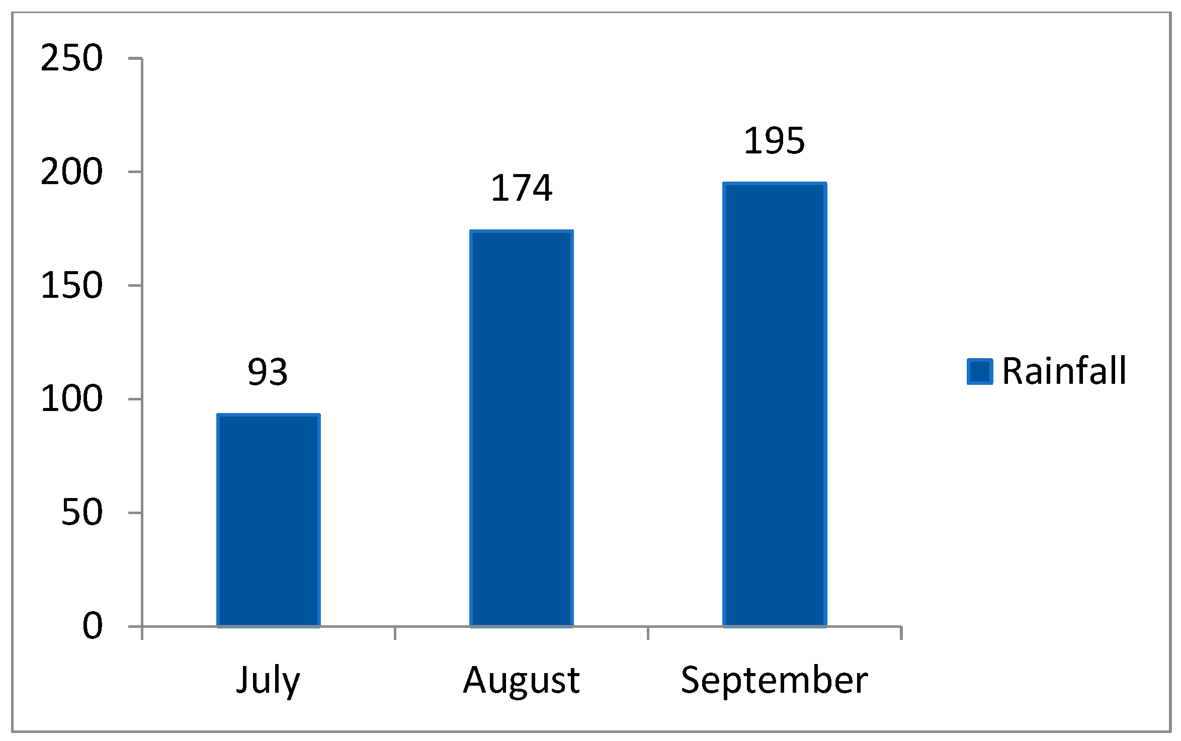
2.5.1. Analysis of CO2 Flux in Rainy and Dry Seasons

The mean difference test, specifically the paired sample t-test, was used to compare the CO2 flux between the dry season and the rainy season.

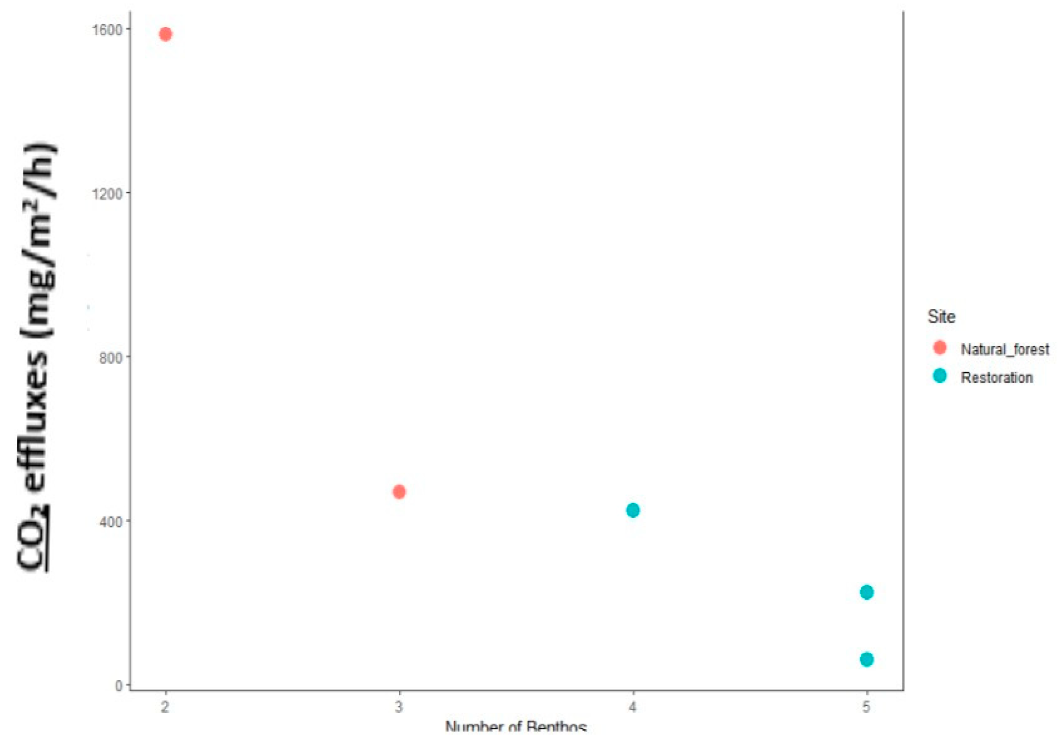
2.5.2. Analysis of the Relationship of Macrozoobenthos with CO2 Flux

Correlation analysis was used to determine the relationship between macrozoobenthos and CO2 flux. Macrozoobenthos data were collected in natural mangrove forests and restored mangroves during the rainy season (September 2022) and dry season (July–August 2022).

3. Results

3.1. Standing Structure

There are nine types of true mangroves and 23 associated mangrove species. The highest number of individuals found in the mangrove forest of North Sumatra KGLTLWR was 1787 ind/ha for natural forest, followed by restored mangrove at 1.762 ind/ha, oil palm at 155 ind/ha, and agriculture dry land at 134 ind/ha (Table 2).

3.2. Standing Structure, Average Diameter, and Basal Area

The highest average diameter values are found in natural forests, followed by restored forests, mixed agriculture dry land, and oil palm. The highest basal area values are found in natural forests, followed by mixed agriculture dry land, restored forests, and oil palm plantations. This is because the natural forest is typically characterized by dense vegetation and minimal human interference, resulting in a more intact stand structure, greater height and basal area, and better overall quality compared to other land cover types. The values for the stand structure, average diameter, and basal area are shown in Table 3.

3.3. Vegetation and Soil Carbon Stocks in Mangrove Forests and Various Land Covers

Carbon stocks in vegetation are generally influenced by the amount of carbon contained in above-ground biomass. The value of carbon stocks in mangrove forests and various vegetated land cover in KGLTLWR in North Sumatra is shown in Table 4. Specifically for oil palm and agriculture dry land, we only calculated above-ground biomass according to the allometric used, namely Dewi et al. (2009) [19] and Kettering et al. (2001) [20]. In paddy fields and ponds, we only collected soil carbon data due to the absence of woody vegetation.
Table 4 shows that the highest carbon stock was found in natural forests (716.09 MgC ha−1), while the lowest carbon stock was obtained in mixed agriculture forest areas (57.45 MgC ha−1). This research found that the total carbon stock in oil palm plantations was 79.07 MgC ha−1. This result is much higher than the findings of previous research conducted by Basyuni et al. on oil palm plantations in the KGLTLWR, North Sumatra, namely 22.96 MgC ha−1 [4]. The highest soil carbon stock was found in natural forests, with an average value of 423.59 MgC ha−1, while the lowest was found in mixed agriculture land cover, with an average of 50.44 MgC ha−1 (Table 4). In this study, it was seen that there was a significant reduction in carbon stock of up to 50% if its function was transferred to other uses. In this study, natural mangrove forests for mixed agriculture will reduce carbon stock by up to 80%.

3.4. Content of CO2 Flux Values in Various Land Covers

The average flux of CO2 in mangrove natural forest land cover was found to be 1297 mg CO2 m2 h−1 during the rainy season and 835 mg CO2 m2 h−1 during the dry season (Figure 4). CO2 flux in restored land cover during the rainy season was found to be an average of 1635 mg CO2 m2 h−1, while in the dry season, it was 1321 mg CO2 m−2 h−1.

3.5. Analysis of the Effect of CO2 Flux on Various Land Covers

A paired mean difference test (comparing means) was carried out through a paired sample t-test. Analysis of the effect of mangrove CO2 flux was conducted using a paired sample t-test to compare means, as shown in Table 5.
Table 5 indicates that the t-tests show that there was no difference in the average amount of CO2 flux between the dry and rainy seasons in primary forests (Table 5). Similarly, there was no difference in the average amount of CO2 flux between the dry and rainy seasons in restoration forests, mixed agriculture, rain ponds, and oil palm plantations. However, there was a difference in the average CO2 flux between the dry season and the rainy season in rice fields (0.03 < 0.05). During the study period, the rainfall varied between the dry season (July–August) and the rainy season (September), as shown in Figure 5.

3.6. Correlation Analysis of Macrozoobenthos with CO2 Flux

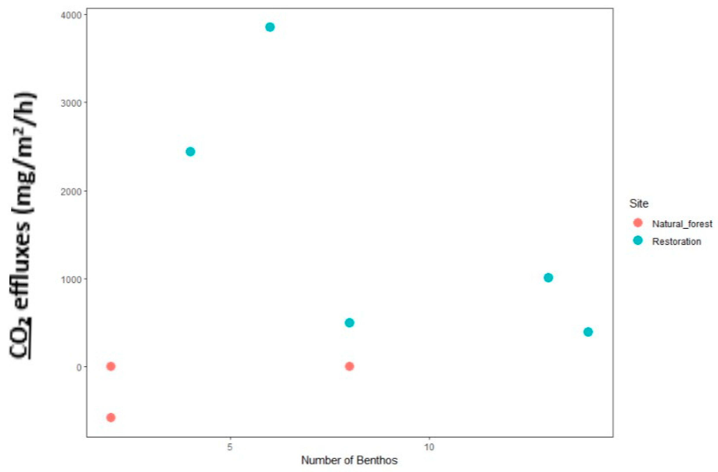
3.6.1. Number of Macrozoobenthos Holes and Their Impact on CO2 Flux Rate

Macrozoobenthos increase oxygen levels in the sediment or substrate by creating holes in the substrate through bioturbation. From this report, it can be inferred that an increase in the number of macrozoobenthos holes leads to a higher population of macrozoobenthos. Consequently, there is a greater reliance on the substrate contained in the soil, resulting in a decrease in the amount of carbon stored in the soil.
Figure 6 shows that the average value of CO2 flux in the land cover of natural mangrove forests and restoration forests during the rainy season is 551.29 mgCO2 m2 h−1, with a total of 19 benthic holes. As per Figure 7 during the dry season, the average number of benthic holes increased to 59, with a CO2 flux of 843.324 mgCO2 m2 h−1.
Based on the test results in Table 6, the significance value of the Pearson correlation test was obtained as 0.815 (>5% or 0.05). This indicates that there is no significant relationship between the number of holes in macrozoobenthos and CO2 flux. The results also showed that the correlation coefficient (r) between the number of macrozoobenthos holes and CO2 flux was 0.815. It suggests that there is no significant relationship between the number of benthos and the value of CO2 flux (Table 6). The results of the correlation test between the number of macrozoobenthos and CO2 flux are shown in Table 6.

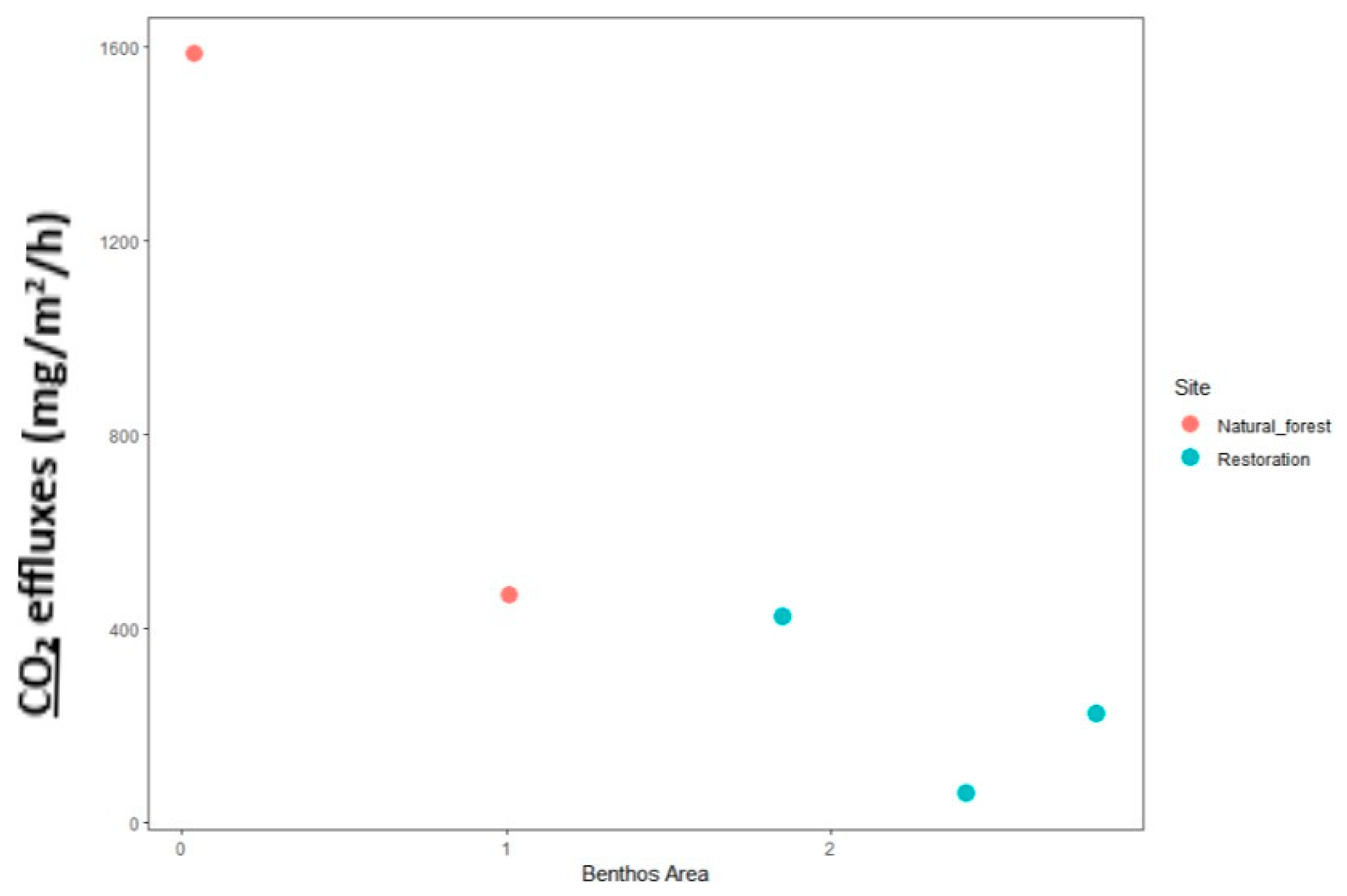
3.6.2. Macrozoobenthos and Their Impact on CO2 Flux Levels in a Given Area

The average area of benthic holes in the rainy season was 8.1404 cm2, as shown in Figure 8. In contrast, during the dry season, the average area of benthic holes was 12,905 cm2, as indicated in Figure 9.
Based on the test results shown in Table 7, it is evident that there is no significant relationship between the area of macrozoobenthos holes and CO2 flux. The results also showed that the correlation coefficient (r) between the area of macrozoobenthos holes and CO2 flux is −0.185. It shows that there is an inverse relationship between the area of macrozoobenthos holes and CO2 flux. This means that if the area of macrozoobenthos holes is small, the CO2 flux will be high, and vice versa. Correlation test results between the area of the macrozoobenthos hole and CO2 flux are shown in Table 7.
Macrozoobenthos are widely distributed and play an important role in the food chain. Macrozoobenthos are organisms that exhibit a faster response compared to other high-level organisms, making them effective indicators of environmental pollution. From this result, it can be concluded that the area occupied by macrozoobenthos depends on the number of individuals. Therefore, a higher abundance of macrozoobenthos will result in lower values of carbon reserves and CO2 flux.

4. Discussion

Secondary forests have a less complex vertical structure compared to primary forests. The reduced density and the flat surface of the land decrease the curvature of the plant structure [30,31]. The condition of the stand in each growing place is usually described by the diameter and height of the trees. Tree height is an indicator of soil fertility, while diameter reflects the amount of growing space available [32]. Additionally, natural forests have a significant amount of litter on the soil surface, which contributes to a higher content of active microorganisms involved in decomposition. This makes the soils in natural forests more fertile, with higher carbon stocks compared to other land cover types [19].
Differences in carbon deposits in each land cover are caused by the number and density of trees, tree species [33], and environmental factors, such as sunlight, water content, temperature, and soil fertility, which affect the rate of photosynthesis [34]. Another factor that affects carbon stock is tree diameter. The larger the diameter of the tree, the greater the amount of carbon that can be stored. The lifespan of mangroves can contribute to an increase in the diameter and height of trees within mangrove forests [35].
One of the factors that affects soil carbon stock is the amount of litter in the soil, which is an organic matter obtained from the decomposition process [36,37]. The more fertile, the higher the carbon content in the soils [38]. In addition, the number and the type of vegetation can affect the value of carbon stocks. The amount of carbon deposits is also influenced by the density and stem diameter of each individual [39]. The carbon in the root exudates provides a valuable food source for soil biota organisms. Decomposers (bacteria, fungi, and larger biota) also grow and multiply, consuming soil organic carbon (SOC) and converting it into a more stable form, eventually becoming humus in natural mangrove forests [40]. Soil biota is active in forming and recycling nutrients, while carbon is mineralized into CO2, which is released into the atmosphere [41]. The amount of soil carbon varies by location. This variation is influenced by factors such as soil type, rainfall, types of plants present, plant density, and land management [42]. Soil depth can affect SOC content and is useful in predicting SOC content in soil; with increasing soil depth, SOC content tends to decrease [43,44].
This circumstance exists because during the rainy season, the distribution pattern of CO2 flux is similar to the distribution pattern of chlorophyll, which is influenced by water. However, in the dry season, it fluctuates; the concentration of chlorophyll, which dominates the waters, is higher and more widely spread than in the rainy season. CO2 emissions decrease as the amount of solar radiation received decreases due to the soil being covered by the canopy of plants [45]. As a comparison, the resulting soil CO2 flux in the mangrove swamps of South China was between 10.6 and 1374.1 mg m−2 h−1 [46]. Variations in CO2 gas exchange patterns can be influenced by leaf photosynthesis and are strongly affected by high temperatures and light conditions. Nevertheless, there is little influence of temperature on the photosynthesis of leaves in plants from 20 °C to 40 °C. High temperatures can decrease the rate of photosynthesis by 40–60% at various growth stages. The degree of photosynthesis in leaves under light-dependent conditions is strongly correlated with atmospheric CO2 and also varies with increasing temperature [47].
Ecologically, mangrove ecosystems can play an important role in mitigating climate change through reducing deforestation. In addition, mangrove ecosystems store large amounts of blue carbon, and in the long term, increasing vegetation biomass will increase SOC originating from mangroves in the soil [5,48,49]. Carbon stock in the mangrove forest in the KGLTLWR area is quite high. The results obtained were not significantly different from the mangrove forests in Vietnam, namely 844 ± 58 MgC ha−1 [50]; the total carbon stock in the restored mangrove forests in North Sumatra was 558.07 MgC ha−1 [51]. The conversion of mangrove forests into shrimp ponds accounts for at least 75.5% of total carbon loss [52]. Soil carbon stock decreased from native forest to plantations (−13%) and native forest to plantations (−42%) [53].
Even though the land is repaired, it takes quite a long time for it to return to natural forest; based on data from North Sumatra’s BBKSDA [3], it has been approximately 20 years since the forest currently being restored was first cleared. Mangroves that are allowed to regenerate for more than 25 years achieve the same level of biomass carbon as compared to undisturbed forests [52]. These data can be used as material for consideration by the Indonesian government in making decisions through combining mangrove conservation and restoration for climate change reduction strategies, in particular to meet the unconditional national carbon emission reduction target of 29% by 2030 as stated in the Nationally Determined Contribution (NDC) as part of the Paris Agreement [54].
Mangroves worldwide can fix 218  ±  72 Tg C yr−1, which is 50% of coastal carbon sinks and 10% of global ocean CO2 removal, and thus represents a key term in regional and global carbon budgets [55]. Greenhouse gas production from soil is primarily due to microbiological processes, microbial activity, and greenhouse gas fluxes related to soil properties, including total carbon, total and inorganic nitrogen concentrations, bulk density, salinity, and redox potential [56]. These results suggest that seasonally varying the duration of exposure to the forest floor is important in evaluating annual CO2 fluxes at a local scale and understanding the role of mangrove ecosystems as regulators of atmospheric CO2 [57]. Seasonal variations follow the same trend at all sites, and variations in the spatial flux of CO2 over the canopy are mainly explained by canopy density and the cooling efficiency of mangrove species [58].
The diversity of macrozoobenthos is strongly influenced by changes in the quality of water and the substrate in which they live. One type of macrozoobenthos is crustaceans, which have high movement or mobility which allows them to hide in their holes [59]. The abundance of individual macrozoobenthos represents the number of individuals per unit area [60,61].

5. Conclusions

The conversion of mangrove forests to other land cover, such as mixed agriculture dry land, ponds, rice fields, and oil palm plantations, can lead to a significant decrease in the amount of carbon stored. The present study shows that the conversion of land cover to other types resulted in a reduction of carbon stocks.
The CO2 flux from various land covers is not necessarily lower in the rainy season. The presence of organic matter in the soil does not have a linear impact on the amount of CO2 emitted from the soil. The release of CO2 from various layers of vegetation is determined by the process of respiration, which is influenced by plant conditions and microbial activity.

Author Contributions

Each author (M.H., M.B., N.S., S.D.S., R.A., S.H.L., E.S., B.S., V.B.A. and H.M.A.) equally contributed as main contributors to the design and conceptualization of the manuscript, performed the analysis, prepared the initial draft, and revised and finalized the manuscript. S.L., D., Y.B., S.S.H.H. and S.S.A.M. are co-contributors. All authors have read and agreed to the published version of the manuscript.

Funding

This work was funded by the Indonesia Research Collaboration (Riset Kolaborasi Indonesia) USU-ITB-UNHAS-BRIN Year 2023 (grant no. 12/UN5.2.3.1/PPM/KP-RKI/2023) and supported partly by a research grant from the Indonesian Science Fund and Indonesia Endowment Fund for Education (the Newton Fund project MOMENTS, DIPI/LPDP grant no. NE/P014127.1). This work was funded by the Researchers Supporting Project number (RSP2023R123), King Saud University, Riyadh, Saudi Arabia.

Institutional Review Board Statement

Not applicable.

Informed Consent Statement

Not applicable.

Data Availability Statement

The data presented in this study are available on request from the corresponding author.

Acknowledgments

We are grateful to the Center for Conservation of Natural Resources North Sumatra for the permission to conduct this study in this protected area. This work is part of the Indonesia Research Collaboration (Riset Kolaborasi Indonesia) USU-ITB-UNHAS-BRIN Year 2023. The authors would also like to extend their sincere appreciation to the Researchers Supporting Project number (RSP2023R123), King Saud University, Riyadh, Saudi Arabia. This paper is output of Pusat Kolaborasi Riset 2023 (PKR Ekologi Mangrove) and MoA between Center of Excellence for Mangrove, USU and Research Center for Ecology and Ethnobiology, BRIN. We thank to Center of Excellence for Mangrove, Universitas Sumatera Utara to cover a part of APC of this paper.

Conflicts of Interest

The authors declare no conflict of interest.

References

  1. Sidik, F.; Supriyanto, B.; Krisnawati, H.; Muttaqin, M.Z. Mangrove conservation for climate change mitigation in Indonesia. WIREs Clim. Chang. 2018, 9, e529. [Google Scholar] [CrossRef]
  2. Murdiyarso, D.; Purbopuspito, J.; Kauffman, J.B.; Warren, M.W.; Sasmito, S.D.; Donato, D.C.; Manuri, S.; Krisnawati, H.; Taberima, S.; Kurnianto, S. The potential of Indonesian mangrove forests for global climate change mitigation. Nat. Clim. Chang. 2015, 5, 1089–1092. [Google Scholar] [CrossRef]
  3. BBKSDA Sumatera Utara: Kawasa Suaka Margasatwa Karang Gading Langkat Timut Laut Sumatera Utara. Available online: https://bbksdasumaterautara.id/sm-karang-gadinglangkat-timur-laut/ (accessed on 12 August 2023).
  4. Basyuni, M.; Putri, L.A.P.; Murni, M.B. Implication of Land-Use and Land-Cover Change into Carbon Dioxide Emissions in Karang Gading and Langkat Timur Wildlife Reserve, North Sumatra, Indonesia. J. Manaj. Hutan Trop. 2015, 21, 25–35. [Google Scholar] [CrossRef]
  5. Donato, D.C.; Kauffman, J.B.; Murdiyarso, D.; Kurnianto, S.; Stidham, M.; Kanninen, M. Mangroves among the most carbon-rich forests in the tropics. Nat. Geosci. 2011, 4, 293–297. [Google Scholar] [CrossRef]
  6. Barr, J.G.; Engel, V.; Smith, T.J.; Fuentes, J.D. Hurricane disturbance and recovery of energy balance, CO2 fluxes and canopy structure in a mangrove forest of the Florida Everglades. Agric. For. Meteorol. 2012, 153, 54–66. [Google Scholar] [CrossRef]
  7. Alongi, D.M. Carbon sequestration in mangrove forests. Carbon Manag. 2012, 3, 313–322. [Google Scholar] [CrossRef]
  8. Kauffman, J.B.; Donato, D.C. Protocols for the Measurement, Monitoring and Reporting of Structure, Biomass and Carbon Stocks in Mangrove Forests; CFIOR: Bogor, Indonesia, 2012. [Google Scholar] [CrossRef]
  9. Mahesh, K.S.; Astley, H.; Smith, P.; Ghoshal, N. Soil CO2-C Flux and Carbon stock in the Dry Tropics: Impact of Land-Use Change Involving Bioenergy Crop Plantation. Biomass Bioenergy 2015, 83, 123–130. [Google Scholar]
  10. Cherubini, F.; Peters, G.P.; Berntsen, T.; Strømman, A.H.; Hertwich, E. CO2 emissions from biomass combustion for bioenergy: Atmospheric decay and contribution to global warming. GCB Bioenergy 2011, 3, 413–426. [Google Scholar] [CrossRef]
  11. Chau, T.T.T.; Gehlen, M.; Chevallier, F. A seamless ensemble-based reconstruction of surface ocean pCO2 and air–sea CO2 fluxes over the global coastal and open oceans. Biogeosciences 2022, 19, 1087–1109. [Google Scholar] [CrossRef]
  12. Huang, W.J.; Cai, W.J.; Wang, Y.; Lohrenz, S.E.; Murrell, M.C. The carbon dioxide system on the Mississippi River-dominated continental shelf in the northern Gulf of Mexico: 1. Distribution and air-sea CO2 flux. J. Geophys. Res. Ocean. 2015, 120, 1429–1445. [Google Scholar] [CrossRef]
  13. Harper, C.W.; Blair, J.M.; Fay, P.A.; Knapp, A.K.; Carlisle, J.D. Increased rainfall variability and reduced rainfall amount decreases soil CO2 flux in a grassland ecosystem. Glob. Chang. Biol. 2005, 11, 322–334. [Google Scholar] [CrossRef]
  14. William, F.L.; Thomas, W.; Julia, P.; Robbie, A.; Monica, C.; Jos, G.J.O.; Dominik, W.; Giulio, M.; Alaa, A.K.; Jo, H.; et al. A Review of Trends and Drivers of Greenhouse Gas Emissions by Sector from 1990 to 2018. Environ. Res. Lett. 2021, 16, 073005. [Google Scholar]
  15. Alongi, D.M.; Murdiyarso, D.; Fourqurean, J.W.; Kauffman, J.B.; Hutahaean, A.; Crooks, S.; Lovelock, C.E.; Howard, J.; Herr, D.; Fortes, M. Indonesia’s blue carbon: A globally significant and vulnerable sink for seagrass and mangrove carbon. Wetl. Ecol. Manag. 2016, 24, 3–13. [Google Scholar] [CrossRef]
  16. Slamet, N.S.; Dargusch, P.; Aziz, A.A.; Wadley, D. Mangrove vulnerability and potential carbon stock loss from land reclamation in Jakarta Bay, Indonesia. Ocean Coast. Manag. 2020, 195, 105283. [Google Scholar] [CrossRef]
  17. Borges, A.V.; Djenidi, S.; Lacroix, G.; Théate, J.; Delille, B.; Frankignoulle, M. Atmospheric CO2 flux from mangrove surrounding waters. Geophys. Res. Lett. 2003, 30, 1558. [Google Scholar] [CrossRef]
  18. Komiyama, A.; Ong, J.E.; Poungparn, S. Allometry, biomass, and productivity of mangrove forests: A review. Aquat. Bot. 2008, 89, 128–137. [Google Scholar] [CrossRef]
  19. Dewi, S. Carbon Footprintnof Indonesian Palm Oil Production: A Pilot Study; World Agroforestry Centre (ICRAF), SEA Regional Office: Malang, Indonesia, 2009. [Google Scholar]
  20. Ketterings, Q.M.; Coe, R.; van Noordwijk, M.; Palm, C.A. Reducing uncertainty in the use of allometric biomass equations for predicting above-ground tree biomass in mixed secondary forests. For. Ecol. Manag. 2001, 146, 199–209. [Google Scholar] [CrossRef]
  21. Comley, B.W.T.; McGuinness, K.A. Above- and below-ground biomass, and allometry of four common northern Australian mangroves. Aust. J. Bot. 2005, 53, 431–436. [Google Scholar] [CrossRef]
  22. Ong, J.E.; Gong, W.K.; Wong, C.H. Allometry and partitioning of the mangrove, Rhizophora apiculata. For. Ecol. Manag. 2004, 188, 395–408. [Google Scholar] [CrossRef]
  23. Clough, B.F.; Scott, K. Allometric relationships for estimating above-ground biomass in six mangrove species. For. Ecol. Manag. 1989, 27, 117–127. [Google Scholar] [CrossRef]
  24. Komiyama, A.; Poungparn, S.; Kato, S. Common allometric equations for estimating the tree weight of mangroves. J. Trop. Ecol. 2005, 21, 471–477. [Google Scholar] [CrossRef]
  25. Tamai, S.; Nakasuga, T.; Tabuchi, R.; Ogino, K. Standing biomass of mangrove forests in southern Thailand. J. Jpn. For. Soc. 1986, 68, 384–388. [Google Scholar]
  26. Poungparn, S.; Komiyama, A.; Intana, V.; Piriyaota, S.; Sangtiean, T.; Tanapermpool, P.; Patanaponpaiboon, P.; Kato, S. A Quantitative Analysis on the Root System of a Mangrove, Xylocarpus granatum Koenig. Tropics 2002, 12, 35–42. [Google Scholar] [CrossRef]
  27. Rochette, P.; Ellert, B.; Gregorich, E.G.; Desjardins, R.L.; Pattey, E.; Lessard, R.; Johnson, B.G. Description of a dynamic closed chamber for measuring soil respiration and its comparison with other techniques. Can. J. Soil Sci. 1997, 77, 195–203. [Google Scholar] [CrossRef]
  28. Sasmito, S.; Arriyadi, D.; Bimantara, Y.; Amelia, R.; Saragi-Sasmito, M.; Darusman, T.; Basyuni, M.; Maher, D.; Hutley, L.; Murdiyarso, D. CO2 and CH4 Effluxes Across Six Land Uses in Coastal Wetlands of North Sumatra. In EGU General Assembly Conference Abstracts; European Geosciences Union: Munich, Germany, 2022; p. EGU22-13486. [Google Scholar]
  29. Kaye, J.P.; McCulley, R.L.; Burke, I.C. Carbon fluxes, nitrogen cycling, and soil microbial communities in adjacent urban, native and agricultural ecosystems. Glob. Chang. Biol. 2005, 11, 575–587. [Google Scholar] [CrossRef]
  30. Milodowski, D.T.; Coomes, D.A.; Swinfield, T.; Jucker, T.; Riutta, T.; Malhi, Y.; Svátek, M.; Kvasnica, J.; Burslem, D.F.; Ewers, R.M.; et al. The impact of log-ging on vertical canopy structure across a gradient of tropical forest degradation intensity in Borneo. J. Appl. Ecol. 2021, 58, 1764–1775. [Google Scholar] [CrossRef]
  31. Bai, J.; Meng, Y.; Gou, R.; Lyu, J.; Dai, Z.; Diao, X.; Zhang, H.; Luo, Y.; Zhu, X.; Lin, G. Mangrove diversity enhances plant biomass produc-tion and carbon stock in Hainan Island, China. Funct. Ecol. 2021, 35, 774–786. [Google Scholar] [CrossRef]
  32. Xiong, Y.; Cakir, R.; Phan, S.M.; Ola, A.; Krauss, K.W.; Lovelock, C.E. Global patterns of tree stem growth and stand aboveground wood production in mangrove forests. For. Ecol. Manag. 2019, 444, 382–392. [Google Scholar] [CrossRef]
  33. Rao, K.; Ramanathan, A.; Raju, N.J. Assessment of Blue Carbon Stock of Coringa Mangroves: Climate Change Perspective. J. Clim. Chang. 2022, 8, 41–58. [Google Scholar] [CrossRef]
  34. Chen, G.; Shen, H.; Cao, J.; Zhang, W. The Influence of Tree Species on Carbon stock in Northern China. For. Chron. 2016, 92, 3. [Google Scholar] [CrossRef]
  35. Krauss, K.W.; McKee, K.L.; Lovelock, C.E.; Cahoon, D.R.; Saintilan, N.; Reef, R.; Chen, L. How mangrove forests adjust to rising sea level. New Phytol. 2014, 202, 19–34. [Google Scholar] [CrossRef] [PubMed]
  36. Kirschbaum, M.U. The temperature dependence of soil organic matter decomposition, and the effect of global warming on soil organic C storage. Soil Biol. Biochem. 1995, 27, 753–760. [Google Scholar] [CrossRef]
  37. Maza, M.; Lara, J.L.; Losada, I.J. Predicting the evolution of coastal protection service with mangrove forest age. Coast. Eng. 2021, 168, 103922. [Google Scholar] [CrossRef]
  38. Yitaferu, B.; Abewa, A.; Amare, T. Expansion of Eucalyptus Woodlots in the Fertile Soils of the Highlands of Ethiopia: Could It Be a Treat on Future Cropland Use? J. Agric. Sci. 2013, 5, 97. [Google Scholar] [CrossRef]
  39. Alongi, D.M.; Mukhopadhyay, S.K. Contribution of mangroves to coastal carbon cycling in low latitude seas. Agric. For. Meteorol. 2015, 213, 266–272. [Google Scholar] [CrossRef]
  40. Widyati, E.; Nuroniah, H.S.; Tata, H.L.; Mindawati, N.; Lisnawati, Y.; Darwo; Abdulah, L.; Lelana, N.E.; Mawazin; Octavia, D.; et al. Soil Degradation Due to Conversion from Natural to Plantation Forests in Indonesia. Forests 2022, 13, 1913. [Google Scholar] [CrossRef]
  41. Liddicoat, C.; Schapel, A.; Davenport, D.; Dwyer, E. Soil Carbon and Climate Change; Sustainable Systems Group, Agriculture, Food and Wine, Primary Industries and Resources: Adelaide, Australia, 2010. [Google Scholar]
  42. Rahajoe, J.S.; Alhamd, L.; Sundari, S.; Handayani, D. Stok Karbon dan Biomasa Beberapa Komoditas Tanaman Pertanian Di Bodogol-Taman Nasional Gunung Gede Pangrango—Jawa Barat. J. Biol. Indones. 2016, 12, 203–210. [Google Scholar]
  43. Roose, E.J.; Lal, R.; Feller, C.; Barthes, B.; Stewart, B.A. Advances in Soil Science: Soil Erosion and Carbon Dynamics; CRC Press, Taylor & Francis Group, LLC: Boca Raton, FL, USA, 2005; p. 352. [Google Scholar]
  44. Stiglitz, R.; Mikhailova, E.; Post, C.; Schlautman, M.; Sharp, J. Using an inexpensive color sensor for rapid assess-ment of soil organic carbon. Geoderma 2017, 286, 98–103. [Google Scholar] [CrossRef]
  45. Tono, S.; Wawan; Amri, A.I. CO2 Flux in Various Conditions of Peat Swamp Forest in The Concession Area of PT. Diamond Raya Timber District of Rokan Hilir, Bangko, Universitas Riau. J. Online Mhs. Fak. Pertan. Univ. Riau 2014, 1, 1–10. [Google Scholar]
  46. Chen, G.C.; Tam, N.F.; Ye, Y. Spatial and seasonal variations of atmospheric N2O and CO2 fluxes from a subtropical mangrove swamp and their relationships with soil characteristics. Soil Biol. Biochem. 2012, 48, 175–181. [Google Scholar] [CrossRef]
  47. Min, S.; Rulík, M. Comparison of Carbon Dioxide (CO2) Fluxes Between Conventional and Conserved Irrigated Rice Paddy Fields in Myanmar. Sustainability 2020, 12, 5798. [Google Scholar] [CrossRef]
  48. Jennerjahn, T.C. Relevance and magnitude of ‘Blue Carbon’ storage in mangrove sediments: Carbon accumulation rates vs. stocks, sources vs. sinks. Estuar. Coast. Shelf Sci. 2020, 247, 107027. [Google Scholar] [CrossRef]
  49. Wang, G.; Guan, D.; Peart, M.; Chen, Y.; Peng, Y. Ecosystem carbon stocks of mangrove forest in Yingluo Bay, Guangdong Province of South China. For. Ecol. Manag. 2013, 310, 539–546. [Google Scholar] [CrossRef]
  50. Nam, V.N.; Sasmito, S.D.; Murdiyarso, D.; Purbopuspito, J.; MacKenzie, R.A. Carbon stocks in artificially and naturally regenerated mangrove ecosystems in the Mekong Delta. Wetl. Ecol. Manag. 2016, 24, 231–244. [Google Scholar] [CrossRef]
  51. Amelia, R.; Basyuni, M.; Alfinsyahri, A.; Sulistiyono, N.; Slamet, B.; Bimantara, Y.; Harahap, S.S.H.; Harahap, M.; Harahap, I.M.; Al Mustaniroh, S.S.; et al. Evaluation of Plant Growth and Potential of Carbon Storage in the Restored Mangrove of an Abandoned Pond in Lubuk Kertang, North Sumatra, Indonesia. Forests 2023, 14, 158. [Google Scholar] [CrossRef]
  52. Bournazel, J.; Kumara, M.P.; Jayatissa, L.P.; Viergever, K.; Morel, V.; Huxham, M. The impacts of shrimp farming on land-use and carbon storage around Puttalam lagoon, Sri Lanka. Ocean Coast. Manag. 2015, 113, 18–28. [Google Scholar] [CrossRef]
  53. Guo, L.B.; Gifford, R.M. Soil carbon stocks and land use change: A meta analysis. Glob. Chang. Biol. 2002, 8, 345–360. [Google Scholar] [CrossRef]
  54. Updated Nationality Determined Contribution Republic of Indonesia. Indonesia Submission of Updated Nationality Deter-mined Contribution (NDC) and of Long-term Strategy on Low Carbon and Climate Resilience 2050; Minister for the Environment and Forestry: Jakarta, Indonesia, 2021. Available online: https://unfccc.int/sites/default/files/NDC/2022-06/Updated%20NDC%20Indonesia%202021%20-%20corrected%20version.pdf (accessed on 17 October 2022).
  55. Bouillon, S.; Borges, A.V.; Castaneda, E.; Diele, K.; Dittmar, T.; Duke, N.C.; Kristensen, E.; Lee, S.Y.; Marchand, C.; Middelburg, J.; et al. Mangrove production and carbon sinks: A revision of global budget estimates. Glob. Biogeochem. Cycles 2008, 22, GB2013. [Google Scholar] [CrossRef]
  56. Chen, G.; Tam, N.; Ye, Y. Summer fluxes of atmospheric greenhouse gases N2O, CH4 and CO2 from mangrove soil in South China. Sci. Total. Environ. 2010, 408, 2761–2767. [Google Scholar] [CrossRef] [PubMed]
  57. Tomotsune, M.; Yoshitake, S.; Iimura, Y.; Kida, M.; Fujitake, N.; Koizumi, H.; Ohtsuka, T. Effects of soil temperature and tidal condition on variation in carbon dioxide flux from soil sediment in a subtropical mangrove forest. J. Trop. Ecol. 2018, 34, 268–275. [Google Scholar] [CrossRef]
  58. Chanda, A.; Akhand, A.; Manna, S.; Dutta, S.; Hazra, S.; Das, I.; Dadhwal, V.K. Characterizing spatial and sea-sonal variability of carbon dioxide and water vapour fluxes above a tropical mixed mangrove forest canopy, India. J. Earth Syst. Sci. 2013, 122, 503–513. [Google Scholar] [CrossRef]
  59. Nozarpour, R.; Shojaei, M.G.; Naderloo, R.; Nasi, F. Crustaceans functional diversity in mangroves and adjacent mudflats of the Persian Gulf and Gulf of Oman. Mar. Environ. Res. 2023, 186, 105919. [Google Scholar] [CrossRef] [PubMed]
  60. Costa, Y.; Martins, I.; Carvalho, G.; Barros, F. Sea-level rise effects on macrozoobenthos distribution within an estuarine gradient using Species Distribution Modeling. Ecol. Inform. 2022, 71, 101816. [Google Scholar] [CrossRef]
  61. Pradisty, N.A.; Sidik, F.; Bimantara, Y.; Susetya, I.E.; Basyuni, M. Litterfall and Associated Macrozoobenthic of Restored Mangrove Forests in Abandoned Aquaculture Ponds. Sustainability 2022, 14, 8082. [Google Scholar] [CrossRef]
Figure 1. Study sites of six land uses in Karang Gading and Langkat Timur Laut Wildlife Reserve, North Sumatra, Indonesia. Red dot denotes mixed agriculture dry land, dark green shows natural mangrove forest, light green depicts mangrove restoration, brown indicates pond, yellow shows oil palm, and blue represents paddy field.
Sustainability 15 15196 g001
Figure 2. (a) Soil sampling was collected in pond (b) using Russian peat auger.
Sustainability 15 15196 g002
Figure 3. (a) Chamber design for flux measurements on the ground, (b) chamber design for flux measurements on water [12].
Sustainability 15 15196 g003
Figure 4. CO2 flux per land cover in Karang Gading and Northeast Langkat (SE ± n = 6) in the wet and dry season.
Sustainability 15 15196 g004
Figure 5. Rainfall Center for Statistics of North Sumatra Province in 2021.
Sustainability 15 15196 g005
Figure 6. Number of macrozoobenthos holes on CO2 flux levels in natural and restoration forests during the rainy season.
Sustainability 15 15196 g006
Figure 7. Number of macrozoobenthos holes on CO2 flux level in natural and restoration forests during the dry season.
Sustainability 15 15196 g007
Figure 8. Macrozoobenthos hole area to CO2 flux level of natural forests and restoration during the rainy season.
Sustainability 15 15196 g008
Figure 9. Macrozoobenthos hole area to CO2 flux level of natural forest and restoration during the dry season.
Sustainability 15 15196 g009
Table 2. Number of species (ind/ha) in KGTLWR in North Sumatra, Indonesia.
SpeciesNatural ForestRestorationOil PalmMixed Agriculture
Avicennia officinalis7611NaNa
Bruguiera gymnorrhiza101137NaNa
Bruguiera parviflora379195NaNa
Ceriops tagal1133NaNa
Excoecaria agallocha274119NaNa
Rhizophora apiculata7551181NaNa
Scyphiphora hydrophyllacea47NaNaNa
Xylocarpus granatum144340NaNa
Elaeis guineensisNaNa155Na
Persea americana NaNaNa7
Artocarpus communisNaNaNa18
Artocarpus heterophyllusNaNaNa7
Cocus nuciferaNaNaNa11
Durio zibethinusNaNaNa7
Psidium guajava NaNaNa11
Citrus sinensis NaNaNa15
Calophyllum inophyllum NaNaNa25
Areca catechu L. NaNaNa4
Annona muricata NaNaNa25
Artocarpus altilis NaNaNa4
Total17871762155134
Na = not available.
Table 3. Stand structure, average diameter, and basal area in KGLTLWR, North Sumatra.
No.Land Cover TypeDiameter (cm)Height (m)Basal Area (m2)
1Natural forest11.83 ± 5.0711.97 ± 1.780.84 ± 0.76
2Restoration10.03 ± 4.309.83 ± 1.530.64 ± 0.94
3Oil palm0.80 ± 0.124.51 ± 0.930.00 ± 0.00
4Mixed agriculture 9.43 ± 5.454.91 ± 1.990.66 ± 0.49
Table 4. Carbon stocks in mangrove forests and various land covers.
No.Land CoversAbove-Ground Carbon
(MgC ha−1)
Below-Ground Carbon
(MgC ha−1)
Woody Debris (MgC ha−1)Soil Carbon (MgC ha−1)Total Carbon (MgC ha−1)
1Natural forest242.9332.5117.06423.59716.09
2Restoration145.9917.6913.93356.53534.14
3Oil palm7.29Na6.7365.0579.07
4Mixed agriculture6.95Na0.1850.4457.45
5Rice fieldsNaNaNa215.79215.79
6PondNaNaNa303.07308.07
Na = not available.
Table 5. Paired mean difference test (comparing means): Paired sample t-test.
Paired DifferencesTDfSig. (2-Tailed)
MeanStd. DeviationStd. Error Mean95% Confidence Interval of the Difference
LowerUpper
Pair 1Natural forest−360.547696.503284.346−1091.482370.88−1.26850.261
-------
Pair 2Restoration 261.4102617.2741068.498−2485.2503008.0710.24550.816
-------
Pair 3Mixed agriculture264.0991077.378439.838−866.5401394.7380.60050.574
--------
Pair 4Rice fields−1391.7621679.508531.107−2593.210−190.315−2.62090.028
------
Pair 5Pond−65.137998.099315.627−779.134648.860−0.20690.841
--------
Pair 6Oil palm plantation−1302.6051417.934578.869−2790.636185.425−2.25050.074
------
Table 6. Correlation test results between the number of macrozoobenthos holes and CO2 flux.
CO2 FluxNumber of Macrozoobenthos Holes
CO2 FluxPearson correlation10.069
Sig. (2-tailed) 0.815
N1414
Number of macrozoobenthos holesPearson correlation0.0691
Sig. (2-tailed)0.815
N1414
Table 7. Correlation test results between macrozoobenthos area and CO2 flux.
CO2 FluxHole Area
CO2 fluxPearson Correlation1−0.185
Sig. (2-tailed) 0.527
N1414
Hole areaPearson Correlation−0.1851
Sig. (2-tailed)0527
N1414
Disclaimer/Publisher’s Note: The statements, opinions and data contained in all publications are solely those of the individual author(s) and contributor(s) and not of MDPI and/or the editor(s). MDPI and/or the editor(s) disclaim responsibility for any injury to people or property resulting from any ideas, methods, instructions or products referred to in the content.

