Article

Implementation of Risk-Based Approaches in Urban Land Use Planning—The Example of the City of Erftstadt, Germany

Department of Spatial Planning, TU Dortmund University, August-Schmidt-Str. 10, 44227 Dortmund, Germany
*
Author to whom correspondence should be addressed.
Sustainability 2023, 15(21), 15340; https://doi.org/10.3390/su152115340
Submission received: 11 September 2023 / Revised: 23 October 2023 / Accepted: 24 October 2023 / Published: 26 October 2023

Abstract

:
This article presents the testing of the principle of risk-based planning using the example of the city of Erftstadt, Germany, which was affected by the devastating flood of 2021. The basis of this article was a simulated land use plan approval procedure for a flood-prone site in the urban district of Erftstadt-Liblar. In the contributions, the contents of the environmental report relating to effects to be expected for disasters as well as designations of a risk-based flood-proofed land use plan are presented. As a result of the gaming simulation, the hazard zone plan proves to be a suitable instrument for operationalizing the consideration of flood prevention in risk-prone areas. The simulation also provides evidence that it is possible to implement a risk-based approach within the current legal planning framework in Germany that is laid down by the Federal Building Code (BauGB). Innovative elements are the considerations of the protection worthiness of different types of infrastructures by spatially and contextually differentiated designations. The hazard zone concept, as such, and the findings of the gaming simulation will be used by the state planning authority for an amendment of the regional plan of North-Rhine Westphalia and will therefore be mandatory for the land use planning of all municipalities.

1. Introduction

Land use planning, in general, is part of the legislative frameworks in a majority of countries worldwide, although its specific instruments, procedures and binding effects considerably differ between countries [1]. Several terms are alternatively used, such as town planning, town and country planning, urban planning, spatial planning, city planning; however, the main purpose is always to guide public policy interventions related to the ordering and regulation of local land use [2].

1.1. Role of Land Use Planning in Disaster Risk Management

Land use planning comes into play for disaster risk management, since disaster exposure and vulnerability are mostly determined by a given land use and can be positively or negatively influenced by decisions on further land use [3,4,5]. Disaster risk management is often, if not always, related to land—at least for those risks that are place-specific (such as floods that are in focus of our paper) and not spatially ubiquitous (such as pandemics).
In general, land is either required to
  • Mitigate the effects of a hazard (e.g., by creating retention ponds, redirecting flows or protective forests);
  • Lower the exposure of vulnerable land uses, such as human settlements (e.g., by keeping hazard prone areas free of further development or relocating existing settlements to safer areas);
  • Reduce the given vulnerability (e.g., by setting up building standards such as minimum elevation heights or the prohibition of certain land use classes) [6,7,8,9,10,11].
However, for taking action, land use planning authorities are dependent from an evidence basis on a given disaster risk in order to mitigate it in accordance with a predefined level of acceptable risk. Here, hazard and risk maps come into play. In several counties, these maps provide not only the information for planning authorities but contain also binding elements (so-called “hazard-zones”) [12,13]. Flood hazard zone is a method to address a risk-based approach in planning. It is a common practice in compliance with the EU Floods Directive [14] but is also widely used outside of Europe for setting up risk-specific limitations for permissible land uses in hazard-prone areas [15,16,17]. Nonetheless, there are shortcomings in the common practices. The specific protection worthiness of sensitive and critical infrastructures is rarely addressed in hazard zone and land use planning [11]. Current hazard zones are informed by statistics on frequency–magnitude relationships from past events whose reliability in a changing climate is questioned, at least for hydro-meteorological hazards such as floods [18].

1.2. Land Use Planning in Disaster Risk Management Policies and Practice

The global policy agenda acknowledges the important role of land use planning for disaster risk management. The Sendai Framework for disaster risk reduction points with Priority 2 at “Strengthening disaster risk governance to manage disaster risk” and promotes “Clear vision, plans, competence, guidance and coordination within and across sectors as well as participation of relevant stakeholders are needed” [19]. This enlightens the key role of land use planning as a comprehensive, over-sectoral actor.
More explicitly, land use planning is regarded as an important actor for Priority 4 “Enhancing disaster preparedness for effective response” and to “Build Back Better” in recovery, rehabilitation and reconstruction”. While land use planning is traditionally seen as a key actor for preventive measures [3,4,5], the Sendai Framework also underlines its importance for the recovery phase: “[…] use opportunities during the recovery phase to develop capacities that reduce disaster risk in the short, medium and long term, including through the development of measures such as land use planning […]” [19] (p. 21)
The New Urban Agenda vows to “commit ourselves to strengthening the resilience of cities and human settlements, including through the development of quality infrastructure and spatial planning […], especially in risk-prone areas of formal and informal settlements” [20].
The well-accepted role of land use planning in dealing with and reducing disaster risk is reflected in several innovative elements in both risk assessment and risk management, as described in several UN and EU documents [21,22,23,24]:
  • Collaborative approach across sectors: involvement of experts from different research communities such as natural hazards, socio-economic, policy-oriented (land use planning has the task to take care of a sound analysis for planning decisions and for involving relevant actors);
  • Vulnerability data: considering socio-economic data (especially elements that need to be protected) to assess risk and diversify management options (land use planners are, in most cases, aware of vulnerable settlement or infrastructures and vulnerable social groups);
  • Multi-hazard risk assessment: consideration, overlaying and integration of relevant hazards and risks within a territory (a spatial—and not only sectoral—perspective is intrinsic for land use planning);
  • Consideration of critical infrastructures: their interruption can amplify risks within the system and across territorial borders due to cascading effects (planning can define and identify what must be considered “critical” in a regional or even a local context);
  • Scenarios of future development: scenarios help to think of possible future situations, even in settings of uncertainty; however, at the same time, they consider future changes (due to demography, economic structural change or climate change) as well as potential extreme events (unlikely events, failures of protection measures, etc.);
  • Primary integration of risk assessment and management into spatial planning processes: hazard zone can be used as a basis for planning decisions, as hazards and risks that are already integrated in spatial plans call for a more effective disaster risk management than a secondary integration of sectoral hazard and risk maps.
In an EU-wide desktop research on existing studies on disaster risk management and climate change adaptation practices, the authors came to the conclusion that “although progress has been made especially in risk assessment, the practice of DRM [disaster risk management] and CCA [climate change adaptation] is still far from fulfilling the requirements for an effective spatial, risk-oriented management approach that includes also the multiple dynamics of changing hazards, exposure and vulnerability” [24] (p. 53).

1.3. New German Federal Law Requires Recommendations for Its Applicability at the Local Level

Our paper focuses on the flood risk management practices in Germany and discusses the applicability of a recently amended national policy framework on the level of local land use planning. The presented case is the first attempt to provide proof for the application of this new legal framework, which is also unique in comparison to other member states of the European Union.
On 1 September 2021—and, coincidentally, a few weeks after the devastating floods of the Ahr, Erft and other rivers in the Eifel—the so-called “Bundesraumordnungsplan Hochwasserschutz” (BRPH) (Federal Spatial Plan for Flood Protection) came into force after a 4-year long legislative preparation and participation process as a legal ordinance of the German Ministry of the Interior [25]. Thus, for the first time, there are uniform regulations within spatial planning in all 16 federal states for fluvial, pluvial and coastal flood risk management. This nationwide unification was justified in accordance with Article 17 § 2 Federal Regional Planning Act (Raumordnungsgesetz, ROG) by national and European recitals. Major flood events that hit Germany in 2002, 2013 and 2021 caused widespread damages and economic losses, primarily caused by disruptions of services of critical infrastructures, such as assets, facilities, equipment, networks or systems, which are necessary for the provision of essential services (see Art. 2 § 4 CER Directive) [26]. Moreover, the content and scope of the regulations on flood prevention varied considerably between federal states. This is particularly true for regulations regarding areas that are protected by structural measures such as dikes or levees. In addition, the existing regulatory contents of the regional plans essentially follow the regulations of water management authorities and thus focus on the hazard component only, but disregard vulnerability as a determining factor for flood risk [27]. This means that the existing potential for supplementary regulations by spatial planning was not being fully exploited [28]. Thus, proper flood risk management by spatial planning urgently requires a nationally harmonized concept.
Consequently, Objective I.1.1 of the BRPH introduces the principle of risk-based planning into German spatial planning: “In spatially significant planning and measures, including settlement development, the risks of floods must be examined […]; in addition to the probability of occurrence of a flood event and its spatial and temporal extent, this also concerns the water depth and flow velocity. Furthermore, the different sensitivities and worthinesses of protection of the individual spatial uses and spatial functions are to be included in the examination of flood risks” [25] (p. 4)
Therefore, neither supra-local spatial planning nor local land use planning can adhere to the common practice of basing flood prevention solely on the spatial perimeter of the endangered areas, which is a common practice in water management (i.e., floodplains according to Art. 76 WHG [Wasserhaushaltsgesetz, Federal Water Act] or risk areas according to Art. 78 b WHG).
Water depth and flow velocity are included in the flood hazard maps in accordance with Article 74 § 2 WHG but are not used for the demarcation of floodplains. “Sensitivity” is a parameter that can be determined in the sense of a factual statement by planning authorities for the respective building uses permissible under the Federal Land Use Ordinance (Baunutzungsverordnung, BauNVO) within a planning area. This means that the question of the permissibility of building uses can no longer be judged solely based on the existing floodplains, but also depends on the respective consequences of flooding.
An especially innovative element addresses the principle of “protection worthiness” that requires political-normative concept judgements on differentiated protection goals for different permissible land use classes in the respective plan approval procedure. While existing hazard zoning concepts usually distinguish between residential buildings, commercial uses, social and technical infrastructures, the BRPH also points at different categories of infrastructures that are specifically worthwhile to protect, but for different reasons, as explained in Table 1. Criteria are, for instance, the question of whether people regularly stay there and, under certain circumstances, whether they are people who cannot help themselves in the event of an incident and must be evacuated.
Interestingly, the German Strategy for Strengthening Resilience to Disasters points specifically aims at the aforementioned risk-based approach to spatial planning, which takes greater account of the sensitivity of the protected goods by assessing the vulnerabilities of spatial uses and functions and works towards resilient spatial structures [29].

1.4. Research Questions

This paper is guided by the following research questions:
(a)
How can a (flood) risk-based land use plan be guided by hazard zones?
(b)
What are the options for flood risk mitigation by land use planning that consider the hazard as well as the vulnerability dimension of risk?
(c)
Can a hazard zone approach be implemented within the given legal framework for land use planning in Germany?

2. Materials and Methods

In this paper, we present the testing of the principle of risk-based planning using the example of the city of Erftstadt that is located in the federal state of North-Rhine Westphalia. The test was based on a simulated land use plan approval procedure for a flood-prone site in the urban district of Erftstadt-Liblar. For this purpose, we used the methodological framework of a so-called “gaming simulation” [30], which is also regularly used by the German Institute of Urban Affairs for amendments to the Federal Building Code. The simulation was conducted within the framework of the “KAHR—Climate Adaptation, Flooding and Resilience” project funded by the German Federal Ministry of Education and Research. In the gaming simulation, we simulated a formal hearing together with the city of Erftstadt, which took place in Erftstadt on 25 January 2023, with 70 participants (Figure 1). This participation, in the form of a formal hearing, helps to prepare this case study’s municipality for their urban land use planning decision. Furthermore, it ensures that stakeholders participate in the planning of the decision-making process, and this enables them to exercise their rights and to incorporate their concerns and ideas into the planning and decision-making process of the municipality.
In preparation for this, a draft binding land use plan was drawn up together with textual provisions and a justification section with an integrated environmental report. For the environmental report, a so-called “hazard zone plan” was developed. These important foundations for the gaming simulation were developed partially by a master student project. A total of 12 students worked in three groups of equal size for half a year on the topics of alternative assessment in urban land use planning, flood hazard analysis and preparation of a hazard zone as well as the preparation of a flood-adapted urban land use plan draft. In doing so, the students collaborated with the research teams from the KAHR project, which provided expert support and feedback [31]. Thus, the student team was able to draw on expert information and data to contribute to a science-based preparation of the gaming simulation.
To date, Art. 78b § 1 No. 1 WHG merely stipulates that “when designating new building areas in outdoor areas and when drawing up, amending or supplementing urban land use plans for areas to be assessed in accordance with Art. 30 § 1 and § 2 or Art. 34 of the Building Code […] the protection of life and health and the avoidance of significant damage to property in particular must be taken into account in the weighing process in accordance with Art. 1 (7) of the Building Code”. How exactly this is to be performed, however, remains open.

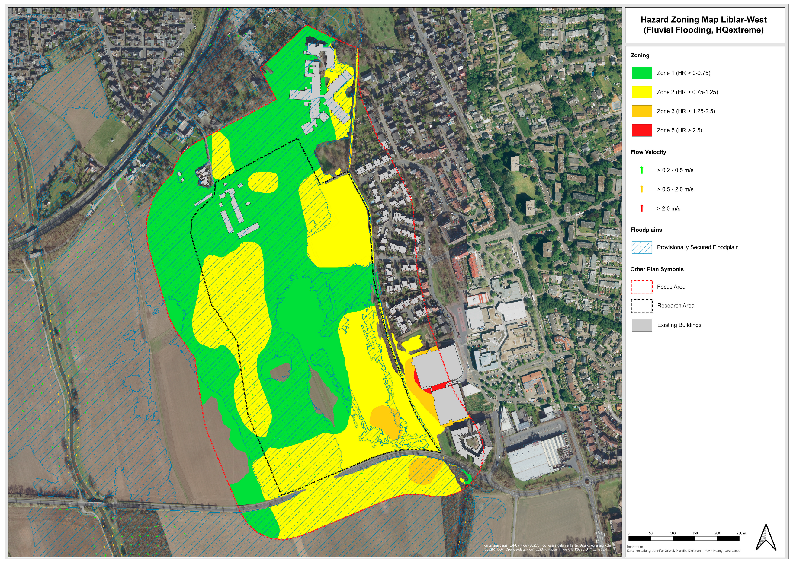
2.1. Analytical Basis: Hazard Zone Plan

In general, natural hazard zone is the division of any determined space into areas, which could be affected by hazardous phenomena to variable degrees [12]. It belongs to the so-called “risk matrix approaches”. The risk matrix is made of classes of frequency of the hazardous events on one axis, and permissible land use classes based on expected and, importantly, normatively acceptable consequences on the other axis [17,18,19,20,21,22,23,24,25,26,27,28,29,30,31,32]. The validity of this approach depends on the quality of the group of experts that is formed to identify the hazard scenarios, and that carries out the hazard filtering and ranking in several sub-stages characterized by frequency (probability) and impact classes and their corresponding normative implications in terms of permissible land use classes [13]. For the approach described in this paper, the selection and involvement of experts happened in two phases of the research, as shown above. In the analysis phase, expert support was retrieved from the interdisciplinary flood risk management research project KAHR; in the gaming simulation phase, the individual and institutional experts that are responsible for this management in real life also participated.
Our approach converts inundation depth ( d ), flow velocity ( v ), and a debris factor ( D F ) into a hazard rating ( H R ) by applying the following equation [33]:
H R = d × v + 0.5 + D F
The resulting index can be mapped in a hazard zone map, which divides the planned area into zones of similar hazard levels that require corresponding land use and construction restrictions as shown in Table 2.
Figure 2 is an exemplary flood zoning map of a fluvial extreme event with a return period greater than 100 years (HQextrem), which was developed by a group of graduate students for the Liblar-West area in Erftstadt based on the recommendations of the Department for the Environment, Food and Rural Affairs/Environment Agency [34]. It shows four different color-coded hazard zones in the planning area and its immediate perimeter. Zone 1 (green) covers areas with either shallow, slow-flowing surface discharge or deep stagnant water with limited danger for most people and the built environment [33]. A moderate hazard in zone 2 (yellow) describes a danger for some people and infrastructures because of either deep, flowing, or fast-flowing runoff (ibid.). Zone 3 (orange) experiences a significant flood hazard as deep, fast-flowing water is a danger to most people and built structures (ibid.). The most extreme hazard in zone 4 (red) is a result of the deepest waters flowing at the highest velocity and poses a threat to everyone as well as the built environment (ibid.).
Zones 3 and 4 should generally be kept free of buildings and only be developed in a nature-oriented way; however, temporary recreational uses may be considered in zone 3. The first two hazard zones allow for construction that meets criteria to reduce flood risk, e.g., prohibition of basements, exclusion of vulnerable uses in sub-terrain and ground levels or permanent and temporary protective devices to prevent the ingress of water. This differentiated approach to looking at flood hazards is the main advantage hazard zone has in contrast to the current practice in Germany. Complying with Art. 76 WHG, state authorities delineate floodplains where development is permissible under certain conditions (Art. 78 § 2 WHG) but is practically impossible. However, these floodplains do not distinguish between different intensities of flooding, i.e., they do not differentiate between shallow, stagnant water or a fast-flowing, deep stream. As this practice contradicts Objective I.1.1 of the BRPH, flood hazard zone offers an opportunity to evaluate a hazard and enable a risk-based approach to land use planning and permitting development under differentiated legal conditions.

2.2. Environmental Report with Integrated Hazard Zone Plan as Evidence Base for Risk-Based Planning

Environmental assessments are an essential part of environmental protection. In general, environmental assessment instruments aim to protect human health and the natural environment from the foreseeable and significant negative environmental impacts of projects or plans. In accordance with the European Union Environmental Impact Assessment Directive (2011/92/EU amended with the 2014/52/EU Directive) [34] and Strategic Environmental Assessment Directive (2001/42/EC) [35], a distinction must be made between an environmental impact assessment (EIA) for public and private projects, and a strategic environmental assessment (SEA) for programs and plans. While the EIA is used for the approval of environmentally significant projects, the SEA is carried out at a planning level, as important environmental decisions are often made in the context of preliminary plans and programs. Within the framework of appropriate procedures—including authorities, citizens and environmental reports—the possible environmental consequences of a project or plan can be identified at an early stage and considered in decision-making processes. Environmental assessments should contribute to project acceptance through transparency and public participation. This also gives planners and promoters greater planning certainty for the project in question [36,37,38,39].
The scope of application of German municipal urban land use planning comprises a more strategic and conceptually oriented preparatory urban land use plan for the entire area of a municipality (Flächennutzungsplan), for which an SEA must be carried out. It also requires a legally binding land use plan (Bebauungsplan) for new development zones, for which an integrated (strategic and project-related) assessment of the environmental impacts is mandatory. The choice of environmental assessment procedures depends on the respective national legislation. For the application of urban land use planning in Germany, the requirements of both the EU directives were jointly adopted by the Federal Building Code (Baugesetzbuch, BauGB). The integrated environmental assessment for binding urban land use planning has received a new basis through the adopted EIA Amendment Directive (2014/52/EU) [40], which now requires a risk assessment of major accidents and/or disasters. The Directive introduced the consideration of accidents and disasters in the EIA process, in the screening and in the required information and content of the environmental report. These requirements were implemented into national law in 2017 with an amendment to the BauGB.
According to Art 2 § 4 BauGB, an environmental assessment must be carried out in urban land use planning to take account of environmental protection issues. The probable, significant environmental effects must be determined, described and evaluated in an environmental report, which must be prepared in accordance with the requirements of Art. 2a S. 2 No. 2 BauGB and Annex 1 of the BauGB. The environmental report is a separate part of the justification for the binding land use plan, which summarizes the result of the environmental assessment in accordance with Art 2a S. 3 BauGB. Since the 2017 amendment to the BauGB, the principles of urban land use planning specify that, among other issues, environmental protection concerns and, in particular, impacts “[…] that are to be expected due to the susceptibility of the projects permitted under the binding land use plan to major accidents or disasters […]” must be considered when preparing urban land use plans (Art. 1 §. 6 No. 7 letter j BauGB). This also includes a description and assessment of the possible significant effects of the planned project because of “risks to human health, cultural heritage or the environment (for example, due to accidents or disasters)” (Annex 1 No. 2b double letter e) of the BauGB). These effects are examined within the framework of a risk assessment or evaluation.
Accordingly, during the environmental assessment, an examination that relates to the specific vulnerability of the projects that are permissible in accordance with a legally binding land use plan (Bebauungsplan) along with the consequences of a major accident and/or disaster is required [34,40]. For determining the relevance of accident and disaster risks, both their probability and the associated potential extent of damage must be considered, which, together, constitute the risk. The extent of damage depends on the respective characteristics, type and location of the project (i.e., the urban land use plan herein) [41,42]. This results in two central test factors:
  • The potential of the project to cause serious accidents/disasters. This explicitly refers to the risks to human health, cultural heritage and the environment [43].
  • The susceptibility (vulnerability) of the projects permitted under the binding land use plan to possible major accidents/disasters.
The requirements apply to both natural hazards (e.g., floods) and man-made disasters (e.g., major accident hazards) that could significantly affect the function of the project and have a negative impact [43]. The events that should be considered can be both internal to the project (self-caused, such as an incident) and external to the project (such as flooding or a neighboring incident). In general, severe accidents and/or disasters should be considered as part of an assessment if the project has the potential to cause loss of life, permanent injury and/or temporary or permanent destruction of an environmental receptor that cannot be readily restored [44].
The objective of the risk assessment in the environmental report is to identify and evaluate the potentially catastrophic risks and their impacts. The integrated identification and assessment of vulnerability to hazards and catastrophic risks aims to assess whether the project is indeed susceptible to such events and, if so, to provide recommendations to avoid/minimize these risks [45]. Thus, the basis of the prediction of expected environmental consequences is improved if the characteristics or vulnerabilities of the project or certain components (in this case, location in the flood hazard area) are known, from which consequent environmental impacts related to the protected component may occur. Vulnerability assessment simultaneously enables measures to strengthen the resilience (in the sense of reducing vulnerability) of a project as well as to mitigate disaster risk, which will be elaborated in the environmental assessment anyway (avoidance, mitigation or compensation) [42]. Thus, it also serves as a basis for deciding on possible and/or necessary preventive measures (e.g., stipulations in the land use plan) or alternatives (e.g., site selection) [43].
The environmental report on the Liblar-West land use plan addresses the foreseeable significant environmental impacts of the project with a focus on assessing the vulnerability of the permissible land uses in relation to the risk of a catastrophic flood (Figure 3). Flood hazard and risk maps or hazard zoning plans can be considered in urban land use plans according to different models and in different ways [45]. The environmental report for the gaming simulation did not consider all protected assets equally; instead, it primarily focused on the flood hazards affecting the area covered by the land use plan.
The contents of the environmental report served as an evidence basis to enable participants of the gaming simulation to discuss the possibilities and limits of flood-adapted land use planning.

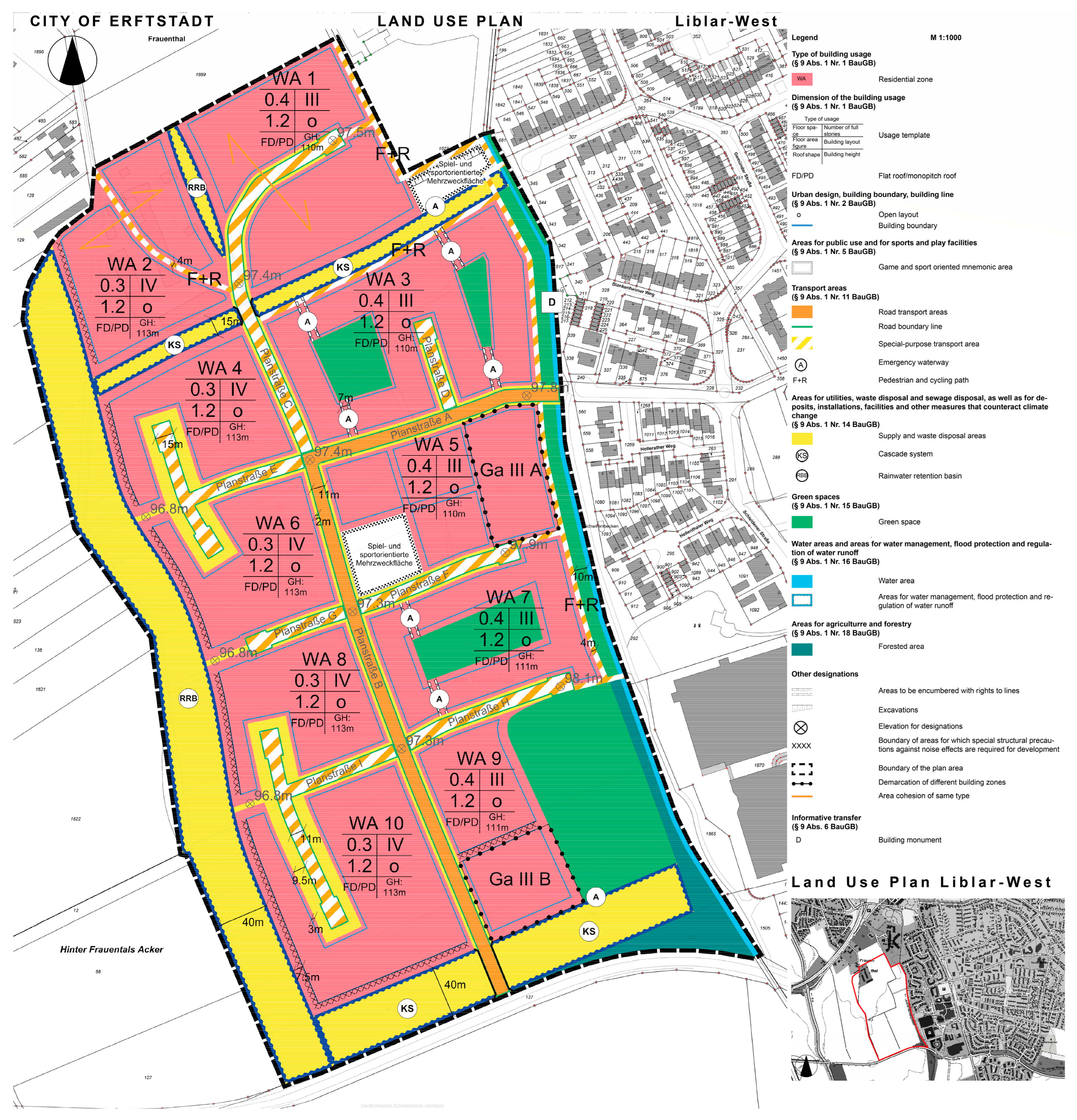
2.3. Flood-Adapted Land Use Plan

For the gaming simulation on flood-adapted land use planning in Erftstadt-Liblar-West, suitable textual and graphical designations and associated justifications were prepared in advance. For this purpose, we made use of the results of the analysis of a possible extreme flood event (HQextrem) [46] and the hazard zone plan developed from it, and we made them available to the participants (see Section 2.4).
According to the recalculation carried out in the wake of the flood event of July 2021, large parts of the Liblar-West planning area are located within the HQ100 of the Erft and within the provisionally secured floodplain, in which construction projects are only possible within the scope of an exemption according to Art. 78 WHG. The remaining parts of the planned area that would be flooded in the case of an extreme event (HQextrem) remain classified as risk areas in accordance with Art. 78b WHG.
As already described in the introduction, keeping all areas that were flooded by an extreme event (HQextrem) free of further settlement development can be helpful in individual cases; however, further differentiation appears necessary in relation to risk-based planning—particularly given the high demand for land in the area under investigation. Therefore, for the Liblar-West site, an examination of the hazard intensities (flood depth, flow velocities) that can be expected was carried out. In the event of an HQ100, most of the planned area will be flooded with water depths of up to 0.75 m, and up to 2 m in small areas. The hazard zone plan makes it possible to differentiate the flood hazard and thus to design a spatially differentiated flood-adapted construction method within the planned area.
In the case of building projects within designated flood plains, the legal regulations of Art. 78 WHG and Art. 84 Water Act of North-Rhine Westphalia must be observed, which include, in particular, the following points:
  • Flood retention will be unimpaired or insignificantly impaired and the loss of lost retention space will be extensively, functionally and temporally compensated.
  • Water levels and runoff during floods will not be adversely altered.
  • Existing flood protection will not be affected.
  • The structural facilities are designed to be flood-adapted.
The draft of the Liblar-West land use plan meets the requirements for flood-adapted construction in the form of numerous textual and graphical (Figure 4) designations that are based on various elements of risk-based flood prevention planning. The provisions were differentiated within the planned area—depending on the intensity of the hazard and the related flood zone derived from it. For example, a large area in the southeastern part of the planned area, where the highest flood depths are to be expected in the event of a flood, was kept completely free of buildings.
The designations described below explicitly address flood risk reductions in the specific area of Erftstadt-Liblar and are thus a selection from the entirety of designations and issues. Other issues such as archaeological, cultural, historical or landscape-related resources are typically addressed in the justification section (including the environmental report) of the land use plan but are not explained in detail in this section.

2.3.1. Designations for the Reduction of the Hazard Intensity

Built-up area: In the building blocks of the land use plan that are located in the more heavily flooded subarea (HR > 0.75–1.25 m) (WA 2, 4, 6, 8 and 10), a base area ratio of 0.3 is specified. This reduces the obstruction of runoff and the loss of retention space in the event of flooding compared to a higher base area ratio. The designation of the base area number in the remaining planned area is based on the concerns necessary for its use, and the upper limit in the general residential area, and is set at 0.4.
Multifunctional green areas: The public green spaces are designed to serve both the retention and infiltration of precipitation water, in accordance with Art. 9 § 1 No. 15 BauGB; a green space can be designated in conjunction with a specific purpose. Possible purposes are not exhaustively listed in the law. The purpose of (temporary) rainwater retention in green areas is legally possible; however, this offers starting points for water-sensitive urban development in the form of combined land use.

2.3.2. Designations for the Avoidance of Damage Potentials

Exclusion of vulnerable or endangering uses: In the building blocks (WA 2, 4, 6, 8, 9 and 10) that are heavily flooded in the event of an incident, ecclesiastical, cultural, social, health and sporting purposes pursuant to Art. § 2 No. 3 BauNVO and pursuant to Art. 1 §. 7 BauNVO, residential use and stores, pubs and restaurants serving the area in accordance with Art. 4 §. 2 No. 2 BauNVO are excluded on the first floor (danger to life and limb, presence of many people—including those not familiar with the area). In the entire planning area, the use of petrol stations, which is permissible as an exception in general residential areas in accordance with Art. 4 § 3 BauNVO, is prohibited (reduction of consequential hazards).
Exclusion of basement floors: This is necessary to prevent flood damage, as the ingress of water through basement openings is technically almost impossible to prevent due to high water pressure.
Inadmissibility of building services on the first floor: Installing technical facilities such as heating systems and house junction box in areas above the design flood HQextrem reduces damage in the event of flooding (reduction of damage potential, avoidance of ecological damage in the event of an incident, as well as rapid recommissioning afterwards).

2.3.3. Designations to Strengthen the Response Capacity in Case of an Incident

Road profile: The planned roads (A and B) are the main access routes of the neighborhood. Their cross-section should therefore be designed for their highest point to be in the middle of the roadway and thus remain available for emergency vehicles, for as long as possible, in the event of a flood event and retain their function as escape routes.
Construction Precautions: In the building blocks WA 2, 4, 6, 8, 9 and 10, a high depth of waterlogging occurs in a HQextrem event. To prevent or delay the ingression of floodwater into buildings, garage doors, windows and doors, they should be equipped with technical protective elements. Doors must be able to be opened in both directions, so that in the event of high water levels, it is possible to leave and gain access to the building (for rescue measures).

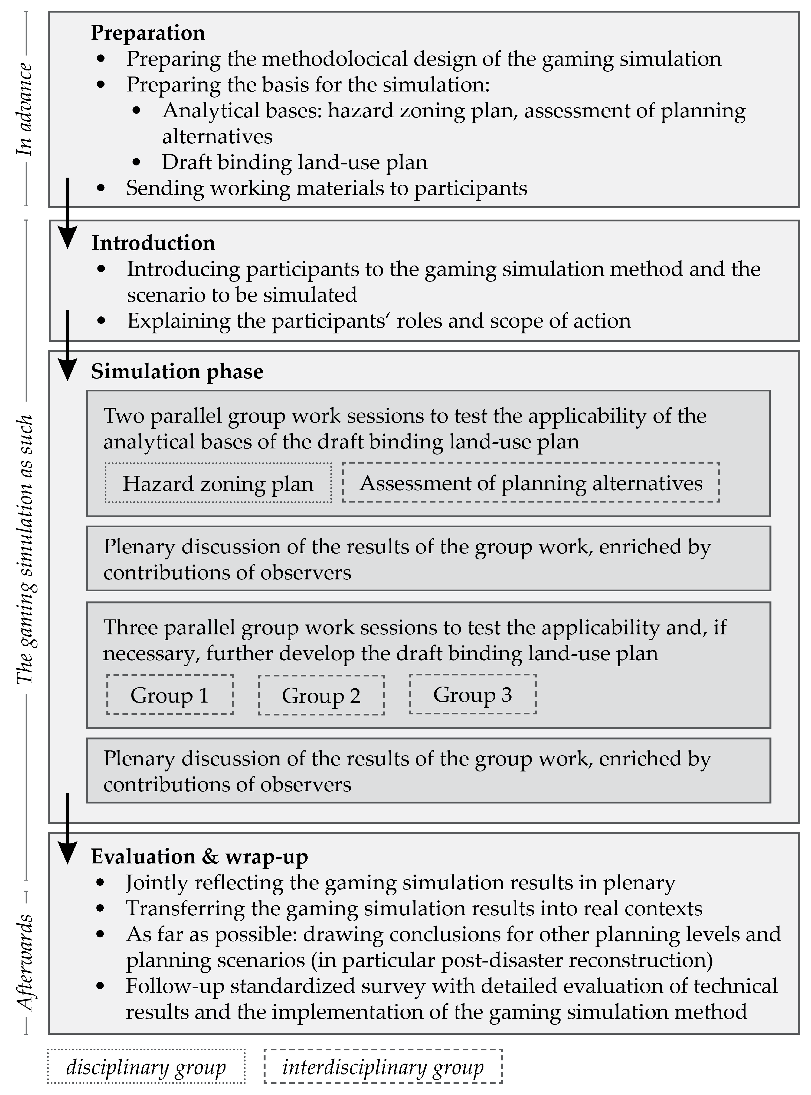
2.4. Gaming Simulation

Gaming simulations do not encapsulate a single, clearly definable method. As a methodological framework, they cover a wide range of methods that are different but that have characteristic features in common [47]. In general, gaming simulations are models or simulations that approximate reality. Actors with defined positions and scope for action make decisions in the context of a specific problem [30]. On the one hand, the gaming simulation allows us to examine complex structures and processes in general and the reality-relevant effects and consequences of the decisions that were made. Since the 1950s, gaming simulations have been widely used in the context of urban planning, especially in complex or new problem settings, such as new challenges, new analysis methods, new management approaches or even new laws.
In general, a gaming simulation consists of four phases:
  • Preparation;
  • Introduction and distribution of roles;
  • Simulation and negotiation phase (the gaming simulation as such);
  • Evaluation and wrap up;
High methodological and didactic competencies are associated with gaming simulations since the real people involved in them provide some emotional behavior or unpredictable behavior patterns into gaming simulations [47]. Such diverse spontaneously occurring social processes through interactions in groups do not exactly contribute to exactly standardizable study conditions but to an abundance of uncontrollable interactions and effects [48]. To increase the significance of research results and their acceptance in the scientific community, a closed (i.e., highly regulated) and rather simply designed gaming simulation with few variables and few participants is recommended.
Despite the methodological and didactic challenges, the gaming simulation is the appropriate methodological framework to realistically test the implementation of the newly introduced risk-based planning approach in urban land use planning. Classic formats, such as workshops, do not offer a concrete procedural or applicable reference which, due to its spatial reference, makes it easier to illuminate the implications of risk-based planning from the perspectives of those responsible. Other conceivable methods, such as legal opinions or (expert) interviews, would tend to remain in the realm of preliminary theoretical considerations because there has been no significant practical experience with the new approach in Germany to date. The gaming simulation enabled us to identify unforeseen problems during implementation in practice and enabled us to solve them directly.

2.4.1. Design of the Liblar-West Gaming Simulation

To test the risk-based planning approach using the example of an urban land use planning process for a flood-prone site in the district of Erftstadt-Liblar, we conducted a closed gaming simulation in the form of a performance simulation [48]. This required participants to take on the precise role that they have in real life. Around 70 participants were involved in this simulation. Among them, there were 20 active players from local planning authorities and agencies, who are usually invited to participate in real plan approval procedures (i.e., departments of the municipality conducting the procedure and so-called “public interest bodies”, such as the water and nature conservation authorities). In this case, they include participants from the departments and divisions of environmental protection and nature conservation, urban planning and building regulations, urban land use planning and transportation planning, as well as the municipal utilities that underline their broad range of qualifications. Furthermore, 50 observers from science, regional planning and neighboring regions took part. They include representatives from the district administrations of the Rhine-Erft district, to which the city of Erfstadt belongs, the neighboring district of Euskirchen and the district of Ahrweiler, which were also affected by the 2021 flood disaster. Thus, the higher-level district development, reconstruction staff and lower water authorities were represented. The Erftverband, responsible for the water management in the Erft catchment area, the North Rhine-Westphalia Chamber of Agriculture, the Bund für Umwelt und Naturschutz Deutschland (BUND), the Rhineland Transport Federation (go.Rheinland) and the Geological Service of the State of North Rhine-Westphalia were also involved. The Ministry of Economic Affairs, Industry, Climate Protection and Energy of the State of North Rhine-Westphalia (MWIKE NRW), the district governments of Arnsberg and Cologne, the Federal Institute for Building, Urban Affairs and Spatial Research (BBSR) and two working groups of the Academy for Territorial Development in the Leibniz Association (ARL) on climate adaptation and the Federal Spatial Plan for Flood Protection participated in a supporting, observing role.
In advance of the simulation, we equipped all participants with all necessary materials for the simulation according to a real process, and these included (a) the draft binding land use plan, (b) an explanatory memorandum and (c) an environmental report. We divided the simulation phase into four parts with two parallel group work sessions and two plenary discussions (see Figure 5). In the first working phase, the active players tested and validated the analytical basis of the draft land use plan, i.e., the environmental report including the hazard zone plan and the assessment of planning alternatives. In the second working phase, the playing participants validated the implementation of the risk-based planning approach in the draft land use plan. We completed the Liblar-West gaming simulation with a comprehensive evaluation, including the evaluation of technical results and the implementation of the methodological framework.

2.4.2. (Methodological) Reflection of the Liblar-West Simulation

To increase the significance of the research results, we designed the performance simulation in a mostly closed and rather simple way. The participants were subject to clear instructions through the realistic simulation of the highly regulated land use planning process. We provided the quasi “real” actors with “real” resources in the form of the materials that were mentioned previously. In addition, we guided the simulation by dividing the simulation phase into working phases with different guiding questions and tasks. Since the participants played their own role, which they also have in reality, they were able to contribute their expertise in the best possible way. The broad diversity of participants also ensured that all relevant information, interests and requirements from different sectors and levels of spatial planning could be incorporated into the simulation. This benefited both the practice-oriented and scientific classification of the simulation results. With the joint reflection of the gaming simulation during the evaluation and the transfer into the real context, the Liblar-West simulation fulfills an essential requirement for the meaningful use of the results.

3. Results

The hazard zone plan has proven to be a suitable instrument for operationalizing the consideration of flood prevention in areas prone to a risk of flooding in accordance with Art. 78 b WHG. In this way, a certain uniformity in the practice of urban land use planning could be made possible. A prerequisite for this, however, would be the dissemination of corresponding recommendations. This is the purpose of this article.
The simulation has also demonstrated, both from a scientific point of view and from the perspective of municipal planning practice, that it is readily possible to plan in a risk-based manner within the applicable legal framework of the BauGB and the BauNVO, and thus to implement Objective I.1.1 of the BRPH [25].
The state planning department of North-Rhine Westphalia, which was also represented in the gaming simulation, has adopted the hazard zone model for regional planning in this federal state. As part of the planned revision of the state development plan, the model will be introduced as a mandatory element for the local land use planning of all municipalities. Based on the suggestions of the simulation and subsequent bilateral discussions between the corresponding author and the ministry, each hazard zone class will be assigned to permissible land uses. The principle is that particularly sensitive land uses worthy of protection, such as critical infrastructures and social facilities, will be excluded even at a comparatively low risk of flooding, while other uses, such as housing, remain permissible under the condition of sufficient building precautions and will be excluded only at a comparatively high risk of flooding, as described in Table 3.

4. Discussion

Spatial planning can contribute in many ways to a preventive flood risk management by implementing elements of a risk-based planning approach [3,4,5,6,7,8,9,10,11]. Although such innovative elements are well known, there is a lack in common practice regarding their implementation, not only in Germany but also in the majority of the EU countries. This mainly relates to a collaborative approach across sectors, the consideration of vulnerability data, a multi-hazard risk assessment, the consideration of critical infrastructures, making use of scenarios of future development and the primary integration of risk assessment and management into spatial planning by hazard zone [24].
Our paper shows that some of these requirements for good flood risk management practice were successfully applied and tested in an environment close to a real-life setting (gaming simulation). Importantly, it is not the current vulnerability, but the future vulnerability of the designated land use that matters under the Environmental Impact Assessment Directive [34]. A certain innovative element of our approach is the consideration of protection worthiness that is normally not addressed by hazard zone approaches in land use planning [11]. Specific infrastructures are not necessarily physically more vulnerable than other structures; however, it is the effects of flooding that may cause secondary or cascading effects on other infrastructure sectors even outside the exposed areas that are usually not considered by traditional risk assessments [49,50,51,52]. That is why the acceptable level of flood risk should be lower for these critical infrastructures than for ordinary land uses.
We investigated and tested various options that land use planning has at hand for flood risk prevention in accordance with the given legal framework. It can mitigate the flood hazard itself by designating water retention areas and redirecting possible water flows, as well as the related damage potentials, and laying down mandatory building protection measures whose necessity depends on the land use specific sensitivity and protection worthiness. Both options are—according to the literature—quite cost-effective [53,54] and avoid the so-called “levee” effect [55], which describes a feeling of false security by people living behind structural protection systems such as levees. Finally, land use planning can contribute to emergency management responses by optimizing the accessibility of an area for interventions and evacuations [56]. Overall, the readability of flood maps is an important framework condition for the derivation of tailor-made designations [57].
The simulation involved several stakeholders and allowed a collaborative approach across sectors that looked at a new settlement development in an area that is currently used for agricultural purposes. Nevertheless, the principle of risk-based planning can also be applied in the recovery phase in the aftermath of flood events to apply the “built back better” principle that is propagated by Priority 4 of the Sendai Framework for disaster risk reduction [19]. This is also the case concerning the obligatory building precautions when claiming reconstruction aid after the flood event of July 2021, at least for the state of North-Rhine Westphalia, as presented by Art. 7.5 and 7.6 of the Funding Guideline on Reconstruction [58]. The same applies to the densification of sparsely built-up areas and brownfield revitalization. Here, the importance of the BRPH is even higher since the planning and construction ban of Art. 78 WHG only applies to the first-time use of a floodplain for settlement purposes. Thus, complementary actions with the use of spatial planning, as shown by this paper, are required to legally anchor flood prevention in built-up areas. Therefore, there among the participants of the gaming simulation agreed that it would be worthwhile to conduct a similar format for other types of areas.
The adoption of the hazard zone approach by the state planning department of the federal state of North-Rhine Westphalia, whose representatives took part of the gaming simulation, is an important achievement. The hazard zone approach will become part of the statewide spatial development plan whose designations are binding for all municipalities in North-Rhine Westphalia. Consequently, any future local land use plan whose planning area is prone to floods must follow the concept that is described in this paper. This legal effect values the applicability of the presented methodological approach.
In the long term, however, it is also conceivable to replace floodplains with hazard zones that are based on the actual intensity of the hazard in a more differentiated manner, since floodplains are only based on the spatial perimeter of the corresponding areas. This would consider the real flood risk more accurately than the current legal water management framework in Germany.
Due to the nature of the gaming simulation, which simulated a discussion meeting with public interest groups, it was naturally necessary to leave the question of the acceptance of such far-reaching specifications by land developers open for discussion. However, it can be assumed that this depends not only on the attractiveness of the building area in terms of urban development but also on the demand of the situation in the relevant municipality. The greater the shortage of building land or living space, the more likely it is that restrictions will be accepted. This is also valid for settings outside of the region and outside of Germany, especially in dynamic economies with a large housing and infrastructure demand. However, this is only true under the prerequisite that municipalities and, even more importantly, private landowners and dwellers follow the law. This preventive approach must fail under weak law enforcement and a rapid expansion of the urban fabric. Hazard zone approaches remain relevant here, since they define areas of so-called “non-mitigatable risks” for which mandatory resettlement activities are required in a couple of countries [59,60].
It was a first time for many participants to be taking part in a gaming simulation and thus they needed some time to familiarize themselves with this method. Some of the participants had some initial difficulties in understanding that it was a simulation. Therefore, it obviously makes sense to include a note to that effect on all documents. In addition, some participants were confronted with stakeholders from other sectors and planning levels for the first time in such a context. Thus, unfamiliar situation occasionally led to discussions between participants, regardless of their respective roles. Thus, it required better methodological skills to be issued by the moderators. Furthermore, we observed that these challenges decreased as participants became more familiar in conducting gaming simulations, or cross-sectoral and cross-level collaboration, in general, over the course of the day. Finally, the gaming simulation approach should be improved by implementing an element that considers the written expert opinions of the various public authorities that should be involved, as well as the expressed interest of the affected population, as is customary in real plan approval procedures [61].

5. Conclusions

As our paper clearly shows, land use planning can be guided by each hazard zone by combining both components of risk—the hazard frequency and intensity (with which a certain area is characterized by) and the vulnerability (research question a). In respect to research question b, it became clear that land use planning can mitigate the flood risk by improving retention capacities and redirecting water flows. Guided by the hazard map, it can reduce the exposure of land to floods that are specifically endangered and worth to protect by keeping those areas free of development. The reduction of vulnerability requires tailor-made building-related designations. The gaming simulation itself has already proven the principle applicability of the hazard zone approach in line with the German legal framework. Moreover, the state planning authority of the federal state of North-Rhine Westphalia has already adopted it (research question c).
Overall, our findings contribute to the implementation of the risk-based planning approach. Our study revealed practical needs for implementing the planning approach, such as the clearer definition of guidelines for stakeholders when weighing planning concerns in the land use planning process or the fundamental questioning of the distribution of responsibility and costs, which is particularly crucial when land developers or owners are included [61]. Nonetheless, the gaming simulation, as a method to test the general applicability of new instruments and flood risk management options, is worth to be applied to other cases worldwide that are not dependent from the point of view of a specific legal-administrative setting [62].
Nevertheless, further research should be dedicated to the testing of this planning approach in built-up areas, as there is a need for a flood-proof retrofitting of the existing building stock and the implementation of the “Build back better” principle [19] during the recovery phase in the aftermath of a disaster [63]. This is particularly challenging for land use planning since individual property rights of house owners have to be taken into consideration and cannot be questioned by designations in land use plans. In this context, market-based solutions, such as buy-out programs, could play a relevant role [58,64].

Author Contributions

Conceptualization, S.G.; methodology, S.G. and M.F. (Marisa Fuchs); validation and visualization, F.O.; formal analysis, P.K. and F.O.; data curation, P.K. and M.F. (Marisa Fuchs); writing—original draft preparation, S.G., F.O., M.F. (Mark Fleischhauerand), P.K. and M.F. (Marisa Fuchs); writing—review and editing, P.K.; funding acquisition, S.G. All authors have read and agreed to the published version of the manuscript.

Funding

The project KAHR—Climate Adaptation, Flooding and Resilience, Subproject 12 (2021–2024), on which this paper is based, was funded by the German Federal Ministry of Education and Research under grant number 01LR2102L. We acknowledge financial support by Deutsche Forschungsgemeinschaft and Technische Universität Dortmund/TU Dortmund University within the funding programme Open Access Costs.

Informed Consent Statement

Informed consent was obtained from all subjects involved in the study.

Data Availability Statement

No new data were created or analyzed in this study. Data sharing is not applicable to this article.

Acknowledgments

We would like to thank the participants of the master student project “Flood Risk Management and Reconstruction Planning as a Task of Urban Land Use Planning” at the TU Dortmund University, who developed central principles for the simulation in the winter semester of 2022/23. Participating students (in alphabetical order): Mareike Diekmann, Anna Wilma Dorothea Eikenberg, Pascal Eßer, Kevin Hoang, Chiara-Charlotte Iodice, Sören Jäger, Nicole Landheer, Lara Lenze, Jennifer Oriwol, Leonie Schiermeyer, Alexander Thüs and Matthias Zimny. Further thanks go to the city of Erftstadt for the provision of data and information as well as the co-design and intensive participation in the Liblar-West simulation.

Conflicts of Interest

The authors declare no conflict of interest. The funders had no role in the design of the study; in the collection, analyses, or interpretation of data; in the writing of the manuscript; or in the decision to publish the results.

References

  1. Stein, L.A. Comparative Urban Land Use Planning. Best Practice; Sydney University Press: Sydney, Australia, 2017. [Google Scholar]
  2. Reimer, M.; Getimis, P.; Blotevogel, H.H. Spatial Planning Systems and Practices in Europe. A Comparative Perspective on Continuity and Changes; Routledge Taylor & Francis Group: London, UK; New York, NY, USA, 2014. [Google Scholar]
  3. Burby, R.J. Cooperating with Nature—Confronting Natural Hazards with Land-Use Planning for Sustainable Communities; Joseph Henry Press: Washington, DC, USA, 1998. [Google Scholar]
  4. Godschalk, D.R.; Beatley, T.; Berke, P.; Brower, D.J. Natural Hazard Mitigation—Recasting Disaster Policy and Planning; Island Press: Washington, DC, USA, 1999. [Google Scholar]
  5. Greiving, S.; Fleischhauer, M.; Wanczura, S. European Management of Natural Hazards: The Role of Spatial Planning in selected Member States. J. Environ. Plan. Manag. 2006, 49, 739–757. [Google Scholar] [CrossRef]
  6. World Bank. Land Use Planning for Urban Flood Risk Management; Urban Floods Community of Practice Knowledge Notes; World Bank: Washington, DC, USA, 2017; Available online: http://hdl.handle.net/10986/26654 (accessed on 10 September 2023).
  7. Struik, L.C.; Pearce, L.D.; Dercole, F.; Shoubridge, J.; van Zijll de Jong, S.; Allan, J.D.; Hastings, N.L.; Clague, J.J. Risk-Based Land-Use Guide: Safe Use of Land Based on Hazard Risk Assessment. Geological Survey of Canada. Open File 7722. Ottawa 2015. Available online: https://www.unisdr.org/preventionweb/files/53964_gscof7772riskbasedlanduseguidevol1.pdf (accessed on 10 September 2023).
  8. Der Sarkissian, R.; Al Sayah, M.J.; Abdallah, C.; Zaninetti, J.M.; Nedjai, R. Land Use Planning to Reduce Flood Risk: Opportunities, Challenges and Uncertainties in Developing Countries. Sensors 2022, 22, 6957. [Google Scholar] [CrossRef] [PubMed]
  9. The Australian Institute for Disaster Resilience. Planning Safer Communities—Land Use Planning for Natural Hazards; Australian Institute for Disaster Resilience: Melbourne, Australia, 2002; Available online: https://knowledge.aidr.org.au/media/1958/manual-7-planning-safer-communities.pdf (accessed on 10 September 2023).
  10. King, D.; Gurtner, Y.; Firdaus, A.; Harwood, S.; Cottrell, A. Land use planning for disaster risk reduction and climate change adaptation: Operationalizing policy and legislation at local levels. Int. J. Disaster Resil. Built Environ. 2016, 7, 158–172. [Google Scholar] [CrossRef]
  11. Word Meteorological Organization. The Role of Land Use Planning in Flood Management; Integrated Flood Management Tools Series No. 7 Version 2.0. Word Meteorological Organization: Geneva, Switzerland, 2016; Available online: https://www.floodmanagement.info/publications/tools/APFM_Tool_07.pdf (accessed on 10 September 2023).
  12. Schmidt-Thomé, P.; Greiving, S. Zoning. In Bobrowsky, P.T. Encyclopedia of Natural Hazards; Encyclopedia of Earth Sciences Series; Springer: Dordrecht, The Netherlands, 2013. [Google Scholar] [CrossRef]
  13. Haimes, Y.Y. Risk Modeling, Assessment, and Management, 3rd ed.; John Wiley & Sons: Totnes, UK, 2009; 1009p. [Google Scholar]
  14. Directive 2007/60/EC of the European Parliament and of the Council of 23 October 2007 on the Assessment and Management of Flood Risks. Available online: https://www.google.com.hk/url?sa=t&rct=j&q=&esrc=s&source=web&cd=&cad=rja&uact=8&ved=2ahUKEwiAtoGi9I6CAxVsqVYBHVrGDcgQFnoECAgQAw&url=https%3A%2F%2Fwww.legislation.gov.uk%2Feudr%2F2007%2F60&usg=AOvVaw00Hri3la1FDnCHxkL2FQAX&opi=89978449 (accessed on 10 September 2023).
  15. Fell, R.; Whitt, G.; Miner, A.; Flentje, P.N. Guidelines for landslide susceptibility, hazard and risk zoning for land use planning. Aust. Geomech. J. 2007, 42, 13–36. [Google Scholar]
  16. Saunders, W.S.A.; Kilvington, M. Innovative land use planning for natural hazard risk reduction: A consequence-driven approach from New Zealand. Int. J. Disaster Risk Reduct. 2016, 18, 244–255. [Google Scholar] [CrossRef]
  17. van Westen, C.; Greiving, S. Risk Assessment and Decision Making. In Environmental Hazards Methodologies for Risk Assessment and Management; Dalezios, N.R., Ed.; IWA Publishing: London, UK, 2017; pp. 31–94. [Google Scholar]
  18. Kimura, Y.; Hirabayashi, Y.; Kita, Y.; Zhou, X.; Yamazaki, D. Methodology for constructing a flood-hazard map for a future climate. Hydrol. Earth Syst. Sci. 2023, 27, 1627–1644. [Google Scholar] [CrossRef]
  19. UN-ISDR. Sendai Framework for Disaster Risk Reduction 2015–2030; UN-ISDR: Geneva, Switzerland, 2015; Available online: https://www.preventionweb.net/files/43291_sendaiframeworkfordrren.pdf (accessed on 10 September 2023).
  20. UN-Habitat. The New Urban Agenda. Available online: https://unhabitat.org/sites/default/files/2020/12/nua_handbook_14dec2020_2.pdf (accessed on 10 September 2023).
  21. Poljanšek, K.; Marin-Ferrer, M.; De Groeve, T.; Clark, I. Science for Disaster Risk Management 2017: Knowing Better and Losing Less; EUR 28034 EN; Publications Office of the European Union: Luxembourg, 2017. [Google Scholar] [CrossRef]
  22. ECA—European Court of Auditors. Floods Directive: Progress in Assessing Risks, While Planning and Implementation Need to Improve; Special Report No. 25 (Pursuant to Article 287(4), Second Subparagraph, TFEU); Publications Office of the European Union: Brussels, Belgium, 2018. [Google Scholar]
  23. Poljanšek, K.; Casajus-Valles, A.; Marin-Ferrer, M.; De Jager, A.; Dottori, F.; Galbusera, L.; Garcia-Puerta, B.; Giannopoulos, G.; Girgin, S.; Hernandez-Ceballos, M.; et al. Recommendations for National Risk Assessment for Disaster Risk Management in EU; EUR 29557; Publications Office of the European Union: Luxembourg, 2019. [Google Scholar] [CrossRef]
  24. Cantergiani, C.; Feliu, E. ESPON-TITAN—Territorial Impacts of Natural Disasters; Final Report; Applied Research; ESPON EGTC: Luxembourg, 2021; ISBN 978-2-919816-06-4. [Google Scholar]
  25. BMI—Bundesministerium des Inneren und für Heimat. Ordinance on Spatial Planning in the Federal Government for Cross-State Flood Protection (BRPHV). Federal Law Gazette, 25 August 2021; Part I No. 57. [Google Scholar]
  26. The European Parliament and the Council of The European Union. DIRECTIVE (EU) 2022/2557 of the European Parliament and of the Council of 14 December 2022 on the Resilience of Critical Entities and Repealing Council Directive 2008/114/EC. Off. J. Eur. Union 2022, L333, 164. [Google Scholar]
  27. BBSR. Handbuch zur Ausgestaltung der Hochwasservorsorge in der Raumordnung. Available online: https://www.bbsr.bund.de/BBSR/DE/Veroeffentlichungen/ministerien/MOROPraxis/2017/moro-praxis-10-17-dl.pdf?__blob=publicationFile&v=2 (accessed on 10 September 2023).
  28. BBSR. Testlauf Bundesraumordnungsplan. Hochwasserschutz (Phase 2). Available online: https://www.bbsr.bund.de/BBSR/DE/forschung/programme/moro/studien/2018/testlauf-brop-hochwasserschutz/dl-brph-p2-testplan.pdf?__blob=publicationFile&v=1 (accessed on 10 September 2023).
  29. The Federal Government. German Strategy for Strengthening Resilience to Disasters; Implementing the Sendai Framework for Disaster Risk Reduction (2015–2030)—Germany’s Contribution 2022–2030; The Federal Government: Berlin, Germany, 2022. Available online: https://www.bbk.bund.de/SharedDocs/Downloads/DE/Mediathek/Publikationen/Sendai-Katrima/deutsche-strategie-resilienz-kurz-eng_download.pdf?__blob=publicationFile&v=4 (accessed on 10 September 2023).
  30. Meier, R.L.; Duke, R.D. Gaming simulation for urban planning. J. Am. Inst. Plan. 1966, 32, 3–17. [Google Scholar] [CrossRef]
  31. BMBF-Project KAHR for Rhineland-Palatinate and North Rhine-Westphalia: Climate Adaptation, Flooding and Resilience. Available online: https://hochwasser-kahr.de/index.php/en/ (accessed on 10 September 2023).
  32. Maranzoni, A.; D’Oria, M.; Rizzo, C. Quantitative flood hazard assessment methods: A review. J. Flood Risk Manag. 2022, 16, e12855. [Google Scholar] [CrossRef]
  33. HRW—HR Wallingford. R&D Outputs: Flood Risks to People, Phase 2, 11545th ed.; FD2321/TR1 The Flood Risks to People Methodology; HRW: Wallingford, UK, 2006. [Google Scholar]
  34. The European Parliament and the Council of The European Union. Directive 2014/52/EU of the European Parliament and of the Council of 16 April 2014 amending Directive 2011/92/EU on the assessment of the effects of certain public and private projects on the environment. Off. J. Eur. Union 2014, L124, 1. [Google Scholar]
  35. European Parliament, Council of the European Union. Directive 2001/42/EC of the European Parliament and of the Council of 27 June 2001 on the assessment of the effects of certain plans and programmes on the environment. Off. J. Eur. Union 2001, L197, 30. [Google Scholar]
  36. EC (European Commission). Directorate-General for Environment. Guidance on Integrating Climate Change and Biodiversity into Environmental Impact Assessment; European Commission: Brussel, Belgium, 2013. [Google Scholar] [CrossRef]
  37. BMUV (Federal Ministry for the Environment, Nature Conservation, Nuclear Safety and Consumer Protection). Environmental Assessments EIA/SEA; BMUV: Berlin, Germany, 2023. Available online: https://www.bmuv.de/en/topics/education-participation/overview-citizen-participation/environmental-assessments-eia/sea (accessed on 10 October 2023).
  38. Glasson, J.; Therivel, R. Introduction to Environmental Impact Assessment, 5th ed.; Routledge: New York, NY, USA, 2019; ISBN 1138600741. [Google Scholar]
  39. McCallum, S.; Dworak, T.; Prutsch, A.; Kent, N.; Mysiak, J.; Bosello, F.; Klostermann, J.; Dlugolecki, A.; Williams, E.; König, M.; et al. Support to the Development of the EU Strategy for Adaptation to Climate Change: Background Report to the Impact Assessment, Part I—Problem Definition, Policy Context and Assessment of Policy Options; Environment Agency Austria: Vienna, Austria, 2013.
  40. Battis, U.; Moench, C.; Uechtritz, M.; Mattes, C.; von der Groeben, C. Expert Opinion on the Implementation of the EIA Amendment Directive in the Building Code on Behalf of BBSR. Bonn 2015. Available online: http://www.bmub.bund.de/fileadmin/Daten_BMU/Download_PDF/Staedtebaurecht/baugb_gutachten_uvp_aendrl_bf.pdf (accessed on 29 February 2016).
  41. Deutscher Bundestag. Entwurf Eines Gesetzes zur Umsetzung der Richtlinie 2014/52/EU im Städtebaurecht und zur Stärkung des neuen Zusammenlebens in der Stadt; Draft Bill of the Federal Government, 18th Legislative Period; Printed Matter 18/10942; Deutscher Bundestag: Berlin, Germany, 2017.
  42. Hartlik, J. Requirements for the EIA Report Under Consideration of Methodological and Content-Related Practicability—Part 1. EIA Rep. 2020, 34, 3–14. [Google Scholar] [CrossRef]
  43. EC (European Commission). Environmental Impact Assessment of Projects. Guidance on the Preparation of the Environmental Impact Assessment Report (Directive 2011/92/EU as Amended by 2014/52/EU); Publications Office of the European Union: Luxembourg, 2017; ISBN 978-92-7974374-0. [Google Scholar]
  44. IEMA (Institute of Environmental Management & Assessment). Major Accidents and Disasters in EIA: A Primer; ARUP: Lincoln, UK, 2020. [Google Scholar]
  45. Prenger-Berninghoff, K. Integrating risk assessment and risk management into the environmental assessment of urban land use plans. UVP-Rep. 2017, 31, 192–201. [Google Scholar] [CrossRef]
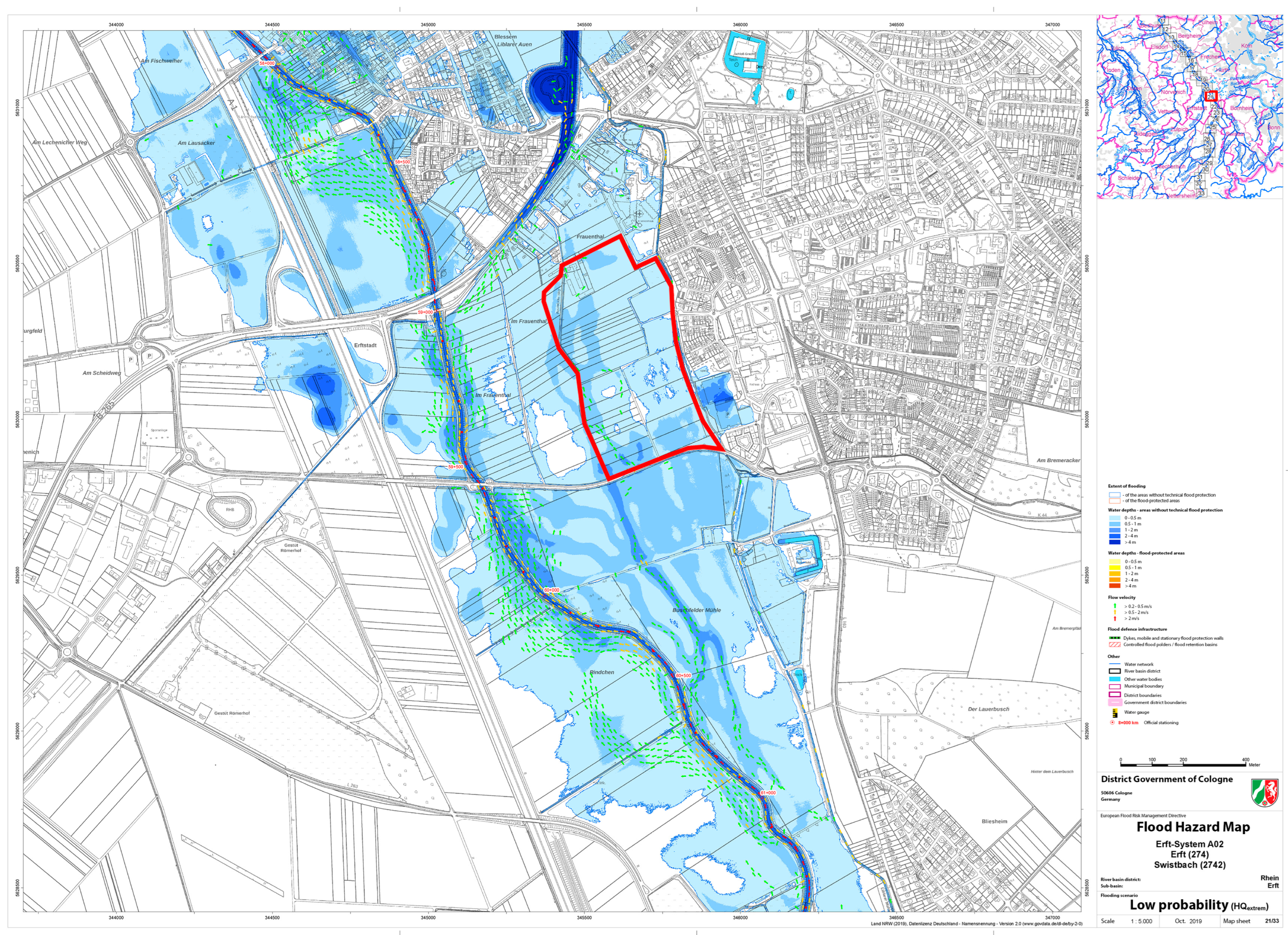
  46. Cologne District Government. Flood Hazards and Risk Maps Sub-Catchment Erft. Map Sheet 21/33. 2019. Available online: https://www.flussgebiete.nrw.de/system/files/atoms/files/274_erft_system_a02_gk_nw_b021.pdf (accessed on 10 September 2023).
  47. Kriz, W. Planspiel. In Handbuch Methoden der Organisationsforschung, 1st ed.; Kühl, S., Ed.; Verlag für Sozialwissenschaften: Wiesbaden, Germany, 2009; pp. 558–578. [Google Scholar] [CrossRef]
  48. Kriz, W.; Hense, J.U. Theory-oriented evaluation for the design of and research in gaming and simulation. Simul. Gaming 2006, 37, 268–283. [Google Scholar] [CrossRef]
  49. Katina, P.F.; Hester, P.T. Systemic determination of infrastructure criticality. Int. J. Comput. Inf. Syst. 2013, 9, 211–225. [Google Scholar] [CrossRef]
  50. Pescaroli, G.; Alexander, D. A definition of cascading disasters and cascading effects: Going beyond the “toppling dominos” metaphor. PlanetRisk 2015, 2, 58–67. [Google Scholar]
  51. Fekete, A. Common criteria for the assessment of critical infrastructures. Int. J. Disaster Risk Sci. 2011, 2, 15–24. [Google Scholar] [CrossRef]
  52. Lukitsch, K.; Müller, M.; Stahlhut, C. Criticality. In Key Concepts for Critical Infrastructure Research; Engels, J.I., Ed.; Springer: Wiesbaden, Germany, 2018; pp. 11–20. ISBN 978-3-658-22920-7. [Google Scholar]
  53. Aerts, J. A Review of Cost Estimates for Flood Adaptation. Water 2018, 10, 1646. [Google Scholar] [CrossRef]
  54. de Ruig, L.T.; Haera, T.; de Moela, H.; Wouter Botzena, W.; Aerts, J. A micro-scale cost-benefit analysis of building-level flood risk adaptation measures in Los Angeles. Water Resour. Econ. 2020, 32, 100147. [Google Scholar] [CrossRef]
  55. Ventimiglia, U.; Candela, A.; Aronica, G.T. A Cost Efficiency Analysis of Flood Proofing Measures for Hydraulic Risk Mitigation in an Urbanized Riverine Area. Water 2020, 12, 2395. [Google Scholar] [CrossRef]
  56. Neuvel, J.M.M.; Van den Brink, A. The consideration of emergency management issues in spatial planning practices. Environ. Plan. C Gov. Policy 2009, 28, 37–53. [Google Scholar] [CrossRef]
  57. Meyer, V.; Kuhlicke, C.; Luther, J.; Fuchs, S.; Priest, S.; Dorner, W.; Serrhini, K.; Pardoe, J.; McCarthy, S.; Seidel, J. Recommendations for the user-specific enhancement of flood maps. Nat. Hazards Earth Syst. Sci. 2012, 12, 1701–1716. [Google Scholar] [CrossRef]
  58. Ministerium für Heimat, Kommunales, Bau und Gleichstellung. Richtlinie über die Gewährung von Billigkeitsleistungen des Landes Nordrhein-Westfalen zur Beseitigung von Schäden an öffentlicher und privater Infrastruktur sowie zum Wiederaufbau anlässlich der Starkregen- und Hochwasserkatastrophe im Juli 2021 (Förderrichtlinie Wiederaufbau Nordrhein-Westfalen). Ministerialblatt (MBl. NRW.), 7 June 2022; pp. 409–472. [Google Scholar]
  59. Greiving, S.; Juan, D.; Puntub, W. Managed retreat—International and comparative perspectives. J. Extrem. Events 2018, 5, 1850011. [Google Scholar] [CrossRef]
  60. Lauer, H.; Delos Reyes, M.; Birkmann, J. Managed Retreat as Adaptation Option: Investigating Different Resettlement Approaches and Their Impacts—Lessons from Metro Manila. Sustainability 2021, 13, 829. [Google Scholar] [CrossRef]
  61. Valcik, N.A.; Jordam, T.A.; Benavides, T.J.; Stigdon, A.D. City Planning for the Public Manager; Routledge: New York, NY, USA, 2017. [Google Scholar]
  62. Solinska-Nowak, A.; Magnuszewski, P.; Curl, M.; French, A.; Keating, A.; Mochizuki, J.; Liu, W.; Mechler, R.; Kulakowska, M.; Jarzabek, L. An overview of serious games for disaster risk management—Prospects and limitations for informing actions to arrest increasing risk. Int. J. Disaster Risk Reduct. 2018, 31, 1013–1029. [Google Scholar] [CrossRef]
  63. Birkmann, J.; Schüttrumpf, H.; Handmer, J.; Thieken, A.; Kuhlicke, C.; Truedinger, A.; Sauter, H.; Klopries, E.-M.; Greiving, S.; Jamshed, A.; et al. Strengthening resilience in reconstruction after extreme events—Insights from flood affected communities in Germany. Int. J. Disaster Risk Reduct. 2023, 96, 103965. [Google Scholar] [CrossRef]
  64. Freudenberg, R.; Calvin, E.; Tolkoff, L.; Brawley, D. Buy-In for Buyouts: The Case for Managed Retreat from Flood Zones; Lincoln Institute of Land Policy: Cambridge, MA, USA, 2016. [Google Scholar]
Figure 1. Small group work in the context of the gaming simulation in Erftstadt Liblar-West (source: own figure).
Sustainability 15 15340 g001
Figure 2. Zoning map of Liblar-West (flooding, extreme event HQextrem). Source: own figure.
Sustainability 15 15340 g002
Figure 3. Flood hazard map Erft for extreme event HQextrem, map sheet 21/33 with planned area (red). [46].
Sustainability 15 15340 g003
Figure 4. Draft of the Erftstadt Liblar-West binding land use plan, with drawing specifications, as a basis for the gaming simulation. Source: own figure.
Sustainability 15 15340 g004
Figure 5. Structure and concept of the Liblar-West simulation. Source: own figure.
Sustainability 15 15340 g005
Table 1. Justification of protection worthiness. Source: own table.
Types of
Infrastructures
ExamplesLegal BasisJustification
Infrastructures that cause major accident hazards if hit by an extreme eventEstablishments where dangerous substances are presentSEVESO III Directive (2012/18/EU) on the control of major accident hazardsAvoidance of secondary effects due to the contamination of groundwater, soil, air human assets and human beings
Sensible infrastructuresHospitals, schools,
homes for the elderly
Art. 1 of the Law on Fire Protection, Assistance and Civil Protection (BHKG NRW)Avoidance of injuries/fatalities to groups of people who need assistance in the event of an incident
Built heritageUNESCO world heritage; other historic monumentsHague Convention for the Protection of Cultural Property (1972) and World Heritage Convention (1972)Symbolic criticality: Destruction can emotionally shake a society and unbalance it
Critical infrastructuresUtility networks (gas, water, electricity, telecommunications) and transport networksCER Directive on the resilience of critical entities (2022/2557/EC)Avoidance of service disruptions that cause domino and cascade effects
Table 2. Hazard zones. Source: own table.
(HR)LevelZoneDescription
0 < HR < 0.75Low1Floodplain with shallow, standing or slow-moving water.
0.75 ≤ HR < 1.25Moderate2Floodplain with shallow to moderately deep or moderately flowing water.
1.25 ≤ HR < 2.5High3Floodplain with deep or moderately flowing water.
HR ≥ 2.5Extreme4Flooded area with very deep and/or fast-flowing water.
The colors from green to red express the severity of the flood hazard and are used to create easily understandable hazard maps.
Table 3. Permissible land use classes. Source: own table.
Hazard Zone Permissible Land Use Classes
1All types of buildings may be permitted. Special protection is required for the following types of buildings:
a. In which there are groups of people who would have to be evacuated in the event of an incident (hospitals, homes for the elderly, kindergartens);
b. That are critical infrastructures which are sensitive to the effects of flooding;
c. Dangerous facilities from which domino effects emerge in the event of a flood (e.g., the release of environmentally hazardous substances).
They should be constructed in such a way that the first-floor level remains free of damage by setting appropriate minimum elevation heights above ground level.
2All types of buildings may be permitted. Special protection is required for the following types of buildings:
a. In which there are groups of people who would have to be evacuated in the event of an incident (hospitals, homes for the elderly, kindergartens);
b. That are critical infrastructures which are sensitive to the effects of flooding;
c. Facilities from which domino effects emerge in the event of a flood (e.g., the release of environmentally hazardous substances).
They should be constructed in such a way that the first-floor level remains free of damage by setting appropriate minimum elevation heights above ground level. Basements should generally be excluded.
3 The permissibility of the construction or expansion of land uses in categories a–c requiring special protection should normally be excluded, unless they can be structurally designed in such a way that the following aspects can be avoided:
a. Risks to life and limbs;
b. Loss of function in the case of critical infrastructures;
c. Domino effects.
When permitting other building uses, appropriate minimum heights above ground level should be specified and basements should be excluded.
4 The permissibility of the construction, reconstruction or expansion of uses in categories a–c requiring special protection should normally be excluded unless there are
a. No alternative locations for the use of category (a) throughout the municipality;
b. No alternative locations or routing in the service area of the category (b) facilities.
When other building uses are permitted, the use of first floors in buildings for residential purposes shall normally be excluded. Exceptions may be made if there are no alternative sites suitable for residential uses within the township that are not subject to flooding or are less subject to flooding. In such cases, vertical evacuation shall be provided.
Disclaimer/Publisher’s Note: The statements, opinions and data contained in all publications are solely those of the individual author(s) and contributor(s) and not of MDPI and/or the editor(s). MDPI and/or the editor(s) disclaim responsibility for any injury to people or property resulting from any ideas, methods, instructions or products referred to in the content.

