Recharge Estimation Approach in a Data-Scarce Semi-Arid Region, Northern Ethiopian Rift Valley
Abstract
:1. Introduction
2. Materials and Methods
2.1. Study Area
2.1.1. Location, Topography, and Slope
2.1.2. Geology or Geomorphology
2.1.3. Water Resources
2.2. Datasets
2.2.1. Observed Data
2.2.2. Climate Datasets
2.3. Methodology
2.3.1. General
2.3.2. Description of the Basin Characterization Model (BCM)
2.4. Model Performance Evaluation
3. Results and Discussion
3.1. BCM Calibration and Validation
3.2. Recharge and Runoff Estimates
4. Conclusions
Author Contributions
Funding
Institutional Review Board Statement
Informed Consent Statement
Data Availability Statement
Acknowledgments
Conflicts of Interest
Disclaimer
Appendix A
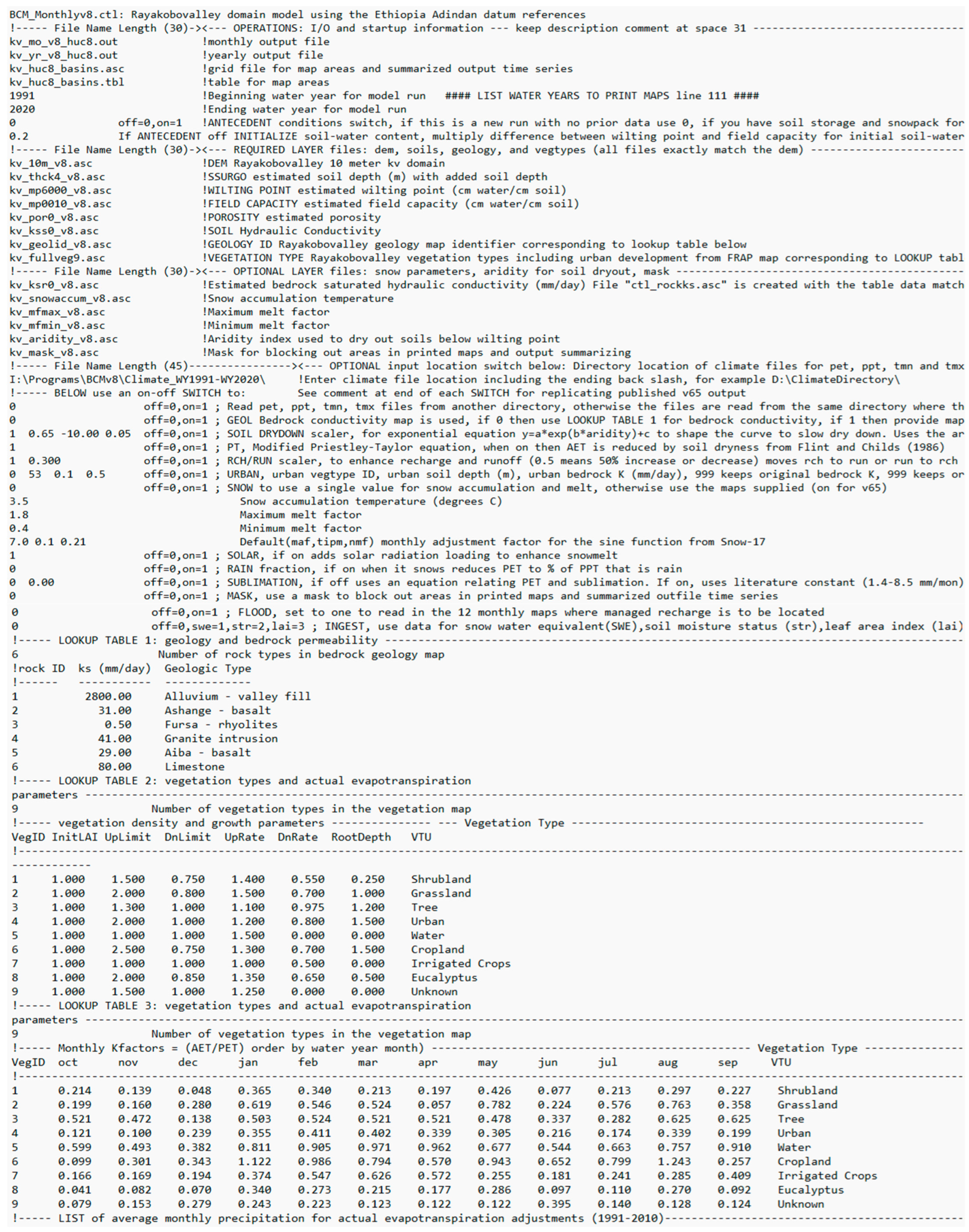
Appendix B
| Vegetation Type | Calibrated Value | |||||
|---|---|---|---|---|---|---|
| InitLAI | UpLimit | DnLimit | UpRate | DnRate | RootDepth | |
| Initial value | 0 to 1 | 1 to 3.5 | 0.5 to 1 | 1 to 2.5 | 0.5 to 1 | 0 to 2.5 |
| Shrubland | 1.00 | 1.50 | 0.75 | 1.40 | 0.55 | 0.25 |
| Grassland | 1.00 | 2.00 | 0.80 | 1.50 | 0.70 | 1.00 |
| Tree | 1.00 | 1.30 | 1.00 | 1.10 | 0.98 | 1.20 |
| Urban | 1.00 | 2.00 | 1.00 | 1.20 | 0.80 | 1.50 |
| Water | 1.00 | 1.00 | 1.00 | 1.50 | 0.00 | 0.00 |
| Cropland | 1.00 | 2.50 | 0.75 | 1.30 | 0.70 | 1.50 |
| Irrigated crops | 1.00 | 1.00 | 1.00 | 1.00 | 0.50 | 0.00 |
| Eucalyptus | 1.00 | 2.00 | 0.85 | 1.35 | 0.65 | 0.50 |
Appendix C
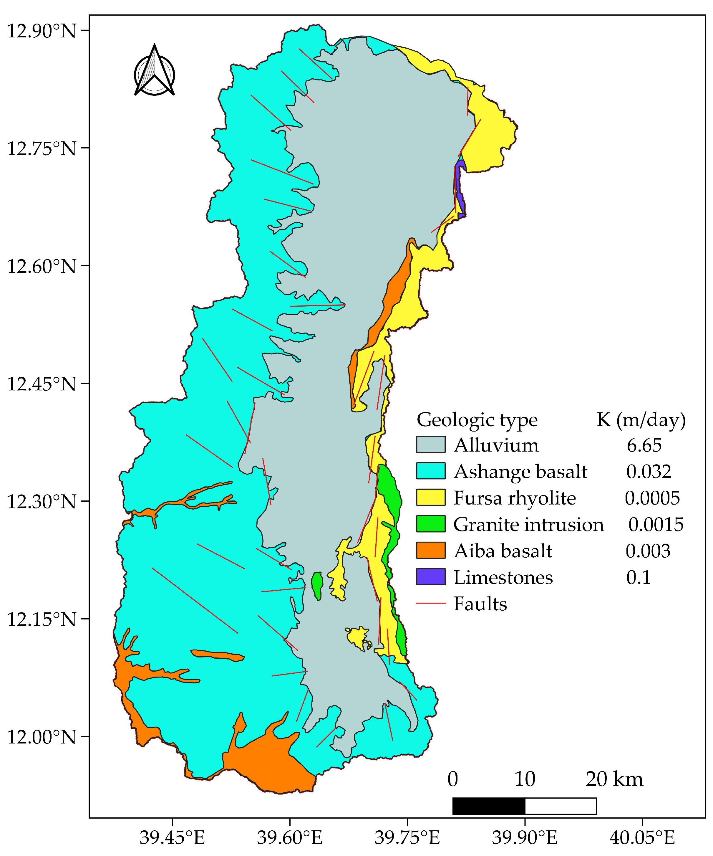
| Geologic Type | Bedrock Conductivity, Ks (m/day) | |
|---|---|---|
| Initial Value | Calibrated Value | |
| Alluvium | 6.65 | 2.8 |
| Ashange basalt | 0.032 | 0.031 |
| Fursa rhyolite | 0.0005 | 0.0005 |
| Granite intrusion | 0.0015 | 0.041 |
| Aiba basalt | 0.003 | 0.029 |
| Limestone | 0.1 | 0.08 |
References
- Adelana, M.; Macdonald, A. Groundwater Research Issues in Africa; CRC Press: Boca Raton, FL, USA, 2008. [Google Scholar]
- Gaye, C.B.; Tindimugaya, C. Review: Challenges and opportunities for sustainable groundwater management in Africa. Hydrogeol. J. 2018, 27, 1099–1110. [Google Scholar] [CrossRef]
- Scanlon, B.R.; Keese, K.E.; Flint, A.L.; Flint, L.E.; Gaye, C.B.; Edmunds, W.M.; Simmers, I. Global synthesis of groundwater recharge in semiarid and arid regions. Hydrol. Process. 2006, 20, 3335–3370. [Google Scholar] [CrossRef]
- Ahmed, A.K.A.; El-Rawy, M.; Ibraheem, A.M.; Al-Arifi, N.; Abd-Ellah, M.K. Forecasting of Groundwater Quality by Using Deep Learning Time Series Techniques in an Arid Region. Sustainability 2023, 15, 6529. [Google Scholar] [CrossRef]
- Uugulu, S.; Wanke, H. Estimation of groundwater recharge in savannah aquifers along a precipitation gradient using chloride mass balance method and environmental isotopes Namibia. Phys. Chem. Earth 2020, 116, 1028844. [Google Scholar] [CrossRef]
- Healy, R.W.; Cook, P.G. Using groundwater levels to estimate recharge. Hydrogeol. J. 2002, 10, 91–109. [Google Scholar] [CrossRef]
- Messerschmid, C.; Aliewi, A. Spatial distribution of groundwater recharge, based on regionalised soil moisture models in Wadi Natuf karst aquifers, Palestine. Hydrol. Earth Syst. Sci. 2022, 26, 1043–1061. [Google Scholar] [CrossRef]
- Dubois, E.; Larocque, M.; Gagné, S.; Meyzonnat, G. Simulation of long-term spatiotemporal variations in regional-scale groundwater recharge: Contributions of a water budget approach in cold and humid climates. Hydrol. Earth Syst. Sci. 2021, 25, 6567–6589. [Google Scholar] [CrossRef]
- Demissie, E.S.; Gashaw, D.Y.; Altaye, A.A.; Demissie, S.S.; Ayele, G.T. Groundwater Recharge Estimation in Upper Gelana Watershed, South-Western Main Ethiopian Rift Valley. Sustainability 2023, 15, 1763. [Google Scholar] [CrossRef]
- Kafando, M.B.; Koïta, M.; Zouré, C.O.; Yonaba, R.; Niang, D. Quantification of Soil Deep Drainage and Aquifer Recharge Dynamics according to Land Use and Land Cover in the Basement Zone of Burkina Faso in West Africa. Sustainability 2022, 14, 14687. [Google Scholar] [CrossRef]
- Hornero, J.; Manzano, M.; Ortega, L.; Custodio, E. Integrating soil water and tracer balances, numerical modelling and GIS tools to estimate regional ground-water recharge: Application to the Alcadozo Aquifer System (SE Spain). Sci. Total Environ. 2016, 568, 415–432. [Google Scholar] [CrossRef]
- Stern, M.A.; Flint, L.E.; Flint, A.L.; Christensen, A.H. A Basin-Scale Approach to Estimating Recharge in the Desert: Anza-Cahuilla Groundwater Basin, CA. J. Am. Water Resour. Assoc. 2021, 57, 990–1003. [Google Scholar] [CrossRef]
- Flint, L.E.; Flint, A.L.; Stern, M.A. The Basin Characterization Model—A Regional Water Balance Software Package, in Techniques and Methods; U.S. Geological Survey: Reston, VA, USA, 2021; p. 85.
- Dripps, W.R.; Bradbury, K.R. A simple daily soil–water balance model for estimating the spatial and temporal distribution of groundwater recharge in temperate humid areas. Hydrogeol. J. 2007, 15, 433–444. [Google Scholar] [CrossRef]
- Healy, R.W. Estimating Groundwater Recharge; Cambridge University Press: Cambridge, UK, 2010. [Google Scholar]
- Jiménez-Martínez, J.; Longuevergne, L.; Le Borgne, T.; Davy, P.; Russian, A.; Bour, O. Temporal and spatial scaling of hydraulic response to recharge in fractured aquifers: Insights from a frequency domain analysis. Water Resour. Res. 2013, 49, 3007–3023. [Google Scholar] [CrossRef]
- Scanlon, B.R.; Cook, P.G. Theme issue on groundwater recharge. Hydrogeol. J. 2002, 10, 3–4. [Google Scholar] [CrossRef]
- Scanlon, B.R.; Healy, R.W.; Cook, P.G. Choosing appropriate techniques for quantifying groundwater recharge. Hydrogeol. J. 2002, 10, 18–39. [Google Scholar] [CrossRef]
- Xie, Y.; Cook, P.G.; Simmons, C.T.; Partington, D.; Crosbie, R.; Batelaan, O. Uncertainty of groundwater recharge estimated from a water and energy balance model. J. Hydrol. 2018, 561, 1081–1093. [Google Scholar] [CrossRef]
- Allison, G.B.; Gee, G.W.; Tyler, S.W. Vadose-Zone Techniques for Estimating Groundwater Recharge in Arid and Semiarid Regions. Soil Sci. Soc. Am. J. 1994, 58, 6–14. [Google Scholar] [CrossRef]
- Flint, L.E.; Flint, A.L.; Thorne, J.H.; Boynton, R. Fine-scale hydrologic modeling for regional landscape applications: The California Basin Characterization Model development and performance. Ecol. Process. 2013, 2, 25. [Google Scholar] [CrossRef]
- Hutchinson, D.G.; Moore, R.D. Throughflow variability on a forested hillslope underlain by compacted glacial till. Hydrol. Process. 2000, 14, 1751–1766. [Google Scholar] [CrossRef]
- Hopp, L.; McDonnell, J. Connectivity at the hillslope scale: Identifying interactions between storm size, bedrock permeability, slope angle and soil depth. J. Hydrol. 2009, 376, 378–391. [Google Scholar] [CrossRef]
- Flint, L.E.; Flint, A.L. Regional Analysis of Ground-Water Recharge, in Professional Paper; Stonestrom, D.A., Ed.; U.S. Geological Survey: Reston, VA, USA, 2007; pp. 29–60.
- Flint, A.L.; Flint, L.E.; Hevesi, J.A.; Blainey, J.B. Fundamental Concepts of Recharge in the Desert Southwest: A Regional Modeling Perspective. In Ground-Water Recharge in a Desert Environment: The Southwestern United States; American Geophysical Union: Washington, DC, USA, 2004; pp. 159–184. [Google Scholar]
- Flint, L.E.; Flint, A.L. Downscaling future climate scenarios to fine scales for hydrologic and ecological modeling and analysis. Ecol. Process. 2012, 1, 2. [Google Scholar] [CrossRef]
- Flint, L.E.; Flint, A.L. Simulation of climate change in San Francisco Bay Basins, California: Case Studies in the Russian River Valley and Santa Cruz Mountains, in Scientific Investigations Report; U.S. Geological Survey: Reston, VA, USA, 2012; p. 61.
- Flint, L.E.; Flint, A.L.; Curtis, J.A.; Delaney, C.; Mendoza, J. Provisional Simulated Unimpaired Mean Daily Streamflow in the Russian River and Upper Eel River Basins, California, Under Historical and Projected Future Climates; U.S. Geological Survey: Reston, VA, USA, 2015.
- Thorne, J.H.; Boynton, R.M.; Flint, L.E.; Flint, A.L. The magnitude and spatial patterns of historical and future hydrologic change in California’s watersheds. Ecosphere 2015, 6, art24. [Google Scholar] [CrossRef]
- Micheli, E.; Dwight Center for Conservation Science at Pepperwood Preserve; Flint, L.; Flint, A.; Weiss, S.; Kennedy, M.; Survey, U.G.; Observation, C.C.F.E. Downscaling Future Climate Projections to the Watershed Scale: A North San Francisco Bay Case Study. San Fr. Estuary Watershed Sci. 2012, 10. [Google Scholar] [CrossRef]
- Hanson, R.T.; Flint, L.E.; Faunt, C.C.; Gibbs, D.R.; Schmid, W. Hydrologic models and analysis of water availability in Cuyama Valley, California. In Scientific Investigations Report; U.S. Geological Survey: Reston, VA, USA, 2014; p. 166. [Google Scholar]
- Faunt, C.C.; Stamos, C.L.; Flint, L.E.; Wright, M.T.; Burgess, M.K.; Sneed, M.; Brandt, J.; Martin, P.; Coes, A.L. Hydrogeology, Hydrologic Effects of Development, and Simulation of Groundwater Flow in the Borrego Valley, San Diego County, California. In Scientific Investigations Report; U.S. Geological Survey: Reston, VA, USA, 2015. [Google Scholar]
- Phillips, S.P.; Rewis, D.L.; Traum, J.A. Hydrologic Model of the Modesto Region, California, 1960–2004. In Scientific Investigations Report; U.S. Geological Survey: Reston, VA, USA, 2015; p. 84. [Google Scholar]
- Siade, A.; Nishikawa, T.; Martin, P. Natural recharge estimation and uncertainty analysis of an adjudicated groundwater basin using a regional-scale flow and subsidence model (Antelope Valley, California, USA). Hydrogeol. J. 2015, 23, 1267–1291. [Google Scholar] [CrossRef]
- Boyce, S.E.; Hanson, R.T.; Ferguson, I.; Schmid, W.; Henson, W.R.; Reimann, T.; Mehl, S.W.; Earll, M.M. One-Water Hydrologic Flow Model: A Modflow Based Conjunctive-Use Simulation Software. In Techniques and Methods; U.S. Geological Survey: Reston, VA, USA, 2020; p. 435. [Google Scholar]
- Boyce, S.E. Modflow One-Water Hydrologic Flow Model (MF-OWHM) Conjunctive Use and Integrated Hydrologic Flow Modeling Software, version 2.3.0.; U.S. Geological Survey: Reston, VA, USA, 2023.
- Byrd, K.B.; Flint, L.E.; Alvarez, P.; Casey, C.F.; Sleeter, B.M.; Soulard, C.E.; Flint, A.L.; Sohl, T.L. Integrated climate and land use change scenarios for California rangeland ecosystem services: Wildlife habitat, soil carbon, and water supply. Landsc. Ecol. 2015, 30, 729–750. [Google Scholar] [CrossRef]
- Stern, M.A.; Flint, L.E.; Flint, A.L. Characterization of hydrology and sediment transport following drought and wildfire in Cache Creek, California. In Proceedings of the SEDHYD, Federal Interagency Sedimentation Conference (FISC) and Federal Interagency Hydrologic Modeling Conference (FIHMC), Reno, NV, USA, 24–28 June 2019. [Google Scholar]
- Flint, L.E.; Flint, A.L.; Stern, M.A.; Mayer, A.; Silver, W.; Franco, F.; Byrd, K.; Sleeter, B.; Alvarez, P.; Creque, J.; et al. Increasing Soil Organic Carbon to Mitigate Greenhouse Gases and Increase Climate Resiliency for California; Cailfornia Natural Resorces Agency: Sacramento, CA, USA, 2018.
- Muñoz-Rojas, M.; Erickson, T.E.; Dixon, K.W.; Merritt, D.J. Soil quality indicators to assess functionality of restored soils in degraded semiarid ecosystems. Restor. Ecol. 2016, 24, S43–S52. [Google Scholar] [CrossRef]
- Weiss, S.; Flint, A.; Flint, L.; Hamilton, H.; Fernandez, M.; Micheli, L. High Resolution Climate-Hydrology Scenarios for San Francisco ’s Bay Area; Dwight Center for Conservation Science at Pepperwood: Santa Rosa, CA, USA, 2013; p. 60. [Google Scholar]
- Hannah, L.; Steele, M.; Fung, E.; Imbach, P.; Flint, L.; Flint, A. Climate change influences on pollinator, forest, and farm interactions across a climate gradient. Clim. Chang. 2016, 141, 63–75. [Google Scholar] [CrossRef]
- Li, W.; An, M.; Wu, H.; An, H.; Huang, J.; Khanal, R. The local coupling and telecoupling of urbanization and ecological environment quality based on multisource remote sensing data. J. Environ. Manag. 2023, 327, 116921. [Google Scholar] [CrossRef]
- Vergara, H.; Hong, Y.; Gourley, J.J.; Anagnostou, E.N.; Maggioni, V.; Stampoulis, D.; Kirstetter, P.-E. Effects of Resolution of Satellite-Based Rainfall Estimates on Hydrologic Modeling Skill at Different Scales. J. Hydrometeorol. 2014, 15, 593–613. [Google Scholar] [CrossRef]
- Gourley, J.J.; Vieux, B.E. A Method for Evaluating the Accuracy of Quantitative Precipitation Estimates from a Hydrologic Modeling Perspective. J. Hydrometeorol. 2005, 6, 115–133. [Google Scholar] [CrossRef]
- Lewis, F.; Walker, G. Assessing the potential for episodic recharge in south-western Australia using rainfall data. Hydro. Geol. J. 2002, 10, 229–237. [Google Scholar]
- Ackerly, D.D.; Loarie, S.R.; Cornwell, W.K.; Weiss, S.B.; Hamilton, H.; Branciforte, R.; Kraft, N.J.B. The geography of climate change: Implications for conservation biogeography. Divers. Distrib. 2010, 16, 476–487. [Google Scholar] [CrossRef]
- Franklin, J.; Davis, F.W.; Ikegami, M.; Syphard, A.D.; Flint, L.E.; Flint, A.L.; Hannah, L. Modeling plant species distributions under future climates: How fine scale do climate projections need to be? Glob. Chang. Biol. 2013, 19, 473–483. [Google Scholar] [CrossRef]
- Tafesse, N.; Nedaw, D.; Woldearegay, K.; Gebreyohannes, T.; Steenbergen, F.V. Groundwater management for irrigation in the raya and kobo valleys, Northern Ethiopia. Int. J. Earth Sci. Eng. 2015, 8, 1104–1114. [Google Scholar]
- Corti, G.; Bastow, I.D.; Keir, D.; Pagli, C.; Baker, E. Rift-Related Morphology of the Afar Depression. In Landscapes and Landforms of Ethiopia. World Geomorphological Landscapes; Billi, P., Ed.; Springer: Dordrecht, The Netherlands, 2015; pp. 251–274. [Google Scholar] [CrossRef]
- Zwaan, F.; Corti, G.; Keir, D.; Sani, F. A review of tectonic models for the rifted margin of Afar: Implications for continental break-up and passive margin formation. J. Afr. Earth Sci. 2019, 164, 103649. [Google Scholar] [CrossRef]
- Harris, I.; Osborn, T.J.; Jones, P.; Lister, D. Version 4 of the CRU TS monthly high-resolution gridded multivariate climate dataset. Sci. Data 2020, 7, 1–18. [Google Scholar] [CrossRef]
- Renard, D.; Tilman, D. National food production stabilized by crop diversity. Nature 2019, 571, 257–260. [Google Scholar] [CrossRef]
- Nalder, I.A.; Wein, R.W. Spatial interpolation of climatic Normals: Test of a new method in the Canadian boreal forest. Agric. For. Meteorol. 1998, 92, 211–225. [Google Scholar] [CrossRef]
- Bouwer, L.M.; Aerts, J.C.J.H.; Coterlet, G.V.D.; Giesen, N.V.D.; Gieske, A.; Mannaerts, C. Evaluating Downscaling Methods for Preparing Global Circulation Model (GCM) Data for Hydrological Impact Modelling. In Climate Change in Contrasting River Basins Adaptation Strategies for Water, Food and Environment; CABI Publishing: Wallingford, UK, 2004; pp. 25–47. [Google Scholar]
- Thorne, J.H.; Zboynton, R.; Flint, L.; Flint, A.; Lee, T. Development and Application of Downscaled Hydroclimatic Predictor Variables for Use in Climate Vulnera-Bility and Assessment Studies; University of California: Davis, CA, USA, 2012. [Google Scholar]
- Flint, A.L.; Childs, S.W. Use of the Priestley-Taylor evaporation equation for soil water limited conditions in a small forest clearcut. Agric. For. Meteorol. 1991, 56, 247–260. [Google Scholar] [CrossRef]
- Blatchford, M.L.; Mannaerts, C.M.; Njuki, S.M.; Nouri, H.; Zeng, Y.; Pelgrum, H.; Wonink, S.; Karimi, P. Evaluation of WaPOR V2 evapotranspiration products across Africa. Hydrol. Process. 2020, 34, 3200–3221. [Google Scholar] [CrossRef]
- Dile, Y.T.; Ayana, E.K.; Worqlul, A.W.; Xie, H.; Srinivasan, R.; Lefore, N.; You, L.; Clarke, N. Evaluating satellite-based evapotranspiration estimates for hydrological applications in data-scarce regions: A case in Ethiopia. Sci. Total. Environ. 2020, 743, 140702. [Google Scholar] [CrossRef]
- Gebremedhin, M.A.; Lubczynski, M.W.; Maathuis, B.H.; Teka, D. Deriving potential evapotranspiration from satellite-based reference evapotranspiration, Upper Tekeze Basin, Northern Ethiopia. J. Hydrol. Reg. Stud. 2022, 41, 101059. [Google Scholar] [CrossRef]
- Abate, B.Z.; Assefa, T.T.; Tigabu, T.B.; Abebe, W.B.; He, L. Hydrological Modeling of the Kobo-Golina River in the Data-Scarce Upper Danakil Basin, Ethiopia. Sustainability 2023, 15, 3337. [Google Scholar] [CrossRef]
- Wang, Y.; Zhang, S.; Chang, X. Evapotranspiration Estimation Based on Remote Sensing and the SEBAL Model in the Bosten Lake Basin of China. Sustainability 2020, 12, 7293. [Google Scholar] [CrossRef]
- Waqas, M.M.; Waseem, M.; Ali, S.; Leta, M.K.; Shah, A.N.; Awan, U.K.; Shah, S.H.H.; Yang, T.; Ullah, S. Evaluating the Spatio-Temporal Distribution of Irrigation Water Components for Water Resources Management Using Geo-Informatics Approach. Sustainability 2021, 13, 8607. [Google Scholar] [CrossRef]
- Weerasinghe, I.; Bastiaanssen, W.; Mul, M.; Jia, L.; Van Griensven, A. Can we trust remote sensing ET products over Africa? Hydrol. Earth Syst. Sci. Discuss. 2019, 24, 1565–1586. [Google Scholar] [CrossRef]
- Chukalla, A.D.; Mul, M.L.; van der Zaag, P.; van Halsema, G.; Mubaya, E.; Muchanga, E.; Besten, N.D.; Karimi, P. A framework for irrigation performance assessment using WaPOR data: The case of a sugarcane estate in Mozambique. Hydrol. Earth Syst. Sci. 2022, 26, 2759–2778. [Google Scholar] [CrossRef]
- QGIS Development Team. QGIS Geographic Information System; Open Source Geospatial Foundation: Beaverton, OR, USA, 2009. [Google Scholar]
- Nash, J.E.; Sutcliffe, J.V. River flow forecasting through conceptual models part I—A discussion of principles. J. Hydrol. 1970, 10, 282–290. [Google Scholar] [CrossRef]
- Moriasi, D.N.; Arnold, J.G.; van Liew, M.W.; Bingner, R.L.; Harmel, R.D.; Veith, T.L. Model evaluation guidelines for systematic quantification of accuracy in watershed simulations. Trans. ASABE 2007, 50, 885–900. [Google Scholar] [CrossRef]
- Legates, D.; McCabe, G. Evaluating the Use Of “Goodness-of-Fit” Measures in Hydrologic and Hydroclimatic Model Validation. Water Resour. Res. 1999, 35, 233–241. [Google Scholar] [CrossRef]
- Gupta, H.V.; Sorooshian, S.; Yapo, P.O. Status of Automatic Calibration for Hydrologic Models: Comparison with Multilevel Expert Calibration. J. Hydrol. Eng. 1999, 4, 135–143. [Google Scholar] [CrossRef]
- Markovich, K.H.; Manning, A.H.; Condon, L.E.; McIntosh, J.C. Mountain-Block Recharge: A Review of Current Understanding. Water Resour. Res. 2019, 55, 8278–8304. [Google Scholar] [CrossRef]
- Wilson, J.L.; Guan, H. Mountain-Block Hydrology and Mountain-Front Recharge. In Groundwater Recharge in a Desert Environment: The Southwestern United States; American Geophysical Union: Washington, DC, USA, 2004; pp. 113–137. [Google Scholar]
- Dar, T.; Rai, N.; Kumar, S. Distinguishing Mountain Front and Mountain Block Recharge in an Intermontane Basin of the Himalayan Region. Groundwater 2022, 60, 488–495. [Google Scholar] [CrossRef]
- Kim, J.H.; Jackson, R.B. A Global Analysis of Groundwater Recharge for Vegetation, Climate, and Soils. Vadose Zone J. 2012, 11, 0021RA. [Google Scholar] [CrossRef]
- Nolan, B.T.; Healy, R.W.; Taber, P.E.; Perkins, K.; Hitt, K.J.; Wolock, D.M. Factors influencing ground-water recharge in the eastern United States. J. Hydrol. 2007, 332, 187–205. [Google Scholar] [CrossRef]
- Flint, L.E.; Flint, A.L.; Stolp, B.J.; Danskin, W.R. A basin-scale approach for assessing water resources in a semiarid environment: San Diego region, California and Mexico. Hydrol. Earth Syst. Sci. 2012, 16, 3817–3833. [Google Scholar] [CrossRef]
- Skrzypek, G.; Siller, A.; McCallum, J.L.; Dogramaci, S. Groundwater recharge through internally drained basins in a semiarid climate, Western Australia. J. Hydrol. Reg. Stud. 2023, 47, 101388. [Google Scholar] [CrossRef]
- Gebru, T.A.; Tesfahunegn, G.B. GIS based water balance components estimation in northern Ethiopia catchment. Soil Tillage Res. 2019, 197, 104514. [Google Scholar] [CrossRef]
- Dereje, B.; Nedaw, D. Groundwater Recharge Estimation Using WetSpass Modeling in Upper Bilate Catchment, Southern Ethiopia. Momona Ethiop. J. Sci. 2019, 11, 37–51. [Google Scholar] [CrossRef]
- Yenehun, A.; Dessie, M.; Nigate, F.; Belay, A.S.; Azeze, M.; Van Camp, M.; Taye, D.F.; Kidane, D.; Adgo, E.; Nyssen, J.; et al. Spatial and temporal simulation of groundwater recharge and cross-validation with point estimations in volcanic aquifers with variable topography. J. Hydrol. Reg. Stud. 2022, 42, 101142. [Google Scholar] [CrossRef]
- Hanson, R.T.; Ritchie, A.B.; Boyce, S.E.; Ferguson, I.; Galanter, A.E.; Flint, L.E.; Henson, W.R. Rio Grande Transboundary Integrated Hydrologic Model and Water-Availability Analysis, New Mexico and Texas, United States, and Northern Chihuahua, Mexico, in Scientific Investigations Report; U.S. Geological Survey: Reston, VA, USA, 2020; p. 186.

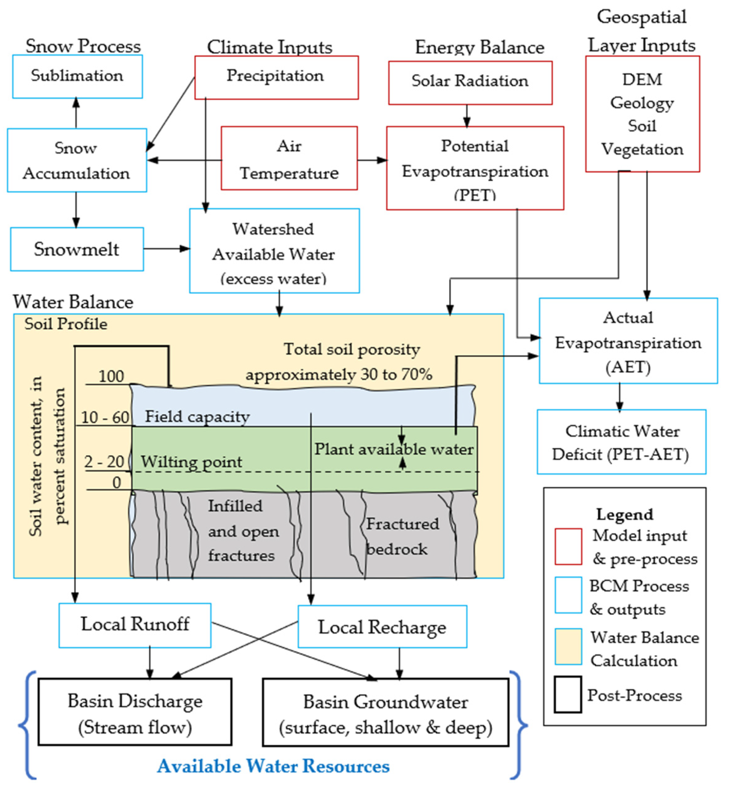
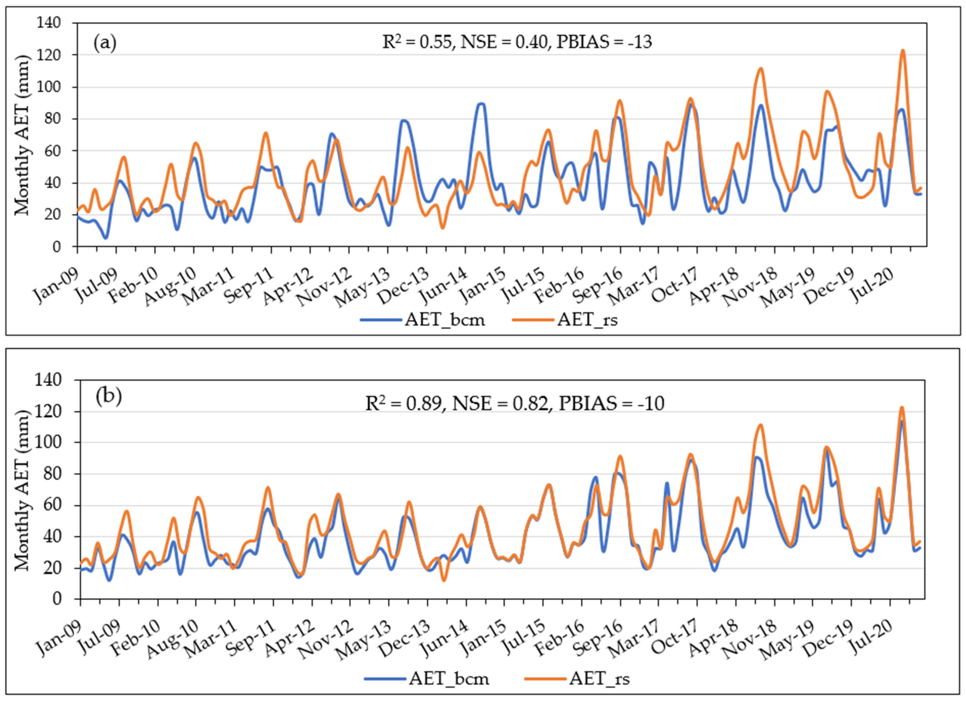


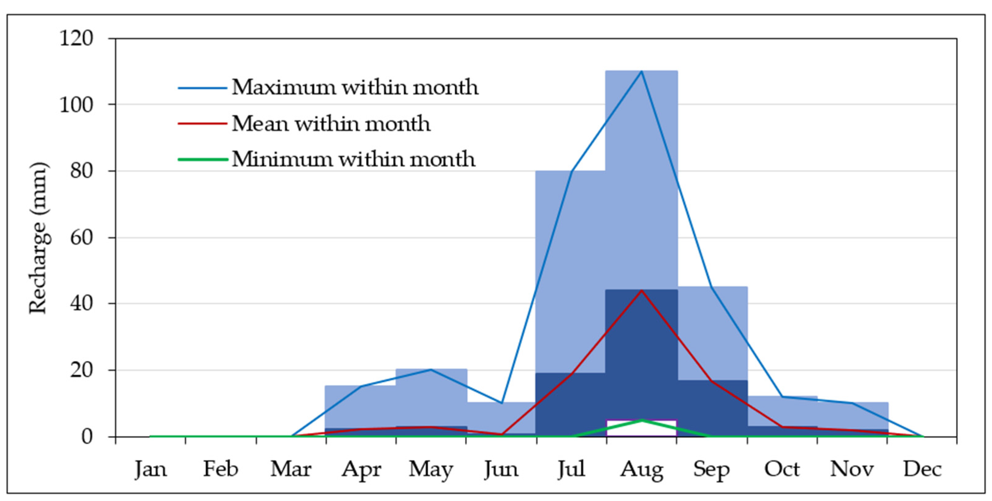
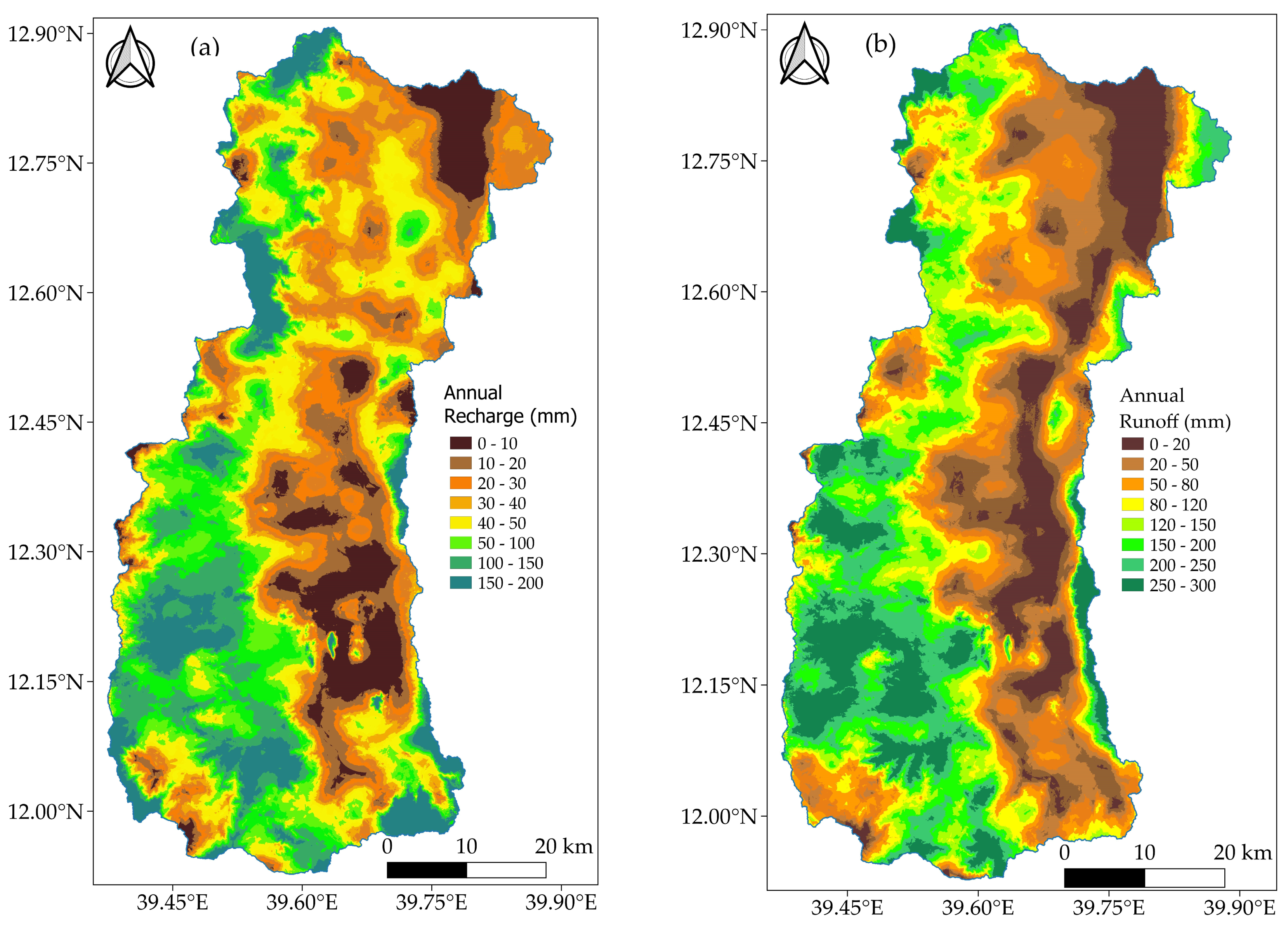
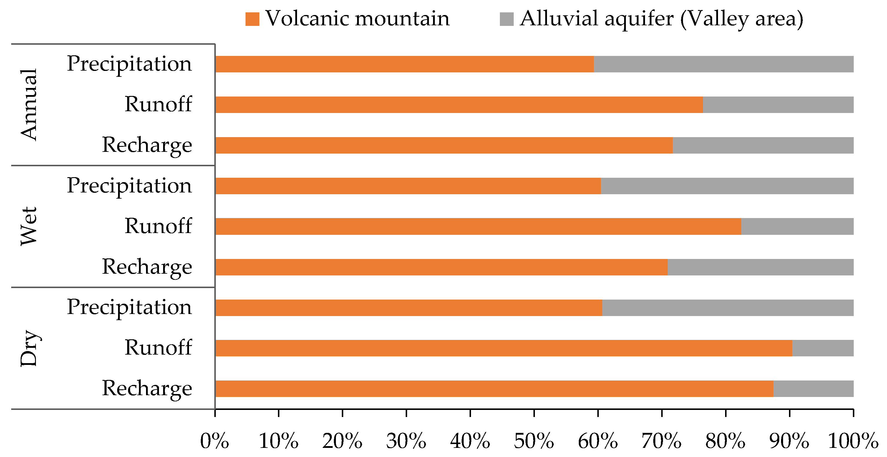
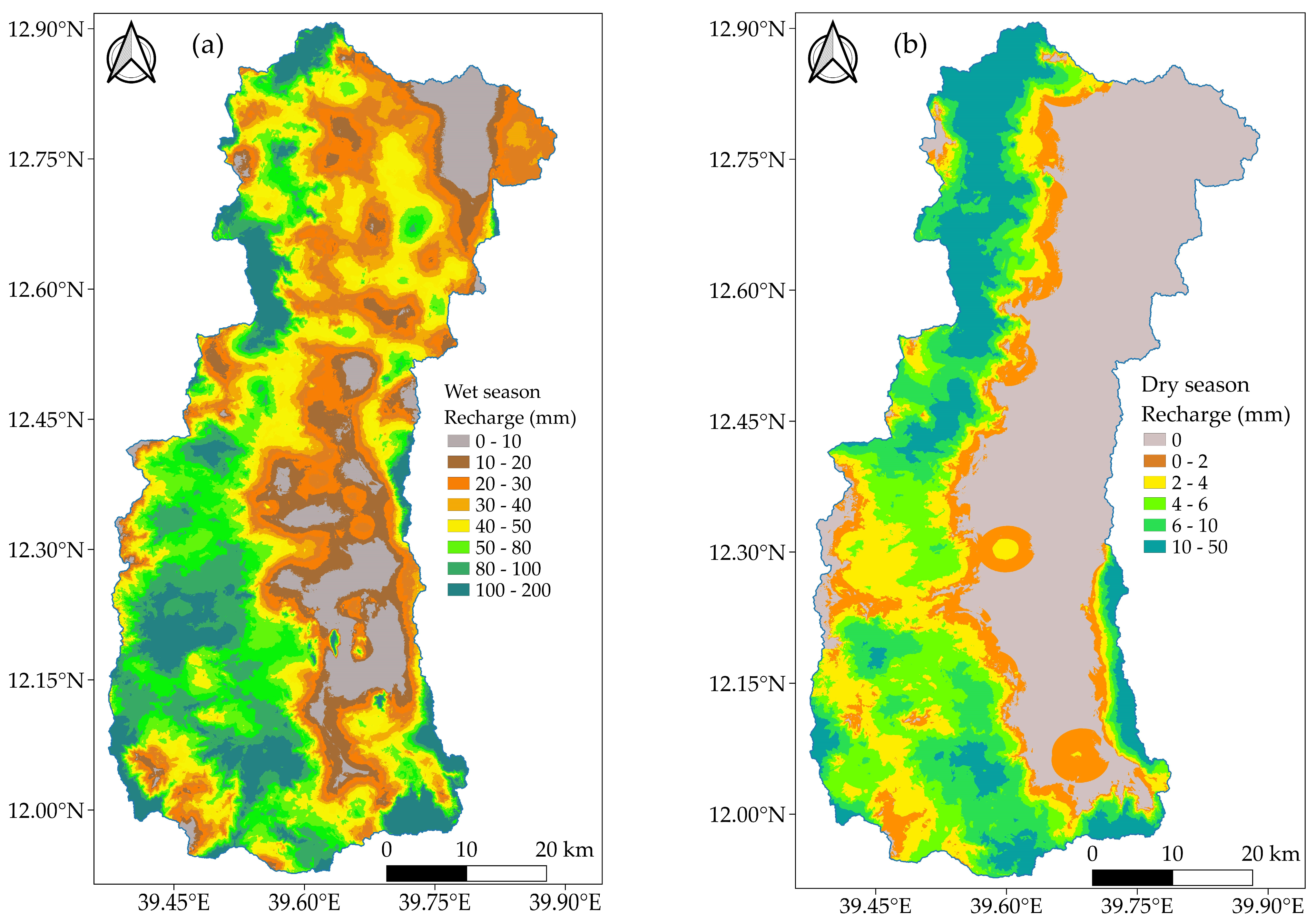
| Variable | Source | Type | Description |
|---|---|---|---|
| Climate datasets (maximum and minimum air temperature and precipitation (PCP)) | Climatic Research Unit transient monthly dataset | Model input | Maximum and minimum monthly air temperature (°C) and total monthly precipitation (mm) |
| Potential evapotranspiration (PET) | Modeled (pre-processed) | Model input | Total amount of water that can evaporate from ground surface and transpire from plant bodies (mm) |
| Digital elevation model (DEM) | USGS | Model input | Raster representation of ground surface elevation data |
| Geology (GEOL) | MoWE and CDSWC | Model input | Geology types with bedrock conductivity values (Ks, mm/day). |
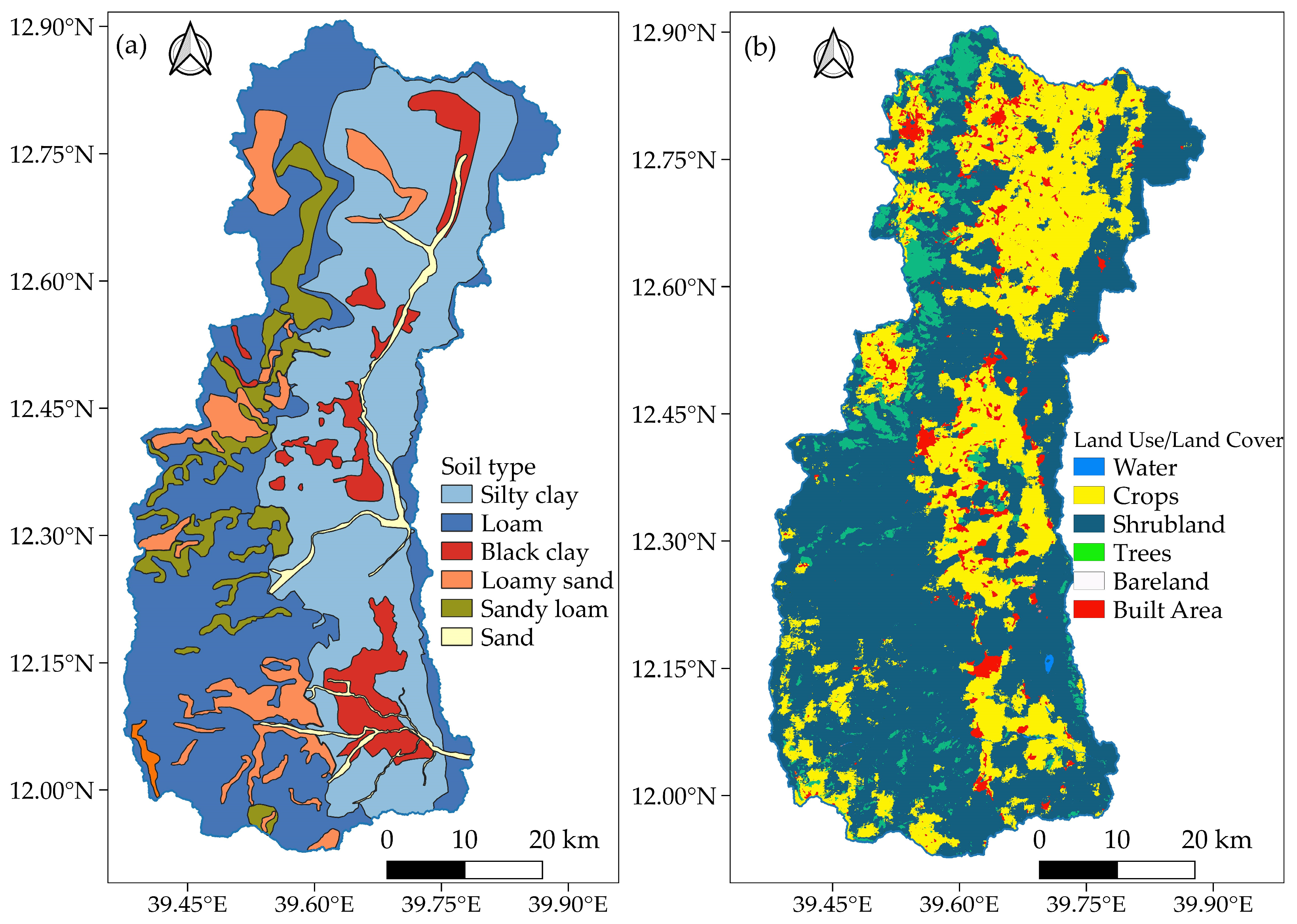
| Soil (SOL) | MoWE and CDSWC | Model input | Soil data with properties (soil depth (m), porosity (m/m), saturated hydraulic conductivity (mm/day), water content at field capacity (m water/m soil), and permanent wilting point (m water/m soil)) |
| Vegetation (VEG) | MoWE and CDSWC | Model input | Vegetation types with density and growth parameters and monthly crop coefficient values (Kc) |
| Excess water (EXC) | BCM | Model output | Amount of water remaining in the system, mm (PCP-PET) |
| Soil water storage (STR) | BCM | Model output | Average amount of water stored in the soil (mm) |
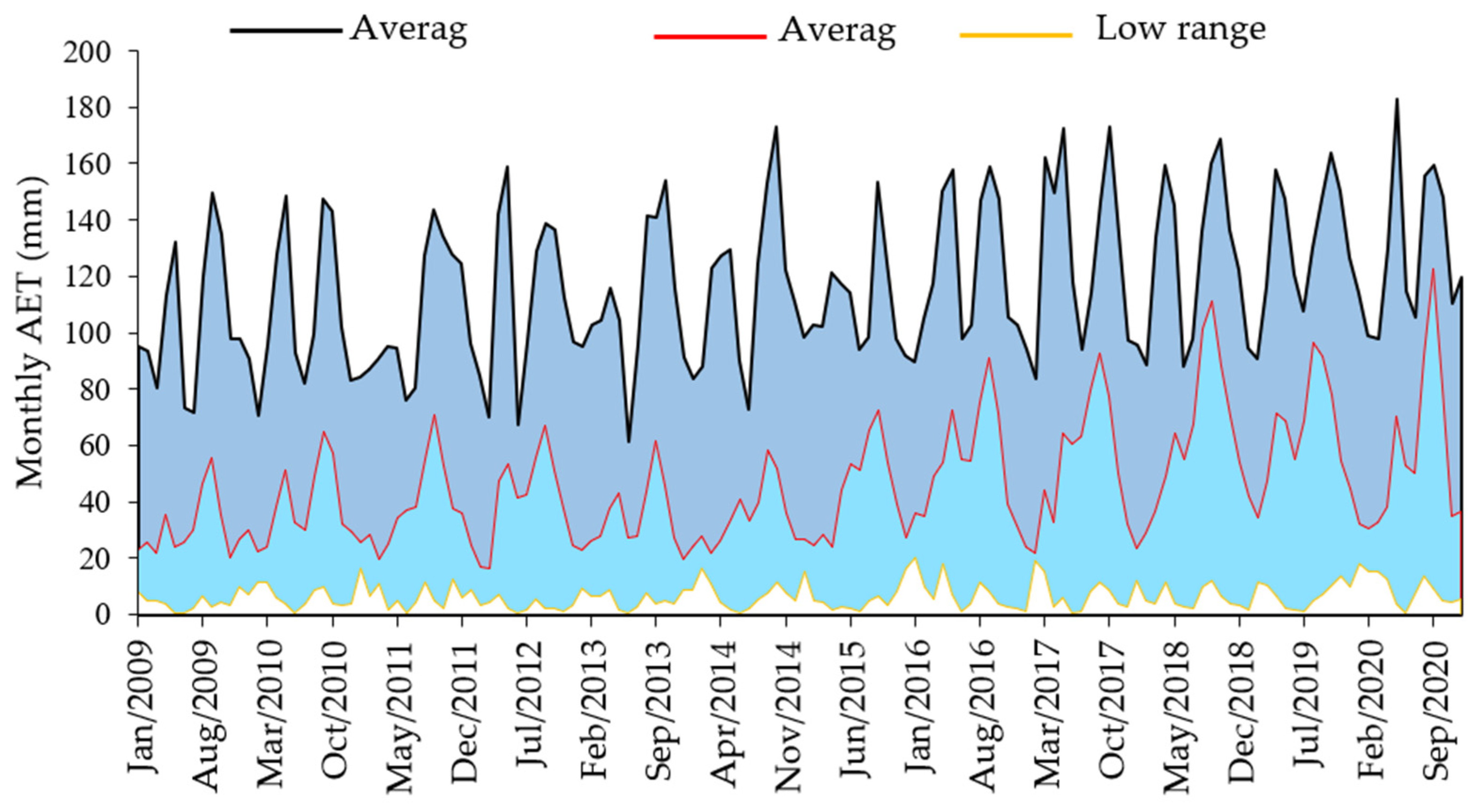
| Actual evapotranspiration (AET) | BCM | Model output | Amount of water that evaporates and transpires that is available in soil water storage above wilting point (mm) |
| Climatic water deficit (CWD | BCM | Model output | Evaporative demand not met by available water, mm (a measure of how much more water could have been evaporated or transpired from a site covered by a standard crop, had that water been available, PET-AET) |
| Runoff (RUN) | BCM | Model output | Amount of water that becomes runoff, mm (amount of water that exceeds total storage + rejected recharge) |
| Recharge (RCH) | BCM | Model output | Amount of water that penetrates below the root zone, mm (infiltration that reaches the water table and changes the amount of water in saturated storage) |
| Performance Measures | Calibration | Validation |
|---|---|---|
| R2 | 0.83 | 0.78 |
| NSE | 0.78 | 0.75 |
| PBIAS | 2.28 | 8.34 |
| Parameter | Kobo and Raya (Area = 3506 km2) | Volcanic Mountain (Western Part, Area = 2042 km2) | Alluvial Aquifer (Valley Area, Area = 1464 km2) | |
|---|---|---|---|---|
| Annual | Precipitation | 799.28 | 920.54 | 630.14 |
| Recharge | 73.32 | 98.12 | 38.72 | |
| Runoff | 167.22 | 235.22 | 72.37 | |
| Wet | Precipitation | 479.99 | 561.00 | 367.00 |
| Recharge | 59.23 | 78.61 | 32.21 | |
| Runoff | 137.29 | 204.5 | 43.51 | |
| Dry | Precipitation | 312.13 | 366.00 | 237.00 |
| Recharge | 14.39 | 22.41 | 3.21 | |
| Runoff | 30.26 | 48.28 | 5.12 |
Disclaimer/Publisher’s Note: The statements, opinions and data contained in all publications are solely those of the individual author(s) and contributor(s) and not of MDPI and/or the editor(s). MDPI and/or the editor(s) disclaim responsibility for any injury to people or property resulting from any ideas, methods, instructions or products referred to in the content. |
© 2023 by the authors. Licensee MDPI, Basel, Switzerland. This article is an open access article distributed under the terms and conditions of the Creative Commons Attribution (CC BY) license (https://creativecommons.org/licenses/by/4.0/).
Share and Cite
Mekonen, S.S.; Boyce, S.E.; Mohammed, A.K.; Flint, L.; Flint, A.; Disse, M. Recharge Estimation Approach in a Data-Scarce Semi-Arid Region, Northern Ethiopian Rift Valley. Sustainability 2023, 15, 15887. https://doi.org/10.3390/su152215887
Mekonen SS, Boyce SE, Mohammed AK, Flint L, Flint A, Disse M. Recharge Estimation Approach in a Data-Scarce Semi-Arid Region, Northern Ethiopian Rift Valley. Sustainability. 2023; 15(22):15887. https://doi.org/10.3390/su152215887
Chicago/Turabian StyleMekonen, Sisay S., Scott E. Boyce, Abdella K. Mohammed, Lorraine Flint, Alan Flint, and Markus Disse. 2023. "Recharge Estimation Approach in a Data-Scarce Semi-Arid Region, Northern Ethiopian Rift Valley" Sustainability 15, no. 22: 15887. https://doi.org/10.3390/su152215887
APA StyleMekonen, S. S., Boyce, S. E., Mohammed, A. K., Flint, L., Flint, A., & Disse, M. (2023). Recharge Estimation Approach in a Data-Scarce Semi-Arid Region, Northern Ethiopian Rift Valley. Sustainability, 15(22), 15887. https://doi.org/10.3390/su152215887


