Article

Analyzing Community Perception of Protected Areas to Effectively Mitigate Environmental Risks Using Qualitative Comparative Analysis: The Case of Savu Sea National Marine Park, East Nusa Tenggara, Indonesia

by
Chaterina Agusta Paulus
1,*,
Akhmad Fauzi
2 and
Damianus Adar
3
1
Department of Aquatic Resource Management, Nusa Cendana University, Kupang 85001, Indonesia
2
Regional and Rural Development Planning, Bogor Agricultural University, Bogor 16680, Indonesia
3
Department of Agribusiness, Nusa Cendana University, Kupang 85001, Indonesia
*
Author to whom correspondence should be addressed.
Sustainability 2023, 15(23), 16498; https://doi.org/10.3390/su152316498
Submission received: 12 September 2023 / Revised: 24 November 2023 / Accepted: 28 November 2023 / Published: 1 December 2023
(This article belongs to the Special Issue Resilience to Environmental Risks)

Abstract

:
The Savu Sea holds significant importance as a conservation area in Indonesia that provides sustenance and livelihoods for local communities. However, the sea is currently facing various threats, including overfishing, pollution, and the impacts of climate change. Therefore, the effective management of this conservation area relies heavily on the active participation of local communities. This study aims to address the research question “What combination of variables leads to the positive outcome of strong participation and could thus mitigate environmental risk?” These variables include the socio-economic condition of coastal households, environmental awareness, the existence of community-based conservation areas, attitudes towards activities within the conservation area, and participation in multi-stakeholder institutions. This study employs the crisp-set Qualitative Comparative Analysis (QCA) or csQCA methods. A survey was conducted among 22 coastal villages surrounding the Savu Sea, resulting in the identification of 14 different combinations of pathways that contribute to varying levels of perception regarding conservation. Of these 14 pathways, 10 were found to lead to the positive outcome of strong participation. Valuable lessons can be drawn from this study to enhance the design of policies aimed at effectively managing the Savu conservation area.

1. Introduction

The Savu Sea is an important ecosystem and livelihood resource for the people of Indonesia. It provides a home for a variety of marine life, including fish, coral reefs, and mangroves. These ecosystems support a wide range of economic activities, such as fishing, tourism, and coastal agriculture. The Savu Sea is also important for the environment. It helps to regulate the climate; protect habitats; protect the ecosystem structure, function, and integrity; enhance species diversity, richness, size, and density; and provide a habitat for endangered species. However, the Savu Sea is facing a number of threats, including pollution, overfishing, and climate change. These threats could have a devastating impact on the livelihoods and environment of the region. To address this issue, the Indonesian government established The Savu Sea National Marine Park in 2009 to protect the rich marine life and ecosystems of the Savu Sea. The park covers an area of 3.5 million ha and includes a variety of habitats, such as coral reefs, mangroves, and seagrass beds. The Savu Sea National Marine Park (NMP), which is part of the Lesser Sunda Eco-Region, is recorded to have a total of 532 coral species, with 11 endemic and sub-endemic species. Coral reefs in the Savu Sea NMP are found scattered in coastal waters in all the regencies included in the Savu Sea NMP area, with a total area of 63,339.32 ha [1]. There are 22 species of marine mammals in the waters of the Savu Sea NMP, consisting of 14 species of whale, 7 species of dolphin, and 1 species of dugong [2].
Although the Savu Sea is an important ecosystem and livelihood resource protected by NMP legislation, achieving the protection goals requires local stakeholder involvement. However, no study has yet been conducted on the impact of stakeholder engagement on the NMP’s ability to mitigate risks to the community, prevent pollution, and protect ecosystems. As a result, the current management of the NMP may not be effective, and these risks may continue to pose a threat to the Savu Sea. Studies have shown that the average damage to these coastal ecosystems reaches 70% [1]. Increasing pressures and the use of destructive practices threaten the sustainability of shallow marine ecosystems in the Savu Sea.
The risks that arise in the absence of marine conservation measures include the degradation of natural resources, pollution, and the absence of spillover effects from marine protected areas. All of these risks can disrupt the livelihoods and welfare of coastal communities [3,4,5,6,7,8,9,10,11,12,13,14,15,16]. Community participation in conservation, especially in marine protected areas, is critical to its success. Understanding the environmental risks associated with activities in marine protected areas is important to reduce harm [17]. To avoid these risks, it is not sufficient to build public awareness of the importance of maintaining coastal ecosystems. Thus, concrete actions via long-term planning should be established with regard to sustainable marine resource management for the resilience of coastal communities in the face of other global environmental risks, such as climate change [9]. This led us to wonder how the socio-economic conditions of coastal communities and other factors such as knowledge and involvement in community activities could lead to an increased awareness of protected areas and to wonder which combination of such factors contributes to an increase in the strong perception of the conservation area. This research aims to explore how community perceptions can increase the awareness of environmental damage resulting from the existence of marine protected areas as a means of risk mitigation.
The survey conducted in the coastal villages surrounding the Savu Sea in the East Nusa Tenggara (ENT) Province aimed to determine the factors that influence community perceptions regarding the significance of maintaining marine protected areas as a means of mitigating environmental and natural resource risks, as well as sustaining their livelihoods and the overall ecosystem’s social and economic sustainability. The assessment of this perception is necessary because the mere presence of spillover effects and increased community ownership rights does not guarantee the effective management and long-term sustainability of marine protected areas. The potential benefits of spillover will not be realized without the active participation of the community and government. This can be achieved more effectively and rapidly with the full support of the government, through raising public awareness of the environmental risks faced by the Savu Sea’s marine protected area.
This study is the first to assess the perception of conservation from the stakeholder point of view, especially in the case of the Savu Sea. This study used a novel approach of complex causality, instead of linear causality. This involved linear regression, which is normally used to determine the factors affecting strong perceptions in the conservation area. Previous research on the Savu Sea, such as that conducted by Harkness [18], has explored the livelihood of the coastal communities of the Savu Sea using descriptive analysis. Similarly, Turisno et al. [19] used normative descriptive analyses to analyze the role of local wisdom in relation to the conservation of the Savu Sea.

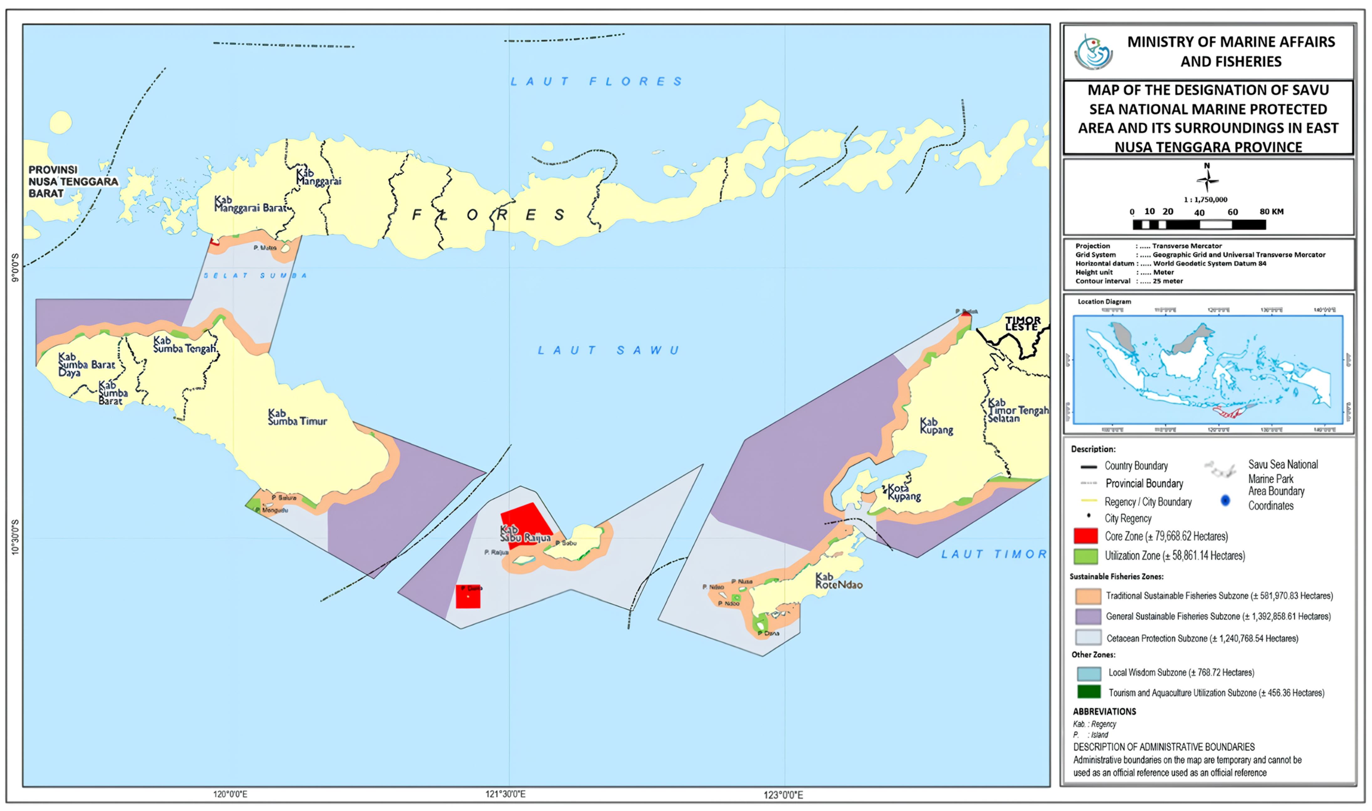
2. Brief Description of the Savu Sea

2.1. When Was the Savu Sea NMP Established and Why?

(1)
The establishment of the Savu Sea NMP
The Savu Sea NMP is a national marine protected area established in 2014 based on the Decree of the Minister of Marine Affairs and Fisheries Number 5 of 2014, with an area of 3,355,352.82 ha. The Savu Sea NMP is located in the ENT Province, Indonesia, and is the largest marine protected area in the World’s Coral Triangle region. It covers only 2% of the world’s marine area but contains approximately 76% of the world’s coral reef species and 37% of the world’s reef fish species [1]. The Savu Sea is a migration site for 14 of the world’s 27 cetacean species, including rare blue whales (Balaenoptera musculus) and sperm whales (Physeter macrocephalus) [20,21]. It is home to 4 species of sea turtles, 336 species of fish, and 500 species of coral [1]. The Savu Sea has a wide range of coral reef cover, with high species biodiversity and deep-sea habitats that support cetacean diversity. Most of the beaches in this region have been identified as nesting sites for sea turtles, which are listed as endangered and threatened in the International Union for the Conservation of Nature (IUCN) Red Data Book and the Convention on International Trade in Endangered Species of Wild Fauna and Flora (CITES).
(2)
The purpose of establishing the Savu Sea NMP
The Savu Sea, a central area of the NMP that has been reserved as a marine protected area, contains a high diversity of fisheries and other marine resources. This situation needs to be maintained so that its biodiversity is sustainable and its economic and ecological functions continue to run well. Apart from its biodiversity, the Savu Sea also plays an important role as Indonesia’s outermost boundary with other countries. The establishment of the Savu Sea as a national marine protected area (Savu Sea NMP) was implemented with the aim of realizing the preservation and management of fish resources and ecosystems as part of the ecological region of the Lesser Sunda Marine Eco-Region. It is thus a frame of reference for regional development in fisheries, tourism, coastal communities, shipping, science, and conservation, as well improvements in the welfare of coastal communities through sustainable livelihoods [1,10,11,22].

2.2. Management Authorities

The National Marine Conservation Area Office in Kupang (BKKPN), the capital city of East Nusa Tenggara, is a technical implementation unit under the Directorate General of Marine Spatial Management. The technical implementation unit, under the Directorate General of Marine Spatial Management, Ministry of Maritime Affairs and Fisheries (MMAF), has duties and functions in the management, utilization, and supervision of marine protected areas, one of which is the Savu Sea NMP. The management of the conservation area is carried out with a zoning system to regulate activities in the area of the national marine protected area, so that it remains in accordance with the conservation methods [1,22]. The zoning is divided into three main zones: the core zone, the utilization zone, and the sustainable fisheries zone (Figure 1).

2.3. The Role of the Savu Sea NMP in Ecology, Economy, and Society

(1)
Ecology
The waters of the Savu Sea are very dynamic and represent a meeting of two large mass currents: (1) water masses from the Indian Ocean and (2) the Banda Sea. The phenomenon of the upwelling or stirring of cold deep sea water masses and warm surface water grants the water of this area very high productivity. Therefore, some species of whale reside in this sea. Oceanographically, the area has notoriously strong ocean currents. Water depths of up to 4000 m and steep cliffs are the dominant characteristics of the seascape in the Savu Sea. The wind patterns in the Western season period (December to February) are dominated by westerly winds that blow the strongest in December. The Savu Sea waters have a mixed semidiurnal tidal cycle that leans towards double daily tides, where in one day there are two high tides and two low tides [1].
The results of monitoring conducted on coral reef conditions in 2019 at 15 observation locations scattered throughout the conservation area show that, in general, the condition of the Savu Sea NMP coral reefs varies from very bad to moderate [22]. The condition of coral reefs in the very bad category is 27%, the condition of coral reefs in the bad category is 46%, and the condition of coral reefs in the moderate category is 27% [4,23]. A positive trend can be observed from year to year regarding the abundance of reef fish in the Savu Sea NMP. The total number of reef fish individuals from the Chaetodontidae family found in 2019 was 815, consisting of 27 species. The most dominant reef fish species were Chaetodon klenii, Chaetodon vagabundus, and Chaetodon trifascialis. The target fish group is a fish with high economic value and a target of the fishing business. The target fish species found are fish from the Acanthuridae, Serranidae, Lutjanidae, Lethrinidae, Nemipteridae, Mullidae, Kyphosidae, and Carangidae families [22].
The Savu Sea NMP is home to six species of sea turtle in Indonesia. The types of sea turtle found are green turtle (Chelonia mydas), hawksbill turtle (Eretmochelys imbricata), olive ridley sea turtle (Lepidochelys olivacea), leatherback sea turtle (Dermochelys coriacea), flatback sea turtle (Natator depressus), and loggerhead turtle (Caretta caretta) [22]. Sea urchins in the Savu Sea NMP have a fairly wide distribution and are found in almost all areas. There are eight benthos species from three family groups, namely Echinodermata (Acanthaster planci, Diadema sp., Linkia laevigata, and Cucumber), Crustacea (Lobster), and Mollusca (Drupella, Tridacna, and Trochus). The average abundance of benthos in the Savu Sea NMP is 0.18 Ind/m2 [22]. Seagrass beds in the Savu Sea NMP area are most commonly found in the waters of the East Sumba Regency, Sabu Raijua Regency, and Rote Ndao Regency, which are included in 10 species out of a total of 13 species in Indonesia. The total area of seagrass beds in the Savu Sea NMP is 5320.62 ha [22]. Mangrove forests in the ENT consist of approximately 9 families divided into 15 species. The area of mangrove forests in the Savu Sea NMP area is 5019.53 ha, with the largest mangrove areas located in the regencies of East Sumba and Rote Ndao. Mangrove tree density varies between 900 and 2367 ind/ha, with a percentage of canopy cover in the tight category (>75%) [22].
(2)
Economy and Society
The archipelagic nature of the ENT means that many people in this province live in coastal areas. The majority of their livelihoods are as fishermen and seaweed farmers. The income of seaweed farmers from seaweed sales varies from one region to another, influenced by water conditions and the length of the planting period. In 2019, wet seaweed production was recorded to be 2.4 million tons, with a value of Indonesian rupiah (IDR) 4.7 trillion. Dry seaweed production was recorded to be 240 thousand tons, with a value of IDR 5 trillion [22].
Almost 90% of fishers in the ENT Province are small-scale fishers. The monthly income of fishers varies from region to region, ranging from IDR 1.9 million per month to IDR 4.3 million per month, which is highly influenced by the time of the fishing season, as well as the type and size of the vessels used [22].
The ocean supports the livelihoods of more than five million people in the ENT Province, as well as regional economies. Most communities are highly dependent on the Savu Sea. The Savu Sea could be an effective tool for protecting biodiversity [24] (p. 16) and ensuring the sustainability of fisheries. This could also have far-reaching social, economic, cultural, and political impacts on local communities [24] (p. 51). More than 65% of the province’s potential fish resources are contributed by the Savu Sea [25].
Figure 1. Map of conservation area and zoning division of the Savu Sea NMP and its surroundings in the ENT, Indonesia [26].
Sustainability 15 16498 g001

3. Materials and Methods

This study utilizes Qualitative Comparative Analysis (QCA) as a method to assess the complex causality among villages in relation to their perception of the protected area in the Savu Sea. QCA was initially introduced by Ragin [27] as an alternative approach that lies between quantitative and qualitative analysis [28]. It is a case-oriented analysis method that offers advantages with regard to explaining complex causality, diversity, and the uniqueness of the cases under study [29,30].
The main principle of QCA is complex causality, followed by diversity. It focuses on establishing links between outcomes and causal configurations, where these configurations are considered as explanatory conditions. Complex causality seeks to explain whether a factor X acts as a causal condition for a specific phenomenon or outcome (Y). In contrast to most regression analyses, which aim to determine the influence of a given causal factor on a variable while controlling for other causal factors, the primary focus of QCA is to explain how a particular outcome is produced [31].
QCA is a method that offers detailed within-case analysis and systematic cross-case comparison, making it particularly useful for research with small and medium-sized datasets. Its primary goal is to understand the causes of specific events or phenomena (causality) and identify the different variations within a given phenomenon. QCA combines traditional qualitative analysis with systematic comparisons across cases, providing a unique opportunity for analysis.
There are three commonly used variations of QCA techniques: crisp-set QCA (csQCA), multi-value QCA (mcQCA), and fuzzy-set QCA (fsQCA). In this study, crisp-set QCA was employed due to the nature of the data, which includes information on the state of villages, responses to questions about environmental awareness, and the factors influencing it. According to a bibliometric analysis by [32], csQCA was the most popular method of QCA analysis as of 2017, followed by fsQCA. Crisp-set QCA has been widely applied in various studies related to natural resource management, such as Kosamu’s research on fisheries management [33], the study by Meyer et al. [34] on the success of payment for ecosystem services, and the examination of governing environmental conflict by Li et al. [35].
In order to carry out QCA, four common steps are normally used as a QCA procedure. The first is identifying the case to be analyzed or designing the configurational model, the second is building the empirical data, the third is calibrating and analyzing the data, and the fourth is reporting and interpreting the results [36].
This study aimed to assess the factors or conditions related to the perception of protected areas as a means of mitigating environmental risk, and it proposes five conditions or variables as a configuration model:
  • The socio-economic condition of coastal households around the Savu Sea (social).
  • Environmental awareness (awareness).
  • The existence of a conservation area for the community (existence).
  • Attitudes towards activities (permitted or not permitted) in the conservation area (activity).
  • The involvement of participation in multi-stakeholder institutions (participation).
This study was conducted using a survey method approach adopting the Socioeconomic Monitoring Guidelines for Coastal Managers in Southeast Asia by Leah Bunce and Bob Pomeroy (2003) [37] and the Perception Monitoring Methodology developed by The Nature Conservancy–Indonesia Marine Program (Protocol V.2, 2009) [38]. Purposive sampling was used to select target villages and respondents. Target villages and respondents were selected based on data from marine and fisheries statistics on fishermen and coastal villages [39]. Target villages were selected from 8 of the 10 regencies in the Savu Sea NMP area, with target villages representing 5 regions, namely the Timor region covering parts of Kupang Regency; the Rote Ndao region covering parts of the Rote Ndao Regency; the Sabu Raijua region covering parts of Sabu Raijua Regency; the Sumba region covering parts of Central Sumba, West Sumba, and Southwest Sumba; and the Manggarai region covering parts of the regencies of Manggarai and West Manggarai [22]. The target villages were selected based on two criteria [37,38]:
  • Located in the Savu Sea NMP.
  • A majority of the population engaged in marine resource extraction for both economic and livelihood purposes.
There were 22 coastal villages representing 5 regions that met the target village criteria. Meanwhile, individual respondents were selected based on key livelihood statistics available at the village office. The total number of coastal community respondents was 418, with the sample size per village varying according to the target village criteria above. Two individual respondents (male and female) aged 15–59 years were interviewed in each fishing household [38]. Questionnaires were developed to assess respondents’ knowledge, attitudes, and behaviors towards resource status and management. Attitudes and perceptions were measured using Likert-scale questions.
The respondents from the 22 coastal villages were asked in terms of their perception of the five conditions mentioned earlier and their perception of the protected area. The raw data (step 2) were obtained from a household survey of coastal villages conducted between April and September 2022. The raw data were in the form of a Likert scale from 1 to 5 (1 being strongly disagree and 5 being strongly agree), which then transformed into a percentage of responses. To be used for the csQCA method, the percentage data were then calibrated into a binary number. Any responses above 51% were calibrated as 1; otherwise, they were 0. The calibrated data for csQCA analysis can be found in Table 1, where Columns 2 to 6 represent the nine conditions (X variables) described above, and the last column represents the outcome (Y variable) for csQCA. The raw data were analyzed using Tosmana (Tool for Small-N analysis) software version 16 [40].
The final step when conducting the QCA procedure is to interpret the results, which are in the form of Boolean algebra. The Tosmana software produces truth table analysis (TTA) using Boolean minimization. TTA serves to identify causal patterns or a combination of conditions that are sufficient for the outcome [31]. As an example, Condition A + Condition B*~Condition C→Outcome can be interpreted as a combination of Condition A or Condition B, and the absence of Condition C is sufficient to produce the outcome. The plus sign (+) denotes “or,” the asterisk (*) denotes “and,” the tilde (~) denotes the absence of a condition (in the above example, it is the absence of condition C), and the arrow (→) denotes the causal direction.

4. Results

Table 2 displays the results of the TTA generated using Tosmana software. In total, there are 14 different pathways identified among the 22 coastal villages. Eight of these villages, namely Setar Ruwuk, North Netemnanu, Terong, Setar Lenda, Buraen, Letekonda, Sulamu, and Nuse, have their own unique pathway. Each of these villages has a distinct combination of conditions that influences their perception of the conservation area.
Among these pathways, Setar Ruwuk, Terong, Setar Lenda, and Buraen are coastal villages that have a perception outcome of zero, indicating a very low belief in the benefits of the conservation area for mitigating environmental risks. Out of the 14 pathways, 10 of them show conditions that lead to a positive outcome (Perception = 1), indicating a stronger perception of the conservation area’s benefits.
The pathway demonstrating the presence of all conditions (social = 1, awareness = 1, existence = 1, activity = 1, and participation = 1) and a positive outcome (perception = 1) is observed in three coastal villages: Benteng Dewa, Nanga Lili, and Tablolong. Similarly, Nanga Bere, Londa Lusi, and Lenang also exhibit a positive outcome, except for the absence of the activity condition (activity = 0). Loborai and South Netemnanu show a positive perception of marine conservation, indicated by the presence of the awareness, existence, and activity conditions (awareness = 1, existence = 1, and activity = 1). Mebba and Raemedia demonstrate that the presence of awareness, existence, and activity is sufficient to generate a positive outcome in perception. On the other hand, Nuca Molas and Lokori require the presence of social economic status (social = 1) and participation in multi-stakeholder institutions to achieve a positive perception. Each coastal village with a positive outcome has a unique pathway. For example, Nuse requires the presence of social condition, awareness, and activity for a positive outcome, while Sulamu necessitates the presence of social status, existence, and activity for a positive perception.
Figure 2 depicts a Venn diagram illustrating the combination of conditions and outcomes, as well as the coastal villages that align with the TTA. In the diagram, each box is divided into two areas: zero and one. The horizontal axis represents the social condition, with zero (low social status) on the left side of the box and one (social = 1) on the right side. The vertical axis represents the awareness condition, with zero in the upper part and one in the lower part. The other four boxes can be interpreted in a similar manner, with each box displaying a combination of five digits representing the presence (1) or absence (0) of the five conditions.
The green-colored areas indicate an outcome of one (perception = 1). For instance, Letekonda exhibits a strong perception of Savu conservation, supported by the presence of social status, activity, and participation, while the other two conditions are absent, indicated by the digit combination 10011. All other green areas represent combinations of causal conditions, as outlined in the TTA. The pink-colored areas indicate a zero outcome (low perception or perception = 0), while the white areas indicate a remainder (R), signifying the possibility of causal combinations among the five conditions, but these cases were not found in this study. The label C denotes Contradictory, which might occur in some cases but is not found in this study.

5. Discussion

As mentioned earlier in the results section, the TTA of csQCA produced by Tosmana yields eight causal combinations or pathways that lead to positive perception. The first causal combination is shown by the presence of all conditions, i.e., social, awareness, existence, activity, and participation, which lead to positive outcomes. This casual combination is indicated by the three coastal villages: Benteng Dewa, Nanga Lili, and Tablolong. These villages are characterized by a strong attachment to fishing activities. These communities primarily comprise fishermen, farmers, and traders who depend on coastal and marine resources for their livelihoods. In terms of educational background, most respondents have primary school education, followed by junior high school and then senior high school education. In terms of information sources, the most widely used media are radio and television. Campaigns for the sustainable management of coastal and marine resources through media in the community play an important role in raising awareness. Raising awareness regarding the importance of coastal and marine resource management in the Savu Sea has been carried out by NGOs and local governments and can be performed through several forms of media (print, electronic, and verbal communication). The community awareness of coastal and marine environmental conservation regulations is very high, as demonstrated by several factors: the existence of the term and definition of marine protected areas in the community, community responses to the layout of villages in marine protected areas, community responses to the types of fishing gear allowed, community perceptions of the activities allowed in coastal areas, and community attitudes towards receiving sanctions.
More than 70% of the community are aware of the terms and definition of marine protected areas. Not only are they aware of the existence of conservation areas, but they have also applied the activities that are allowed/not allowed in conservation areas, such as being permitted to plant seaweed and not being permitted to take corals or cut mangrove wood. The community also participates in or takes on the role of a Supervisory Community Group. Some community members are actively involved in the activities of local environmental organizations in their respective areas.
The villagers’ degree of dependence on the environment shapes their perception of conservation in their daily lives. The community’s perception of the importance of local wisdom in conservation is high. This is expressed in a number of statements, such as “I know and believe that conservation efforts will create reserves of natural resources”; “I know that my actions (exploitation of marine resources, e.g., fisheries, aquaculture, etc.) will affect the environment”; and “I believe that practices/customs/habits associated with nature management can be integrated into the management of existing marine reserves.”
The second pathway is shown by the presence of all variables or conditions, except that of activity. In the QCA form, this is shown as Social*Awareness*Existence*~Activity*Participation→Perception, where the ~ symbol indicates the absence of this condition. This pathway is shown by the three villages of Nanga Bere, Londa Lusi, and Lenang. The communities in these three villages are mostly fishermen, farmers, and breeders. As a fishing community, they do not only earn income from catching fish, but also from obtaining fish, shellfish, shrimp, and seaweed at times when the sea is receding (commonly known by the local term “makameting”). Community activities involve utilizing coastal resources in addition to fishing, such as a small portion of seaweed cultivation and salt-making businesses.
Public awareness of the importance of preserving the coastal and marine areas of the national marine park is shown in several coastal environmental conservation activities, such as mangrove cultivation, the protection of marine biota such as olive ridley turtles, and the use of environmentally friendly fishing gear (passive, traditional fishing gear) such as Bubu, which are often called traps and guiding barriers, or fishing pots or fishing baskets. In order to ensure that excellent fishermen are the backbone of the maritime economy, several capacity-building training programs for fishermen have been established, such as in fisheries business management based on coastal ecosystem conservation.
The existence of the Savu Sea NMP conservation area gives a special meaning to these three villages. With high awareness and constant active participation in efforts to conserve coastal and marine resources, several community-based environmental organizations, such as the Conservation Youth Association and the Monitoring Community Group, have been established. Participation in conservation efforts is very high in these three villages. One example of community participation in turtle conservation activities is the release of hatchlings from five semi-natural nests of the olive ridley turtle species. The Indonesian news agency ANTARA News (2023) [41] reported that members of the Nanga Bere village community group between 2021 and 2022 released 1800 sea turtles into the Savu Sea NMP. This activity aims to increase public awareness, especially among the people of Nanga Bere, of the importance of preserving the environment, taking care of the protected biota, and the function of conservation areas. Other participation took the form of mangrove planting.
The perception of the community of the village of Londa Lusi is influenced by the local wisdom of Hoholok/Papadak [42]. Meanwhile, the perception of the community of Nanga Bere Village is that the conservation of coastal and marine resources is a must. This is expressed in a commitment to make Nanga Bere Village a pilot area for sea turtle conservation in mainland Flores and Indonesia, and the fact that coastal resources are an economic mainstay and a source of protein for the people of Lenang Village.
The third interesting pathway is shown by a combination of the social, awareness, and activity conditions without the presence of the existence and participation conditions. In terms of the csQCA format, this is written as Social*Awareness*~Existence*Activity*~Participation→Perception. This is shown in Nuse Village. Nuse Island has coral reef and fish ecosystems, and white sandy beaches can be found in almost all parts of the island. Most Nuse residents depend on the sea for their livelihoods as fishermen and seaweed farmers. The majority of Nuse residents have finished primary school.
The southern waters of Nuse Island, approximately 631.41 ha, are part of the Savu Sea NMP use zone, which supports the activities of the fishing community. The small pelagic fisheries sector is the mainstay of the community. The commodities of the fishery industry are small pelagic fish, with the leading commodity being squid (Loligo sp.). The simple fishing gear used by fishermen is environmentally friendly, including fishing rods and gill nets. The fishing fleet used by Nuse fishermen is dominated by jukung (also known as cadik), which are small wooden Indonesian outrigger canoes, and outboard motorboats.
Perception is one of the factors that forms awareness in a person. The level of awareness in the Nuse community of the importance of conservation can be seen in how Hoholok/Papadak wisdom is applied towards the perceived object, in this case coastal and marine resources [42]. If associated with the results of the study, the perception of conservation leads to a positive outcome. The perception of conservation is very high because one of the local wisdoms that exists in the Rote Ndao Regency and is still implemented is Hoholok/Papadak, which is a customary agreement/local wisdom that applies on land and at sea in an area that has natural resources, and that, according to the owner/government, can be useful for many people and has many steps. It thus needs to be protected by customary events. The application of Hoholok/Papadak wisdom in coastal and marine areas in the Rote Ndao Regency, which is first implemented on land and has an effect on resource sustainability, is deemed necessary to be adopted and applied in coastal and marine areas, especially to support the management and supervision of the Savu Sea NMP. To date, three nusak (customary areas) are used as pilots for the application of Hoholok/Papadak in coastal and marine areas. However, the perception of the importance of protecting coastal and marine resources with regard to the wisdom of Hoholok/Papadak and the existence of villages in the Savu Sea NMP conservation area is known to most Rotenese, meaning that the preservation of coastal and marine resources can be maintained in Nuse village.
Another combination of causal conditions is shown by the presence of all conditions, except the social variable, in the cs QCA format. This is written as ~Social*Awareness*Existence*Activity*Participation→Perception. This is shown by the villages of Mebba and Raemadia. The awareness of the people of Mebba and Raemedia in the West Sabu subdistrict, Sabu Raijua Regency, has similarities regarding the perception of the existence of the Savu Sea NMP as a sustainable provider of coastal and marine resources. Making a living as fishermen, the community is very dependent on the availability of resources from coastal and marine ecosystems. In the coastal area, the community is aware of the importance of mangrove ecosystems as a habitat for existing marine biota and the importance of coastal environmental health in the pond area for salt production. In the marine area, the community realizes the importance of using environmentally friendly fishing gear.
The existence of conservation areas is an important part of local government policy, as stipulated in the Regent Regulation of Sabu Raijua Regency Number 3 of 2011 concerning the regional spatial plan of Sabu Raijua Regency Year 2011–2031 [43]. This regulation delineates well-regulated nature conservation areas for the Savu Sea NMP water conservation area; fishery allotment areas for capture fisheries, aquaculture (including mariculture, seaweed, salt ponds), and industrial fish processing; local protection areas, such as coastal border areas; provisions for zoning regulations; and the rights, obligations, and roles of the community in spatial planning. The existence of this regional regulation assists sustainable coastal and marine resource management plans and supports all resource utilization activities.
The local government’s focus on developing the area is also demonstrated by the government’s proposal that the entire island of Sabu Raijua should become a national geopark area. Geoparks are the basis for geotourism development [44]. Designating this area a geopark could reduce its high-value geological heritage and geological diversity. However, integrating biodiversity and culture, developed within the three main pillars of conservation, education, and local economic development, could help [45,46,47]. Thus, the development in these two villages has a clear pathway towards a conservation-based area.
In addition to the commitment of the local government, the community is also taking part in efforts to conserve and protect resources. This can be seen from the utilization activities of coastal areas, such as the salt ponds in Mebba Village that produce quality salt according to Indonesian national standards. Meanwhile, resource utilization in marine areas involves the activity of catching small pelagic fish, demersal fish, and reef fish, using fishing gear that is environmentally friendly based on the Code of Conduct Responsible for Fisheries (CCRF) [48]. These two resource utilization activities determine the high rate of community perception and participation in protecting coastal and marine resources [49].
Community perception regarding the use of environmentally friendly fishing gear is shown by the use of gill nets, troll lines, casting nets, purse seine, and long lines. The highest scores for the CCRF criteria assessment [50] are the environmentally friendly selection of fishing gear, not damaging habitats and breeding grounds for fish or other organisms, and not damaging marine biodiversity. Community participation in both villages in maintaining the health of marine ecosystems can be seen by the high participation rate of fishermen. Almost all of them use environmentally friendly fishing gear. In addition, the community actively participates in several conservation activities associated with the Savu Sea, such as the routine monitoring and review of management plans and zoning of the Savu Sea NMP, engaging in community capacity-building activities, and carrying out marine monitoring functions as a community supervisory group.
The fifth causal condition is shown by the presence of variables or the conditions of existence, awareness, activity, and the absence of social and participation. The csQCA formula is written as ~Social*Existence*Awareness*Activity*~Participation→Perception. This is shown by the two coastal villages of Loborai and South Netemnanu. Loborai Village in the Sabu Raijua Regency and South Netemnanu Village in the Kupang Regency have the same perception or perspective on the existence of the Savu Sea NMP as a coastal and marine area that can provide a future for the community. The uniqueness of the resources and the existence of the two areas, which are the core zone and utilization zone of the Savu Sea NMP, mean that these two locations have the same pathways and produce positive cluster outcomes.
The importance of the existence of the Savu Sea NMP conservation area is a shared responsibility and requires cooperation from all parties. Conservation activities such as mangrove planting are carried out with regard to the concepts of the Penta helix model [51,52] or multi-stakeholders, involving elements of government, academics, agencies or businesses, or communities and the media [53]. In the case of Loborai Village, the existence of coastal and marine areas and resources cannot be separated from the attention of the local government. With regard to the seaweed farming sector, there is a seaweed factory in this area, and with regard to the tourism sector, there is Raemea Beach, which is a unique tourist attraction with white sand and giant golden-red cliffs. There is also the Biu Port, which is the longest port dock in the ENT for sea transportation services between regions in the ENT. The presence of coastal and marine resources, as well as port facilities, has fostered a very high public awareness of the importance of protecting and preserving the environment [54]. Some community activities for the protection of marine areas and resources include active participation in conservation activities, such as the mangrove planting movement in Loborai Village, and conservation programs.
Regarding South Netemnanu Village, the existence of Batek Island covering an area of 946.02 ha as a core zone in the Savu Sea NMP area plays an important role in maintaining the boundaries between countries [55]. Batek Island is Indonesia’s frontier island bordering the Democratic Republic of Timor Leste [56]. Its beach is a green turtle nesting site, and coral reefs and migration corridors for cetaceans, whales, and dolphins are located near the island. In this core zone, there is an Indonesian National Army guard post. With the existence of this core zone, community awareness has increased in terms of national defense and security, and community activities are limited in the area.
The sixth pathway of causal condition is shown by a combination of the presence of awareness, existence, and participation and the absence of social and activity. The csQCA format is written as ~Social*Awareness*Existence*~Activity*Participation→Perception. This is shown by the two coastal villages of Namodale and Tesabela.
Community participation in these two regions is very high, especially regarding active participation in several environmental programs for coastal and marine areas, such as mangrove tree-planting activities out of concern for the environment, efforts to prevent coastal abrasion, as well as several monitoring activities involving the routine activities of the BKKPN. The presence of local wisdom has been found to increase community perceptions of conservation in several studies [57,58,59]. In the case of the Rote Ndao Regency, local wisdom in the form of Hoholok/Papadak is still in place, as stated previously, and community perceptions of marine conservation in Namodale and Tesabela are very positive [42].
The last two pathways or causal combination are shown by two coastal villages that each have a specific combination. This is the combination of social, activity, and participation with the absence of awareness and existence variables. In the csQCA formula, this is written as Social*~*Awareness*~Existence*Activity*Participation→Perception. Such a combination is shown in the coastal village of Letekonda, a tourist village located in the Loura subdistrict, Southwest Sumba Regency. The Letekonda community is educated to high school level. Radio and television are the main sources of information. The control of livelihood assets is an indication that the coastal area of this village has natural assets that have the potential to be developed as a source of livelihood for the surrounding community. These natural assets are in the form of coastal ecosystems and marine biota such as mangrove ecosystems, coral reefs, seagrass beds, marine biota, and beautiful coastal scenery. All these natural assets are used by local communities socially (food sources and social arenas), economically (economic income sources), and culturally (cultural attractions/local traditions).
In general, the community is very enthusiastic, and it participates and adapts. This enthusiasm is shown by the residents’ curiosity and motivation for the coastal and marine development plan, both for the capture fisheries and for beach tourism. An example of this is the community’s desire to know how Fish Aggregating Devices (FADs) work. They find out by asking the relevant authorities or by searching the internet and trying to use the devices. Even if it is rather unsuccessful at first, fishermen try to obtain as much information as possible to improve it.
The main livelihood of the community is fishing, with secondary livelihoods in salt, seaweed, and seafood harvesting. The fishing fleet is equipped with outboard motors. The average power of the boats is 15–24 hp and the average boat size is less than 1 GT. The main fishing gear used is the purse seine, which is still considered the most environmentally friendly fishing gear. Smaller quantities of hand sticks, squid nets, fishing nets, fish arrows, fish spears, pincers, and gouges are used in varying concentrations. Some communities in Letekonda also engage in seaweed cultivation and salt processing in addition to fishing. These activities are still very limited. However, they have become alternative livelihoods for people who previously relied solely on agriculture and self-employment (trade). This has also had an impact on the ability of the fishing community to implement dual livelihood strategies.
Several factors, such as the lack of knowledge and expertise of fishermen to catch fish, limited fishing gear, and limited infrastructure to support fishing activities (capital, production facilities, institutions, etc.), generally influence the limitations placed on fishery development. In Southwest Sumba itself, these limitations can be seen as a positive value because the fishing that takes place is still traditional, is not yet intensive and massive, and is carried out on a small scale. As a result, fishing pressure in this region is still relatively low.
In the structure of coastal communities, community leadership plays an important role. Community participation in the conservation of the coastal and marine environment is highly dependent on existing community leadership, as community awareness of the existence of the Savu Sea NMP is important for the conservation of coastal and marine natural assets. A high level of participation is demonstrated by the community’s desire to be involved in various activities related to the coastal programs, such as empowerment activities and meetings with government agencies/small businesses/universities regarding the management of coastal and marine resources.
Letekonda’s natural capital in the form of a beautiful coastline supported by social capital with distinctive traditions offers excellent opportunities for fisheries and tourism development based on local communities and natural resources. This development means it will be able to become an alternative economy and provide multiple livelihoods to sustain coastal communities. The presence of an alternative economy (dual livelihood strategy) will help communities overcome existing vulnerability problems and reduce threats by minimizing destructive activities that are carried out due to household economic needs. Communities use coastal and marine areas as social arenas, as sources of food, as sources of household income, and as cultural and traditional areas. Economic activities such as fishing, seaweed cultivation, salt processing, and beach tourism have been carried out using coastal and marine resources. Although limited, the community still employs customary traditions in the use of coastal and marine resources, such as the tradition of “Pili Nyale” (catching sea worms), which is carried out only once a year the day before the implementation of the Pasola tradition (February–March) [60,61].
The last combination of causal conditions is shown by the coastal village of Sulamu, with the csQCA format of Social*~Awareness*Existence*Activity*~Participation→Perception. The people of the village of Sulamu are mainly fishermen, farmers, and traders. As fishermen and seaweed farmers, most of the community is heavily dependent on coastal and marine resources. The education levels in Sulamu are low, with most residents having completed primary and secondary school on average. However, access to information sources is quite high among households with communication tools. The communication tools used as sources of information include radio/cassette tapes, television, satellite dishes, and mobile phones. Compared to the other six villages in the Sulamu Regency that do not have any disaster preparedness facilities, the existence of natural disaster preparedness/mitigation facilities/efforts, such as an early warning system for natural disasters/specifically tsunamis, safety equipment, as well as signs and disaster evacuation routes, already exist in the village and function well.
The existence of the Savu Sea NMP is recognized by the Sulamu community as a marine area that needs to be protected in order to ensure the sustainability of the coastal and marine resources. The conservation efforts that have been carried out by the Sulamu community include conducting waste clean-up activities along the coast and holding community-based discussions on how to manage waste. Efforts to raise public awareness of waste disposal behavior and to encourage a willingness to collectively manage waste more responsibly and to provide benefits are being undertaken with stakeholders who monitor the coastal and marine environment.
This has a positive impact on the perception of the Sulamu community regarding the importance of the existence of the Savu Sea NMP. Community perceptions are built starting from campaigns and discussions of community-based coastal and marine management. With the presence of commitment being a positive outcome for the perception and existence of the Savu Sea NMP, this village has proclaimed itself as “Kampung Bahari Nusantara” (or maritime village of the archipelago). The existence of this Kampung Bahari Nusantara invites various parties to come and carry out various pro-coastal and marine environmental activities that can improve the standard of living of the people in this village [62].
In line with the community’s perception that the existence of the Savu Sea NMP is beneficial for their survival, efforts to conserve coastal and marine resources in the sanctuary as a tangible form of active participation follow several programs, such as strengthening the mentoring of tolerant attitudes towards seaweed cultivation community groups, and community empowerment based on partnership activities between fishermen and the district government. Other support activities routinely carried out by the Sulamu community include beach cleaning, training to improve the quality of seafood products, and other activities to build community capacity in sustainable coastal and marine resource management.

6. Conclusions

The findings of this study indicate that there are various possible combinations leading to the positive perception of the marine protected area as a way to mitigate risk. The study found 14 different pathways of condition combinations that result in strong perceptions regarding the benefit of the conservation area. The 22 coastal villages were grouped into these 14 pathways according to their unique combination of conditions that lead to a positive outcome.
The findings of this study also offer valuable insights for policymakers by emphasizing the importance of fostering strong positive perceptions to harness the benefits of the marine conservation area [42,63,64,65,66,67,68]. Encouraging community involvement in the protection, utilization, and enforcement of sustainable marine conservation in the Savu Sea is crucial. Such efforts enhance community resilience to environmental risks stemming from the unsustainable use of marine resources. Moreover, a strong positive perception among coastal communities would foster a sense of ownership of and belonging to the conservation area, challenging the common perception that conservation areas are solely top-down management schemes designed by the government for conservation purposes.
At its current stage, this study relies on primary data in the form of crisp-set data (binary). Further research could be developed, such as by using fuzzy-set QCA, to incorporate more complex causal conditions. Additionally, combining secondary data on the ecosystem services provided by the conservation area would provide a more comprehensive understanding of the role of the conservation area in coastal communities. Furthermore, exploring the resilience aspect by combining social resilience and ecosystem resilience to mitigate risks driven by socio-economic and environmental factors could be an avenue for future studies.

Author Contributions

Conceptualization, C.A.P. and A.F.; methodology, A.F.; software, A.F.; validation, C.A.P., A.F. and D.A.; formal analysis, A.F.; investigation, C.A.P. and D.A.; data curation, C.A.P.; writing—original draft preparation, C.A.P.; writing—review and editing, A.F.; visualization, A.F. All authors have read and agreed to the published version of the manuscript.

Funding

This research received no external funding.

Institutional Review Board Statement

Not applicable.

Informed Consent Statement

Not applicable.

Data Availability Statement

All data were presented in the manuscript.

Conflicts of Interest

The authors declare no conflict of interest.

References

  1. Suraji, R.P.; Rahayu, S.; Yusra, D.L.; Darwis, A.; Ashari, M.; Sifiullah, A. Mengenal Potensi Kawasan Konservasi Perairan Nasional: Profil Kawasan Konservasi Perairan Nasional (Discover the Potential of National Marine Protected Areas: Profile of National Marine Protected Areas); Directorate of Conservation of Fish Areas and Species: Jakarta, Indonesia, 2010; pp. 22–39. [Google Scholar]
  2. Kahn, B.; (APEX Environmental, Ross, CA, USA). Unpublished work, 2005.
  3. Mustika, P.L.K. Marine Mammals in the Savu Sea (Indonesia): Indigenous Knowledge, Threat Analysis and Management Options. Masters’s Thesis, James Cook University, Douglas, QLD, Australia, 2006. [Google Scholar]
  4. Purba, N.P.; Ihsan, Y.N.; Faizal, I.; Handyman, D.I.W.; Widiastuti, K.S.; Mulyani, P.G.; Tefa, M.F.; Hilmi, M. Distribution of macro debris in Savu Sea Marine National Park (Kupang, Rote, and Ndana Beaches), East Nusa Tenggara, Indonesia. World News Nat. Sci. 2018, 21, 64–76. [Google Scholar]
  5. Gall, S.C.; Thompson, R.C. The impact of debris on marine life. Mar. Pollut. Bull. 2015, 92, 170–179. [Google Scholar] [CrossRef] [PubMed]
  6. Clifton, J. Science, funding and participation: Key issues for marine protected area networks and the Coral Triangle Initiative. Environ. Conserv. 2009, 36, 91–96. [Google Scholar] [CrossRef]
  7. White, A.; Rudyanto, F.; Agung, M.F.; Minarputri, N.; Lestari, A.P.; Wen, W.; Fajariyanto, Y.; Green, A.; Tighe, S. Marine protected area networks in Indonesia: Progress, lessons and a network design case study covering six eastern provinces. Coast. Manag. 2021, 49, 575–597. [Google Scholar] [CrossRef]
  8. Lestari, M.M. New Consensus on Archipelagic Sea Lane Passage Regime over Marine Protected Areas: Study Case on Indonesian Waters. In Proceedings of the Asian Conference on the Social Sciences 2017, Kobe, Japan, 8–11 June 2017. [Google Scholar]
  9. He, Q.; Silliman, B.R. Climate change, human impacts, and coastal ecosystems in the Anthropocene. Curr. Biol. 2019, 29, R1021–R1035. [Google Scholar] [CrossRef]
  10. Soemodinoto, A.; Pedju, M. Evaluability assessment of Indonesian marine conservation areas for management effectiveness evaluation. Indones. J. Mar. Sci. 2022, 27, 61–72. [Google Scholar] [CrossRef]
  11. Marcos, C.; Díaz, D.; Fietz, K.; Forcada, A.; Ford, A.; García-Charton, J.A.; Goñi, R.; Lenfant, P.; Mallol, S.; Mouillot, D.; et al. Reviewing the ecosystem services, societal goods, and benefits of marine protected areas. Front. Mar. Sci. 2021, 8, 613819. [Google Scholar] [CrossRef]
  12. Kroeker, K.J.; Carr, M.H.; Raimondi, P.T.; Caselle, J.E.; Washburn, L.; Palumbi, S.R.; Barth, J.A.; Chan, F.; Menge, B.A.; Milligan, K.; et al. Planning for change: Assessing the potential role of marine protected areas and fisheries management approaches for resilience management in a changing ocean. Oceanography 2019, 32, 116–125. [Google Scholar] [CrossRef]
  13. Di Franco, A.; Thiriet, P.; Di Carlo, G.; Dimitriadis, C.; Francour, P.; Gutiérrez, N.L.; de Grissac, A.J.; Koutsoubas, D.; Milazzo, M.; Otero, M.D.M.; et al. Five key attributes can increase marine protected areas performance for small-scale fisheries management. Sci. Rep. 2016, 6, 38135. [Google Scholar] [CrossRef]
  14. Barnhart, W.B.; Ferse, S.C.A. Indonesia Case Study: Let Us Get Political: Challenges and Inconsistencies in Legislation Related to Community Participation in the Implementation of Marine Protected Areas (MPAs) in Indonesia; Springer: Cham, Switzerland, 2023; pp. 149–164. [Google Scholar] [CrossRef]
  15. Paulus, C.A.; Azmanajaya, E. Socio-economic assessment of coastal communities in East Flores marine reserves of East Nusa Tenggara province, Indonesia. Russ. J. Agric. Socio-Econ. Sci. 2020, 97, 46–55. [Google Scholar] [CrossRef]
  16. Carr, M.H.; White, J.W.; Saarman, E.; Lubchenco, J.; Milligan, K.; Caselle, J.E. Marine protected areas exemplify the evolution of science and policy. Oceanography 2019, 32, 94–103. [Google Scholar] [CrossRef]
  17. Bennett, N.J.; Dearden, P. Why local people do not support conservation: Community perceptions of marine protected area livelihood impacts, governance and management in Thailand. Mar. Policy 2014, 44, 107–116. [Google Scholar] [CrossRef]
  18. Harkness, P.L. Reconciling Conservation and Development Interests for Coastal Livelihoods: Understanding Foundations for Small-Scale Fisheries Co-Management in Savu Raijua District, Eastern Indonesia. Doctoral Dissertation, Charles Darwin University, Darwin, NT, Australia, 2020. [Google Scholar]
  19. Turisno, B.E.; Mahmudah, S.; Ganggasant, D.I.G.A.; Soemarmi, A. Considerations of local wisdom from Sabu Raijua Regency (Indonesia) for coral reef conservation for responsible management measures. Int. J. Oceanogr. Aquac. 2023, 7, 1–6. [Google Scholar] [CrossRef]
  20. Salim, D. Konservasi mamalia laut (Cetacea) di perairan Laut Sawu Nusa Tenggara Timur (Conservation of marine mammals (Cetaceans) in the Savu Sea waters of East Nusa Tenggara). Jurnal Kelautan 2011, 4, 24–41. [Google Scholar]
  21. Kahn, B.; Yusuf, F. Rapid Ecological Assessment (REA) for Cetaceans in the Savu Sea Marine National Park; The Nature Conservancy Indonesia Coasts and Oceans Program: Jakarta, Indonesia, 2014; pp. 12–16. [Google Scholar]
  22. Ihsan, R.A.A.I. TNP Laut Sawu “Home of The Cetacean”; Balai Kawasan Konservasi Perairan Nasional Kupang: Kupang, Indonesia, 2020; pp. 100–105. [Google Scholar]
  23. Zamani, N.P.; Madduppa, H.H. A standard criteria for assessing the health of coral reefs: Implication for management and conservation. J. Indones. Coral Reefs 2011, 1, 137–146. [Google Scholar]
  24. Santoro, F.; Selvaggia, S.; Scowcroft, G.; Fauville, G.; Tuddenham, P. Ocean Literacy for All: A Toolkit; UNESCO Publishing: Paris, France, 2017; pp. 16–51. [Google Scholar]
  25. Achmad, A.; Munasik, M.; Wijayanti, D.P. Kondisi ekosistem terumbu karang di Rote Timur, Kabupaten Rote Ndao, Taman Nasional perairan Laut Sawu menggunakan metode manta tow (Coral reef ecosystem condition in East Rote, Rote Ndao Regency, Savu Sea waters National Park using manta tow method). J. Mar. Res. 2013, 2, 211–219. [Google Scholar]
  26. Ministry of Marine Affairs and Fisheries Republic of Indonesia. Profile TNP Laut Sawu. Available online: https://kkp.go.id/djprl/bkkpnkupang/page/352-profil-tnp-laut-sawu (accessed on 13 July 2023).
  27. Ragin, C.C. The Comparative Method: Moving beyond Qualitative and Quantitative Strategies; University of California Press: London, UK, 1987; pp. 19–33. [Google Scholar]
  28. Verweij, S.; Trell, E.M. Qualitative comparative analysis (QCA) in spatial planning research and related disciplines: A systematic literature review of applications. J. Plan. Lit. 2019, 34, 300–317. [Google Scholar] [CrossRef]
  29. Rihoux, B.; Ragin, C.C. Configurational Comparative Methods: Qualitative Comparative Analysis (QCA) and Related Techniques; Sage: New York, NY, USA, 2009; pp. 1–18. [Google Scholar]
  30. Schneider, C.Q.; Wagemann, C. Set-Theoretic Methods for the Social Sciences: A Guide to Qualitative Comparative Analysis; Cambridge University Press: New York, NY, USA, 2012; pp. 1–12. [Google Scholar]
  31. Legewie, N. An introduction to applied data analysis with qualitative comparative analysis. FQS 2013, 14, 3–10. [Google Scholar]
  32. Roig-Tierno, N.; Ginzalez-Cruz, T.F.; Llopis-Martinez, J. An overview of qualitative comparative analysis: A bibliometric analysis. J. Innov. Knowl. 2017, 2, 15–23. [Google Scholar] [CrossRef]
  33. Kosamu, I.B.M. Conditions for sustainability of small-scale fisheries in developing countries. Fish. Res. 2015, 161, 365–373. [Google Scholar] [CrossRef]
  34. Meyer, C.; Reutter, M.; Matzdorf, B.; Sattler, C.; Schomers, S. Design rules for successful governmental payments for ecosystem services: Taking agri-environmental measures in Germany as an example. J. Environ. Manag. 2015, 157, 146–159. [Google Scholar] [CrossRef] [PubMed]
  35. Li, Y.; Koppenjan, J.; Verweij, S. Governing environmental conflicts in China: Under what conditions do local government compromise? Public Adm. 2016, 94, 806–822. [Google Scholar] [CrossRef]
  36. Parente, T.C.; Federo, R. Qualitative Comparative Analysis: Qualitative comparative analysis: Justifying a neo-configurational approach in management research. RAUSP Manag. J. 2019, 54, 399–412. [Google Scholar] [CrossRef]
  37. Bunce, L.; Pomeroy, B. Socioeconomic Monitoring Guidelines for Coastal Managers in Southeast Asia: SOCMON SEA; World Commission on Protected Areas and Australian Institute of Marine Science: Darwin, NT, Australia, 2003; pp. 7–82. [Google Scholar]
  38. Widodo, H.; Carter, E.; Welly, M.; Sofyanto, H.; Fajaruddin; Silvia, N.; Arifudin, L.O.; Korebima, M.; Saleh, R.; Tomasouw, J.; et al. Perception Monitoring Protocol 2009: General Protocol for The Implementation of Perception Monitoring Program at TNC-CTC’s Marine Conservation Sites and Partners in Indonesia; The Nature Conservancy Indonesia Program Coral Triangle Center: Bali, Indonesia, 2009; pp. 4–35. [Google Scholar]
  39. Setiyowati, D.; Ayub, A.F.; Zulkifli, M. Statistics of Marine and Coastal Resources; BPS-Statistic Indonesia: Jakarta, Indonesia, 2016; pp. 31–117. [Google Scholar]
  40. Tosmana. Tool for Small-N Analysis (Version 1.61). Available online: https://www.tosmana.net (accessed on 27 August 2023).
  41. Nuka, F.M. Kelompok Warga di Manggarai Barat Telah Melepas 1.800 Penyu Sejak 2021 (Community Groups in West Manggarai Have Released 1800 Sea Turtles Since 2021). ANTARA News. 8 January 2023. Available online: https://www.antaranews.com/berita/3340734/kelompok-warga-di-manggarai-barat-telah-melepas-1800-penyu-sejak-2021 (accessed on 23 August 2023).
  42. Oktavia, P.; Wilmar, S.; Glaudy, P. Reinventing Papadak/Hoholok as a traditional management system of marine resources in Rote Ndao, Indonesia. Ocean Coast. Manag. 2018, 161, 37–49. [Google Scholar] [CrossRef]
  43. Regional Government of Sabu Raijua Regency. Regent Regulation 3/25 August 2011; Regional Government of Sabu Raijua Regency. Available online: https://peraturan.bpk.go.id/Details/55750/perda-kab-sabu-raijua-no-3-tahun-2011 (accessed on 7 September 2023).
  44. Xu, K.; Wu, W. Geoparks and geotourism in China: A sustainable approach to geoheritage conservation and local development—A review. Land 2022, 11, 1493. [Google Scholar] [CrossRef]
  45. Long, C.; Lu, S.; Zhu, Y. Research on popular science tourism based on SWOT-AHP model: A case study of Koktokay World Geopark in China. Sustainability 2022, 14, 8974. [Google Scholar] [CrossRef]
  46. Herrera-Franco, G.; Montalván-Burbano, N.; Carrión-Mero, P.; Jaya-Montalvo, M.; Gurumendi-Noriega, M. Worldwide research on geoparks through bibliometric analysis. Sustainability 2021, 13, 1175. [Google Scholar] [CrossRef]
  47. Moreira, J.C.; Vale, T.F.D.; Burns, R.C. Fernando de Noronha Archipelago (Brazil): A coastal geopark proposal to foster the local economy, tourism and sustainability. Water 2021, 13, 1586. [Google Scholar] [CrossRef]
  48. Rizal, A.; Riyadi, A.; Haryanti; Aliah, R.S.; Prayogo, T.; Prayitno, J.; Purwanta, W.; Susanto, J.P.; Sofiah, N.; Djayadihardja, Y.S.; et al. Development of sustainable coastal benchmarks for local wisdom in Pangandaran village communities. Sustainability 2022, 14, 14648. [Google Scholar] [CrossRef]
  49. Dickens, C.; McCartney, M.; Tickner, D.; Harrison, I.J.; Pacheco, P.; Ndhlovu, B. Evaluating the global state of ecosystems and natural resources: Within and beyond the SDGs. Sustainability 2020, 12, 7381. [Google Scholar] [CrossRef]
  50. Imbwae, I.; Aswani, S.; Sauer, W.; Hay, C. Transboundary fisheries management in Kavango–Zambezi Transfrontier Conservation Area (KAZA-TFCA): Prospects and dilemmas. Sustainability 2023, 15, 4406. [Google Scholar] [CrossRef]
  51. Sumarto, R.H.; Sumartono, S.; Muluk, M.R.K.; Nuh, M. Penta-helix and quintuple-helix in the management of tourism villages in Yogyakarta City. Australas. Account. Bus. Finance J. 2020, 14, 46–57. [Google Scholar] [CrossRef]
  52. Putra, T. A review on Penta helix actors in village tourism development and management. J. Bus. Hosp. Tour. 2019, 5, 63–75. [Google Scholar] [CrossRef]
  53. Spadaro, I.; Pirlone, F.; Bruno, F.; Saba, G.; Poggio, B.; Bruzzone, S. Stakeholder participation in planning of a sustainable and competitive tourism destination: The Genoa Integrated Action Plan. Sustainability 2023, 15, 5005. [Google Scholar] [CrossRef]
  54. Bhammar, H.; Li, W.; Molina, C.M.M.; Hickey, V.; Pendry, J.; Narain, U. Framework for sustainable recovery of tourism in protected areas. Sustainability 2021, 13, 2798. [Google Scholar] [CrossRef]
  55. Yahyah; Tokan, M.K. Characteristics of the outermost small islands in East Nusa Tenggara Province Indonesia. Int. J. Oceans Oceanogr. 2015, 9, 23–42. [Google Scholar]
  56. Sunyowati, D.; Adam, H.; Vinata, R.T. The principles of uti possidetis juris as an alternative to settlement determination of territorial limits in the Oecussi sacred area (Study of the NKRI and RDTL boundaries). Yuridika 2019, 34, 279–301. [Google Scholar] [CrossRef]
  57. Tauro, A.; Ojeda, J.; Caviness, T.; Moses, K.P.; Moreno-Terrazas, R.; Wright, T.; Zhu, D.; Poole, A.K.; Massardo, F.; Rozzi, R. Field environmental philosophy: A biocultural ethic approach to education and ecotourism for sustainability. Sustainability 2021, 13, 4526. [Google Scholar] [CrossRef]
  58. Stålhammar, S.; Brink, E. ‘Urban biocultural diversity’ as a framework for human–nature interactions: Reflections from a Brazilian favela. Urban Ecosyst. 2021, 24, 601–619. [Google Scholar] [CrossRef]
  59. Leopold, A.C. Living with the land ethic. Bioscience 2004, 54, 149–154. [Google Scholar] [CrossRef]
  60. Wibawa, K.C.S.; Saraswati, R.; Ispriyarso, B. Conflicts, law enforcement and the preservation of culture in the traditional communities: The Pasola ritual in Wanukaka in West Sumba in Indonesia. ISVS 2023, 10, 206–223. [Google Scholar]
  61. Sihombing, L.H.; Aninda, M.P. Bloodshed and meaning for the life of the Sumbanese in the Pasola tradition. Al-Hikmah Media Dakwah Komun. Sos. Dan Kebud. 2022, 13, 61–68. [Google Scholar] [CrossRef]
  62. Sriadi; Siagian, V.P.Y.; Nurisnaeny, P.S. Kampung Bahari Nusantara as an alternative for multi-sector development of a village. Int. Rev. Humanit. Stud. 2022, 7, 311–321. [Google Scholar] [CrossRef]
  63. McLeod, E.; Brian, S.; Rodney, S. Sasi and marine conservation in Raja Ampat, Indonesia. Coast. Manag. 2009, 37, 656–676. [Google Scholar] [CrossRef]
  64. Haulussy, R.R.; Najamuddin; Idris, R.; Agustang, A.D.M.P. The sustainability of the Sasi Lola tradition and customary law (Case study in Masawoy Maluku, Indonesia). Int. J. Sci. Technol. Res. 2020, 9, 5193–5195. [Google Scholar]
  65. Subekti, P.; Budiana, H.R. The Role of Sasi as a Local Wisdom Based Environmental Sustainability. In Proceedings of the 1st International Conference on Life, Innovation, Change and Knowledge (ICLICK 2018), Bandung, Indonesia, 18–19 July 2018. [Google Scholar] [CrossRef]
  66. Harkes, I.; Novaczek, I. Presence, performance, and institutional resilience of sasi, a traditional management institution in Central Maluku, Indonesia. Ocean Coast. Manag. 2002, 45, 237–260. [Google Scholar] [CrossRef]
  67. Feruzia, S.; Satria, A. Sustainable coastal resource co-management. In WIT Transactions on Ecology and the Environment, 1st ed.; Pineda, F.D., Brebbia, C.A., Garcia, J.L.M.I., Eds.; WIT Press: Southampton, UK, 2016; Volume 201, pp. 57–66. [Google Scholar]
  68. Fidler, R.Y.; Ahmadia, G.N.; Amkieltiela; Awaludinnoer; Cox, C.; Estradivari; Glew, L.; Handayani, C.; Mahajan, S.L.; Mascia, M.B.; et al. Participation, not penalties: Community involvement and equitable governance contribute to more effective multiuse protected areas. Sci. Adv. 2022, 8, eabl8929. [Google Scholar] [CrossRef]
Figure 2. Venn diagram combinations of conditions and outcome.
Sustainability 15 16498 g002
Table 1. Dataset cs QCA environmental perception of the Savu Sea protected area.
VillageSocialAwarenessExistenceActivityParticipationPerception
Benteng Dewa111111
Nanga Lili111111
Nanga Bere111011
Nuca Molas100011
Terong010100
Setar Ruwuk000100
Setar Lenda010110
Londa Lusi111011
Namodale011011
Tesabela011011
Nuse110101
Loborai011101
Mebba011111
Raemedia011111
Letekonda100111
Lokori100011
Lenang111011
Tablolong111111
Sulamu101101
South Netemnanu011101
North Netemnanu001101
Buraen100000
Table 2. Truth table analysis of combination of conditions and outcome.
VillageSocialAwarenessExistenceActivityParticipationPerception
Setar Ruwuk 000100
North Netemnanu001101
Terong010100
Setar Lenda010110
Namodale, Tesabela011011
Loborai, South Netemnanu011101
Mebba, Raemedia011111
Buraen100000
Nuca Molas, Lokori100011
Letekonda100111
Sulamu101101
Nuse110101
Nanga Bere, Londa Lusi, Lenang111011
Benteng Dewa, Nanga Lili, Tablolong111111
Created with Tosmana Version 16.
Disclaimer/Publisher’s Note: The statements, opinions and data contained in all publications are solely those of the individual author(s) and contributor(s) and not of MDPI and/or the editor(s). MDPI and/or the editor(s) disclaim responsibility for any injury to people or property resulting from any ideas, methods, instructions or products referred to in the content.

