1. Introduction
Advancements in electric vehicle (EV) technology have provided developing nations with opportunities to reevaluate their transportation frameworks in the realms of both public and private transportation. In the United States, petroleum products constitute a staggering 90% of the entire energy consumption in the transportation sector and are responsible for 28.1% of CO
2 emissions [
1]. This impact has not gone unnoticed by the scientific community, leading to studies being conducted on the operation of distribution systems which consider how to transition to low-carbon networks [
2].
A case in point is the city of Cuenca, Ecuador, which predominantly depends on fossil fuels for its transportation needs. This dependency represented 53.34% of the city’s energy consumption in 2014, escalating to 58.4% and 66.3% of its total CO
2 emissions in 2014 and 2021, respectively [
3]. In the broader context of Latin America, between 2010 and 2015, while the population grew at an annual rate of 1.05%, the rate of new vehicle acquisitions surged, averaging 10.6 vehicles per thousand inhabitants.
Currently, electric vehicles (EVs) are gaining traction as a viable substitute for traditional internal combustion engine (ICE) vehicles. Several manufacturers now provide EV models with energy autonomy ranging from 120 km to 500 km [
4]. A primary challenge to the widespread adoption of EVs is the availability of a charging infrastructure that can cater to users’ needs for both urban commutes and extensive intercity journeys. As such, the strategic positioning of charging stations, adjusted for the distinctive characteristics of their respective locations, is essential to meet these requirements. In Ecuador, altitude variation is an added consideration when situating charging stations along highways, given its effect on the efficiency of regenerative braking [
5]. Furthermore, mountainous stretches of Ecuador’s highway system often lack tourist attractions, which could otherwise house charging stations and offer leisure activities during EV charging sessions.
Under Ecuador’s National Electromobility Strategy [
6], there are robust goals in place: 10,000 EVs by 2025, 100,000 by 2030, and 750,000 by 2040. To achieve these targets, it is imperative to develop an extensive network of public charging stations, with considerations for user safety and the technical specifications of the distribution network to which the stations will be connected.
The establishment of public EV charging stations in Ecuador is largely driven by governmental initiatives, attributed to the costs of installation and the essential preliminary studies. In light of this, the distribution utility company “Empresa Eléctrica Regional Centro Sur C.A” spearheaded the development of the corridor linking the city of Cuenca to La Troncal and nearby cities. Both cities stand as pivotal urban centers within the company’s service territory, fostering the indispensable technological framework for the proliferation of EVs. While electromobility in Cuenca is still nascent, owing to the brief span of technological progression both in the region and nationally, this burgeoning landscape offers a fertile ground for academic bodies and public institutions to delve into research endeavors centered on EV mobility. Such studies can address the manifold implications for society, as well as the electrical and telecommunications infrastructures.
This study offers an exhaustive review of the methodology used to establish the first charging corridor for EVs on high-altitude highways in Ecuador. Further analyses have been carried out on multiple charging corridors, especially focusing on the primary cities in proximity to Cuenca. The study evaluates the relationship between a battery’s state of charge and the altitude of the roadway. The methodology used in this paper considers two parameters for the placement of charging stations: first, the common approach of nearby hotel infrastructure and, second, the variation in road altitude. This latter parameter is scarcely explored in the literature, thus presenting a significant research opportunity.
2. Cuenca, Ecuador and Electromobility
Initially, an evaluation was undertaken to understand the city’s perception of electromobility, determining the feasibility and significance of setting up the charging stations. To forecast the possible extent of EV adoption along the identified routes, technical analyses were performed, drawing upon a detailed survey aimed at capturing the city’s attitude towards electromobility. This survey, which secured feedback from 545 respondents, was methodically disseminated across three specific regions in the city of Cuenca—these areas being the principal traffic contributors to the selected route.
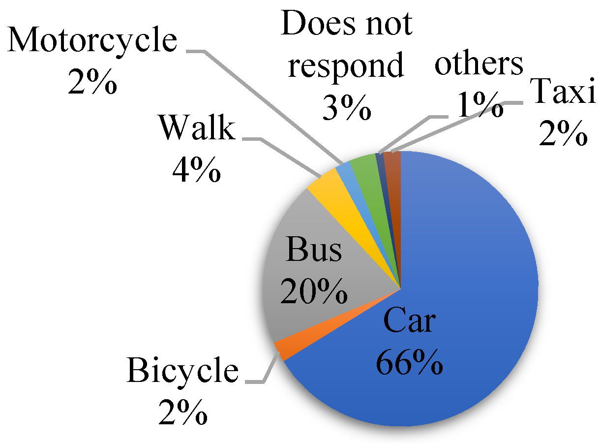
The survey incorporated questions tailored to shed light on the respondents’ vehicular usage patterns and their charging preferences should they own an EV. When asked, “What type of transport do you use daily?”, 66% of participants predominantly answered that they use their personal vehicles, whereas 20% use public transportation. This data accentuates the prevailing reliance on personal vehicles as the chief mode of transportation in Cuenca. A graphical representation of the most commonly used transport methods is depicted in
Figure 1.
In answer to, “What is the average distance you travel in a day?”, the findings indicated 10% of the respondents cover less than 3 km daily, 43% traverse distances between 3 km and 10 km, 42% journey beyond 10 km, and 5% abstained from answering. A distinct question regarding the weekly frequency of car usage, depicted in
Figure 2, highlighted that 69% of those surveyed operate their vehicles every day. On being inquired, “Would you consider purchasing an electric vehicle?”, a significant 75% responded positively, while 21% showcased a disinclination towards the idea, and the remaining 4% abstained from answering.
Finally, in response to the question “What would be the preferred place to charge EVs?”, 71.38% of the surveyed population indicated a preference for charging EVs at their homes, while the remainder favored charging at their workplaces. These findings are summarized in
Figure 3.
In Ecuador, the integration of EVs remains nascent. As of August 2022, the count stood at 1170 registered EVs out of a cumulative 2,361,175 motorized vehicles in the nation, making up roughly 4.95% of the entire vehicle fleet [
7]. It is important to emphasize that this data is sourced from independent magazines since official metrics on EV assimilation are not readily available. However, these figures resonate with the forecasts delineated in the national electromobility strategy.
Table 1 provides insights into the autonomy of the best-selling EVs in the Ecuadorian market. An average range of 308.66 km is shown. It is worth mentioning that this range is typically what the manufacturers specify. However, there is limited information available regarding how these vehicles perform in mountainous regions or areas characterized by significant variations in altitude. Small, low-range EVs without smart charging are a popular choice for urban transportation. However, they were not considered in this study because they are not designed for highway use. Highway driving requires a longer range and faster charging capabilities than these vehicles typically offer. The best-selling models in the United States are also shown, according to [
8], to compare the average range, indicating that, in the case of Ecuador, the average autonomy of the best-selling electric vehicles is considerably lower. This suggests that charging stations need to be located at shorter distances.
As shown in
Table 1, the average range of 308.66 km would theoretically allow EVs to reach nearby cities without difficulty. However, this is not the case due to the large altitude variation on Andean roads.
3. Road Transportation Allocation from Cuenca to Nearby Cities and Charging Corridors
The allocation of charging stations within charging corridors has recently become a focal point of research in various studies [
9]. The existing literature has identified two primary methodologies for selecting the locations of these stations: first, a node-based and, second, a flow-based approach [
10]. The model based on nodes is based on the placement of N charging stations to minimize the distances between nodes, a strategy applicable to all types of EV energy storage technologies [
10]. However, when dealing with alternative energy vehicles, which are constrained by limited travel ranges due to their batteries, these vehicles require multiple recharging stations along their routes [
11]. In these scenarios, the flow model is employed. This model is based on capturing the nearby charging demands of users traveling on a specific road while also considering the vehicle’s range. Nevertheless, this model is primarily suitable for short-distance trips.
Studies addressing the positioning of stations for long journeys within corridors often base their selection of interest points on cost consideration [
12] or on dividing the journey into N segments corresponding to the average range of the vehicles [
13]. The charging of vehicles during extended journeys through mountainous terrain characterized by significant variations in elevation has received limited attention, with only general location models for charging stations available. In the context of countries such as Ecuador, which are crossed by the Andes Mountains, specific studies in this regard are scarce.
The case of Cuenca is a valuable case study for the analysis of the location of charging infrastructure in Andean corridors. The city is located at a high altitude of 2500 m above sea level, which presents unique challenges for EV charging.
Table 2 shows the cities most visited by citizens of Cuenca, Ecuador. These cities are included in the city’s mobility plan, which identifies the most important transportation corridors and nodes in the region [
14].
The altitude variation in the Andes is a unique characteristic of the region. As shown in
Table 2, it is possible to travel from an altitude of 2500 m above sea level in Cuenca to an altitude near sea level in La Troncal in just 2 h and 38 min. This rapid change in altitude may have a significant impact on the performance of vehicles, including EVs.
Concerning the city of Cuenca, multiple highways link it to the cities of Guayaquil, La Troncal, Loja, Cañar, and Santa Isabel. These are the routes that cross the Andes Mountains to reach the equatorial coast. The journey spans elevations ranging from 2500 m to a maximum elevation of 4157 m (as shown in
Figure 4).
The route from Cuenca to La Troncal exhibits distinct topographical characteristics. Initially, the journey includes a section leading to the highest point, known as Tres Cruces de El Cajas. Beyond this point, the route descends, presenting an opportunity for EVs to regenerate their battery power through regenerative braking. However, the return leg of the journey features a segment characterized by minimal elevation, followed by an approximately 80 km uphill stretch. This uphill portion significantly diminishes the EV’s range. The routes to Macas, La Troncal, and Santa Isabel exhibit a comparable pattern: vehicles exert greater effort during the outbound journey from Cuenca compared to the return trip. This discrepancy arises from the fact that these destinations are situated at lower altitudes.
4. Charging Station Locations
The location of a charging station was based on several criteria, including distance traveled, existing electrical infrastructure, hotel infrastructure, among others. Priority was given to facilities situated near the existing electrical grids of the power distribution company. The determination of intermediate station locations considered several key aspects, such as:
Perception analysis of EVs: the perception and acceptance of electric vehicles (EVs) within the region were assessed in order to gauge the local market’s readiness for EV infrastructure.
Average range of existing EVs: the average driving range of currently available EVs was considered in order to ensure that the stations are optimally spaced to accommodate the vehicles’ capabilities.
Nearby tourist infrastructure: the presence of nearby tourist amenities and attractions was factored in, enhancing the appeal of the charging stations and providing additional incentives for travelers to utilize them.
Effect of elevation on EV range: the impact of variations in elevation on the range of EVs was considered in order to ensure that the stations are strategically located to mitigate range limitations, particularly in regions with significant elevation changes.
4.1. Nearby Tourist Infrastructure
A meticulous assessment of the hotel and tourism infrastructure, along the chosen routes, was driven by a clear objective: to provide electric vehicle users with compelling and enriching activities to partake in while their vehicles underwent the charging process. Recognizing the evolving landscape of sustainable transportation, this approach sought not only to promote electric vehicle adoption but also to enhance the overall travel experience for environmentally conscious tourists.
In the context of mountainous terrain, the analysis took into consideration the availability and quality of accommodation situated amidst breathtaking mountain landscapes. These lodgings were selected not only for their proximity to electric vehicle charging stations but also for their ability to offer travelers a comfortable and immersive experience within the captivating mountain environment. This approach aimed to encourage travelers to extend their stays, explore the surrounding trails, and embrace the spirit of adventure that mountainous regions offer.
Moreover, the assessment also extended to historical sites, recognizing their cultural and educational value for tourists. Electric vehicle charging stations strategically located near these historical landmarks provided an opportunity for visitors to delve into the rich history and heritage of the region while their vehicles charged. This alignment with cultural tourism not only enriched travelers’ experiences but also contributed to the preservation and appreciation of local history. Furthermore, the analysis considered routes known for their exceptional biodiversity. Charging stations positioned near areas conducive to wildlife observation and botanical exploration catered to eco-tourism enthusiasts. Travelers were thus encouraged to immerse themselves in the natural wonders of the region, engaging with local flora and fauna, and fostering a deeper connection to the environment.
These supplementary considerations encompassed ease of access, security for both EV users and maintenance labor, and, most critically, securing the willingness of the proprietors of these establishments to host an EV charging station. These parameters were pivotal in the decision-making process regarding the precise locations of these charging stations.
To systematically evaluate these aspects and assign them numerical values, the route was divided into segments. Utilizing information from Google Maps regarding tourist attractions, a grid with 5-km increments was created. This grid interval was chosen based on the density of tourist points of interest along the route. The values from
Table 3 were then applied to this grid, reflecting the weight assigned to each criterion and its placement within the grid.
In
Figure 5, the Cuenca–La Troncal route is shown, considering these parameters. The colors on the map represent the values assigned to each segment of the route, facilitating the identification of potential candidate locations for hosting charging stations.
4.2. Effect of Elevation Variation on EV Range
Considering the aforementioned parameters, a simulation was conducted to assess the impact of elevation variations along the Cuenca–La Troncal route on the autonomy of EVs. This simulation played a pivotal role in determining the optimal locations for the intermediate charging stations.
The simulation was executed using MATLAB (R2023b) and incorporated the fundamental model components of an EV, as depicted in
Figure 6a. This model encompassed elements such as a battery controller section, a driving cycle selector, and environmental conditions considering the route elevation [
15]. To simulate the effect of elevation changes, the road’s elevation profile was integrated into the model. Additionally, a World Harmonized Light Vehicle Test Procedure (WLTP) Class 2 driving cycle (as illustrated in
Figure 6b) was employed, as it aligns with the maximum speed limit (90 km/h).
5. Results
The simulations were conducted using MATLAB, considering both the outbound and return scenarios for each city. In all instances, an initial state of charge (SOC) of 80% of the electric vehicle’s battery was considered at the beginning of the journey.
Figure 7a illustrates the state of charge (SOC) behavior concerning the altitude along the Cuenca–La Troncal route against the simulation time, while
Figure 7b depicts the La Troncal–Cuenca journey. In the first case, it is apparent that the electric vehicle reaches its destination without requiring a recharge, attaining a minimum SOC level of 60%. However, on the return journey, the SOC drops to minimum values of 3.8%, a level that could potentially harm the battery. While it is true that the vehicle could reach its destination with an SOC of 8.8%, it is important to recognize that this outcome is contingent on various factors, including specific driving cycles and external variables, such as weather conditions, traffic, and more. Due to this inherent variability, the necessity for an intermediate charging station becomes evident, and its selection should be guided by the parameters detailed in the preceding sections. Hence, the installation of an intermediate charging station becomes necessary.
To ensure a safety margin for SOC levels between 15% and 30%, the selected charging station locations should fall within an altitude range of 2800 to 3300 m above sea level. This strategic placement of charging infrastructure not only guarantees a smooth and worry-free outbound journey but also mitigates the risk of battery damage during the return trip. It exemplifies the importance of data-driven decision making in optimizing electric vehicle travel experiences and sustaining the longevity of the electric vehicle battery.
Among the prospective locations for charging stations along the highway, those situated at elevations where the SOC falls between 15% and 30% were analyzed. We utilized the map depicted in
Figure 4 to identify locations that offer a combination of safety features, nearby activities, and dining options. Notably, the El Mestizo restaurant emerges as a prime candidate, positioned at an elevation of 3383 m. This restaurant is approximately 68 km from Cuenca and 84 km from La Troncal, offering an ideal SOC of 34%. The selection of this location was also driven by its suitability for constructing the necessary infrastructure for connecting the charging station, its provision of rest and touristic facilities for users, and its proximity to the electrical grid, as depicted in
Figure 8. A 50-kW direct current (DC) fast charge station was chosen to be installed at this location. The choice of this direct current charging station type offers several advantages, including reduced charging times, installation costs, and electrical network impact.
Considering an alternate route, such as Cuenca–Macas, it was observed that, during the outbound journey, the SOC reached a minimum of 2.4%. Similarly, while adhering to the safety margin for SOC between 15% and 30%, the viable options for charging station locations are constrained within the altitude range of 2500 to 2700 m above sea level. This altitude restriction ensures that electric vehicle users have accessible charging infrastructure for a secure and convenient travel experience along this route. On the other hand, when considering the return journey from Macas to Cuenca, it was observed that the minimum SOC reached was 8.2%. Consequently, a charging station is necessary within the altitude range of 780 to 910 m above sea level to ensure a reliable and efficient return trip for electric vehicle users (see
Figure 9).
Conducting a point-of-interest analysis, it was determined that, at an altitude of 2300 m, the city of Gualaceo should serve as the first charging point. Additionally, at an altitude of 800 m, the central restaurants of the Pupunas area were identified, located just 30 min away from waterfalls and various tourist attractions in the Amazon region (see
Figure 10).
Table 4 presents the results of the analyzed journeys, highlighting that all cases necessitate intermediate charging stations. Notably, it is observed that the sole route not requiring a return charging station is the Cuenca–Cañar route, owing to Cañar’s higher altitude relative to Cuenca. This distinction underscores the influence of altitude differentials on the charging infrastructure requirements for electric vehicle travel.
If we were to consider the average range of EVs in the country, it would indeed eliminate the need for charging stations along any of the analyzed routes. However, when applying optimization criteria, as demonstrated in [
16] where the authors found that the optimal distance between charging stations is every 100 km (as shown in the
Table 5), it would necessitate four intermediate stations. Nevertheless, considering the elevation factor, the requirement increases to seven charging stations. This elevation-related adjustment significantly impacts the investment needed to acquire and deploy these stations, highlighting the importance of accounting for topographical factors in charging infrastructure planning.
Lastly,
Table 6 displays the characteristics derived from the analyzed journeys. Parameters such as SOC per second or SOC per altitude are evident. These parameters enable the characterization of the roadways, allowing users to gauge the percentage of SOC they will lose for every second of travel. This information empowers travelers to plan their journeys more effectively, taking into consideration the impact on their electric vehicle’s SOC.
6. Discussion
Results obtained demonstrate that in high altitude corridors, the autonomy of EVs varies considerably. It is also notable that routes from low to high altitudes require a greater number of charging stations because, in this scenario, regenerative braking does not present a considerable advantage. Likewise, in the journey from high to low altitudes, and due to a high rate of descent per minute, the regenerative brake means, in several cases, that charging stations are not required, obtaining recoveries of up to 40% of the SOC. It was also observed that routes with maximum slopes greater than 50% and with distances greater than 200 km require two charging stations, while routes with lower slopes and lower routes require one station.
The existing literature typically considers parameters related to vehicular traffic and electric vehicles for the placement of charging stations. Thus, studies like [
10] use mathematical optimization based on traffic flow to locate stations along a corridor. Another study conducted on highways [
17] utilizes peak traffic parameters, vehicle energy consumption, and station characteristics. A direct analysis of altitude variation as a determining factor was not found, which means that this paper addresses a parameter that is usually not considered in the placement of stations on highways.
The use of the standard MATLAB electric vehicle model allows the analysis of sedan-type vehicles on first-order highway routes. Additional analyses should be performed for heavy transport vehicles and on second-order roads in order to better characterize high-altitude roads and their impact on SOC by considering additional parameters, such as road quality and vehicle type.
It was observed that there is no major variation in the number of charging stations depending on the driving profile. This is because the incidence of the road slope is greater than the effect of the type of driving because the geography of this type of road limits the maximum speeds at which the user can drive safely.
It was also observed that the SOC analysis is a priority and is complemented by the analysis of nearby tourist infrastructure; however, it should be highlighted that this infrastructure is consistent with the interest points identified based on the SOC. This is mainly due to the fact that the hotel infrastructure is located on plains, after stretches of significant slopes, and that it mostly has restaurants that are used by heavy transport drivers. This correlation is important because it would indicate that in high-altitude cities, charging stations can be located in resting places for the transportation of goods.
On highways like those in Ecuador and in various countries around the world, tourism infrastructure plays a decisive role in the placement of charging stations. Advanced technical studies are of little use if there is no place for users to safely charge their vehicles and have activities or places to visit while charging. It should also be considered that the location of charging stations is a boost for tourism in developing countries or those just beginning to integrate electric vehicles into their networks, as users will have the opportunity to explore these stations and use the tourism infrastructure.
7. Conclusions
This case study introduces a methodology employed for the strategic selection of electric vehicle charging station locations along mountainous roadways, such as the Andes Mountain range. The approach considers both driving patterns, state of charge, and the elevation above sea level of the roadway. It is worth noting that vehicles with shorter-range capabilities necessitate a complete recharge cycle, a process that can span anywhere from 1 to 2 h using DC fast chargers or extend to up to 6 h when opting for a slower charging approach, which is consistent with prevailing charging profiles for such vehicles. To cater to the needs of users during these recharging intervals, the vicinity of the selected locations offers limited recreational activities, primarily centered around the observation of local flora and opportunities for leisurely walks, restaurants, and others. Nonetheless, the relatively limited availability of these activities presents an opportunity for public entities to enhance the quality and quantity of leisure options in the vicinity of these charging corridors, thereby stimulating tourism and facilitating a more engaging experience for EV users.
Assessing the perceptions of local citizens concerning electromobility reveals notable trends. Approximately 66% of respondents in the survey rely on personal vehicles, primarily for daily routes spanning distances ranging from 3 km to 10 km. Notably, the survey underscores that merely 19% of respondents express a willingness to consider purchasing an EV. The majority of those disinclined towards EV adoption cite factors associated with limited familiarity with the technology and, notably, concerns surrounding maintenance and customer service.
At altitudes ranging from 2250 to 4100 m above sea level, market-derived data indicates an average EV autonomy of 308.66 km, given the absence of official electromobility statistics in Ecuador. These findings serve as valuable insights into the local EV usage patterns and energy consumption trends, providing a foundational basis for informed decision making in the realm of electromobility infrastructure development.
This work provides insight into the effect of altitude variation on electric vehicle autonomy from a perspective based on regenerative braking. However, it is necessary to conduct an in-depth analysis of different driving profiles. Additionally, it is necessary to obtain profiles that are specific to mountain road routes since the slopes may infer that the driver will change their driving strategy and, therefore, the vehicle’s autonomy will also vary. It is also necessary to conduct a techno-economic analysis and modeling based on the proximity of the stations to various points of interest.
The electric vehicle charging infrastructure in Ecuador is very new. The present study shows the development of the first charging corridor in the country, which means that information on the use of these stations is still needed. The electric vehicle market is still small, and there is no official information on the use of these vehicles on highways, making it necessary to analyze this behavior.


 ,
, 


