Article

Social Impact Scoping Using Statistical Methods: The Case of a Novel Design of Abandoned Farmland Policy

1
Faculty of Collaborative Regional Innovation, Ehime University, Ehime 7908577, Japan
2
Faculty of Business Administration, Kindai University, Osaka 5778502, Japan
*
Author to whom correspondence should be addressed.
Sustainability 2023, 15(4), 2929; https://doi.org/10.3390/su15042929
Submission received: 6 January 2023 / Revised: 26 January 2023 / Accepted: 31 January 2023 / Published: 6 February 2023
(This article belongs to the Section Air, Climate Change and Sustainability)

Abstract

:
This study discusses the methodology for social impact scoping (SIS) by employing a case study of novel policy design for resolving the issue of abandoned farmland in Ehime Prefecture, Japan. When conducted by using state-of-the-art methods, SIS can contribute meaningful information for policymaking even in conditions of limited resources. In this study, a choice experiment (CE) was conducted to analyse the desirability of alternative policies for abandoned farmland among local people; additionally, the Bayesian efficient design was employed; this design generally reduces sample size to obtain the statistical significance of the survey results. The increase in abandoned farmland worldwide has been linked to regional, national, and global environmental concerns, such as biodiversity loss and the reduction of landscape diversity; it has also been proven to be a serious problem regarding local sustainability. This study showed that the SIS results can be used to determine measures to prevent farmland abandonment. Overall, the respondents stated that this survey was meaningful for examining measures for abandoned farmland, which suggests the usefulness of implementing SIS by using this type of survey. Thus, this study showed that SIS is a methodology that can pre-screen policies to enhance social well-being even in conditions of limited resources for evaluation and when certain assumptions can be made regarding the choice-based analysis.

1. Introduction

There exists a substantial acreage of abandoned or underutilised farmland worldwide [1], causing either positive or negative environmental and social impacts on a large scale [2,3]. Farmlands in Japan have degraded and been abandoned due to factors such as being located in mountainous regions, farmland owners’ ageing or reduced physical abilities due to illnesses, agricultural worker shortages, and crop damage caused by birds and animals [4]. While the increase in abandoned farmland worldwide has been linked to environmental concerns at the regional, country, and global levels, such as biodiversity loss and reduction of landscape diversity [5,6], it also poses considerable problems for local sustainability in Japan. Some of these issues include the stagnation and economic decline of the agricultural industry, reduced local food self-sufficiency, crop damage caused by birds and animals, landscape degradation, etc. Additionally, associated problems such as the illegal dumping of garbage are expected to be exacerbated in the future. Although various measures have been implemented to deal with abandoned farmland in the past, as the situation surrounding agriculture and rural areas is rapidly changing, it is necessary to consider new measures not bound by existing methods. To do so, it is necessary to solicit and analyse a wide range of opinions from the public and predict whether the proposed measures will have a positive or negative social impact on stakeholders. As many agricultural and rural projects struggle with funding, it is also necessary to consider cost-effective policies.
In this study, the authors applied the social impact scoping (SIS) method in Ehime Prefecture, specifically, to Iyo City in Japan, to examine effective measures for abandoned farmland. SIS analyses the impact of policies by understanding the issues and predicting the most likely impacts [7]. It combines statistical research with relatively simple qualitative surveys to preliminarily evaluate policies and policy projects. Irie et al. [7] implemented sector-wide SIS, for which statistical analysis such as a t-test was conducted in addition to interviews. They identified the advantages and issues of installation of solar power generation over farmland, obtaining useful results to improve project content. However, since the statistical survey in their study directly asked citizens about the predictive degree of social impact, their results may have been affected due to the general public’s lack of familiarity with answering questions of such a nature. Additionally, although the impact was expected to differ in each region, the analysis was conducted nationwide to ensure sample size.
Consequently, in the present study, advanced statistical methods are applied to improve the methodology of SIS and analyse preventive measures for abandoned farmland. We applied a choice experiment (CE), in which policies were presented as options, and desirable policy choices were made by the respondents; making responses of such nature is not difficult for general adults. Additionally, we employed an efficient design to improve the efficiency of the choice experiment; further, we employed a sequential experimental design, which divides the experiment into two or more stages, utilising prior information obtained by the experiments in the initial stage to design experiments in the later stage. These sample-reducing methods should be applied when only smaller samples are obtained from a few municipal regions. SIS conducted by using these methods is consistent with the social impact assessment (SIA)—that is, the traditional approach of assessing concrete policy alternatives and their specific impacts in local areas.
The remainder of this paper is organised as follows. Section 2 explains the SIS methodology. Section 3 illustrates a case study of the abandoned farmland policy design in Ehime Prefecture. Finally, Section 4 presents the conclusions and discusses methodological issues concerning SIS.

2. Methodology

2.1. Social Impact Scoping (SIS)

The methodology of SIS corresponds to the first phase of the SIA. International standard SIAs comprise four phases: understanding the issues, predicting the likely impacts of policies, developing and implementing strategies, and designing and implementing monitoring programmes. SIS incorporates the first two phases of SIAs [8]. Social impact is defined as the effect on the people involved due to change—that is, ‘the real and perceived impacts experienced by humans (at individual and higher aggregation levels)’ caused by the biophysical and/or social change processes generated by planned interventions [9] (pp. 24–25), [10]. SIS is a method of evaluating the economic and social environmental impacts of policies and identifying issues and measures for improvement [7]. Typical research questions in SIS (Table 1) include finding policy options or alternatives, their relevant stakeholders, positive and negative impacts of the alternative policies, characteristics/factors of impacts, social acceptance of the policies, enhancement of positive impacts, and mitigation of negative impacts.
SIS is effective for proactive policy pre-screening when policy interventions are implemented for a large number of units and the content of potential impacts on each unit is expected to be relatively similar; even if the unit is small in size, effects having similar directions may be accumulated; thus cumulative social impacts are potentially large. For example, Irie et al. [7] analysed the social impacts of many agrivoltaic power stations installed over farmland on agricultural stakeholders and citizens. SIS can also be implemented efficiently when state-of-the-art methodologies are applied. While agricultural or environmental measures are often associated with budgetary constraints, SIS can be implemented with relatively few resources; it can be implemented via several interviews and statistical surveys, including online surveys.

2.2. Procedure of SIS

SIS analyses the impact of policies by understanding the issues and predicting the most likely impacts of policies [7]. To understand the issues of abandoned farmland in this study, literature research, pre-interviews, and information exchange with experts and potential stakeholders via email were conducted. Subsequently, issues and the purpose of the SIS (including the object of the SIS) were examined; types of social impacts were identified; and alternative options and relevant stakeholders were analysed. To predict the likely impacts of potential policies, the following research methods and surveys were implemented.

2.2.1. Pre-Research

For predicting the social impacts of potential policies, a broad range of social impacts was extracted via in-depth interviews and supplementary interviews, and by referencing previous research [11]. Subsequently, the economic, social, and environmental impacts predicted by policy stakeholders were analysed via pre-research.

2.2.2. Prediction of Impacts by Surveys

The positive or negative impacts of potential policies were analysed for each stakeholder group. The levels of predicted impacts were concretely specified, such as near future individual, community, future generational community, or global levels. Statistical surveys are more effective when efficient state-of-the-art survey methods are used. For example, the stated preference method is often utilised in the evaluation of environmental policies, such as a choice experiment (CE). There are various models of CEs, but the ‘workforce’ of CE, which has often been utilised in practice, is the multinomial logit (MNL) model [12]. CEs are used to determine the relative sizes of the utilities of two or more characteristics, or attributes, of a good (such as a product) or service [13]. In CEs, it may be effective to use state-of-the-art experimental design methods, such as the efficient design method, which makes it easier to obtain significant statistical results, even if the sample size is small. When employing the efficient design method, some prior information about the functional forms and coefficient values of the utility functions is utilised in the middle of the experimental phase. This is often conducted from the standpoint of D-efficiency, where the standard errors of predicted utility functions calculated from the asymptotic variance-covariance matrix, the negative inverse of the expected Fisher information matrix [12], are minimised. It is a different experimental design concept from the more traditionally utilised orthogonal designs [14,15,16]. Caution should be exercised as the efficient design should be used only when it is sufficiently verified that priors are not far from true parameter variables [17]. Sequential design, in which the results of the experiments of the initial steps are utilised in experiments in the later steps, is a method of applying the efficient design [18,19]. If the Bayesian efficient design method is used in the experimental design, it is possible to perform experimental designs that are expected to be efficient, while also reflecting the uncertainty of the prior distribution. Consequently, this study employed the Bayesian efficient design.

3. Measures against Abandoned Farmland
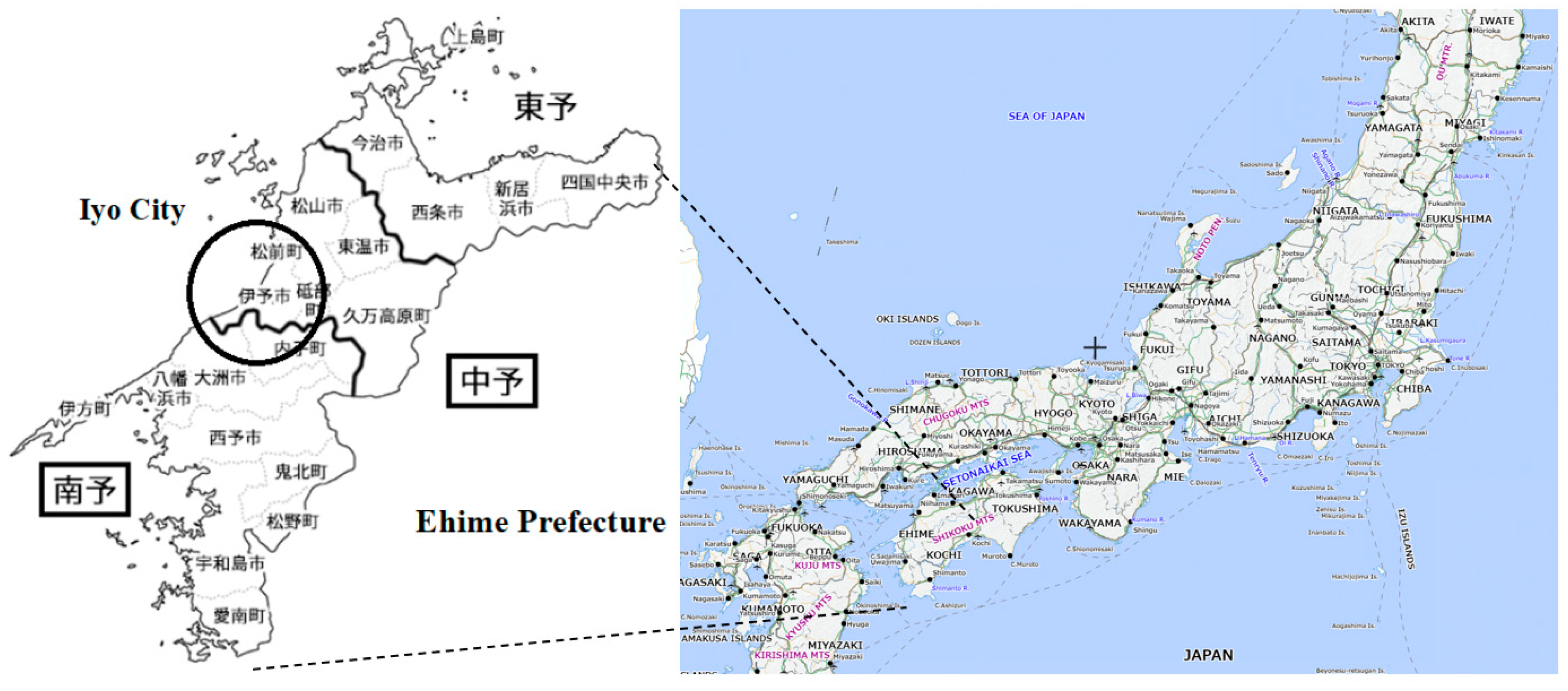
3.1. Case

In this study, SIS was conducted in Ehime Prefecture, Japan. Ehime Prefecture (Figure 1) is one of the islands (Shikoku) located in western Japan. Iyo City is located almost in the centre of Ehime Prefecture, facing the Seto Inland Sea to the northwest, and is approximately 10 km from Matsuyama City, the prefectural city of Ehime. It is characterised by a warm climate, the terrain is rich in variety (from flat paddy fields to mountainous areas), and the forms of farming and products are diverse. Paddy vegetables such as rice, wheat, lettuce, and edamame are cultivated in flat paddy field agricultural areas; citrus fruits are cultivated in fruit orchards; and, chestnuts and summer and autumn vegetables are cultivated in mountainous agricultural areas [20]. Examining measures regarding farmland abandonment in Ehime prefecture and Iyo City enabled the effective utilisation of SIS as follows. First, although the magnitude of the impact differs depending on the location of the farmland, the impact perceived by local people of the measures against abandoned farmland can be summarised into several types, as described later, suggesting that the impact content is fairly homogeneous. Second, measures dealing with abandoned farmland have a small impact on one unit, but if they are applied to a large number of farmlands, considerable cumulative impacts will occur. Third, while it is difficult to ensure large amounts of public funding to address countermeasures for abandoned farmland, this issue impacts local sustainability significantly.

3.2. Understanding the Issues

3.2.1. Issues, Objectives, and Evaluation Objects

We studied the literature produced in the Japanese context and a field survey in Ehime Prefecture (Matsuyama City, Ozu City, Uchiko Town, and Saijo City). This field survey was conducted from 2017 to 2019 with support from the Japanese Government for farmers and citizens in Hiroshima Prefecture (located in the areas surrounding the Seto Inland Sea) on the problem of abandoned farmland. Japan Grant-in-Aid for Scientific Research of the Ministry of Education, Culture, Sports, Science, and Technology provided funding for this study. Several field surveys have also been conducted by students at Ehime University. These investigations revealed that while the problem of abandoned farmland is strongly recognised by those involved in agriculture, many ordinary citizens, including people living in urban areas, also regard it as a serious problem, especially because of the recent serious damage caused by birds and animals and the notion that land not used effectively will be wasteful. Therefore, many local people consider that more effective measures should be implemented regarding abandoned farmland.
Subsequently, we examined the purpose of this study through in-depth interviews and information collected via e-mail with the Iyo City government (Appendix A). All interviews were recorded with the interviewees’ permission, transcripts were made, and the transcripts were double-checked by another interviewer who did not conduct the interviews. The Iyo City government officials recognised that abandoned farmland is a serious problem and that it is caused due to fundamental problems such as the ageing of the population, labour shortages, an increase in the number of non-farmers with farmland, sluggish crop prices, and the lack of profitable crops, in line with the nationwide trend in Japan. Additionally, the Iyo City government officials recognised that while various measures against abandoned farmland have been applied, regenerating land is very expensive once it was abandoned and that there was little incentive to regenerate farmland if it was not profitable to produce crops. Therefore, the prevention of abandoned farmland—rather than its regeneration—should be prioritised and various measures, including previously unconsidered ideas, should be examined to prevent a rapid increase in abandoned farmland.
Therefore, the purpose of SIS was set as ‘devising effective measures to prevent further increase in abandoned farmland’. Additionally, the evaluation objects were the people living in Iyo City and Ehime Prefectures; in other words, the relevant stakeholders of the potential policy were Iyo citizens and citizens of Ehime Prefecture.

3.2.2. Types of Social Impacts, Alternatives, and Stakeholders

Social impacts of abandoned farmland were recognised by Iyo City government officials, including the conservation and effective use of farmland, crop damage caused by birds and animals, impact on local agriculture, industrial promotion, economic revitalisation, impact on the multiple functions of water source forests and farmland, impact on local food self-sufficiency, and impact on policy costs.
Alternative measures and their feasibility in terms of compatibility with existing regulations, technology, and the economy (budgetary) were considered. The stakeholders facing the impacts of the potential measures were identified; stakeholders in addition to the Iyo City government were identified, including agricultural operators living in Iyo, people other than agricultural managers working in agricultural sectors such as those working for agriculture-related organisations and companies in Iyo, and Iyo citizens (living far from farmland and living near farmland). Sectors where social impacts would be incurred (people, companies, and organisations) and important sectors that needed to be analysed were identified.

3.3. Predicting Likely Impacts

3.3.1. Pre-Research

In-depth interviews were conducted with supplementary information collected via e-mail from important stakeholders (members of agricultural cooperatives in Iyo City, farmers in Iyo City and Ehime Prefecture, Iyo citizens, and Iyo City government officials) (Appendix B). Interviews were recorded and transcripts were double-checked. In the interviews, the impact of abandoned farmland (Table 2) and the promising measures that can be implemented in the next 5 to 10 years that were expected to have a positive social impact (Table 3) were extracted. Table 3 lists the measures by excluding ones considered to be less feasible.
Subsequently, a preliminary statistical survey with a sample size of 205 (pre-test) was conducted in Ehime Prefecture in December 2019 to analyse the social impacts perceived by citizens at the regional level, predicted to occur 10 years from now, and the factors for their preferences (Appendix C). In the questionnaire, the opinions of other stakeholders regarding the predicted social impact of abandoned farmland were shown to aid respondents in making better social choices. Regarding the number of years of residence, 36% of Iyo City residents had lived there for more than 50 years, while the figure of people residing in the same city for more than 50 years was 5% of the total number of respondents in other cities, which was significantly different; however, there was no other significant difference between the samples in Iyo City and other cities in terms of social demographic variables (SDVs). Regarding the five most popular measures (Measures 1 to 5 in Table 4) that were expected to have a positive impact on the region, there were no significant differences in the degree of positive social impacts evaluated by people living in Iyo City and other cities in Ehime Prefecture.
When opinions were asked about the incurrence of payment by residents if measures desired by them were chosen to be implemented in their areas, 27% of all respondents were in favour of paying the contributions, 40% opposed them, and 33% were neutral. The average amount that residents were willing to pay (WTP) per year was 1610 JPY per person when the measures they deemed best were implemented, and there was no statistically significant difference between respondents of Iyo City and other cities in Ehime Prefecture regarding this amount. However, there was a wide range of WTP amounts, with some people exceeding 10,000 JPY and nearly 40% of the respondents paying 0 JPY; subsequently, it became clear that there was a problem in considering the average amount. There was no relationship between a high score on the social impact of the measures and WTP. For people who had successors and older people, the WTP increased. Supplementary interviews were also conducted with Iyo citizens, which were used as a reference for the survey design in the next step.

3.3.2. Prediction of Impact by Sequential Statistical Surveys by Applying the Bayesian Efficient Design Method

For the five popular measures mentioned above, large-scale statistical surveys were conducted to assess the social impact predicted to occur 10 years hence on the area as recognised by citizens.

Design of the CE

A self-completion questionnaire was designed; this questionnaire was designed in a way that was easily comprehensible by elderly residents. The efficient design method was applied by using Ngene version 1.3 [23]. To use the results of the initial stage experiments as preliminary information for later experiments, a sequential design that divided the experiment into four stages was implemented. Survey A was designed by using information from the pre-test. Subsequently, Survey B was designed by using prior information from Survey A. The experimental design of Survey C did not utilise prior information to assess the efficacy of the efficient design method. The CE parts of Surveys A, B, C, D, and E (Appendix D.1) were identical for making use of the combined results later.
The questionnaire asked each respondent to choose their preferred type of abandoned farmland measure out of six alternatives, including the five prioritised abandoned farmland measures and the status quo, which was no measure. The status-quo option was included to prevent forcing respondents to implement one of the mentioned abandoned farmland measures [24], although this treatment may have increased status-quo bias [15,25,26]. The attribute and its levels are presented in Appendix D.2. The cost of measures, defined as the yearly hypothetical cost per local person to implement the measure, was set as an attribute.
The results of the pre-test suggest that information from cities other than Iyo City could be used as prior information for the preferences of Iyo people to analyse the social impact of the top five measures. The Bayesian efficient design of Surveys D and E used posterior means and standard deviations of the combined samples of Surveys A, B, and C as prior information. Since the standard deviation was not rejected for all variables when estimating the mixed logit model by using the combined sample, Surveys D and E were designed by assuming an MNL model, in which only the content of the measure (alternative specific constant: ASC) and the cost of burden of the measure were the included variables. MNL was also regarded as valid in this case, as randomised alternative specific constant (ASC) would lead to an unidentifiable problem [12] (p. 308). Although the model employed in this study is much simpler than typical CEs, it was expected that such a simple model would obtain the same t-value even if the sample was approximately 10% smaller. In this study, the improvement of estimation was not that obvious because of adopting this highly simplified model including only ASC and cost -explanatory variables in the experimental phase. The improvement of the estimation in typical CEs having more than three attributes may be more obvious [23]. The questionnaire also included questions on the meaningfulness of this type of survey.

Data Collection

The questionnaire was used to conduct both paper-based and online-based surveys. The surveys were carried out by professional survey companies (Appendix C). After the surveys were implemented, all responses collected from Surveys A, B, C, D, and E regarding the CE part were unified, resulting in a total of 753 respondents with a sample size of 6024. After data cleaning by excluding the ‘NA’ and insincere answers, the sample size was 4096. Appendix E.1 and Appendix E.2 present the population and sample statistics, respectively. Appendix E.1 shows that in Japan, approximately 3% of the population are farmer household members, while in Ehime Prefecture and Iyo City, 4% and 11% of the population, respectively, are farmer household members. This indicates that for Ehime Prefecture and Iyo City, agriculture is an important industry compared to the whole of Japan. However, the older adult agricultural population in Ehime Prefecture is larger than the older adult agricultural population in the rest of Japan. Ehime Prefecture and Iyo City had slightly higher female percentages (53%) of the total population than those across Japan (51%). Appendix E.2 presents the characteristics of the survey participants. The sample characteristics of Iyo City were different from those of other cities, except for the portion of people working in the farm industry (‘ind’). The SDVs of the Ehime Prefecture sample were more similar to those of the Japanese population than those of the Iyo City sample. The Iyo City sample had on average higher percentages of females (0.46% vs. 0.42%, for Iyo City and other-city samples, respectively), elders (0.43% vs. 0.35%), lower college undergraduate/graduate (0.37% vs. 0.46%), lower individual income (0.22% vs. 0.24%), more farmer portion (0.30% vs. 0.13%), the same proportion of working for farm industry (0.04% vs. 0.04%), a higher proportion of non-farmer living near farmland (0.50% vs. 0.43%), higher relevance to farming (0.44% vs. 0.25%), higher indicators of no-agricultural successors (0.15% vs. 0.05%), living less in city agricultural area (0.08% vs. 0.17%), living more in a flat agricultural area (0.40% vs. 0.31%), medium elevation agricultural area (0.20% vs. 0.17%), and mountainous agricultural area (0.12% vs. 0.06%), farther from the city centre (0.49% vs. 0.38%), and longer residential period (0.36% vs. 0.32%). Compared to SDVs, values/opinions/lifestyles were more similar between Iyo City and other cities, which were also similar to those of Japan. As a later analysis shows, some of these differences could be caused by the survey media, namely, whether the sample was collected via the Internet or by paper. However, the above differences between Iyo City and other city samples and survey media were mitigated by controlling for these variables as explanatory variables in the estimated models in the later stage.

Model Specification

CEs are based on the random utility model, which maintains that the utility of goods and services is composed of deterministic or systematic and observable (V) and stochastic components [13]. The basic behavioural model for a CE is:
Unj = Vnj + εnj,
where n is the respondent, j is an option, and Unj (j = 1, , J) is the utility that respondent n obtains from option j [12]. Vnj is a systematic component of utility Unj, which is a function of option j’s attributes and respondent n’s characteristics; εnj is a random component that affects utility Unj. If Uni > Unj jI for respondent n, respondent n chooses i. The simplest choice experiment model is the multinomial logit (MNL) model. The systematic terms of utility values are:
Vnj = βxnj,
where β and x are vectors.

Estimation

The models were estimated by using the ’mlogit’ package in the free software program R version 4.1.2. First, alternative-specific (null) and cost-only models were estimated. Second, explanatory variables, one-variable, two-way, and three-way intersection terms, were added to the cost-only model to examine whether they led to an improvement in the values of the Akaike information criterion (AIC). Finally, alternative specific coefficients, costs, and explanatory variables with higher AIC impacts were included in the model, and the estimated and insignificant variables were excluded. The AIC of the alternative specific coefficients only (null model) was 14566, while the adopted model, which had the lowest AIC value, was 13550. The estimates of the adopted model are presented in Appendix F.

3.4. Answers to the SIS Research Questions on Abandoned Farmland Policy

Appendix G presents the average utility values for each stakeholder group. The costs were assumed to be 4.5 M JPY for all policies. Utilities were calculated by summing all utility values for the different stakeholder groups estimated in Appendix F. For example, the estimate of ‘A1,’ −1.483, which is the utility compared to the status quo when Measure 1 is implemented, is the utility perceived by every stakeholder, while the estimate of ‘A1sexresp,’ −1.837, which is the utility when Measure 1 is implemented, is the one only for females (sex = 1) and the respondents whose residential period (‘resp’) is higher. Summing all utility values relevant to each stakeholder group led to the average utility value of the stakeholder group. Appendix G.1 shows the utility calculated based on the population structure regarding sex, age, and farmer/non-farmer status. Because there were no data regarding the individual income of Ehime residents, higher/lower income was set twice for each. Appendix G.2 shows the utility calculated based on equal weights for each stakeholder preference. As the population structure is based on smaller percentages of farmers and the elderly, the assignment of equal weights to each stakeholder’s preferences led to a greater weighting of the preferences of farmers and the elderly. Based on these utility values, the answers to the research questions were considered as follows.

3.4.1. What Are the Policy Options and Their Relevant Stakeholders?

The policy options were extracted as five alternative measures: Measures 1 to 5, and the relevant stakeholders were residents of Iyo City and other cities in Ehime Prefecture.

3.4.2. To What Extent Are Alternative Policy Options Predicted to Have Positive or Negative Impacts for Different Stakeholders?

The social choice depends on the weights of the different stakeholders’ preferences. When utility is considered based on population structure, Measure 2 is the most preferred measure for both Iyo City and Ehime Prefecture. Measures 3 and 5 are the least preferred and have negative utility throughout Ehime Prefecture.
If equal weights are assigned to each stakeholder group, Measures 1 to 4 have positive predictive impacts on average, Measure 5 has a negative predictive impact for both Iyo City and other city people on average, and Measure 1 is expected to have the highest positive utility for both Iyo City and other cities. However, caution should be exercised since the paper survey led to the lower utility values for Measures 1 and 3 because ‘A3iipaper’ (−2.874) and ‘A1farmpaper’ (−1.586) had negative values. As the utilities in Appendix F are calculated by average utility values of relevant respondents and paper surveys were conducted for only 15% of respondents, Measures 1 and 3 may be less valued when the percentage of respondents of paper surveys was much higher. For example, if 60% of all respondents participated in paper surveys, the impacts on the utility could become 0.45 times (0.60–0.15) of the coefficients, leading to the maximum 1.29 decrease in utility for Measure 3 and 0.71 decrease in utility for Measure 1. This suggests that Measure 3 may produce negative unities both for Iyo City and other cities. Measure 1 may also have negative impacts if utilities are calculated based on the population structure. Namely, while the average positive impact is expected to be smaller for Measure 2 than for Measure 1 when equal weights on the stakeholder are assigned, the utility values of measures depend on the research media (i.e., whether the research is conducted on paper/online surveys). Measure 2 was perceived as the most desirable measure by Iyo City and other cities in Ehime Prefecture, regardless of the research media.

3.4.3. Would Implementing a Policy That Has Favourable Features Be Generally Acceptable to All the Stakeholder Groups?

Measure 2 is the most socially acceptable measure; however, male non-farmers show negative utility for this measure. Male non-farmers comprised 45% of the Ehime Prefecture population (Appendix E.1), meaning that 45% of the population in Ehime Prefecture found Measure 2 unacceptable. Considering that other measures are also unfavourable to non-farmers and that more than half of the population predicted positive impacts for Measure 2 suggests that Measure 2 could be regarded as the most legitimate to implement in Ehime Prefecture.

3.4.4. What Are the Factors Related to Different Sectors’ Predictive Positive and Negative Impacts? How Might a Positive Impact Be Enhanced and a Negative Impact Mitigated?

SDVs, including living places and periods, income, whether farmers or not, and sex, are significant factors for predicting the utility of alternative measures. The explanatory variables with higher positive impacts on utility are SDVs, while value/opinions/lifestyle do not have large effects on utility for alternative policies (Appendix F). However, all significant variables explaining positive/negative impacts are related to measures other than Measure 2. The variables having higher impacts include A1iiage (Estimate: 7.023) for Measure 1, A4farmdistance (4.342) and A4iimoag (3.929) for Measure 4, and A5sexVsig (7.983) for Measure 5. However, variables with higher negative impacts include A1iiresp (−4.398) and A1age (−3.491) for Measure 1, A4farmage (−4.957) and A4farmmoag (−3.848) for Measure 4, and A5sex (−8.543) for Measure 5. All the maximum and minimum values of one-term explanatory variables range from one to zero, meaning that the impacts of the explanatory variables roughly correspond to their estimated coefficient values. This result suggests that, for Measure 1, which is deemed as a traditional agricultural promotion measure and the most preferred measure, the elderly respondents expect negative impacts on average, but that the elderly with higher income anticipate positive impacts. However, higher-income people anticipate positive impacts less when they live longer under Measure 1. Measure 4, that is, the promotion of citizen farms, has higher utility when farmers are living far from the city centre or when higher-income people are living in mountain agricultural areas. However, when farmers are older or living in a mountainous agricultural area, the positive impacts are lessened. For Measure 5, that is, the promotion of production by companies, which is the most unfavourable measure among the four alternative policies, females, in general, showed negative utility; however, when females thought that this study is meaningful, they did not have much negative utility. Having no agricultural successor, one of the factors which were predicted to have positive preferences for policies, was not significant except for Measure 5 (positive) and Measure 4 (slightly positive). As Measure 2 would be the most socially acceptable measure, it requires further analysis regarding factors for predicting its positive and negative impacts. Measure 2 is predicted to enhance positive impacts and mitigate negative impacts when it targets females living near city centres, females who are more educated and living for a short period, and people living in medium and mountainous agricultural areas. Measure 1 is predicted to enhance positive impacts or mitigate negative impacts when it targets elderly females, females working in the farm industry, higher-income elderly, lower -income people living long in flat agriculture areas, and farmers living in city agricultural areas. Therefore, areas with a higher proportion of these stakeholder groups would enhance the positive impact/mitigate negative impacts.

3.5. Usefulness and Limitations of SIS Regarding the Design of a Novel Abandoned Farmland Policy

This study showed that SIS effectively extracted potential measures from a wide variety of measures to prevent abandoned farmland, and could analyse the most desired measure for citizens in Ehime Prefecture and Iyo City, the target population of the SIS. As SIS may be perceived as insufficient compared to the implementation of a more comprehensive SIA, the questionnaire also asked respondents whether examining abandoned farmland measures in this way has certain implications for implementation. The average evaluation in the pre-tests was 1.27 and that for the survey was 1.17 (with 1: meaningful, 2: neither, and 3: meaningless), suggesting that the respondents, on average, felt that this survey was meaningful in examining abandoned farmland policy measures. This suggests the general usefulness of conducting SISs in this manner.
The limitation of SIS is the simplicity of the content of the results; as the first screening from a variety of policy options, the SIS is the first step of policy design, which needs further analysis for more concrete policy design. Another limitation is that SIS can analyse factors but cannot provide reasons for predicting positive or negative impacts. Further research should consider causal inference [27] for a more rigorous prediction of social impacts.

4. Conclusions

This study discusses the methodology of SIS by presenting a case study of abandoned farmland policy design in Ehime Prefecture, Japan. This study showed SIS to be informative for novel policymaking with few resources. The study employed a choice experiment and a state-of-the-art choice experiment method, the Bayesian efficient design; this design generally reduces sample sizes to obtain the statistical significance of the survey results. Using different weights for stakeholder preferences led to different results regarding recommended abandoned farmland policies. Paper and online surveys obtained different results regarding respondents’ preferences for some measures. The measure that was expected to have a higher positive social impact in Ehime Prefecture was: ’Information on farmland is posted in the vacant house database and the cooperation of real estate companies is obtained to collect and manage farmland information’. This measure is predicted to enhance positive impacts and mitigate negative impacts when targeting certain stakeholder groups. The measure was, at the time of this SIS, still rather vague in content, as the aim was to primarily extract promising feasible abandoned farmland policies not abiding by the existing methods or policies and needing further concrete specifications. However, SIS was shown to extract potential measures from a wide variety of measures to prevent abandoned farmland and could analyse the most desired measure for citizens of Ehime Prefecture and Iyo City, the target population of the SIS.
Asking for public opinion before examining new policies is usually difficult, especially when there is insufficient funding or resources to evaluate them; consequently, SIS can address this problem by screening policies which may enhance social well-being, when people sufficiently know policies’ consequences regarding themselves and there is no behavioural bias in their choices.

Author Contributions

Conceptualization, N.I.; methodology, N.I.; software, N.I.; validation, N.I.; formal analysis, N.I.; investigation, N.I.; resources, N.I.; data curation, N.I.; writing—original draft preparation, N.I.; writing—review and editing, N.I. and N.K.; visualization, N.I. and N.K.; supervision, N.I; project administration, N.I.; funding acquisition, N.I. All authors have read and agreed to the published version of the manuscript.

Funding

This research was funded by JSPS KAKENHI, Grant Number 17K00582.

Institutional Review Board Statement

Not applicable.

Informed Consent Statement

Not applicable.

Data Availability Statement

Not applicable.

Acknowledgments

The authors thank the Iyo City Government as this work would not have been possible without its assistance.

Conflicts of Interest

The authors declare no conflict of interest.

Appendix A. Stakeholder Interviews and Mail Exchanges for ‘Understanding Issues’

Interviewees
(Number of People)
IssuesMonth/YearMinute/TimeMethod
Iyo City government (3)Purpose and procedure of the SISAugust/201990 minInterview (face-to-face)
issues Iyo City government officials recognise regarding abandoned farmland
Iyo City government (1)Examination of the purpose of the SISAugust/201930 minInterview (telephone)
Iyo City government (1)Examination of the purpose of the SISAugust/20194 timesEmail exchange
Detailed understanding of the current situation of abandoned farmland in Iyo City, measures taken so far and their effects, and possible measures in the future
Iyo City government (1)Examination of specific survey contents, reviewing the investigation scheduleOctober/201930 minInterview (telephone)
Iyo City government (1)Reviewing the investigation scheduleOctober/20191 timeEmail exchange
Iyo City government (1)Determination of the investigation scheduleNovember/201960 minInterview (face-to-face)
Examination of current status and issues
Determination of research objectives
Determination of evaluation axes
Iyo City’s recognition of the social impact of abandoned farmland
Consideration of feasible countermeasure options

Appendix B. Stakeholder Interviews and Mail Exchange for ‘Predicting Social Impacts’

Interviewees
(Number of People)
IssuesMonth/YearMinutes/TimesMethod
Agricultural cooperation in Iyo City
(1)
What to focus on when considering abandoned farmland? Are the following social impacts important? What are the most important impacts? Are there any other important social impacts?November/201960 minInterview
(face-to-face)
Farmer in Iyo City
(2)
November/201960 min,
60 min
Interview
(face-to-face)
Farmer in Ehime other than in Iyo City
(2)
What options are likely to be available in measures against abandoned farmland? For example, how about the following options? (illustrating measures by the city)November/2019,
December/2019
60 min,
60 min
Interview
(face-to-face)
Iyo residence
(3)
January/2020,
February/2020
60 min,
60 min,
60 min
Interview
(face-to-face)
Iyo City government
(1)
Confirmation of the current status of farmland use and laws and regulationsDecember/20191 timeEmail exchange
Iyo City government
(1)
Examination of the feasibility of new countermeasures proposed by stakeholdersDecember/201960 minInterview
(face-to-face)

Appendix C. Pre-Tests and Survey (Paper/Online)

DateMediaSample SizeRespondentsPrior InformationPrior
Sample Size
Pre-test2019.12.25–2020.1.1.Online205Iyo and other citiesNon0
Survey A2020.2.7–14Online162Other citiesPre-test205
Survey B2020.2.12–19Online170Other citiesSurvey A367
Survey C2020.2.14–21Online279Other citiesNon0
Survey D2020.3.–4.Paper112Iyo CitySurveys A–C816
Survey E2020.3.Online30Iyo City816
The respondents were 22 in Iyo City and 183 in other cities in the Pre-test.

Appendix D

Appendix D.1. CE Example of the Pre-Tests and the Survey

To prevent a further increase in abandoned farmland, if you take any of the following measures or maintain the status quo within 5 to 10 years, which measures do you think will have the best impact on your area 10 years from now? Please answer only one.
Measure 1Measure 2Measure 3Measure 4Measure 5Statue Quo
Farmer training and farmland mediationVacant house database and cooperation with real estate companiesPromoting online matchingPromoting allotment gardenPromoting agricultural production by companies(No countermeasure is conducted)
Cost of measure
(per person per year)
Cost of measure
(per person per year)
Cost of measure
(per person per year)
Cost of measure
(per person per year)
Cost of measure
(per person per year)
Cost of measure
(per person per year)
600 JPY300 JPY300 JPY600 JPY300 JPY0 JPY
Answer column (circle only one).

Appendix D.2. Choice Experiment Attributes and Levels of the Survey

AttributeLevel
Cost of measure (per person per year)0 JPY, 300 JPY, and 600 JPY

Appendix E

Appendix E.1. Summary Statistics

UnitFemale/Male Total
TotalFarmerOther
>65<65>65<65
Iyo CityThousand persons35.12.01.710.021.4
%100652861
Ehime PrefectureMillion persons1.330.030.030.410.86
%100223165
JapanMillion persons126.11.61.934.588.2
%100122770
UnitFemale
TotalFarmerOther
>65<65>65<65
Iyo CityThousand persons18.71.10.85.911.0
%53321731
Ehime PrefectureMillion persons0.700.020.010.240.43
%53111832
JapanMillion persons64.80.80.919.643.5
%51111634
UnitMale
TotalFarmerOther
>65<65>65<65
Iyo CityThousand persons16.41.00.84.110.5
%47321230
Ehime PrefectureMillion persons0.630.020.010.170.43
%47111332
JapanMillion persons61.30.81.014.944.7
%49111235
Farmer: Household members of an agricultural management body (individual ownership); Other: other than farmers. > 65 years: 65 years old or older, < 65 years: younger than 65 years [28,29].

Appendix E.2. Summary Statistics for the Sample and Population

VariableDefinitionTotalIyo CityOther Cities
MeanMeanMean
SDVs
sexSex: Female = 1, Male = 00.430.460.42
ageAge: 100 years old = 1, 20 years old =00.370.430.35
edEducation: College undergraduate or graduate = 1, Other = 00.440.370.46
iiIndividual income: 13 M JPY a year = 1, 0.5 M JPY a year = 00.240.220.24
farmFarmer: Yes = 1, No = 00.170.300.13
indWorking for farm industry: Yes = 1, No = 00.040.040.04
nfnNon-farmer living near farmland: Yes = 1, No = 00.450.500.43
farmingDegree of relevance to farming: Very much relevant (Farming in living place) = 1, Much relevant (Farming outside living place) = 0.75, A little relevant (Working for farming industry) = 0.5, Not much relevant (Non-farmer living near farmland) = 0.25, Not at all relevant (Non-farmer living far from farmland) = 00.290.440.25
nosAgricultural successor: Not having agricultural successors and not having agricultural workers = 1, Having agricultural successors = 00.070.150.05
cagLiving in city agricultural area: Yes = 1, No = 00.150.080.17
fagLiving in flat agricultural area: Yes = 1, No = 00.330.400.31
magLiving in medium agricultural area: Yes = 1, No = 00.170.200.17
moagLiving in mountain agricultural area: Yes = 1, No = 00.070.120.06
distanceCloseness from city centre: Distant = 1, Nearest = 00.400.490.38
respResidential period: 65 years = 1, 1 year (less than 2 years) = 00.330.360.32
Value/opinion/lifestyle
Vag‘In the vicinity of abandoned farmland in my area, abandoned farmland is causing agricultural disadvantages’.: Very much think so = 1, Do not think so at all = 00.630.600.63
Vland‘It is important to ensure not to deteriorate the landscape by uncontrollable growth of grass and trees or farmland conversion in your area’.: Very much think so = 1, Do not think so at all = 00.760.820.75
Vfsec1‘Japan’s food self-sufficiency rate is low’.: Very much think so = 1, Do not think so at all = 00.770.780.77
Vfsec2‘Increasing Japan’s food self-sufficiency rate is important’.: Very much think so = 1, Do not think so at all = 00.830.850.82
Vac‘I am actively involved in the local community, Currently I am an area representative, counsellor, or residents’ association officer, or I have such experiences in the past, I am actively involved in activities in the town, residents’ associations or community centre activities, etc’.: Very much think so = 1, Do not think so at all = 00.400.440.39
VWTP‘It is important to take measures against abandoned farmland in my area, even if money is spent’.: Very much think so = 1, Do not think so at all = 00.690.680.70
Vsig‘Do you think it meaningful for this type of survey to consider preventive measures for abandoned farmland?’: Significant = 1, Insignificant = 00.890.880.90
Paper or online survey
paperPaper survey: Yes = 1, No = 00.150.750.00
IyoResidence in Iyo: Yes = 1, No = 00.201.000.00

Appendix F. Model Estimates

EstimateStd. Errorz-ValuePr (>|z|)
A1−1.4830.286−5.1840.000**
A40.2570.0723.5860.000**
A2sexVWTP1.3800.3084.4780.000**
A2sexVfsec20.9350.3352.7930.005**
A2Vsig1.0340.1606.4490.000**
A2sexVfsec1−1.1730.267−4.4030.000**
A2Vland1.4000.2555.4880.000**
A2sexdistance−0.6980.205−3.4060.001**
A2Vfsec2−0.8480.227−3.7360.000**
A2sexed0.2990.1262.3710.018*
A1farmcag1.2570.3343.7690.000**
A5sex−8.5432.010−4.2510.000**
cost2Vland−0.8630.197−4.3790.000**
A1iiVWTP2.3610.8292.8490.004**
A4iimoag3.9290.6076.4710.000**
A4farmage−4.9570.727−6.8160.000**
A2age−1.3520.274−4.9360.000**
A2sexresp−0.8880.281−3.1580.002**
A5sexnos1.1220.3353.3480.001**
A1VWTP0.7350.3082.3870.017*
A4sexnos−1.8180.717−2.5350.011*
A3age−1.7450.318−5.4820.000**
A2mag0.6000.1195.0280.000**
A5nos0.5290.2232.3760.017*
A3iipaper−2.8740.909−3.1610.002**
A1Vsig2.2530.3057.3860.000**
A1iiage7.0231.3765.1040.000**
cost3Iyo−1.2990.478−2.7170.007**
cost3Vfsec2−1.6550.344−4.8170.000**
A5sexage−1.2630.461−2.7380.006**
A5sexVfsec11.5260.3883.9320.000**
A1iiVland−2.1250.779−2.7280.006**
A3sexresp−1.2410.367−3.3790.001**
A1Vland1.0410.3053.4110.001**
A5sexVsig7.9832.0003.9920.000**
A1resp1.9420.3705.2490.000**
A3sexVag−0.6520.269−2.4290.015*
A1sexVfsec11.0030.2843.5260.000**
cost4Iyo−0.5710.159−3.5950.000**
A4farmmoag−3.8480.536−7.1840.000**
A5farmcag−2.2981.028−2.2350.025*
cost3Vland1.1340.3083.6760.000**
A3Iyo0.9200.3712.4810.013*
A4farmVac−1.1420.385−2.9700.003**
A3resp0.5100.2332.1910.028*
A4sexmoag−0.7320.338−2.1630.031*
A1Vfsec2−1.2510.297−4.2090.000**
A1iiresp−4.3980.860−5.1160.000**
A4iinfn0.6900.2482.7790.005**
A5ed0.9910.09210.7200.000**
A5Vac−0.6100.135−4.5250.000**
A5sexed−1.2300.213−5.7850.000**
A1sexVsig−0.6280.293−2.1460.032*
cost3VWTP1.4050.3094.5420.000**
A1sexage2.3380.5983.9130.000**
A1farmpaper−1.5860.318−4.9930.000**
A1age−3.4910.562−6.2140.000**
A2moag0.6520.1843.5410.000**
A3Vfsec10.4470.1702.6280.009**
A3farmed1.0510.2065.1020.000**
A3sexVsig0.9770.1994.9200.000**
A5farmmag0.5950.2222.6840.007**
A1sexind0.6120.2862.1360.033*
A5sexii1.3700.5032.7220.006**
A1farmVsig−0.7590.366−2.0760.038*
cost3farming−0.8230.245−3.3570.001**
A1farmVfsec21.1350.4142.7440.006**
A4farmdistance4.3420.5677.6600.000**
A1iifag−1.6690.293−5.6990.000**
A2farmVfsec1−0.7850.196−4.0130.000**
A1sexresp−1.8370.434−4.2300.000**
A4sexcag0.7400.1923.8460.000**
A3iimag2.0890.3306.3240.000**
cost1nfn−0.5650.119−4.7640.000**
significance <0.01 **, <0.05 *
log-likelihood−6701.1 AIC13550

Appendix G. Average Values of Utility for Each Stakeholder Group

Appendix G.1. Based on the Population Structure of Female/Male, Elder/Younger, and Farmer/Non-Farmer

SDVs Utility
sexageindividual incomefarmer/
non-farmer
weight (percentage of population)Measure 1Measure 2Measure 3Measure 4Measure 5
Female: sex = 1,elder: age
> 0.6,
lower income:
ii < 0.2,
farmer: farm = 1,Increasing farmer training and farmland mediationUsing vacant house databases and obtaining cooperation of real estate companiesPromoting web matching of agricultural successors and land ownersPromoting citizen farmsPromoting agricultural production by companies
Male: sex = 0younger: age
< = 0.6
higher income:
ii > = 0.2
non-farmer: farm = 0
0.4260.5280.3330.340−0.911
Femaleelderlowerfarmer1.5%1.2970.9440.7540.2570.007
Femaleelderlowernon-farmer8.4%1.8621.3060.8490.144−1.899
Femaleelderhigherfarmer1.5%1.2970.9440.7540.2570.007
Femaleelderhighernon-farmer8.4%1.8621.3060.8490.144−1.899
Femaleyoungerlowerfarmer1.2%1.2970.9440.7540.2570.007
Femaleyoungerlowernon-farmer15.6%1.8621.3060.8490.144−1.899
Femaleyoungerhigherfarmer1.2%1.2970.9440.7540.2570.007
Femaleyoungerhighernon-farmer15.6%1.8621.3060.8490.144−1.899
Maleelderlowerfarmer1.4%1.2680.3781.146−0.590−0.049
Maleelderlowernon-farmer5.8%−1.454−0.407−0.3510.8480.007
Maleelderhigherfarmer1.4%1.2680.3781.146−0.590−0.049
Maleelderhighernon-farmer5.8%−1.454−0.407−0.3510.8480.007
Maleyoungerlowerfarmer1.2%1.2680.3781.146−0.590−0.049
Maleyoungerlowernon-farmer14.9%−1.454−0.407−0.3510.8480.007
Maleyoungerhigherfarmer1.2%1.2680.3781.146−0.590−0.049
Maleyoungerhighernon-farmer14.9%−1.454−0.407−0.5450.4200.007
0.4330.599−0.0090.544−0.858
Femaleelderlowerfarmer0.6%1.2970.9440.7540.2570.007
Femaleelderlowernon-farmer9.0%1.8621.3060.8490.144−1.899
Femaleelderhigherfarmer0.6%1.2970.9440.7540.2570.007
Femaleelderhighernon-farmer9.0%1.8621.3060.8490.144−1.899
Femaleyoungerlowerfarmer0.5%1.2970.9440.7540.2570.007
Femaleyoungerlowernon-farmer16.2%1.8621.3060.8490.144−1.899
Femaleyoungerhigherfarmer0.5%1.2970.9440.7540.2570.007
Femaleyoungerhighernon-farmer16.2%1.8621.3060.8490.144−1.899
Maleelderlowerfarmer0.6%1.2680.3781.146−0.590−0.049
Maleelderlowernon-farmer6.4%−1.319−0.272−1.1370.9830.142
Maleelderhigherfarmer0.6%1.2680.3781.146−0.590−0.049
Maleelderhighernon-farmer6.4%−1.325−0.278−1.1420.9780.137
Maleyoungerlowerfarmer0.5%1.2680.3781.146−0.590−0.049
Maleyoungerlowernon-farmer16.2%−1.287−0.239−1.1041.0160.175
Maleyoungerhigherfarmer0.5%1.2680.3781.146−0.590−0.049
Maleyoungerhighernon-farmer16.2%−1.136−0.089−0.9531.1660.325

Appendix G.2. Equal Weights for Each Stakeholder’s Preference

SDVs Utility
sexageindividual incomefarmer/
non-farmer
weight (equal weight)Measure 1Measure 2Measure 3Measure 4Measure 5
Female: sex = 1,elder: age
> 0.6,
lower income:
ii < 0.2,
farmer: farm = 1,Increasing farmer training and farmland mediationUsing vacant house database and obtaining cooperation of real estate companiesPromoting web matching of agricultural successors and land ownersPromoting citizen farmsPromoting agricultural production by companies
Male: sex = 0younger: age
< = 0.6
higher income:
ii > = 0.2
non-farmer: farm = 0
Iyo City average 0.7430.5550.5870.138−0.483
Femaleelderlowerfarmer6.3%1.2970.9440.7540.2570.007
Femaleelderlowernon-farmer6.3%1.8621.3060.8490.144−1.899
Femaleelderhigherfarmer6.3%1.2970.9440.7540.2570.007
Femaleelderhighernon-farmer6.3%1.8621.3060.8490.144−1.899
Femaleyoungerlowerfarmer6.3%1.2970.9440.7540.2570.007
Femaleyoungerlowernon-farmer6.3%1.8621.3060.8490.144−1.899
Femaleyoungerhigherfarmer6.3%1.2970.9440.7540.2570.007
Femaleyoungerhighernon-farmer6.3%1.8621.3060.8490.144−1.899
Maleelderlowerfarmer6.3%1.2680.3781.146−0.590−0.049
Maleelderlowernon-farmer6.3%−1.454−0.407−0.3510.8480.007
Maleelderhigherfarmer6.3%1.2680.3781.146−0.590−0.049
Maleelderhighernon-farmer6.3%−1.454−0.407−0.3510.8480.007
Maleyoungerlowerfarmer6.3%1.2680.3781.146−0.590−0.049
Maleyoungerlowernon-farmer6.3%−1.454−0.407−0.3510.8480.007
Maleyoungerhigherfarmer6.3%1.2680.3781.146−0.590−0.049
Maleyoungerhighernon-farmer6.3%−1.454−0.407−0.5450.4200.007
Ehime Prefecture average 0.7900.6020.4160.212−0.436
Femaleelderlowerfarmer6.3%1.2970.9440.7540.2570.007
Femaleelderlowernon-farmer6.3%1.8621.3060.8490.144−1.899
Femaleelderhigherfarmer6.3%1.2970.9440.7540.2570.007
Femaleelderhighernon-farmer6.3%1.8621.3060.8490.144−1.899
Femaleyoungerlowerfarmer6.3%1.2970.9440.7540.2570.007
Femaleyoungerlowernon-farmer6.3%1.8621.3060.8490.144−1.899
Femaleyoungerhigherfarmer6.3%1.2970.9440.7540.2570.007
Femaleyoungerhighernon-farmer6.3%1.8621.3060.8490.144−1.899
Maleelderlowerfarmer6.3%1.2680.3781.146−0.590−0.049
Maleelderlowernon-farmer6.3%−1.319−0.272−1.1370.9830.142
Maleelderhigherfarmer6.3%1.2680.3781.146−0.590−0.049
Maleelderhighernon-farmer6.3%−1.325−0.278−1.1420.9780.137
Maleyoungerlowerfarmer6.3%1.2680.3781.146−0.590−0.049
Maleyoungerlowernon-farmer6.3%−1.287−0.239−1.1041.0160.175
Maleyoungerhigherfarmer6.3%1.2680.3781.146−0.590−0.049
Maleyoungerhighernon-farmer6.3%−1.136−0.089−0.9531.1660.325
When ‘age’ = 0.6, the actual age corresponds to 68 years old. When ‘ii’ = 0.2, actual individual income corresponds to 3 M JPY.

References

  1. Valujeva, K.; Debernardini, M.; Freed, E.K.; Nipers, A.; Schulte, R.P.O. Abandoned Farmland: Past Failures or Future Opportunities for Europe’s Green Deal? A Baltic Case-study. Environ. Sci. Policy 2022, 128, 175–184. [Google Scholar] [CrossRef]
  2. Chaudhary, S.; Wang, Y.; Dixit, A.M.; Khanal, N.R.; Xu, P.; Fu, B.; Yan, K.; Liu, Q.; Lu, Y.; Li, M. Spatiotemporal Degradation of Abandoned Farmland and Associated Eco-Environmental Risks in the High Mountains of the Nepalese Himalayas. Land 2019, 9, 1. [Google Scholar] [CrossRef]
  3. Munroe, D.K.; van Berkel, D.B.; Verburg, P.H.; Olson, J.L. Alternative Trajectories of Land Abandonment: Causes, Consequences and Research Challenges. Curr. Opin. Environ. Sustain. 2013, 5, 471–476. [Google Scholar] [CrossRef]
  4. Ministry of Agriculture, Forestry and Fisheries. Current Situation and Measures for Degraded Agricultural Land. Available online: https://www.maff.go.jp/j/nousin/tikei/houkiti/attach/pdf/index-20.pdf (accessed on 19 January 2023). (In Japanese).
  5. Benayas, J.R.; Martins, A.; Nicolau, J.M.; Schulz, J.J. Abandonment of Agricultural Land: An Overview of Drivers and Consequences. CAB Rev. Perspect. Agric. Vet. Sci. Nutr. Nat. Resour. 2007, 2, 1–14. [Google Scholar] [CrossRef]
  6. Ustaoglu, E.; Collier, M.J. Farmland Abandonment in Europe: An Overview of Drivers, Consequences, and Assessment of the Sustainability Implications. Environ. Rev. 2018, 26, 396–416. [Google Scholar] [CrossRef]
  7. Irie, N.; Kawahara, N.; Esteves, A.M. Sector-wide Social Impact Scoping of Agrivoltaic Systems: A Case Study in Japan. Renew. Energy 2019, 139, 1463–1476. [Google Scholar] [CrossRef]
  8. Vanclay, F.; Esteves, A.M.; Aucamp, I.; Franks, D. Social Impact Assessment: Guidance for Assessing and Managing the Social Impacts of Projects; International Association for Impact Assessment: Fargo, ND, USA, 2015. [Google Scholar]
  9. Slootweg, R.; Vanclay, F.; van Schooten, M. Function Evaluation as a Framework for the Integration of Social and Environmental Impact Assessment. Impact Assess. Proj. Apprais. 2001, 19, 19–28. [Google Scholar] [CrossRef]
  10. Esteves, A.M.; Franks, D.M.; Vanclay, F. Social impact assessment: The state of the art. Impact Assess. Proj. Apprais. 2012, 30, 34–42. [Google Scholar] [CrossRef]
  11. Vanclay, F. Conceptualising Social Impact. Environ. Impact Assess. Rev. 2002, 22, 183–211. [Google Scholar] [CrossRef]
  12. Train, K. Discrete Choice Methods with Simulation; Cambridge University Press: Cambridge, UK, 2003; pp. 11–150. [Google Scholar]
  13. McFadden, D. Modelling the choice of residential location. In Cowles Foundation Discussion Papers; Cowles Foundation for Research in Economics, Yale University: New Haven, CT, USA, 1977; Volume 477. [Google Scholar]
  14. Kannien, B. Optimal design for multinomial choice experiments. J. Mark. Res. 2002, 39, 214–227. [Google Scholar] [CrossRef]
  15. Ferrini, S.; Scarpa, R. Designs with a priori information for nonmarket valuation with choice experiments: A Monte Carlo study. J. Environ. Econ. Manag. 2007, 53, 342–363. [Google Scholar] [CrossRef]
  16. Scarpa, R.; Rose, J.M. Design efficiency for non-market valuation with choice modelling: How to measure it, what to report and why. Aust. J. Agric. Resour. Econ. 2008, 52, 253–282. [Google Scholar] [CrossRef]
  17. Walker, J.L.; Wang, Y.; Thorhauge, M.; Ben-Akiva, M. D-efficient or deficient? A robustness analysis of stated choice experimental designs. Theory Decis. 2018, 84, 215–238. [Google Scholar] [CrossRef]
  18. Scarpa, R.; Campbell, D.; Hutchinson, W.G. Benefit Estimates for Landscape Improvements: Sequential Bayesian Design and Respondents’ Rationality in a Choice Experiment. Land Econ. 2007, 83, 617–634. [Google Scholar] [CrossRef]
  19. Bliemer, M.C.J.; Collins, A.T. On determining priors for the generation of efficient stated choice experimental designs. J. Choice Model. 2016, 21, 10–14. [Google Scholar] [CrossRef]
  20. Iyo-city Agriculture Promotion Center. Available online: https://iyo-agri.jimdofree.com (accessed on 30 November 2022).
  21. Ehime Prefectural Office. Available online: https://www.pref.ehime.jp/gen/1172504_524.html (accessed on 27 November 2022).
  22. Geospatial Information Authority of Japan. Available online: https://www.gsi.go.jp/kihonjohochousa/multilingual.html (accessed on 27 November 2022).
  23. ChoiceMetrics. Ngene 1.3 User Manual & Reference Guide. 2021. Available online: http://www.choice-metrics.com/NgeneManual130.pdf (accessed on 4 December 2022).
  24. Dhar, R.; Simonson, I. The effect of forced choice on choice. J. Mark. Res. 2003, 40, 146–160. [Google Scholar] [CrossRef]
  25. Haaijer, M.E.; Kamakura, W.A.; Wedel, M. The ‘no-choice’ alternative in conjoint choice. Int. J. Market Res. 2001, 43, 93–106. [Google Scholar]
  26. Scarpa, R.; Ferrini, S.; Willis, K.G. Performance of error component models for status-quo effects in choice experiments. In Applications of Simulation Methods in Environmental and Resource Economics; Scarpa, R., Alberini, A., Eds.; Springer: Berlin, Germany, 2005; pp. 247–274. [Google Scholar]
  27. Imbens, G.W.; Rubin, D.B. Causal Inference for Statistics, Social, and Biomedical Sciences: An Introduction; Cambridge University Press: New York, NY, USA, 2015. [Google Scholar]
  28. Ehime Prefecture. (36) Number of Household Members by Age (Individual Farming Entities), 2 Agricultural Business Units (Cont.), 2020 Census of Agriculture and Forestry Results, Statistical Tables (Results for Cities and Towns in the Prefecture), Summary of Results of the 2020 Census of Agriculture and Forestry (Final Figures). Available online: https://www.pref.ehime.jp/toukeibox/datapage/nousen/nousen2020_sokuhou.html (accessed on 27 November 2022). (In Japanese).
  29. Statistics of Japan. Reiwa 2 Nen, Main Results by Prefecture and Municipality, 2020 Population Census. Available online: https://www.e-stat.go.jp/stat-search/files?page=1&layout=datalist&toukei=00200521&tstat=000001049104&cycle=0&tclass1=000001049105&tclass2val=0 (accessed on 27 November 2022). (In Japanese).
Figure 1. Location of Ehime Prefecture in Japan [21,22]. Ehime Prefecture has 20 cities and towns, which are divided into three regions: the Toyo region in the East, including Imabarishi, Niihamashi, Saijoshi, Shikokuchuoshi, and Kamijimacho, the Chuyo region at the centre, including Matsu-yamashi, Iyoshi, Toonshi, Kumakogencho, Masakicho, and Tobecho, and the Nanyo region in the South-west, including Uwajimashi, Yawatahamashi, Ozushi, Seiyoshi, Uchikocho, Ikatacho, Matsunocho, Kihokucho, and Ainancho, indicated in Japanese. Iyo City is a part of the Nanyo region. The addition of circles and the English names as ‘Iyo City’ on the map of Ehime Prefecture were added by the authors.
Sustainability 15 02929 g001
Table 1. Typical research questions in SIS.
  • What are the policy options and who are their relevant stakeholders?
  • To what extent are alternative policy options predicted to have positive or negative impacts on different stakeholders?
  • Would conducting a policy having favourable features be generally acceptable to all the identified stakeholder groups?
  • What are the factors related to different sectors’ predicted positive and negative impacts? How might a positive impact be enhanced and a negative impact mitigated?
Table 2. Negative effects of abandoned arable land.
Content of Negative ImpactOpinions of Stakeholders Residing in Ehime Prefecture
Farmer 1Farmer 2Farmer 3Farmer 4Agricultural Cooperative Member
Damages caused by birds, animals, and insects xxxx
Decrease in local agricultural production, degree of industrial promotion and economic revitalisation xx
Landscape deterioration when grass and trees grow uncontrollably or farmland is converted to other usages xx
Problems in the preservation or effective utilisation of farmland x
Decrease in food self-sufficiency x
Problems in the production of safe and delicious local food x
Occurrence of disadvantages in agricultural work in the neighbourhood x
‘x’ means that there is a comment that there is a negative impact. The disadvantages of agricultural work in the neighbourhood include labour, such as the management of farm roads, ridges, and water.
Table 3. Promising measures.
  • Creation of a website for matching people who want to farm with people who want to accept farmers, and an organisation suitable for implementing this matching operation. Agricultural workers include, for example, trainees at agricultural colleges and agricultural cooperatives, retirees, people who are interested in agriculture in the city or people who want to live in Ehime, students, and volunteers.
  • Allocation of farmland for people who have received training from farmers, etc.
  • Posting of information on farmland in the vacant house database. Soliciting cooperation from private real estate companies to collect and manage farmland information.
  • When there is a report of abandoned farmland near common spaces in rural areas such as reservoir slopes, waterways, and farm roads, voluntary efforts of mowing the grass should be undertaken by people who have a free hand in the area concerned (or subsidies are provided), while those who cannot participate should pay a cost.
  • Running (or subsidising) mowing organisations that employ people from within or outside the region.
  • Creation of a type of allotment garden near the urbanised area to create many opportunities for urban citizens to experience agriculture and train new farmers.
  • Providing agricultural education from a young age and providing many opportunities for people to experience agriculture, thus encouraging their pride in agriculture.
  • Cultivation of (subsidising) energy crops that are not burdensome to farm.
  • Planting (subsidising) various plants, such as landscape plants that are not burdensome to farm.
  • Creation of a system that allows farm equipment and other facilities necessary for agriculture to be rented since they are expensive.
  • In the case of people (companies) interested in cultivating farmland, but the ownership of the farmland is unclear, the local government will take measures.
Table 4. Five measures predicted to have higher positive social impacts.
Farmland mediation and management of farmland information
    Measure 1 (Farmer training and farmland mediation)
Mediating farmland for people who have received training from farmers, etc.
Measure 2 (Vacant house database and cooperation with real estate companies)
Information on farmland is posted in the vacant house database and the cooperation of real estate companies is obtained to collect and manage farmland information.
Measures to increase people (companies) engaged in agriculture
    Measure 3 (Promoting web matching)
Creating a website to connect people who want to farm and people who want to accept farmers and promoting this matching.
Measure 4 (Promoting allotment garden)
Creating allotment gardens near urbanised areas to train new farmers.
Measure 5 (Promoting agricultural production by companies)
Actively promoting agricultural production by companies in and outside the city.
The vacant house database is a system in which local governments aggregate information provided by owners who wish to rent or sell vacant houses and introduce them to people who want to use and utilise vacant houses in the future.
Disclaimer/Publisher’s Note: The statements, opinions and data contained in all publications are solely those of the individual author(s) and contributor(s) and not of MDPI and/or the editor(s). MDPI and/or the editor(s) disclaim responsibility for any injury to people or property resulting from any ideas, methods, instructions or products referred to in the content.

