Abstract
Topography is one of the important factors influencing the distribution of rural settlements, as the natural environment in plateau-mountain areas is more complicated and harsher and the forces of various natural influences are more obvious. Analyzing the correlation between settlement distribution and topography would help understand the influence of topography on human activities. This paper takes rural settlements in Yunnan Province as the research object, introduces the concept of the distribution index, and integrates the methods of GIS spatial analysis and mathematical statistics to analyze the correlation between them. The results show that (1) the distribution pattern of rural settlements in Yunnan Province is dense in the northeast, sparse in the northwest, dense in the middle, and sparse in the south; the overall pattern shows low density, fragmentation, and a dotted distribution of high-value areas, showing three typical core areas with very obvious spatial differentiation. (2) The distribution of rural settlements is influenced by three key topographic factors: Relief amplitude, incision depth, and surface roughness. The dispersion index of rural settlements drastically declines as the value rises. (3) Each topographic factor influences the natural resources and climatic characteristics of the region, and by coupling them with the production and life of the rural settlements and the psychological needs of the inhabitants, they form an intrinsic mechanism that influences the distribution of rural settlements. (4) Topography is an important factor when developing and constructing in plateau-mountain areas. The environmental protection and construction of human settlements should be in accordance with nature and adapted to the terrain, which can reduce the damage to the natural environment. The study provides effective data support for quantifying the relationship between the distribution of rural settlements and topography in the plateau-mountain area and optimizing the layout of rural settlements.
1. Introduction
Rural settlements are places where human beings concentrate their productive lives. They are different from urban settlements in terms of the scale and geographical distribution of the gatherings. Nowadays, rural settlements have become one of the most important areas of research on the territorial system of human–land relations [1] and have been studied in various disciplines [2,3,4,5,6,7,8,9,10,11,12,13,14]. Different disciplines focus on different aspects, for example, geography focuses on the study of spatial patterns and evolution, architecture focuses on the exploration of physical space and the summary of architectural forms, and sociology focuses on the cultural, folklore, and religious aspects of settlements to conduct field surveys and explore the production and life of inhabitants at the immaterial level. In terms of research methods, more and more new technologies and methods are being applied to the research and analysis of rural settlements with the development and update of technology, such as GIS, RS, high-resolution images, etc. These methods greatly promote the research process of rural settlements [15,16,17,18]. With the support of technology and data, it has become easier to obtain the location, scale, and form of rural settlements, and research can be conducted on a large scale, but the problem of insufficient data accuracy still exists. In terms of research content, the spatial pattern and driving factors of rural settlements have been the research hotspots of domestic and foreign scholars [19,20,21]. In recent years, with the improvement in the accuracy of remote sensing images and remote sensing processing technology, there are an increasing number of studies on scale differentiation and spatial evolution of rural settlements [22,23]. Furthermore, rural revitalization as a national strategy in China has also been widely discussed by scholars [24], especially in the context of practical village planning with multiple regulations, and how to better evaluate, classify, and optimize villages is of great concern. However, most studies have been still focusing on economically developed regions [25,26,27] or metropolitan areas [28,29], and partly on special topographic landscapes such as oases [30], loess plateaus [31], and other special topographic areas [32,33,34]. However, less attention has been paid to rural settlements in complex topographic landscapes such as plateau-mountain areas, where topography affects the distribution of settlements. Therefore, scientifically understanding the relationship between the distribution of rural settlements and topography, especially the influence of complex topography on the distribution of rural settlements, has become a hot topic of research. Previous scholars have not easily obtained the location of rural settlements. In recent years, the locations of settlements have been obtained by means of remote sensing image interpretation, but the data sample size is small due to the influence of image accuracy. Therefore, this paper explores both natural and administrative village settlements in Yunnan Province, which have large data sample sizes and can more objectively reflect the real situation. In order to eliminate the influence of area differences between different topographic zones, we introduce the distribution index (P) [35] to describe the distribution of rural settlements in topographic zones, which can better explore the distribution advantages of rural settlements on different topographic zones. We also explore the mechanism of rural settlements’ adaptation to topography based on the authors’ previous studies and research.
Yunnan belongs to the plateau-mountain terrain. It is the result of the superposition of two topographical features, a plateau and a mountain, in the same spatial dimension, but its complexity far exceeds both. Compared with ordinary mountainous and hilly areas, the natural environment in plateau-mountain areas is more complicated and harsher, the forces of various natural influences are more obvious, the ecological environment is more fragile, and its natural and human environments are unique [36]. The scale of production, lifestyle, settlement structure, and creation patterns in rural settlements are significantly different from those of rural settlements on the plains. There are a large number of rural settlements in Yunnan Province, and according to the research of other scholars, most of them still retain their original geographical location and form. Therefore, it is important to study these rural settlements to understand the correlation between the two and to understand the wisdom of people’s choice of location and the characteristics of the settlement’s adaptability. It is of great significance for the spatial optimization and protection and enhancement of rural settlements in the process of rural revitalization.
2. Study Area, Data Sources and Methodology
2.1. Overview of the Study Area
This paper takes rural settlements of Yunnan Province in China as the research object. Yunnan is located in southwestern China and is an important part of the Yunnan-Guizhou Plateau. The highest point of the region is 6740 m above sea level, the lowest point is 76.4 m above sea level, and the average altitude is between 1500 m and 2800 m, distributed by the Gaoligong Mountains, Nu Mountains, Ailao Mountains, Yangtze River, Pearl River, Lancang River, and Nujiang River. As shown in Figure 1, Yunnan Province has many mountains and river systems, and the terrain is highly undulating, with a variety of topographical features, including high mountains and flat dams, hilly terraces, and deep gorges, and the mountainous area accounts for 94% of the total area of the region, making the terrain extremely complex and typical of a plateau-mountain environment.
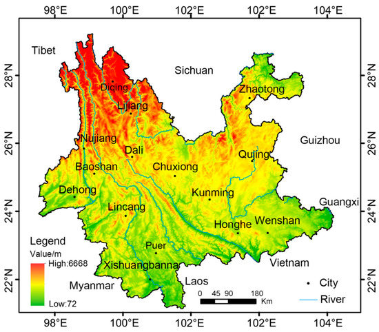
Figure 1.
The study area.
2.2. Data Sources
The data sources of this research are as follows:
- (1)
- Vector data of the spatial distribution of village settlements in Yunnan Province (2020) came from the Geographic Information Network (bbs.3s001.com). The information released by the official websites of the Ministry of Civil Affairs, National Bureau of Statistics, and Yunnan Provincial Bureau of Statistics were collated into text format, and their latitude and longitude data were obtained through geographic information processing and transformed into shape vector data.
- (2)
- Vector data of the provincial administrative boundary of Yunnan are from the National Basic Geographic Information Centre in shape format.
- (3)
- Yunnan DEM data (30 m resolution) are from NASA’s ASTER GDEM 30 m, obtained by cropping and extracting Yunnan administrative boundary vector shape data using the Gee platform.
2.3. Research Methodology
2.3.1. Analysis of the Distribution Characteristics of Rural Settlements
To explore the distribution pattern, direction, and density of rural settlements in Yunnan Province at the horizontal level, three indices including the Average Nearest Neighbor Index (ANN), Standard Deviation Ellipse (SDE), and Kernel Density Estimation (KDE) were processed in the Arc GIS operating platform (Table 1). The Average Nearest Neighbor Index (ANN) is used to identify the clustering of rural settlements in the area, based on the calculation of the average distance between rural settlement points and their nearest neighbors. The Standard Deviation Ellipse (SDE) is a method for quantifying the direction of the spatial distribution of geographical elements from a global, spatial perspective [37]. Kernel density estimation is a statistical method of non-parametric density estimation to discriminate the distribution density of rural settlements.

Table 1.
Research Methodology.
2.3.2. Selection of Topographic Factors
Topography is one of the most important factors influencing land-use patterns in mountainous regions and directly affects the spatial pattern of rural settlements. Based on the existing studies [39,40,41], six topographic factors, namely elevation, slope and aspect, relief amplitude, incision depth, and surface roughness, were selected for exploration on the basis of existing studies. Each rural settlement was assigned a geographic attribute value by the value extraction to the point method. In the Origin platform, mathematical statistics were conducted to obtain a histogram of the number of rural settlement distributions in Yunnan Province and the frequency map, and the cumulative frequency curve was initially drawn to explore the distribution of rural settlements on different topographic factors. The quantitative differences in the distribution of rural settlements on different topographic environmental factors were obtained.
2.3.3. Distribution Index Method
In order to describe the distribution and aggregation of rural settlements on different topographic positions, this paper introduces the concept of the distribution index, which is calculated by the following formula:
In the formula, denotes the number of rural settlements on class e of the terrain location and N denotes the total number of rural settlements in the study area. denotes the area of land on the class e of the terrain and S denotes the total area of the study area.
Residents’ choice of sites for settlements is influenced by topography; therefore, the sites of rural settlements are not randomly distributed. If P > 1, it means that the distribution of rural settlements in a topographic location is dominant, i.e., the topographic location is dominant for the distribution of rural settlements. A larger value indicates that the topographic location is more likely to be selected by residents. In contrast, P < 1 indicates that the type of terrain does not have the advantage of attracting residents to choose settlements.
3. Results and Analysis
3.1. Rural Settlements and Topographical Distribution Features in Yunnan Province
3.1.1. Characteristics of the Distribution of Rural Settlements
The distribution characteristics of rural settlements in Yunnan Province are studied from three perspectives: Distribution pattern, distribution direction, and distribution density. Figure 2a is the distribution direction diagram of rural settlements, and Figure 2b is the distribution density diagram of rural settlements.
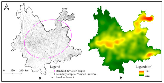
Figure 2.
Distribution direction and density of rural settlements in Yunnan Province.
- (1)
- The distribution of rural settlements in Yunnan Province shows a typical clustering-distribution pattern. The average nearest neighbor index (ANN) of rural settlements in Yunnan Province was 0.65, and the normalized z-value was −255.23. This indicates that the overall clustering pattern of rural settlements in Yunnan Province is very obvious due to the fact that the mountainous terrain in Yunnan accounts for 94% of the area and the dam area for 6%. People tend to choose the flat dam areas when selecting sites for settlements, so the settlements are more densely distributed in the dam areas with less area.
- (2)
- Rural settlements in Yunnan Province are distributed throughout the country as shown in Figure 2a, generally in a northeast–southwest direction, forming a dense belt of rural settlements across Yunnan Province. The area covered by this dense belt is the economically well-off cities of Yunnan Province, which are also more suitable for human habitation, the main cities being Kunming, Zhaotong, Chuxiong, and Baoshan.
- (3)
- From the distribution density of rural settlements in Figure 2b, the distribution density of rural settlements in Yunnan Province is dense in the northeast, sparse in the northwest, dense in the middle, and sparse in the south. The overall low density, fragmentation, and dotted distribution of high-value areas show three typical core areas, and the spatial differentiation is very obvious. The Yunnan plateau-mountain environment has an impact on rural settlement densities, which are generally low in Yunnan Province, with most places having a density value of 0. The high-density-value distribution is primarily observed in three core regions, one is the northwest Yunnan region with Zhenxiong as the core, one is the western Yunnan region with Baoshan, Dali, and Chuxiong as the core, and one is the southeast Yunnan region with Wenshan as the core. Regarding Zhenxiong in particular, Zhenxiong is located at the border of three provinces and has been a transportation hub since ancient times, which has led to the formation of a large number of rural settlements. Taking 50 km as the search radius, the highest density value in the core area of Yunnan Province is only 1.2/km2, which is obviously low compared to the density of rural settlements in the plain area, which can be as high as 10/km2. The distribution pattern of rural settlements is very fragmented due to the undulating topography and high fragmentation of the terrain in Yunnan. The distribution of rural settlements shows two main distribution patterns, one in the form of clusters in dam areas with good terrain and good topographical conditions for human habitation. Another one is that, given the limited area of the dam area, people choose areas with suitable altitudes and close to water sources where the soil and water conditions are favorable and the terrain is relatively flat, and the distribution of settlements is scattered, banded, or radial, such as the Lancang River basin, the Nu River basin, and the Red River. For example, the rural settlements in the Lancang, Nujiang, and Red River valleys all have a large number of settlements along the banks of the river valleys.
3.1.2. Terrain Distribution Characteristics
As can be seen from Figure 3d, the areas with the largest Relief Amplitude in Yunnan Province are mostly located in the canyon areas on both sides of the rivers, such as three parallel rivers in Yunnan’s protected areas, as well as the northeast of Yunnan, the border between Yunnan province and Sichuan province, both sides of the Jinsha River, and partly on both sides of the Yuanjiang River, with the highest value of relief amplitude reaching 1535 m, which is a significant feature of the mountainous terrain of the Yunnan plateau with a great vertical drop. The distribution of incision depth is similar to the distribution of the relief amplitude, with the deepest incision depth reaching 815 m, and the surface is severely cut by erosion. Surface roughness is a response to the degree of local surface flatness, and the lower its value, the flatter it is. The surface roughness does not show obvious regional differentiation at the provincial level, and the high and low values are cross-distributed, indicating that the topographic conditions are complex throughout the Yunnan Province, and the plain features are not obvious, and even in the dam area, they are still high and undulating.

Figure 3.
Distribution of topographic factors in Yunnan Province.
In general, Yunnan Province has a complex topography with high altitude and mountainous terrain. The terrain is bounded by the Yuanjiang valley and the wide valley in the southern part of the Yunling mountain chain and is divided into two major topographic areas in the east and west. The eastern part is the plateau of eastern and central Yunnan, which is characterized by gently undulating low mountains and rounded hills; the western part is the longitudinal valley area of the Hengduan mountain chain, with high mountains and deep valleys, a large relative height difference, and treacherous terrain, with elevations generally ranging from 1500–2200 m, and in the north from 3000–4000 m, with a high degree of topographic complexity on both sides of the river valley.
3.2. Correlation Analysis of the Distribution of Rural Settlements and Topography in Yunnan Province
3.2.1. Correlation Analysis of the Distribution of Rural Settlements with Elevation, Slope, and Aspect
- (1)
- The altitude distribution of rural settlements is shown in Figure 4a. The distribution of rural settlements in Yunnan Province presents a normal distribution, with 50% of rural settlements distributed below 1600 m above sea level and 30% of rural settlements distributed in the range of 1600 m to 2000 m. The vertical gradient of the distribution of village settlements shows a diamond shape with a narrow top and a wide bottom. According to the visualization of rural settlements in Yunnan Province classified according to the interval of 200 m in height difference shown in Figure 4a, it can be found that the rural settlements distributed in the interval of 1800 m to 2000 m are the largest. Altitude is an important factor affecting the distribution of rural settlements. The number of village settlements gradually increases as the altitude rises and then decreases after reaching a certain altitude. The higher the altitude, the lower the air pressure, and therefore, the less suitable the human living environment. According to Yang Haiyan [42], an area with an altitude greater than 2800 m is no longer suitable for ordinary people. Combined with the actual situation of the mountainous terrain of the Yunnan Plateau, 3000 m is the threshold of the rural settlement layout in Yunnan Province. However, there are still some rural settlements in Yunnan Province distributed below 500 m above sea level and above 3000 m, primarily in the northern part of Kunming, the southern mountains of Zhaotong, and northwestern Yunnan, where the environment is harsh, the air is thin, the ecology is fragile, the water and soil conditions are poor, and the transportation infrastructure is poor. Therefore, the development and construction of such areas are difficult and unsuitable for human habitation, and settlements under such conditions should receive more attention.
 Figure 4. Statistical map of the distribution of rural settlements in Yunnan Province.
 - (2)
- The distribution of the rural settlement slope is shown in Figure 4b. There are 50% of the rural settlements distributed within the interval of 0°–11.39°. Approximately 35% of rural settlements are between 15° and 25°, and 5% of settlements are larger than 25°. In the plains, most rural settlements are distributed in the 0–8° range, but in Yunnan, the largest number of rural settlements are distributed in the 8–15° range, which is determined by the natural geographical conditions of the mountainous areas. According to the National Standard Classification of Arable Land Slopes [43] (the standard classification of arable land slopes includes five grades, namely 0°–2°, 2°–6°, 6°–15°, 15°–25°, and above 25°, which are considered flat, small, medium, large, and very large slopes, respectively), slopes greater than 25° are seriously unsuitable for agricultural production and it is extremely difficult to build infrastructure and public services on such land. The slope value of 25° is a critical value for the distribution of rural settlements in Yunnan Province. This part of Yunnan has far worse land conditions than other regions, and the author’s field research in some of the more steeply sloping rural settlements revealed that residents are constantly adapting to such slope conditions when creating settlements.
- (3)
- The distribution of the rural settlement aspect is shown in Figure 4c. Rural settlements in Yunnan province account for approximately 24% of the north-facing rural settlements, 27% of the south-facing rural settlements, 25% of the east-facing rural settlements, and 23% of the west-facing rural settlements, which means that rural settlements in Yunnan province are evenly distributed in all directions and do not differ much, with the south-facing rural settlements accounting for approximately 3% more than the north-facing rural settlements. This suggests that slope orientation has little influence on the distribution of settlements in Yunnan.
3.2.2. Correlation Analysis of the Distribution of Rural Settlements with the Relief Amplitude, Incision Depth, and Surface Roughness
- (1)
- The distribution of rural settlement relief amplitude and incision depth is shown in Figure 4d,e. Under the effect of two topographic parameters, topographic relief and the depth of surface cut, the distribution of rural villages is comparable at the regional level. The number of rural settlements has a trend of first increasing and then rapidly decreasing as the values of the topographic relief and surface cut depth increase. Furthermore, 50% of rural settlements are located below 112 m in terms of the topographic element of relief amplitude and 50% of rural villages are located below 49 m, according to the topographic factor of incision depth. This suggests that people choose to settle in lower elevations when living in hilly areas. However, some rural settlements still opt to reside at high altitudes with significant undulations and deep cuts due to the conditions of surrounding land use. Two examples are Tangdui Village and Tongle Village, which have been studied by the author in the field.
- (2)
- The surface roughness can reflect the local topographic features. From Figure 4f, we can see that 50% of the village settlements are distributed in the range of 1–1.0159, and almost all of the village settlements are distributed in the surface roughness value of 1.2 or below. When the surface roughness value is greater than 1.2, there are few rural settlements. The surface roughness reflects the local surface flatness, and a flat surface is more conducive to the daily production work of residents and the construction of dwellings, which is an important consideration in the site selection of settlements.
3.2.3. Distribution Index
Using a distribution index, this study investigates the relationship between topography and the distribution of rural settlements in Yunnan Province. Each topographic factor is categorized hierarchically in accordance with the topographic features of the study area, and the land area share of various topographic positions is obtained using the GIS spatial analysis reclassification function. Additionally, the number of rural settlements distributed in different topographic positions is obtained using the excel statistical function. The results are displayed in Table 2.
Table 2.
Topographic classification and rural settlement statistics in Yunnan Province.
We can observe from Table 2 that the topographic factors in Yunnan Province are unevenly distributed. In terms of elevation, it is primarily distributed in the 1000–2500 m range, accounting for 75.59% of the total area, reflecting the characteristics of a plateau; the slope is primarily greater than 10°, accounting for 80.39% of the total area, showing the typical characteristics of mountains. The area of each slope orientation, with the exception of the flatlands, is generally balanced in terms of slope direction, with the north and south slopes accounting for a larger proportion, 25.71% and 27.05%, respectively; the relief amplitude in the range of 95–241 m accounts for 60.21%; the incision depth 0–128 m accounts for 82.49%; and the surface roughness is primarily concentrated between 1.0 and 1.1, accounting for 66.16%. The complicated topography of the mountains of the Yunnan Plateau is explained by a combination of these six topographic characteristics.
Unevenness can also be seen in the distribution of rural settlements in Yunnan Province. The number of rural settlements exhibits a phenomenon of increasing and then decreasing with the increase in topographic level for the three topographic parameters of elevation, slope direction, and slope gradient. With an increase in the topographic level, there is a tendency for the number of rural villages to decline due to the topographic characteristics of relief amplitude, incision depth, and surface roughness. At high-level terrain sites, the number of rural settlements appears to drop off suddenly, especially for the terrain component of terrain roughness.
In order to study the distribution advantages of rural settlements on various terrain types and the relationship between them and the terrain, the distribution indices of rural settlements on various levels of terrain are calculated and plotted as shown in Figure 5.
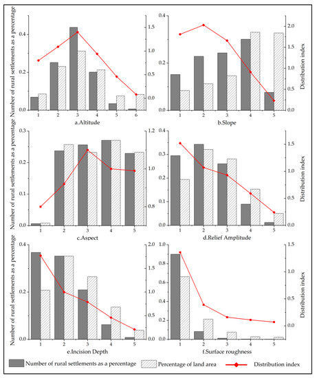
Figure 5.
Distribution Index of Rural Settlements in Yunnan Province.
The distribution index value for the topographic factor of elevation appears to climb first and then decline, similar to a “pyramid,” as can be seen in Figure 5a. Rural settlements in Yunnan Province are best situated topographically between 1500 and 2000 m, with a distribution index value of 1.4, and between 1000 and 1500 m, with a distribution index value of 1.09. The number of rural settlements will eventually decline since the severity of the natural conditions and the inconvenience of transportation increase with altitude.
The ideal topographic position for the topographic factor of the slope is 5°–10°, and distribution indices of 0°–5° and 10°–15° also surpass 1. In general, a slope’s suitability for housing construction and infrastructure placement increases with slope size, which lowers development costs. However, the sites of 0°–5° are often used as town construction sites, so the distribution index of rural settlements is small. However, with the increase in slope value, the rural settlement distribution index obviously shows a decreasing trend, which indicates that the larger the slope, the more unsuitable for human habitation, and the corresponding topographic location will not be chosen by residents.
The slope orientation topographic component did not demonstrate any significant divergence. East-facing slopes and south-facing slopes have distribution indices that are greater than 1, indicating that these two topographic orientations are dominant. The choice of a suitable location for a traditional settlement should take good illumination into account. The occupants’ need for sunlight can be satisfied by either the east-facing slope or the south-facing slope, both of which are sunny slopes. For instance, the majority of the communities on Dali Erhai’s west shore are located on the east slope.
The distribution of rural settlements demonstrated a distinct divergence phenomenon for the three topographic parameters of topographic relief, surface cut depth, and surface roughness. Topographic relief distribution indices over 1 are 0–95 m and 95–166 m; surface cut depth distribution indices over 1 are 0–45 m and 45–86 m; and surface roughness distribution indices over 1 are 1.0–1.1. This indicates that in order to minimize development costs while also achieving the optimum living circumstances, residents of rural settlements choose the location with soft and uncomplicated topography for development and construction. However, given the varied topography of the plateau-mountain region, certain towns will inevitably be located in less favorable topographic settings. Nevertheless, a set of guidelines for topographic adaptation has been compiled.
3.3. Coupling Mechanisms
According to empirical research and literature [44,45], Figure 6 is drawn, and it can be seen that people often choose a settlement site close to a water source, with flat terrain, a suitable climate, and easy access to the original settlement. However, not all settlements can be created in an ideal location [46]. Yunnan’s special natural geography has created a unique topographic landscape with many mountainous areas, few dam areas, obvious vertical zone differentiation, frequent disasters, and difficulties in development and construction. The inhabitants have adapted to the natural environment in terms of the street system, the way dwellings are built, and the selection of building materials, thus forming an internal mechanism that couples the distribution of the village settlements with the topography. For example, while Tongle Village was created with a fishbone road system to ensure the smoothness of the roads, Chengzi Village was created with flat roofs, which evolved into informal roads within the village where one could walk on the roofs. At the same time, to solve the problem of less arable land due to the excessive slope, the flat roofs were also used as drying grounds for each family to maximize the use of space. These examples show the ecological adaptability of rural settlements, reflecting the rich creative wisdom of local residents in Yunnan Province.

Figure 6.
The mechanism of topography influencing settlement distribution.
4. Discussion
The distribution of settlements is influenced by natural, social, and human factors. To a large extent, it is affected by the topography of the natural elements. The complex terrain makes it more difficult to develop and build up the natural environment. This study analyzes the correlation between the distribution of rural settlements in Yunnan Province and six topographic factors and obtains the extent to which the distribution of rural settlements is influenced by topography. Under the influence of the plateau-mountainous terrain, although people prefer relatively flat places or flat areas with river valleys to create settlements, there are still a large number of settlements located in uninhabitable areas with steep terrain and high altitudes as constraints of real conditions force them to adapt. In practice, attention should be paid to these rural settlements to assess their ecological adaptability and to protect these valuable settlements. However, at the same time, attention should also be paid to the influence of social factors on the distribution of rural settlements, such as a large number of rural settlements in Zhenxiong County, which are inseparable from the local location of the border between the three provinces and the transportation factor. It is only when the driving factors of the distribution of rural settlements are identified that the right policies can be formulated to guide the development of rural work and the early optimization and development of rural settlements in Yunnan Province.
5. Conclusions
Based on mathematical statistics and visualization, this research analyzes the correlation between rural settlements and topography in Yunnan Province, explores the inner mechanism of topographic factors affecting the distribution of rural settlements, and draws the following conclusions:
- (1)
- The distribution pattern of rural settlements in Yunnan Province is dense in the northeast, sparse in the northwest, dense in the middle, and sparse in the south; the overall pattern shows low density, fragmentation, and a dotted distribution of high-value areas, showing three typical core areas with very obvious spatial differentiation. The site distribution of rural settlements is obviously different from that of the plain area settlements, with regional characteristics of plateau-mountain terrain.
- (2)
- In Yunnan Province, the distribution of rural settlements is influenced by three key topographic factors: Relief amplitude, incision depth, and surface roughness. The dispersion index of rural settlements drastically declines as the value rises. There are still settlements distributed in the terrain with an elevation greater than 3000 m and a slope greater than 25° in the study area. The layout of this part of the rural settlement should be further optimized.
- (3)
- Different topographic factors affect the production and living conditions of residents by influencing temperature, air pressure, arable area, land leveling degree, etc. By coupling these factors with the psychological needs of villagers, the inner mechanism of the plateau mountainous terrain affecting the distribution of rural settlements is formed.
Topography is an important factor when developing and constructing in plateau-mountain areas. The environmental protection and construction of human settlements should be in accordance with nature and adapted to the terrain, which can reduce the damage to the natural environment.
Author Contributions
Conceptualization, J.X. and L.Z.; methodology, L.Z.; software, L.Z.; validation, L.Z. and H.T.; formal analysis, L.Z. and R.M.; investigation, L.Z.; resources, L.Z.; data curation, L.Z. and H.T.; writing—original draft preparation, L.Z.; writing—review and editing, J.X. and R.M.; visualization, L.Z.; supervision, J.X.; project administration, R.M.; funding acquisition, J.X. All authors have read and agreed to the published version of the manuscript.
Funding
The research was funded by the National Natural Science Foundation of China (Grant No. 51878591) and the 13th postgraduate scientific research innovation project of Yunnan University (Grant No. 2021Z081).
Institutional Review Board Statement
Not applicable.
Informed Consent Statement
Written informed consent has been obtained from the patient(s) to publish this paper.
Data Availability Statement
Data used in this study will be available upon request from the first author.
Conflicts of Interest
The authors declare no conflict of interest.
References
- Wu, C.J. On the territorial system of human-land relations, the core of geography. Econ. Geogr. 1991, 3, 1–6. (In Chinese) [Google Scholar]
- Qu, Y.B.; Wei, S.W.; Shang, R.; Zheng, J. Spatial pattern identification of rural settlements based on “point-surface” characteristics. Resour. Sci. 2019, 41, 1035–1047. (In Chinese) [Google Scholar]
- Zhang, T.Z.; Zhang, F.R.; Xie, Z.; Huang, J.W. Spatial pattern evolution of rural settlements in Yunnan minority mountainous areas in the context of precise poverty alleviation. Trans. Chin. Soc. Agric. Eng. 2019, 35, 246–254. (In Chinese) [Google Scholar]
- Mao, Q.H. Study on the spatial characteristics and pattern optimization of rural settlements in Zhejiang Province in the context of beautiful countryside—Taking Zhejiang Province as an example. J. China Agric. Resour. Reg. Plan. 2021, 42, 150–157. (In Chinese) [Google Scholar]
- Li, S.J.; Xu, J.W.; Hai, B.B. Analysis of the evolution of the distribution pattern of county settlements--an empirical study based on Gongyi, Henan, 1929–2013. Acta Geogr. Sin. 2015, 70, 1870–1883. [Google Scholar]
- Hu, Z.; Chen, K.X.; Xie, X.F. A Graph Neural Network (GNN) Algorithm for Constructing the Evolution Process of Rural Settlement Morphology. Secur. Commun. Netw. 2022, 2022, 7517347. [Google Scholar] [CrossRef]
- Nandi, S.; Mistri, T. Transformation of rural settlement in Salanpur community development block, West Bengal, India. GeoJournal 2022, 88, 291–318. [Google Scholar] [CrossRef]
- Zhou, J.Z.; Hou, Q.H. Resilience assessment and planning of suburban rural settlements based on complex network. Sustain. Prod. Consump. 2021, 28, 1645–1662. [Google Scholar] [CrossRef]
- Yue, Q.B.; He, J.H.; Liu, D.F. Identifying Restructuring Types of Rural Settlement Using Social Network Analysis: A Case Study of Ezhou City in Hubei Province of China. Chin. Geogr. Sci. 2021, 31, 1011–1028. [Google Scholar] [CrossRef]
- Heng, J.Y.; Wang, H.W.; Fan, Y.; Wang, Z.W.; Gao., Y.B. Simulation and Optimization of Urban–Rural Settlement Development from the Perspective of Production–Life–Ecology Space: A Case Study for Aksu City. Sustainability 2021, 13, 7452. [Google Scholar] [CrossRef]
- Whatmore, S. Sustainable rural geographies. Prog. Hum. Geogr. 1993, 17, 538–547. [Google Scholar] [CrossRef]
- Yu, X.; Zhao, Z. Fractal Characteristic Evolution of Coastal Settlement Land Use: A Case of Xiamen, China. Land 2022, 11, 50. [Google Scholar] [CrossRef]
- Li, X.; Li, H.; Zhang, Y.; Yang, L. Spatial Patterns and the Regional Differences of Rural Settlements in Jilin Province, China. Sustainability 2017, 9, 2170. [Google Scholar] [CrossRef]
- Zhang, Y.; Wang, P.; Wang, T.; Cai, C.; Li, Z.; Teng, M. Scenarios Simulation of Spatio-Temporal Land Use Changes for Exploring Sustainable Management Strategies. Sustainability 2018, 10, 1013. [Google Scholar] [CrossRef]
- Shao, N. Analysis of spatial distribution characteristics and driving forces of rural settlements in Nanyang City. J. China Agric. Resour. Reg. Plan. 2020, 41, 220–225. [Google Scholar]
- Zhang, J.; Gu, P. Analysis of spatial distribution characteristics and influencing factors of rural settlements in Northeast China. J. China Agric. Resour. Reg. Plan. 2019, 40, 110–115. [Google Scholar]
- Song, W.; Li, H.H. Spatial pattern evolution of rural settlements from 1961 to 2030 in Tongzhou District, China. Land Use Pol. 2020, 99, 105044. [Google Scholar] [CrossRef]
- Ji, H.W.; Cha, X.C. A study on the spatial evolution characteristics of rural settlements in the eastern Qinling Mountains and their influencing factors: An example from Danfeng County, Shangluo City. J. Ecol. Rural. Environ. 2022, 38, 32–42. [Google Scholar]
- Huang, D.K.; Sun, W.; Chen, W.; Zhang, Y.Z. Study on the evolution and mechanism of village and town settlement patterns based on multi-temporal remote sensing data--Jiangsu Province as an example. Resour. Environ. Yangtze Basin 2021, 30, 2405–2416. [Google Scholar]
- Luo, G.; Wang, B.; Luo, D.; Wei, C. Spatial Agglomeration Characteristics of Rural Settlements in Poor Mountainous Areas of Southwest China. Sustainability 2020, 12, 1818. [Google Scholar] [CrossRef]
- Tan, S.K.; Zhang, M.M.; Wang, A.; Ni, Q.L. Spatio-Temporal Evolution and Driving Factors of Rural Settlements in Low Hilly Region—A Case Study of 17 Cities in Hubei Province, China. Int. J. Environ. Res. Public Health 2021, 99, 2387. [Google Scholar] [CrossRef] [PubMed]
- Ma, L.; Guo, X.; Tian, Y.; Wang, Y.; Chen, M. Micro-Study of the Evolution of Rural Settlement Patterns and Their Spatial Association with Water and Land Resources: A Case Study of Shandan County, China. Sustainability 2017, 9, 2277. [Google Scholar] [CrossRef]
- Yin, J.B.; Li, H.; Wang, D.Y.; Liu, S.H. Optimization of Rural Settlement Distributions Based On the Ecological Security Pattern: A Case Study of Da’an City in Jilin Province of China. Chin. Geogr. Sci. 2020, 30, 824–838. [Google Scholar] [CrossRef]
- He, R.W. Urban-rural integration and rural revitalization: Theoretical discussion, mechanism interpretation and realization path. Geogr. Res. 2018, 37, 2127–2140. [Google Scholar]
- Gong, J.Z.; Jian, Y.Q.; Chen, W.L.; Liu, Y.; Hu, Y. Transitions in rural settlements and implications for rural revitalization in Guangdong Province. Rural Stud. 2019, 93, 359–366. [Google Scholar] [CrossRef]
- Yang, R.; Liu, Y.S.; Long, H.L.; Chen, C.G. Geographical element identification of spatial and temporal characteristics and spatial directionality of rural settlement sites based on a grid—Taking the Bohai Sea Rim region as an example. Geogr. Res. 2015, 34, 1077–1087. [Google Scholar]
- Long, H.L.; Liu, Y.S.; Zou, J. Rural development types and their rurality evaluation in eastern coastal areas of China. Acta Geogr. Sin. 2009, 64, 426–434. [Google Scholar]
- Wu, Y.K.; Luo, J.; Luo, M.H.; Tian, L.L.; Jiang, L.; Chen, S.Y. A study on the spatial pattern of rural settlements around metropolitan areas: Wuhan City as an example. Resour. Environ. Yangtze Basin 2022, 31, 37–48. [Google Scholar]
- Zhu, S.Y.; Kong, X.S.; Jiang, P. Identification of the human-land relationship involved in the urbanization of rural settlements in Wuhan city circle. China J. Rural Stud. 2020, 77, 75–83. [Google Scholar] [CrossRef]
- Lin, J.P.; Lei, J.; Wu, S.X.; Yang, Z.; Li, J.G. Spatial distribution characteristics of rural settlements in Xinjiang Oasis and its influencing factors. Geogr. Res. 2020, 39, 1182–1199. [Google Scholar]
- Tian, D.R.; Tang, H.; Tan, J.B. Study on the suitable spatial pattern of settlements in the hilly and ravine areas of the Loess Plateau in northern Shaanxi Province: The case of Donggou, Mili County. Arid. Land Geogr. 2022, 45, 263–276. [Google Scholar]
- Chen, S.; Mehmood, M.S.; Liu, S.; Gao, Y. Spatial Pattern and Influencing Factors of Rural Settlements in Qinba Mountains, Shaanxi Province, China. Sustainability 2022, 14, 10095. [Google Scholar] [CrossRef]
- Fan, X.; Luo, W.X.; Yu, H.R.; Rong, Y.; Gu, X.; Zheng, Y.; Ou, S.; Tiando, D.S.; Zhang, Q.; Tang, G.; et al. Landscape Evolution and Simulation of Rural Settlements around Wetland Park Based on MCCA Model and Landscape Theory: A Case Study of Chaohu Peninsula, China. Int. J. Environ. Res. Public Health 2021, 18, 13285. [Google Scholar] [CrossRef]
- Shahi, D.K. Distribution of rural settlements in the high himalayan region: A case study of har ki dun. ACADEMICIA Int. Multidiscip. Res. J. 2021, 11, 285–294. [Google Scholar] [CrossRef]
- Li, Y.Q.; Qi, W.; Wang, D.; Yan, Y.; Lu, C.; Wang, N.N.; Qin, T. A study on the distribution characteristics of rural settlements in mountainous counties with the support of GIS--Qixia City as an example. Geogr. Geogr. Inf. Sci. 2011, 27, 73–77. [Google Scholar]
- Xu, J. Adaptive Conservation and Construction of Habitat in Plateau-Mountain Areas; Science Press: Beijing, China, 2021. (In Chinese) [Google Scholar]
- Zhao, L.; Zhao, Z.Q. A study on the spatial differentiation of China’s economy based on characteristic ellipses. Sci. Geogr. Sin. 2014, 34, 979–986. [Google Scholar]
- Ren, P.; Hong, B.T.; Liu, Y.; Zhou, J.M. Study on Spatial Change Characteristics and Landscape Pattern of rural Settlements Based on RS and GIS. Acta Ecol. Sin. 2014, 34, 3331–3340. [Google Scholar]
- Xi, C.B.; Qian, T.L.; Chi, Y.; Chen, J.; Wang, J.C. Relationship between settlements and topographical factors: An example from Sichuan Province, China. J. Mt. Sci. 2018, 15, 2043–2054. [Google Scholar] [CrossRef]
- Wang, J.; Zhang, J.; Dai, W.; Zhang, H.P.; Zhou, L. Study on the spatial pattern of poverty and topographic influencing factors in counties on the Loess Plateau. Areal Res. Dev. 2020, 39, 30–35+52. [Google Scholar]
- Liu, Y.; Deng, W.; Song, X.Q. Relief Degree of Land Surface and Population Distribution of Mountainous Areas in China. J. Mt. Sci. 2015, 12, 518–532. [Google Scholar] [CrossRef]
- Yang, H.Y. Study on the Altitude Classification of Habitat Suitability in China. Master’s Thesis, Nanjing Normal University, Nanjing China, 2013. (In Chinese). [Google Scholar]
- TD/T 1014-2007; Technical Regulations for the Second National Land Survey. China Standard Press: Beijing, China, 2007.
- Yang, X.; Pu, F. Spatial Cognitive Modeling of the Site Selection for Traditional Rural Settlements: A Case Study of Kengzi Village, Southern China. J. Urban Plan. Dev. 2020, 146, 05020026. [Google Scholar] [CrossRef]
- Yang, G.Q. Characteristics of Spatial Wholeness of Traditional Settlements in China and Their Sociological Significance. J. Tongji Univ. 2014, 25, 60–68. [Google Scholar]
- Ying, L.; Wei, D.; Li, P. The coupling mechanism between the suitable space and rural settlements considering the effect of mountain hazards in the upper Minjiang River basin. J. Mt. Sci. 2020, 17, 2774–2783. [Google Scholar]
Disclaimer/Publisher’s Note: The statements, opinions and data contained in all publications are solely those of the individual author(s) and contributor(s) and not of MDPI and/or the editor(s). MDPI and/or the editor(s) disclaim responsibility for any injury to people or property resulting from any ideas, methods, instructions or products referred to in the content. |
© 2023 by the authors. Licensee MDPI, Basel, Switzerland. This article is an open access article distributed under the terms and conditions of the Creative Commons Attribution (CC BY) license (https://creativecommons.org/licenses/by/4.0/).