Article

Assessing and Understanding Arsenic Contamination in Agricultural Soils and Lake Sediments from Papallacta Rural Parish, Northeastern Ecuador, via Ecotoxicology Factors, for Environmental Embasement

by
Paul Andres Jimenez Jimenez
1,2,*,
Ximena Díaz
3,
Marx Leandro Naves Silva
1,
Anyela Vega
1,4 and
Nilton Curi
1
1
Department of Soil Science, Federal University of Lavras (UFLA), Lavras 37200-900, Brazil
2
Faculty of Geology and Petroleum, Escuela Politécnica Nacional, Ladrón de Guevara E11-253, Quito 170525, Ecuador
3
Department of Extractive Metallurgy, Escuela Politécnica Nacional, Quito 170525, Ecuador
4
Laboratorio de Contaminantes Orgánicos y Ambiente del IINDEP de la Universidad Nacional de Moquegua, Moquegua 18611, Peru
*
Author to whom correspondence should be addressed.
Sustainability 2023, 15(5), 3951; https://doi.org/10.3390/su15053951
Submission received: 2 December 2022 / Revised: 11 January 2023 / Accepted: 3 February 2023 / Published: 22 February 2023

Abstract

:
The concentration of arsenic (As), considered a toxic and carcinogenic metalloid, in agricultural soils has become a global challenge. Sources of arsenic in soils can be both anthropogenic and natural. Contaminated water is used for the irrigation of crops and vegetables, and therefore it is the main pathway for arsenic to enter the human food chain, creating a potential health risk. This study evaluated the concentrations of arsenic in agricultural soils in the rural parish of Papallacta, located 67 km east of the city of Quito, Northeastern Ecuador, and constitutes an analysis of the problem of arsenic in agricultural soils. Shallow groundwater and geothermal water discharges laced with arsenic are frequently used for irrigation and have raised the level of arsenic in agricultural soils. This work is focused on evaluating the environmental quality and contamination of agricultural soils through environmental quality indices such as geo-accumulation index, enrichment, and contamination factor. The average arsenic levels in the agricultural soils of the four studied areas fluctuate between 20.4 and 43.0 mg kg−1, while in the sediments of the Papallacta Lake, higher values were found in the range between 16.8 and 102.4 mg kg−1; all of which exceed the permissible limit by the Ecuadorian Environmental Legislation for agricultural use (12 mg kg−1). The results of the study in the five studied sites of the Papallacta civil parish indicate low to moderate levels of arsenic enrichment, soils enriched by bedrock, and moderate to considerable contamination.

1. Introduction

Arsenic is a metalloid listed in group VA of the periodic chart. It exists in nature in the oxidation states +V (arsenate), +III (arsenite), 0 (arsenic), and -III (arsine) [1].
Soils contain both organic and inorganic arsenic species. Inorganic As species include arsenite and arsenate, which are the most abundant forms found in the environment. The majority of As in aerated soils exist as H₂AsO₄ (acid soils) or HAsO₄2 (neutral species and basic). However, HAs₃O₃ is predominant in anaerobic soils [2].
The oxidation state and its mobility are fundamentally controlled by redox conditions (redox potential, Eh) and pH [3]. Arsenic migration is greatly limited due to the strong sorption by clays, hydroxides, and organic matter [4,5,6].
Arsenic is a well-known toxic and carcinogenic metalloid that occurs naturally in soil, aquifer, and sediments [7]. Elevated concentrations of arsenic have primarily resulted from natural sources, such as erosion and leaching from geological formations or anthropogenic sources. In addition, use of As for industrial purposes, and pesticides and fertilizers for mining and metal processing activities, are other major sources of contamination [8].
The distribution of arsenic is strongly related to areas of active plate tectonics, magmatism and associated hydrothermal activity, and high rates of erosion. Sources of arsenic contamination are mainly hydrothermal water, sulfide and arsenide minerals, volcanic ash, and iron oxyhydroxide/oxide as weathering products [9].
Arsenic has a great affinity to form or occur in many minerals, and of over 200 As-containing minerals, approximately 60% are arsenates, although As minerals and compounds are readily soluble [10].
Surface sediments and soils in various parts of the world contain higher and more variable concentrations, ranging from 2 to 20 mg kg1 on average, than the average crustal concentration [11]. Typically, the concentrations of As in non-contaminated soils vary from 0.1 to 10 mg kg1 [12]. Natural and anthropogenic sources contribute to the levels of arsenic found in soil and sediments. Average concentrations in soil are often around 5 mg kg1 but can range from 1 mg kg1 to up to 40 mg kg1. This variation in arsenic levels that occurs naturally in soils is associated with the presence of geological formations. Soils contaminated with arsenic from anthropogenic sources can have arsenic concentrations ranging from 5 to 3000 mg kg1 [13].
Arsenic exposure has likely been a longstanding problem in Latin America. Though this widespread contamination from both natural and anthropological sources has long been a threat to human health in Latin America, relatively little is known about occurrence, distribution, and exposed populations in countries other than Argentina, Brazil, Chile, and Mexico [14].
Arsenic-contaminated areas in Latin America (14 countries in Central and South America) are concentrated in the circum-Pacific region, where they are associated with the “Ring of Fire”. The arsenic sources in this area are related to magmatic activity (including volcanic, hot springs, fumaroles, and geothermal well, volcanic ash, and sulfide deposits [15].
Data for geothermal systems in Mexico, Guatemala, Honduras, El Salvador, Nicaragua, Costa Rica, Ecuador, Bolivia, and Chile are presented. Two sources of As can be recognized in the investigated sites: Arsenic partitioned into volcanic gases and emitted in plumes and fumaroles, and arsenic in the rocks of volcanic edifices that are leached by groundwaters enriched in volcanic gases [16].
In the Andean range, Chile, Bolivia, Peru, and Ecuador, As is predominantly released by weathering of volcanic rocks and sulfide ore deposits, and leaching of their weathering products [17]. Dissolution of volcanic rocks of the Andes contributes additional As to the overland flow and infiltrating water and transports it to the rivers and springs, respectively [18].
Ecuador has many volcanic centers and geothermal systems. Geothermal waters with high As concentrations are located in the northcentral Andean region of Ecuador and the basin of Papallacta Lake in Quijos County [16].
The arsenic content of geothermal hot springs and their sediments in the north-central Andean region of Ecuador has been investigated. The area of study includes five provinces: Carchi, Imbabura, Pichincha, Cotopaxi, and Tungurahua. The results indicate that the total arsenic in geothermal waters in this region has a range of 2–969 µg As L1, and sediments contain arsenic ranging from 1.6 to 717.6 mg kg1 [19].
In the central part of the Andean region, natural As is present in Papallacta Lake. Sediment samples taken on the eastern and southeastern of lake shores obtain relatively high arsenic (540 and 613 mg kg1) in contrast to the lower sediment As levels on the northwestern and southwestern margins (60 and 72 mg kg1) [16].
In addition to drinking water, food is another source of As in Latin American countries. A few studies from As endemic areas in Latin America have indicated that food contributes up to 50% of total As intake [20,21]. High amounts of As have been detected in fish, cow milk, grains, and vegetables including potato, onion, beet, pumpkin, radish, cabbage, and beans in Bolivia, Brazil, Chile, Ecuador, El Salvador, Honduras, Mexico, Nicaragua, and Peru. Cow milk from Argentina and Mexico are shown to have As [22].
Due to lack of agreement on the definition of soil quality, there is currently no general consensus regarding the soils that should be considered of maximum quality. The different approaches to the latter point can be summarized as two options. The first considers that a maximum quality soil is the soil in equilibrium with all the components of the environment, i.e., a climax soil developed under climax vegetation. The second option considers that the maximum quality reference soils are soils capable of maintaining high productivity and of causing minimum environmental distortion [23].
The population of Papallacta is considered exclusively rural, with a high dependence on food and water from local sources. In the study area, agricultural soils can also be contaminated with arsenic through the use of contaminated water for crop irrigation purposes, creating a potential risk for human health [24].
Food security attainment has been one of the most important sustainable development goals in most developing nations. Agricultural soil serves as a storage reservoir for water and nutrients needed for plants’ growth. Therefore, heavy metals contamination in agricultural soils can be harmful to normal plants’ growth [25].
The main objectives of this study are to assess the degree of As contamination in the agricultural soils of the Papallacta parish, environmental quality of soils, and ecological risk associated with the obtained levels of As using the enrichment factor (EF), contamination factor (CF), and geo-accumulation index (Igeo).
Ecological risk indices such as EF, CF, and Igeo have been conveniently employed as diagnostic tools by a number of researchers [26,27,28,29,30] for assessing the pollution status of arsenic and metals Pb, Cd, Ni, Fe, Cu, Mn, Co, and Zn contaminated agricultural soils and sediments.

2. Materials and Methods

2.1. Study Area

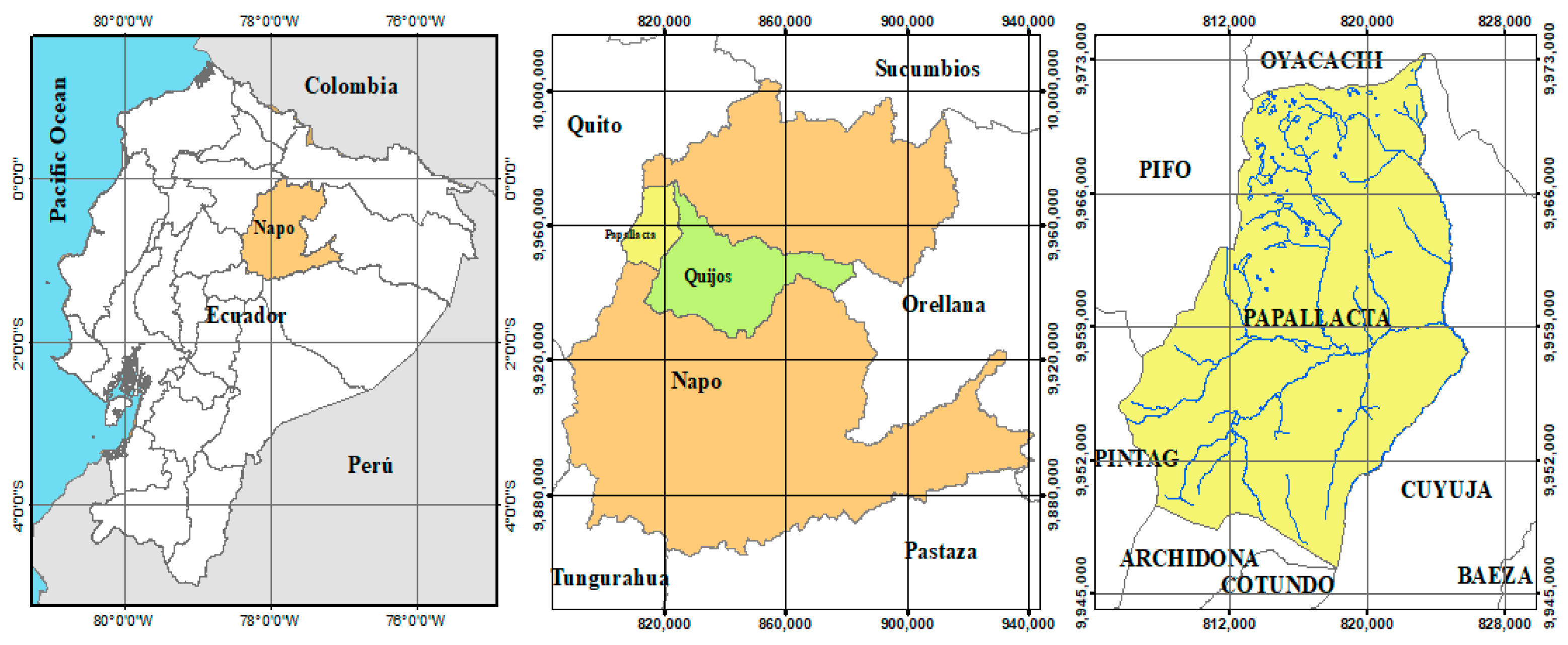
Papallacta is a rural parish located in Quijos County, Napo province, in northeastern Ecuador, 67 km east of Quito city (Figure 1). Altitudinally, it is located in the eastern range of the Andes Mountain at 3156 m above sea level; the parish has an area of 319.6 km2 [31].
The parish and its human settlements are located at altitudes that range from 2800 to 4500 m above sea level. The annual average precipitation is from 1000 to 1500 mm and the annual average temperature is 7–15 °C.
According to the Ecuador National Institute of Census Statistics [32], in the 2010 population census, the parish of Papallacta has a population of 920 inhabitants.

2.2. Geography, Geological and Soil Setting of Study Area

Papallacta in Ecuador is divided into five morphotectonic regions [33]: (1) the coastal lowlands, which is covered by Paleogene to Neogene forearc deposits, (2) the Western Cordillera, which is composed of mafic and intermediate volcanic and intrusive rocks, (3) the Interandean Depression, which lies east of the Western Cordillera and hosts thick Pliocene to Pleistocene volcanic deposits [34], (4) the Eastern Cordillera (Cordillera Real in Ecuador) is composed of Paleozoic metamorphic rocks and Mesozoic granitoids [35], and (5) the Oriente Basin, including the Subandean zone, is a Late Cretaceous–Holocene foreland basin that developed on the South American plate in response to growth of the Eastern Cordillera [36].
Papallacta parish is located on the crest of the Eastern Cordillera, in the central part of the Chacana Caldera, between the Antisana and Cayambe volcanoes.
The Chacana Caldera comprises the largest rhyolitic volcanic complex in the quaternary of the Northern Andes. This favors the presence of highly differentiated magmas emplaced at shallow crustal levels, which induce strong and consistent thermal anomalies in order to feed geothermal systems [37].
The Chacana Caldera is underlain by a complex metamorphic basement and both geologic regimes are affected by ongoing tectonic activity that includes NE-trending transpressive faulting as well as eastward-trending thrust faulting. The caldera’s dimensions are large: the N-S diameter across the entire structure measures 50 km and the E-W width is truncated but measures at least 30 km. Outward-sloping packages of ignimbrites, lava flows, and tuffs comprise the north, west, and southwest outer flanks [38].
The central depression is filled everywhere, first by ignimbrites, tuffs, and breccias of siliceous nature associated with the volcanism of the outer flanks, and later by post-collapse volcanism consisting of lava emissions of intermediate composition, and subsequently, by detrital sediments [38].
About 20 intracaldera volcanic vents of rock composition varying from acid andesites to dacites and to rhyolites are scattered in an area of 30 km (NS) and 7 km (EW) and have assumed ages of less than 450,000 years; the last eruption occurred only 240 years ago [37].
The Chacana Caldera has emitted two lava flows in the last 300 years. One of them is the Pinantura Flow, which is located on the outer flank of the caldera, and the other is the Papallacta Flow, which is located inside the caldera and forms the Papallacta Lagoon [39].
Furthermore, Palaeozoic and Precambrian gneisses and amphibolites occur in the Cordillera Real at Papallacta [40].
Andisols make up 94.93% of the parish area, while the rest of the area is represented by Histosols [31,41]. The main attributes of Andisols generally include a low degree of crystallinity minerals, high specific surface area, low bulk density values, high water-holding and infiltration capacity, and high contents of soil organic matter [42,43].

2.3. Sampling Site Description

The agricultural soil sampling was performed in four different districts (Cabecera Parroquial (S1), El Tambo (S2), Baños (S3), and (S4) Chalpi) of Papallacta parish (Figure 2), where agriculture (potatoes, beans, corn, vegetables) and grazing activities are the primary occupation of the area and farmers in the village use the arsenic contaminated water for various purposes, especially for irrigation.
Sediments sampling was carried out at Papallacta Lake (S5); discharges of geothermal waters are the main natural sources of arsenic in the lake.
Approximately 0.5 kg composite soil samples were collected at a depth of about 10–35 cm from the arable surface.
Table 1 details a summary of the characteristics of agricultural soils and sediments samples taken of the five sampling areas of Papallacta parish, referring to the type of soil and land use.
MAG-SIGTIERRAS, the Ecuadorian entity in charge of soil mapping for the entire continental territory, adopts the US Soil Taxonomy System (Soil Survey Staff, 2014), which has reached the level of suborders [44].
Most of the soil samples in the studied area correspond to the Andisol and Histosol order; according to the U.S. Soil Taxonomy System, Andisols soils derived from volcanic ejecta, especially volcanic ash, are characterized by high concentrations of OM [45].
The main soil’s parent material is represented by andesitic to rhyolitic volcanic products and ash deposits (sulfur, iron, aluminum). The Histosols connotate soils dominated by organic materials at different stages of decomposition. They tend to be poorly drained, have low bulk density values, and high-water retention capacity [42]. They occur only in S4 site (Table 1).
The topography of the Papallacta parish area is very rugged, with dominant slopes ranging from undulating to mountainous (4–64)% [31].

2.4. Sample Collection, Preparation, and Analysis

Agricultural soils (n = 30) and sediments samples from Papallacta lake (n = 6) were taken in the Papallacta parish area. The aim was to ensure that the composite sample better represented the selected field soil; collected samples were transported to the lab in sterile sealed polythene zipped bags for further processing and analysis.
The samples were kept in the shade for air drying for two to three weeks at room temperature. Air-dried soils were disaggregated, and any visible remains of organisms and debris were removed. The dried samples were then crushed in a mortar and passed through a 150 μm sieve to normalize particle sizes.
The total concentration of arsenic was analyzed by inductively coupled plasma-mass spectrometry (ICP-MS); the following operational phase was carried out.
In order to investigate the total concentration of As, each sample of homogenized soil (0.25 g) was digested in an aqua regia (4 mL) consisting of HNO3 and HCl (1 mL:3 mL) in digestion tubes and was heated at 70 °C on a shaker (brand, model) for 1 h.
After the digests cooled, 1 mL of the solution was extracted and deionized water (9 mL) was then added to the solution. An Agilent 7700 (Agilent Technologies, Tokyo, Japan) inductively coupled plasma mass spectrometer (ICP-MS) was used to determine the amount of As in digested sediment samples. The detection limit of As in solution matrix of the ICP-MS was 0.1 μg L−1.
For quality control, the precision and accuracy of the analytical methods were analyzed using a blank digest and standard reference materials (trace element, SRM 1643e) to verify the results of As in sediment. This Standard Reference Material (SRM) is primarily intended for use in evaluating methods used in the determination of trace elements. The SRM 1643e consists of approximately 250 mL of acidified water in a polyethylene bottle, which was sealed in an aluminized plastic bag to maintain stability. The SRM 1643e simulates the elemental composition of fresh water. Nitric acid is present at a concentration of approximately 0.8 mol/L to stabilize the trace elements and is used to verify the results of As in sediments. The certified values for arsenic in SRM 1643e are reported both as mass fractions (58.98 ± 0.70 µg/kg) and as mass concentrations (60.45 ± 0.72 µg/L). A certified value has the highest confidence in its accuracy, so all known or suspected sources of bias have been investigated and considered. The certified values are the average of the gravimetrically prepared values and a value determined by either inductively coupled plasma mass spectrometry (ICP-MS) or inductively coupled plasma optical emission spectrometry (ICP-OES) [46].
Standard reference material was analyzed every 20 samples during analysis to check ICP-MS accuracy. The SRM sample was digested after utilizing the same procedure as sediments and the results gave good recovery of up to 96%.

2.5. Data Analyses

The degree of contamination and enrichment of As in the agricultural soils of Papallacta and in the surface sediments of Papallacta Lake were evaluated using three ecological risk indices (EF, CF, and Igeo).
The data obtained for As in sediments and agricultural soils were compared with the sediment quality guidelines of the United States Environmental Protection Agency (USEPA) and with the permissible limits of As (12 mg kg−1) for agricultural soils proposed by the Ministry of Environment of Ecuador [47,48].

2.5.1. Enrichment Factor

Enrichment factor (EF) of arsenic in agricultural soils can distinguish metal pollution caused by indigenous sources of metal, anthropogenic activities, and combination of both [49]. The metals EF is a useful indicator reflecting the status and degree of environmental contamination [50].
The EF calculations compare each value with a given background level, either from the local site, using older deposits formed under similar conditions but without anthropogenic impact, or from a regional or global average composition [26,51].
The enrichment factor for each metal (arsenic) is calculated by dividing its ratio to the normalizing element (Fe) by the same ratio found in the chosen baseline Equation (1) [49]. Thus, EF is computed using the relationship below:
E F = M e / F e s a m p l e M e / F e b a c k g r o u n d
where (Me/Fe) sample is the ratio of As to Fe in the sample and (Me/Fe) background is the ratio of As to Fe concentrations in the background. In the study, the background concentration was taken from the control sites.
Iron was chosen as the reference element to normalize sediment As concentrations and to alleviate the variations produced by heterogeneous sediments. This is because Fe is the most abundant naturally occurring and highly refractory metal and the levels of Fe are not generally influenced by anthropogenic sources [26,52].
According to the value obtained in the relationship, the level of enrichment is characterized in seven proposed categories as shown in Table 2 [53].
The origin of the metal (arsenic) can be determined by means of the enrichment factor; Table 3 presents the characteristics of each interval of the EF [54].

2.5.2. Contamination Factor

Contamination factor (CF) is considered to be an effective parameter which monitors metal pollution over a period of time. The CF is the ratio obtained by dividing the concentration of each metal (arsenic) in the soil by the baseline or background value (concentration in unpolluted soil) [55].
The level of contamination of sediments by As expressed in terms of CF was calculated as Equation (2):
C F = C m s a m p l e C m b a c k g r o u n d
where, Cm sample is the concentration of As in sediments and Cm background is the background value of As.
Values of this index are divided into four categories according to Table 4 [56,57].

2.5.3. The Geo-Accumulation Index

The index of geo-accumulation (Igeo), originally introduced by Müller (1969), can be used to assess the environmental contamination status or current levels of metal concentrations compared with geochemical background concentrations or original pre-industrial concentrations in the soils [29,58].
The Igeo values were calculated for As using the Equation (3) of Muller (1969) [26,59,60]:
I g e o = log 2 C m s a m p l e 1.5 * C m b a c k g r o u n d
In the above equation, Cm sample is the concentration of arsenic in the present soil sample and Cm background is the background value of the same metal. The factor 1.5 has been used with reference to possible variations in the background value. For the classification of various degrees of contamination level, a total of seven classes were reported in the geo-accumulation index, Table 5 [7,61].

3. Results and Discussion

3.1. Concentrations of As

The concentrations of As and Fe in agricultural soils (n = 30) collected from the four sites (S1–S4) of Papallacta parish and sediments (n = 6) from Papallacta Lake (S5) are summarized in Table 6.
In this study, the average As concentration in 15 soil samples of S1 (Cabecera Parroquial), five from S2 (Baños), four from S3 (Chalpi), six from S4 (El Tambo), and six from Papallacta Lake in the Papallacta parish were 43 mg kg−1, 20.7 mg kg−1, 20.4 mg kg−1, 41.2 mg kg−1, 66.7 mg kg−1, respectively.
The usual range of total As in uncontaminated soil is 0.1–10 mg kg−1 [57]; the maximum permissible limit of As content for agricultural soil recommended by the Ministry of Environment of Ecuador is 12 mg kg−1 [47]. The permissible limits of arsenic in agricultural soil (20 mg kg−1) have been given by the Agency for Toxic Substances and Disease Registry (ASTDR-FAO) [62]; the European Union (EU) recommended that As in agricultural soil should not exceed 20 mg kg−1 [63].
The results obtained from the present study reveal that the average level of arsenic contamination in the four sites (S1-S4) and in the agricultural soils from the Papallacta parish exceed the permissible limits of agricultural land. Abnormally high concentrations of As with values ranging from 16 to 102 mg kg−1 were found in the sediments of Papallacta Lake. This result indicates that arsenic concentration in the site is fairly high.
Arsenic contamination of groundwaters is critical, not only regarding health problems, but also in aggravating crop production systems in arsenic hot spots in Bangladesh. The Bengal Delta Plain has become one of the most severely contaminated areas in the world [64]. In Bangladesh, irrigation is mostly dependent on groundwaters. Background levels of arsenic in soils vary from 4 to 8 mg As kg−1. In areas irrigated with contaminated water, the soil content may reach values up to 83 mg As kg−1, and reports have registered elevated As concentrations up to 57 mg As kg−1 in soils collected from four districts of Bangladesh [65], which are higher As concentration values than those reported in the agricultural soils of Papallacta, Ecuador.
Among the metals, the concentrations of Fe were highest in all 5 sites (S1, S2, S3, S4, S5). In agricultural soils and sediments of Papallacta, the concentration of Fe ranged from 8536.8 mg kg−1 to 45,895.4 mg kg−1. These concentrations of Fe exceeded the sediment-standard guidelines (17,000 mg kg−1) by the U.S. Environmental Protection Agency [66].
Arsenic occurs as a major constituent in more than 200 minerals, including elemental As, arsenides, sulphides, oxides, arsenates, and arsenites; the most abundant As ore mineral is arsenopyrite, FeAsS [10].
Numerous volcanoes, hot springs, and fumaroles occur in Papallacta. Geothermal surface manifestations are mainly used as medicinal baths in recreational complexes. However, owing to the lack of wastewater treatment facilities, the residual waters are commonly released to the surrounding water bodies (i.e., rivers and creeks) from which downstream water is taken for agricultural irrigation and drinking water [19].
These systems are characterized by high As concentrations and other typical geothermal elements such as Li and B [16]. Previous studies indicate that the total arsenic in geothermal waters in this region has a range of 2–969 μg As L−1 [19].
The parent material of Papallacta is mainly composed of andesitic to rhyolitic volcanic products and ash deposits (sulfur, iron, aluminum) which explains the enrichment and environmental contamination of arsenic. It is true that the use of water with high As levels in agricultural irrigation can contaminate soils and plants [24].
The agricultural soils of Papallacta parish are considered to be As contaminated. This is probably associated with the geothermal surface manifestations and parent material of the region. The use of water with high As levels in agricultural irrigation can contaminate soils and plants.

3.2. Ecological Risk Assessment of Arsenic

The pollution indexes indicate that the agricultural soils in Papallacta have significant processes of enrichment from geogenic sources and accumulation of As.

3.2.1. Assessment Contamination Factor (CF)

The CF values were calculated from the concentration of arsenic in the soil samples of the study area sites and the concentration in unpolluted soil as a background concentration value.
The results concerning the contamination factor (CF) for As in agricultural soils and sediments (S1–S5) of Papallacta are presented in Table 7. The overall contamination of soils at the site, based on the CF values, indicate that soils were considerably contaminated in three sites (S1, S4, S5) and moderately contaminated in two sites (S2, S3).
The highest mean contamination factor for As (CF, 5.56 ± 2.66) is found in site S5 (sediments of Papallacta Lake). The high values of As could be attributed to the influence of the discharges of geothermal waters in the Papallacta Lake.

3.2.2. Enrichment Factor (EF)

The evaluation criterion of metal pollution depends on EF values [67]. The enrichment factor is generally used to determine metal abundance. To evaluate geogenic or anthropogenic influences on arsenic of soil samples of the study area, the EF values of arsenic were calculated.
The EF values were calculated from the concentration of As in the soil samples of the study area sites and the normal volcanic soil arsenic (47,200 mg kg−1), introduced by Kabata and Pendias, (1984) as a background concentration value [12].
The resulting EF values demonstrate that As is enriched in the agricultural soils and surface sediments of the Papallacta parish (Table 8).
Generally, the results for EF with values ranging from 5.03 to 8.58 at 4 sites (S1–S4) revealed a moderate severe level of enrichment from As in agricultural soils of Papallacta. The highest EF mean (13.01 ± 6.87) for As occurs at site 5 (S5). The findings indicate that the sediment samples of Papallacta Lake are severely enriched with arsenic.
According to Aguilar, 2005 [54], EF values between 1 and 10 indicate that the metal is entirely from bedrock materials or natural processes, whereas EF values higher than 10 indicate another source of enrichment in addition to the parent rock.
The values of EF in 4 sites (S1, S2, S3, S4) indicate that the enrichment of soils by arsenic is due to a natural process from bedrock while high values of sediments in S5 (Papallacta Lake) indicate enrichment by bedrock and geothermal discharges.

3.2.3. Geo-Chemical Accumulation Index (Igeo)

The geo-accumulation index (Igeo) is used as a reference for estimating the extent of metal pollution. Igeo values have been used to explain soil quality and metal-accumulation status [68]. In this study, Fe was used to normalize metal contaminants.
The geo-accumulation index results indicate that the agricultural soils and surface sediments were uncontaminated to moderately contaminated with respect to As in the Papallacta parish. The Igeo index value of the study area is presented in Table 9.
Based on the average Igeo values, the As value in agricultural soils from the study area (S1, S2, S3, S4) showed uncontaminated to moderate pollution, while Igeo values in the sediments of Papallacta Lake (S5) showed moderate pollution.
The negative values in the range As indexes of geo-accumulation in three sites (S1, S2, S3), 0.84 ± 2.95, 0.15 ± 0.50, 0.05 ± 0.87, respectively, are a result of deficient to minimal enrichment and/or relatively low levels of contamination, which indicates the absence of sources of anthropogenic contamination.
Studies conducted by Aghlidi et al. (2020) in Iran on analysis, spatial distribution, and ecological risk assessment of arsenic and other elements, concluded that patterns of spatial distribution of the elements suggested that human impacts are the most important sources of pollution of these elements, practically all of which are of lithogenic origin [69]. All the results found, regardless of soil concentration, indicate that incorrect agricultural soil management and soil degradation by erosion are the main parameters that cause the concentration of these elements and the increase in soil contamination levels.

4. Conclusions

The results of the present study show an analysis of geogenic arsenic concentrations in the agricultural soils around the Papallacta parish in Ecuador.
Analysis of soil samples and sediments from five sampling point sites of the Papallacta parish show enrichment of arsenic. The mean concentrations of arsenic in soil were higher than the safe limit set (12 mg kg−1) for agricultural purposes by the Ministry of Environment of Ecuador.
The sediments of Papallacta Lake have higher concentrations of arsenic than the agricultural soils, for which it is concluded that this enrichment is due to an additional source to the parent rock, coming from the interaction of the sediments with the high concentrations of arsenic found in the geothermal discharges of the main tributaries of the lake.
Soil pollution in the present study was assessed using enrichment factor, contamination factor, and geo-accumulation index geochemical approaches. The EF and CF of the arsenic show that the soils in the study area are moderately to considerably polluted.
The Igeo results illustrate that soils and sediments in the study area are uncontaminated to moderately contaminated with respect to arsenic; the identified values are probably a result of natural enrichment and are not influenced by anthropogenic activities that may contribute to arsenic enrichment in the Papallacta parish.
The study reveals that the elevated concentrations of As in soils were mostly encountered in areas that are influenced by geothermal discharges and are in a coordination environment with Fe oxides.
The sampling area in this study is primarily agricultural land, therefore, regular monitoring of water, which is a main source of irrigation, should also be assessed for As content. Arsenic toxicity in agricultural soils is a global menace that needs urgent intervention.
As the relief in most conditions of the studied sites is very rugged, although the Andisols have very high aggregates stability and very high infiltration capacity, and consequently low potential for runoff generation, erosion should be considered a potential risk for As redeposition and contamination in lower areas of the landscape, and preventive conservationist planning should receive attention and monitoring.
These results illustrate the importance of more research regarding mobility, distribution speciation, and bioaccessibility of As to create treatment/management strategies for As-containing soils to enable flexible land use in the future.

Author Contributions

Conceptualization, P.A.J.J., X.D., and N.C.; methodology, P.A.J.J. and M.L.N.S.; validation, X.D., N.C., and M.L.N.S.; formal analysis, N.C., X.D., and P.A.J.J.; investigation, P.A.J.J.; resources, P.A.J.J. and X.D.; data curation, P.A.J.J. and A.V.; writing—original draft preparation, P.A.J.J.; writing—review and editing, P.A.J.J., N.C., M.L.N.S., and X.D.; supervision, M.L.N.S.; All authors have read and agreed to the published version of the manuscript.

Funding

This research received no external funding.

Institutional Review Board Statement

Not applicable.

Informed Consent Statement

Not applicable.

Data Availability Statement

The data used in this study is available from the corresponding authors upon reasonable request.

Acknowledgments

Authors are thankful to the Soil Environmental Laboratory, School of Earth Sciences, Gwangju Institute of Science and Technology, South Korea; and to the Department of Extractive Metallurgy, Escuela Politécnica Nacional, Quito, Ecuador.

Conflicts of Interest

The authors declare no conflict of interest.

References

  1. Bissen, M.; Frimmel, F.H. Arsenic—A Review. Part I: Occurrence, Toxicity, Speciation, Mobility. Acta Hydrochim. Hydrobiol. 2003, 31, 9–18. [Google Scholar] [CrossRef]
  2. Moreno-Jiménez, E.; Esteban, E.; Peñalosa, J.M. The fate of arsenic in soil-plant systems. In Reviews of Environmental Contamination and Toxicology; Whitacre, D., Ed.; Springer: New York, NY, USA, 2012; Volume 215, pp. 1–37. [Google Scholar] [CrossRef] [Green Version]
  3. Bang, S.; Johnson, M.D.; Korfiatis, G.P.; Meng, X. Chemical reactions between arsenic and zero-valent iron in water. Water Res. 2005, 39, 763–770. [Google Scholar] [CrossRef] [PubMed]
  4. Kabata-Pendias, A. Trace Elements in Soils and Plants, 4th ed.; CRC Press: Boca Raton, FL, USA, 2010; pp. 353–356. [Google Scholar] [CrossRef]
  5. Lin, Z.; Puls, R.W. Adsorption, desorption and oxidation of arsenic affected by clay minerals and aging process. Environ. Geol. 2000, 39, 753–759. [Google Scholar] [CrossRef]
  6. Mohapatra, D.; Mishra, D.; Chaudhury, G.R.; Das, R.P. Arsenic adsorption mechanism on clay minerals and its dependence on temperature. Korean J. Chem. Eng. 2007, 24, 426–430. [Google Scholar] [CrossRef]
  7. Pathak, S.K.; Upadhyay, M.K.; Shukla, A.; Majumdar, A.; Srivastava, S. Assessment of Arsenic Contamination in Agricultural Soils of Gangetic Basin in Buxar, Bhojpur and Patna Districts in Bihar, India; Research Square: India, 2022. [Google Scholar] [CrossRef]
  8. Chung, J.-Y.; Yu, S.-D.; Hong, Y.-S. Environmental Source of Arsenic Exposure. J. Prev. Med. Public Health 2014, 47, 253–257. [Google Scholar] [CrossRef] [PubMed] [Green Version]
  9. Masuda, H. Arsenic cycling in the Earth’s crust and hydrosphere: Interaction between naturally occurring arsenic and human activities. Prog. Earth Planet. Sci. 2018, 5, 68. [Google Scholar] [CrossRef]
  10. Smedley, P.L.; Kinniburgh, D.G. A review of the source, behaviour and distribution of arsenic in natural waters. Appl. Geochem. 2002, 17, 517–568. [Google Scholar] [CrossRef] [Green Version]
  11. Mandal, B.K.; Suzuki, K.T. Arsenic Round the World: A Review. Talanta 2002, 58, 201–235. [Google Scholar] [CrossRef] [PubMed]
  12. Kabata-Pendias, A. Trace Elements in Soils and Plants, 3rd ed.; CRC Press: Boca Raton, FL, USA, 1992. [Google Scholar]
  13. WHO. 2001 Arsenic and Arsenic Compounds. Environmental Health Criteria 224, 2nd ed.; World Health Organization: Geneva, Switzerland, 2006; Volume 13. [Google Scholar]
  14. McClintock, T.R.; Chen, Y.; Bundschuh, J.; Oliver, J.T.; Navoni, J.; Olmos, V.; Lepori, E.V.; Ahsan, H.; Parvez, F. Arsenic exposure in Latin America: Biomarkers, risk assessments and related health effects. Sci. Total. Environ. 2012, 429, 76–91. [Google Scholar] [CrossRef] [Green Version]
  15. Bundschuh, J.; Litter, M.I.; Parvez, F.; Román-Ross, G.; Nicolli, H.B.; Jean, J.-S.; Liu, C.-W.; López, D.; Armienta, M.A.; Guilherme, L.R.; et al. One century of arsenic exposure in Latin America: A review of history and occurrence from 14 countries. Sci. Total. Environ. 2012, 429, 2–35. [Google Scholar] [CrossRef]
  16. López, D.L.; Bundschuh, J.; Birkle, P.; Armienta, M.A.; Cumbal, L.; Sracek, O.; Cornejo, L.; Ormachea, M. Arsenic in volcanic geothermal fluids of Latin America. Sci. Total. Environ. 2012, 429, 57–75. [Google Scholar] [CrossRef] [PubMed]
  17. Bundschuh, J.; Litter, M.I.; Nicolli, H.B.; Hoinkis, J.; Bhattacharya, P. Identifying Occurrences of Groundwater Arsenic in Latin America: A Continent-Wide Problem and Challenge. In Proceedings of the 3rd International Congress on Arsenic in the Environment (AS 2010): Arsenic in Geosphere and Human Diseases, Tainan, Taiwan, 17–21 May 2010. [Google Scholar]
  18. Bundschuh, J.; López, D.L.; Bhattacharya, P. Identifying Occurrences of Groundwater Arsenic in Latin America: A Continent-Wide Problem and Challenge SEE PROFILE Marta I Litter Comisión Nacional de Energía Atómica; American Geophysical Union, Spring meeting: San Francisco, CA, USA, 2008. [Google Scholar]
  19. Cumbal, L.; Vallejo, P.; Rodriguez, B.; Lopez, D. Arsenic in geothermal sources at the north-central Andean region of Ecuador: Concentrations and mechanisms of mobility. Environ. Earth Sci. 2009, 61, 299–310. [Google Scholar] [CrossRef]
  20. Del Razo, L.; Garcia-Vargas, G.; Garcia-Salcedo, J.; Sanmiguel, M.; Rivera, M.; Hernandez, M.; Cebrian, M. Arsenic levels in cooked food and assessment of adult dietary intake of arsenic in the Region Lagunera, Mexico. Food Chem. Toxicol. 2002, 40, 1423–1431. [Google Scholar] [CrossRef]
  21. Díaz, O.P.; Leyton, I.; Muñoz, O.; Núñez, N.; Devesa, V.; Súñer, M.A.; Vélez, D.; Montoro, R. Contribution of Water, Bread, and Vegetables (Raw and Cooked) to Dietary Intake of Inorganic Arsenic in a Rural Village of Northern Chile. J. Agric. Food Chem. 2004, 52, 1773–1779. [Google Scholar] [CrossRef]
  22. Sigrist, M.; Beldoménico, H.; Repetti, M.R. Evaluation of the influence of arsenical livestock drinking waters on total arsenic levels in cow’s raw milk from Argentinean dairy farms. Food Chem. 2010, 121, 487–491. [Google Scholar] [CrossRef]
  23. Gil-Sotres, F.; Trasar-Cepeda, C.; Leirós, M.; Seoane, S. Different approaches to evaluating soil quality using biochemical properties. Soil Biol. Biochem. 2005, 37, 877–887. [Google Scholar] [CrossRef]
  24. Bundschuh, J.; Armienta, M.A.; Morales-Simfors, N.; Alam, M.A.; López, D.L.; Quezada, V.D.; Dietrich, S.; Schneider, J.; Tapia, J.; Sracek, O.; et al. Arsenic in Latin America: New findings on source, mobilization and mobility in human environments in 20 countries based on decadal research 2010-2020. Crit. Rev. Environ. Sci. Technol. 2020, 51, 1727–1865. [Google Scholar] [CrossRef]
  25. Kayode, O.T.; Aizebeokhai, A.P.; Odukoya, A.M. Arsenic in Agricultural Soils and Implications for Sustainable Agriculture. In IOP Conference Series: Earth and Environmental Science; Center for Research, Innovation and Discovery, Covenant University; IOP Publishing: Ota, Nigeria, 2021; Volume 655. [Google Scholar] [CrossRef]
  26. Usese, A.; Chukwu, O.L.; Rahman, M.M.; Naidu, R.; Islam, S.; Oyewo, E.O. Enrichment, contamination and geo-accumulation factors for assessing arsenic contamination in sediment of a Tropical Open Lagoon, Southwest Nigeria. Environ. Technol. Innov. 2017, 8, 126–131. [Google Scholar] [CrossRef]
  27. Shrivastava, A.; Barla, A.; Singh, S.; Mandraha, S.; Bose, S. Arsenic contamination in agricultural soils of Bengal deltaic region of West Bengal and its higher assimilation in monsoon rice. J. Hazard. Mater. 2017, 324, 526–534. [Google Scholar] [CrossRef]
  28. Feitosa, M.M.; Alvarenga, I.F.S.; Jara, M.S.; Lima, G.J.E.D.O.; Vilela, F.J.; Resende, T.; Guilherme, L.R.G. Environmental and human-health risks of As in soils with abnormal arsenic levels located in irrigated agricultural areas of Paracatu (MG), Brazil. Ecotoxicol. Environ. Saf. 2021, 226, 112869. [Google Scholar] [CrossRef]
  29. Likuku, A.S.; Mmolawa, K.B.; Gaboutloeloe, G.K. Assessment of Heavy Metal Enrichment and Degree of Contamination around the Copper-Nickel Mine in the Selebi Phikwe Region, Eastern Botswana. Environ. Ecol. Res. 2013, 1, 32–40. [Google Scholar] [CrossRef]
  30. Nowrouzi, M.; Pourkhabbaz, A. Application of geoaccumulation index and enrichment factor for assessing metal contamination in the sediments of Hara Biosphere Reserve, Iran. Chem. Speciat. Bioavailab. 2014, 26, 99–105. [Google Scholar] [CrossRef] [Green Version]
  31. Gobierno Autónomo Descentralizado de Papallacta. Plan de Desarrollo y Ordenamiento Territorial Gobierno Autónomo Descentralizado Parroquial de Papallacta; Gobierno Autónomo Descentralizado de Papallacta: Papallacta, Ecuador, 2015. [Google Scholar]
  32. INEC, Instituto Nacional de Estadística y Censos de Ecuador. Censo de Población y Vivienda. Available online: https://www.ecuadorencifras.gob.ec/censo-de-poblacion-y-vivienda/ (accessed on 23 October 2022).
  33. Vallejo, C.; Winkler, W.; Spikings, R.A.; Luzieux, L.; Heller, F.; Bussy, F. Mode and Timing of Terrane Accretion in the Forearc of the Andes in Ecuador. In Memoir—Geological Society of America; University of Geneva: Geneva, Switzerland, 2009; Volume 204. [Google Scholar] [CrossRef]
  34. Winkler, W.; Villagómez, D.; Spikings, R.; Abegglen, P.; Tobler, S.; Egüez, A. The Chota basin and its significance for the inception and tectonic setting of the inter-Andean depression in Ecuador. J. South Am. Earth Sci. 2005, 19, 5–19. [Google Scholar] [CrossRef]
  35. Pratt, W.T.; Duque, P.; Ponce, M. An autochthonous geological model for the eastern Andes of Ecuador. Tectonophysics 2005, 399, 251–278. [Google Scholar] [CrossRef]
  36. Martin-Gombojav, N.; Winkler, W. Recycling of Proterozoic crust in the Andean Amazon foreland of Ecuador: Implications for orogenic development of the Northern Andes. Terra Nova 2008, 20, 22–31. [Google Scholar] [CrossRef]
  37. Beate, B.; Villares, F.; Inguaggiato, S.; Hidalgo, S.; Benitez, S. Modelo Geotérmico Preliminar de Tres Áreas de Interés En La Caldera Cuaternaria Resurgente de Chacana y Estimación Teórica de Su Potencial Geotermoeléctrico. Rev. Politécnica 2009, 30, 70–91. [Google Scholar]
  38. Hall, M.L.; Mothes, P.A. The Chacana caldera complex in Ecuador. In IOP Conference Series: Earth and Environmental Science; IOP Publishing: Querétaro, México, 2008; Volume 3. [Google Scholar] [CrossRef]
  39. Villares, F. Estudio Geovulcanológico de La Zona Sur de La Caldera Chacana, Provincias de Napo–Pichincha; Escuela Politécnica Nacional: Quito, Ecuador, 2010. [Google Scholar]
  40. Litherland, M.; Aspden, J.A.; Jemielita, R.A. Metamorphic Belts of Ecuador. Overseas Geology and Mineral Resources. Br. Geol. Surv. 1997, 134, 877–883. [Google Scholar] [CrossRef]
  41. Unidad Ejecutora Magap-Prat Programa Sigtierras, Mapa Geopedológico Canton Quijos Hoja 1 de 4, ÑIII-D2 2015. Available online: http://geoportal.sigtierras.gob.ec:8080/GeoserverViewer/ (accessed on 10 October 2022).
  42. USDA. Keys to Soil Taxonomy, Soil Survey Staff. In Soil Conservation Service; National Soil Survey Center: Lincoln, NE, USA, 2014. [Google Scholar]
  43. Zehetner, F.; Miller, W.P. Erodibility and runoff-infiltration characteristics of volcanic ash soils along an altitudinal climosequence in the Ecuadorian Andes. Catena 2006, 65, 201–213. [Google Scholar] [CrossRef]
  44. SIGTIERRAS Sistema Nacional de Información y Gestión de Tierras Rurales e Infraestructura Tecnológica; Mapa Digital, Órdenes de Suelos Del Ecuador. Escala 1:4 300.000; SIGTIERRAS: Quito, Ecuador, 2017.
  45. Shimada, H.; Wagai, R.; Inoue, Y.; Tamura, K.; Asano, M. Millennium timescale carbon stability in an Andisol: How persistent are organo-metal complexes? Geoderma 2022, 417, 115820. [Google Scholar] [CrossRef]
  46. May, W.; Parris, R.; Beck, C.; Fassett, J.; Greenberg, R.; Guenther, F.; Kramer, G.; Wise, S.; Gills, T.; Colbert, J.; et al. Definitions of Terms and Modes Used at NIST for Value-Assignment of Reference Materials for Chemical Measurements; NIST Special Publication: Washington, USA, 2000. [Google Scholar]
  47. Ministerio de Ambiente del, Ecuador. Texto Unificado de Legislación Ambiental Secundaria T.U.L.A.S. Anexo 2; Ministerio del ambiente del Ecuador: Quito, Ecuador, 2015. [Google Scholar]
  48. USEPA. Supplemental Guidance for Developing Soil Screening Levels for Superfund Sites; United States Environmental Protection Agency: Washington, DC, USA, 2002. [Google Scholar]
  49. Bhuiyan, M.A.; Parvez, L.; Islam, M.; Dampare, S.B.; Suzuki, S. Heavy metal pollution of coal mine-affected agricultural soils in the northern part of Bangladesh. J. Hazard. Mater. 2010, 173, 384–392. [Google Scholar] [CrossRef]
  50. Feng, H.; Han, X.; Zhang, W.; Yu, L. A preliminary study of heavy metal contamination in Yangtze River intertidal zone due to urbanization. Mar. Pollut. Bull. 2004, 49, 910–915. [Google Scholar] [CrossRef] [PubMed]
  51. Choi, K.Y.; Kim, S.H.; Hong, G.H.; Chon, H.T. Distributions of heavy metals in the sediments of South Korean harbors. Environ. Geochem. Health 2011, 34, 71–82. [Google Scholar] [CrossRef]
  52. Sinex, S.A.; Helz, G.R. Regional geochemistry of trace elements in Chesapeake Bay sediments. Environ. Geol. 1981, 3, 315–323. [Google Scholar] [CrossRef]
  53. Al Rashdi, S.; Arabi, A.A.; Howari, F.M.; Siad, A. Distribution of heavy metals in the coastal area of Abu Dhabi in the United Arab Emirates. Mar. Pollut. Bull. 2015, 97, 494–498. [Google Scholar] [CrossRef]
  54. del Aguila Juárez, P.; de la Fuente, J.A.; Paulín, R.V. Determinación de factores de enriquecimiento y geoacumulación de Cd, Cr, Cu, Ni, Pb, y Zn en suelos de la cuenca alta del río Lerma. CIENCIA Ergo-Sum 2005, 12, 155–161. [Google Scholar]
  55. Chandrasekaran, A.; Ravisankar, R.; Harikrishnan, N.; Satapathy, K.; Prasad, M.; Kanagasabapathy, K. Multivariate statistical analysis of heavy metal concentration in soils of Yelagiri Hills, Tamilnadu, India–Spectroscopical approach. Spectrochim. Acta Part A Mol. Biomol. Spectrosc. 2015, 137, 589–600. [Google Scholar] [CrossRef]
  56. Liu, W.-H.; Zhao, J.-Z.; Ouyang, Z.-Y.; Söderlund, L.; Liu, G.-H. Impacts of sewage irrigation on heavy metal distribution and contamination in Beijing, China. Environ. Int. 2005, 31, 805–812. [Google Scholar] [CrossRef] [PubMed]
  57. Zhao, K.; Liu, X.; Xu, J.; Selim, H. Heavy metal contaminations in a soil–rice system: Identification of spatial dependence in relation to soil properties of paddy fields. J. Hazard. Mater. 2010, 181, 778–787. [Google Scholar] [CrossRef]
  58. Müller, G. Index of Geoaccumulation in Sediments of the Rhine River. Geol. J. 1969, 2, 108–118. [Google Scholar]
  59. Loska, K.; Wiechula, D.; Barska, B.; Cebula, E.; Chojnecka, A. Assessment of Arsenic Enrichment of Cultivated Soils in Southern Poland. Pol. J. Environ. Stud. 2003, 12, 187–192. [Google Scholar]
  60. Abdullah, M.I.C.; Sah, A.S.R.; Haris, H. Geoaccumulation Index and Enrichment Factor of Arsenic in Surface Sediment of Bukit Merah Reservoir, Malaysia. Trop. Life Sci. Res. 2020, 31, 109–125. [Google Scholar] [CrossRef] [PubMed]
  61. Zahra, A.; Hashmi, M.Z.; Malik, R.N.; Ahmed, Z. Enrichment and geo-accumulation of heavy metals and risk assessment of sediments of the Kurang Nallah—Feeding tributary of the Rawal Lake Reservoir, Pakistan. Sci. Total. Environ. 2014, 470–471, 925–933. [Google Scholar] [CrossRef] [PubMed]
  62. Heikens, A. Arsenic Contamination of Irrigation Water, Soil and Crops in Bangladesh: Risk Implications for Sustainable Agriculture and Food Safety in Asia; FAO-RAP Publication: Bangkok, Thailand, 2006. [Google Scholar]
  63. Hussain, M.M.; Bibi, I.; Niazi, N.K.; Shahid, M.; Iqbal, J.; Shakoor, M.B.; Ahmad, A.; Shah, N.S.; Bhattacharya, P.; Mao, K.; et al. Arsenic biogeochemical cycling in paddy soil-rice system: Interaction with various factors, amendments and mineral nutrients. Sci. Total. Environ. 2021, 773, 145040. [Google Scholar] [CrossRef]
  64. Zaman, S.; Rajonee, A.A.; Huq, S.M.I. Arsenic in Bangladesh Soils and Its Relationship with Water Soluble Soil Organic Carbon. Open J. Soil Sci. 2017, 7, 77–85. [Google Scholar] [CrossRef] [Green Version]
  65. Alam, M.B.; Sattar, M.A. Assessment of arsenic contamination in soils and waters in some areas of Bangladesh. Water Sci. Technol. 2000, 42, 185–192. [Google Scholar] [CrossRef]
  66. Islam, M.A.; Das, B.; Quraishi, S.B.; Khan, R.; Naher, K.; Hossain, S.M.; Karmaker, S.; Latif, S.A.; Hossen, M.B. Heavy metal contamination and ecological risk assessment in water and sediments of the Halda river, Bangladesh: A natural fish breeding ground. Mar. Pollut. Bull. 2020, 160, 111649. [Google Scholar] [CrossRef]
  67. Gu, Y.-G.; Gao, Y.-P.; Lin, Q. Contamination, bioaccessibility and human health risk of heavy metals in exposed-lawn soils from 28 urban parks in southern China’s largest city, Guangzhou. Appl. Geochem. 2016, 67, 52–58. [Google Scholar] [CrossRef]
  68. Karbassi, A.R.; Monavari, S.M.; Bidhendi, G.N.; Nouri, J.; Nematpour, K. Metal pollution assessment of sediment and water in the Shur River. Environ. Monit. Assess. 2007, 147, 107–116. [Google Scholar] [CrossRef]
  69. Aghlidi, P.S.; Cheraghi, M.; Lorestani, B.; Sobhanardakani, S.; Merrikhpour, H. Analysis, spatial distribution and ecological risk assessment of arsenic and some heavy metals of agricultural soils, case study: South of Iran. J. Environ. Health Sci. Eng. 2020, 18, 665–676. [Google Scholar] [CrossRef]
Figure 1. Location map of the Papallacta parish, Quijos County, Napo province, Ecuador.
Sustainability 15 03951 g001
Figure 2. Location map of agricultural soil and sediment sampling points in Papallacta parish.
Sustainability 15 03951 g002
Table 1. Different types of soil and land use in study area.
Sites 1Soil TypeAgricultural Land UseNumber of Samples
S1 (Cabecera Parroquial)AndisolCropland15
S2 (Baños)AndisolCropland5
S3 (Chalpi)AndisolGrassland4
S4 (El Tambo)Andisol, Histosol Cropland6
S5 (Papallacta Lake)SedimentsPrimary forest6
1 S1 to S4: soils; S5: sediments.
Table 2. EF categories for arsenic enrichment.
EFEnrichment Categories
EF < 1No enrichment
1 <EF < 3Minor enrichment
3 < EF < 5Moderate enrichment
5 < EF < 10Moderate severe enrichment
10 < EF < 25Severe enrichment
25 < EF < 50Very severe enrichment
EF > 50Extremely severe enrichment
Table 3. Classes of arsenic enrichment factors.
EF ClassOrigin of Arsenic
1–10From bedrock or natural processes
10–500Moderately enriched, and indicates another source of enrichment in addition to the parent rock
>500Indicates high enrichment and shows that there is serious contamination of anthropogenic origin
Table 4. CF Contamination categories.
CFClassDegree of Contamination
CF < 1Class 0Low contamination
1 ≤ CF < 3Class 1Moderate contamination
3 ≤ CF ≤ 6)Class 2Considerable contamination
CF > 6Class 3Very high contamination
Table 5. Geo-accumulation index categories.
ValuesClassSoil Dust Quality
Igeo < 0Class 0Nearly uncontaminated
0 < Igeo < 1Class 1Uncontaminated to moderately contaminated
1 < Igeo < 2Class 2Moderately contaminated
2 < Igeo < 3Class 3Moderately to severely contaminated
3 < Igeo < 4Class 4Severely contaminated
4 < Igeo < 5Class 5Severely to extremely contaminated
5 < IgeoClass 6Extremely contaminated
Table 6. Mean and standard deviation of As and Fe concentrations in the soil of study areas.
MetalConcentrations (mg kg−1)
Sites 1MeanRangeStandard Deviation
AsS1 (Cabecera Parroquial)43.014.5–115.8±34.7
S2 (Baños)20.713.6–28.7±6.0
S3 (Chalpi)20.411.7–35.2±10.5
S4 (El Tambo)41.215.4–74.1±21.7
S5 (Papallacta Lake)66.716.8–102.4±31.9
FeS1 (Cabecera Parroquial)16,680.98536.8–26,781.3±5425.4
S2 (Baños)17,173.713,072.6–24,762±4530.9
S3 (Chalpi)14,609.612,493.3–17,472±2287.2
S4 (El Tambo)27,585.811,567–45,895.4±12,926.6
S5 (Papallacta Lake)21,263.613,532.5–34,663±7385.4
1 S1 to S4: soils; S5: sediments.
Table 7. Contamination Factor (CF) in agricultural soil and sediments from Papallacta parish.
Contamination Factor (CF)
Sites 1MeanRangeStandard DeviationDegree of Contamination
S1 (Cabecera Parroquial)3.581.2–9.7±2.95Considerable
S2 (Baños)1.731.1–2.4±0.50Moderate
S3 (Chalpi)1.701.0–2.9±0.87Moderate
S4 (El Tambo)3.431.3–3.8±1.81Considerable
S5 (Papallacta Lake)5.561.4–8.5±2.66Considerable
1 S1 to S4: soils; S5: sediments.
Table 8. EF values and enrichment categories in soil samples from the study area.
Enrichment Factor (EF)
Sites 1MeanRangeStandard DeviationEnrichment CategoriesOrigin of Arsenic
S1 (Cabecera Parroquial)8.584.05–19.92±5.77Moderate severeFrom bedrock
S2 (Baños)5.032.17–6.34±1.74Moderate severeFrom bedrock
S3 (Chalpi)5.284.39–7.93±1.86Moderate severeFrom bedrock
S4 (El Tambo)6.802.68–15.37±4.66Moderate severeFrom bedrock
S5 (Papallacta Lake)13.013.37–23.8±6.87Severe enrichmentFrom bedrock and geothermal discharges
1 S1 to S4: soils; S5: sediments.
Table 9. Percentage of contaminated samples according to Geo-accumulation index (Igeo) of As in Papallacta parish.
Geo-Accumulation Index (Igeo)
Sites 1MeanRangeStandard DeviationSoil Dust Quality
S1 (Cabecera Parroquial)0.84−0.32–2.69±2.95Uncontaminated to moderately
S2 (Baños)0.15−0.4–0.68±0.50Uncontaminated to moderately
S3 (Chalpi)0.05−0.62–0.97±0.87Uncontaminated to moderately
S4 (El Tambo)1.011.63–0.4±1.81Uncontaminated to moderately
S5 (Papallacta Lake)1.68−0.1–2.51±2.66Moderately contaminated
1 S1 to S4: soils; S5: sediments.
Disclaimer/Publisher’s Note: The statements, opinions and data contained in all publications are solely those of the individual author(s) and contributor(s) and not of MDPI and/or the editor(s). MDPI and/or the editor(s) disclaim responsibility for any injury to people or property resulting from any ideas, methods, instructions or products referred to in the content.

