1. Introduction
In the future, it has been predicted that the hydrologic cycle will be disturbed by climate change [
1,
2,
3]. In some areas, the water levels are predicted to increase [
4,
5,
6], while in others they are predicted to decrease [
7,
8]. Furthermore, due to the disturbances, the water balance will also be altered and will fluctuate more, which will drive more frequent and intense extreme weather events [
1]. Such events could lead to hydro-meteorological disasters, including floods.
Flooding is the most common natural disaster, globally. As reported by Shen [
9], globally, between 1900 and 2015, hydrological disasters, including floods, occurred more than other natural disasters. Floods not only occur in developing countries, such as Indonesia [
10] and Thailand [
11] but also occur in developed countries, for example, in Germany [
12] and Japan [
13]. Financial losses, injuries, and death tolls driven by flood events are rapidly increasing and are projected to continue to increase in the future [
9]. According to Dottori et al. [
14], a 1.5 °C air temperature rise could increase human deaths by 76%, flood destruction by 200%, and welfare by 0.6%. Moreover, a 2 °C air temperature increase would double direct economic damage, deaths, and welfare losses caused by flooding. Thus, flood assessment is crucial in mitigating their future impacts.
Recently, interest in studying the progression of climate change has been rising tremendously around the globe [
15,
16,
17,
18]. The future of climate change needs to be understood immediately to mitigate the possible risks that it will pose [
19]. In order to study this, various climate models have already been developed. The global climate models (GCMs), under CMIP6 (Coupled Model Intercomparison Project Phase 6), are the most recent and have updated the CMIP5 (Coupled Model Intercomparison Project Phase 5). However, several studies have mentioned that, until now, the CMIP5 model was still considered to be reliable and was used to predict the future of climate change in various studies [
20,
21,
22,
23,
24,
25].
CMIP5 consisted of 59 GCMs (
https://esgf-node.llnl.gov/ (accessed on 8 January 2023)), which were developed by various agencies, worldwide. Out of all of these GCMs, the most popular ones in Thailand have been the MPI-ESM-MR (Max Planck Institute Earth System Model—Medium Resolution) [
4,
26,
27], HadGEM2 (Hadley Centre Global Environment Model version 2) [
28,
29], and the EC-Earth [
26,
30,
31,
32] models. Therefore, these three GCMs were used in this study to predict the future rainfall, streamflow, and flood areas in the Upper Nan Watershed.
Previous studies have revealed that the effects of climate change vary from place to place. As mentioned in IPCC’s fifth AR [
33], most locations—i.e., equatorial Pacific, mid-latitude wet regions, and wet tropical regions—will have more rainfall than they normally would. However, mid-latitude and dry subtropical regions will experience the opposite of this [
33,
34,
35].
In recent years, many studies have discussed flood assessment worldwide, using various methods, including the SWAT (Soil and Water Assessment Tool) and HEC-RAS models (RAS models). For example, studies have been conducted in America [
36,
37,
38], Europe [
39,
40,
41], Africa [
42,
43,
44], and Asia [
45,
46,
47]. These include studies that were conducted in Thailand [
48,
49,
50]. The SWAT model is a robust model that can predict streamflow and other parameters, such as sediment and nutrients, in a watershed system. However, in the cases that have been used in previous flood assessment studies, this model has not been able to directly inform researchers about the extent of a flooded area.
However, we believe that a coupled model, using SWAT and HEC-RAS, has the potential to provide us with a holistic analysis, covering rainfall, discharge, and the extent of future flooding in our study area. Such a study has been conducted by Roy et al. [
51] in the Arial Khan River of Bangladesh and by Loi et al. [
52] in the Vu Gia-Thu Bon River Basin of Vietnam. On the other hand, HEC-RAS is a good model for simulating the hydraulic model, including the extent of the flooded area. However, this model does not fully consider the water balance equation in a watershed, whereas the SWAT model could fully consider this.
Regional studies about flood susceptibility are crucial. This is because the characteristics of different regions and, thus, how they will interact with future climate change differ [
53,
54]. However, despite this, there are few existing studies on flood assessment in the Upper Nan Watershed—and studies that have used a coupled model of SWAT and HEC-RAS are particularly lacking. Similar previous studies were conducted in Upper Nan Watershed using another method, as conducted by Promping and Tingsanchali [
55], Gunathilake et al. [
5], and Igarashi et al. [
56]. These studies focus on understanding the effect of climate change on future streamflow. Both Promping and Tingsanchali and Gunathilake et al. use using HEC-HMS model instead of a coupled model of SWAT and HEC-RAS and RCM (regional climate model) instead of GCM (global climate model). A study by Igarashi et al. used the return period and the SWAT model to predict future streamflow. However, this study only uses a single model of SWAT and is not targeted at assessing the flood in Upper Nan Watershed.
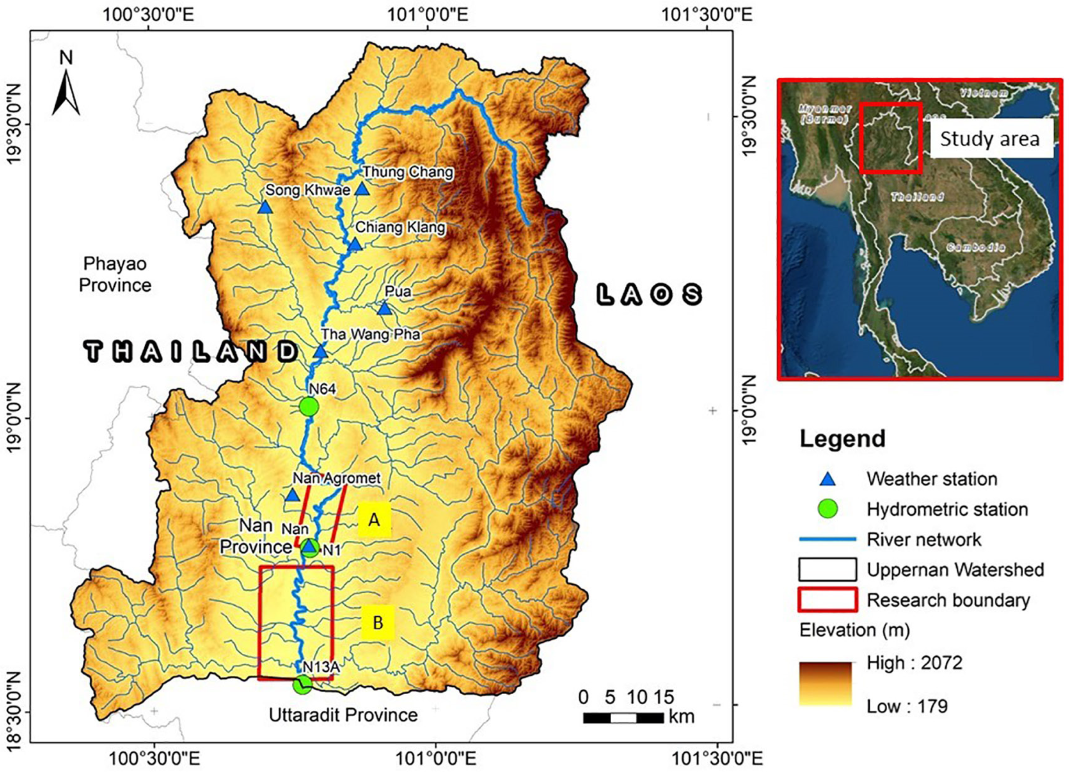
The lack of research that has been conducted on the Upper Nan Watershed is due to the characteristics of floods in this area being flash floods, which are harder to understand using regular flood modelling. Therefore, this study has aimed to fill this research gap to support our understanding of the future impact of climate change on flood hazards in the Upper Nan Watershed.
This study aimed to assess the variation of future rainfall, streamflow, and flooding, which will be driven by climate change. This assessment was conducted using three GCMs, under RCP4.5 and RCP8.5 scenarios, in the Upper Nan Watershed. As a part of the watershed management and mitigation efforts, the current study has enhanced our understanding of the future flood hazards that we can expect, particularly in the Upper Nan Watershed. This paper is organized as follows: The research background and the purpose of this study are discussed in
Section 1, and the data and methodology used in this study, including the SWAT model, the HEC-RAS model, and future climate change projection, are explained in
Section 2. Results and discussions are provided in
Section 3 and
Section 4, respectively, and the summary of this study is provided in
Section 5.
4. Discussion
4.1. Change in Rainfall Characteristics
This study showed that the future rainfall will be significantly different from the historic rainfall. In the future, we predict that the Upper Nan Watershed will be wetter and have a high rainfall fluctuation. An increase in the amount of rainfall has already occurred in Thailand, as we can see by comparing the rainfall in the historical period with the rainfall today. A study conducted by Thailand’s Meteorological Department mentioned that between 1980 and 2021, the rainfall nationwide in Thailand has shown an increasing trend in the northern part of Thailand, including in the study area.
The future rainfall in the Upper Nan Watershed, as predicted by the MPI-ESM-MR, under the scenarios RCP4.5 and RCP8.5, will continue to increase until the end of the 21st century. The results of this study were in line with previous studies, conducted by Komori et al. [
6] and Nontikansak et al. [
84]. Both of these previous studies revealed that, according to future climate predictions, extreme rainfall will occur more frequently and with more intensity in most areas of Thailand.
The increase in the amount and intensity of rainfall and extreme events (as defined by IPCC [
85]) will be a result of the increase in the global temperature, which is intensifying the global water cycle. Hotter air temperatures are accelerating evaporation in the water bodies, such as oceans and seas. However, the increase in surface temperature does not occur evenly in all locations, globally. Instead, surface temperatures are becoming hotter in some places and less hot in others. Under these conditions, the wind will become even stronger than it is at present, which will bring the water vapor from high-pressure areas to lower-pressure areas such as Southeast Asia. As predicted by IPCC [
85], Southeast Asia will be one of the regions in the world that experiences more precipitation in the future.
Furthermore, the region of Southeast Asia, including Thailand, is frequently affected by tropical cyclones in the South China Sea and the Andaman Sea. According to Vongvisessomjai [
86], Thailand is mostly affected by moderate north-westerly cyclone tracks in the rainy season. This phenomenon brings abundant water to Thailand and pours down in the Upper Nan Watershed, the first watershed in Thailand that faces the storm. Moreover, the orientation of this watershed is perpendicular to the tropical cyclone path, which leads to the occurrence of orographic rainfall by the watershed ridge. It is predicted that these tropical cyclones will intensify due to the increased temperature and air pressure differences worldwide, which will bring more rainfall to the Upper Nan Watershed.
4.2. Effect on Future Streamflow
This study discovered that the streamflow at both stations (N1 and N64) is not currently significantly different. However, the annual streamflow is predicted to increase in the future. Furthermore, the monthly streamflow peak is predicted to have a one-month lag, even if the future peak rainfall does not come one month later. Even if the rainfall, as the input of the study area, is significantly increased, it will not automatically lead to a significant rise in streamflow in the future.
Based on the principle of the hydrologic cycle in the watershed, some of the rainfall will be stored first in several places—such as the leaves of the plants; in the unsaturated zone, as soil moisture; and even stored further in the saturated zone, as groundwater. However, much of the excess rainfall water will flow from the watershed system as surface runoff. The lag time between the occurrence of the rainfall and the streamflow reaching the outlet of the watershed could explain the one-month lag in the predicted future streamflow peak.
The future rise in the streamflow that was predicted in this study was also confirmed by previous studies conducted in the same region. These were studies by Kure and Tebakari [
87], Tabucanon et al. [
30], and Hunukumbara and Tachikawa [
88]. Kure and Tebakari explained that, under scenario A1B of SRES, using MRI atmospheric general circulation models 3.1 and 3.2, the mean annual river discharge is expected to increase in the Chao Phraya River Basin. Furthermore, a study by Tabucanon et al. in Bhumibol Dam, Ping River, Northern Thailand, found that under EC-EARTH, the discharge inflow to the dam will experience enormous fluctuation, especially in the wet season. In another study by Hunukumbara and Tachikawa, it was discovered that the predicted discharge will increase both in the near future (2015–2039) and in the far future (2075–2099) in the north-central and the south-western parts of the Chao Phraya Watershed.
4.3. Effect on Future Flood Events
Both Muang Nan and Wiangsa are situated in the intermontane basin, a low-lying floodplain valley, surrounded by a mountainous area. A steep slope with high drainage density characteristics makes the study area prone to flash floods, since the streamflow rapidly accumulates downstream, in the lowest part of the watershed. Thus, the spatial flood pattern in this particular study area follows the low-lying, flat-sloped floodplain around the river. Muang Nan has more flat areas, which is why the extent of the floods in Muang Nan is larger than in Wiangsa.
It is still necessary to consider mitigation efforts before the actual floods occur in the far future, as part of the disaster risk reduction; however, we also need to be cautious and prepared in the medium future (2041–2060) for a flood in Muang Nan, under both RCP4.5 and RCP8.5. This flood is more likely to be of the same magnitude as that calculated for the 100-year flooding probability. The medium future flood of Wiangsa, under RCP4.5, is more likely to be of the same magnitude as that calculated for the 50-year flood probability, whereas the flood under RCP8.5 is likely to be of a similar magnitude to that calculated for the 100-year flood probability. Furthermore, the flooding of Muang Nan and Wiangsa, under both RCP4.5 and RCP8.5, in the near future (2025–2040), is predicted to be of a similar magnitude to the 50-year flood probability. Compared to the flood probabilities, the far future flood (2061–2080) is one that we should worry less about since the magnitude is only predicted to be similar to the 10–20-year flood probability.
Several of the areas that we predict will be inundated are considered vast, and possibly produce a huge amount of rice, which is a staple food for the local community and for neighboring countries. This study revealed that the three most impacted land uses in the study area will be rice fields, built-up areas, and intercrop trees. Of these three types of land use, the rice field will be the most largely impacted. In summation, in Muang Nan and Wiangsa, the area of rice fields that will potentially be impacted by the least frequent flood probability, at a return period of 100 years, could be as much as 28.5 km2. This number is 138.2% higher than the most common of the predicted flood probabilities (1-year flood).
The inundation of rice fields after a flood event in Thailand has been reported several times in previous studies. These reports are mostly from the 2011 flood since it was the worst flood that has been experienced in the modern period. Son et al. [
89] reported that, due to the 2011 flood in Thailand, 16.8% of the rice cultivation area in the Chao Phraya River Delta, which is dominated by land used for double-cropped rice, was inundated by flood water, causing damage to the rice. Similarly, Kotera et al. [
90], also reported on the same flood event, stating that at least 52.3% of the inundated area was categorized as damaged. Furthermore, Nara et al. [
91] mentioned that, due to the 2011 flood event, Thailand reported experiencing an economic slowdown because it had lost a considerable amount of rice, which is its major export commodity.
The great flood of 2011, in Thailand, caused a considerable amount of disruption. As it is, this flood will continue to be used as a reference point for the worst flood event in Thailand. Although we predict that floods will occur in the near future (2025–2040), we predict that the worst will occur in the middle future (2041–2060); therefore, we need to monitor the situation closely and prepare for it very well to reduce our potential losses in the future and avoid the considerable disruption that we experienced as a result of the 2011 flood.
5. Conclusions
The impacts of climate change in Thailand varied between the regions. The northern part of Thailand, represented by the Upper Nan Watershed, is predicted to be significantly impacted by climate change. Our study revealed that the rainfall in the Upper Nan Watershed, which has already shown an increasing trend, is predicted to increase further due to climate change. This will lead to a wetter Upper Nan Watershed in the future, both in the dry and wet seasons. Furthermore, increasing rainfall will change the characteristics of future discharge in the area. The change in the characteristics of the future discharge, such as the one-month delay in the timing of the discharge peak, the annual amount of the discharge peak increasing from 0.3% to 5.1%, and the discharge fluctuation. Moreover, this change in the discharge in the study area will increase the flooded area of land within the Upper Nan Watershed by between 12.5% and 37.3% in Muang Nan and between 2.7 and 10% in Wiangsa.
This study found that in the medium future (2041–2060), both Muang Nan and Wiangsa will potentially experience the magnitude of flooding associated with the 100-year flood probability. At the same time, we predict that the magnitude of flooding associated with the 50-year flood probability will also face these particular study areas in the near future (2025–2040). The rice field is the most common land use type in the area and, thus, will be the most impacted by these potential flood events. Therefore, it is essential that we closely monitor the situation and prepare well to reduce our potential losses in the future and avoid repeating the disruption that we experienced after the 2011 flood.
This study only focused on small and specific regions, so that the HEC-RAS model could focus more on the riverine flood modelling. However, floods that are caused by other phenomena, i.e., flash floods, were not covered. Furthermore, we did not discuss the best management practices (BMPs) for the watershed’s land use utilization and we did not consider the simulation of flood mitigation infrastructure (i.e., dikes, dams, gabions, and riparian zones) to reduce the impact of future floods. Therefore, we suggest that the next study should include a larger coverage area for the HEC-RAS model and that it should explore several BMPs and flood mitigation scenarios.


