Article

Spatial Water Consumption Test and Analysis of Various Typical Vegetation in the Sanjiangyuan Region

1
Qinghai Provincial Key Laboratory of Physical Geography and Environmental Processes, School of Geographical Sciences, Qinghai Normal University, Xining 810008, China
2
Key Laboratory of Water Cycle and Related Land Surface Processes, Institute of Geographic Sciences and Natural Resources Research, Chinese Academy of Sciences, Beijing 100101, China
3
State Key Laboratory of Plateau Ecology and Agriculture, Qinghai University, Xining 810016, China
*
Author to whom correspondence should be addressed.
Sustainability 2023, 15(6), 5422; https://doi.org/10.3390/su15065422
Submission received: 30 January 2023 / Revised: 8 March 2023 / Accepted: 15 March 2023 / Published: 18 March 2023
(This article belongs to the Special Issue Innovation and Technology for Sustainable Agriculture)

Abstract

:
Vegetation water consumption in the Sanjiangyuan Region is of direct significance to the utilization of local water resources. To measure the actual evapotranspiration of various typical vegetation with different vegetation types in the Sanjiangyuan Region, a Lysimeter was used between November 2019 and October 2020. Additionally, the Penman–Monteith equation was used to estimate the condensation water of different vegetation types. Based on the measured data, this paper analyzes the spatial distribution of annual water consumption and annual runoff of various vegetation types. Furthermore, the spatial and temporal distribution of monthly water consumption of vegetation types on different underlying surfaces are discussed. To establish the relationship between the precipitation and runoff of various vegetation types, an artificial rainfall test was conducted. This study’s results reveal several key findings: (1) Condensation water is widespread and can be observed throughout the year. The annual condensation water volume ranges between 28.47 and 56.88 mm, which is particularly significant for the growth of alpine desert steppe and alpine steppe vegetation. (2) The annual water consumption in the Sanjiangyuan Region was higher in the south than in the north. Shrub water consumption was found to be 58.1–73.3 mm higher than that of grasses. Water consumption primarily occurred during the growing season, spanning from May to October. (3) The total water consumption in the growing season of the alpine meadow was less affected by precipitation compared to the non-growing season (from November to the next April). (4) The runoff yield can be ignored in the non-growing season when calculating water balance. However, during the growing season, the calculation of runoff cannot be ignored due to its significant impact on vegetation water consumption.

1. Introduction

Evapotranspiration, which is the sum of soil evaporation and vegetation transpiration, is a crucial process in the dissipation of surface water resources. Between 70% and 90% of surface precipitation returns to the atmosphere through evapotranspiration [1]. The bulk of evapotranspiration is driven by vegetation water consumption, which exerts a non-negligible influence on the water and heat balance process and water cycle of the ecosystem [2]. As such, evapotranspiration represents an essential component in the calculation of water balance in a basin, and it is also the primary hydrological characteristic parameter, playing a crucial role in the rational development and utilization of water resources.
Many equations and algorithms have been developed to estimate evapotranspiration, such as the SEBAL (Surface Energy Balance Algorithm for Land) model, the Penman–Monteith model, and the Hargreaves model among others. These methods have been widely used to estimate vegetation and crop evapotranspiration in different parts of the world [3,4,5,6]. In recent decades, remote sensing technology has played a significant role in revealing the spatial distribution of surface evapotranspiration over large areas, leveraging its unique advantages in studying evapotranspiration [7]. However, remote sensing models rely heavily on surface meteorological and hydrological data, requiring high-quality data for accurate estimation. Additionally, most remote sensing models face challenges in universal applicability in different study areas due to underlying surface conditions and regional limitations. As a result, measured evapotranspiration data is necessary to improve the accuracy of the evapotranspiration model and to verify the model’s output [8].
Various methods are used to measure actual evapotranspiration, including the eddy covariance method [9,10], the Lysimeter method [11], the Sap-Flow method [12,13], the water balance method [14,15], etc. The eddy covariance method requires a smooth and uniform underlying surface, and it assumes that the system does not gain or lose mass during calculation. The Lysimeter method is regarded as the most accurate direct measurement method for evapotranspiration measurement [16]. It works by computing the water budget through measuring the weight change and runoff of the soil column in the lysimeter. However, due to its high cost and management complexity, the Lysimeter method is primarily used in crop observation and is rarely employed in natural ecosystem research [17].
Currently, numerous studies focus on estimating the evapotranspiration of the Sanjiangyuan Region. Notably, large-scale models such as FAO56 P-M [18] and the surface energy balance model [19] have been utilized for this purpose. However, when these models need their accuracy verified with actual evapotranspiration, the potential evapotranspiration estimated based on meteorological data is usually used instead of actual evapotranspiration data, which is often lacking in the study area. Due to varying vegetation conditions and soil moisture limitations in the Sanjiangyuan Region, there is a significant difference between actual evapotranspiration and potential evapotranspiration, resulting in deviations between model estimates and actual evapotranspiration. Some studies have used eddy data to verify model accuracy, but the evapotranspiration results were underestimated due to the eddy correlation data’s failure to close [20]. Several studies have focused solely on evapotranspiration during the growing season, disregarding the importance of non-growing-season evapotranspiration [21]. However, the experimental sites in these studies have been relatively homogeneous. Given the complex topography, extensive regional coverage, and significant underlying surface heterogeneity in the Sanjiangyuan Region, a single experimental site may not fully capture the water consumption patterns of an ecosystem with multiple underlying surfaces or accurately describe the evapotranspiration of the entire region. Furthermore, the region’s harsh natural environment makes it more challenging to observe the water consumption patterns of multiple vegetation types. Currently, there is a paucity of observational data on the actual evapotranspiration of different natural vegetation types across multiple observation stations in the region. Additionally, existing studies have largely disregarded condensation, despite its importance as a source of evapotranspiration, particularly in arid areas [22]. Furthermore, most studies on actual evapotranspiration in the Sanjiangyuan Region have failed to observe runoff: an essential component of the water balance formula that significantly impacts the final calculation of evapotranspiration. Thus, runoff observation is critical for accurately determining the actual evapotranspiration in the region.
In recent decades, the Sanjiangyuan Region has experienced a significant shift in its climate, characterized by rising temperatures [23], decreasing precipitation [24], and intensifying evaporation [25]. This shift, coupled with the reduction of biodiversity and destruction of vegetation [26] in wetland ecosystems, poses a significant threat to the region’s ecological security and water conservation capacity. Therefore, conducting an in-depth analysis of the spatial water consumption of different vegetation in the Sanjiangyuan Region is of critical importance to accurately understand the current state of the region’s water resources. This study utilized the Lysimeter method to conduct a long-term field test in the cold alpine regions, observing the actual evapotranspiration and runoff yield of different vegetation and analyzing the temporal and spatial distribution of evapotranspiration. Additionally, the relationship between precipitation and surface runoff of various vegetation types was examined through an artificial precipitation test. The findings of this research offer essential data for the study of vegetation evapotranspiration in the Sanjiangyuan Region and can serve as a reference for calculating water consumption of vegetation on a large spatial and temporal scale.

2. Materials and Methods

2.1. Overview of the Study Area

The Sanjiangyuan Region, situated in the heart of the Qinghai–Tibet Plateau, is the source of three major rivers: the Yangtze, Yellow, and the Lancang. The region’s ecosystem boasts significant water conservation capacity [27,28], and its distinct alpine vegetation system plays a crucial role in global climate change and climate response research [29]. The Sanjiangyuan Region is located between 31°39′~37°10′ N, and 89°24′~102°27′ E, covering a total area of 395,000 km2 at an average altitude of 4200 m. The region has a typical plateau continental climate, with little seasonal variation, regularly alternating between low and high temperatures, distinct dry and wet seasons, the simultaneous presence of rain and heat, and long hours of sunshine. The plant growth period is short due to the harsh climate, with an average annual temperature of −5.6~7.8 °C, an annual precipitation of 262.2~772.8 mm, an annual sunshine duration of 2300~2900 h, and annual solar radiation of 5658~6469 MJ/m2. The oxygen content in the air is only around 60~70% of that at sea level.
The Sanjiangyuan Region comprises nine vegetation types, including coniferous forest, broad-leaved forest, coniferous and broad-leaved mixed forest, alpine shrub, alpine meadow, alpine grassland, alpine swamp and alpine aquatic vegetation, alpine cushion vegetation, and alpine sparse vegetation. The main species of shrub vegetation in this region are Rhododendron, Salix, Hippophae, Potentilla fruticose, Caragana, Spiraea, Xunzi, and so on. The main plant species of grassland and meadow are Artemisia, Stipa Stipa, Carex, Saussurea, Roegneria, Poa pratensis, Elymus, Achnatherum, algae, moss, and so on. Alpine meadow and alpine grassland are the main types of vegetation and natural grasslands of the Sanjiangyuan Region. As shown in Figure 1, the region has diverse vegetation, which is widely distributed.

2.2. Test Plan

2.2.1. Equipment and Principle of Lysimeter

A Lysimeter is an observation device used to measure vegetation water consumption. It operates based on the principle of water balance by measuring changes in bucket weight, underground leakage, and surface runoff. It is widely recognized as the most accurate instrument for observing the water consumption of vegetation [30]. To suit the biological characteristics of shrubs, forages, and typical communities, different types of Lysimeters were designed and manufactured. These include a plant evapotranspiration observation device (ZL201921146973.0) and a small soil evapotranspiration automatic monitoring device (ZL201921146987.2). The Lysimeter was backfilled with soil, and a piece of turf was placed on top. Catheters and water storage bottles were installed at the bottom to collect runoff (see Figure 2). The small Lysimeter had a measuring bucket with a diameter of 200 mm and a height of 500 mm and it was weighed by an LT30KA-1 electronic balance with an accuracy of 0.1 g, converted to a water depth of 0.003 mm. The medium-sized Lysimeter had a measuring bucket with a diameter of 500 mm and a height of 500 mm, and it was weighed by an LT150K balance with an accuracy of 1 g (converted to a water depth of 0.005 mm). Both types of electronic balances were produced by Changshu Tianliang Instrument Co., Ltd. (Changshu, China). The water balance equation is as follows:
E T = I + P + D + Δ W Q + R ,
where ET is the evapotranspiration; I is the irrigation amount (no water supply in this test, and so I = 0); P is the amount of rainfall; D is the amount of condensation water; Δ W is the variation of soil water content in the Lysimeter; Q is the amount of soil water leakage; and R is the surface runoff. In this test, the surface runoff and soil water leakage, that is, the sum of Q and R (hereinafter referred to as runoff production), were collected using water storage bottles. The Lysimeter bucket did not come into contact with the surrounding soil, and there was no groundwater supply to the Lysimeter bucket. The influence of groundwater on evapotranspiration was not considered in this test.
Many studies have shown that water condensation occurs overnight [31], and vegetation transpiration and soil evaporation occur throughout the day [32]. During the day, evaporation is dominant and condensation is negligible, while at night, evaporation is weak and condensation is more prominent than evaporation. In order to facilitate the observation and calculation of condensation water, evaporation is assumed to stop if Δ W is positive during the intraday evapotranspiration observation. Let ET = 0, and then the equation is as follows:
D = Δ W + Q + R I P   .

2.2.2. The Layout of the Evapotranspiration Field

To accurately represent the spatial distribution of vegetation water consumption in the Sanjiangyuan Region, we selected 6 evapotranspiration fields near the weather stations that represent typical alpine desert grasslands, alpine grasslands, alpine meadows, and alpine shrubs, respectively. The evapotranspiration fields were established on a flat underlying surface. To capture the diversity of vegetation in the region, we selected 22 vegetation species from dominant species, constructive species, and typical communities surrounding the evapotranspiration fields for observation (see Table 1 and Table 2). The evapotranspiration fields were located in Maixiu: a town in Zeku County, Dengta: a town in Banma County, Dawu: a town in Maqin County, the Longbaotan Wetland Reserve of Yushu City, Ziketan: a town in Xinghai County, and the Tiegai Township in Gonghe County (see Figure 3). Specifically, the evapotranspiration fields in Zeku County and Banma County were for observing the water consumption of shrubs such as Potentilla fruticose, Berberis dubia, Caragana jubata, and Salix cheilophila var. cheilophila; the evapotranspiration fields in Maqin County and Yushu City were for forage and included Puccinellia tenuiflora, Stipa capillata, Poa annua var. annua, Elymus nutans, Achnatherum splendens, Agropyron cristatum (Linn.) Gaertn. var. cristatum, Carex caespititia, and Kobresia pygmaea; and typical communities (bare ground, Achnatherum splendens community, Agropyron cristatum (Linn.) Gaertn. var. cristatum community, Elymus nutans community, Kobresia pygmaea community, Potentilla fruticosa community, and weed community) were observed in the evapotranspiration fields in Xinghai, Gonghe, and Yushu. Small-sized Lysimeters were used on forage, and medium-sized Lysimeters were used on shrubs and typical communities, respectively.
The Lysimeters were installed between June and August of 2019, and the restoration of soil and vegetation took place from September to October 2019 (see Figure 3).

2.2.3. Items and Frequency of Observation

See Table 2 for the number of duplicates of Lysimeters for observing vegetation in different evapotranspiration fields. A rainfall cylinder (David, USA) and a portable weather station (David, USA) were arranged in each evapotranspiration field, and the precipitation, temperature, dew point temperature, air humidity and wind speed were recorded once per hour.
During the experimental period of November 2019 to October 2020, we measured actual evapotranspiration and runoff yield using Lysimeters and water storage bottles. We weighed these instruments every 5 days during the growing season (May–October), and every 15 days during the non-growing season (November–April) of the following year).
Regarding condensation water observation, observation of condensation water was carried out on typical sunny days with the Lysimeters in 2021 in Maqin (May 12~May 14), Zeku (May 24~May 27), Banma (June 9~June 10), and Yushu (June 14~June 16). The weight was measured every 2 h from 5:00 to 21:00.

2.2.4. Artificial Precipitation Simulation Test

In order to study the runoff yield of various vegetation types in the Sanjiangyuan Region, gradient precipitation was simulated with sprinklers on certain typical sunny days, and the surface runoff and soil water leakage were collected separately. The test ended as soon as the surface runoff was generated, and the surface runoff and soil water leakage were weighed, respectively. The precipitation gradients of each evapotranspiration field site were as follows:
1. There were six treatments and two replicates in each group of forage in Maqin. One treatment was the control without an artificial precipitation test and the other five treatments showed precipitation measurements with increasing gradients of 4 mm starting at 4 mm. There were five gradients in total;
2. There were six treatments and two replicates in each group of forage in Yushu. One treatment was the control without an artificial precipitation test and the other five treatments showed precipitation measurements with increasing gradients of 4 mm starting at 4 mm. There were five gradients in total;
3. The typical community of Yushu had 3 treatments and 1 replicate in each group. One treatment was the control without artificial precipitation and the other two treatments, starting at 15 mm, showed precipitation measurements with increasing gradients of 5 mm. Two artificial precipitation tests were carried out, with the treatments of the first tests showing 15 mm and 20 mm of precipitation, respectively. If no surface runoff was produced, the second artificial precipitation test would be carried out immediately, with both treatments showing 10 mm of precipitation.
4. Each group of shrubs in Zeku was tested with 6 treatments and 2 replicates. One treatment was the control without an artificial precipitation test and the other five treatments started at 10 mm of precipitation with increasing gradients of 4 mm. There were five gradients in total.
5. Each group of shrubs in Banma had 4 treatments and 2 replicates. One treatment was the control without an artificial precipitation test and the other three treatments, started at 20 mm of precipitation with increasing gradients of 5 mm. There were 3 gradients in total.

2.2.5. Data Source and Processing

This study obtained the Lysimeter data and meteorological data of the evapotranspiration fields and analyzed the hourly data of the weather stations near the evapotranspiration fields provided by the Qinghai Meteorological Bureau, which included precipitation, maximum temperature, minimum temperature, average temperature, dew point temperature, air humidity, atmospheric pressure, and wind speed at 2 m height. The meteorological data of the evapotranspiration fields were used to examine and calibrate those of the Qinghai Meteorological Bureau. For the data of the evapotranspiration fields far away from the national standard meteorological stations and the data missing in the test, the remote sensing interpolation method was applied. For abnormal data of Lysimeters, the following processes were performed, respectively: (1) For weighing errors caused by the electronic balance, all data from the test were eliminated, and the water balance was calculated with the previous and the next set of observation data. (2) We discriminated the abnormal values using the 3δ criterion for repeated test data in each group and eliminated the data that failed the test. (3) We ran single-sample T-tests on the data that passed the 3δ criterion test and eliminated the data that failed the test.

2.3. Estimating Condensation Water Using the Penman–Monteith Formula

As the duration for actual condensation water observation in the test was finite, in order to obtain the condensation water data of the whole test period, the empirical formula parameters were calibrated with existing observation data. The hourly condensation water was estimated according to the Penman–Monteith formula [33], and the daily and monthly condensation water was obtained by summing the hourly condensate. The formula is as follows:
E T 0 = 0.408 Δ R n G + γ C n T + 273 μ 2 e s e a Δ + γ 1 + C d μ 2   ,
where, if ET0 > 0, ET0 is the reference evaporation of vegetation (mm/hour); if ET0 < 0, the absolute value of ET0 is the condensation water amount [34]; Rn is the net solar radiation (MJ/m2·hour) (calculated according to Angstrom’s solar empirical formula, which will not be described in detail in this paper); G is the soil heat flux (MJ/m2·hour), and G = 0 at night; Δ is the slope of saturated water pressure (kPa/°C); T is the average temperature (°C); μ 2 is the wind speed (m/s) at the height of 2 m; Cn is the molecular constant regarding reference vegetation type and time step; Cd is the denominator constant regarding vegetation type and time step; γ is the hygrometer constant (kPa/°C); es is the saturated vapor pressure; and ea is the actual water pressure (kPa).

3. Results and Analysis

The monthly water consumption results of the Lysimeters in different evapotranspiration fields were inspected with a single-sample T-test, and the data that failed the test (p > 0.01) or had no statistical significance were eliminated. A total of 95% of the data passed the single-sample T-test.

3.1. Analysis of Condensation Water of Different Vegetation

During the typical sunny days in May and June, the condensation water was observed as early as 18:00 on the previous day to as late as 10:00 on the following day. The amount of condensation water reached its maximum between 7:00 and 8:00 on the following day, and then gradually decreased to zero. The daily condensation water observed in this test was 0.01–0.67 mm.
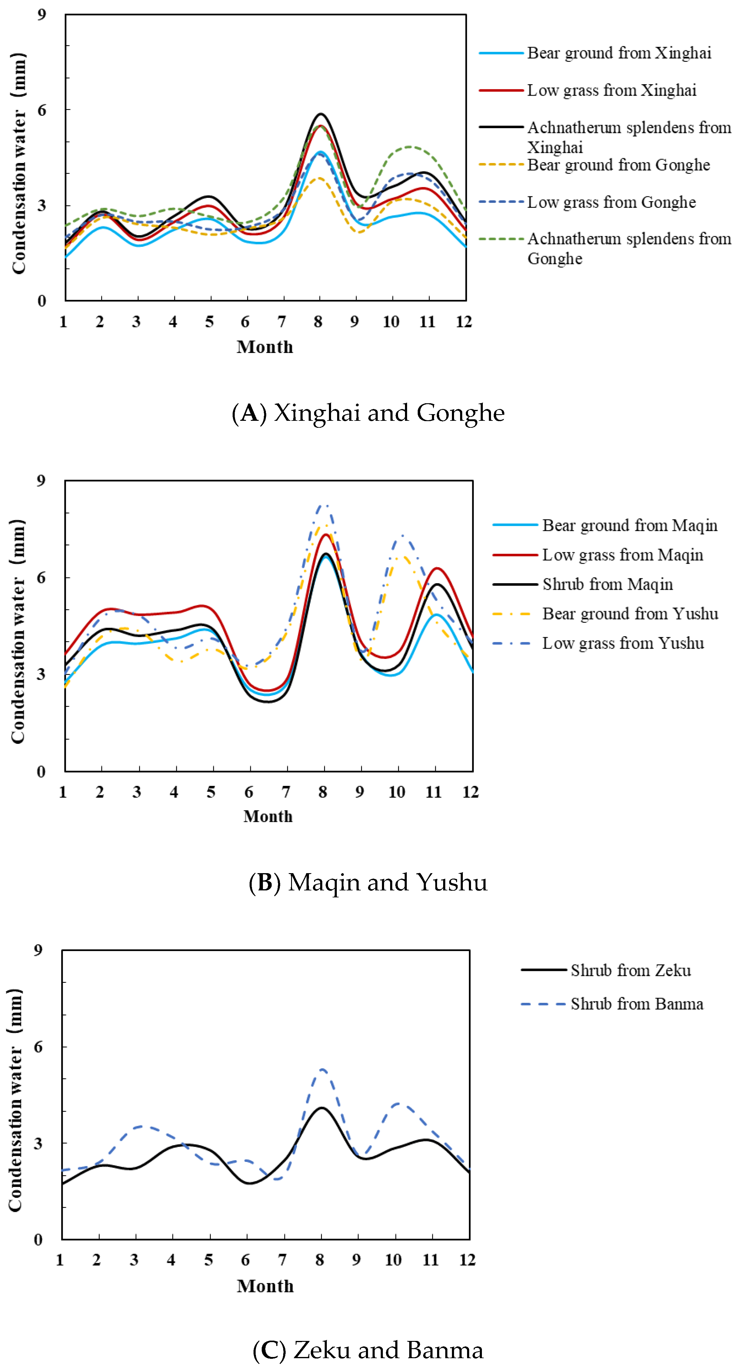
The Cn and Cd of different vegetation were set according to the vegetation type and time step, and the Penman–Monteith formula was used to estimate the daily condensation water of different vegetation types in different evapotranspiration fields. There was a strong correlation between daily observed condensation water and estimated condensation water. The Pearson correlation coefficient was 0.80 (p < 0.01), RMSE was 0.10, and MAE was 0.08 mm; all were within the acceptable range. The estimated condensation water range was 0–0.59 mm. Table 3 shows that the annual condensation water ranged from 28.47 to 56.88 mm, accounting for 5.98~10.84% of the annual precipitation. The percentage of annual condensation water to annual precipitation was in the order of Gonghe > Xinghai > Yushu > Maqin > Zeku > Banma. The variation trend of condensation water, the range of daily condensation water, and the annual amount of condensation water were consistent with the research results of the Fenghuoshan Basin [35], Heihe Basin [36], and Shazhuyu alpine sandy areas [37].
The amount of condensation water during the year showed a bimodal trend (see Figure 4), with the lowest amounts in winter and spring, the largest in late summer and early autumn (August), and the second-largest in late autumn and early winter (October and November).

3.2. Analysis of Water Consumption of Forage

The annual precipitation in Maqin was 639.9 mm, and the annual water consumption was 478. 7~519.6 mm with an average of 499.9 mm for Puccinellia tenuiflora, 515.6~564.6 mm with an average of 553.6 mm for Poa annua var. annua, 451.3~558.8 mm with an average of 533.6 mm for Elymus nutans, and 494.0~563.8 mm with an average of 542.4 mm for Stipa capillata (see Table 4 and Table 5). The annual precipitation in Yushu was 596.3 mm, and the annual water consumption was 542.9~657.5 mm with an average of 593.0 mm for Carex caespititia and 544.8~609.3 mm with an average of 581.5 mm for Kobresia pygmaea. The annual water consumption of the forage in Yushu was higher than that in Maqin, and the order of water consumption was: Carex caespititia > Kobresia pygmaea > Poa annua var. annua > Stipa capillata > Elymus nutans > Puccinellia tenuiflora (see Figure 5).
The water consumption values of the four forages in Maqin were basically the same. As temperature increased in April, the vegetation resuscitated and the water consumption began to rise, reaching its maximum in July. Then, the plant physiological activities gradually slowed down, and the water consumption gradually decreased until the vegetation died away in November and entered the dormant period. The water consumption values of the two kinds of forage in Yushu corresponded to that in Maqin, where the water consumption began to rise in March, reached the maximum in September, and then gradually decreased. The water consumption of the growing season (May-October) of forage in Maqin accounted for 86.82~89.72% of the annual water consumption, and the water consumption in Yushu accounted for 77.21~78.46%.

3.3. Analysis of Water Consumption of Shrubs

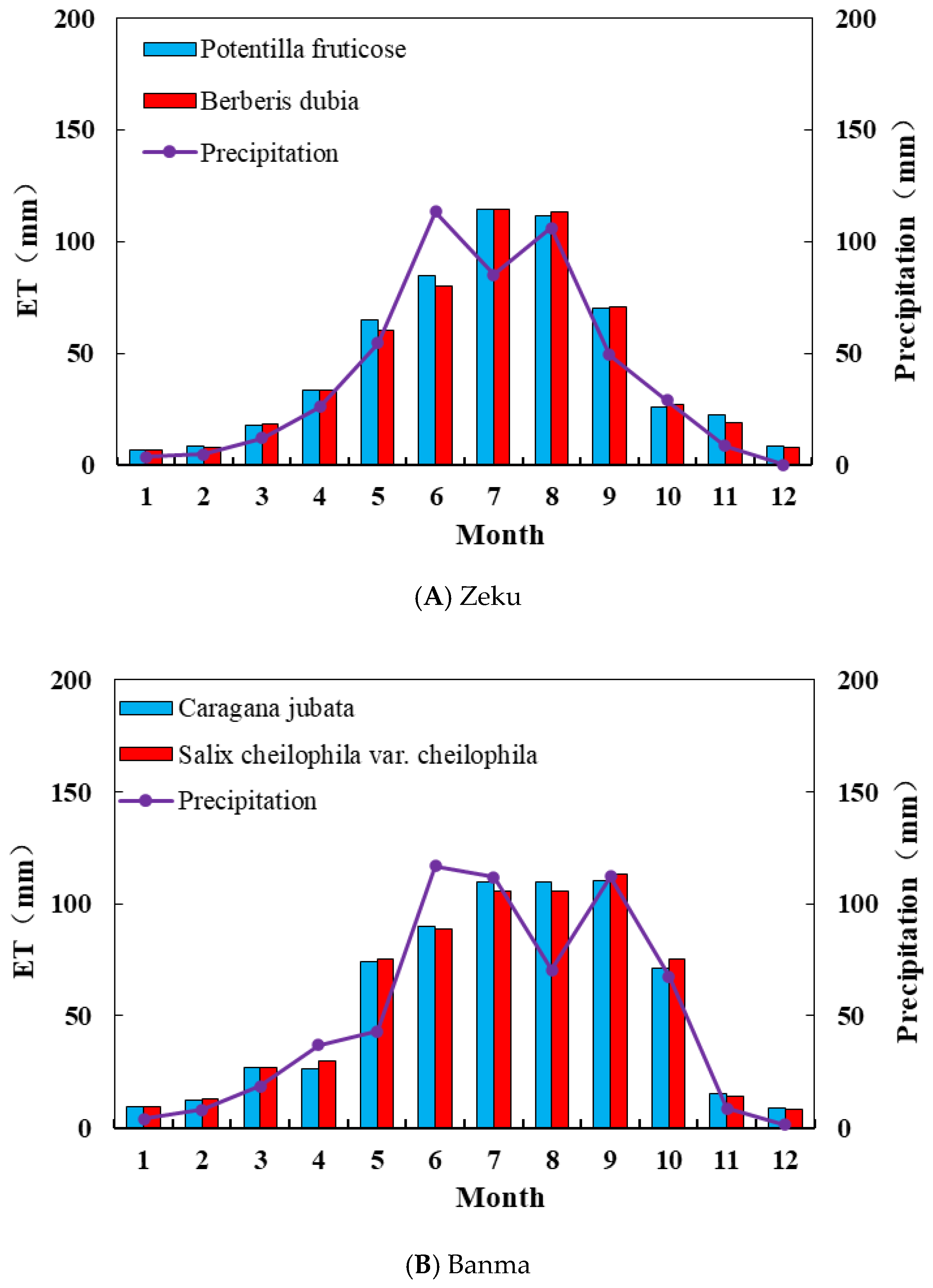
The annual precipitation in Zeku was 492.3 mm, and the annual water consumption was 541.4~593.0 mm with an average of 567.30 mm for Potentilla fruticose and 541.0~579.5 mm with an average of 558.0 mm for Berberis dubia. The annual precipitation in Banma was 599.3 mm, and the annual water consumption was 575.0~712. 9 mm with an average of 663.9 mm for Caragana jubata and 545.7~762.7 mm with an average of 666.3 mm for Salix cheilophila var. cheilophila. The annual water consumption of shrubs in Banma was greater than that in Zeku, and the order of water consumption was: Potentilla fruticose > Salix cheilophila var. cheilophila > Caragana jubata.
The changing processes of monthly water consumption of the four shrubs in Zeku and Banma, shown in Figure 6, resembled each other. The water consumption began to increase in April, reached its maximum in July, and gradually decreased until the vegetation died away in November and entered the dormant period, when the water consumption became smaller. The water consumption of shrubs in the growing season accounted for 82.96~83.41% of the annual water consumption in Zeku and 84.63~85.08% in Banma.

3.4. Analysis of Water Consumption of Typical Communities

In Maqin’s typical community observation, because the equipment was damaged during the observation, only three sets of valid data were obtained in November and December 2019, and October 2020. According to the abnormal data processing method of Lysimeter (1), the sum of the monthly water consumption of typical communities from November 2019 to October 2020 was calculated.
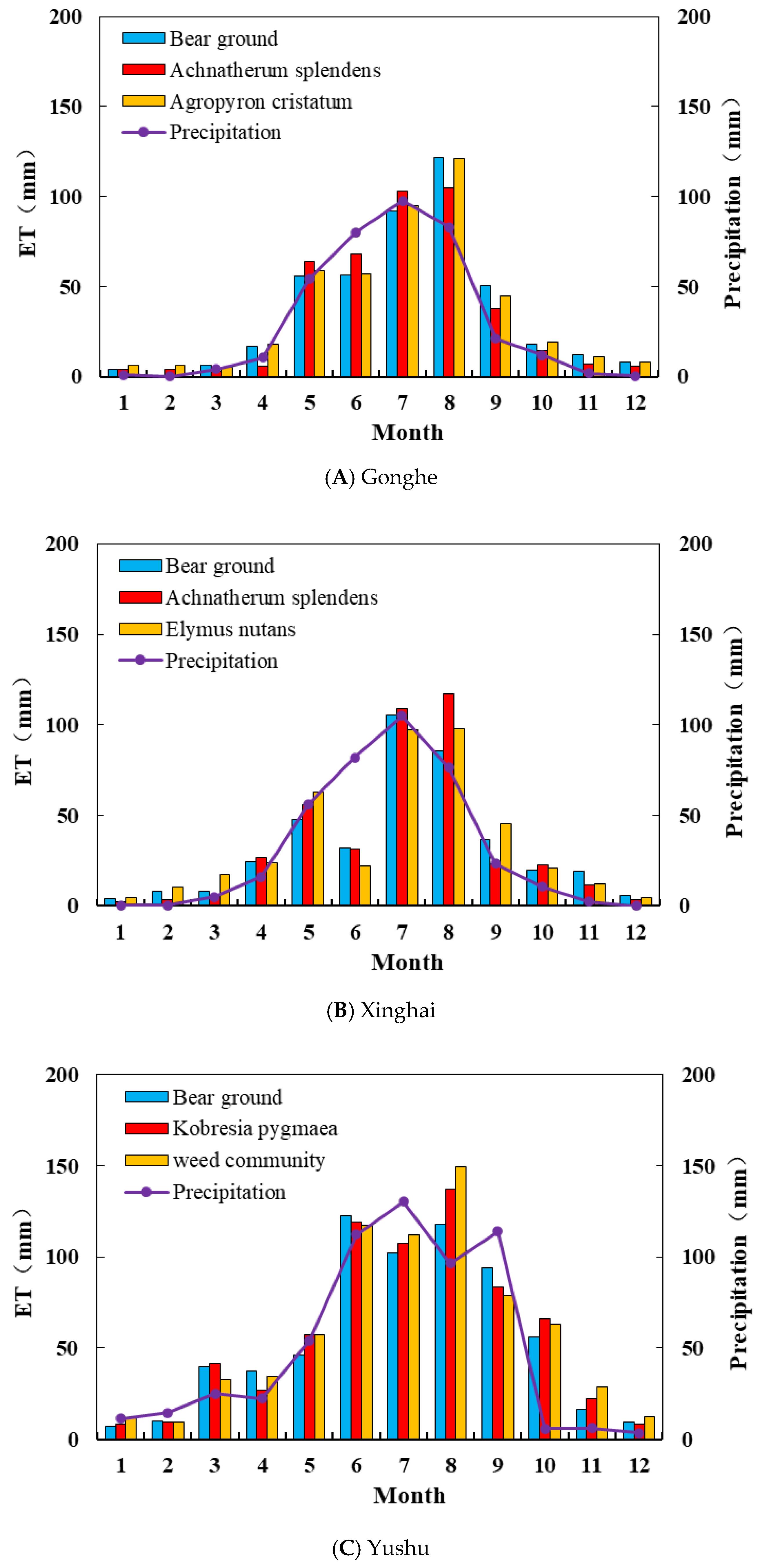
The underlying surfaces of Gonghe and Xinghai were alpine desert grassland and alpine grassland with sparse vegetation and much bare ground. The annual precipitation in Gonghe was 367.08 mm, and the annual water consumption was 437.4~450.3 mm with an average of 443.6 mm for bare ground, 402.2~431.3 mm with an average of 423.0 mm for the Achnatherum splendens community, and 438.8~456.4 mm with an average of 452.3 mm for the Agropyron cristatum (Linn.) Gaertn. var. cristatum community. The annual precipitation in Xinghai was 377.6 mm, and the annual water consumption was 370.13~401.26 mm with an average of 396.20 mm for bare ground, 396.7~414.5 mm with an average of 412.6 mm for the Achnatherum splendens community, and 411.8~424.5 mm with an average of 419.5 mm for the Elymus nutans community. The annual water consumption of the Achnatherum splendens community was less than that of the Elymus nutans community. The vegetation water consumption began to increase in April and May, and the vegetation water consumption in June decreased or remained the same as that in May. The bare ground and Elymus nutans communities in Xinghai reached the maximum in July and then decreased. While the Achnatherum splendens communities in Xinghai and the bare ground, as well as the Achnatherum splendens communities and the Agropyron cristatum (Linn.) Gaertn. Var. cristatum communities in Gonghe, reached the maximum in August and then decreased (see Figure 7). The water consumption of the growing season of typical communities in Gonghe accounted for 87.60~92.91% of the annual water consumption, and in Xinghai, it accounted for 82.43~87.12%.
The underlying surfaces of Maqin and Yushu were alpine meadow. The annual water consumption in Maqin was 657.9~697.8 mm with an average of 683.4 mm for bare ground, 685.6~699.0 mm with an average of 694.2 mm for the Kobresia community, and 685.2~705.2 mm with an average of 692.6 mm for Potentilla fruticose. The annual water consumption in Yushu was 648.1~670.5 mm with an average of 659.3 mm for bare ground, 669.9~706. 6mm with an average of 687.3 mm for the Kobresia community, and 701.7~746.6 mm with an average of 707.7 mm for the weed community.
The monthly water consumption of typical communities in Yushu began to rise in April, reached the first peak in June, decreased in July, and reached the maximum value of the year in August, and then decreased sharply and tended to stabilize in November. The water consumption of typical communities during the growing season in Yushu accounted for 81.71~83.00% of the annual water consumption.

3.5. Analysis of Annual Runoff Yield

The annual runoff yields of forage in Maqin of Puccinellia tenuiflora, Poa annua var. annua, Elymus nutans, and Stipa capillata were 114.75 mm, 94.2 mm, 107.37 mm, and 104.85 mm, respectively, accounting for 18%, 15%, 17%, and 16% of the annual precipitation, respectively. In Yushu, the annual runoff yield of forage of Carex caespititia and Kobresia pygmaea were 99.73 mm and 115.83 mm, respectively, accounting for 17% and 19% of the annual precipitation, respectively.
The annual runoff yields of shrubs in Zeku of Potentilla fruticose and Berberis dubia were 0.81 mm and 0.36 mm, respectively, which was too small and thus ignored during data analysis. In Banma, the annual runoff yields of shrubs of Caragana jubata and Salix cheilophila var. cheilophila were 26.17 mm and 23.34 mm, respectively, accounting for 4% and 4% of the annual precipitation, respectively.
The annual runoff yield in Gonghe of the Agropyron cristatum (Linn.) Gaertn. var. cristatum community was only 0.3 mm and thus ignored during data analysis. In Xinghai, the annual runoff yields of the typical community of bare ground, the Achnatherum splendens community, and the weed community were 45.26 mm, 70.39 mm, and 51.13 mm, respectively, accounting for 12%, 16%, and 14%, of the annual precipitation, respectively. In Yushu, the annual runoff yield of the typical community of bare ground, the Kobresia community, and the weed community was 31.54 mm, 10.35 mm, and 9.25 mm, respectively, accounting for 5%, 2%, and 2% of the annual precipitation, respectively.

3.6. Relationship between Surface Runoff and Artificial Precipitation

When precipitation occurred, the generation of surface runoff was related to vegetation height and vegetation coverage. It can be seen in Table 5 that at the initial stage of vegetation growth, except for bare ground, the vegetation coverage of the turf inside the Lysimeter was up to 72.81~98.13%, the height of forage was 2.5~11.88 cm, and the height of shrubs was 30.00~63.91 cm.
In Maqin, with precipitation gradients of 10 mm, Elymus nutans collected a total of 4.9 mm of surface runoff, without soil water leakage. When the precipitation reached 11.57 mm, Stipa capillata began to produce surface runoff of 1.81 mm with 1.81 mm of soil water leakage. When the precipitation reached 8.19 mm, Poa annua var. annua began to produce surface runoff with a total of 2.8 mm and 0.04 mm of soil water leakage. When the precipitation reached 16 mm, Puccinellia tenuiflora did not produce surface runoff. When the precipitation reached 10 mm, there was no surface runoff of bare ground, the Kobresia community, or the Potentilla fruticose community.
In Yushu, when the artificial precipitation reached 23.26 mm, the bare ground began to produce surface runoff totaling 0.47 mm and 1.73 mm of soil water leakage. When the precipitation reached 30 mm, neither the Kobresia community nor the weed community produced surface runoff. When the precipitation reached 35 mm, there was no surface runoff of the two forages Carex caespititia or Kobresia pygmaea. In Zeku and Banma, when the artificial precipitation reached 35 mm and 30 mm, respectively, the shrubs did not produce surface runoff.

4. Discussion

The annual amount of condensation water on bare ground was found to be lower than that on vegetated ground in Gonghe, Xinghai, Maqin, and Yushu. The annual amount of condensation water on shrubs was found to be between that on bare ground and low grass in Maqin. These findings are consistent with the conclusions of previous experimental studies conducted by Wang Zhongjing [36] and Liu Xin [35]. Vegetation with a large leaf area has more contact with the atmosphere, which makes it possible to generate more condensation water. Higher vegetation is generally more conducive to the generation of condensation water [38]. however, if the density of the vegetation is too high, the surface temperature can decrease, which can result in a decrease in the amount of condensation water [39]. These findings suggest that condensation water is an important supplementary source to vegetation water consumption in the Sanjiangyuan Region, particularly for local ecology with less precipitation. However, in the actual observation process, condensation and vegetation transpiration, as well as soil evaporation, occurred alternately. This test assumed that the evapotranspiration at night was zero and the transpiration and evaporation were not distinguished during nightly observation, which may cause an underestimation of condensation water.
During the observation period, although Maqin received more precipitation than Yushu, the annual water consumption of forage in Yushu was higher than that in Maqin, which is consistent with the findings of Xiuying Wang et al. [39]. In the growing season, the water consumption of forage in Yushu and Maqin was relatively close. However, in the non-growing season, the higher precipitation in Yushu resulted in nearly double the water consumption of forage compared to Maqin, leading to a higher annual water consumption in Yushu forage. Additionally, the non-growing season water consumption of shrubs in Zeku and Banma was similar, resulting in a relatively similar annual water consumption percentage for both locations. These findings suggest that the total water consumption of alpine meadows in Yushu and Maqin is less affected by precipitation compared to the non-growing season. During the observation process of typical communities in Maqin, most of the annual runoff data were not observed and recorded in time, and the actual recorded annual runoff was less. The water balance principle was used to include unrecorded runoff as vegetation water consumption, leading to larger water consumption of typical communities than for forage. The water consumption of Yushu forage is lower than that of typical communities due to the smaller barrel diameter of the evapotranspiration meter used for forage compared to shrubs. The observations from smaller evapotranspiration meters tend to be lower than those from larger ones [40], resulting in an overestimation of the difference in annual water consumption between forage and shrubs.
During the observation of vegetation water consumption throughout the year, the ratio of runoff to annual precipitation was found to be high, reaching up to 19%. The order of vegetation runoff was: bare land > grass > shrub. In the artificial precipitation tests, the precipitation thresholds of surface runoff generated by different vegetation types were different due to their underlying surfaces. Overall, the performance order of bare land > grass > shrub was observed. Vegetation surface runoff is an integral part of runoff generation. In the source area of the Sanjiangyuan Region, there is very little surface runoff when precipitation is low. However, when short-term heavy precipitation occurs, the lower the surface vegetation coverage, the more prone it is to surface runoff [26]. Bare land, due to the scarcity of surface vegetation, is not able to intercept and store water, and it is more likely to produce surface runoff [41]. Therefore, while the principle of water balance allows for the ignoring of runoff during the non-growing season due to low precipitation and no short-term heavy precipitation, in the growing season, especially in July and August when there are more short-term heavy rainfall events, the calculation of runoff generation cannot be ignored.

5. Conclusions

The water consumption of various vegetation types in the Sanjiangyuan Region was analyzed through Lysimeter tests from November 2019 to October 2020. The spatial distribution of annual water consumption of vegetation in the study area was generally high in the south and low in the north. The annual water consumption of shrubs was found to be 58.1~73.3 mm higher than that of grasses. However, due to the different sizes of Lysimeters for grasses and shrubs, the difference between the two may have been overestimated. The main water consumption occurred during the growing season (May–October), accounting for 77.21–92.91% of the annual water consumption. Condensation water was found to be an important water supplement for vegetation water consumption in the Sanjiangyuan Region, but it was underestimated. It is particularly significant for the growth in alpine desert steppe and alpine steppe regions, which have less annual precipitation. The total water consumption of alpine meadows during the non-growing season was more affected by precipitation than during the growing season. Runoff yield is an important element in the water balance equation, and as ground vegetation coverage increases, the runoff yield gradually decreases. While the non-growing season vegetation runoff yield can be ignored in the water balance equation, the growing season runoff yield has a significant impact on vegetation water consumption, and, therefore, the runoff yield calculation cannot be ignored.
One year of data is not sufficient to represent the characteristics of spatial evapotranspiration over many years in the Sanjiangyuan Region. It is necessary to observe the spatial evapotranspiration for a longer time series to gain a better understanding of its characteristics.

Author Contributions

Conceptualization, S.J. and R.L.; methodology, L.Q. and S.J.; software, L.Q.; validation, L.Q. and S.J.; formal analysis, L.Q.; investigation, L.Q.; resources, R.L.; data curation, L.Q. and R.L.; writing—original draft preparation, L.Q.; writing—review and editing, S.J.; visualization, L.Q.; supervision, S.J. and R.L.; project administration, R.L.; funding acquisition, S.J. and R.L.; All authors have read and agreed to the published version of the manuscript.

Funding

This research was funded by [Qinghai Sanjiangyuan Ecological Protection and Construction Phase II Project Research and Promotion] grant number [2018-S-3].

Institutional Review Board Statement

Not applicable.

Data Availability Statement

Not applicable.

Conflicts of Interest

The authors declare no conflict of interest.

References

  1. Deng, X.Y.; Yao, J.Q.; Liu, Z.H.; Liu, Y. Spatiotemporal dynamic change characteristics of evapotranspiration in Tianshan Mountains from 2000 to 2014. Res. Soil Water Conserv. 2017, 24, 266–273. [Google Scholar]
  2. Ainsworth, E.; Rogers, A. The response of photosynthesis and stomatal conductance torising CO2: Mechanisms and environmental interactions. Plant Cell Environ. 2007, 30, 258–270. [Google Scholar] [CrossRef] [PubMed]
  3. Jamshidi, M. Evaluation of Evapotranspiration over a Semiarid Region Using Multiresolution Data Sources. J. Hydrometeorol. 2019, 20, 947–964. [Google Scholar] [CrossRef]
  4. Zhu, X.X.; Luo, T.Y.; Luo, Y.F.; Yang, Y.; Guo, L.Z.; Luo, H.Y.; Fang, C.Y.; Cui, Y.L. Calibration and Validation of the Hargreaves-Samani Model for Reference Evapotranspiration Estimation in China. Irrig. Drain. 2019, 68, 822–836. [Google Scholar] [CrossRef]
  5. Jamshidi, S.; Zand-Parsa, S.; Jahromi, M.N.; Niyogi, D. Application of a simple Landsat-MODIS fusion model to estimate evapotranspiration over a heterogeneous sparse vegetation region. Remote Sens. 2019, 11, 741. [Google Scholar] [CrossRef] [Green Version]
  6. Yan, X.; Mohammadian, A. Forecasting daily reference evapotranspiration for Canada using the Penman–Monteith model and statistically downscaled global climate model projections—ScienceDirect. Alex. Eng. J. 2020, 59, 883–891. [Google Scholar] [CrossRef]
  7. Chen, J.M.; Liu, J. Evolution of evapotranspiration models using thermal and shortwave remote sensing data. Remote Sens. Environ. 2020, 237, 111594. [Google Scholar] [CrossRef]
  8. Bastiaanssen, W.G.M.; Pelgrum, H.; Wang, J.; Ma, Y.; Moreno, J.F.; Roerink, G.J.; Van der Wal, T. A remote sensing surface energy balance algorithm for land (SEBAL). J. Hydrol. 1998, 212–213, 229. [Google Scholar]
  9. Pastorello, G.; Trotta, C.; Canfora, E.; Christianson, D.; Cheah, Y.W.; Law, B. The Fluxnet 2015 Dataset and the One Flux Processing Pipeline for Eddy Covariance Data; Nature Publishing Group: Berlin, Germany, 2020. [Google Scholar]
  10. Chu, H.; Luo, X.; Ouyang, Z.; Chan, W.S.; Dengel, S.; Biraud, S.C.; Zona, D. Representativeness of Eddy-Covariance Flux Footprints for Areas Surrounding Ameri Flux Sites. Agric. For. Meteorol. 2021, 301, 108350. [Google Scholar] [CrossRef]
  11. López-Urrea, R.; de Santa Olalla, C.; Fabeiro, C.; Moratalla, A. Testing evapotranspiration equations using lysimeter observations in a semiarid climate. Agric. Water Manag. 2006, 85, 15–26. [Google Scholar] [CrossRef]
  12. Granier, A.; Biron, P.; Breda, N.; Pontailler, J.Y.; Saugier, B. Transpiration of trees and forest stands: Short and long-term monitoring using sapflow methods. Glob. Change Biol. 2006, 2, 265–274. [Google Scholar] [CrossRef]
  13. Antezana-Vera, S.A.; Marenco, R.A. Sap flow rates of Minquartia guianensis in central Amazonia during the prolonged dry season of 2015–2016. J. For. Res. 2021, 32, 2067–2076. [Google Scholar] [CrossRef]
  14. Jamshidi, S.; Zand-Parsa, S.; Kamgar-Haghighi, A.A.; Shahsavar, A.R.; Niyogi, D. Evapotranspiration, crop coefficients, and physiological responses of citrus trees in semi-arid climatic conditions. Agric. Water Manag. 2020, 227, 105838. [Google Scholar] [CrossRef]
  15. Zhong, Y.; Zhong, M.; Mao, Y.; Ji, B. Evaluation of Evapotranspiration for Exorheic Catchments of China during the GRACE Era: From a Water Balance Perspective. Remote Sens. 2020, 12, 511. [Google Scholar] [CrossRef] [Green Version]
  16. Tyagi, N.K.; Sharma, D.K.; Luthra, S.K. Determination of evapotranspiration and crop coef®cients of rice and sunflower with lysimeter. Agric. Water Manag. 2000, 45, 41–54. [Google Scholar] [CrossRef]
  17. Chavez, J.L.; Howell, T.A.; Copeland, K.S. Evaluating eddy covariance cotton ET measurements in an advective environment with large weighing lysimeters. Irrig. Sci. 2009, 28, 35–50. [Google Scholar] [CrossRef]
  18. Zhou, B.R.; Han, B.H.; Xiao, H.B.; Zhou, H.K.; Li, P.; Yan, L.D.; Shi, M.M. Study on estimating diurnal evapotranspiration model of Alpine Marsh Meadow in Three-river Headwater Region. Acta Agrestia Sin. 2019, 27, 928–937. [Google Scholar]
  19. Ma, X.Z. Study on Ecological Water Requirement of Sanjiangyuan Region; Qinghai University: Qinghai, China, 2016. [Google Scholar]
  20. Wang, W.N.; Zhang, X.; Zhang, L.F.; Liu, X.Q.; Zhao, L. A comparison study of the evapotranspiration measured by lysimeter and eddy covariance. Chin. J. Ecol. 2019, 38, 3551–3559. [Google Scholar]
  21. Wang, X.Y.; Zhou, B.R.; Chen, Q.; Li, F.; Chan, C. Study on Water Consumption Law of Typical Alpine Meadow and Alpine Swamp Wetland Vegetation in Qinghai-Xizang Plateau. Plateau Meteorol. 2022, 41, 11. [Google Scholar]
  22. Han, S.P.; Jing, J.H.; Jing, L.; Gao, Q.Z.; Sun, J.C.; Wang, S. Observation and Research on Temperature Field and Coagulating Water. Acta Geosci. Sin. 2007, 5, 482–487. [Google Scholar]
  23. Wang, Y.Q.; Bao, Y.; Nan, S.L. Dynamic and Thermodynamic Effects on Climate Changes over the Qinghai-Tibetan Plateau in Response to Global Warming. Plateau Meteorol. 2019, 38, 29–41. [Google Scholar]
  24. Xu, Y.L.; Zhang, Y.X.; Lin, W.T. Analyses on the climate change scenarios over the Three Rivers’ Headstream Region in China. Clim. Environ. Res. 2007, 12, 667–675. [Google Scholar]
  25. Zhao, X.L.; Wang, J.B.; Ye, H.; Muhammad, A.; Wang, S.Q. The Bowen Ratio of an Alpine Grassland in Three-River Headwaters, Qinghai-Tibet Plateau, from 2001 to 2018. J. Resour. Ecol. 2021, 12, 305–318. [Google Scholar]
  26. Sun, H.L.; Zheng, D.; Yao, T.D.; Zhang, Y.L. Protection and Construction of the National Ecological Security Shelter Zone on Tibetan Plateau. Acta Geogr. Sin. 2012, 67, 3–12. [Google Scholar]
  27. Shao, Q.Q.; Liu, J.Y.; Huang, L.; Fan, J.W.; Xu, X.L.; Wang, J.B. Integrated assessment on the effectiveness of ecological conservation in Sanjiangyuan National Nature Reserve. Geogr. Res. 2013, 32, 1645–1656. [Google Scholar]
  28. Zhai, X.H.; Yan, C.Z.; Xing, X.G.; Jia, H.W.; Wei, X.X.; Feng, K. Spatial-temporal changes and driving forces of Aeolian desertification of grassland in the Sanjiangyuan Region from 1975 to 2015 based on the analysis of Landsat images. Environ. Monit. Assess. 2020, 193, 2. [Google Scholar] [CrossRef]
  29. Zhao, X.Q. Alhine Meadow Ecosystem and Global Change; Beijing Science Press: Beijing, China, 2009; ISBN 9787030226037. [Google Scholar]
  30. Zhang, M.D.; Zhang, L.F.; Chen, Z.G. Effects of evaporation and transpiration on evapotranspiration of degraded meadow in the Three-River Source Region. Acta Ecol. Sin. 2021, 41, 7138–7152. [Google Scholar]
  31. Jacobs, A.F.; Berkowicz, S.M.; Heusinkveld, B.G. Dew deposition and drying in a desert system: A simple simulation model. J. Arid Environ. 1999, 42, 211–222. [Google Scholar] [CrossRef]
  32. Stone, E.C. The Ecological Importance of Dew. Q. Rev. Biol. 1963, 38, 14. [Google Scholar] [CrossRef]
  33. Allen, R.; Pereira, L.; Raes, D.; Smith, M. Crop Evapotranspiration: Guidelines for Computing Crop Water Requirements; FAO Irrigation and Drainage Paper 56; FAO: Rome, Italy, 1998; p. 56. [Google Scholar]
  34. Guo, X.; Zha, T.; Jia, X.; Yang, Q.; Mu, J.; Liu, P. Estimation of dewfall amount in a typical desert shrub ecosystem. J. Beijing For. Univ. 2016, 38, 80–87. [Google Scholar]
  35. Liu, X. Characteristics of Soil Water and Heat under Freezing and Thawing Cycles in the Permafrost Regions of the Tibetan Platea; Lanzhou University: Beijing, China, 2020. [Google Scholar]
  36. Wang, Z.J.; Zhang, Z.X.; Suo, Y. A new water balance equation introducing dew amount in arid area. J. Hydraul. Eng. 2019, 50, 710–720. [Google Scholar]
  37. Cheng, L.; Jia, X.H.; Wu, B.; Li, Y.S.; Zhao, X.B.; Zhou, H. Effects of biological soil crusts on the characteristics of hygroscopic and condensate water deposition in alpine sandy lands. Acta Ecol. Sin. 2018, 38, 5037–5046. [Google Scholar]
  38. Xiao, H.; Meissner, R.; Seeger, J.; Rupp, H.; Borg, H. Effect of vegetation type and growth stage on dewfall, determined with high precision weighing lysimeters at a site in northern Germany. J. Hydrol. 2009, 377, 43–49. [Google Scholar] [CrossRef]
  39. Guo, B.; Chen, Y.N.; Hao, X.M.; Li, B.F.; Cao, Z.C. Characteristics of Soil Condensation Water and Its Influencing Factors on Different Underlying Surfaces in the Lower Reaches of the Tarim River. J. Nat. Resour. 2011, 26, 1963–1974. [Google Scholar]
  40. Liu, C.W.; Qiu, R.J.; Sun, Y.Q. The Evaluation of Soil Evaporation by the Micro-lysimeter with Different Material and Size in Maize and Winter Wheat Field. China Rural Water Hydropower 2018, 6, 1–5. [Google Scholar]
  41. Wang, R.H.; Ling, M.X.; Zhang, H. Study on Indoor Simulated Rainfall with Different Vegetation Coverage on Slope Erosion Reduction in the Three Gorges Reservoir Area. J. Soil Water Conserv. 2023, 37, 59–64. [Google Scholar]
Figure 1. The distribution of vegetation types and test point distribution of the Sanjiangyuan Region.
Sustainability 15 05422 g001
Figure 2. Structure diagram of Lysimeter (left for small Lysimeter, right for medium-sized Lysimeter).
Sustainability 15 05422 g002
Figure 3. Schematic diagram and site photos of the evapotranspiration fields in Zeku.
Sustainability 15 05422 g003
Figure 4. Monthly variation of condensation water in different evapotranspiration fields.
Sustainability 15 05422 g004
Figure 5. The monthly water consumption of forage in different evapotranspiration fields.
Sustainability 15 05422 g005
Figure 6. The monthly water consumption of shrubs in different evapotranspiration fields.
Sustainability 15 05422 g006
Figure 7. Monthly water consumption changes of typical communities in different evapotranspiration fields.
Sustainability 15 05422 g007
Table 1. The position of the evapotranspiration fields.
Evapotranspiration FieldLongitude (E)Latitude (N)Altitude (m)Vegetation TypeObserved Vegetation
Zeku101°56′10.56″35°16′50″2941Alpine shrubShrub
Banma,100°52′17.5″32°42′21.6″3271Alpine shrubShrub
Maqin100°12′11.17″34°28′48.85″3775alpine meadowForage, typical communities
Yushu96°30′29.5″33°12′42.4″4161alpine meadowForage, typical communities
Xinghai99°58′48.06″35°35′20.03″3265Alpine grasslandtypical communities
Gonghe100°12′25.17″35°59′47.88″3108Alpine desert grasslandtypical communities
Table 2. Repeated number of Lysimeters for different vegetation types.
Evapotranspiration FieldObserved VegetationNumber of Duplicates of Lysimeters
Monthly Variation TestCondensate Test
GongheBare groundThree\
Achnatherum splendens communityThree\
Agropyron cristatum (Linn.) Gaertn. var. cristatum communityThree\
XinghaiBare groundThree\
Achnatherum splendens communityThree\
Elymus nutans communityThree\
MaqinPuccinellia tenuifloraFourTwelve
Poa annua var. annuaTwelveTwelve
Elymus nutansTwelveTwelve
Stipa capillataTwelveTwelve
Bare ground\Three
Kobresia community\Three
Potentilla fruticose community\Three
YushuCarex caespititia communityTwelveTwelve
Kobresia pygmaeaTwelveTwelve
Bare groundTwoTwo
Kobresia communityThreeThree
Weed communityFourFour
ZekuPotentilla fruticoseTwelveTwelve
Berberis dubiaTwelveTwelve
BanmaCaragana jubataEightEight
Salix cheilophila var. cheilophilaEightEight
Table 3. Condensation water of different vegetation types.
Evapotranspiration FieldVegetationAnnual Condensation Water (mm)Annual Condensation Water /Annual Precipitation (%)
GongheBare ground30.068.19
Low grass34.329.35
Achnatherum splendens39.7810.84
XinghaiBare ground28.477.54
Low grass33.968.99
Achnatherum splendens37.159.84
MaqinBare ground45.427.10
Low grass54.328.49
Shrub48.587.59
YushuBare ground51.558.59
Low grass56.889.48
ZekuShrub30.886.27
BanmaShrub35.885.98
Table 4. Water consumption distribution of typical vegetation in different seasons.
Vegetational TypeEvapotranspiration FieldObserved VegetationVegetation Water Consumption (mm)Percentage of Annual Water Consumption (%)
Non-Growing SeasonGrowing SeasonAll YearNon-Growing SeasonGrowing Season
ForageMaqinPuccinellia tenuiflora65.9434.0499.913.1886.82
Poa annua var. annua56.9496.7553.610.2889.72
Elymus nutans59.9473.7533.611.2388.77
Stipa capillata57.7484.7542.410.6489.36
YushuCarex caespititia127.7465.2593.021.5478.46
Kobresia pygmaea132.5449.0581.522.7977. 21
ShrubZekuPotentilla fruticose96.6470.7567.317.0482.96
Berberis dubia92.6465.5558.016.5983.41
BanmaCaragana jubata99.1564.8663.914.9285.08
Salix cheilophila var. cheilophila102.4563.9666.315.3784.63
Typical communityGongheBare ground48.4395.2443.610.9289.08
Achnatherum splendens community30.0393.1423.07.0992.91
Agropyron cristatum (Linn.) Gaertn. var. cristatum community56.1396.2452.312.4087.60
XinghaiBare ground69.6326.6396.217.5782.43
Achnatherum splendens community53.2359.5412.612.8887.12
Elymus nutans community73.1346.4419.517.4282.58
YushuBare ground120.3539.0659.318.2581.75
Kobresia community116.8570.5687.317.0083.00
weed community129.4578.3707.718.2981.71
Table 5. Vegetation height and coverage in different evapotranspiration fields.
Evapotranspiration FieldObservation MonthVegetationVegetation Coverage (%)Vegetation Height
(cm)
MaqinMayBare ground1.000.07
Forage72.816.13
Low grass community98.132.50
Potentilla fruticose community98.0030.00
ZekuMayShrub86.2532.09
BanmaJuneShrub85.7563.91
YushuJuneBare ground1.750.08
Forage97.7111.88
Low grass community94.175.50
Disclaimer/Publisher’s Note: The statements, opinions and data contained in all publications are solely those of the individual author(s) and contributor(s) and not of MDPI and/or the editor(s). MDPI and/or the editor(s) disclaim responsibility for any injury to people or property resulting from any ideas, methods, instructions or products referred to in the content.