Changes in Impervious Surfaces in Lhasa City, a Historical City on the Qinghai–Tibet Plateau
Abstract
:1. Introduction
2. Materials and Methods
2.1. Study Area and Data
2.1.1. Study Area
2.1.2. Data Recourses and Preprocessing
2.2. Methods
2.2.1. Mapping Impervious Surfaces
Image Segmentation
Feature Selection
RF Classifier
Accuracy Assessment
2.2.2. Impervious Surface Mean Center Analysis and Standard Deviational Ellipse
2.2.3. Analysis of the Changes in Landscape Indices
3. Results
3.1. Impervious Surface Changes and Accuracy Assessment
3.2. Spatial and Temporal Analysis of ISMC and SDE
3.3. Landscape Indices of Different Zones
4. Discussion
4.1. Expansion of Impervious Surface
4.2. Landscape Pattern Changes of Impervious Surface
4.3. Driving Forces of Impervious Surface Expansion
5. Conclusions
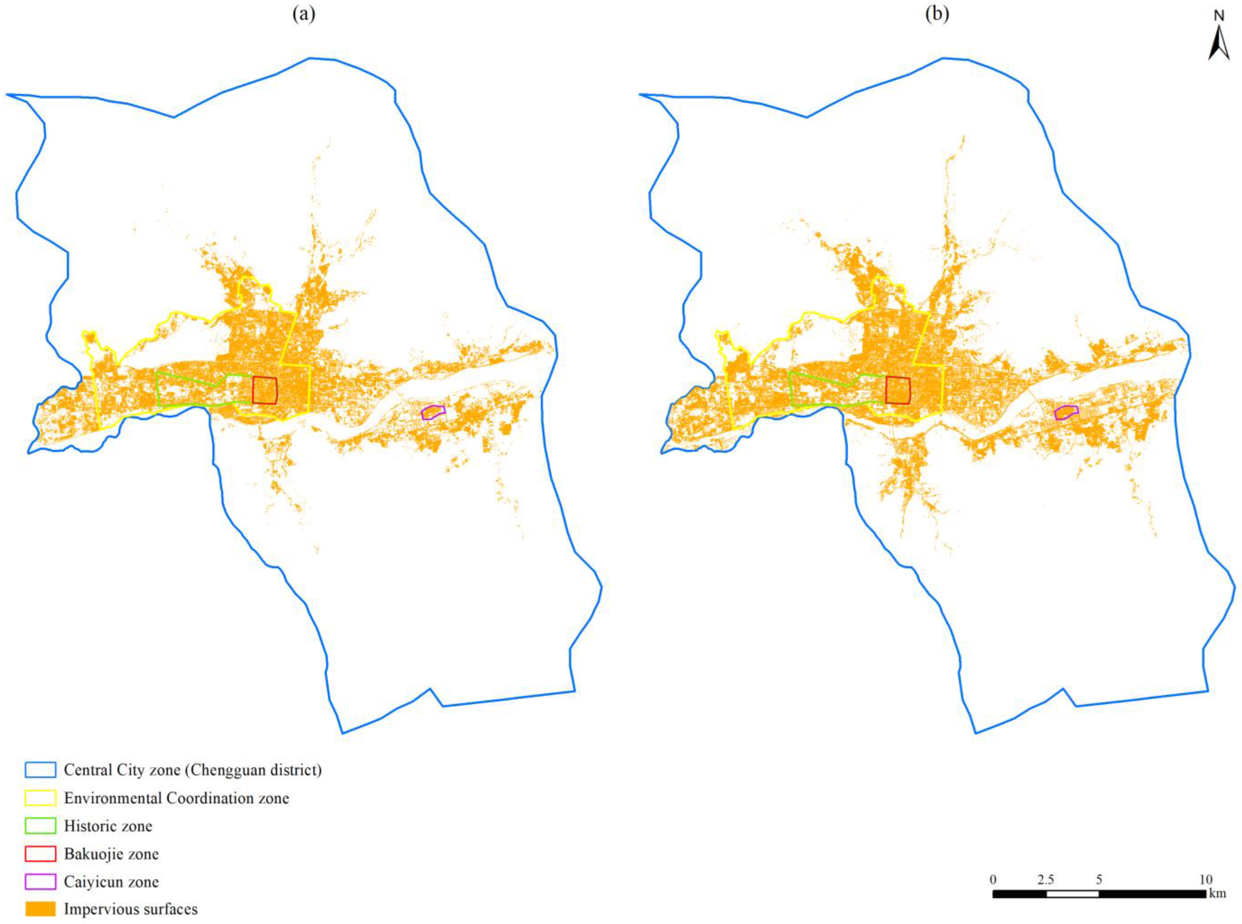
- The impervious surface area in Lhasa grew significantly from 51.149 km2 in 2014 to 63.299 km2 in 2021, with an overall increase rate of 23.75% and change rate of 1.74 km2/a. The Environmental Coordination, Historic, and Bakuojie zones, which are inside the Environmental Coordination zone, had increasing rates of 3.017%, 4.812%, and 4.246%, respectively. The Caiyicun zone, which is outside the Environmental Coordination zone, had an increasing rate of 23.16%.
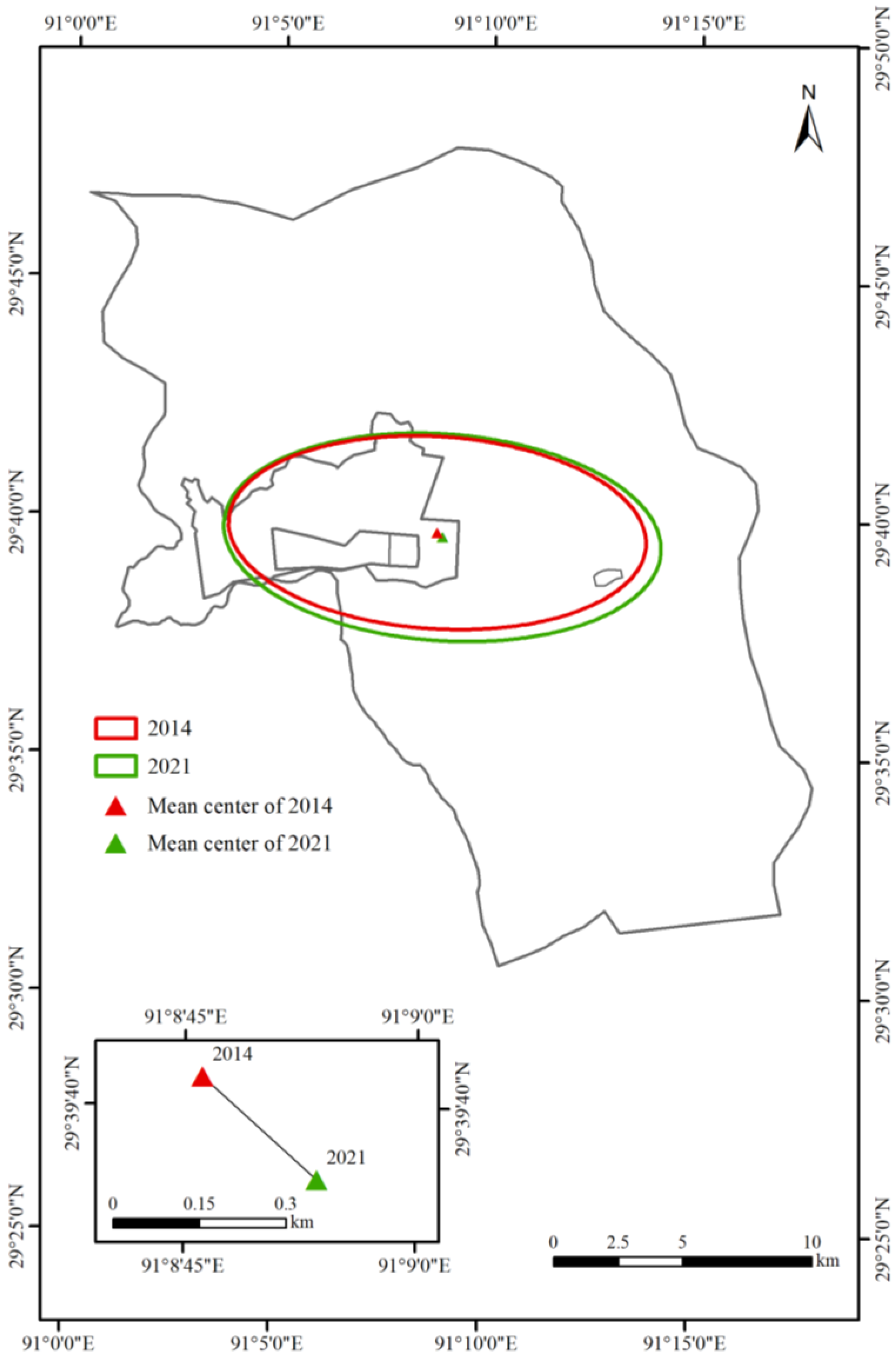
- Between 2014 and 2021, the shift of the ISMC revealed that the impervious surfaces of Lhasa expanded toward the southeast. The changes in SDE showed that the impervious surface distribution had a clear direction; the impervious surface expansion was oriented from west to east, and the impervious surfaces had an observable dispersion trend.
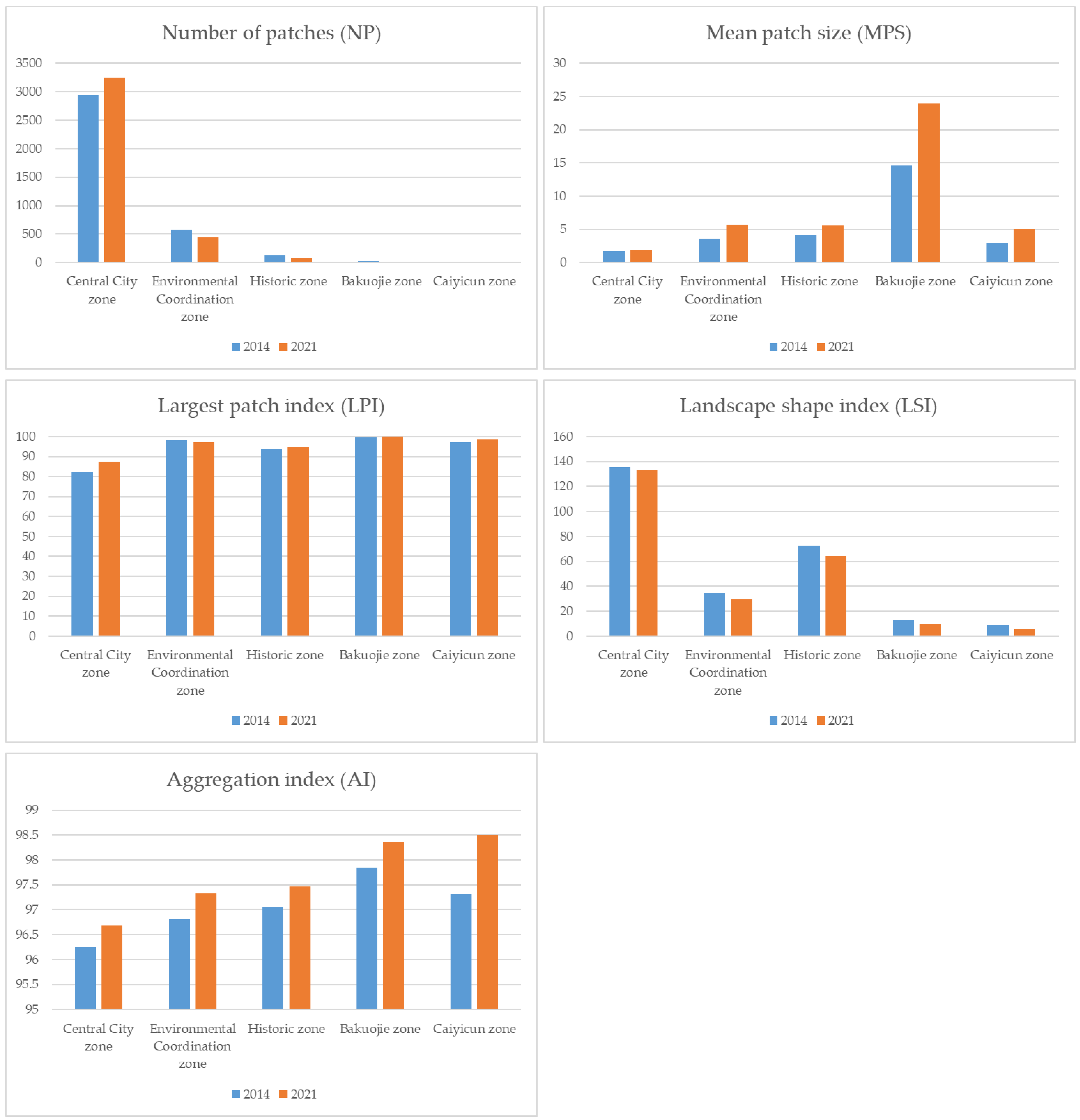
- In general, the landscape pattern in Lhasa City tends to be orderly, aggregated, and regularized. In the Central City zone, the impervious surface with an obvious expansion and dominance became more prominent. In the other four conservation zones, the dominance of impervious surfaces did not change significantly. Infilling and consolidation were the primary impervious surface development patterns in these areas. With the expansion of the impervious surface, the landscape in Lhasa City tended to be stable, regular, and aggregated, especially in the Bakuojie and Caiyicun zones.
Author Contributions
Funding
Institutional Review Board Statement
Informed Consent Statement
Data Availability Statement
Conflicts of Interest
References
- Arnold, C.L.; Gibbons, C.J. Impervious Surface Coverage: The Emergence of a Key Environmental Indicator. J. Am. Plan. Assoc. 1996, 62, 243–258. [Google Scholar] [CrossRef]
- Yuan, F.; Bauer, M.E. Comparison of Impervious Surface Area and Normalized Difference Vegetation Index as Indicators of Surface Urban Heat Island Effects in Landsat Imagery. Remote Sens. Environ. 2007, 106, 375–386. [Google Scholar] [CrossRef]
- Sekertekin, A.; Zadbagher, E. Simulation of Future Land Surface Temperature Distribution and Evaluating Surface Urban Heat Island Based on Impervious Surface Area. Ecol. Indic. 2021, 122, 107230. [Google Scholar] [CrossRef]
- Xu, J.; Zhao, Y.; Zhong, K.; Zhang, F.; Liu, X.; Sun, C. Measuring Spatio-Temporal Dynamics of Impervious Surface in Guangzhou, China, from 1988 to 2015, Using Time-Series Landsat Imagery. Sci. Total Environ. 2018, 627, 264–281. [Google Scholar] [CrossRef]
- Weng, Q. Remote Sensing of Impervious Surfaces in the Urban Areas: Requirements, Methods, and Trends. Remote Sens. Environ. 2012, 117, 34–49. [Google Scholar] [CrossRef]
- Xu, H.; Wang, M. Remote Sensing-Based Retrieval of Ground Impervious Surfaces. J. Remote Sens. 2016, 20, 1270–1289. [Google Scholar] [CrossRef]
- Alberti, M.; Booth, D.; Hill, K.; Coburn, B.; Avolio, C.; Coe, S.; Spirandelli, D. The Impact of Urban Patterns on Aquatic Ecosystems: An Empirical Analysis in Puget Lowland Sub-Basins. Landsc. Urban Plan. 2007, 80, 345–361. [Google Scholar] [CrossRef]
- Bektaş Balçik, F. Determining the Impact of Urban Components on Land Surface Temperature of Istanbul by Using Remote Sensing Indices. Environ. Monit. Assess. 2014, 186, 859–872. [Google Scholar] [CrossRef]
- Hua, L.; Zhang, X.; Nie, Q.; Sun, F.; Tang, L. The Impacts of the Expansion of Urban Impervious Surfaces on Urban Heat Islands in a Coastal City in China. Sustainability 2020, 12, 475. [Google Scholar] [CrossRef] [Green Version]
- Siddik, M.S.; Tulip, S.S.; Rahman, A.; Islam, M.N.; Haghighi, A.T.; Mustafa, S.M.T. The Impact of Land Use and Land Cover Change on Groundwater Recharge in Northwestern Bangladesh. J. Environ. Manag. 2022, 315, 115130. [Google Scholar] [CrossRef]
- Xiao, R.; Ouyang, Z.; Zheng, H.; Li, W.; Schienke, E.W.; Wang, X. Spatial Pattern of Impervious Surfaces and Their Impacts on Land Surface Temperature in Beijing, China. J. Environ. Sci. 2007, 19, 250–256. [Google Scholar] [CrossRef]
- Wu, W.; Li, C.; Liu, M.; Hu, Y.; Xiu, C. Change of Impervious Surface Area and Its Impacts on Urban Landscape: An Example of Shenyang between 2010 and 2017. Ecosyst. Health Sustain. 2020, 6, 1767511. [Google Scholar] [CrossRef]
- Zhang, S.; Yang, K.; Ma, Y.; Li, M. The Expansion Dynamics and Modes of Impervious Surfaces in the Guangdong-Hong Kong-Macau Bay Area, China. Land 2021, 10, 1167. [Google Scholar] [CrossRef]
- Seto, K.C.; Fragkias, M. Quantifying Spatiotemporal Patterns of Urban Land-Use Change in Four Cities of China with Time Series Landscape Metrics. Landsc. Ecol. 2005, 20, 871–888. [Google Scholar] [CrossRef]
- Peng, J.; Liu, Y.; Shen, H.; Xie, P.; Hu, X.; Wang, Y. Using Impervious Surfaces to Detect Urban Expansion in Beijing of China in 2000s. Chin. Geogr. Sci. 2016, 26, 229–243. [Google Scholar] [CrossRef] [Green Version]
- Zhou, W.; Huang, G.; Pickett, S.T.A.; Cadenasso, M.L. 90 Years of Forest Cover Change in an Urbanizing Watershed: Spatial and Temporal Dynamics. Landsc. Ecol. 2011, 26, 645–659. [Google Scholar] [CrossRef]
- Luck, M.; Wu, J. A Gradient Analysis of Urban Landscape Pattern: A Case Study from the Phoenix Metropolitan Region, Arizona, USA. Landsc. Ecol. 2002, 17, 327–339. [Google Scholar] [CrossRef]
- Kowe, P.; Pedzisai, E.; Gumindoga, W.; Rwasoka, D.T. An Analysis of Changes in the Urban Landscape Composition and Configuration in the Sancaktepe District of Istanbul Metropolitan City, Turkey Using Landscape Metrics and Satellite Data. Geocarto Int. 2015, 30, 506–519. [Google Scholar] [CrossRef]
- Feng, S.; Fan, F. Spatiotemporal Changes of Landscape Pattern Using Impervious Surface in Guangdong-Hong Kong-Macao Greater Bay Area, China. Chin. J. Appl. Ecol. 2018, 29, 2907–2914. [Google Scholar] [CrossRef]
- Hu, X.; Weng, Q. Impervious Surface Area Extraction from IKONOS Imagery Using an Object-Based Fuzzy Method. Geocarto Int. 2011, 26, 3–20. [Google Scholar] [CrossRef]
- Sebari, I.; He, D.-C. Automatic Fuzzy Object-Based Analysis of VHSR Images for Urban Objects Extraction. ISPRS J. Photogramm. Remote Sens. 2013, 79, 171–184. [Google Scholar] [CrossRef]
- Zhang, X.; Xiao, P.; Feng, X. Impervious Surface Extraction from High-Resolution Satellite Image Using Pixel- and Object-Based Hybrid Analysis. Int. J. Remote Sens. 2013, 34, 4449–4465. [Google Scholar] [CrossRef]
- Ma, L.; Li, M.; Ma, X.; Cheng, L.; Du, P.; Liu, Y. A Review of Supervised Object-Based Land-Cover Image Classification. ISPRS J. Photogramm. Remote Sens. 2017, 130, 277–293. [Google Scholar] [CrossRef]
- Mallinis, G.; Koutsias, N.; Tsakiri-Strati, M.; Karteris, M. Object-Based Classification Using Quickbird Imagery for Delineating Forest Vegetation Polygons in a Mediterranean Test Site. ISPRS J. Photogramm. Remote Sens. 2008, 63, 237–250. [Google Scholar] [CrossRef]
- Laliberte, A.S.; Rango, A.; Havstad, K.M.; Paris, J.F.; Beck, R.F.; McNeely, R.; Gonzalez, A.L. Object-Oriented Image Analysis for Mapping Shrub Encroachment from 1937 to 2003 in Southern New Mexico. Remote Sens. Environ. 2004, 93, 198–210. [Google Scholar] [CrossRef]
- Myint, S.W.; Gober, P.; Brazel, A.; Grossman-Clarke, S.; Weng, Q. Per-Pixel vs. Object-Based Classification of Urban Land Cover Extraction Using High Spatial Resolution Imagery. Remote Sens. Environ. 2011, 115, 1145–1161. [Google Scholar] [CrossRef]
- Lichtblau, E.; Oswald, C.J. Classification of Impervious Land-Use Features Using Object-Based Image Analysis and Data Fusion. Comput. Environ. Urban Syst. 2019, 75, 103–116. [Google Scholar] [CrossRef]
- Feng, S.; Fan, F. Impervious Surface Extraction Based on Different Methods from Multiple Spatial Resolution Images: A Comprehensive Comparison. Int. J. Digit. Earth 2021, 14, 1148–1174. [Google Scholar] [CrossRef]
- Maxwell, A.E.; Warner, T.A.; Strager, M.P.; Conley, J.F.; Sharp, A.L. Assessing Machine-Learning Algorithms and Image- and Lidar-Derived Variables for GEOBIA Classification of Mining and Mine Reclamation. Int. J. Remote Sens. 2015, 36, 954–978. [Google Scholar] [CrossRef]
- Colkesen, I.; Kavzoglu, T. Comparative Evaluation of Decision-Forest Algorithms in Object-Based Land Use and Land Cover Mapping. In Spatial Modeling in GIS and R for Earth and Environmental Sciences; Elsevier: Amsterdam, The Netherlands, 2019; pp. 499–517. [Google Scholar]
- Li, M.; Ma, L.; Blaschke, T.; Cheng, L.; Tiede, D. A Systematic Comparison of Different Object-Based Classification Techniques Using High Spatial Resolution Imagery in Agricultural Environments. Int. J. Appl. Earth Obs. Geoinf. 2016, 49, 87–98. [Google Scholar] [CrossRef]
- Talukdar, S.; Singha, P.; Mahato, S.; Shahfahad; Pal, S.; Liou, Y.-A.; Rahman, A. Land-Use Land-Cover Classification by Machine Learning Classifiers for Satellite Observations—A Review. Remote Sens. 2020, 12, 1135. [Google Scholar] [CrossRef] [Green Version]
- Gao, Q.; Guo, Y.; Xu, H.; Ganjurjav, H.; Li, Y.; Wan, Y.; Qin, X.; Ma, X.; Liu, S. Climate Change and Its Impacts on Vegetation Distribution and Net Primary Productivity of the Alpine Ecosystem in the Qinghai-Tibetan Plateau. Sci. Total Environ. 2016, 554, 34–41. [Google Scholar] [CrossRef] [PubMed]
- Fu, S.; Zhang, X.; Kuang, W.; Guo, C. Characteristics of Changes in Urban Land Use and Efficiency Evaluation in the Qinghai–Tibet Plateau from 1990 to 2020. Land 2022, 11, 757. [Google Scholar] [CrossRef]
- Chen, T.; Jiao, J.; Wei, W.; Li, J.; Zhang, Z.; Yang, H.; Ma, H. Spatiotemporal Variation in the Land Use/Cover of Alluvial Fans in Lhasa River Basin, Qinghai–Tibet Plateau. Agriculture 2023, 13, 312. [Google Scholar] [CrossRef]
- Wu, J.; Sun, C.; Fan, F. An Analysis of the Spatiotemporal Distribution of Impervious Surface and Land Surface Temperature in Plateau Areas. J. South China Norm. Univ. Sci. Ed. 2020, 52, 92–100. [Google Scholar]
- Li, D.; Tian, P.; Luo, H.; Hu, T.; Dong, B.; Cui, Y.; Khan, S.; Luo, Y. Impacts of Land Use and Land Cover Changes on Regional Climate in the Lhasa River Basin, Tibetan Plateau. Sci. Total Environ. 2020, 742, 140570. [Google Scholar] [CrossRef]
- Han, W.; Lu, H.; Liu, G.; Wang, J.; Su, X. Quantifying Degradation Classifications on Alpine Grassland in the Lhasa River Basin, Qinghai-Tibetan Plateau. Sustainability 2019, 11, 7067. [Google Scholar] [CrossRef] [Green Version]
- Chen, J.; Kong, Y.; Mei, Y. Riverine Health Assessment Using Coordinated Development Degree Model Based on Natural and Social Functions in the Lhasa River, China. Int. J. Environ. Res. Public Health 2022, 19, 7182. [Google Scholar] [CrossRef] [PubMed]
- Li, X.; Hou, W.; Liu, M.; Yu, Z. Traditional Thoughts and Modern Development of the Historical Urban Landscape in China: Lessons Learned from the Example of Pingyao Historical City. Land 2022, 11, 247. [Google Scholar] [CrossRef]
- Arkaraprasertkul, N. Gentrifying Heritage: How Historic Preservation Drives Gentrification in Urban Shanghai. Int. J. Herit. Stud. 2019, 25, 882–896. [Google Scholar] [CrossRef]
- Chen, H.; Wang, L.; Waley, P. The Right to Envision the City? The Emerging Vision Conflicts in Redeveloping Historic Nanjing, China. Urban Aff. Rev. 2020, 56, 1746–1778. [Google Scholar] [CrossRef]
- Appendino, F. Balancing Heritage Conservation and Sustainable Development—The Case of Bordeaux. IOP Conf. Ser. Mater. Sci. Eng. 2017, 245, 062002. [Google Scholar] [CrossRef] [Green Version]
- Ragheb, A.; Aly, R.; Ahmed, G. Toward Sustainable Urban Development of Historical Cities: Case Study of Fouh City, Egypt. Ain Shams Eng. J. 2022, 13, 101520. [Google Scholar] [CrossRef]
- Zhou, Q.; Yu, Q.; Liu, J.; Wu, W.; Tang, H. Perspective of Chinese GF-1 High-Resolution Satellite Data in Agricultural Remote Sensing Monitoring. J. Integr. Agric. 2017, 16, 242–251. [Google Scholar] [CrossRef]
- Chang, S.; Wu, B.; Yan, N.; Zhu, J.; Wen, Q.; Xu, F. A Refined Crop Drought Monitoring Method Based on the Chinese GF-1 Wide Field View Data. Sensors 2018, 18, 1297. [Google Scholar] [CrossRef] [Green Version]
- Ma, L.; Fu, T.; Blaschke, T.; Li, M.; Tiede, D.; Zhou, Z.; Ma, X.; Chen, D. Evaluation of Feature Selection Methods for Object-Based Land Cover Mapping of Unmanned Aerial Vehicle Imagery Using Random Forest and Support Vector Machine Classifiers. ISPRS Int. J. Geo-Inf. 2017, 6, 51. [Google Scholar] [CrossRef] [Green Version]
- Guan, H.; Li, J.; Chapman, M.; Deng, F.; Ji, Z.; Yang, X. Integration of Orthoimagery and Lidar Data for Object-Based Urban Thematic Mapping Using Random Forests. Int. J. Remote Sens. 2013, 34, 5166–5186. [Google Scholar] [CrossRef]
- Lebourgeois, V.; Dupuy, S.; Vintrou, É.; Ameline, M.; Butler, S.; Bégué, A. A Combined Random Forest and OBIA Classification Scheme for Mapping Smallholder Agriculture at Different Nomenclature Levels Using Multisource Data (Simulated Sentinel-2 Time Series, VHRS and DEM). Remote Sens. 2017, 9, 259. [Google Scholar] [CrossRef] [Green Version]
- Song, Q.; Hu, Q.; Zhou, Q.; Hovis, C.; Xiang, M.; Tang, H.; Wu, W. In-Season Crop Mapping with GF-1/WFV Data by Combining Object-Based Image Analysis and Random Forest. Remote Sens. 2017, 9, 1184. [Google Scholar] [CrossRef] [Green Version]
- Phiri, D.; Morgenroth, J.; Xu, C.; Hermosilla, T. Effects of Pre-Processing Methods on Landsat OLI-8 Land Cover Classification Using OBIA and Random Forests Classifier. Int. J. Appl. Earth Obs. Geoinf. 2018, 73, 170–178. [Google Scholar] [CrossRef]
- Breiman, L. Random Forests. Mach. Learn. 2001, 45, 5–32. [Google Scholar] [CrossRef] [Green Version]
- Pal, M. Random Forest Classifier for Remote Sensing Classification. Int. J. Remote Sens. 2005, 26, 217–222. [Google Scholar] [CrossRef]
- Rokach, L. Decision Forest: Twenty Years of Research. Inf. Fusion 2016, 27, 111–125. [Google Scholar] [CrossRef]
- Olofsson, P.; Foody, G.M.; Herold, M.; Stehman, S.V.; Woodcock, C.E.; Wulder, M.A. Good Practices for Estimating Area and Assessing Accuracy of Land Change. Remote Sens. Environ. 2014, 148, 42–57. [Google Scholar] [CrossRef]
- Udali, A.; Lingua, E.; Persson, H.J. Assessing Forest Type and Tree Species Classification Using Sentinel-1 C-Band SAR Data in Southern Sweden. Remote Sens. 2021, 13, 3237. [Google Scholar] [CrossRef]
- Kendall, M.G. Rank Correlation Methods; Griffin: London, UK, 1948. [Google Scholar]
- Xiang, K.; Zhao, A.; Liu, H.; Zhang, X.; Zhang, A.; Tian, X.; Jin, Z. Spatiotemporal Evolution and Coupling Pattern Analysis of Urbanization and Ecological Environmental Quality of the Chinese Loess Plateau. Sustainability 2022, 14, 7236. [Google Scholar] [CrossRef]
- Estoque, R.C.; Murayama, Y.; Myint, S.W. Effects of Landscape Composition and Pattern on Land Surface Temperature: An Urban Heat Island Study in the Megacities of Southeast Asia. Sci. Total Environ. 2017, 577, 349–359. [Google Scholar] [CrossRef]
- People’s Government of Lhasa Municipality. Overall Urban Plan for Lhasa(2009–2020). 2017. Available online: https://www.docin.com/p-1894397395.html (accessed on 18 March 2023).
- People’s Government of Lhasa Municipality. Regulations on the Protection of Old Town of Lhasa. 2013. Available online: https://flk.npc.gov.cn/detail2.html?NDAyOGFiY2M2MTI3Nzc5MzAxNjEyODFjZGZhZTVlMTM%3D (accessed on 18 March 2023).
- People’s Government of Lhasa Municipality. Regulations on the Protection of Ancient Village of Lhasa. 2016. Available online: https://flk.npc.gov.cn/detail2.html?ZmY4MDgwODE3MWU5ZTE4MTAxNzIwMTljODU1MjJkMWE (accessed on 18 March 2023).
- People’s Government of Lhasa Municipality. Historic and Cultural City Protection Plan for Lhasa. 2019. Available online: http://www.xizang.gov.cn/rsxz/msgj/201912/t20191218_126510.html (accessed on 18 March 2023).
- Li, G.; Sun, S.; Fang, C. The Varying Driving Forces of Urban Expansion in China: Insights from a Spatial-Temporal Analysis. Landsc. Urban Plan. 2018, 174, 63–77. [Google Scholar] [CrossRef]
- Shahtahmassebi, A.R.; Song, J.; Zheng, Q.; Blackburn, G.A.; Wang, K.; Huang, L.Y.; Pan, Y.; Moore, N.; Shahtahmassebi, G.; Sadrabadi Haghighi, R.; et al. Remote Sensing of Impervious Surface Growth: A Framework for Quantifying Urban Expansion and Re-Densification Mechanisms. Int. J. Appl. Earth Obs. Geoinf. 2016, 46, 94–112. [Google Scholar] [CrossRef] [Green Version]
- Ma, Q.; He, C.; Wu, J. Behind the Rapid Expansion of Urban Impervious Surfaces in China: Major Influencing Factors Revealed by a Hierarchical Multiscale Analysis. Land Use Policy 2016, 59, 434–445. [Google Scholar] [CrossRef]
- Ma, Y.; Xu, R. Remote Sensing Monitoring and Driving Force Analysis of Urban Expansion in Guangzhou City, China. Habitat Int. 2010, 34, 228–235. [Google Scholar] [CrossRef]
- Chen, T.; Lang, W.; Chan, E.; Philipp, C.H. Lhasa: Urbanising China in the Frontier Regions. Cities 2018, 74, 343–353. [Google Scholar] [CrossRef]
- Zhou, P.; Xie, Y.; Gao, Z.; Jiang, G. Changes and Driving Forces of Impervious Surfaces in Xi’an City. Bull. Soil Water Conserv. 2020, 40, 274–281. [Google Scholar] [CrossRef]
- Tibet Statistical Bureau. Tibet Statistical Yearbook; China Statistics Press: Beijing, China, 2022; ISBN 9787503796791.
- Tibet Statistical Bureau. Tibet Statistical Yearbook; China Statistics Press: Beijing, China, 2015; ISBN 9787503774768.
- The State Council Information Office of the People’s Republic of China. Ecological Progress on the Qinghai-Tibet Plateau; The State Council Information Office of the People’s Republic of China: Beijing, China, 2018. Available online: http://english.www.gov.cn/archive/white_paper/2018/07/18/content_281476227186598.htm (accessed on 18 March 2023).


| Acquisition Date | Cloud Cover | Center Latitude and Longitude | Sensor |
|---|---|---|---|
| 12 February 2014 | 0 | 91.0 E, 29.7 N | PMS |
| 12 February 2014 | 1% | 91.3 E, 29.6 N | PMS |
| 5 February 2021 | 1% | 91.1 E, 29.7 N | PMS |
| 5 February 2021 | 1% | 91.1 E, 29.4 N | PMS |
| Landscape Indices | Calculation and Description |
|---|---|
| Number of patches (NP) | where ni is the number of patches in the landscape of patch type. |
| Mean patch size (MPS) | where n refers to the number of patches and ai is the area of patch i. |
| Largest patch index (LPI) | where aij refers to the area (m2) of patch ij. |
| Landscape shape index (LSI) | where E is the total length (m) of the edge between patch types i and k in the landscape; this includes the entire landscape boundary and some or all background edge segments that involve patch types i. |
| Aggregation index (AI) | where gii is the number of like adjacencies (joins) between pixels of patch type i based on the single-count method and max gii refers to the maximum number of like adjacencies (joins) between pixels of patch type i based on the single-count method. Pi is the proportion of landscape comprising patch type i. |
| 2014 | Google Earth Images | ||||
|---|---|---|---|---|---|
| Classified results | Classification | Impervious surface | Non-impervious surface | Sum | User’s accuracy |
| Impervious surface | 92 | 9 | 101 | 91.09% | |
| Non-impervious surface | 8 | 391 | 399 | 97.99% | |
| SUM | 100 | 266 | 500 | ||
| Producer’s accuracy | 92.00% | 97.75% | |||
| OA | 96.60% | ||||
| KAPPA | 89.41% | ||||
| 2021 | Google Earth Images | ||||
| Classified results | Classification | Impervious surface | Non-impervious surface | Sum | User’s accuracy |
| Impervious surface | 125 | 12 | 137 | 91.24% | |
| Non-impervious surface | 9 | 354 | 363 | 97.52% | |
| SUM | 134 | 366 | 500 | ||
| Producer’s accuracy | 93.28% | 96.72% | |||
| OA | 95.80% | ||||
| KAPPA | 89.37% | ||||
| Zone | Impervious Surface Area (km2) | Impervious Surface Coverage | Increase Rate | ||
|---|---|---|---|---|---|
| 2014 | 2021 | 2014 | 2021 | ||
| Central City zone | 51.149 | 63.299 | 9.975% | 12.345% | 23.755% |
| Historic zone | 4.506 | 4.642 | 65.575% | 67.554% | 3.017% |
| Environmental Coordination zone | 23.827 | 24.973 | 55.800% | 58.485% | 4.812% |
| Bakuojie zone | 1.150 | 1.199 | 83.967% | 87.532% | 4.246% |
| Caiyicun zone | 0.328 | 0.404 | 67.434% | 83.050% | 23.157% |
| Year | Long Axis (m) | Short Axis (m) | Orientation (°) | Long Axis/Short Axis |
|---|---|---|---|---|
| 2014 | 8108.176 | 3732.333 | 93.634 | 2.172 |
| 2021 | 8493.819 | 4009.020 | 94.053 | 2.119 |
Disclaimer/Publisher’s Note: The statements, opinions and data contained in all publications are solely those of the individual author(s) and contributor(s) and not of MDPI and/or the editor(s). MDPI and/or the editor(s) disclaim responsibility for any injury to people or property resulting from any ideas, methods, instructions or products referred to in the content. |
© 2023 by the authors. Licensee MDPI, Basel, Switzerland. This article is an open access article distributed under the terms and conditions of the Creative Commons Attribution (CC BY) license (https://creativecommons.org/licenses/by/4.0/).
Share and Cite
Wang, S.; Tan, X.; Fan, F. Changes in Impervious Surfaces in Lhasa City, a Historical City on the Qinghai–Tibet Plateau. Sustainability 2023, 15, 5510. https://doi.org/10.3390/su15065510
Wang S, Tan X, Fan F. Changes in Impervious Surfaces in Lhasa City, a Historical City on the Qinghai–Tibet Plateau. Sustainability. 2023; 15(6):5510. https://doi.org/10.3390/su15065510
Chicago/Turabian StyleWang, Sishi, Xin Tan, and Fenglei Fan. 2023. "Changes in Impervious Surfaces in Lhasa City, a Historical City on the Qinghai–Tibet Plateau" Sustainability 15, no. 6: 5510. https://doi.org/10.3390/su15065510
APA StyleWang, S., Tan, X., & Fan, F. (2023). Changes in Impervious Surfaces in Lhasa City, a Historical City on the Qinghai–Tibet Plateau. Sustainability, 15(6), 5510. https://doi.org/10.3390/su15065510


