Optimal Scale Selection and an Object-Oriented Method Used for Measuring and Monitoring the Extent of Land Desertification
Abstract
:1. Introduction
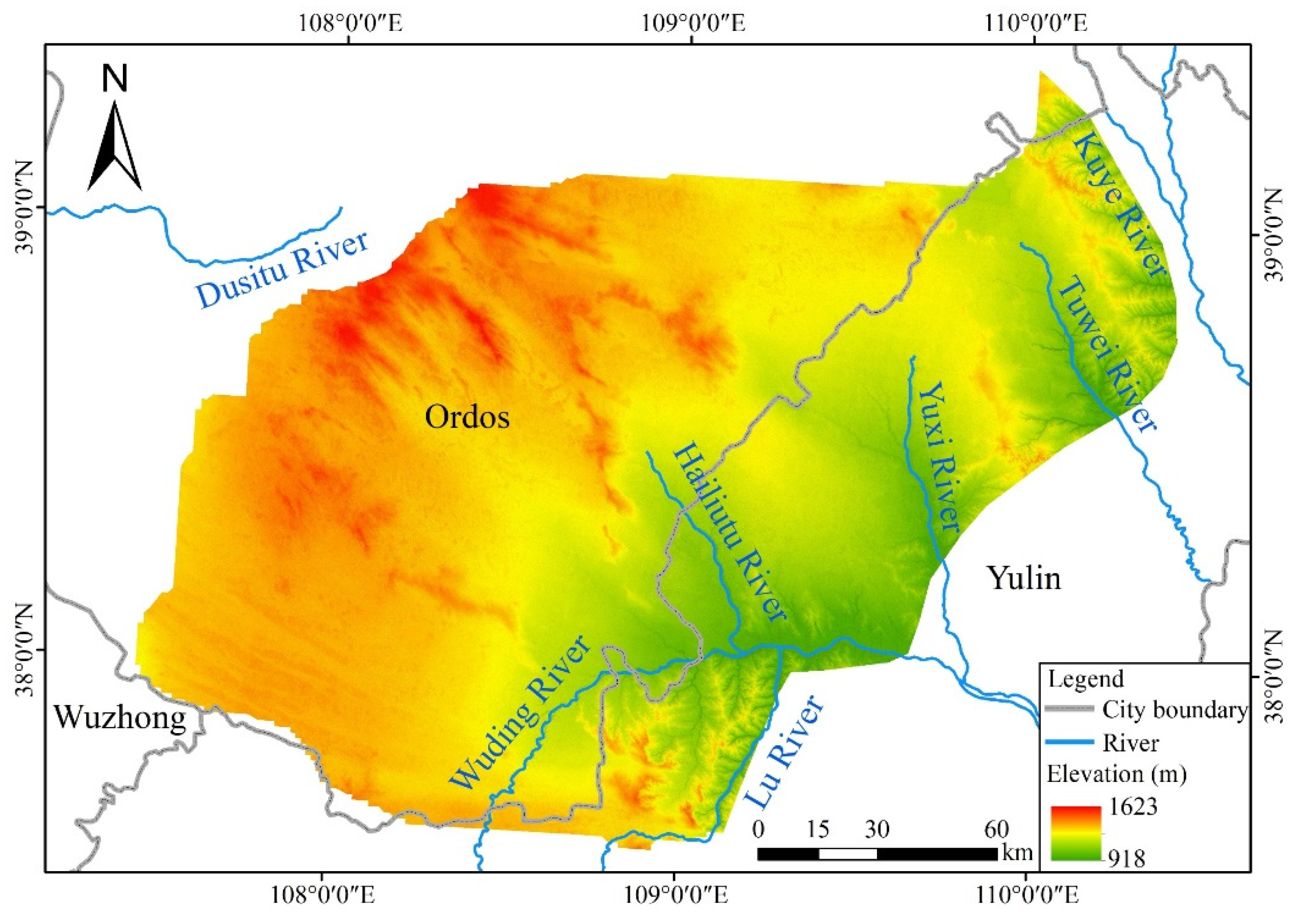
2. Study Area and Data Sources
2.1. Study Area
2.2. Data Collection and Pre-Processing Steps
3. Methods
3.1. Interpretations of the Signs of Desertification
3.2. Segmentation Algorithms
3.2.1. Mean Variance Method
3.2.2. Maximum Area Method
3.3. Characteristic Variables
3.4. Random Forest Classification
3.5. Accuracy Evaluation
4. Results and Analysis
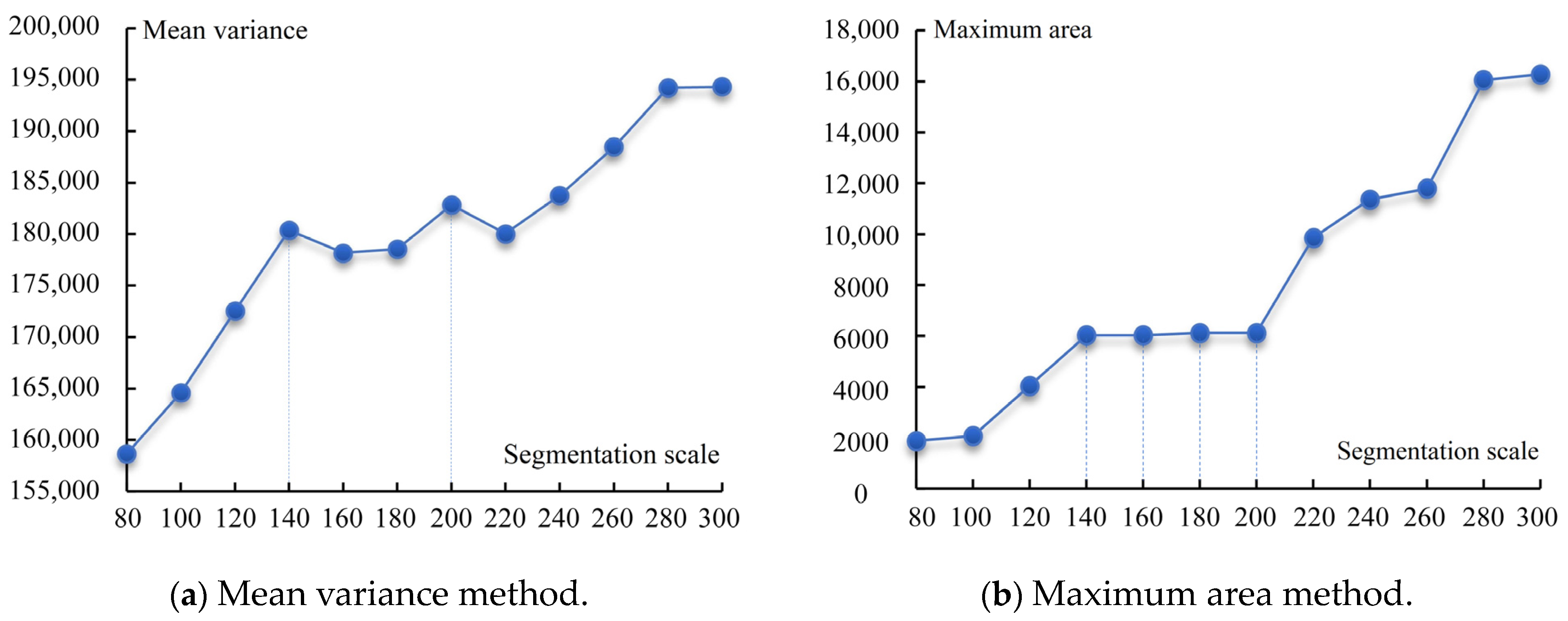
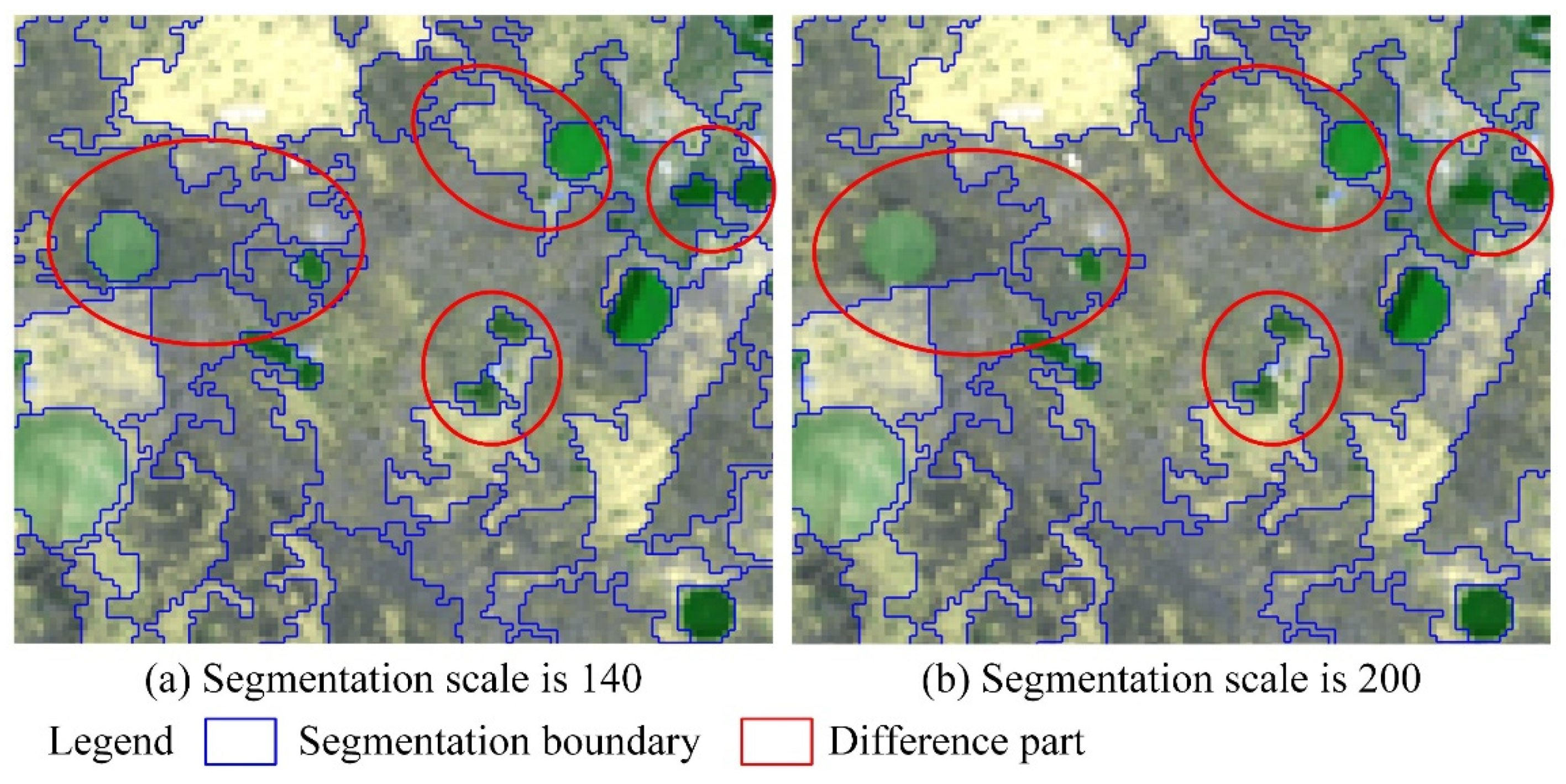
4.1. Optimal Segmentation Scale
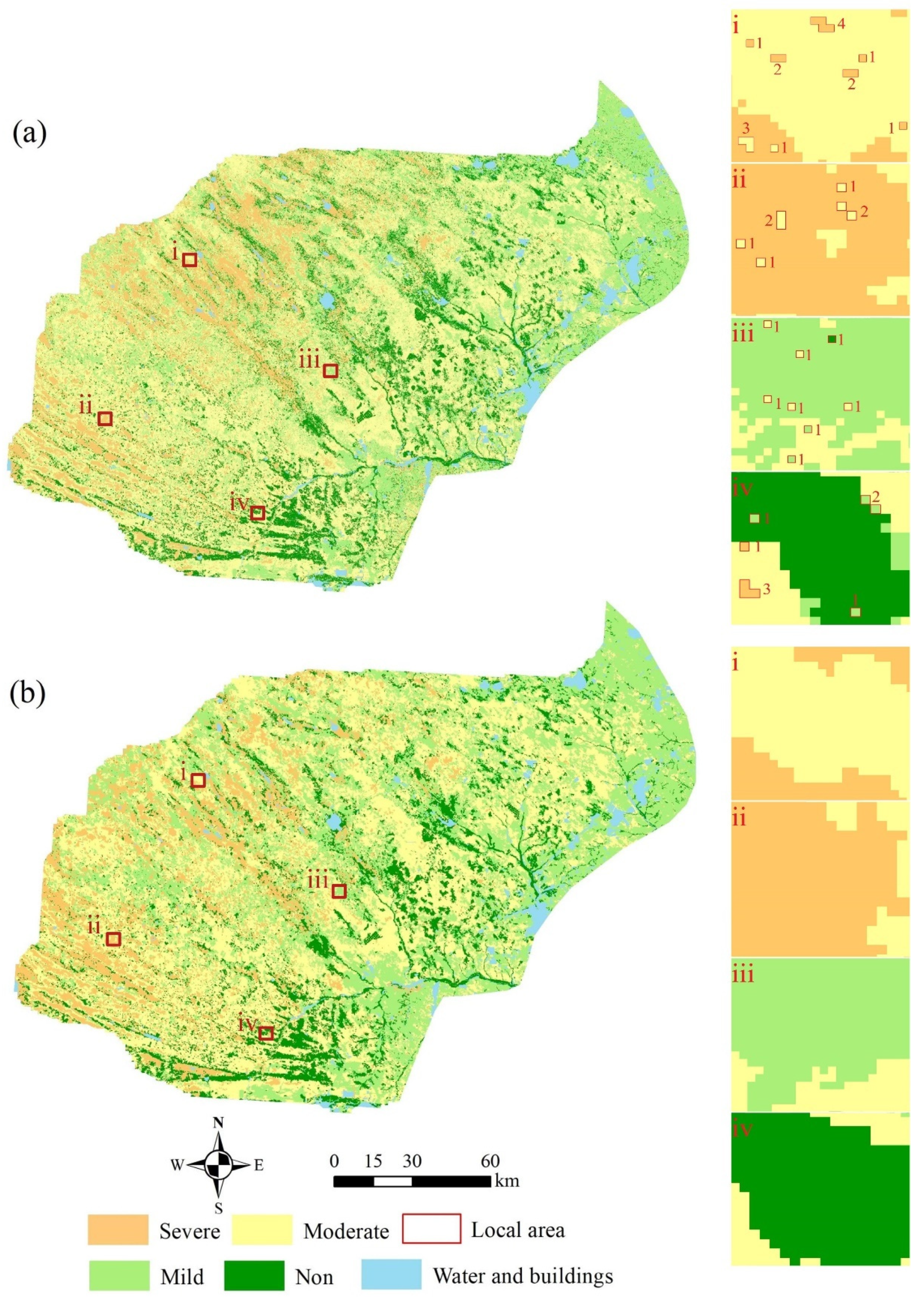
4.2. Analysis of Classification Results
4.3. Validation of Desertification Classification Results
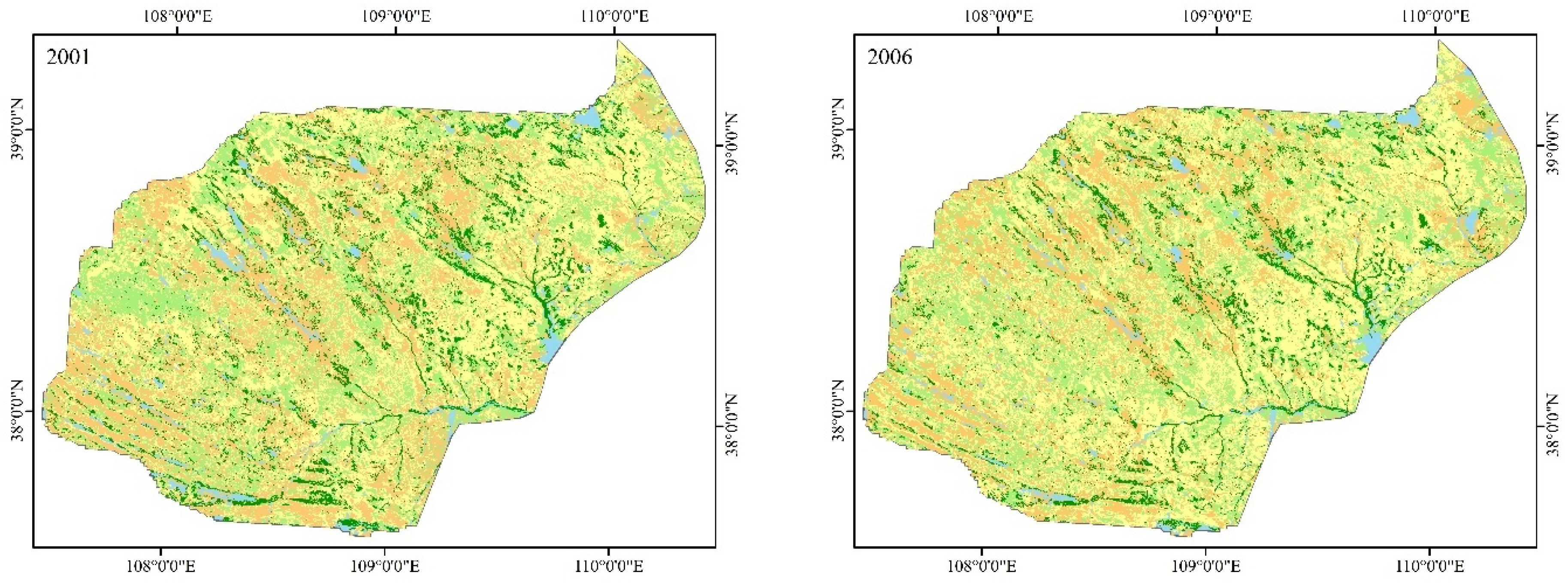
4.4. Spatial Distribution of Land Desertification Areas in Mu Us from 2001 to 2021
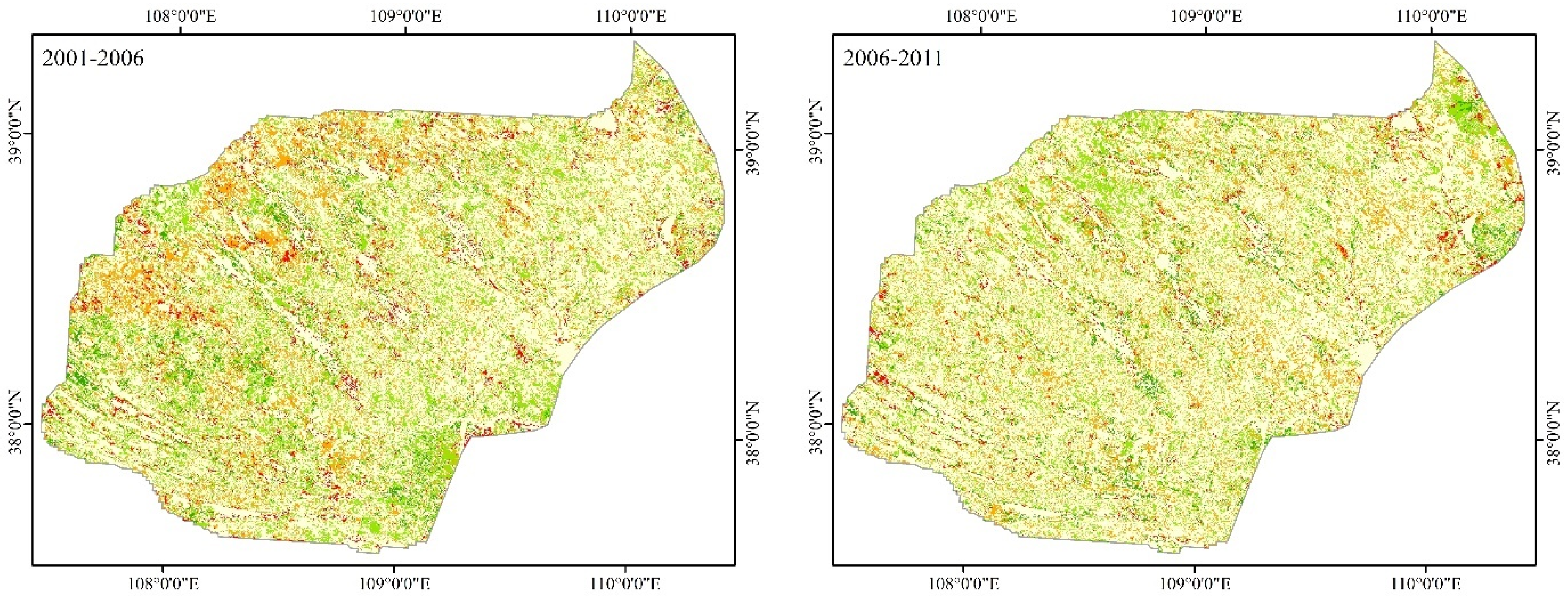
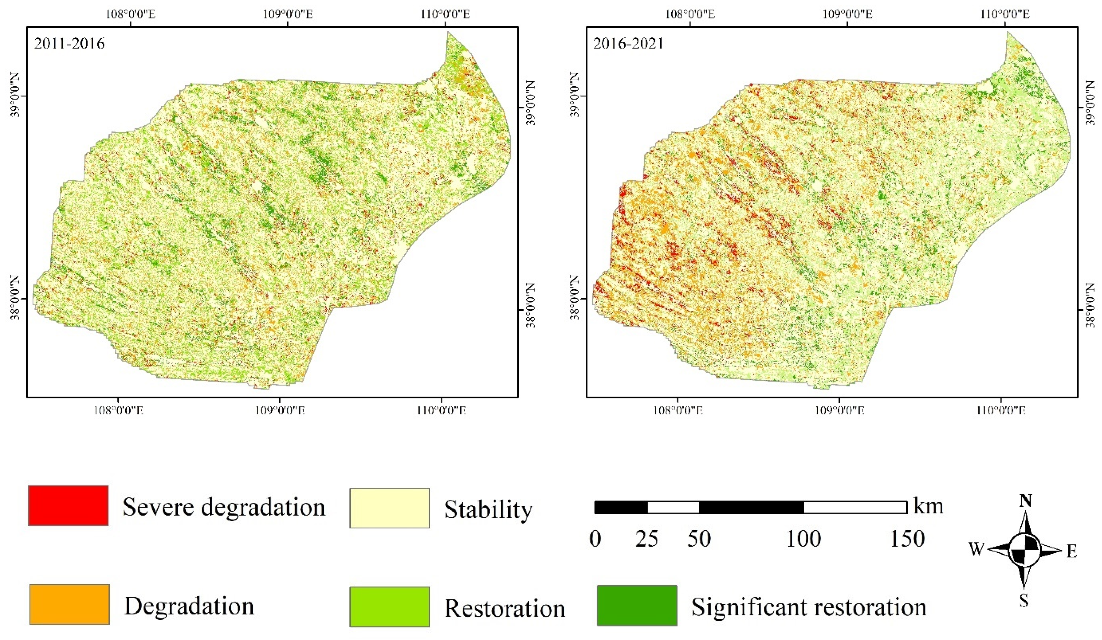
4.5. Dynamic Changes in Desertification in Mu Us Desert from 2001 to 2021
5. Discussion
6. Conclusions
Author Contributions
Funding
Institutional Review Board Statement
Informed Consent Statement
Data Availability Statement
Conflicts of Interest
References
- Zhou, R.P. Zonation and spatiotemporal evolution of China’s desertification. J. Geo-Inf. Sci. 2019, 21, 675–687. [Google Scholar] [CrossRef]
- Gebru, B.M.; Lee, W.K.; Khamzina, A.; Wang, W.S.; Cha, S.; Song, C.; Munkhansan, L. Spatiotemporal multi-index analysis of desertification in dry Afromontane forests of northern Ethiopia. Environ. Dev. Sustain. 2021, 23, 423–450. [Google Scholar] [CrossRef]
- Wei, W.; Guo, Z.C.; Shi, P.J.; Zhou, L.; Wang, X.F.; Li, Z.Y.; Pang, S.F.; Xie, B.B. Spatiotemporal changes of land desertification sensitivity in northwest China from 2000 to 2017. J. Geogr. Sci. 2021, 31, 46–68. [Google Scholar] [CrossRef]
- Bai, Z.F.; Han, L.; Jiang, X.H.; Liu, M.; Li, L.Z.; Liu, H.Q.; Lu, J.X. Spatiotemporal evolution of desertification based on integrated remote sensing indices in Duolun County, Inner Mongolia. Ecol. Infor. 2022, 70, 101750. [Google Scholar] [CrossRef]
- Zhan, Q.Q.; Zhao, W.; Yang, M.J.; Xiong, D.H. A long-term record (1995–2019) of the dynamics of land desertification in the middle reaches of Yarlung Zangbo River basin derived from Landsat data. Geogr. Sustain. 2021, 2, 12–21. [Google Scholar] [CrossRef]
- Zhao, Y.Y.; Gao, G.L.; Qin, S.G.; Yu, M.H.; Ding, G.D. Desertification detection and the evaluation indicators: A review. J. Arid Land Resour. Environ. 2019, 33, 81–87. [Google Scholar] [CrossRef]
- Feng, X.W.; Wu, G.X.; Wang, T.J.; Chai, Z.F. Sandy desertification process and dynamic assessment in Hunshandake sandland. J. Arid Land Resour. Environ. 2020, 34, 109–116. [Google Scholar] [CrossRef]
- Liu, C.; Li, C.Z.; Li, S.H.; Fu, X.L.; Shi, Q.D. Desertification analysis based on grid accumulation method in Tarim Basin, China. Arid Land Geogr. 2021, 44, 197–207. [Google Scholar] [CrossRef]
- Wu, Z.H.; Lei, S.G.; Bian, Z.F.; Huang, J.; Zhang, Y. Study of the desertification index based on the albedo-MSAVI feature space for semi-arid steppe region. Environ. Earth Sci. 2019, 78, 232. [Google Scholar] [CrossRef]
- Lamchin, M.; Lee, J.Y.; Lee, W.K.; Lee, J.E.; Kim, M.; Lim, H.C.; Choi, H.A.; Kim, S.O. Assessment of land cover change and desertification using remote sensing technology in a local region of Mongolia. Adv. Space Res. 2016, 57, 64–77. [Google Scholar] [CrossRef]
- Wang, S.X.; Han, L.S.; Yang, J.; Li, Y.; Zhao, Q.; Liu, Y.X.Y.; Wu, H. An improved method of combining multi-indicator desertification classification. Bull. Surv. Mapp. 2021, 0, 8–12. [Google Scholar] [CrossRef]
- Abduljabbar, H.M.; Hatem, A.J.; Al-Jasim, A.A.N. Desertification monitoring in the south-west of Iraqi using fuzzy inference system. NeuroQuantology 2020, 18, 1. [Google Scholar] [CrossRef]
- Eskandari Dameneh, H.; Gholami, H.; Telfer, M.W.; Comino, J.R.; Collins, A.L.; Jansen, J.D. Desertification of Iran in the early twenty-first century: Assessment using climate and vegetation indices. Sci. Rep. 2021, 11, 20548. [Google Scholar] [CrossRef]
- Rouibah, K.; Belabbas, M. Applying multi-index approach from Sentinel-2 imagery to extract Urban area in dry season (semi-arid land in north east Algeria). Rev. De Teledetección 2020, 56, 89–101. [Google Scholar] [CrossRef]
- Vendruscolo, J.; Marin, A.M.; dos Santos Felix, E.; Ferreira, K.R.; Cavalheiro, W.C.S.; Fernandes, I.M. Monitoring desertification in semiarid Brazil: Using the desertification degree index (DDI). Land Degrad. Dev. 2021, 32, 684–698. [Google Scholar] [CrossRef]
- Fan, Z.M.; Li, S.B. Spatio-temporal pattern change of desertification and its driving factors analysis in China-Mongolia-Russia economic corridor. Acta Ecol. Sin. 2020, 40, 4252–4263. [Google Scholar] [CrossRef]
- Wei, W.; Yu, X.; Zhang, M.Z.; Zhang, J.; Yuan, T.; Liu, C.F. Dynamics of desertification in the lower reaches of Shiyang River Basin, Northwest China during 1995–2018. Chin. J. Appl. Ecol. 2021, 32, 2098–2106. [Google Scholar] [CrossRef]
- Wei, H.S.; Wang, J.L.; Cheng, K.; Li, G.; Ochir, A.; Davaasuren, D.; Chonokhuu, S. Desertification information extraction based on feature space combinations on the mongolian plateau. Remote Sens. 2018, 10, 1614. [Google Scholar] [CrossRef] [Green Version]
- Liu, Z.J. Vegetation Extraction Method Using UAN Remote Sensing Image. Master’s Thesis, Henan University, Zhengzhou, China, 2017. [Google Scholar]
- Zhan, Q.Q.; Zhao, W.; Yang, M.J.; Fu, H.; Li, X.J.; Xiong, D.H. Identification of sandy land in the midstream of the Yarlung Zangbo River. J. Geo-Inf. Sci. 2022, 24, 391–404. [Google Scholar] [CrossRef]
- Nie, Q.; Qi, K.K.; Zhao, Y.F. Object-oriented classification of high-resolution image combining super-pixel segmentation. Bull. Surv. Mapp. 2021, 0, 44–49. [Google Scholar] [CrossRef]
- Liu, J.L.; Chen, Z.; Gao, J.P.; Gao, X.L.; Sun, Z.Q. Research on the method of determining the optimal segmentation scale for tree species classification of high-resolution image. Sci. Silvae Sin. 2019, 55, 95–104. [Google Scholar] [CrossRef]
- Peng, J.Y.; Wang, X.J.; Zhu, L.; Zhao, C.Y.; Xu, X.L. Information extraction of desert surface types based on UAV image. Arid Zone Res. 2019, 36, 771–780. [Google Scholar] [CrossRef]
- Wen, X.; Jia, M.M.; Li, X.Y.; Wang, Z.M.; Zhong, C.R.; Feng, E.H. Identification of mangrove canopy species based on visible unmanned aerial vehicle images. J. For. Environ. 2020, 40, 486–496. [Google Scholar] [CrossRef]
- Zhu, H.; Cai, L.; Liu, H.; Huang, W. Information extraction of high resolution remote sensing images based on the calculation of optimal segmentation parameters. PLoS ONE 2016, 11, e0158585. [Google Scholar] [CrossRef] [Green Version]
- Li, Z.; Han, W.C.; Hu, Q.Y.; Gao, X.; Wang, L.L.; Xiao, F.; Liu, W.C.; Guo, W.H.; Sun, D.F. Land use/cover classification based on combining spectral mixture analysis model and object-oriented method. Trans. Chin. Soc. Agric. Eng. 2021, 37, 225–233. [Google Scholar] [CrossRef]
- Zheng, H.R.; Luo, H.X.; Xiang, H.Y.; Cheng, Y.S.; Yang, R.F.; Cheng, Q.Y. Research on vegetation information extraction and distribution characteristics of rocky desertification area by means of object oriented approach. Resour. Environ. Yangtze Basin 2018, 27, 648–657. [Google Scholar] [CrossRef]
- Lu, C.; Liu, J.; Jia, M.; Liu, M.; Man, W.; Fu, W.; Zhong, L.; Lin, X.; Su, Y.; Gao, Y. Dynamic analysis of mangrove forests based on an optimal segmentation scale model and multi-seasonal images in quanzhou bay, China. Remote Sens. 2018, 10, 2020. [Google Scholar] [CrossRef] [Green Version]
- Zhang, W.; Liu, Y.; Shao, J.A. Farmland recognition and extraction based on object-oriented classification. J. Irrig. Drain. 2019, 38, 121–128. [Google Scholar] [CrossRef]
- Wang, X.; Diao, Z.Y.; Zheng, Z.R.; Jin, S.L.; Ma, P.; Lv, S.H. Temporal and spatial dynamics of desertification in adjacent steppe of China and Mongolia. Res. Environ. Sci. 2021, 34, 2935–2944. [Google Scholar] [CrossRef]
- Wang, Y.; Liu, X.M.; Hasi, E.R.D. Spatiotemporal differentiation and driving factors of coupling coordination degree of economic-ecological-social benefits from desertification control in the Mu Us Sandy Land. Resour. Sci. 2022, 44, 1224–1237. [Google Scholar] [CrossRef]
- Duan, Y.Z.; Li, J.; Du, Z.Y.; Kang, F.R. Analysis of biodiversity and flora characteristics of natural plants in Mu Us Sandy Land. Acta Bot. Boreali-Occident. Sin. 2018, 38, 770–779. [Google Scholar] [CrossRef]
- Xu, Z.W.; Lu, H.Y. Aeolian environmental change studies in the Mu Us Sandy Land, north-central China: Theory and recent progress. Acta Geogr. Sin. 2021, 76, 2203–2223. [Google Scholar] [CrossRef]
- Yue, Y.J.; Gong, J.H.; Wang, D.C. The extraction of water information based on SPOT5 image using object-oriented method. In Proceedings of the 2010 18th International Conference on Geoinformatics, Beijing, China, 18 June 2010. [Google Scholar] [CrossRef]
- Liu, G.F. A Study on Desertification Monitoring and the Impact of Settle Grazing in Mu Us Sandland. Master’s Thesis, Northeast Forestry University, Harbin, China, 2007. [Google Scholar]
- Ministry of Natural Resources of the People’s Republic of China. General Principles of Regional Environmental Geological Survey; Geological Survey: Beijing, China, 2004. Available online: https://www.mnr.gov.cn/gk/bzgf/201011/t20101119_1971770.html (accessed on 6 May 2022).
- Liu, X.Y. Land Desertification Trend Research Based on Remote Sensing Technology Take Inner Mongolia Autonomous Region as an Example. Master’s Thesis, Chang’an University, Xian, China, 2018. [Google Scholar]
- He, M.; Zhang, W.J.; Wang, W.H. Optimal segmentation scale model based on Object-oriented analysis method. J. Geod. Geodyn. 2009, 29, 106–109. [Google Scholar] [CrossRef]
- Lu, H.; Liu, C.; Li, N.W.; Fu, X.; Li, L.G. Optimal segmentation scale selection and evaluation of cultivated land objects based on high-resolution remote sensing images with spectral and texture features. Environ. Sci. Pollut. Res. 2021, 28, 27067–27083. [Google Scholar] [CrossRef] [PubMed]
- Huang, H.P. Scale Issues in Object-Oriented Image Analysis. Ph.D. Thesis, University of Chinese Academy of Sciences, Beijing, China, 2003. [Google Scholar]
- Chen, C.L.; Wu, G. Evaluation of optimal segmentation scale with object-oriented method in remote sensing. Remote Sens. Technol. Appl. 2011, 26, 96–102. [Google Scholar] [CrossRef]
- Liang, W.Q.; Tian, S.F.; Zhou, J.J. Comprehensive assessment of desertification status based on remote sensing and principle component analysis. Arid Zone Res. 2015, 32, 342–346. [Google Scholar] [CrossRef]
- Yang, M.Y. Spatial Change and Driving Force Analysis of Desert Land in Aba Prefecture Based on Remote Sensing Data. Master’s Thesis, China West Normal University, Nanchong, China, 2019. [Google Scholar]
- Breiman, L. Random forests. Mach. Learn. 2001, 45, 5–32. [Google Scholar] [CrossRef] [Green Version]
- Wang, M.; Zhang, X.C.; Wang, J.Y.; Sun, Y.; Jian, G.; Pan, C. Forest resource classification based on random forest and object oriented method. Acta Geod. Cartogr. Sin. 2020, 49, 235–244. [Google Scholar] [CrossRef]
- Castilla, G.; Hay, G.J. Image objects. In Object-Based Image Analysis; Blaschke, T., Lang, S., Hay, G.J., Eds.; Springer: Berlin, Germany, 2008; pp. 91–110. [Google Scholar] [CrossRef]
- Yu, Y.; Li, M.; Fu, Y. Forest type identification by random forest classification combined with SPOT and multitemporal SAR data. J. For. Res. 2018, 29, 1407–1414. [Google Scholar] [CrossRef]
- Adam, H.E.; Csaplovics, E.; Elhaja, M.E.; Adam, H.E.; Csaplovics, E.; Elhaja, M.E. A comparison of pixel-based and object-based approaches for land use land cover classification in semi-arid areas, Sudan. In IOP Conference Series: Earth and Environmental Science; IOP Publishing: Bristol, UK, 2016; Csaplovics, E.; Volume 37, p. 012061. [Google Scholar] [CrossRef]
- Wang, X.; Song, J.l.; Xiao, Z.Q.; Wang, J.; Hu, F.Z. Desertification in the Mu Us Sandy Land in China: Response to climate change and human activity from 2000 to 2020. Geogr. Sustain. 2022, 3, 177–189. [Google Scholar] [CrossRef]
- Liu, Q.F.; Zhang, Q.; Yan, Y.Z.; Zhang, X.F.; Niu, J.M.; Svenning, J.C. Ecological restoration is the dominant driver of the recent reversal of desertification in the Mu Us Desert (China). J. Clean. Prod. 2020, 268, 122241. [Google Scholar] [CrossRef]
- Yu, X.W.; Zhuo, Y.; Liu, H.M.; Wang, Q.; Lu, W.; Li, Z.Y.; Liang, C.Z.; Wang, L.X. Degree of desertification based on normalized landscape index of sandy lands in inner Mongolia, China. Glob. Rcol. Conserv. 2020, 23, e01132. [Google Scholar] [CrossRef]
- Hua, Y.C.; Li, Z.Y.; Gao, Z.H. Extraction of sand information using object-oriented segmentation combined with the decomposition of mixed pixels. Arid Zone Res. 2020, 37, 1346–1352. [Google Scholar] [CrossRef]
- Li, Y.J.; Zhang, L. Sandy land monitoring method based on classification index model. J. Geo-Inf Sci. 2021, 23, 680–691. [Google Scholar] [CrossRef]
- Song, W.D.; Zhang, Y.N.; Gao, L.; Zhen, Y. The extraction and classification of Liaoning northwest desertification information based on Object-oriented and decision-making model. J. Liaoning Technical. Univ. 2018, 37, 595–601. [Google Scholar] [CrossRef]
- Gao, F.; Jiang, Q.O.; Xin, Z.M.; Xiao, H.J.; Lv, K.X.; Qiao, Z. Extraction method of oasis shelterbelt systems based on remote-sensing images—A case study of Dengkou county. Spectrosc. Spectral. Anal. 2022, 42, 3896–3905. [Google Scholar] [CrossRef]
- Lian, L.; Chen, J.F. Research on segmentation scale of multi-resources remote sensing data based on object-oriented. Procedia Earth Planet. Sci. 2011, 2, 352–357. [Google Scholar] [CrossRef] [Green Version]
- Jiang, M.; Chen, X.W.; Wu, C.C.; Zhang, Q.; Tao, Y.C. Study on multi-scale segmentation of high-resolution aerial and satellite images. J. Geo-Inf. Sci. 2007, 5, 115–120. [Google Scholar]
- Han, X.Y.; Yang, G.; Qin, F.C.; Jia, G.P.; Ling, X.; Gao, G. Spatial and temporal dynamic patterns of sandy land in Mu Us in the last 30 years. Res. Soil Water Conserv. 2019, 26, 144–150. [Google Scholar] [CrossRef]
- Li, L.; Wang, A.H.; Chi, Y.B.; Wang, Z.Y. The research on desertification land extraction based on object-oriented method. In Proceedings of the International Archives of the Photogrammetry Remote Sensing and Spatial Information Sciences, XXI ISPRS Congress, Commission VIII, Beijing, China, 3–11 July 2008. [Google Scholar]
- Zhang, G.H.; Wang, X.J.; Xu, X.L.; Yan, L.N.; Chang, M.D.; Li, Y.K. Desert vegetation classification based on object-oriented UAV remote sensing images. J. Agric. Sci. Technol. 2021, 23, 69–77. [Google Scholar] [CrossRef]


| Sensor Type | Path/Row | Date | Cloud Cover |
|---|---|---|---|
| Langsat-8 OLI | 127/33 | 2021/08/02 | 0.07% |
| 127/34 | 2021/08/02 | 2.22% | |
| 128/33 | 2021/08/09 | 0.02% | |
| 128/34 | 2021/08/09 | 1.17% | |
| Langsat-8 OLI | 127/33 | 2015/07/01 | 0.01% |
| 127/34 | 2015/07/01 | 0.00% | |
| 128/33 | 2016/08/27 | 1.98% | |
| 128/34 | 2016/08/27 | 0.00% | |
| Langsat-5 TM | 127/33 | 2011/08/07 | 3.00% |
| 127/34 | 2011/08/07 | 9.00% | |
| 128/33 | 2010/08/27 | 0.00% | |
| 128/34 | 2010/08/27 | 6.00% | |
| Langsat-5 TM | 127/33 | 2006/09/10 | 0.00% |
| 127/34 | 2006/09/10 | 0.00% | |
| 128/33 | 2007/08/03 | 1.00% | |
| 128/34 | 2007/08/03 | 0.00% | |
| Langsat-5 TM | 127/33 | 2002/08/30 | 0.00% |
| 127/34 | 2002/08/30 | 3.00% | |
| 128/33 | 2000/08/31 | 0.00% | |
| 128/34 | 2000/08/31 | 16.00% |
| Types of Desertification | Vegetation Coverage | Feature Description | Image Display |
|---|---|---|---|
| Non desertification | >60% | There is basically no wind erosion activity. It is mainly a large area of cultivated land with obvious morphological characteristics. The area of bare sand is small, and the image presents dark-or light-green colors. |  |
| Mild desertification | 30%~60% | Wind erosion activity is decreased. The dune morphology gradually disappears. There is a phenomenon of drifting sand accumulation. The vegetation increases and is presented as continuous, and the image presents brown and green colors. | 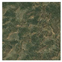 |
| Moderate desertification | 10%~30% | Wind erosion activity is frequent. The dunes are striped or irregular patches, interspersed with sparse vegetation, and the images presents reddish-brown and green colors. |  |
| Severe desertification | <10% | Wind erosion activity is violent. The dune presents clear morphological characteristics and an obvious wavy pattern. The image presents bright reddish-brown or even white colors. There is almost no vegetation. | 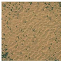 |
| Variable Categories | Variable Name | Description of Features |
|---|---|---|
| Spectral characteristics | Band Mean | Brightness values for Landsat 8 OLI band 1–7 |
| Band Standard Deviation | Spectral standard deviation of Landsat 8 OLI band 1–7 | |
| Geometric features | Area | The number of pixels that compose the image objects |
| Shape Index | The ratio of the boundary length of the image to the square root of four times the area | |
| Compactness | The ratio of the perimeter of an object to the square root of its area | |
| Roundness | The ratio of the perimeter of the object to the perimeter of the minimum outer rectangle | |
| Thematic indices | NDVI | |
| Albedo | ||
| GSI | ||
| Fe2O3 |
| Types of Desertification | Non | Mild | Moderate | Severe | PA (%) | UA (%) |
|---|---|---|---|---|---|---|
| Non | 4436 | 13 | 33 | 4 | 83.13 | 98.89 |
| Mild | 632 | 4861 | 1693 | 0 | 83.25 | 67.65 |
| Moderate | 247 | 963 | 9209 | 1123 | 82.14 | 79.79 |
| Severe | 21 | 2 | 276 | 6328 | 84.88 | 95.49 |
| OA (%) | 83.22 | |||||
| Kappa coefficient | 0.7686 | |||||
| Types of Desertification | Non | Mild | Moderate | Severe | PA (%) | UA (%) |
|---|---|---|---|---|---|---|
| Non | 4877 | 103 | 0 | 4 | 91.40 | 97.85 |
| Mild | 189 | 5453 | 923 | 0 | 93.39 | 83.06 |
| Moderate | 270 | 283 | 10,131 | 672 | 90.37 | 89.21 |
| Severe | 0 | 0 | 157 | 6779 | 90.93 | 97.74 |
| OA (%) | 91.28 | |||||
| Kappa coefficient | 0.8800 | |||||
| Year | Type | Non | Mild | Moderate | Severe | Other |
|---|---|---|---|---|---|---|
| 2001 | Area (km2) | 2683.38 | 7284.62 | 11,543.73 | 8082.01 | 899.36 |
| Percent (%) | 8.80 | 23.89 | 37.86 | 26.50 | 2.95 | |
| 2006 | Area (km2) | 2174.90 | 7761.82 | 12,895.72 | 6865.10 | 795.57 |
| Percent (%) | 7.13 | 25.45 | 42.29 | 22.52 | 2.61 | |
| 2011 | Area (km2) | 1800.03 | 8103.14 | 14,437.98 | 5295.36 | 856.59 |
| Percent (%) | 5.90 | 26.57 | 47.35 | 17.37 | 2.81 | |
| 2016 | Area (km2) | 3353.87 | 8628.09 | 13,161.23 | 4516.51 | 833.40 |
| Percent (%) | 11.00 | 28.30 | 43.16 | 14.81 | 2.73 | |
| 2021 | Area (km2) | 3466.31 | 9823.17 | 12,533.98 | 3966.09 | 703.54 |
| Percent (%) | 11.37 | 32.21 | 41.10 | 13.01 | 2.31 |
| Year | Type | Severe Degradation | Degradation | Stability | Restoration | Significant Restoration |
|---|---|---|---|---|---|---|
| 2001–2006 | Area (km2) | 1071.09 | 4160.34 | 19,162.86 | 4993.73 | 1105.08 |
| Percent (%) | 3.51 | 13.64 | 62.85 | 16.38 | 3.62 | |
| 2006–2011 | Area (km2) | 620.25 | 3821.00 | 20,797.95 | 4278.67 | 975.23 |
| Percent (%) | 2.03 | 12.53 | 68.21 | 14.03 | 3.2 | |
| 2011–2016 | Area (km2) | 628.79 | 3170.64 | 19,757.32 | 5153.35 | 1783.00 |
| Percent (%) | 2.06 | 10.4 | 64.79 | 16.9 | 5.85 | |
| 2016–2021 | Area (km2) | 1175.37 | 4545.94 | 17,841.65 | 5258.28 | 1671.87 |
| Percent (%) | 3.86 | 14.91 | 58.51 | 17.24 | 5.48 |
Disclaimer/Publisher’s Note: The statements, opinions and data contained in all publications are solely those of the individual author(s) and contributor(s) and not of MDPI and/or the editor(s). MDPI and/or the editor(s) disclaim responsibility for any injury to people or property resulting from any ideas, methods, instructions or products referred to in the content. |
© 2023 by the authors. Licensee MDPI, Basel, Switzerland. This article is an open access article distributed under the terms and conditions of the Creative Commons Attribution (CC BY) license (https://creativecommons.org/licenses/by/4.0/).
Share and Cite
Han, J.; Han, L.; Sun, G.; Mu, H.; Zhang, Z.; Wang, X.; Wang, S. Optimal Scale Selection and an Object-Oriented Method Used for Measuring and Monitoring the Extent of Land Desertification. Sustainability 2023, 15, 5619. https://doi.org/10.3390/su15075619
Han J, Han L, Sun G, Mu H, Zhang Z, Wang X, Wang S. Optimal Scale Selection and an Object-Oriented Method Used for Measuring and Monitoring the Extent of Land Desertification. Sustainability. 2023; 15(7):5619. https://doi.org/10.3390/su15075619
Chicago/Turabian StyleHan, Junliang, Liusheng Han, Guangwei Sun, Haoxiang Mu, Zhiyi Zhang, Xiangyu Wang, and Shengshuai Wang. 2023. "Optimal Scale Selection and an Object-Oriented Method Used for Measuring and Monitoring the Extent of Land Desertification" Sustainability 15, no. 7: 5619. https://doi.org/10.3390/su15075619
APA StyleHan, J., Han, L., Sun, G., Mu, H., Zhang, Z., Wang, X., & Wang, S. (2023). Optimal Scale Selection and an Object-Oriented Method Used for Measuring and Monitoring the Extent of Land Desertification. Sustainability, 15(7), 5619. https://doi.org/10.3390/su15075619


