Abstract
Risk-Sensitive Land-Use Planning (RSLUP) is a critical process for integrating disaster-risk management (DRM) considerations into land-use planning, for which first it is necessary to understand the existing risk sensitivity. This study aims to develop a GIS-based multi-criteria zoning approach to mapping earthquake-risk sensitivity of land use at local level. The methodology comprises two main steps. Firstly, the spatial earthquake-risk sensitivity of land use is evaluated based on some risk themes related to development, land use, and emergency facilities. Secondly, earthquake-risk sensitivity is mapped by overlaying the spatial risk-theme maps, using weights determined through the Analytical Hierarchical Process (AHP). Overall, four earthquake-risk-sensitive zones were identified in the study area, ranging from high-risk-sensitive zones to low-risk-sensitive zones. This research contributes to the theory and practice of DRM by proposing a multi-criteria risk-sensitivity assessment and mapping methodology. The findings demonstrate that the risk-sensitivity map provides policymakers with a guide to identify “where” and “why” RSLUP interventions are necessary. This will serve as a decision-support system to formulate the “what” and “how” of the RSLUP at the local level, reflecting the risk sensitivity accordingly and thereby ensuring sustainability.
1. Introduction
Catastrophic earthquakes can affect large areas, with long-lasting economic, social, and political effects []. Such an effect is exaggerated in urban centers due to unplanned urbanization and development in high-risk zones []. This can be combated through proper risk-management measures, which have been proven effective from historical earthquakes in different countries [,,]. Among different approaches to achieving resilience against earthquakes, Risk-Sensitive Land-Use Planning (RSLUP) is significant, and is the process of mainstreaming disaster-risk reduction and management parameters in land-use planning []. It is an effective approach to ensure sustainable hazard mitigation and thereby to ensure resilience by reducing disaster losses (human life and physical, environmental, and institutional assets) [,,]. According to Saunders and Becker [], to achieve long-term sustainability and greater resilience, visionary land-use-planning solutions are necessary. Such planning is much more effective at the local level because it ensures micro-level risk management [].
According to Villacis [], for appropriate disaster-risk management, appropriate urban and regional planning strategies and their effective implementation is a must. However, the sustainability of planning appropriate strategies requires identifying and understanding the existing risk as well as the underlying reasons for such risks, along with their magnitude [,]. Hence, to ensure the successful application of RSLUP, it is necessary to understand the risk sensitivity of the existing land use through prior assessment [,,]. Based on the findings from the assessment, a risk-sensitivity zoning map can be produced, from which the existing spatial risk sensitivity of the land use of an area can be observed promptly [,,]. Based on the findings from the risk-sensitivity assessment of the land use and the risk-sensitivity zoning map, RSLUP can be carried out. This would ensure the appropriate adoption of strategies in the land-use planning, reflecting the existing risk sensitivity accordingly. Thus, the plan would be more effective and sustainable [,], contributing to the resilience of the built environment in the long run by addressing the existing risk sensitivity.
Although a large and growing body of literature has investigated RSLUP, the research to date has tended to focus on RSLUP approaches [,,], the effectiveness of integrating risk sensitivity into urban master plans to limit future development in disaster-prone areas [,], the integration of earthquake hazards into land-use plans and policy statements at the national level [,], the integration of earthquake-risk sensitivity in land-use planning at the city level [,,], and the implementation of RSLUP through policy initiatives by local, federal, and state governments [,].
Realizing the importance, several studies have focused on RSLUP at the local level. Sharma, Donovan, Krishnamurthy and Creed [] explored the scope of public participation in RSLUP at the local level in Nepal. Barua, et al. [] proposed a methodology to integrate earthquake-risk sensitivity into land-use planning for a local-level area in Bangladesh. Motamed, et al. [] presented a model to find an optimal spatial land-use allocation pattern for a defined urban environment to assist the urban planners with a hazard-informed land-use allocation in planning new urban settlements or in improving existing urban areas in Iran. Bendimerad and von Einsiedel [] intended to reduce earthquake risk of a highly vulnerable urban area in the Philippines by means of urban redevelopment through RSLUP. Fat-Helbary, et al. [] studied earthquake-risk sensitivity of a proposed city area in Egypt and anticipated some land-use-planning strategies to integrate risk sensitivity into the proposed plan. Several local-level projects were undertaken in Istanbul for RSLUP, e.g., the Zeytinburnu urban-transformation project for redevelopment and the Marmara Earthquake Emergency Reconstruction (MEER) project []. However, none of them emphasized the importance or application of assessment and mapping of existing land use at the local level to facilitate effective and sustainable local-level RSLUP. Aggregating different aspects to obtain an overall picture of the risk sensitivity was also not considered.
In this background, this research aims to introduce a GIS-based multi-criteria zoning approach for the assessment and mapping of spatial earthquake-risk sensitivity of the land use of a local-level area to fill one of the gaps in RSLUP, particularly at the local level. Thus, the objectives of this research are twofold: firstly, to assess spatial earthquake-risk sensitivity of a land use at the local level, and secondly, to prepare a multi-criteria risk-sensitivity zoning map for the area combining the assessed risk. Here, a local level area in Dhaka, Bangladesh, was considered as the case-study area.
2. Literature Review
2.1. Risk Themes for Earthquake-Risk-Sensitivity Assessment of the Land-Use Plan
Risk themes are distinctly manageable clusters of probabilities and vulnerabilities, which are required to be considered for RSLUP []. Therefore, relevant risk themes should be considered a basis for earthquake-risk-sensitivity assessment of the land-use plan. The World Bank and Earthquakes and Megacities Initiative (EMI) [] (p. 42) proposed some risk themes and their corresponding risk factors in the Risk-Sensitive Land-Use Planning Guidebook for Dhaka city under the Bangladesh Urban Earthquake Resilience Project. The risk themes are related to:
- Governance: planning process and plan formulation, legal environment and institutional arrangements, implementation process (development-permit process, building-code enforcement, zoning enforcement, etc.), risks in administrative incapacities (deficiencies in terms of infrastructure/hardware, experts, training programs, etc., of the municipalities and governorate), risks of alienation of citizens (avoidance of participation efforts and involvement);
- Development: risks in macro form and growth tendencies in the metropolitan area (hazard assessment and analyses of alternatives in settlement configuration), urban-fabric risks, as related to the location and nature of physical development (building height/proximity, plots, density, roads, carparks, etc.);
- Built environment: risks in the building stock, risks in lifelines;
- Land use: incompatible land-use risks of neighboring units (in buildings and adjacent land uses), risks of hazardous uses (liquefied petroleum-gas and petrol stations, chemicals, explosives, etc.), special risk areas/special buildings (areas subject to landslide/flooding/tsunami, etc., as well as historic buildings and their environs);
- Emergency facilities: risks in emergency facilities (locational, organizational, structural attributes of hospitals, schools, etc.), open-space-deficiency risks (open-space requirements of emergency access and storage and/or temporary shelters);
- Economic factor: risks of productivity loss (industrial plants, businesses, etc.);
- External factor: external vulnerabilities and risks (climatic extremes, accidents, public unrest, terrorism, etc.).
Although the World Bank and EMI [] provided a guideline for RSLUP, it does not propose a methodology for the assessment of earthquake-risk sensitivity of land-use plans based on these risk themes.
2.2. Ground Shaking
An earthquake with one magnitude at one epicenter produces a range of levels of ground shaking at sites throughout the region depending on the distance from the epicenter. It is represented in terms of Peak Ground Acceleration (PGA), which is the peak horizontal acceleration as a percentage of acceleration due to the force of gravity, or “g”. After the assessment of ground shaking due to an earthquake in an area, it is represented by a “ShakeMap”, which is a representation of ground-shaking distribution in an area produced by an earthquake []. There are several modeling tools available for the assessment of ground shaking, such as HAZUS (HAZards United States), GIS-based RADIUS (Risk-Assessment tools for DIagnosis of Urban areas against Seismic disasters), SELENA (SEismic Loss EstimatioN using a logic-tree approach), ShakeMap, and KHM (Karmania Hazard Model). Table 1 shows a comparison of them. Although the parameters are same for all the methods, differences in the detailing of the analysis leads to variation in the accuracy of the outputs.

Table 1.
Comparison among earthquake ground-shaking-assessment tools.
2.3. Ground Response or Soil Amplification
Ground shaking is the primary cause of earthquake damage to manmade structures. However, some places in the same area may experience stronger seismic shaking than others during such events. The main reason behind such phenomena is the complexities and variation in the rock and soil conditions. During an earthquake, the propagation of seismic waves through the soil columns alters the amplitude, frequency, and duration of ground shaking differently depending on the rock and soil conditions (in some places it is reduced, whereas in some places it is intensified). Such influence of the underlying rock and soil conditions on the local amplification of earthquake shaking is called the site effect. The analysis to determine the site effect is called the assessment of ground response or soil amplification []. There are several methods for evaluating the effect of local soil conditions on ground response during earthquakes. Some of the commonly used tools for analysis of ground response or soil amplification are SHAKE, DEEPSOIL, and PLAXIS. Table 2 shows a comparison of them.
Table 2.
Comparison of ground-response or soil-amplification tools.
2.4. Soil-Liquefaction Susceptibility
Soil liquefaction is when saturated sand and silt behave like a liquid during an earthquake, and it occurs mostly in regions of manmade landfill. Factors that influence liquefaction include the geologic history of the deposit, groundwater depth, grain-size distribution, soil density, and ground slope. During an earthquake, excess pore-water pressure develops due to ground shaking, which causes the soil to lose strength and stiffness. If the pore-water pressure builds up to the point where it is equal to the overburden pressure, the sand loses its strength completely and it develops a liquefied state. This can cause buildings to sink or tilt, lightweight structures to float upwards, and foundations to displace laterally. The physical characteristics of the soil determine liquefaction susceptibility, and there are four methods for evaluating the liquefaction potential of sandy soil due to earthquake motion [,,]. Table 3 shows a comparison of them. All of these methods produce reliable outcomes and are widely used. However, the choice of method depends on the complexity and usefulness, considering the scale.
Table 3.
Comparison among soil-liquefaction susceptibility-assessment methods.
2.5. Fuzzy Overlay
“Fuzzy overlay” is a raster-overlaying method that follows fuzzy logic. It is applicable in such cases where it may become necessary to overlay raster data with different scales and units and have inaccuracies in the attributes and geometry of spatial data. It specifically addresses situations in which the boundaries between classes are not clear []. The concept is rooted in set theory and pertains to the likelihood of a phenomenon being a member of a set or class, rather than probabilities [,]. Considering its applicability, several researchers utilized the fuzzy-overlay tool for raster-overlay analysis. It was used for hazard assessment for earthquakes [,], fire [], drought [], landslides [,], land subsidence [], and floods []. Some researchers have utilized fuzzy overlay for suitability analysis in the fields of port development and evaluation [], sustainable urban development [], and agriculture [,].
The fuzzy-overlay method involves two steps: (i) fuzzification and (ii) fuzzy overlay. Fuzzification is necessary to reclassify or transform the raster datasets to be overlaid on a 0 (no membership) to 1 (full membership) scale, identifying the possibility of belonging to a specified set [,]. In ArcGIS 10.3.1, it can be done using the Fuzzy Membership tool. To aid this transformation process, there are several membership functions in the Fuzzy Membership tool, i.e., fuzzy Gaussian, fuzzy large, fuzzy mean and standard-deviation-based large, fuzzy linear, fuzzy near, fuzzy small, and fuzzy mean and standard-deviation-based small []. The fuzzy-large approach is used when larger input values are more likely to be a member of the set. The midpoint is used to identify the crossover point, with values greater than the midpoint having a higher possibility of being a member of the set. This approach is consistent with soil-amplification and soil-liquefaction susceptibility. After fuzzification of the raster data, several techniques are available for fuzzy overlaying, including fuzzy and, fuzzy or, fuzzy product, fuzzy sum, and fuzzy gamma. Fuzzy or returns the maximum value of the sets the cell location belongs to, which is useful in seismic-hazard assessment to identify the highest membership values for any of the input criteria. If an area is susceptible to either criterion, it is considered vulnerable. []
3. Methodology
3.1. Selection of the Study Area and Study-Area Profile
Bangladesh has a high probability of earthquake occurrence due to its geographical location and historical trend of seismicity. The country is located in the northeastern part of the Indian sub-continent at the junction of three moving plates (i.e., the Indian plate, the Eurasian plate, and the Burmese micro-plate), which results in the generation of active faults []. According to Akhter [] (p. 402), “…The Indian plate is moving ~6 cm/yr in a north-east direction and subducting under the Eurasian (@45 mm/yr) and the Burmese (@35 mm/yr) plates in the north and east, respectively. This continuous motion is taken up by active faults…” Thus, the movement of the plates in and near Bangladesh are generating active faults. The five main active faults lying in and near Bangladesh are the Madhupur fault (MF), Dauki Fault (DF), Plate Boundary Fault-1 (PBF-1), Plate Boundary Fault-2 (PBF-2), and Plate Boundary Fault-3 (PBF-3) []. The map showing the regional tectonic setup of Bangladesh with respect to the plate configuration can be found in Akhter [] (p. 402), and the map showing the earthquake-fault zones in and near Bangladesh can be found in CDMP [] (p. 5-1).
Among other cities in the country, Dhaka, the capital city of Bangladesh, is at high risk for exposure to potential earthquakes, where the vulnerability is high due to unplanned land use without disaster-risk consideration and violation of building codes and by-laws [,]. Small tremors are felt in and around the country every year from time to time. However, in the past few hundred years, several catastrophic earthquakes have happened in Bangladesh, and Dhaka city was greatly affected. The most significant among them were the Cachar Earthquake of 1869 (from the PBF-3 fault at Modified Mercalli Intensity MMI VI in Dhaka city), the Bengal Earthquake of 1885 (from the Madhupur Fault at MMI VII+ in Dhaka city),the Great Indian Earthquake of 1897 (from the Dauki Fault at MMI VIII+ in Dhaka city), the Sri-Mangal Earthquake of 1918 (from the PBF-2 Fault at MMI VI+ in Dhaka city), and the Dhubri Earthquake of 1930 (from the Dhubri Fault at MMI V+ in Dhaka city) [,]. A powerful earthquake needs at least 100–150 years to originate for a particular region, and thus is overdue for Bangladesh, as it last experienced a large earthquake in 1897 []. Hence, the occurrences of historical earthquakes and long-term silences of a potential earthquake happening (seismic gap) across the region indicates that the active faults are gaining energy [,,]. Consequently, the possibility of a strong earthquake occurring and affecting Dhaka city is increasing over the time period. Therefore, different national and international studies have identified Dhaka as being highly vulnerable to earthquakes [,].
Considering the earthquake vulnerability of Dhaka city, several studies have been carried out focusing on earthquake-risk assessment and management [,,]. Barua, Islam and Ansary [] focused on the integration of earthquake-risk sensitivity in land-use planning. Several initiatives have been undertaken by the Government of the Republic of Bangladesh (GoB) to integrate risk sensitivity into the land-use-planning process [,,]. Nevertheless, none of the research focused on the assessment and mapping of earthquake-risk sensitivity of the land use at the local level before the RSLUP.
Uttara Residential Model Town (URMT) (3rd phase), Dhaka, Bangladesh, was selected as the study area in this research. It is one of the township projects initiated by the Capital Development Authority (RAJUK) []. It is located in the northern part of the Dhaka Metropolitan area, which has been identified as a highly earthquake-prone area []. Figure 1 shows a satellite image of the study area (URMT 3rd phase), along with its location in Dhaka city in the inset.
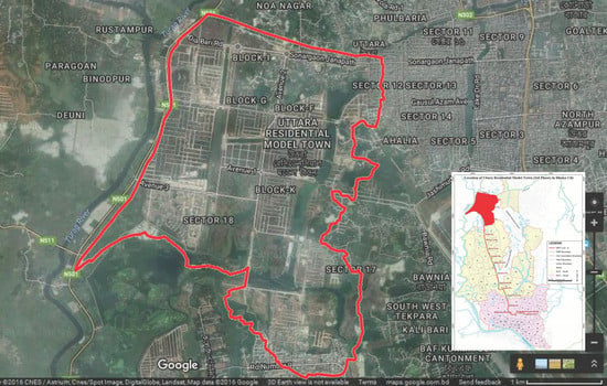
Figure 1.
Satellite image and location of the study area (URMT 3rd phase, Dhaka, Bangladesh). Source: Adapted from Google Satellite Image (2016) and RAJUK [].
The study area includes around 9.11 km2 of land. The proposed density of the study area is 300 persons per acre and the projected total population to be accommodated within its area is around 0.65 million people []. The area is divided into four sectors (i.e., 15–18) and a central plaza (commercial zone). The four sectors are further divided into 40 neighborhoods. The land use in the study area was planned considering the grid pattern. Here, different uses were allocated by RAJUK based on the Private Housing Land Development Rule, 2004 [], considering the projected population to ensure minimum land for urban community facilities and improve the living quality []. Among different uses, the most significant uses of the total area are road network (33.73%), residential (33.39%), and commercial (11.81%). The rest of the uses include hazardous uses, critical facilities (educational, health, and public service), utility services, water bodies, and open space. Figure 2 shows the land-use map of the study area.
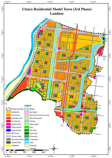
Figure 2.
Land-use map of the study area (reproduced with permission from Barua et al., “Integration of earthquake risk-sensitivity into land use planning: An approach for a local level area at development phase”, International Journal of Disaster Risk Reduction, published by Elsevier, 2020 []).
At the time of conducting this research (2016 to 2018), the study area was under a development process. About 92% of the site-development work was completed. About 70% of the road-construction work was completed. Electric poles were partially installed. Water-supply and gas-line installation works were yet to be started. The remaining works were in progress.
3.2. Data Collection and Processing
The necessary data required for this research were collected from secondary sources and key informant interviews from 2016 to 2018. A land-use map of the study area was collected from RAJUK [,]. Borehole-test data at 10 different points of the study area were collected from the Department of Civil Engineering, Bangladesh University of Engineering and Technology (BUET). The GIS shapefiles of the geomorphology and suitability of the structures considering the geomorphic unit of the Dhaka Metropolitan Area were collected from the Geological Survey of Bangladesh (GSB) []. From these collected resources, data from the study area were extracted for this research. All the spatial analysis and mapping in this research were done in the Arc GIS 10.3.1 platform. Therefore, to ensure consistency of scale, all of the collected maps and spatial data of the study area were converted into GIS shapefiles considering the Bangladesh Transverse Mercator (BTM) projection system.
3.3. Selection of Risk Themes for Assessment of Earthquake-Risk Sensitivity of the Land Use
Among the risk themes mentioned in Section 2.1, some themes were selected as the criteria for earthquake-risk-sensitivity assessment of the land use of the study area in this research considering the context of this research and the scale and development status of the study area. These are related to development, land use, and emergency facilities, including macro-form risks (seismic hazard), risks in transportation, risks in hazardous uses, special risk areas (geomorphic suitability and distance from a water body), open-space-scarcity risk, and risks in critical facilities (distance from potential temporary shelters and distance from health facilities).
3.4. Seismic-Hazard Assessment of the Study Area
Among the risk themes, macro-form risks include understanding and evaluating the earthquake hazard in an area to ensure increased resiliency through the successful adoption of appropriate measures in land-use planning [,,]. It helps to identify and avoid potential problems associated with development in hazard-prone areas [,]. In this research, for the assessment of earthquake hazard in the study area, first, the scenario earthquake was selected based on the study of the GoB on earthquake scenarios for Dhaka city under the Comprehensive Disaster Management Program (CDMP) []. The detailed discussion and findings from the scenario selection are discussed in Section 4.1. Based on the selected scenario earthquake, the earthquake hazard in the study area was assessed through assessment of ground shaking, ground response or soil amplification, and soil-liquefaction susceptibility. After that, the seismic-hazard map of the study area was prepared. The assessment steps and methods are discussed in the following sections:
3.4.1. Assessment of Ground Shaking
Among the different methods discussed in Section 2.2 (Table 1), GIS-based RADIUS is more convenient to use for its simple methodology and because it does not require detailed technical knowledge of earthquake engineering to ensure a medium–high level of accuracy []. Though it is not sufficient in terms of detailing, it is good enough for decision-making, considering the financial and temporal aspects []. Some studies in Bangladesh also utilized the RADIUS tool [,]. Therefore, to prepare the ground-shaking map of the study area in terms of PGA, the GIS-based RADIUS tool was used in this research. For this purpose, first, the study area was divided into square grids with a dimension of 0.25 km by 0.25 km using the Fishnet tool in ArcGIS 10.3.1 considering the dimension of the study area. After that, the grids were inputted into the RADIUS tool. Then, the parameters from the selected scenario earthquake were inputted, e.g., epicenter location, magnitude of the earthquake, fault-plane attributes (dimensions, depth to the top of the fault, orientation, and dip), and distance of the epicenter from the study area. After running the tool using the inputted data, a ShakeMap of the study area was produced. After that, the grid-wise values of ground shaking were inputted in ArcGIS 10.3.1. Thus, the spatial distribution of ground shaking in the study area was computed for the scenario earthquakes.
3.4.2. Assessment of Ground Response or Soil Amplification
Among the different methods discussed in Section 2.3 (Table 2), DEEPSOIL can simulate ground-motion propagation through deep soil deposits in cases of high seismic intensities at the rock base. Therefore, in this research, DEEPSOIL software was used to analyze the ground response and soil amplification of the study area by integrating it with GIS. To study the soil amplification, first, the borehole-test data (soil composition) and corresponding ground-shaking results (obtained from Section 3.4.1) were inputted into DEEPSOIL. After running the software, soil-amplification factors for each of the points were generated. Then, these data points of the soil-amplification factors were inputted into ArcGIS 10.3.1. Then, using the Kriging interpolation tool in ArcGIS 10.3.1, the data points were converted into two-dimensional plane data, which is the ground-response or soil-amplification map of the study area. Kriging interpolation is one of the most suitable methods for geological and geotechnical predictions in space, and is known as the optimal-interpolation method and is less arbitrary than others [,]. In this way, a soil-amplification map of the study area was prepared for this research.
3.4.3. Assessment of Soil-Liquefaction Susceptibility
Of different methods discussed in Section 2.4 (Table 3), the penetration-test method was utilized in this research due to its simplicity and usefulness for mapping liquefaction susceptibility in large areas [,]. Based on the evaluation of the borehole-test data, including groundwater level, soil composition and subsoil investigation (Standard Penetration Test SPT-N value), and corresponding ground-shaking results (obtained from Section 3.4.1), the soil-liquefaction susceptibility at each of the points was generated. Then, these data points were inputted into ArcGIS 10.3.1. Using the Kriging interpolation tool in ArcGIS 10.3.1, the data points were converted into two-dimensional plane data, producing the soil-liquefaction-susceptibility map of the study area.
3.4.4. Mapping the Seismic Hazard of the Study Area
In this research, the soil-amplification- and soil-liquefaction-susceptibility maps of the study area were developed based on the ground-shaking attributes developed in GIS-based RADIUS. Overlaying these maps, the seismic-hazard map was prepared for the study area in ArcGIS 10.3.1. Here, liquefaction susceptibility and soil amplification are different phenomena and are represented in different units. Moreover, it is very difficult to classify these phenomena into distinct classes, e.g., high, moderate, and low. Considering the consistency of assumptions with the characteristics of the soil-amplification and soil-liquefaction susceptibility, the fuzzy-overlay technique was applied here (discussed in Section 2.5). Reclassification of the raster maps was done through fuzzification by applying the fuzzy-large function of the Fuzzy Membership tool in ArcGIS 10.3.1. After that, the fuzzy-or function of the fuzzy-overlay tool was applied to overlay the reclassified raster maps of soil-amplification and soil-liquefaction susceptibility. Thus, the seismic-hazard map of the study area was prepared.
3.5. Preparation of Individual Risk-Theme-Based Risk-Sensitivity Maps
To translate the risk themes into the spatial aspect, the risk themes were further defined and classified into risk-sensitivity scales (1 to 5, where 1 represents low risk sensitivity and 5 represents high risk sensitivity) based on the review of different works of literature [,,,,]. Table 4 shows the risk themes, their corresponding attributes, and the risk-sensitivity scales for the preparation of individual risk-theme-based risk-sensitivity maps of the study area. Risk-sensitivity maps were created for the land use of the study area using ArcGIS 10.3.1 based on the conditions and scales defined in Table 4. The prepared seismic-hazard map was reclassified into five classes for macro-form risk, whereas the Create Buffer tool was utilized for distance-based risk themes and corresponding attributes such as risks in urban texture, hazardous uses, special risk areas, open-space-scarcity risk, and risks in critical facilities. Shapefiles of land use such as primary road, hazardous use, water body, open space, educational and public facility, and health facility were used for this purpose. The soil-suitability data of GSB was reclassified into five classes for special risk areas (geomorphic suitability) using the Raster Reclassification tool according to the GSB classification shown in Table 4 [].
Table 4.
Risk themes, corresponding attributes, and risk-sensitivity scales for the preparation of individual risk-theme-based risk-sensitivity maps.
3.6. Mapping Earthquake-Risk Sensitivity of Land-Use Plan
The prepared risk-theme-based risk-sensitivity maps needed to be aggregated to obtain a cumulative multi-criteria risk-sensitivity zoning map of the study area. For this purpose, first, the comparative weights of the risk themes were determined through the Analytical Hierarchical Process (AHP) []. In this regard, key informant interviews were carried out. First, a list of experts was developed considering the relevance of their expertise to this research, which was further verified by each interviewee. Thus, seven experts were interviewed to carry out the pairwise comparison of the attributes. The affiliations of the seven experts interviewed were:
- Director (Relief), Department of Disaster Management (DDM), the Government of the People’s Republic of Bangladesh (GoB);
- Professor, Department of Urban and Regional Planning, BUET, Bangladesh;
- Professor, Department of Civil Engineering, and Director, BUET-Japan Institute of Disaster Prevention and Urban Safety (BUET-JIDPUS), BUET, Bangladesh;
- Urban Planning Officer, Asian Disaster Preparedness Center (ADPC), Bangladesh;
- Executive Engineer (Civil), Capital Development Authority (RAJUK), Bangladesh;
- Project Director, Urban Resilience Project, Capital Development Authority (RAJUK), Bangladesh;
- Shelter specialist, Early Recovery Facility (ERF), United Nations Development Programme (UNDP), Bangladesh.
The face-to-face interviews were carried out from March 2018 to June 2018 by scheduling individual interview dates and places based on the expert’s permission and convenience. While interviewing the experts, the confidentiality of the interview was explained to them and their permission was duly requested. After that, the experts were informed about the purpose of this research and the procedure of the interview. Following that, the interviews were carried out. Here, responses with a Consistency Index (CI) less than or equal to 10% was considered a valid response.
Based on the comparative weights of different risk themes derived through the AHP method, the corresponding risk-theme-based risk-sensitivity maps were overlaid using the Weighted Overlay tool in ArcGIS 10.3.1. Finally, this overlaid map showed the spatial multi-criteria earthquake-risk-sensitivity zoning map of the land use of the study area.
4. Results and Discussion
4.1. Macro-Form Risk
Earthquake scenarios were selected based on a seismic-hazard-assessment study in Dhaka city carried out by OYO International Corporation (OIC) []. Table 5 shows the earthquake scenarios for Dhaka city. Among them, the first case was selected as the scenario earthquake for seismic-hazard assessment in the study area considering that the scenario would produce the highest-level ground motion in the city. Figure 3a shows the ground-shaking map of the study area for the selected scenario earthquake. From the map, it was visible that the northeastern portion of the study area is more prone to earthquake shaking.
Table 5.
Earthquake scenarios for Dhaka city.
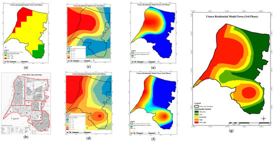
Figure 3.
Macro-form risk in the study area. (a) Ground shaking; (b) borehole-test locations; (c) soil amplification; (d) soil-liquefaction susceptibility; (e) fuzzy membership of the soil-amplification factor; (f) fuzzy membership of the soil-liquefaction susceptibility; (g) seismic-hazard map.
Based on the ground-shaking map (Figure 3a) and borehole-test data (Figure 3b), the soil-amplification factor (Figure 3c) and soil-liquefaction susceptibility (Figure 3d) in the study area were analyzed. To analyze the earthquake hazard in the study area, the maps were converted into the same base through fuzzy membership. Figure 3e,f show the fuzzy membership of the amplification factor and soil-liquefaction susceptibility in the study area, respectively. Figure 3g shows the seismic-hazard map of the study area that was developed by overlaying the fuzzy-membership maps of the amplification factor and soil-liquefaction susceptibility. Here a low earthquake hazard represents low-risk sensitivity and a high earthquake hazard represents high risk sensitivity from a macro-form risk perspective. Based on Figure 3, it was observed that the western portion of the study area is most prone to seismic hazard and therefore most sensitive to earthquake risk from a macro-form risk perspective.
4.2. Risks in Transportation
Risks in transportation were assessed based on the road network in the study area as means of escape and access to rescue and relief. According to the land-use plan of the study area, the roads are arranged in a grid pattern. The road width varies from 20 ft to 210 ft. From the analysis of the road network and its width, it can be said that the proposed road network ensures interconnectedness within the study area, which is suitable for emergency movement, rescue, and relief activities after an earthquake []. Along with roads for vehicular movement, there are interconnected lakes and walkways along them, which can also be utilized as an alternative to road transport.
The primary road network also reflects the connectedness of the study area with other parts of the city. This is crucial for receiving support from surrounding areas for response, rescue, and relief. Thus, areas nearer to the primary roads are less risk sensitive, and vice versa, from the perspective of risks in transportation. Figure 4b shows the risk sensitivity of the study area to the distance from primary roads, representing risks in transportation. From the Figure 4b, it was observed that a major portion of the study area is covered within 500 m of the primary roads, signifying lower risk sensitivity from the perspective of risks in transportation.
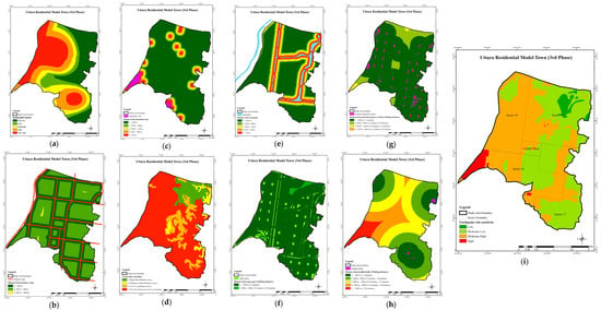
Figure 4.
Earthquake-risk sensitivity of the study area. (a) Seismic-hazard map; (b) risk sensitivity to the distance from primary roads; (c) risk sensitivity to the distance from hazardous uses; (d) risk sensitivity to geomorphic suitability; (e) risk sensitivity to the distance from a water body; (f) risk sensitivity to the distance from open space; (g) risk sensitivity to the distance from potential temporary shelter; (h) risk sensitivity to the distance from a health facility; (i) earthquake-risk-sensitivity zoning map.
4.3. Risks in Hazardous Uses
Risk in hazardous land uses in the study area was assessed based on proximity to hazardous uses. In the study area, hazardous land use comprises 2.25% of the total area. There are altogether nine proposed gas stations and petrol pumps, collectively six power substations, a Metro Rail Transit (MRT) depot, provision for a waste-management and recycling area in 0.13 square km of land, and a water-treatment plant with an area of 0.03 km2. The areas nearer to hazardous uses are highly sensitive to risks in hazardous uses due to the higher possibility of being affected by secondary hazards (e.g., fire, explosion, pollution, etc.). Figure 4c shows the risk sensitivity of the study area to the distance from hazardous uses.
4.4. Special Risk Areas
4.4.1. Geomorphic Suitability
The geomorphology of Dhaka city, including its geomorphologic composition and suitability for construction, were analyzed based on a geomorphologic composition by GSB []. From the geomorphological composition of the study area, it was observed that a major portion of the study area (about 67.1%) consists of the floodplain, marshy land and depression, and Madhupur terrace (low). Therefore, about 71.21% of the study area comprises very weak foundation conditions, for which a specialized foundation design is required; 17.58% is in a weak foundation condition, for which a pile foundation is required; and 11.21% is suitable for all kinds of infrastructure. Thus, grounded on the suitability for construction analyzed based on a geomorphologic composition by GSB, the weaker the soil condition, the higher the risk sensitivity due to the higher possibility of being affected by amplification and liquefaction. Figure 4d shows the risk sensitivity of the study area to the geomorphic suitability. Figure 4d shows that most of the area is highly risk sensitive, with very low geomorphic suitability for land development and built-environment construction.
4.4.2. Distance from a Water Body
From the analysis of water bodies in the land-use plan of the study area, it was observed that there are interconnected lakes proposed to be preserved by RAJUK comprising about 7.67% of the total study area. Here, the nearer the area is to a water body, the higher the risk sensitivity due to the higher possibility of being affected by liquefaction. Figure 4e shows the risk sensitivity of the study area to the distance from a water body, and the area close to the riverbanks are risk sensitive to development and construction.
4.5. Open-Space-Scarcity Risk
During and after an earthquake, the priority for evacuation spaces should be given to open areas. The land-use plan designates 7.69% of the study area as open spaces, including parks, playfields, graveyards, green belts, and other open areas. Playfields are evenly distributed near educational facilities, whereas parks are mainly located along lakes. The green belt is located on the southeastern side of Sector 18 to separate waste- and water-treatment plants from neighborhoods and the water-retention area. Open spaces are well connected by road networks and walkways, making them suitable for emergency response after an earthquake. The greater the distance from open spaces, the more sensitive the risk becomes because it takes more time to reach them for evacuation. In Figure 4f, the risk sensitivity of the study area to the distance from open spaces is shown. The figure indicates that the area is within 800 m of primary roads, indicating a lower risk sensitivity regarding proximity to open spaces.
4.6. Risks in Critical Facilities
4.6.1. Potential Temporary Shelters
Educational and religious facilities are suitable to be used for temporary shelter. The educational facilities proposed in the study area comprise 2.47% of the total area and include schools, educational institutions, and special institutions. There are three additional religious facilities. All of these facilities in the study area can be utilized as temporary shelter. The farther the area is from the potential temporary shelters, the higher the risk sensitivity due to the greater time needed to reach out for shelter after an earthquake. Figure 4g shows the risk sensitivity of the study area to the distance from potential temporary shelters.
4.6.2. Health Facilities
Health facilities are crucial to providing immediate treatment to injured people after an earthquake. The health facilities proposed in the study area include one hospital block and three health clubs, with a total area of 0.03 km2. Nevertheless, the health facilities are located in three corners of the study area, which may not be accessible by all residents of the study area after an earthquake. The farther the area is from the health facilities, the higher the risk sensitivity due to the greater time needed to reach out for treatment after an earthquake. Figure 4h shows the risk sensitivity of the study area to the distance from health facilities. Based on Figure 4h, it was observed that the southwestern part of the study area is most risk sensitive from the perspective of risks in health facilities.
4.7. Spatial Earthquake-Risk Sensitivity of Land Use
Table 6 shows the findings from the AHP, including the comparative weight and rank of the risk themes. From the analysis, it was observed that the highest preference was given to geomorphic suitability, distance from hazardous use, and distance from the health facility. The experts thought that the damage due to the earthquake would be greater if the soil condition is not considered during building construction. Moreover, hazardous uses will increase the risk of secondary hazards (fire, explosion, environmental pollution, etc.). Again, having few health facilities will cause the death of injured people due to a lack of emergency-treatment facilities.
Table 6.
Comparative weight and rank of the risk attributes through the AHP.
Figure 4i shows the multi-criteria earthquake-risk-sensitivity zoning map of the study area at the local level, depicting the spatial earthquake-risk sensitivity of the land-use plan. It was prepared by overlaying the risk-theme-based risk-sensitivity maps (Figure 4a–h) using the weights determined in Table 6 through the AHP method (as discussed in Section 3.6).
Overall, four earthquake-risk-sensitive zones were identified, ranging from high risk-sensitive zones (red zone) to low risk-sensitive zones (dark-green zone).
- The low earthquake-risk-sensitive zone is the relatively safest area. The area is in the northeastern part of the study area in sector 15. This zone is relatively less risk sensitive with respect to all individual risk themes (Figure 4).
- The moderate–low earthquake-risk-sensitive zone is a relatively safer area. The area is located mostly in the eastern part of the study area. Some parts of this zone are highly at risk from the perspective of geomorphic suitability. Otherwise, this zone is relatively less risk sensitive with respect to all other individual risk themes (Figure 4).
- The moderate–high earthquake-risk-sensitive zone is at lower risk than the red zone. The area is located mostly in the western part of the study area. This zone is highly at risk from the perspective of the seismic hazard, geomorphic suitability, distance from a water body, and distance from a health facility (Figure 4).
- The high earthquake-risk-sensitive zone is the highest-risk zone. The area is located in southwestern part of the study area in sector 18. This zone is at high risk due to the seismic hazard, distance from hazardous uses, geomorphic suitability, and distance from a health facility (Figure 4). All of these risk themes contribute to the high earthquake-risk sensitivity of this zone.
4.8. Discussion
From the above findings and analysis, it can be observed that the methodology proposed in this research led to the identification of different earthquake-risk-sensitive zones in a local-level area by aggregating different risks. This enables an understanding of where and why RSLUP interventions are necessary for the local-level area. Although few previous studies have focused on RSLUP at the local level, the approach proposed in this research to assess and map risk sensitivity to facilitate RSLUP is more effective than the previous approaches. Specifically, in the study by Barua, Islam and Ansary [], research was conducted in the same study area and a methodology was proposed to integrate earthquake RSLUP. The authors assessed the earthquake risk of the study area with respect to risk themes and suggested earthquake RSLUP strategies based on their findings. Although the proposed RSLUP strategies were detailed and appropriately addressed the risk-theme-based analysis, they were the same for the entire study area. However, our study identified that earthquake-risk sensitivity varies across different parts of the study area. In another study, Fat-Helbary, El Faragawy and Motaal [] proposed RSLUP strategies for a local area in Egypt based only on seismic-hazard assessment, which is applicable in raw-land situations. Other studies have proposed RSLUP strategies without analyzing and mapping the existing risk sensitivity of the land use [,].
Thus, the findings from applying the methodology proposed in this research will further facilitate the what and how of the RSLUP strategies as a decision-support system, reflecting the risk sensitivity accordingly and effectively and thereby fostering its sustainability [,]. Some examples of RSLUP strategies reflecting earthquake-risk-sensitivity zoning of the study area are:
- The low risk-sensitive zone is suitable for promoting growth. However, care should be taken to conserve the low-risk sensitivity of this zone, e.g., open-space, temporary-shelter, and health-facility conservation and maintenance.
- In the moderate–low earthquake-risk-sensitive zone, growth should be promoted by ensuring consideration of the soil condition and foundation requirements for construction. Conservation of the emergency facilities should be ensured.
- The moderate–high earthquake-risk-sensitive zone should be considered a moderate-alert zone. In this zone, development should be controlled with building-height restrictions. Here, construction should be carried out by considering soil conditions and foundation requirements. For risk transfer, mandatory building insurance can be promoted. Additional health facilities should be allocated to enhance coverage, along with conservation of the existing emergency facilities.
- The high earthquake-risk-sensitive zone should be considered a high-alert zone. Development control, construction safety, risk transfer, allocation of additional health facilities, and conservation of the emergency facilities should be more strictly applied. Additionally, the location of the hazardous uses in this zone can be reconsidered. Alternatively, more emphasis should be given on the safety of the hazardous uses, e.g., safe construction, safety measures, and buffer zone.
5. Conclusions
In conclusion, it can be said that the multi-criteria assessment and mapping of the risk sensitivity of the land use at the local level is of utmost importance. This will further pave the way for developing effective and sustainable RSLUP strategies reflecting the risk sensitivity accordingly and thereby increase the disaster resiliency of the area. This research brings out a methodology to assess the spatial earthquake-risk sensitivity of the land use at the local level and to prepare a multi-criteria risk-sensitivity zoning map. From the spatial earthquake-risk-sensitivity assessment of the land-use plan of the study area, positive features can be observed in the case of risks in urban texture and open-space-scarcity risk. The proposed grid-patterned road network and width ensure interconnectedness within the study area for emergency movement facilitating means of escape and access to rescue and relief after an earthquake. The open spaces are evenly located and well connected, which are effective and sufficient to serve the area in the time of emergency after an earthquake. However, major earthquake risks in the study area lie in macro-form risks, risks in hazardous uses, special risk areas, and risks in critical facilities. The study area is highly earthquake-hazard prone. The geomorphic condition increases the risk sensitivity of land use in the study area. There is no health facility in the southwestern side of the study area. From the multi-criteria risk-sensitivity zoning map of the study area, overall, four earthquake-risk-sensitive zones were identified, ranging from high risk-sensitive zones to low risk-sensitive zones. Sector 18 is more risk sensitive, but sector 16 is also highly earthquake-hazard prone. Thus, risk factors related to land use resulted in the increased risk sensitivity of sector 18 in the study area.
This research contributes to the theory of disaster-risk reduction and management by bringing out the importance of assessing and mapping the multi-criteria risk sensitivity of the land use of a local-level area and a methodology to do so. This research will contribute to practices by enabling the application of the methodology as a decision-support system for RSLUP. Thus, this method can be mainstreamed and institutionalized in planning policies and practices. It will enable policymakers to understand where and why RSLUP interventions are necessary for land use at the local level. The findings regarding applying this methodology will further guide the what and how of the RSLUP measures. This will further foster the sustainability of the RSLUP by reflecting the risk sensitivity accordingly and effectively. Consequently, this will lead to the development of a resilient and sustainable built environment.
The local-level analysis brings out a detailed and actual scenario of risk sensitivity more accurately, which will foster RSLUP strategies with more relevance and effectiveness. While doing so, the development status of an area should be considered because flexibility of the corrective RSLUP measures will depend on it. As such, drastic changes in land use may not be possible to accommodate in developed areas, areas under development may have some flexibility, and areas in the planning stage may have the most flexibility. This research can be replicated in other areas of Bangladesh, as well as in other countries, with necessary modifications considering local perspectives, development status, and hazard scenarios.
This research has some limitations, and there is scope for further research in these areas:
- (a)
- In this research, the study area considered was in the development phase. Due to the development status, some relevant development and built-environment-related risk themes could not be considered. Thus, the consideration of risk themes varies with the development status of the study area. Therefore, further research should be carried out for risk-sensitivity assessment and mapping of areas at other levels of development. While doing so, relevant risk themes and attributes should be considered based on the development status of the areas.
- (b)
- In this research, a risk-sensitivity assessment and mapping method is proposed for earthquakes. However, the context changes with the hazards. Moreover, an area may be at risk of numerous hazards (simultaneously or not). Therefore, in future research, a risk-sensitivity assessment and mapping method considering multiple hazards should be developed to enable the development of multi-hazard RSLUP.
- (c)
- Even though this research encourages local-level risk-sensitivity assessment, mapping, and RSLUP, a holistic approach also needs to be introduced and adopted by accumulating the local level findings and initiatives at the city, regional, and national levels to ensure cohesion among them. While doing so, additional appropriate risk themes should be considered (e.g., governance, economic factors, external factors, etc.).
- (d)
- Further research should be carried out to propose a methodology for RSLUP based on the application of the proposed methodology in this research (risk sensitivity and zoning map). While doing so, the scale and development status of the study area should be considered to define the scope for integrating RSLUP. This will lead to more realistic and thereby sustainable RSLUP.
Author Contributions
Conceptualization, U.B., M.A.A. and I.I.; data curation, U.B.; formal analysis, U.B. and H.S.M.; funding acquisition, U.B., M.A.A. and I.I.; investigation, U.B. and H.S.M.; methodology, U.B., M.A.A. and I.I.; project administration, M.A.A. and I.I.; resources, U.B., M.A.A. and I.I.; software, U.B. and M.A.A.; supervision, M.A.A., I.I. and M.M.; validation, M.A.A., I.I. and M.M.; visualization, U.B. and H.S.M.; writing—original draft, U.B., M.A.A. and I.I.; Writing—review and editing, U.B., H.S.M. and M.M. All authors have read and agreed to the published version of the manuscript.
Funding
This work was funded and supported by the Bangladesh University of Engineering and Technology (BUET), Dhaka, Bangladesh.
Institutional Review Board Statement
All the key informants gave their informed consent for inclusion before they participated in the study. The study was approved by the Committee for Advanced Studies and Research (CASR) of Bangladesh University of Engineering and Technology (BUET), Dhaka, Bangladesh, on 18 January 2017.
Informed Consent Statement
Informed consent was obtained from all subjects involved in the study.
Data Availability Statement
Data are available from the first author and can be shared with anyone upon reasonable request.
Conflicts of Interest
The authors declare no conflict of interest.
References
- Subedi, S.; Chhetri, M.B.P. Impacts of the 2015 Gorkha earthquake: Lessons learnt from Nepal. In Earthquakes-Impact, Community Vulnerability and Resilience; Santos-Reyes, J., Ed.; IntechOpen: London, UK, 2019; pp. 55–70. [Google Scholar]
- Ashraf, A. Risk modeling of soil erosion under different land use and rainfall conditions in Soan river basin, sub-Himalayan region and mitigation options. Model. Earth Syst. Environ. 2020, 6, 417–428. [Google Scholar] [CrossRef]
- WBI. The Great East Japan Earthquake: Learning from Mega Disasters: Knowledge Notes. Available online: http://wbi.worldbank.org/wbi/megadisasters (accessed on 2 October 2016).
- Bapat, A. Re-Orientation of Disaster Management Plans in Asian Countries in View of Recent Earthquakes in China, Haiti and Chile. Asian Disaster Manag. News 2010, 16, 20–21. [Google Scholar]
- Wayman, E. Chile’s Quake Larger But Less Destructive than Haiti’s; Earth: The Science behind the Headline; American Geosciences Institute: Alexandria, VA, USA, 2010; Available online: http://www.earthmagazine.org/article/chiles-quake-larger-less-destructive-haitis (accessed on 31 May 2017).
- Sudmeier-Rieux, K.; Paleo, U.F.; Garschagen, M.; Estrella, M.; Renaud, F.G.; Jaboyedoff, M. Opportunities, incentives and challenges to risk sensitive land use planning: Lessons from Nepal, Spain and Vietnam. Int. J. Disaster Risk Reduct. 2015, 14, 205–224. [Google Scholar] [CrossRef]
- Becker, J.S.; Beban, J.; Saunders, W.S.A.; Van Dissen, R.; King, A. Land use planning and policy for earthquakes in the Wellington Region, New Zealand (2001–2011). Australas. J. Disaster Trauma Stud. 2013, 2013, 3–17. [Google Scholar]
- Hada, C.L.; Shaw, R.; Pokhrel, A. Preparation and Adoption of Risk Sensitive Land Use Plans in the New Federal Context of Nepal. In Integrated Research on Disaster Risks: Contributions from the IRDR Young Scientists Programme; Djalante, R., Bisri, M.B.F., Shaw, R., Eds.; Springer Cham: Berlin/Heidelberg, Germany, 2021; pp. 175–191. [Google Scholar]
- Hada, C.; Shaw, R. Integrating disaster and climate change in risk sensitive land use planning. In Handbook on Climate Change and Disasters; Shaw, R., Ed.; Edward Elgar Publishing: Cheltenham, UK, 2022; pp. 462–469. [Google Scholar]
- Saunders, W.S.A.; Becker, J.S. A discussion of resilience and sustainability: Land use planning recovery from the Canterbury earthquake sequence, New Zealand. Int. J. Disaster Risk Reduct. 2015, 14, 73–81. [Google Scholar] [CrossRef]
- Bendimerad, F.; von Einsiedel, N. Disaster Risk Reduction of Highly Vulnerable Urban Areas through Urban Re-Development Case Study of Barangay Rizal, Makati, Philippines. In Proceedings of the 9th Symposium on New Technologies for Urban Safety of Mega Cities in Asia, Kobe International Conference Center 6-9-1, Minatojima-Nakamachi, Japan, 13–14 October 2010. [Google Scholar]
- Villacis, C.A. RADIUS—An IDNDR Project on Urban Earthquake Risk Management. In Proceedings of the 12th World Conference on Earthquake Engineering, Auckland, New Zealand, 30 January–4 February 2000. [Google Scholar]
- Caparros-Midwood, D.; Barr, S.; Dawson, R. Spatial optimization of future urban development with regards to climate risk and sustainability objectives. Risk Anal. 2017, 37, 2164–2181. [Google Scholar] [CrossRef] [PubMed]
- Burby, R.J.; Deyle, R.E.; Godschalk, D.R.; Olshansky, R.B. Creating hazard resilient communities through land-use planning. Nat. Hazards Rev. 2000, 1, 99–106. [Google Scholar] [CrossRef]
- WBI. Risk Sensitive Land-Use Planning: Readings: Landuse Planning and Disaster Risk Reduction. In World Bank Institute Distant Learning: Natural Disaster Risk Management Program; World Bank Institute (WBI): Washington, WA, USA, 2006. [Google Scholar]
- Saunders, W.S.A.; Kilvington, M. Innovative land use planning for natural hazard risk reduction: A consequence-driven approach from New Zealand. Int. J. Disaster Risk Reduct. 2016, 18, 244–255. [Google Scholar] [CrossRef]
- EMI. Risk-Sensitive Land Use Plan Final Report Kathmandu Metropolitan City, Nepal; Earthquakes and Megacities Initiative (EMI): Quezon, Philippines, 2010. [Google Scholar]
- World Bank; EMI. Risk-Sensitive Land Use Planning Guidebook. In Bangladesh Urban Earthquake Resilience Project; Earthquakes and Megacities Initiative (EMI): Metro Manila, Philippines, 2014. [Google Scholar]
- UDD; ADPC. Guidelines for Mainstreaming Disaster Risk Reduction into Land Use Planning for Upazilas and Municipalities in Bangladesh; Urban Development Directorate (UDD), Ministry of Housing and Public Works, The Government of the People’s Republic of Bangladesh (GoB), and Asian Disaster Preparedness Center (ADPC): Dhaka, Bangladesh, 2013.
- Wang, J.J. Integrated model combined land-use planning and disaster management: The structure, context and contents. Disaster Prev. Manag. Int. J. 2012, 21, 110–123. [Google Scholar] [CrossRef]
- Sharma, A.; Donovan, K.; Krishnamurthy, S.; Creed, M. Exploring the Scope of Public Participation for Risk Sensitive Land Use Planning in Nepal: A Policy Review. Sustainability 2022, 14, 14137. [Google Scholar] [CrossRef]
- Kim, S.; Rowe, P.G. Are master plans effective in limiting development in China’s disaster-prone areas? Landsc. Urban Plan. 2013, 111, 79–90. [Google Scholar] [CrossRef]
- Kamat, R. Planning and managing earthquake and flood prone towns. Stoch. Environ. Res. Risk Assess. 2015, 29, 527–545. [Google Scholar] [CrossRef]
- Erdik, M.; Durukal, E. Earthquake risk and its mitigation in Istanbul. Nat. Hazards 2008, 44, 181–197. [Google Scholar] [CrossRef]
- Hung, H.C.; Ho, M.C.; Chen, Y.J.; Chian, C.Y.; Chen, S.Y. Integrating long-term seismic risk changes into improving emergency response and land-use planning: A case study for the Hsinchu City, Taiwan. Nat. Hazards 2013, 69, 491–508. [Google Scholar] [CrossRef]
- Motamed, H.; Ghafory-Ashtiany, M.; Amini-Hosseini, K.; Mansouri, B.; Khazai, B. Earthquake risk–sensitive model for urban land use planning. Nat. Hazards 2020, 103, 87–102. [Google Scholar] [CrossRef]
- Hudson, B. Reconstituting land-use federalism to address transitory and perpetual disasters: The bimodal federalism framework. Brigh. Young Univ. Law Rev. 2011, 2011, 1991–2062. [Google Scholar]
- Barua, U.; Islam, I.; Ansary, M.A. Integration of earthquake risk-sensitivity into landuse planning: An approach for a local level area at development phase. Int. J. Disaster Risk Reduct. 2020, 50, 101836. [Google Scholar] [CrossRef]
- Motamed, H.; Ghafory-Ashtiany, M.; Amini-Hosseini, K. An Earthquake Risk–Sensitive Model for Spatial Land-Use Allocation. In Proceedings of the 15th World Conference on Earthquake Engineering, Lisboa, Portugal, 24–28 September 2012. [Google Scholar]
- Fat-Helbary, R.E.; El Faragawy, K.O.; Motaal, A.N.M.A. Land use planning and seismic hazards of the proposed Aswan New City area, Egypt. Acta Geodyn. Geomater. 2004, 1, 99–106. [Google Scholar]
- WBI. Risk Sensitive Land-Use Planning: Readings: Rise in Urban Vulnerabilities and Risks. In World Bank Institute Distant Learning: Natural Disaster Risk Management Program; World Bank Institute (WBI): Washington, WA, USA, 2006. [Google Scholar]
- USGS. ShakeMap Scientific Background. In Earthquake Hazards Program; USGS: Leiston, VA, USA, 2011. Available online: http://earthquake.usgs.gov/earthquakes/shakemap/background.php (accessed on 8 August 2016).
- FEMA. HAZUS®MH MR4 Earthquake Model Technical Manual; Department of Homeland Security, Federal Emergency Management Agency (FEMA), Mitigation Division: Washington (DC), WA, USA, 2014.
- RADIUS. Risk Assessment Tools for Diagnosis of Urban Areas Against Seismic Disasters, Launched by IDNDR, United Nations. Available online: http://www.geohaz.org/projects/radius.html (accessed on 2 October 2016).
- NORSAR; ICG. SELENA—Seismic Loss Computation Engine. Available online: http://selena.sourceforge.net/selena.shtml (accessed on 8 August 2016).
- Wald, D.J.; Worden, B.C.; Quitoriano, V.; Pankow, K.L. ShakeMap Manual: Technical Manual, User’s Guide, and Software Guide. In Techniques and Methods; USGS: Leiston, VA, USA, 2005; pp. 2328–7055. [Google Scholar]
- KDMC. Karmania Hazard Model User Manual; Kerman Disaster Management Center (KDMC): Kerman, Iran, 2008. [Google Scholar]
- Hassanzadeh, R.; Nedović-Budić, Z.; Razavi, A.A.; Norouzzadeh, M.; Hodhodkian, H. Interactive approach for GIS-based earthquake scenario development and resource estimation (Karmania hazard model). Comput. Geosci. 2013, 51, 324–338. [Google Scholar] [CrossRef]
- Guragain, R.; Jimee, G.; Dixit, A.M. Earthquake awareness and effective planning through participatory risk assessment: An experience from Nepal. In Proceedings of the 14th World Conference on Earthquake Engineering (14WCEE), Beijing, China, 12–17 October 2008; pp. 12–17. [Google Scholar]
- USGS. Soil Type and Shaking Hazard in the San Francisco Bay Area. In Earthquake Hazards Program; USGS: Leiston, VA, USA, 2016. Available online: http://earthquake.usgs.gov/regional/nca/soiltype/ (accessed on 5 September 2016).
- Wald, D.J.; Worden, B.C.; Quitoriano, V.; Pankow, K.L. ShakeMap® manual. In Technical Manual, Users Guide, and Software Guide Version; United States Geological Survey (USGS): Reston, VA, USA, 2006. [Google Scholar]
- Hashash, Y.M.A.; Groholski, D.R.; Phillips, C.A.; Park, D.; Musgrove, M. Deepsoil v4.0: User Manual and Tutorial; Univ. of Illinois: Urbana, IL, USA, 2011. [Google Scholar]
- Brinkgreve, R.B.J. Plaxis: Finite Element Code for Soil and Rock Analyses: 2D-Version 8: [User’s Guide]; Balkema: Rotterdam, The Netherlands, 2002. [Google Scholar]
- Brinkgreve, R.B.J.; Engin, E.; Swolfs, W.M.; Waterman, D.; Chesaru, A.; Bonnier, P.G.; Galavi, V. PLAXIS 3D 2011; Delft University of Technology & Plaxis BV: Delft, Netherlands, 2011. [Google Scholar]
- USGS. Liquefaction Susceptibility. In Earthquake Hazards Program; USGS: Leiston, VA, USA, 2016. Available online: http://earthquake.usgs.gov/regional/nca/bayarea/liquefaction.php (accessed on 8 August 2016).
- Sonmez, H. Modification of the liquefaction potential index and liquefaction susceptibility mapping for a liquefaction-prone area (Inegol, Turkey). Environ. Geol. 2003, 44, 862–871. [Google Scholar] [CrossRef]
- Marto, A.; Tan, C.S. Short review on liquefaction susceptibility. Int. J. Eng. Res. Appl. 2012, 2, 2115–2119. [Google Scholar]
- Lee, S.; Choi, U. Development of GIS-based geological hazard information system and its application for landslide analysis in Korea. Geosci. J. 2003, 7, 243–252. [Google Scholar] [CrossRef]
- Allen, T.I.; Wald, D.J. On the use of high-resolution topographic data as a proxy for seismic site conditions (VS30). Bull. Seismol. Soc. Am. 2009, 99, 935–943. [Google Scholar] [CrossRef]
- Cetin, K.O.; Seed, R.B.; Der Kiureghian, A.; Tokimatsu, K.; Harder, L.F., Jr.; Kayen, R.E.; Moss, R.E.S. Standard penetration test-based probabilistic and deterministic assessment of seismic soil liquefaction potential. J. Geotech. Geoenvironment. Eng. 2004, 130, 1314–1340. [Google Scholar] [CrossRef]
- Seed, H.B.; Idriss, I.M. Simplified procedure for evaluating soil liquefaction potential. J. Soil Mech. Found. Div. 1971, 97, 1249–1273. [Google Scholar] [CrossRef]
- Robertson, P.K.; Woeller, D.J.; Finn, W.D.L. Seismic cone penetration test for evaluating liquefaction potential under cyclic loading. Can. Geotech. J. 1992, 29, 686–695. [Google Scholar] [CrossRef]
- Robertson, P.K.; Wride, C.E. Evaluating cyclic liquefaction potential using the cone penetration test. Can. Geotech. J. 1998, 35, 442–459. [Google Scholar] [CrossRef]
- Stokoe, K.H.; Roberts, J.N., II; Hwang, S.; Cox, B.; Menq, F.Y.; Van Ballegooy, S. Effectiveness of inhibiting liquefaction triggering by shallow ground improvement methods: Initial field shaking trials with T-Rex at one site in Christchurch, New Zealand. In Soil Liquefaction during Recent Large-Scale Earthquakes; Orense, R.P., Towhata, I., Chouw, N., Eds.; Taylor and Francis Group: London, UK, 2014; pp. 193–202. [Google Scholar]
- Tang, L.; Zhang, X.; Ling, X.; Su, L.; Liu, C. Response of a pile group behind quay wall to liquefaction-induced lateral spreading: A shake-table investigation. Earthq. Eng. Eng. Vib. 2014, 13, 741–749. [Google Scholar] [CrossRef]
- ESRI. Applying Fuzzy Logic to Overlay Rasters; Environmental Systems Research Institute (ESRI), Inc. Available online: https://desktop.arcgis.com/en/arcmap/latest/tools/spatial-analyst-toolbox/applying-fuzzy-logic-to-overlay-rasters.htm (accessed on 20 December 2016).
- Mesgari, M.; Pirmoradi, A.; Fallahi, G. Implementation of Overlay Function Based on Fuzzy Logic in Spatial Decision Support System. World Appl. Sci. J. 2008, 3, 60–65. [Google Scholar]
- Rakuasa, H.; Supriatna, S.; Karsidi, A.; Rifai, A.; Tambunan, M. Spatial Dynamics Model of Earthquake Prone Area in Ambon City. In IOP Conference Series: Earth and Environmental Science; IOP Publishing: Bristol, UK, 2022; p. 012057. [Google Scholar]
- Ghaderi, R.; Farahmand, G. Zoning the Vulnerability of Urban Areas to Earthquake: The Case Study of Urmia City. Town Ctry. Plan. 2022, 14, 543–569. [Google Scholar]
- Rai, K.; Mishra, N.; Mishra, S. Forest Fire Risk Zonation Mapping using Fuzzy Overlay Analysis of Nainital District. In Proceedings of the International Mobile and Embedded Technology Conference (MECON), Noida, India, 10–11 March 2022; IEEE: Piscataway, NJ, USA, 2022; pp. 522–526. [Google Scholar]
- Elusma, M.; Tung, C.-P.; Lee, C.-C. Agricultural drought risk assessment in the Caribbean region: The case of Haiti. Int. J. Disaster Risk Reduct. 2022, 83, 103414. [Google Scholar] [CrossRef]
- Kirschbaum, D.; Stanley, T.; Yatheendradas, S. Modeling landslide susceptibility over large regions with fuzzy overlay. Landslides 2016, 13, 485–496. [Google Scholar] [CrossRef]
- Sharma, L.; Patel, N.; Ghose, M.; Debnath, P. Synergistic application of fuzzy logic and geo-informatics for landslide vulnerability zonation—A case study in Sikkim Himalayas, India. Appl. Geomat. 2013, 5, 271–284. [Google Scholar] [CrossRef]
- Park, I.; Lee, J.; Saro, L. Ensemble of ground subsidence hazard maps using fuzzy logic. Open Geosci. 2014, 6, 207–218. [Google Scholar] [CrossRef]
- Ganji, K.; Gharechelou, S.; Ahmadi, A.; Johnson, B.A. Riverine flood vulnerability assessment and zoning using geospatial data and MCDA method in Aq’Qala. Int. J. Disaster Risk Reduct. 2022, 82, 103345. [Google Scholar] [CrossRef]
- Yang, S.; Pan, Y.; Zeng, S. Decision making framework based Fermatean fuzzy integrated weighted distance and TOPSIS for green low-carbon port evaluation. Eng. Appl. Artif. Intell. 2022, 114, 105048. [Google Scholar] [CrossRef]
- Foroozesh, F.; Monavari, S.M.; Salmanmahiny, A.; Robati, M.; Rahimi, R. Assessment of sustainable urban development based on a hybrid decision-making approach: Group fuzzy BWM, AHP, and TOPSIS–GIS. Sustain. Cities Soc. 2022, 76, 103402. [Google Scholar] [CrossRef]
- Haile, M.M.; Abebe, A.K. GIS and fuzzy logic integration in land suitability assessment for surface irrigation: The case of Guder watershed, Upper Blue Nile Basin, Ethiopia. Appl. Water Sci. 2022, 12, 240. [Google Scholar] [CrossRef]
- Arab, S.T.; Ahamed, T. Land Suitability Analysis for Potential Vineyards Extension in Afghanistan at Regional Scale Using Remote Sensing Datasets. Remote Sens. 2022, 14, 4450. [Google Scholar] [CrossRef]
- ESRI. How Fuzzy Membership Works; Environmental Systems Research Institute (ESRI), Inc. Available online: https://pro.arcgis.com/en/pro-app/latest/tool-reference/spatial-analyst/how-fuzzy-membership-works.htm#:~:text=Fuzzy%20Near&text=The%20function%20is%20defined%20by,reaches%200%2C%20defining%20no%20membership (accessed on 20 December 2016).
- ESRI. How Fuzzy Overlay Works; Environmental Systems Research Institute (ESRI), Inc. Available online: https://pro.arcgis.com/en/pro-app/2.8/tool-reference/spatial-analyst/how-fuzzy-overlay-works.htm (accessed on 20 December 2016).
- Akhter, S.H. Earthquakes of Dhaka. In Environment of Capital Dhaka—Plants Wildlife Gardens Parks Air Water and Earthquake. Asiatic Society of Bangladesh; Islam, A., Ed.; Asiatic Society of Bangladesh (2010): Dhaka, Bangladesh, 2010; pp. 401–426. [Google Scholar]
- CDMP. Risk Assessment of Dhaka, Chittagong and Sylhet City Corporation Area. In Comprehensive Disaster Management Programme (CDMP); Ministry of Food and Disaster Management, Government of the People’s Republic of Bangladesh, Phase 1: Dhaka, Bangladesh, 2009. [Google Scholar]
- Hasnat, M.M.; Hoque, M.S. Developing satellite towns: A solution to housing problem or creation of new problems. Int. J. Eng. Technol. 2016, 8, 50–56. [Google Scholar] [CrossRef]
- Oldham, R.D. Report on the Srimangal earthquake of 12th June 1897. Mem. Geol. Surv. India 1899, 29, 1–349. [Google Scholar]
- Sharfuddin, M. Evaluation of Seismic Hazards for Bangladesh; Department of Civil Engineering, Bangladesh University of Engineering and Technology (BUET): Dhaka, Bangladesh, 2001. [Google Scholar]
- CDMP. Vulnerability Assessment of Dhaka, Chittagong and Sylhet City Corporation Area. In Comprehensive Disaster Management Programme (CDMP); Ministry of Food and Disaster Management, Government of the People’s Republic of Bangladesh, Phase 1: Dhaka, Bangladesh, 2009. [Google Scholar]
- Roy, S. Probabilistic Prediction for Earthquake in Bangladesh: Just How Big Does the Earthquake Have to Be Next Years? Open J. Earthq. Res. 2014, 3, 7. [Google Scholar] [CrossRef]
- Kamal, A.S.M.M. Earthquake risk reduction approaches in Bangladesh. In Disaster Risk Reduction Approaches in Bangladesh; Shaw, R., Mallick, F.H., Islam, A., Eds. Springer Science & Business Media: Berlin/Heidelberg, Germany, 2013; pp. 103–131. [Google Scholar]
- Davidson, R.A.; Shah, H.C. An Urban Earthquake Disaster Risk Index; Report No. 121; The John A. Blume Earthquake Engineering Center, Stanford University: California, CA, USA, 1997. [Google Scholar]
- Rahman, N.; Ansary, M.A.; Islam, I. GIS based mapping of vulnerability to earthquake and fire hazard in Dhaka city, Bangladesh. Int. J. Disaster Risk Reduct. 2015, 13, 291–300. [Google Scholar] [CrossRef]
- Rahman, M.M.; Barua, U.; Khatun, F.; Islam, I.; Rafiq, R. Participatory Vulnerability Reduction (PVR): An urban community-based approach for earthquake management. Nat. Hazards 2018, 93, 1479–1505. [Google Scholar] [CrossRef]
- Mazumder, R.K.; Rana, S.; Salman, A.M. First level seismic risk assessment of old unreinforced masonry (URM) using fuzzy synthetic evaluation. J. Build. Eng. 2021, 44, 103162. [Google Scholar] [CrossRef]
- UDD. Mymensingh Strategic Development Plan (MSDP) 2011–2031; Urban Development Directorate (UDD), Ministry of Housing and Public Works, The Government of the People’s Republic of Bangladesh (GoB): Dhaka, Bangladesh, 2011.
- UDD; ADPC. Handbook of Risk Sensitive Landuse Planning for Upazillas and Municipalities in Bangladesh; Urban Development Directorate (UDD), Ministry of Housing and Public Works, The Government of the People’s Republic of Bangladesh (GoB) and Asian Disaster Preparedness Center (ADPC): Dhaka, Bangladesh, 2016.
- RAJUK. Capital Development Authority of Bangladesh. Available online: http://www.rajukdhaka.gov.bd/rajuk/webHome (accessed on 20 December 2016).
- EMI. Dhaka Profile and Earthquake Risk Atlas; Metro Manila, Philippines: World Bank and Earthquakes and Megacities Initiative (EMI), World Bank and Earthquakes and Megacities Initiative (EMI): Metro Manila, Philippines, 2014. [Google Scholar]
- Shamsuzzaman, M. A Comparative Analysis of Plot Housing Schemes and Multi-Storeyed Apartment Block Housing Schemes in Dhaka: Land Economisation and Urban Community Services in the Context of Post Private Housing Land Development Rule, 2004 Scenario of Bangladesh. J. Bangladesh Inst. Plan. 2014, 7, 9363. [Google Scholar]
- MoHPW GoB. Private Housing Project Land Development Rule’ 2004; Ministry of Housing and Public Works, the Government People’s Republic of Bangladesh (GoB): Dhaka, Bangladesh, 2004.
- RAJUK. Landuse map of Uttara Residential Model Town (3rd Phase); Capital Development Authority of Bangladesh (RAJUK), the Government of the People’s Republic of Bangladesh: Dhaka, Bangladesh, 2010.
- GSB. Geomorphology and Foundation Condition Suitability for Dhaka Metropolitan Area; Geological Survey Of Bangladesh (GSB), Ministry of Power, Energy and Mineral Resources, Government of the People’s Republic of Bangladesh (GoB): Dhaka, Bangladesh, 2016.
- Erdik, M. Urban Earthquake Risk. In Geohazards: ECI Symposium Series; Nadim, F., Pöttler, R., Einstein, H., Klapperich, H., Kramer, S., Eds.; Engineering Conferences International (ECI): New York, NY, USA, 2006; Volume 17. [Google Scholar]
- Çabuk, A. A proposal for a method to establish natural-hazard-based land-use planning: The Adapazarı case study. Turk. J. Earth Sci. 2001, 10, 143–152. [Google Scholar]
- Alam, M.N.; Tesfamariam, S.; Alam, M.S. GIS-based seismic damage estimation: Case study for the City of Kelowna, BC. Nat. Hazards Rev. 2012, 14, 66–78. [Google Scholar] [CrossRef]
- Ahmed, S.; Urmi, M.T.; Islam, M.R.; Alam, M.J.B.; Munna, M.G. Earthquake vulnerability assessment of roads at Sylhet city in Bangladesh. Asian J. Civ. Eng. 2015, 16, 891–897. [Google Scholar]
- Mazumder, R.K.; Salman, A.M. Seismic damage assessment using RADIUS and GIS: A case study of Sylhet City, Bangladesh. Int. J. Disaster Risk Reduct. 2019, 34, 243–254. [Google Scholar] [CrossRef]
- Chung, C.K.; Kim, H.S.; Sun, C.G. Real-time assessment framework of spatial liquefaction hazard in port areas considering site-specific seismic response. Comput. Geotech. 2014, 61, 241–253. [Google Scholar] [CrossRef]
- Liu, F.; Li, Z.; Jiang, M.; Frattini, P.; Crosta, G. Quantitative liquefaction-induced lateral spread hazard mapping. Eng. Geol. 2016, 207, 36–47. [Google Scholar] [CrossRef]
- MfE New Zealand. Land Use Planning Guide for Hazardous Facilities: A Resource for Local Authorities and Hazardous Facility Operators; Hazardous Facilities Screening Procedure Review Group in conjunction with the Ministry for the Environment: Wellington, New Zealand, 2002.
- Brender, J.D.; Maantay, J.A.; Chakraborty, J. Residential proximity to environmental hazards and adverse health outcomes. Am. J. Public Health 2011, 101 (Suppl. S1), S37–S52. [Google Scholar] [CrossRef] [PubMed]
- Argo, T.; Sandstrom, E. Separation Distances in NFPA Codes and Standards; Fire Protection Research Foundation: Quincy, MA, USA, 2014. [Google Scholar]
- Saaty, T.L. A scaling method for priorities in hierarchical structures. J. Math. Psychol. 1977, 15, 234–281. [Google Scholar] [CrossRef]
- Dill, J. Measuring network connectivity for bicycling and walking. In Proceedings of the 83rd Annual Meeting of the Transportation Research Board, Washington, DC, USA, 11–15 January 2004; pp. 11–15. [Google Scholar]
Disclaimer/Publisher’s Note: The statements, opinions and data contained in all publications are solely those of the individual author(s) and contributor(s) and not of MDPI and/or the editor(s). MDPI and/or the editor(s) disclaim responsibility for any injury to people or property resulting from any ideas, methods, instructions or products referred to in the content. |
© 2023 by the authors. Licensee MDPI, Basel, Switzerland. This article is an open access article distributed under the terms and conditions of the Creative Commons Attribution (CC BY) license (https://creativecommons.org/licenses/by/4.0/).