Abstract
Global climate change has precipitated a surge in urban flooding challenges, prompting the imperative role of green infrastructure (GI) as the linchpin of sponge city construction to enhance urban sustainability and resilience. But the evaluation of urban stormwater resilience faces challenges due to the lack of a comprehensive evaluation framework taking the intrinsic features of the resilience system into account and the insufficient coverage of alternative scenarios’ performance under multiple rainfall return periods. This study, focusing on Fengxi New City, China, evaluates the suitability of GI (i.e., green roofs, rain gardens, and permeable pavements) and constructs a stormwater management model (SWMM) for urban stormwater hydrological simulation. This study also establishes a comprehensive urban stormwater resilience evaluation system and uses quantitative methods to unify the performances of scenarios under different rainfall return periods. Our analytical findings elucidate that the suitability of GI is predominantly concentrated in the northern and western areas of the study area, with the smallest suitable area observed for permeable pavements. Divergent GIs exhibit disparate performances, with rain gardens emerging as particularly efficacious. Importantly, the combination of multiple GIs yields a synergistic enhancement in resilience, underscoring the strategic advantage of adopting a diverse and integrated approach to GI implementation. This study facilitates a deeper understanding of urban stormwater resilience and assists in informed planning decisions for GI and sponge cities.
1. Introduction
The escalating impact of global climate change has exacerbated the frequency and intensity of extreme storms, precipitating a more acute urban flood [1,2,3,4]. Concurrently, rapid urbanization has accelerated the expansion of impermeable surfaces within urban areas, thereby disrupting natural hydrological processes [5,6]. This alteration provides an obstacle to the natural infiltration of rainwater, leading to an upsurge in surface runoff and imposing formidable challenges on existing urban drainage systems [2,7,8,9]. In light of the ongoing repercussions of climate change and urbanization, conventional stormwater infrastructure (i.e., gray infrastructure, such as pipes, tanks, wastewater treatment plants, etc.) has been inadequate in mitigating urban flooding and curbing pollutant loads, thereby imperiling ecosystem health and human well-being [5,10,11]. Consequently, it is important to develop appropriate policies to respond to these disasters, which are aimed at mitigating the dual threats emanating from climate change and urbanization, ensuring the resilience of urban environments against uncertain hazards [12,13].
To systematically address the issue of urban flooding, the Chinese Government introduced the concept of the Sponge City initiative in 2013 [6,14,15,16]. This strategic approach is grounded in the principles of “source reduction, process control, and system management”. The overarching objectives include averting or mitigating urban flooding, curtailing the adverse impacts of urbanization on natural hydrological processes, and enhancing the operational efficiency of urban water bodies [3,17,18]. Sponge city construction mainly relies on green infrastructure (GI), which refers to an intricately interconnected network of green spaces for safeguarding the values and functions of natural ecosystems and conferring tangible benefits to humanity [4,19,20]. Widely used urban GI in sponge cities includes permeable pavements, rain gardens, green roofs, and so on, each contributing significantly to reinforcing the sustainability and resilience of urban areas [9,12,13,21,22]. This holistic approach not only addresses the immediate challenges of stormwater management but also engenders a diverse array of natural ecosystem benefits by curbing and treating stormwater at its sources [6,10,23,24].
The configuration and planning of GI constitute a pivotal aspect within the ambit of sponge city construction [3,25,26]. The malleability and assortment of GI components, coupled with spatial heterogeneity, display a profound influence on the quantitative analysis of regional characteristics and the judicious siting of GI [27,28,29]. Consequently, the benefits derived from GI implementation exhibit a high degree of localization [30]. The strategic application of suitability analysis on the installation layout and design of urban GI proves instrumental in discerning optimal GI construction sites and sizes, thereby refining spatial arrangements [31,32]. The utilization of Geographic Information Systems (GIS) enables the identification of priority areas for strategically placing and leveraging GI [30,33]. This analytical approach assumes paramount importance in enabling urban planners to make informed decisions regarding GI, fostering sustainable urban development [34,35]. However, existing research with limited exploration into the evaluation of GI’s suitability [31] is often confined to small-scale analyses and sparse investigations at the broader city or community scales [1].
In addition, urban environments are complex, and urban resilience is subject to multifaceted influences [36]. Multi-functional, interconnected GI systems stand out as an effective strategy for augmenting urban resilience to stormwater [37,38,39,40,41]. The concepts and connotations of stormwater resilience are not uniform and fixed and mostly change with practice and application targets [42]. In this study, we define urban stormwater resilience as the capacity of a city or urban resilient system to withstand and absorb disruptions amid stormwater, adapt while preserving its foundational structure, and achieve recovery and transformation, which needs to take into account the dynamics of stormwater or inundation [36,43,44]. Urban stormwater resilience has gained policy endorsement and widespread application in diverse national management frameworks [36,45]. There is a relative scarcity of analyses concerning urban sub-systems (e.g., green and gray infrastructure systems) during stormwater events and comparisons of resilience enhancements under optimal configuration alternatives [45]. Hence, the establishment of a comprehensive stormwater resilience evaluation system becomes essential, serving as a metric to gauge urban resilience and aiding planners in comprehending and fortifying urban resilience [46].
The existing urban resilience evaluation indicator system is mainly from the perspective of social, economic, ecological, infrastructure, and other perspectives [47,48,49], and few of them are constructed from the intrinsic features of the resilient system, including absorption, robustness, self-recovery, redundancy, connectivity, etc. For example, in the development of resilience indicators, Mugume et al. [50] used a theoretical system performance curve to simulate the process of flooding events in evaluating urban stormwater resilience and proposed three evaluation indicators, namely response, robustness, and restorability. In addition, the thinking around Complex Adaptive Systems (CASs) was incorporated into resilience assessment and emphasized the utility of the absorption, adaptation, and recovery capacities [51]. The fundamental principle of CAS lies in the concept of adapting to building complexity, signifying the sponge city’s ability to preserve its original functionality in the face of perturbations and swiftly revert to its prior state or attain alternative scenario stable states [52]. Recent contributions by Tansar et al. [40] created a resilience evaluation system by defining three indicators (e.g., flood volume and flood duration of flood nodes, and sensitivity of flood nodes) and comprehensively evaluated the maximum percentage of each type of GI in each sub-catchment of the land use analysis. Nevertheless, the existing research also exhibits a lack of uniformity in sponge city stormwater resilience evaluation indicators. Scientifically establishing a resilience evaluation framework for sponge cities becomes a paramount concern, and a well-constructed system is instrumental in translating the resilience theory into effective practice [45].
Moreover, in the current evaluation of urban stormwater resilience, researchers have made different selections of how many years the rainfall return period is. Some researchers, such as Rabori and Ghazavi [53], only simulated an extreme design return period or a specific design return period when using the 50 a return period to evaluate the performance of urban drainage systems in arid urban areas. Zhang et al. [54] selected the resilience results of 20 a when indicators showed significant changes to evaluate urban stormwater resilience. In reality, various rainfall intensities may occur in a year, and when evaluating the implementation of an alternative scenario, the performance of the alternative under multiple return periods should be comprehensively considered. Although few scholars have also considered multiple return periods [55], the resilience evaluation method still lacks consideration of the comprehensive performance of the alternative under various return periods for a whole year.
Therefore, establishing a unified stormwater resilience evaluation framework that captures the dynamic changes in rainwater and waterlogging is crucial. It necessitates quantitative analysis to understand the comprehensive impact of the implemented alternative across different rainfall return periods. In essence, this study endeavors to evaluate the suitability of GI installations through the utilization of ArcGIS (v10.8, Redland CA). The stormwater management model (SWMM) was chosen for the urban stormwater simulation due to its widespread adoption in stormwater management planning, research, and design [56]. Employing CAS, we introduced an innovative system that focused on the dynamics of stormwater/waterlogging for the creation of an urban stormwater resilience evaluation system tailored to the sponge city. In contrast to previous studies, this system aims to employ quantitative methods to unify the different performances of alternatives under various rainfall return periods rather than only simulating an extreme design return period or a specific design return period, thereby serving as a valuable tool for evaluating the effectiveness of implementing GI alternatives. This study not only offers a novel comprehensive system for urban stormwater resilience but also endeavors to explore the role of GI in enhancing urban stormwater resilience. This study furnishes a scientific reference for city managers or planners, facilitating a deeper understanding of urban stormwater resilience and aiding in informed planning decisions. Such insights are pivotal for advancing the sustainability of urban stormwater management.
2. Materials and Methods
2.1. Study Area and Data Collection
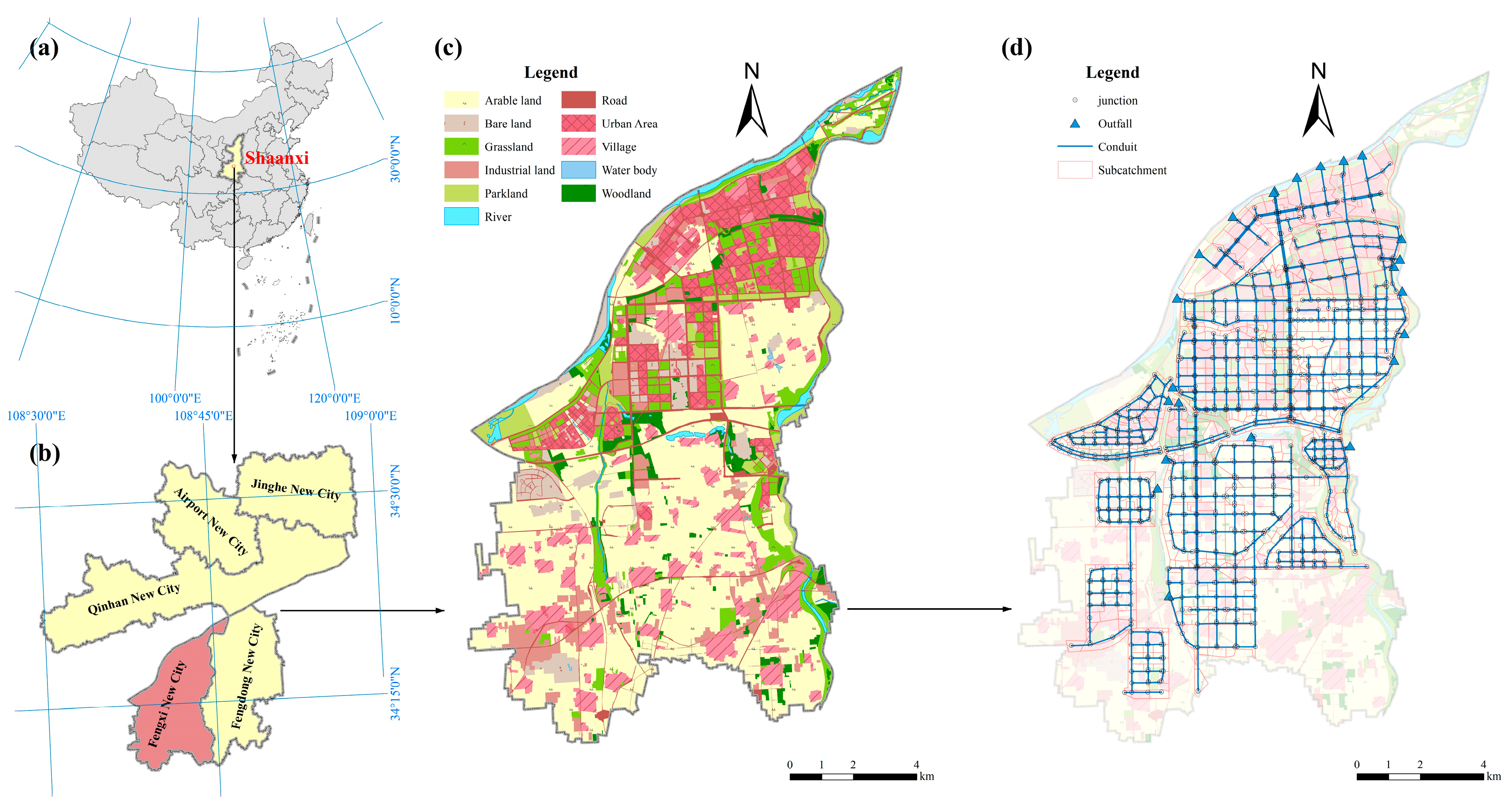
Localized centrally within Shaanxi Province, China, amidst the urban expanses of Xi’an and Xianyang, Fengxi New City assumes an important role as an integral component of the Xixian New District as a state-level New Area. Fengxi holds the esteemed status of being a national pilot sponge city on loess with a temperate continental monsoon semi-arid and semi-humid climate. Its global recognition by UNESCO in 2019 is noteworthy, designating it as a global eco-hydrology demonstration site (http://ecohydrology-ihp.org/demosites/view/1220, accessed on 9 April 2024). As was the case in this study, it assumes heightened significance due to its representative nature, rendering the proposed methodology notably forward-looking. The annual precipitation in this region averages around 520 mm, with the period from July to September contributing approximately 50% to the yearly rainfall. Notably, the summer precipitation is mostly in the form of intense storms, which are prone to natural disasters such as flooding, waterlogging, and soil erosion. Figure 1 shows the overview map of the study area.
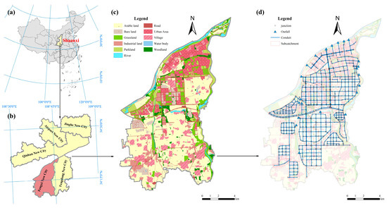
Figure 1.
Overview map of the study area. (a) Shaanxi, China; (b) Fengxi New City, Xixian New Area; (c) land use of Fengxi New City; (d) drainage system of the study area.
The type, source, and accuracy of the data used in this study are shown in Table 1.

Table 1.
Data sources, types, and accuracy.
2.2. Scenario Development of GI Installations
2.2.1. Suitability Analysis of GI
When compared to optimization strategies like the green strategy, blue strategy, and gray strategy, green infrastructure demonstrates clear advantages [57]. Green infrastructure encompasses various forms, such as rain gardens, bioretention, bioswales, green roofs, rain barrels, permeable pavements, riparian buffers, and constructed wetlands [58]. Rain gardens, permeable pavement, and green roofs have consistently demonstrated superior cost-effectiveness in various scholarly studies compared to other GIs [59]. Accordingly, these three GIs were selected for implementation in this study.
By typing in current situational data from the study area and consulting the Technical Guidelines for the Construction of Sponge Cities [60], we identified indicators of suitability factors for GIs along with their corresponding evaluation criteria. All three types of GI are subject to specific installation location restrictions. Green roofs are designated for installation on building rooftops, while rain gardens are best suited for woodland, grassland, and parkland areas. Permeable pavements, on the other hand, are ideally installed on sidewalks and open-parking areas [35,61,62]. In the case of green roofs, consideration is given to the building’s roofing type (flat or pitched) and its load capacity, expressed in terms of the building’s architectural design service life and structure in the paper. Buildings with an architectural design service life of 50 years or constructed with reinforced concrete are deemed capable of accommodating additional loads [63]. For rain gardens and permeable pavements, attention is directed towards factors such as the slope, soil type, and spatial requirements. It is crucial to place them at a distance from the building [62], following the Technical Guidelines for the Construction of Sponge Cities, which recommend a distance of more than 3 m to prevent the infiltration of stormwater runoff from impacting the building’s foundation.
The specifics are outlined in Table 2.
Table 2.
GI suitability factors and evaluation criteria.
The weights assigned to the chosen indicators were determined through the Analytic Hierarchy Process (AHP), a multi-criteria decision analysis method developed by Saaty [64]. AHP employs a scoring and ranking process to systematically evaluate multiple criteria and facilitate decision making [65]. Post obtaining raw scores from an expert-provided questionnaire, the indicator weights are calculated through judgment matrix operations, with the resulting scores used for ranking. A crucial step in AHP involves subjecting the calculated weights to a consistency test and evaluating the degree of consistency in expert judgments regarding indicator scores [66,67]. The Consistency Ratio (CR) below 0.1 was considered indicative of a reliable matrix, validating the usability of the obtained weights for subsequent evaluations [68].
To determine suitable areas for GI installation in the study area, a comprehensive evaluation was conducted by integrating various suitability indicators. Each indicator was assigned scores (5, 3, and 1 for suitable, generally suitable, and unsuitable, respectively). After deriving weights for the suitability indicators through AHP, the indicators were weighted and superimposed to determine the suitability score for GI installation across the study area. Subsequently, employing the natural breakpoint method, scores were categorized into three levels (suitable, generally suitable, and unsuitable), with areas deemed suitable and generally suitable identified for GI installation.
2.2.2. Scenario Development
The three selected GIs in this study exhibit distinct variations in cost-effectiveness, treatment efficacy, and spatial demands for user groups. In order to propose governance-oriented and diversified optimization alternatives, this study delineates the following alternatives, each tailored to specific cost considerations and user groups associated with different types of GI.
Baseline scenario: this represents rainfall simulation under current land use conditions. In this case, existing GI is added, reflecting the results of stormwater events occurring in the study area under current basic conditions.
Alter 1 scenario: Pursuing a region-wide total transformation. This scenario emphasizes shared utilization by residents. The impermeable open-parking lots and sidewalks are replaced with permeable pavements.
Alter 2 scenario: Focusing on resident participation and satisfaction. Rain gardens are strategically installed in green spaces around residential land.
Alter 3 scenario: Targeting the use of small-scale public areas. Green roofs are implemented on the roofs of public buildings.
Alter 4 scenario: Installing multiple GI combinations, which are shared by residents. This scenario introduces rain gardens alongside permeable paving and incorporates green roofs on public buildings.
Alter 5 scenario: Optimizing the strategy for robust runoff control and multiple GI combinations. Suitability evaluations guide the integration of rain gardens, green roofs (both on private residential and public buildings), and permeable paving within the designated suitability zone.
2.3. Model Simulation
2.3.1. Generalization of the Study Area
Through data collection and field research, as well as references to the Special Plan for Stormwater Engineering in Fengxi New City, Xixian New District, Shaanxi Province, and remote sensing images of the study area, the components, networks, and sub-catchment delineation of the drainage system were completed in the ArcGIS (v10.8, Redland CA). Subsequently, the drainage system (conduits, junctions, and outfalls) and sub-catchments were integrated into EPA-SWMM (v5.2) for hydrodynamic modeling. The study area was divided into 878 sub-catchments, 878 conduits, 878 junctions, and 23 outfalls, with a total area of 9098.61 ha and a total length of conduits of 343.50 km (shown in Figure 1d).
2.3.2. Storms Design
According to the Technical Guidelines for Low Impact Development of Sponge City Construction in Xixian New Area (Trial Version), the formula of the intensity–frequency–duration (IFD) relationship for the storm design in the study area is shown in Equation (1).
where is the rainfall intensity [L/(s∙ha)]; is the design return period (a); and is the rainfall duration (min).
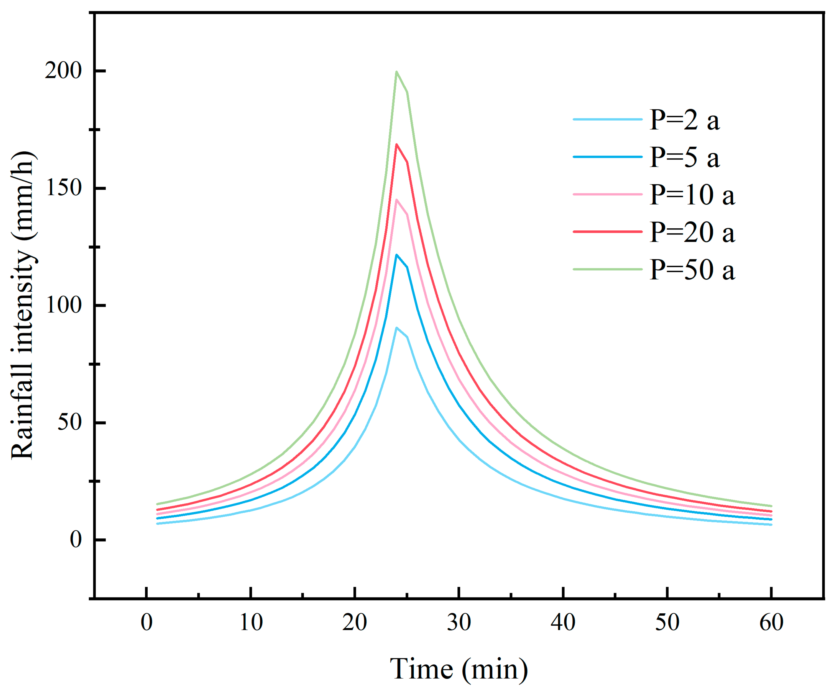
The Chicago rain pattern model is an uneven design rain pattern based on an intensity–duration–frequency relationship that divides the precipitation process into pre-peak and post-peak parts. It can generalize most rainfall types and can reflect average characteristics [69]. Due to these characteristics, scholars worldwide have widely employed the Chicago rain pattern model in related research, yielding favorable outcomes [70]. Thus, the Chicago rain pattern model was used as the rainfall simulation model with a duration of 60 min. The time-to-peak ratio is 0.405, referring to the range of values previously studied [71], and the time step is 1 min. The design return periods are 2, 5, 10, 20 and 50 a. The design rainfall intensity for different design return periods is shown in Figure 2.
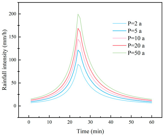
Figure 2.
Rainfall intensity distributions for different design return periods.
2.3.3. Parameters and Calibration for SWMM Model
Utilizing remote sensing images, we digitalized land use for the study area, enabling the calculation of impermeability for each sub-catchment and the overall impermeability of the entire area. The overall impermeability was quantified at 34.80%. We extracted the average slope for each sub-catchment from the Digital Elevation Model (DEM). To compute infiltration loss and conduit flow paths, we opted for the Horton model and the kinematic wave model, respectively. The reasonable range of parameters for sub-catchments and GIs was meticulously selected, referring to the Storm Water Management Model User’s Manual Version 5.1, sub-catchment characters, and pertinent literature [72,73]. These parameters underwent refinement during the calibration process.
Since measured or observed outfall data for some of the conduits were missing or limited, the model calibration in this study was carried out using a comprehensive runoff coefficient rate model [74]. The design criteria for the stormwater system in Fengxi New City included a 2 a design return period for general areas and a 3 a design return period for important areas. Using this method, it was confirmed that the runoff coefficient rate of the model varied between 0.41 and 0.46 under the stormwater system design criteria. According to the recommended values in Outdoor Drainage Design Standards (GB 50014-2021 [75]) and the Concise Drainage Design Manual compiled by the Beijing Municipal Design Research Institute (see Table 3 for the specific values) [76], the empirical runoff coefficient rate for 30–50% dense impervious land cover varied between 0.4 and 0.6, which proved the stability and reliability of the model, and indicated that the parameter settings of the model were more reasonable. The relevant parameter settings of this model are shown in Table 4.
Table 3.
Recommended values for the comprehensive runoff coefficient rate.
Table 4.
Key calibration parameters and GI characteristics of the SWMM model.
2.4. The Development of the Urban Stormwater Resilience Evaluation System
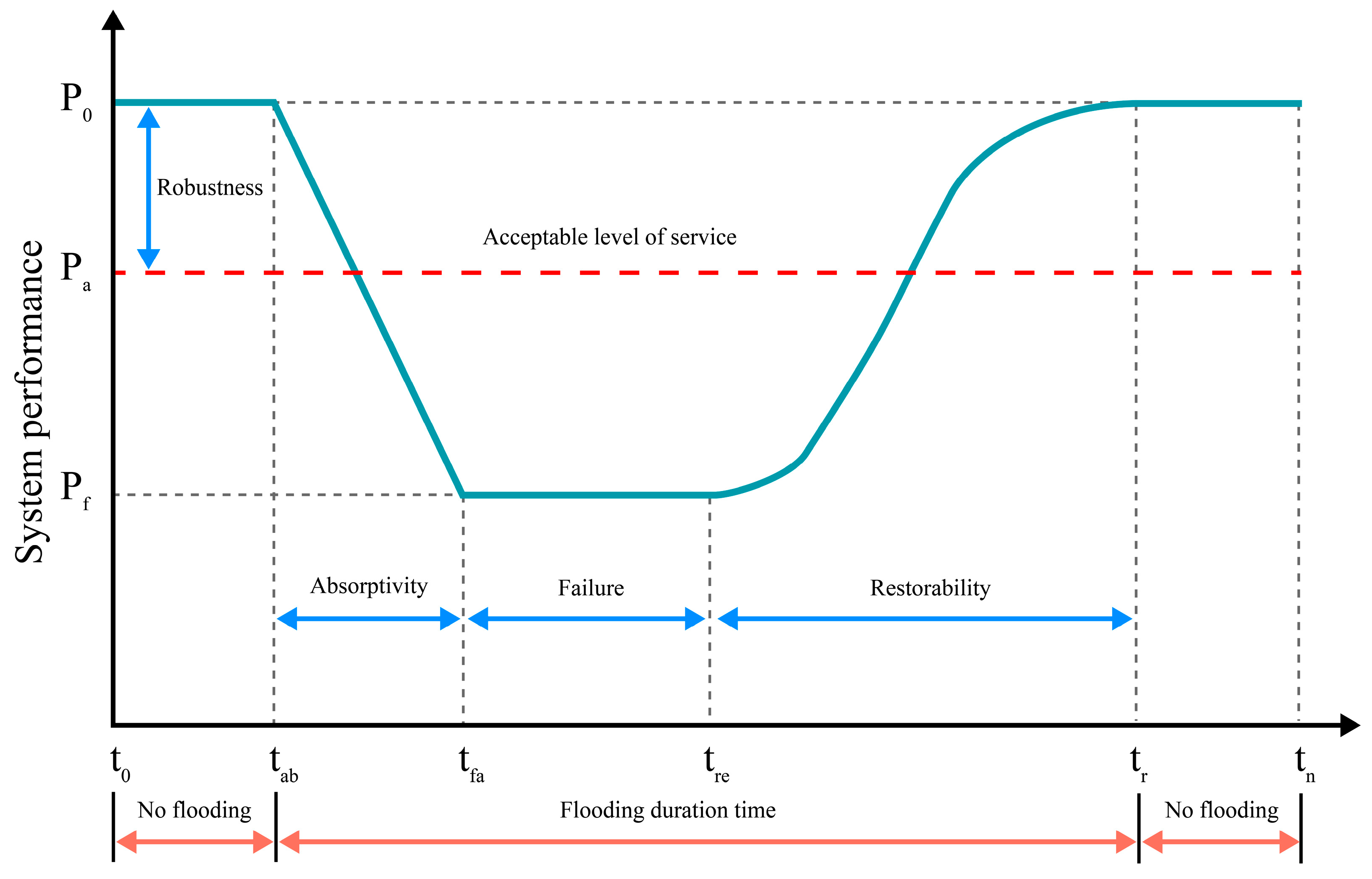
The resilience evaluation plays a crucial role in measuring the efficacy of sponge cities in stormwater management. CAS thinking posits that system agents possess dynamic characteristics and interact with each other, adapting to the environment and evolving into new systems. This theory underscores the system’s ability to maintain functionality amid disturbances and swiftly recover or attain alternative stable states [52]. The theoretical resilient system performance curve (as depicted in Figure 3) aligns with this concept and furnishes a nuanced understanding of resilient system behaviors related to a storm event [50]. The curves delineate various stages from stormwater occurrence to system recovery. Firstly, the absorption of stormwater runoff by the urban system at the beginning of the stormwater event reflects the ability of the system to interact with the outside world in CAS thinking. In addition to this, the amount of redundancy in the volume of the urban drainage system in the urban system at the onset of the stormwater event is a reflection of CAS thinking in terms of providing the system with the ability to maintain its original function. Finally, the duration required for the system to recover during the recovery phase is a reflection of the ability of this system to return to its original state in CAS thinking. Thus, we employed CAS thinking to construct the theoretical resilient system performance curve and introduce a stormwater resilience evaluation system with indicators encompassing absorptivity, robustness, and restorability.
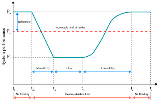
Figure 3.
Theoretical resilient system performance curve (adapted from Mugume et al. [50]).
2.4.1. Absorptivity Measurement for Urban Stormwater Resilience
Rainwater within the urban area undergoes processes such as evaporation, infiltration, retention within small catchments or contributes to surface runoff [51]. Excluding the surface runoff fraction, the remaining volume can be considered an expression of the sub-catchment’s absorptive capacity for rainfall. We quantified the absorptivity of the sub-catchment by employing the ratio of the difference between the rainfall and runoff volume to the total rainfall volume, as delineated in Equation (2).
where is the absorptivity of the sub-catchment ; is the total rainfall in sub-catchment ; and is the total runoff in sub-catchment . The resulting value falls within the range of [0, 1].
In quantifying the absorptivity of the resilient system, we calculated it as the product of the ratio of each sub-catchment’s area to the entire study area and the absorptivity of that sub-catchment. Then, we took their sums as the resilient system’s absorptivity. As we said earlier, there are a total of 878 sub-catchments. This formulation is expressed in Equation (3).
where is the absorptivity of resilient system under design return period ; is the area of sub-catchment ; is the total area of the study area; and is the absorptivity of sub-catchment under the design return period .
2.4.2. Robustness Measurement for Urban Stormwater Resilience
Robustness can be represented by reduced rainwater runoff due to the introduction of strategies that resist flood damage [77]. The existence of residual capacity within the conduit system before water exceeds its limits signifies the resilient system’s effectiveness in maintaining functionality amid challenges like flooding [51]. For the evaluation of individual conduits, we opted for the ratio of the remaining conduit capacity for the total capacity of the conduit during a stormwater event, formulated in Equation (4).
where is the robustness indicator of conduit ; is the maximum runoff volume of conduit during a stormwater event; is the total capacity of conduit ; and is the base discharge of conduit . The value of this result is in the range of [0, 1].
Similarly, in quantifying the robustness of the resilient system, we calculated it as the product of the ratio of each conduit volume to the total conduit volume and the robustness of that conduit. Then, we took their sums as the resilient system’s robustness. As we said earlier, there are a total of 878 conduits. This formulation is expressed in Equation (5).
where is the robustness of the resilient system under the design return period ; is the volume of conduit ; is the total volume of conduit ; and is the robustness of conduit under the design return period .
2.4.3. Restorability Measurement for Urban Stormwater Resilience
Restorability can be measured by the time it takes for the receptors to recover from a shock [78]. A swifter recovery, evidenced by a shorter flooding time, indicates superior system restorability [79]. Hence, we adopted the time duration of overflow for each junction within a sub-catchment as the restorability for that specific sub-catchment, as expressed in Equation (6).
where is the restorability of the sub-catchment ; is the overflow time of junctions in sub-catchment .
Similarly, in quantifying the restorability of the resilient system, we calculated it as the product of the ratio of each sub-catchment’s area to the entire study area and the restorability of that sub-catchment. Then, we took their sums as the resilient system’s restorability. As we said earlier, there are a total of 878 sub-catchments. This formulation is expressed in Equation (7).
where is the restorability of the resilient system under the design return period ; is the area of sub-catchment ; is the total area of the study area; and is the restorability of the junction corresponding to the sub-catchment under the design return period .
2.4.4. Using the Entropy Method to Determine Weights of Different Return Periods
The entropy method is applied for the assignment of weight to the indicators based on their dispersion, giving higher weights to more discrete indicators to highlight their distinctive characteristics [80]. Utilizing the entropy method, we determined the weights for each design return period to calculate the resilience score for each scenario. The initial step involved constructing a data matrix for n design return periods and m sub-catchments (junctions/conduits), representing the absorptivity (robustness/restorability) indicator of the ith sub-catchment (junction/conduit) under the jth return period. The data matrix is defined in Equation (8).
This data matrix is then used to find the weights for each design return period, as shown in Equations (9)–(11).
where is the entropy value of the jth design return period and is the weight of the entropy of the jth design return period.
2.4.5. Comprehensive Resilience Evaluation
Upon determining the weight for each design return period, the final resilience evaluation is derived by multiplying each indicator standardized value ( by its respective weight ().
A comprehensive evaluation of the resilient system requires a combination of three indicators. Although the values of absorptivity and robustness are in the same range of [0, 1], the restorability is different from the range of the other two indices. Therefore, a dimensionless normalization process becomes essential to align them on similar measurement scales. We employed min–max rescaling to normalize both positive and negative indicators [79]. A resilient system is deemed to exhibit a commendable absorptive capacity if the absorptivity surpasses 0.6 [51]. Similarly, a restorability exceeding 0.85 signifies inadequate support for resilient system recovery. For robustness, an indicator surpassing 0.5 indicates substantial robustness maintenance, while a value below 0.25 denotes insufficient robustness. Haghbin and Mahjouri [51] obtained a standard average value of 0.60 during the calculation of absorption capacity. In addition, they believed that the remaining 25% of the total capacity of the conduit proved that it has sufficient capacity, while Li et al. [79] argued that the results were poor when the accumulated flood time exceeded 1 h. Therefore, this study tried a flood accumulation time exceeding 0.85 h, indicating poor results. The normalization formula is presented in Equations (12)–(14).
where is the normalized value of absorptivity; is the normalized value of restorability; and is the normalized value of robustness. is the final value of absorptivity; is the final value of restorability; and is the final value of robustness.
Upon completing the normalization for each indicator, the scores for robustness, absorptivity, and restorability fell into the 0 to 1 category, where higher scores signify superior indicators. The comprehensive resilience evaluation results were computed, assuming equal weight for each indicator [81]. The formula for the resilient system comprehensive resilience evaluation score is presented in Equation (15).
3. Results
3.1. Spatial Layouts of GI Installations
3.1.1. Weights for GI Suitability Analysis
Ten experts from relevant fields were engaged to evaluate the suitability factors for GI installation using the AHP method (in Table 5). In the case of green roofs, when prioritizing the necessity of their installation on building rooftops, particular emphasis was placed on the roof type, constituting the majority of the proportion (0.725). For rain gardens and permeable pavements, which are essential for rainwater absorption, the soil type played a pivotal role, representing the major share of their respective indicators at 0.728 and 0.689. The calculated weights using the AHP method exhibited CR values for judgment matrices in relation to green roofs, rain gardens, and permeable pavements as 0.05, 0.05, and 0.04, respectively. All CR values were below 0.1, affirming the reliability of the indicator weights. The results notably indicate that experts recognize the soil type as a determining factor for the suitability of installing rain gardens and permeable pavements. In the case of green roofs, the type of soil also plays a crucial role in determining suitability.
Table 5.
Weight for GI suitability analysis.
3.1.2. Spatial Layouts for Different Types of GI
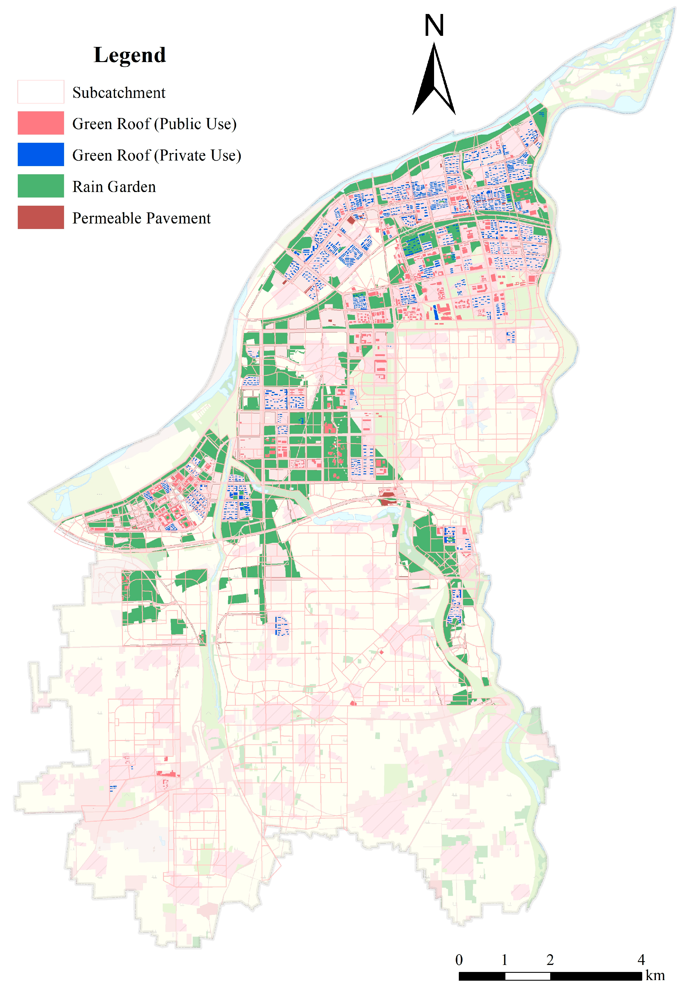
Following the determination of indicator weights, ArcGIS was employed to overlay and assign weights to calculate the suitability score for different types of GI in the study area. Based on the suitability score, the natural breakpoint method was used to classify the installation area of each GI into three classes (suitable, generally suitable, and unsuitable), selecting the suitable and the generally suitable portion of the GI as the installation area of the GI. (in Figure 4). Predominantly, the suitability areas for the three GIs were concentrated in the northern and western areas of the study area, with comparatively fewer areas in the south and east. The suitability areas for green roofs covered 2191 building roofs, spanning 336.91 ha and comprising 182.76 ha of public-use building roofs and 154.15 ha of private-use building roofs. Additionally, there were 1293.83 ha of rain garden suitability areas and a total of 178.39 ha of permeable pavement suitability areas.
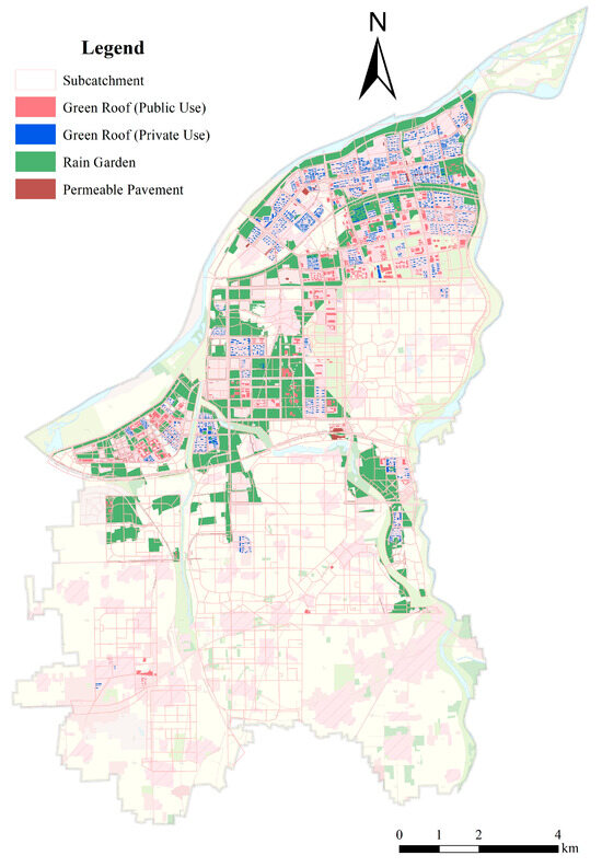
Figure 4.
Spatial layouts for different types of GI.
According to the storylines and assumptions of scenarios in Section 2.2.2, the GI installation area for each alternative scenario was determined (refer to Table 6). Alter 1 and Alter 3 accounted for the smallest portion of the entire region, comprising only 2.01% and 1.96%, respectively. In contrast, Alter 4 and Alter 5 covered the largest areas, representing 18.19% and 19.88% of the entire region. Notably, Alter 4 and Alter 5 also featured the most extensive combination of GI installation.
Table 6.
Area of GI layout for alternatives.
3.2. Scenario Simulation in SWMM
The GI layout derived in Section 3.1.2 was incorporated into the SWMM model of the study area to simulate the runoff process. And then the foundational data were obtained for calculating and computing each resilience indicator. The key elements selected for quantifying the resilience indicators included the total runoff volume of sub-catchments, the overflow time of junctions, and the residual volume ratio in the conduit system. These elements served to precisely measure the resilient system’s performance during stormwater events.
In the runoff simulation results for each sub-catchment, the northern and western areas of the study area had a high runoff volume in the simulations for different design return periods, and the situation in this area improved considerably with the installation of a wide range of GIs, but the runoff volume in other parts of the sub-catchment was still in a state of excessive volume. Alter 5 exhibited the most pronounced performance on reducing the runoff volume, with 130 sub-catchments experiencing a reduction of over 50% and the largest reaching an impressive 89.80% reduction in the design return period of 50 a. The number of junctions experiencing overflows decreased, and the duration of overflows improved with the inclusion of GI in the alternatives. Nevertheless, some junctions in the eastern area of the study area continued to experience overflows in simulations of the design return period. Alter 4 demonstrated the most significant improvement in junction overflow conditions, with 60 junctions transitioning from overflow to non-overflow in the design return period of 10 a, constituting 16.08% of the number of overflowed junctions in the baseline scenario under the same return period. Residual volume ratios in the conduit system also exhibited an improvement during the simulation, with Alter 4 showing the most substantial enhancement. A total of 73 conduits displayed a 25% improvement in residual volume ratios for a design return period of 50 a, with the highest degree of enhancement reaching 91.03%.
SWMM simulations provided insights into the flooding situations under each scenario, highlighting improved outcomes with the incorporation of GI, particularly in Alters 4 and 5, which demonstrated the most significant performance.
3.3. Stormwater Resilience Evaluation for Different Alternatives
Subsequently, the simulation outcomes for each scenario were utilized to compute individual resilience indicators.
3.3.1. The Absorptivity for Different Scenarios
Absorptivity was determined for each scenario using the entropy method, where the greater the difference between the rainfall and runoff volume in a sub-catchment for the same design return period, the higher the absorptivity. The weights for absorptivity were computed for each design return period, as detailed in Table 7. Notably, for smaller design return periods (2, 5, and 10 a), the variations in the surface runoff between sub-catchments diminished with the incorporation of GI in the alternatives. In contrast, for larger design return periods (20, 50 a), the surface runoff differences increased with the augmentation of GI in the alternatives. The most pronounced differences in the surface runoff between sub-catchments occurred for a design return period of 50 a, underscoring the heightened significance of disastrous regional flood control and drainage measures.
Table 7.
The weighting of absorptivity in each scenario for different design return periods.
3.3.2. The Robustness for Different Scenarios
Robustness was determined for each scenario using the entropy method, where a higher duration of overflow for each junction indicated poorer robustness. The weights for robustness were computed for each design return period, as detailed in Table 8. The robustness among alternatives for the same design return period exhibited minimal variation. The most pronounced disparities in the ratio of conduit maximum capacity to its capacity between sub-catchments were observed at a design return period of 50 a.
Table 8.
The weighting of robustness in each scenario for different design return periods.
3.3.3. The Restorability for Different Scenarios
Restorability was determined for each scenario using the entropy method, where a higher time duration of overflow for each junction indicated poorer restorability. Weights for restorability were computed for each design return period, as detailed in Table 9. As the design return period increased, the difference in the time duration of overflow for each junction became smaller.
Table 9.
The weighting of restorability in each scenario for different design return periods.
3.3.4. The Comprehensive Resilience Indicator Evaluation
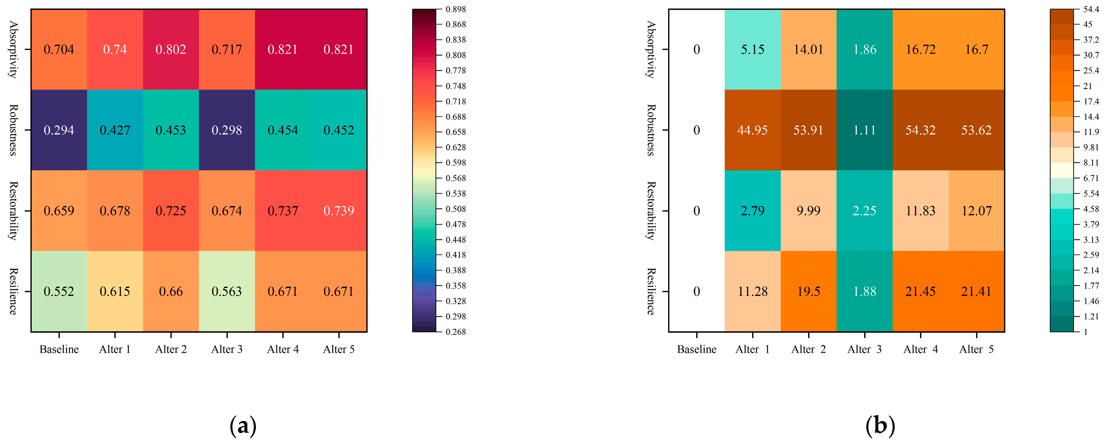
Figure 5 presents the standardized evaluation results for each scenario, accompanied by the percentage increase in standardized evaluation results relative to the baseline scenario. Observing the absorptivity, Alter 3 exhibited negligible improvement, while Alter 2 demonstrated a more noticeable enhancement, and the combined alternatives, Alter 4 and Alter 5, showed the most significant improvements. Minimal disparities between alternatives and the baseline were evident in the restorability. Notably, improvements in the robustness were substantial across all alternatives except for Alter 3. Regarding the overall resilience, alternatives incorporating a single type of GI (e.g., Alter 3) displayed limited improvement, with only a 1.88% increase compared to the baseline. In contrast, Alter 1 exhibited a more pronounced improvement, and Alter 2 manifested the most substantial enhancement, registering a 19.5% increase, approaching the efficacy of combined alternatives. Combined alternatives, Alter 4 and Alter 5, yielded the most favorable outcomes, both showing improvements in resilience exceeding 20%, albeit without significant differentiation.
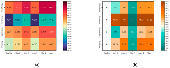
Figure 5.
(a) Standardized evaluation results of alternatives; (b) percentage increase in the standardized evaluation results of alternatives compared to the baseline.
4. Discussion
4.1. GI Suitability Analysis and Spatial Layouts
Numerous studies have evaluated the suitability of GI based on diverse criteria, such as ecosystem service contributions, ecological connectivity, and social and natural factors [62,82]. In the context of sponge city construction, which heavily relies on water ecological infrastructure techniques [83], our approach extends the evaluation to encompass engineering conditions. This includes the integration of specific indicators like roof type, architectural design life, and the building structure for green roofs. The incorporation of these indicators contributes to the generation of more scientific and practical layouts for GI installation within the urban environment.
In the analysis of the GI installation layout, it was evident that permeable pavements exhibit the least suitability, encompassing a mere 2.01% of the study area. This finding aligns with similar observations in the studies of other scholars; for instance, Chuang et al. [1] reported a comparable 2% coverage using the water footprint method. This was due to the limited size of the area consisting of sidewalks and parking lots where permeable pavement could be placed [35]. Moreover, the predominant suitability areas for GI were concentrated in the western and northern parts of the study area. This distribution is presumed to be influenced by the southern and eastern areas of Fengxi New City being predominantly cultivated land.
4.2. Selection and Improvement of Indicators for Urban Stormwater Resilience
This paper presents an innovative urban stormwater resilience evaluation system designated for sponge cities, evaluating the advantages of GI implementation to form flooding resilience. We improved the theoretical system performance curve proposed by Mugume et al. [50] by integrating CAS thinking with absorptivity, restorability, and robustness as indicators of the urban stormwater resilience evaluation system. This adaptive system approach allows for a full understanding of how waterlogging dynamically emerges and how the various sub-systems in the city dynamically change amid stormwater.
As mentioned earlier, few existing urban stormwater resilience evaluation indicator systems have been constructed from the perspective of the intrinsic features of the resilient system. In the selection of indicator quantification, we utilized the ratio of the difference between rainfall and runoff volume for each sub-catchment to the total rainfall volume to express absorptivity, which is one of the innovations of our study. This metric effectively captures the system’s intrinsic capability to autonomously absorb perturbations, showcasing the extent to which it minimizes the impact of such disturbances [84]. It also takes into account the ability of GI to support urban water sources, the security of urban water supply (stormwater reuse), and the enhancement of urban sustainability and adaptability. Robustness was quantified by the ratio of the remaining conduit capacity to total conduit capacity, emphasizing its role in reducing and delaying runoff by enhancing stormwater infiltration and storage capacity [77]. This indicator provides an accurate indication of the volume and water storage capacity of the entire urban conduit system in response to external shocks, reflecting how well it maintains its function and avoids complete functional collapse [85], demonstrating the engineering resilience of urban conduits in response to stormwater flooding. Restorability, represented by the overflow time of junctions, embodies the dynamic nature of repairs and serves as an apt measure to reflect the coordination efficiency among GIs [84]. This indicator also reflects the resilience of the system as a whole in the occurrence of flooding. This evaluation system can provide a better understanding of the system’s internal structure and operating mechanisms.
Three key elements (conduits, junctions, and sub-catchments) were selected for the calculation of these three resilience indicators, aiming to provide comprehensive coverage that is consistent with the different phases of the simulation curve of the stormwater process. They are all directly accessible from the SWMM simulation results, ensuring a scientifically sound and reasonable evaluation with reduced uncertainty.
As previously highlighted, a single design return period is not sufficient to represent the actual capability of the alternatives, but a combination of simulated values for various design return periods can improve the overall evaluation. Therefore, the performance of different alternatives with various return periods (2, 5, 10, 20, and 50 a) was considered in the evaluation system, and the entropy method was used to determine the significance of each design return period. Higher weights were assigned to the design return periods with high variability, which were then multiplied with the simulation results to obtain the three indicators for evaluating urban stormwater resilience. The quantitative values derived from this method take into account the various alternatives that the scheme may be subjected to in the course of real-life implementation and provide a scientific and reasonable evaluation of the scheme’s capability, as well as a more supportive basis for future retrofitting and planning.
4.3. The Roles of GI in Improving Urban Stormwater Resilience
Spatial differences in the suitability of GI installations lead to differences in the layout of GI installations. As a result, there were some areas that were unsuitable for GI installation even though the surface runoff volume was high. Moreover, in some areas in the eastern area of the study area, insufficient conduit diameter and unsuitability for GI installations resulted in high junction overflow times.
The results emphasized a substantial enhancement in urban stormwater resilience. For this single type of GI installation, rain gardens consistently maintained a high level of regulatory performance, and green roofs were the least effective among the three, which was corroborated by the results of the previous research in the same study area [70]. In contrast, permeable pavements were able to achieve better resilience enhancement with a smaller area [48]. In addition, the study found that the GI combination alternatives resulted in a greater increase in resilience enhancement than the alternatives with just a single type of GI, which is also consistent with previous research findings [86,87]. Overall, the results suggest that the use of GI is effective in increasing the flood resilience of the resilient system [51].
4.4. Suggestions for Building Sponge City
Initially, in the evaluation of the GI installation’s suitability, consideration should be given to the constraints posed by engineering conditions. Solely focusing on natural factors in the establishment of GI may lead to the oversight of human activities during urban development and construction. This is particularly pertinent for GI constructed into buildings, such as green roofs, where the impact of engineering technology is substantial. Consequently, it is advisable to incorporate engineering factors in future evaluations of the appropriateness of GI to ensure a comprehensive and accurate evaluation.
Subsequently, when evaluating the role of GI in improving stormwater resilience, the results of various design return periods need to be considered in the evaluation process, combining the performance of multiple alternatives. Resilience also needs to be evaluated by considering the intrinsic features of the resilient system.
Moreover, in the context of selecting GI for sponge city construction, considering the challenges associated with retrofitting GI on private land and the performance of GI implementation, the scenario for installing rain gardens, permeable paving, and green roofs for public buildings proves to be more economically efficient than the scenario for installing all GIs. In situations with limited financial resources, prioritizing the construction of rain gardens can offer relatively better results with constrained funds. It is advisable to avoid exclusively opting for green roofs, as this may represent the least efficient alternative scenario.
Finally, areas unsuitable for GI but experiencing high surface runoff should enhance monitoring, control, and management measures to improve resilience [40]. Alternatively, augmenting wetlands or open green spaces is advocated to diminish urban impervious areas [88].
4.5. Limitations and Future Research Directions
This study’s limitations include a focus on the current GI installation layout and resilience evaluation within existing land use without considering potential future changes resulting from ongoing urban development. Consequently, as impervious surfaces increase in the future, it is likely that the current scenario will become less instructive for future scenarios. In addition, the scale of this study is wide, and specific analyses for city streets or lots are missing, especially for the control of runoff performance over time in the draining systems. Moreover, it is important to note that the identified optimal improvement options are tailored specifically to the study area and may only contribute to local stormwater management. But the methodology in this study remains valuable for urban planners, aiding in the identification of optimal GI solutions for enhancing urban resilience. Future research could explore changes in impermeable areas and the impact of climate change on urban stormwater resilience.
Furthermore, this study’s resilience evaluation focuses solely on the effectiveness of resilient system responses concerning stormwater management, neglecting external factors such as government management and public participation in flood response. Incorporating input from various stakeholders in identifying project priorities and garnering public support for improvement plans could enhance collective action during stormwater events [89]. Additionally, population distribution, particularly among vulnerable groups, is crucial for assessing restorability [47]. In addition, in the analysis of natural disaster risk evaluation, studies on the vulnerability of the disaster-bearing body have become a hot content [90]. Future resilience research should encompass external factors like governmental policies, disaster mitigation programs, and public participation while also addressing population distribution and vulnerability to provide a more comprehensive understanding of urban stormwater resilience capacity.
5. Conclusions
This study centered on Fengxi New City, China, and utilized SWMM to evaluate both the suitability of GI and the overall resilience of the resilient system. Our findings offer crucial insights into optimizing the layouts of GI installations and fortifying stormwater resilience.
Firstly, in GI installation suitability analysis and spatial layouts, we integrated engineering and technical factors for a comprehensive evaluation of GI’s suitability. The analysis revealed limited suitability for permeable pavement (2.01% coverage). Suitability areas were concentrated in the western and northern areas of the study areas, which was attributed to the southern and eastern areas being predominantly cultivated and less developed. Secondly, in terms of urban stormwater resilience, we introduced a comprehensive evaluation system comprising absorptivity, robustness, and recoverability. Employing the entropy method, we determined the significance of each rainfall return period and integrated the simulation results under multiple design return periods to achieve the resilience evaluation of each scenario rather than only simulating an extreme design return period or a specific design return period. The results demonstrated a notable improvement in resilience with GI implementations. Lastly, varying performance was observed among GIs, with rain gardens consistently proving effective. The combination of multiple GIs exhibited substantial resilience enhancement, emphasizing the synergistic benefits of diverse GI alternatives. This methodology provides valuable insights for urban planners, offering a robust foundation for deriving optimal alternatives that can maximize the benefits of GI and bolster urban stormwater resilience.
Author Contributions
Conceptualization, X.F. and Y.M.; Methodology, X.F., Y.L. and X.B.; Data acquisition, Y.M. and Y.H.; Data Processing, Y.M., Y.L. and Y.H.; Writing—original draft preparation, Y.M., Y.L. and X.Y.; Writing review and editing, X.F. and X.B.; Fund acquisition, X.F. and Y.M. All authors have read and agreed to the published version of the manuscript.
Funding
This research was performed and supported while X.F. held funding (funding number: Z1090221023, 2022JM-204) from the Northwest A&F University, China, and the Shaanxi Science and Technology Agency, China. This research is also partially funded by the Innovation and Entrepreneurship Training Plan for Chinese College Students (funding number: S202310712577) held by Y.M.
Institutional Review Board Statement
Not applicable.
Informed Consent Statement
Not applicable.
Data Availability Statement
Data are contained within the article.
Acknowledgments
In addition, we would like to thank Yutong Da and Huiting Deng, who are students at the College of Landscape Architecture and Arts, Northwest A&F University, for their contributions to the collection of land use data in the early stages of this study.
Conflicts of Interest
The authors declare no conflicts of interest.
References
- Chuang, W.-K.; Lin, Z.-E.; Lin, T.-C.; Lo, S.-L.; Chang, C.-L.; Chiueh, P.-T. Spatial allocation of LID practices with a water footprint approach. Sci. Total Environ. 2023, 859, 160201. [Google Scholar] [CrossRef]
- Qiao, X.-J.; Liao, K.-H.; Randrup, T.B. Sustainable stormwater management: A qualitative case study of the Sponge Cities initiative in China. Sustain. Cities Soc. 2020, 53, 101963. [Google Scholar] [CrossRef]
- Yao, Y.; Li, J.; Lv, P.; Li, N.; Jiang, C. Optimizing the layout of coupled grey-green stormwater infrastructure with multi-objective oriented decision making. J. Clean. Prod. 2022, 367, 133061. [Google Scholar] [CrossRef]
- Zhang, Z. Can the Sponge City Project improve the stormwater drainage system in China?—Empirical evidence from a quasi-natural experiment. Int. J. Disaster Risk Reduct. 2022, 75, 102980. [Google Scholar] [CrossRef]
- Lu, G.; Wang, L. An Integrated Framework of Green Stormwater Infrastructure Planning—A Review. Sustainability 2021, 13, 13942. [Google Scholar] [CrossRef]
- Zhu, Y.; Xu, C.; Liu, Z.; Yin, D.; Jia, H.; Guan, Y. Spatial layout optimization of green infrastructure based on life-cycle multi-objective optimization algorithm and SWMM model. Resour. Conserv. Recycl. 2023, 191, 106906. [Google Scholar] [CrossRef]
- Anker, Y.; Mirlas, V.; Gimburg, A.; Zilberbrand, M.; Nakonechny, F.; Meir, I.; Inbar, M. Effect of rapid urbanization on Mediterranean karstic mountainous drainage basins. Sustain. Cities Soc. 2019, 51, 101704. [Google Scholar] [CrossRef]
- Berndtsson, R.; Becker, P.; Persson, A.; Aspegren, H.; Haghighatafshar, S.; Jönsson, K.; Larsson, R.; Mobini, S.; Mottaghi, M.; Nilsson, J.; et al. Drivers of changing urban flood risk: A framework for action. J. Environ. Manag. 2019, 240, 47–56. [Google Scholar] [CrossRef]
- Zhang, J.; Han, Y.; Qiao, X.-J.; Randrup, T.B. Citizen Willingness to Pay for the Implementation of Urban Green Infrastructure in the Pilot Sponge Cities in China. Forests 2023, 14, 474. [Google Scholar] [CrossRef]
- Wang, R.; Brent, D.; Wu, H. Willingness to pay for ecosystem benefits of green stormwater infrastructure in Chinese sponge cities. J. Clean. Prod. 2022, 371, 133462. [Google Scholar] [CrossRef]
- Zellner, M.; Massey, D.; Minor, E.; Gonzalez-Meler, M. Exploring the effects of green infrastructure placement on neighborhood-level flooding via spatially explicit simulations. Comput. Environ. Urban Syst. 2016, 59, 116–128. [Google Scholar] [CrossRef]
- Bai, Y.; Li, Y.; Zhang, R.; Zhao, N.; Zeng, X. Comprehensive Performance Evaluation System Based on Environmental and Economic Benefits for Optimal Allocation of LID Facilities. Water 2019, 11, 341. [Google Scholar] [CrossRef]
- Zölch, T.; Henze, L.; Keilholz, P.; Pauleit, S. Regulating urban surface runoff through nature-based solutions—An assessment at the micro-scale. Environ. Res. 2017, 157, 135–144. [Google Scholar] [CrossRef]
- Wang, R.; Wu, H.; Chiles, R. Ecosystem Benefits Provision of Green Stormwater Infrastructure in Chinese Sponge Cities. Environ. Manag. 2022, 69, 558–575. [Google Scholar] [CrossRef]
- Wang, Y.; Liu, X.; Huang, M.; Zuo, J.; Rameezdeen, R. Received vs. given: Willingness to pay for sponge city program from a perceived value perspective. J. Clean. Prod. 2020, 256, 120479. [Google Scholar] [CrossRef]
- Zhang, J.; Feng, X.; Shi, W.; Cui, J.; Peng, J.; Lei, L.; Zhang, J.; Astell-Burt, T.; Jiang, Y.; Ma, J. Health promoting green infrastructure associated with green space visitation. Urban For. Urban Green. 2021, 64, 127237. [Google Scholar] [CrossRef]
- Guan, X.; Wang, J.; Xiao, F. Sponge city strategy and application of pavement materials in sponge city. J. Clean. Prod. 2021, 303, 127022. [Google Scholar] [CrossRef]
- Xiang, C.Y.; Liu, J.H.; Shao, W.W.; Mei, C.; Zhou, J.J. Sponge city construction in China: Policy and implementation experiences. Water Policy 2019, 21, 19–37. [Google Scholar] [CrossRef]
- Nieuwenhuijsen, M.J. Green Infrastructure and Health. Annu. Rev. Public Health 2021, 42, 317–328. [Google Scholar] [CrossRef]
- Ying, J.; Zhang, X.; Zhang, Y.; Bilan, S. Green infrastructure: Systematic literature review. Econ. Res. Ekon. Istraživanja 2021, 35, 343–366. [Google Scholar] [CrossRef]
- Mertens, E.; Stiles, R.; Karadeniz, N. Green May Be Nice, but Infrastructure Is Necessary. Land 2022, 11, 89. [Google Scholar] [CrossRef]
- Nguyen, T.T.; Ngo, H.H.; Guo, W.; Wang, X.C.; Ren, N.; Li, G.; Ding, J.; Liang, H. Implementation of a specific urban water management—Sponge City. Sci. Total Environ. 2019, 652, 147–162. [Google Scholar] [CrossRef]
- Habtemariam, L.W.; Herslund, L.B.; Mguni, P. What makes a champion for landscape-based storm water management in Addis Ababa? Sustain. Cities Soc. 2019, 46, 101378. [Google Scholar] [CrossRef]
- Voghera, A.; Giudice, B. Evaluating and Planning Green Infrastructure: A Strategic Perspective for Sustainability and Resilience. Sustainability 2019, 11, 2726. [Google Scholar] [CrossRef]
- He, L.; Li, S.; Cui, C.-H.; Yang, S.-S.; Ding, J.; Wang, G.-Y.; Bai, S.-W.; Zhao, L.; Cao, G.-L.; Ren, N.-Q. Runoff control simulation and comprehensive benefit evaluation of low-impact development strategies in a typical cold climate area. Environ. Res. 2022, 206, 112630. [Google Scholar] [CrossRef]
- Huang, J.J.; Xiao, M.; Li, Y.; Yan, R.; Zhang, Q.; Sun, Y.; Zhao, T. The optimization of Low Impact Development placement considering life cycle cost using Genetic Algorithm. J. Environ. Manag. 2022, 309, 114700. [Google Scholar] [CrossRef]
- Apud, A.; Faggian, R.; Sposito, V.; Martino, D. Suitability Analysis and Planning of Green Infrastructure in Montevideo, Uruguay. Sustainability 2020, 12, 9683. [Google Scholar] [CrossRef]
- Grunwald, L.; Heusinger, J.; Weber, S. A GIS-based mapping methodology of urban green roof ecosystem services applied to a Central European city. Urban For. Urban Green. 2017, 22, 54–63. [Google Scholar] [CrossRef]
- Liu, Z.; Yang, Y.; Hou, J.; Jia, H. Decision-Making Framework for GI Layout Considering Site Suitability and Weighted Multi-Function Effectiveness: A Case Study in Beijing Sub-Center. Water 2022, 14, 1765. [Google Scholar] [CrossRef]
- Meerow, S.; Newell, J.P. Spatial planning for multifunctional green infrastructure: Growing resilience in Detroit. Landsc. Urban Plan. 2017, 159, 62–75. [Google Scholar] [CrossRef]
- Wu, W.; Yuan, Y.; Huang, C.; Dong, W.; Fu, Z. Urban Green Land Ecological Suitability Assessment Based on GIS in Arid Areas: Beitun City, Xinjiang, as an Example. Pol. J. Environ. Stud. 2021, 30, 5871–5883. [Google Scholar] [CrossRef]
- Zhou, Y.; Wu, X. Identification of priority areas for green stormwater infrastructure based on supply and demand evaluation of flood regulation service. Environ. Dev. 2023, 45, 100815. [Google Scholar] [CrossRef]
- Wang, H.W.; Dodd, A.; Ko, Y.K. Resolving the conflict of greens: A GIS-based and participatory least-conflict siting framework for solar energy development in southwest Taiwan. Renew. Energy 2022, 197, 879–892. [Google Scholar] [CrossRef]
- Brom, P.; Engemann, K.; Breed, C.; Pasgaard, M.; Onaolapo, T.; Svenning, J.C. A Decision Support Tool for Green Infrastructure Planning in the Face of Rapid Urbanization. Land 2023, 12, 415. [Google Scholar] [CrossRef]
- Fu, X.; Hopton, M.E.; Wang, X.H. Assessment of green infrastructure performance through an urban resilience lens. J. Clean. Prod. 2021, 289, 125146. [Google Scholar] [CrossRef]
- Wang, X.; Wang, C.X.; Shi, J.L. Evaluation of urban resilience based on Service-Connectivity-Environment (SCE) model: A case study of Jinan city, China. Int. J. Disaster Risk Reduct. 2023, 95, 103828. [Google Scholar] [CrossRef]
- Liang, C.M.; Zhang, X.; Xu, J.; Pan, G.Y.; Wang, Y. An integrated framework to select resilient and sustainable sponge city design schemes for robust decision making. Ecol. Indic. 2020, 119, 106810. [Google Scholar] [CrossRef]
- Lu, P.J.; Sun, Y.M.; Steffen, N. Scenario-based performance assessment of green-grey-blue infrastructure for flood-resilient spatial solution: A case study of Pazhou, Guangzhou, greater Bay area. Landsc. Urban Plan. 2023, 238, 104804. [Google Scholar] [CrossRef]
- Ma, Y.C.; Jiang, Y.; Swallow, S. China’s sponge city development for urban water resilience and sustainability: A policy discussion. Sci. Total Environ. 2020, 729, 139078. [Google Scholar] [CrossRef]
- Tansar, H.; Duan, H.F.; Mark, O. A multi-objective decision-making framework for implementing green-grey infrastructures to enhance urban drainage system resilience. J. Hydrol. 2023, 620, 129381. [Google Scholar] [CrossRef]
- Zuniga-Teran, A.A.; Gerlak, A.K.; Mayer, B.; Evans, T.P.; Lansey, K.E. Urban resilience and green infrastructure systems: Towards a multidimensional evaluation. Curr. Opin. Environ. Sustain. 2020, 44, 42–47. [Google Scholar] [CrossRef]
- de Bruijn, K.; Buurman, J.; Mens, M.; Dahm, R.; Klijn, F. Resilience in practice: Five principles to enable societies to cope with extreme weather events. Environ. Sci. Policy 2017, 70, 21–30. [Google Scholar] [CrossRef]
- Zhai, G.F. Resilient Planning Responses to Urban Flood Disasters in the Context of Climate Change: Key Concepts, Fundamental Ideas, and a Comprehensive Framework. Urban Plan. Forum 2024, 29–37, (In Chinese with English abstract). [Google Scholar] [CrossRef]
- Cao, F.F.; Xu, X.F.; Zhang, C.L.; Kong, W.B. Evaluation of urban flood resilience and its Space-Time Evolution: A case study of Zhejiang Province, China. Ecol. Indic. 2023, 154, 110643. [Google Scholar] [CrossRef]
- Li, J.; Jiang, Y.; Zhai, M.; Gao, J.; Yao, Y.; Li, Y. Construction and application of sponge city resilience evaluation system: A case study in Xi’an, China. Environ. Sci. Pollut. Res. 2023, 30, 62051–62066. [Google Scholar] [CrossRef]
- Datola, G. Implementing urban resilience in urban planning: A comprehensive framework for urban resilience evaluation. Sustain. Cities Soc. 2023, 98, 104821. [Google Scholar] [CrossRef]
- Chang, Y.S.; Ho, H.C.; Huang, L.Y. Evaluation of low impact development for resilient capacity in urban area with flood resilience index. J. Flood Risk Manag. 2023, 16, e12877. [Google Scholar] [CrossRef]
- Zhang, Z.; Hu, W.; Wang, W.; Zhou, J.; Liu, D.; Qi, X.; Zhao, X. The hydrological effect and uncertainty assessment by runoff indicators based on SWMM for various LID facilities. J. Hydrol. 2022, 613, 128418. [Google Scholar] [CrossRef]
- Zhang, Z.; Zhang, J.Q.; Zhang, Y.C.; Chen, Y.A.; Yan, J.H. Urban Flood Resilience Evaluation Based on GIS and Multi-Source Data: A Case Study of Changchun City. Remote Sens. 2023, 15, 1872. [Google Scholar] [CrossRef]
- Mugume, S.N.; Butler, D. Evaluation of functional resilience in urban drainage and flood management systems using a global analysis approach. Urban Water J. 2017, 14, 727–736. [Google Scholar] [CrossRef]
- Haghbin, S.; Mahjouri, N. Quantifying and improving flood resilience of urban drainage systems based on socio-ecological criteria. J. Environ. Manag. 2023, 339, 117799. [Google Scholar] [CrossRef]
- Shen, T.; Gao, C. Sustainability in Community Building: Framing Design Thinking Using a Complex Adaptive Systems Perspective. Sustainability 2020, 12, 6679. [Google Scholar] [CrossRef]
- Rabori, A.M.; Ghazavi, R. Urban Flood Estimation and Evaluation of the Performance of an Urban Drainage System in a Semi-Arid Urban Area Using SWMM. Water Environ. Res. 2018, 90, 2075–2082. [Google Scholar] [CrossRef]
- Zhang, J.X.; Wang, H.M.; Huang, J.; Sun, D.C.; Liu, G.F. Evaluation of Urban Flood Resilience Enhancement Strategies—A Case Study in Jingdezhen City under 20-Year Return Period Precipitation Scenario. Isprs Int. J. Geo-Inf. 2022, 11, 285. [Google Scholar] [CrossRef]
- Guptha, G.C.; Swain, S.; Al-Ansari, N.; Taloor, A.K.; Dayala, D. Assessing the role of SuDS in resilience enhancement of urban drainage system: A case study of Gurugram City, India. Urban Clim. 2022, 41, 101075. [Google Scholar] [CrossRef]
- Dell, T.; Razzaghmanesh, M.; Sharvelle, S.; Arabi, M. Development and Application of a SWMM-Based Simulation Model for Municipal Scale Hydrologic Assessments. Water 2021, 13, 1644. [Google Scholar] [CrossRef]
- Wang, J.; Liu, J.; Mei, C.; Wang, H.; Lu, J. A multi-objective optimization model for synergistic effect analysis of integrated green-gray-blue drainage system in urban inundation control. J. Hydrol. 2022, 609, 127725. [Google Scholar] [CrossRef]
- Darnthamrongkul, W.; Mozingo, L.A. Toward sustainable stormwater management: Understanding public appreciation and recognition of urban Low Impact Development (LID) in the San Francisco Bay Area. J. Environ. Manag. 2021, 300, 113716. [Google Scholar] [CrossRef] [PubMed]
- Khadka, A.; Kokkonen, T.; Koivusalo, H.; Niemi, T.J.; Leskinen, P.; Körber, J.H. Stormflow against streamflow—Can LID-provided storage capacity ensure performance efficiency and maintenance of pre-development flow regime? J. Hydrol. 2021, 602, 126768. [Google Scholar] [CrossRef]
- Ministry of Housing and Urban-Rural Development (MOHURD). Technical Guidelines for the Construction of Sponge Cities. 2018. Available online: https://www.mohurd.gov.cn/gongkai/zhengce/zhengcefilelib/201411/20141103_219465.html (accessed on 9 April 2024).
- Fu, X.; Goddard, H.; Wang, X.H.; Hopton, M.E. Development of a scenario-based stormwater management planning support system for reducing combined sewer overflows (CSOs). J. Environ. Manag. 2019, 236, 571–580. [Google Scholar] [CrossRef] [PubMed]
- Yang, M.; Chen, D.; Shi, L.; He, J.; Liu, L.; Shang, X. How do construct a sponge city that can improve residents’ satisfaction? Evidence from a suburb of Huizhou City, China. Ecol. Indic. 2022, 142, 109238. [Google Scholar] [CrossRef]
- Verts, T.; Stovin, V.R.; Dunnett, N.P.; Hallam, A. Green Roofs—Getting sustainable drainage off the ground. In Proceedings of the Sixth International Conference on Sustainable Techniques and Strategies in Urban Water Management, Lyon, France, 25–28 June 2007. [Google Scholar]
- Saaty, T. Decision making with the Analytic Hierarchy Process. Int. J. Serv. Sci. 2008, 1, 83–98. [Google Scholar] [CrossRef]
- Li, Q.; Wang, F.; Yu, Y.; Huang, Z.C.; Li, M.T.; Guan, Y.T. Comprehensive performance evaluation of LID practices for the sponge city construction: A case study in Guangxi, China. J. Environ. Manag. 2019, 231, 10–20. [Google Scholar] [CrossRef]
- Ishizaka, A.; Siraj, S. Are multi-criteria decision-making tools useful? An experimental comparative study of three methods. Eur. J. Oper. Res. 2018, 264, 462–471. [Google Scholar] [CrossRef]
- Jaiswal, R.K.; Thomas, T.; Galkate, R.V.; Ghosh, N.C.; Singh, S. Watershed Prioritization Using Saaty’s AHP Based Decision Support for Soil Conservation Measures. Water Resour. Manag. 2014, 28, 475–494. [Google Scholar] [CrossRef]
- Rahmati, O.; Haghizadeh, A.; Stefanidis, S. Assessing the Accuracy of GIS-Based Analytical Hierarchy Process for Watershed Prioritization; Gorganrood River Basin, Iran. Water Resour. Manag. 2016, 30, 1131–1150. [Google Scholar] [CrossRef]
- Li, J.K.; Deng, C.N.; Li, H.E.; Ma, M.H.; Li, Y.J. Hydrological Environmental Responses of LID and Approach for Rainfall Pattern Selection in Precipitation Data-Lacked Region. Water Resour. Manag. 2018, 32, 3271–3284. [Google Scholar] [CrossRef]
- Gao, J.Y.; Li, J.K.; Li, Y.J.; Xia, J.; Lv, P. A Distribution Optimization Method of Typical LID Facilities for Sponge City Construction. Ecohydrol. Hydrobiol. 2021, 21, 13–22. [Google Scholar] [CrossRef]
- Shang, R.L.; Wang, H.; Huang, N.J.; Li, H.E.; Wang, S.P.; Zhang, B.H.; Wan, N.; Deng, H.X. Effect Simulation and Evaluation of Low-impact Development Measures in New City. China Water Wastewater 2016, 32, 141–146. [Google Scholar] [CrossRef]
- Li, Y.; Mo, S.H.; Yang, Y.Y.; Liu, D. Optimize proportions of LID facilities with NSGA-II. Water Wastewater Eng. 2021, 57, 475–481. [Google Scholar] [CrossRef]
- Yang, Y.Y.; Li, J.; Huang, Q.; Xia, J.; Li, J.K.; Liu, D.F.; Tan, Q.T. Performance assessment of sponge city infrastructure on stormwater outflows using isochrone and SWMM models. J. Hydrol. 2021, 597, 126151. [Google Scholar] [CrossRef]
- Liu, X.P. Parameter calibration method for urban rainfall-runoff model based on runoff coefficient. Water Wastewater Eng. 2009, 45, 213–217. [Google Scholar] [CrossRef]
- GB/50014-2021; Outdoor Drainage Design Standards. Ministry of Housing and Urban-Rural Development of the People’s Republic of China (MOHURD): Beijing, China, 2021.
- Ren, Y.Z.; Zhang, H.Y.; Wang, X.H.; Gu, Z.F.; Fu, L.N.; Cheng, Y. Optimized Design of Sponge-Type Comprehensive Pipe Corridor Rainwater Chamber Based on NSGA-III Algorithm. Water 2023, 15, 3319. [Google Scholar] [CrossRef]
- Lee, H.; Song, K.; Kim, G.; Chon, J. Flood-adaptive green infrastructure planning for urban resilience. Landsc. Ecol. Eng. 2021, 17, 427–437. [Google Scholar] [CrossRef]
- Park, K.; Oh, H.; Won, J.H. Analysis of disaster resilience of urban planning facilities on urban flooding vulnerability. Environ. Eng. Res. 2021, 26, 190529. [Google Scholar] [CrossRef]
- Li, D.Z.; Zhu, X.W.; Huang, G.Y.; Feng, H.B.; Zhu, S.Y.; Li, X. A hybrid method for evaluating the resilience of urban road traffic network under flood disaster: An example of Nanjing, China. Environ. Sci. Pollut. Res. 2022, 29, 46306–46324. [Google Scholar] [CrossRef] [PubMed]
- Jiang, H.Y.; He, G. Analysis of Spatial and Temporal Evolution of Regional Water Resources Carrying Capacity and Influencing Factors—Anhui Province as an Example. Sustainability 2023, 15, 11255. [Google Scholar] [CrossRef]
- Mayes, W.M.; Perks, M.T.; Large, A.R.G.; Davis, J.E.; Gandy, C.J.; Orme, P.A.H.; Jarvis, A.P. Effect of an extreme flood event on solute transport and resilience of a mine water treatment system in a mineralised catchment. Sci. Total Environ. 2021, 750, 141693. [Google Scholar] [CrossRef] [PubMed]
- Rodriguez-Espinos, V.M.; Aguilera-Benavente, F.; Gomez-Delgado, M. Green infrastructure design using GIS and spatial analysis: A proposal for the Henares Corridor (Madrid-Guadalajara, Spain). Landsc. Res. 2020, 45, 26–43. [Google Scholar] [CrossRef]
- Dong, S.Q.; Han, Z.G. Study on Planning an “Eco-Sponge City” for Rainwater Utilization. Urban Dev. Stud. 2011, 18, 37–41. [Google Scholar]
- Vugrin, E.D.; Warren, D.E.; Ehlen, M.A. A resilience assessment framework for infrastructure and economic systems: Quantitative and qualitative resilience analysis of petrochemical supply chains to a hurricane. Process Saf. Prog. 2011, 30, 280–290. [Google Scholar] [CrossRef]
- McDaniels, T.; Chang, S.; Cole, D.; Mikawoz, J.; Longstaff, H. Fostering resilience to extreme events within infrastructure systems: Characterizing decision contexts for mitigation and adaptation. Glob. Environ. Change 2008, 18, 310–318. [Google Scholar] [CrossRef]
- Chen, Y.; Tan, M.; Wan, J.H.; Weise, T.; Wu, Z.Z. Effectiveness evaluation of the coupled LIDs from the watershed scale based on remote sensing image processing and SWMM simulation. Eur. J. Remote Sens. 2021, 54, 77–91. [Google Scholar] [CrossRef]
- Wu, J.S.; Chen, Y.; Yang, R.; Zhao, Y.H. Exploring the Optimal Cost-Benefit Solution for a Low Impact Development Layout by Zoning, as Well as Considering the Inundation Duration and Inundation Depth. Sustainability 2020, 12, 4990. [Google Scholar] [CrossRef]
- Asghari, F.; Piadeh, F.; Egyir, D.; Yousefi, H.; Rizzuto, J.P.; Campos, L.C.; Behzadian, K. Resilience Assessment in Urban Water Infrastructure: A Critical Review of Approaches, Strategies and Applications. Sustainability 2023, 15, 11151. [Google Scholar] [CrossRef]
- Biggs, R.; Schlüter, M.; Schoon, M.L. Principles for Building Resilience: Sustaining Ecosystem Services in Social-Ecological Systems; Cambridge University Press: Cambridge, UK, 2015. [Google Scholar]
- Cai, M.; Wang, Q.H. Review of hazard bearing bodies’ vulnerability assessment methods in Natech risk management. China Saf. Sci. J. 2021, 31, 9–17. [Google Scholar] [CrossRef]
Disclaimer/Publisher’s Note: The statements, opinions and data contained in all publications are solely those of the individual author(s) and contributor(s) and not of MDPI and/or the editor(s). MDPI and/or the editor(s) disclaim responsibility for any injury to people or property resulting from any ideas, methods, instructions or products referred to in the content. |
© 2024 by the authors. Licensee MDPI, Basel, Switzerland. This article is an open access article distributed under the terms and conditions of the Creative Commons Attribution (CC BY) license (https://creativecommons.org/licenses/by/4.0/).