
Deformation Risk Assessment of the Lar Dam: Monitoring Its Stability Condition
Abstract
:1. Introduction
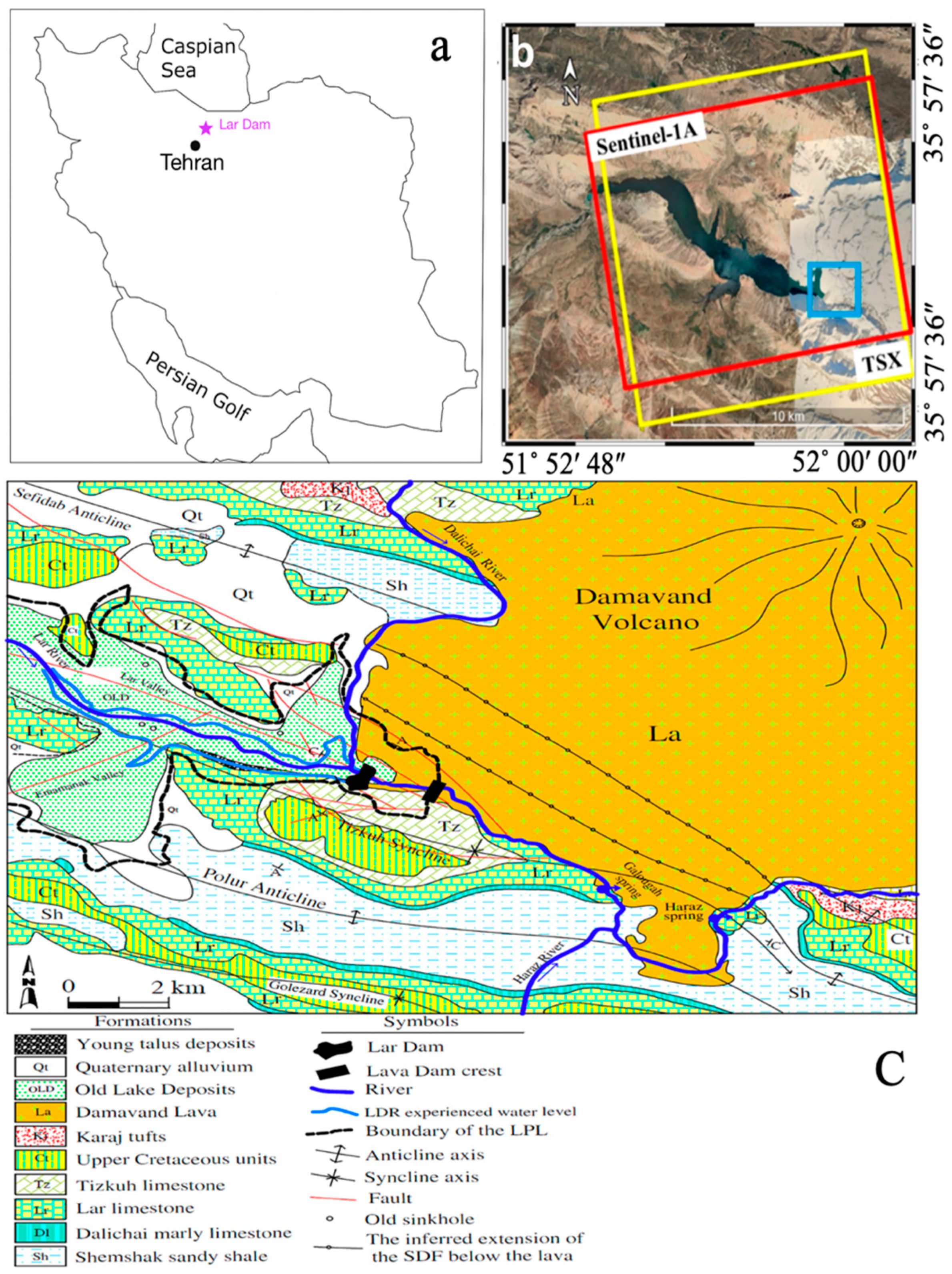
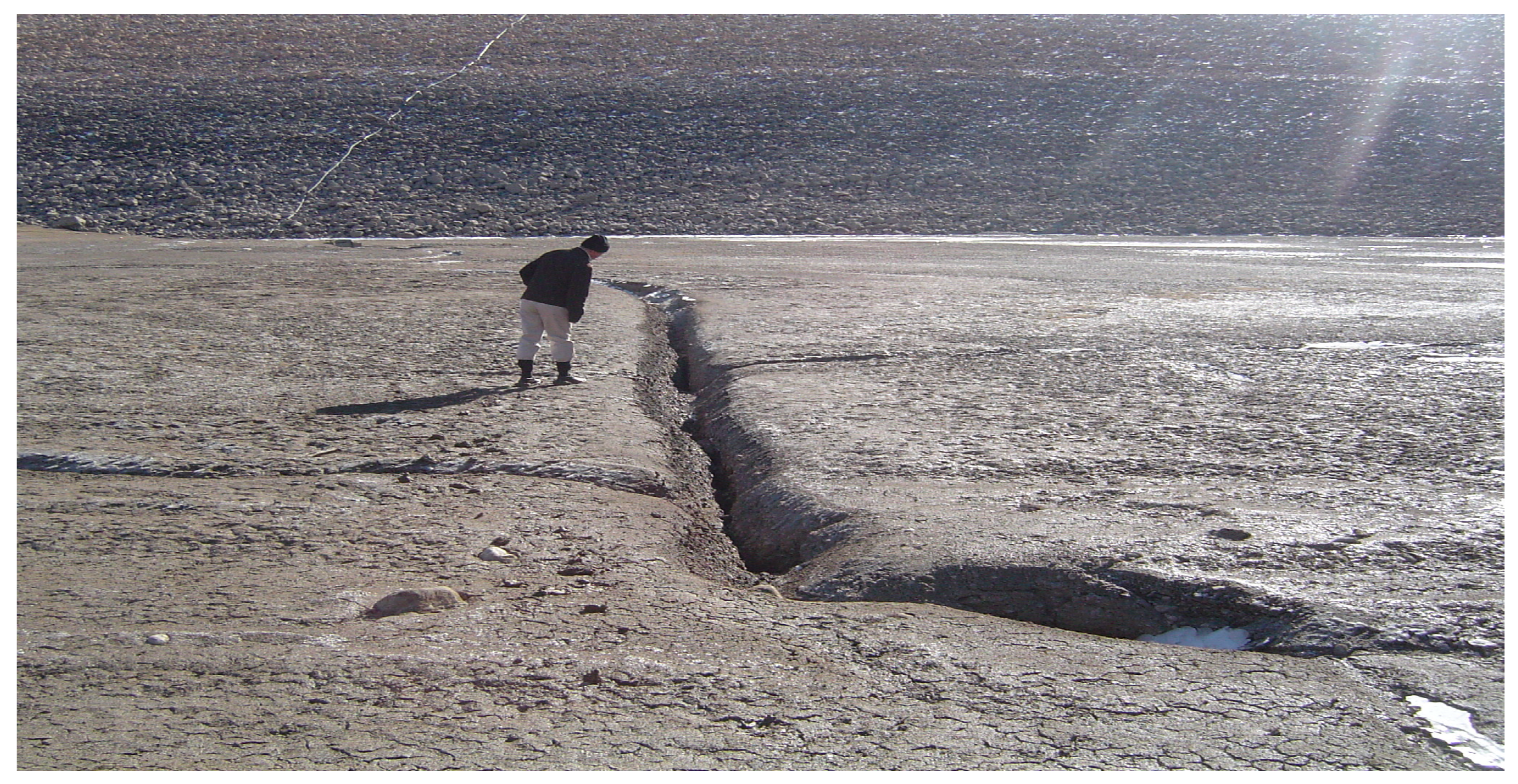
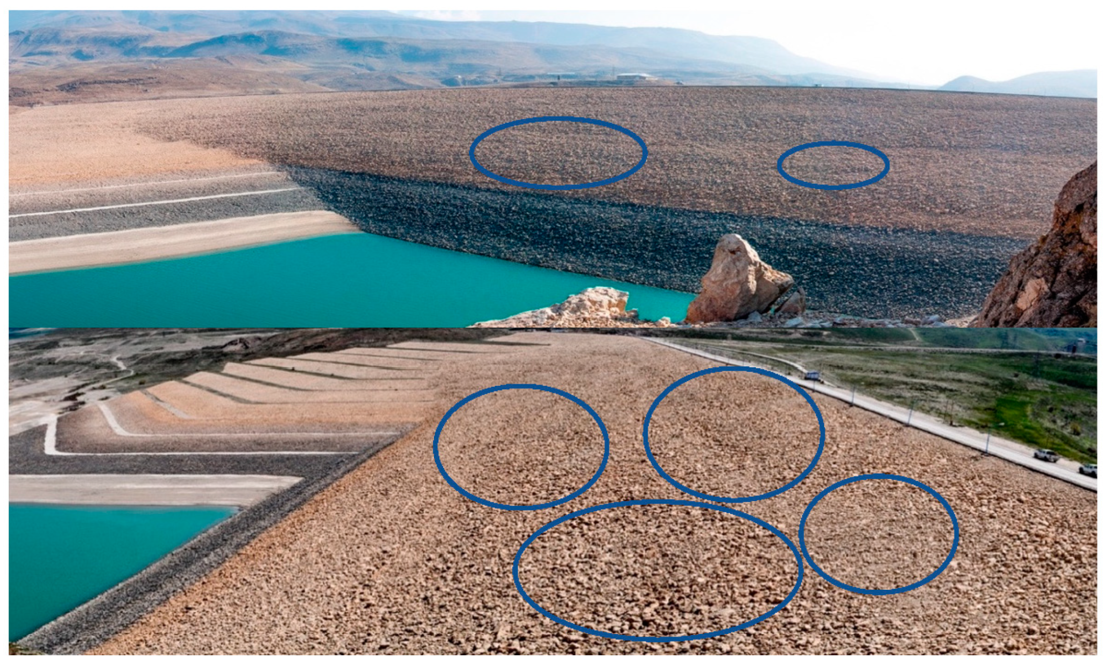
2. Case Study
3. Materials and Methods
3.1. InSAR Processing
3.1.1. TerraSAR-X Processing
3.1.2. Sentinel-1 Processing
3.2. Geodetic Data
4. Results
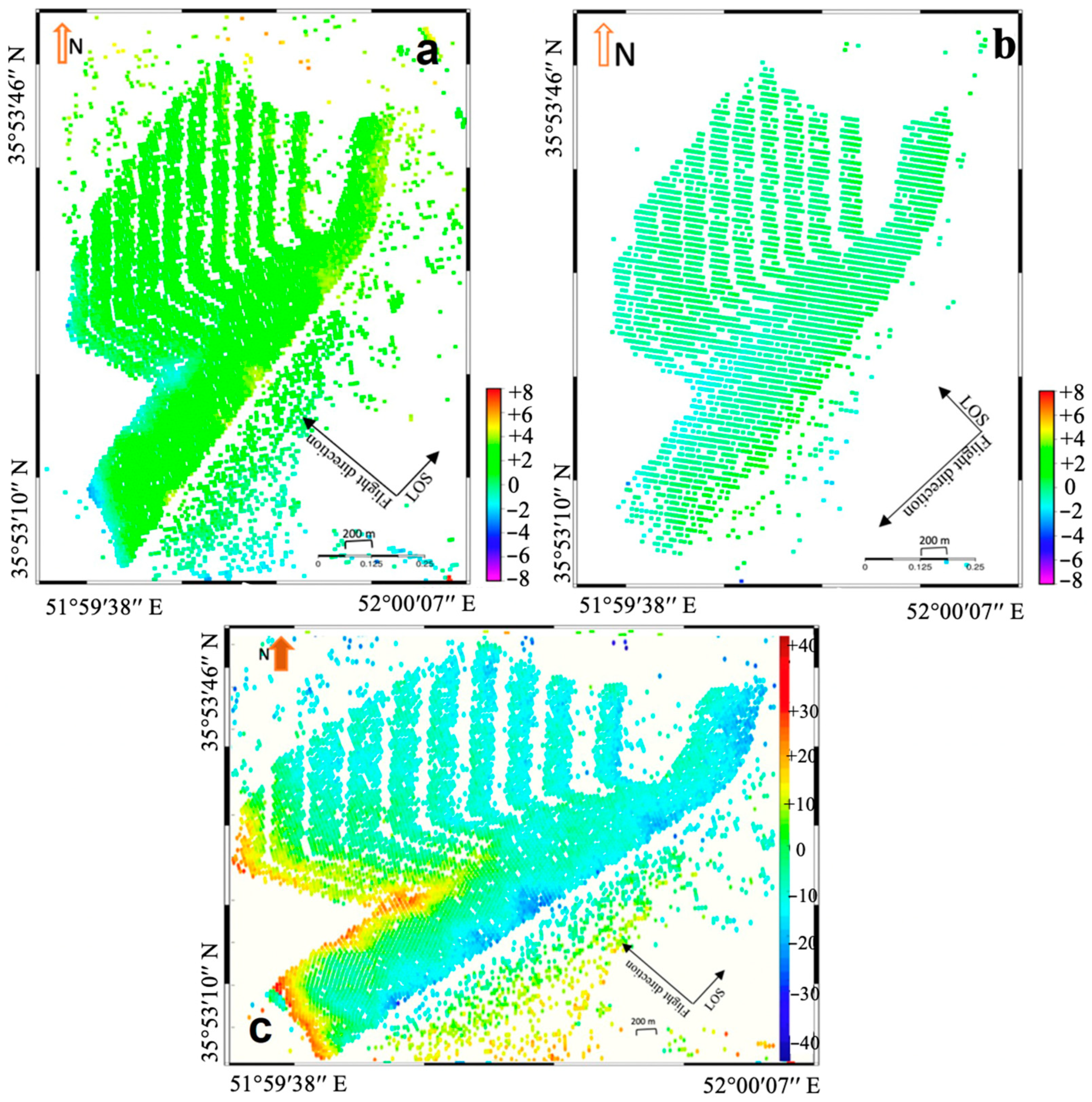
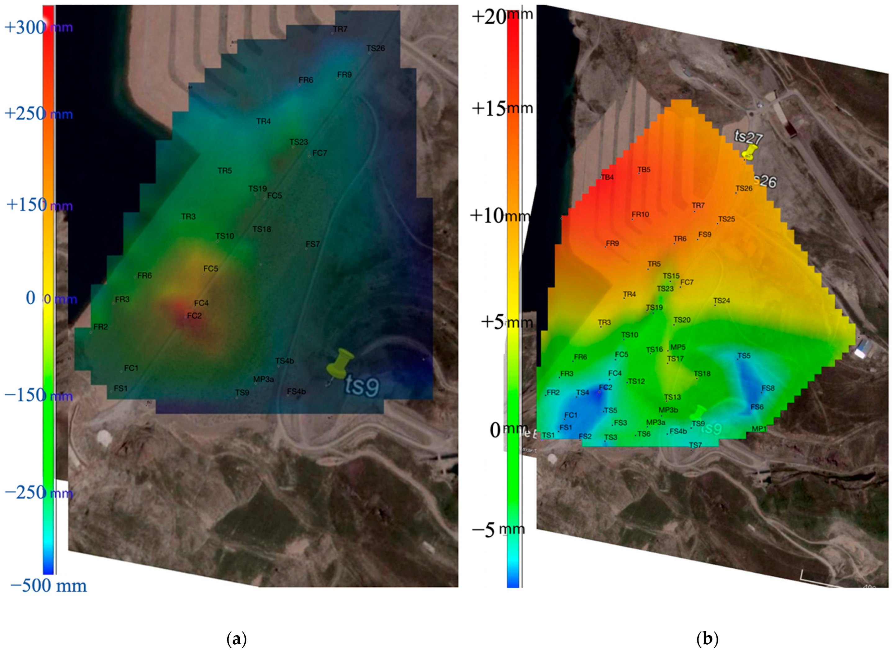
4.1. TerraSAR-X Results
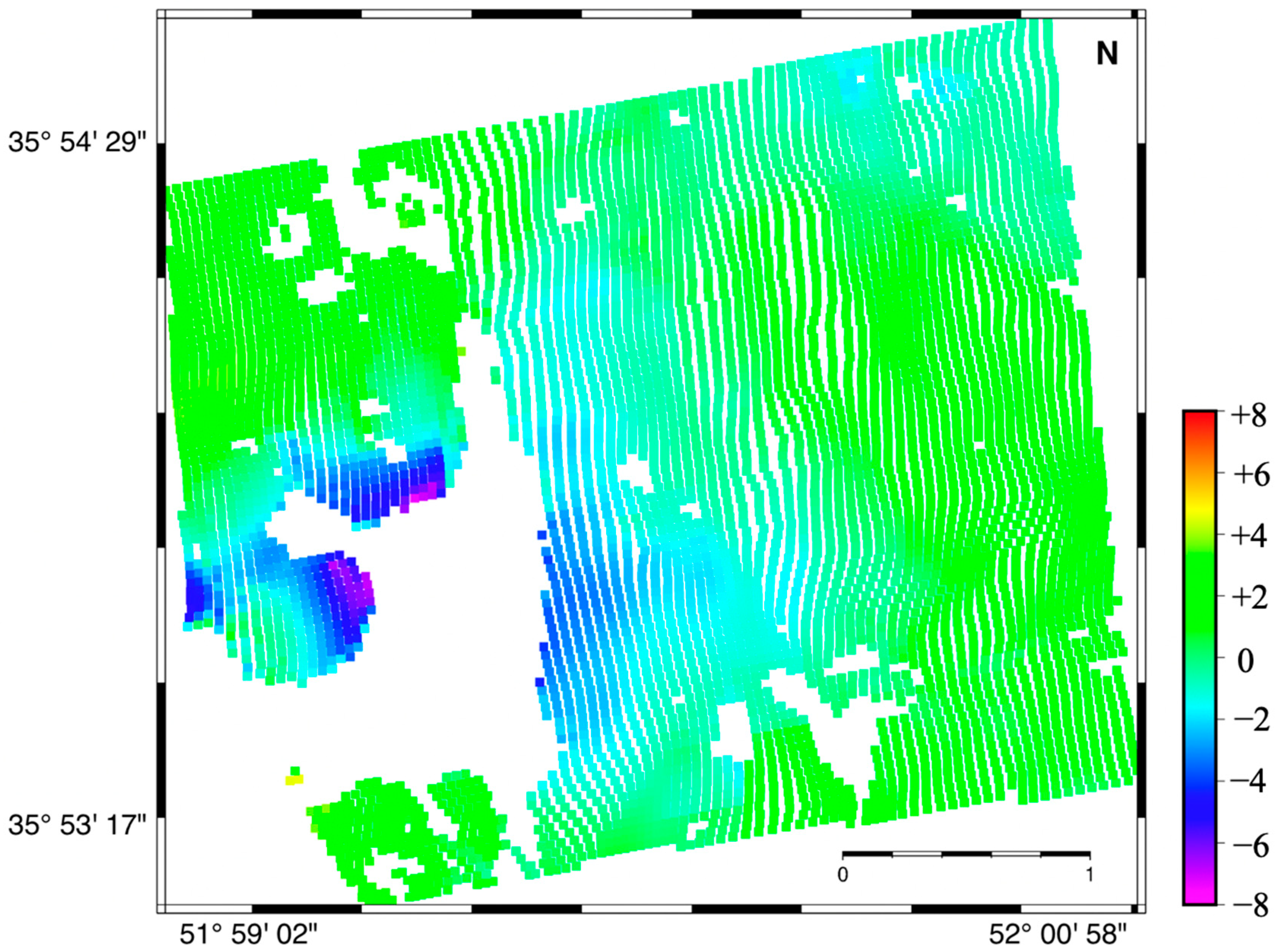
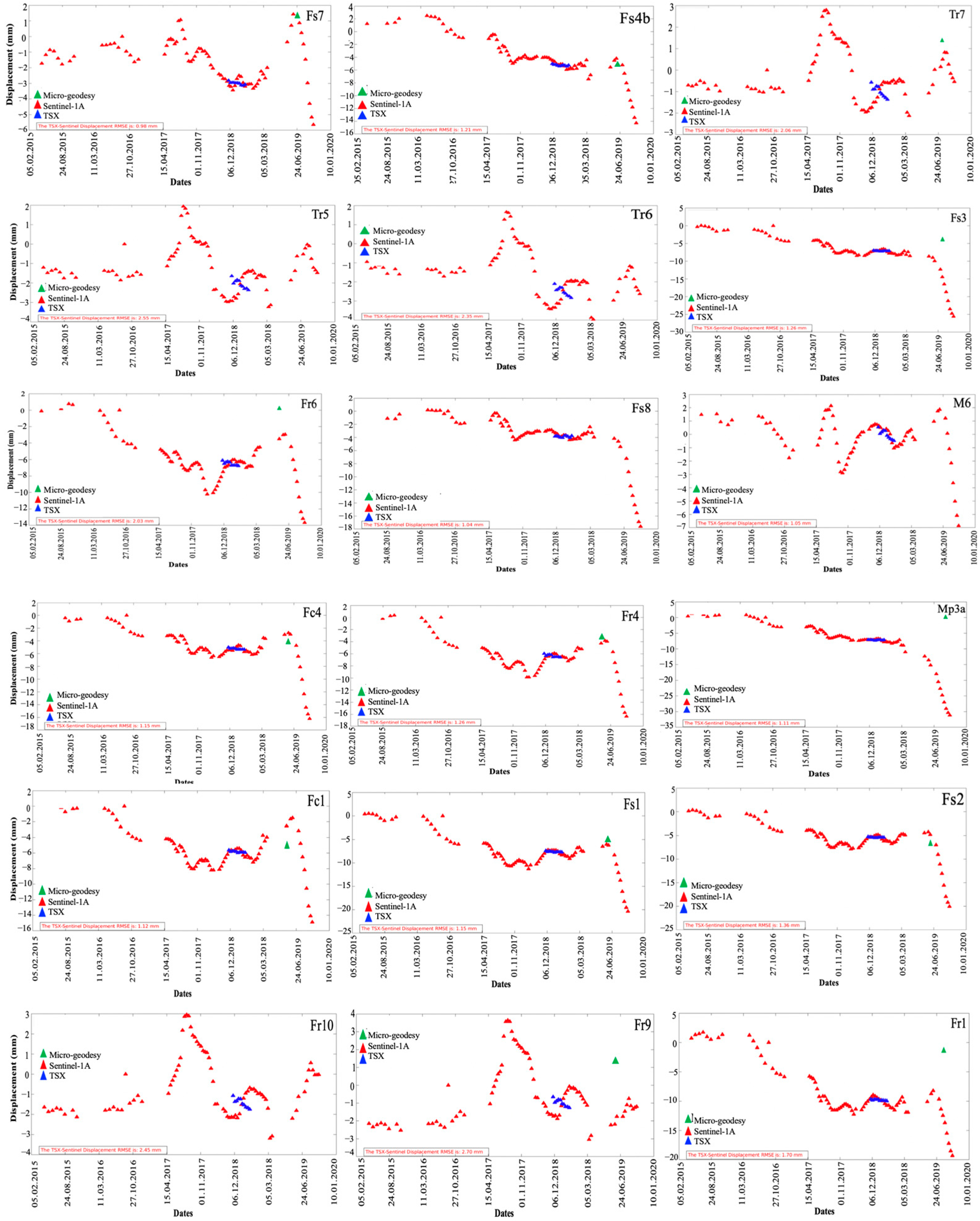
4.2. Sentinel-1A Results
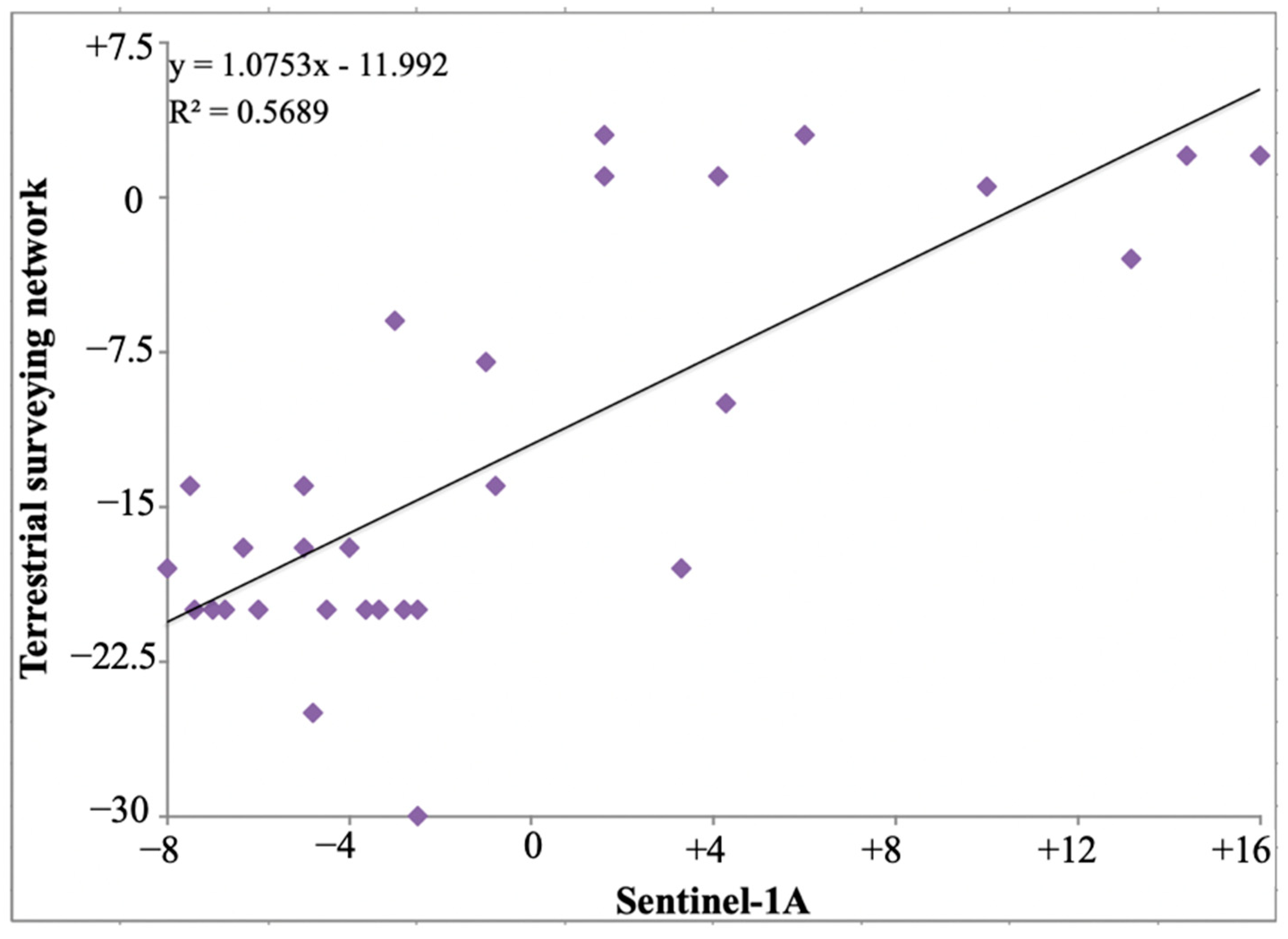
5. Discussion
6. Conclusions
Author Contributions
Funding
Institutional Review Board Statement
Informed Consent Statement
Data Availability Statement
Acknowledgments
Conflicts of Interest
References
- ICOLD World Register of Dams—General Synthesis. 2020. Available online: https://www.icold-cigb.org/ (accessed on 24 March 2024).
- Icold. Dam Failures Statistical Analysis; Int Com Large Dams 99 Bulletin: Tehran, Iran, 1995. [Google Scholar]
- Punia, A. Role of temperature, wind, and precipitation in heavy metal contamination at copper mines: A review. Environ. Sci. Pollut. Res. 2021, 28, 4056–4072. [Google Scholar] [CrossRef] [PubMed]
- Bowles, D.; Brown, A.; Hughes, A.; Morris, M.; Sayers, P.; Topple, A.; Wallis, M.; Gardiner, K. Guide to Risk Assessment for Reservoir Safety Management, Volume 2: Methodology and Supporting Information; Environment Agency: Bristol, UK, 2013; p. 329. [Google Scholar]
- USACE. Guidance for Incorporating Climate Change Impacts to Inland Hydrology in Civil Works Studies, Designs, and Projects 2016; USACE: Washington, DC, USA, 2016.
- Wu, M.; Ye, Y.; Hu, N.; Wang, Q.; Tan, W. Scientometric analysis on the review research evolution of tailings dam failure disasters. Environ. Sci. Pollut. Res. 2023, 30, 13945–13959. [Google Scholar] [CrossRef] [PubMed]
- Berardino, P.; Fornaro, G.; Lanari, R.; Sansosti, E. A new algorithm for surface deformation monitoring based on small baseline differential SAR interferograms. IEEE Trans. Geosci. Remote Sens. 2002, 40, 2375–2383. [Google Scholar] [CrossRef]
- Navalgund, R.R.; Jayaraman, V.; Roy, P.S. Remote sensing applications: An overview. Curr. Sci. 2007, 1747–1766. [Google Scholar]
- Wang, Y.; Bai, Z.; Zhang, Y.; Qin, Y.; Lin, Y.; Li, Y.; Shen, W. Using TerraSAR X-band and sentinel-1 C-band SAR interferometry for deformation along Beijing-Tianjin intercity railway analysis. IEEE J. Sel. Top. Appl. Earth Obs. Remote Sens. 2021, 14, 4832–4841. [Google Scholar] [CrossRef]
- Bouali, E.H.; Oommen, T.; Escobar-Wolf, R. Mapping of slow landslides on the Palos Verdes Peninsula using the California landslide inventory and persistent scatterer interferometry. Landslides 2018, 15, 439–452. [Google Scholar] [CrossRef]
- Mouat, D.A.; Mahin, G.G.; Lancaster, J. Remote sensing techniques in the analysis of change detection. Geocarto Int. 1993, 8, 39–50. [Google Scholar] [CrossRef]
- Bayrak, T. Verifying pressure of water on dams, a case study. Sensors 2008, 8, 5376–5385. [Google Scholar] [CrossRef] [PubMed]
- Di Pasquale, A.; Nico, G.; Pitullo, A.; Prezioso, G. Monitoring strategies of earth dams by ground-based radar interferometry: How to extract useful information for seismic risk assessment. Sensors 2018, 18, 244. [Google Scholar] [CrossRef]
- Mishra, S.; Shrivastava, P.; Dhurvey, P. Change detection techniques in remote sensing: A review. Int. J. Wirel. Mob. Commun. Ind. Syst. 2017, 4, 1–8. [Google Scholar] [CrossRef]
- Tarchi, D.; Rudolf, H.; Luzi, G.; Chiarantini, L.; Coppo, P.; Sieber, A.J. SAR interferometry for structural changes detection: A demonstration test on a dam. In Proceedings of the IEEE 1999 International Geoscience and Remote Sensing Symposium. IGARSS’99 (Cat. No.99CH36293), Hamburg, Germany, 28 June–2 July 1999; Volume 3, pp. 1522–1524. [Google Scholar]
- Ullo, S.L.; Addabbo, P.; Di Martire, D.; Sica, S.; Fiscante, N.; Cicala, L.; Angelino, C.V. Application of DInSAR technique to high coherence Sentinel-1 images for dam monitoring and result validation through in situ measurements. IEEE J. Sel. Top. Appl. Earth Obs. Remote Sens. 2019, 12, 875–890. [Google Scholar] [CrossRef]
- Ghadimi, M. Investigation of riprap stability of a dam: Risk assessment by InSAR method and rock mechanical test. Geomat. Nat. Hazards Risk 2022, 13, 1441–1456. [Google Scholar] [CrossRef]
- Perissin, D. Interferometric SAR multitemporal processing: Techniques and applications. In Multitemporal Remote Sensing; Springer: Berlin/Heidelberg, Germany, 2016; pp. 145–176. [Google Scholar]
- Barzaghi, R.; Cazzaniga, N.E.; De Gaetani, C.I.; Pinto, L.; Tornatore, V. Estimating and Comparing Dam Deformation Using Classical and GNSS Techniques. Sensors 2018, 18, 756. [Google Scholar] [CrossRef]
- Casaca, J.; Braz, N.; Conde, V. Combined adjustment of angle and distance measurements in a dam monitoring network. Surv. Rev. 2015, 47, 181–184. [Google Scholar] [CrossRef]
- Scaioni, M.; Marsella, M.; Crosetto, M.; Tornatore, V.; Wang, J. Geodetic and Remote-Sensing Sensors for Dam Deformation Monitoring. Sensors 2018, 18, 3682. [Google Scholar] [CrossRef]
- de Lacy, M.C.; Ramos, M.I.; Gil, A.J.; Franco, Ó.D.; Herrera, A.M.; Avilés, M.; Domínguez, A.; Chica, J.C. Monitoring of vertical deformations by means high-precision geodetic levelling. Test case: The Arenoso dam (South of Spain). J. Appl. Geod. 2017, 11, 31–41. [Google Scholar] [CrossRef]
- Vázquez-Ontiveros, J.R.; Ruiz-Armenteros, A.M.; de Lacy, M.C.; Gaxiola-Camacho, J.R.; Anaya-Díaz, M.; Vázquez-Becerra, G.E. Risk Evaluation of the Sanalona Earthfill Dam Located in Mexico Using Satellite Geodesy Monitoring and Numerical Modeling. Remote Sens. 2023, 15, 819. [Google Scholar] [CrossRef]
- Uromeihy, A. The Lar Dam; an example of infrastructural development in a geologically active karstic region. J. Asian Earth Sci. 2000, 18, 25–31. [Google Scholar] [CrossRef]
- Mozafari, M.; Raeisi, E. Leakage paths at the Lar Dam site, northern Iran. Q. J. Eng. Geol. Hydrogeol. 2017, 50, 444–453. [Google Scholar]
- Djalaly, H. Remedial and watertightening works of Lar Dam. In Seizieme Congres das Grandes Barages; Geological Society: San Francisco, CA, USA, 1988; Volume 50, pp. 444–453. [Google Scholar] [CrossRef]
- Feghhi, K.; Berga, L.; Buil, J.M. Contribution of the Lar Dam—Polur lineament in the Lar Dam leakage. In Dams and Reservoirs, Society and Environment in the 21st Century; Taylor & Francis London: Abingdon, UK, 2006; pp. 699–706. [Google Scholar]
- Partners, G. Setec Report. Report. 1980. Available online: https://inter.setec.fr/en/about-us/the-setec-group/ (accessed on 24 March 2024).
- Gibbs, A.; Gaborone, P. Dam Raising. Report. 1980. Available online: https://nora.nerc.ac.uk/id/eprint/14632/ (accessed on 24 March 2024).
- Reginal Water Company of Iran Behavior report of the Lar Dam; Bulletin: Tehran, Iran, 2012.
- Ferretti, A.; Prati, C.; Rocca, F. Permanent scatterers in SAR interferometry. IEEE Trans. Geosci. Remote Sens. 2001, 39, 8–20. [Google Scholar] [CrossRef]
- Hooper, A.; Zebker, H.A. Phase unwrapping in three dimensions with application to InSAR time series. JOSA A 2007, 24, 2737–2747. [Google Scholar] [CrossRef] [PubMed]
- Hooper, A. A Statistical-Cost Approach to Unwrapping the Phase of InSAR Time Series. In Proceedings of the International Workshop on ERS SAR Interferometry; Frascati, Italy, 2010. Available online: https://www.researchgate.net/profile/AndyHooper2/publication/228898559_A_Statistical-Cost_Approach_to_Unwrapping_the_Phase_of_InSAR_Time_Series/links/00b7d52f823caae461000000/A-Statistical-Cost-Approach-to-Unwrapping-the-Phase-of-InSAR-Time-Series.pdf (accessed on 24 March 2024).
- Hooper, A. A multi-temporal InSAR method incorporating both persistent scatterer and small baseline approaches. Geophys. Res. Lett. 2008, 35, 16. [Google Scholar] [CrossRef]
- Hanssen, R.F. Radar Interferometry: Data Interpretation and Error Analysis; Springer Science & Business Media: Berlin/Heidelberg, Germany, 2001; Volume 2. [Google Scholar]
- Sandwell, D.; Mellors, R.; Tong, X.; Wei, M.; Wessel, P. Open Radar Interferometry Software for Mapping Surface Deformation; Wiley Online Library: Hoboken, NJ, USA, 2011. [Google Scholar]
- Wessel, P.; Smith, W.H.F.; Scharroo, R.; Luis, J.; Wobbe, F. Generic mapping tools: Improved version released. Eos, Trans. Am. Geophys. Union 2013, 94, 409–410. [Google Scholar] [CrossRef]
- Prats-Iraola, P.; Scheiber, R.; Marotti, L.; Wollstadt, S.; Reigber, A. TOPS interferometry with TerraSAR-X. IEEE Trans. Geosci. Remote Sens. 2012, 50, 3179–3188. [Google Scholar] [CrossRef]
- Gao, M.; Gong, H.; Li, X.; Chen, B.; Zhou, C.; Shi, M.; Guo, L.; Chen, Z.; Ni, Z.; Duan, G. Land subsidence and ground fissures in Beijing capital international airport (bcia): Evidence from quasi-ps insar analysis. Remote Sens. 2019, 11, 1466. [Google Scholar] [CrossRef]
- Fornaro, G.; Pauciullo, A.; Reale, D.; Verde, S. Multilook SAR tomography for 3-D reconstruction and monitoring of single structures applied to COSMO-SKYMED data. IEEE J. Sel. Top. Appl. Earth Obs. Remote Sens. 2014, 7, 2776–2785. [Google Scholar] [CrossRef]
- Wu, S.; Yang, Z.; Ding, X.; Zhang, B.; Zhang, L.; Lu, Z. Two decades of settlement of Hong Kong International Airport measured with multi-temporal InSAR. Remote Sens. Environ. 2020, 248, 111976. [Google Scholar] [CrossRef]


| Type of Dam | Embankment |
|---|---|
| Year of completion | 1980 |
| Dam height above foundation (m) | 107 |
| Height from riverbed (m) | 105 |
| Dam crest width (m) | 13 |
| Dam crest length (m) | 1170 |
| Total water surface area of the reservoir (Km2) | 33.5 |
| Reservoir width (Km) | 1–6 |
| Reservoir length (Km) | 18 |
| Total reservoir volume | 960 |
| Temporal Coverage | Orbit | Mode | Resolution (m) | Size | Incidence Angle | Heading Angle | Band |
|---|---|---|---|---|---|---|---|
| 9.5.2018–16.8.2018 | Descending | Spotlight | 1 | 10 × 5 | 34.3 | 350 | X |
| 10.5.2018–17.8.2018 | Ascending | Spotlight | 1 | 10 × 5 | 32.8 | 190 | X |
| Temporal Coverage | Orbit | Mode | Resolution (m) | Swath (Km) | Incidence Angle | Heading Angle | Band |
|---|---|---|---|---|---|---|---|
| 5 February 2015–30 September 2019 | Ascending | IW | 20 × 5 | 250 | 34.3 | 32.3 | C |
| Point Name | (mm) | (mm) | D (mm) | Az (deg) | a (mm) | b (mm) | Phi (deg) |
|---|---|---|---|---|---|---|---|
| M5 (2013–2019) | −1.34 | −1.68 | 2.15 | 218 | 1 | 0.9 | 16 |
| M5 (1992–2019) | 3.4 | 2.65 | 4.31 | 52 | 0.8 | 0.8 | 14 |
| M6 (2013–2019) | 3.02 | −0.33 | 3.03 | 96 | 1.2 | 0.9 | 117 |
| M6 (1992–2019) | −2.49 | −4.54 | 5.18 | 208 | 1 | 0.9 | 120 |
| M1 (2013–2019) | 3.79 | 4.7 | 6.04 | 39 | 1 | 0.9 | 165 |
| M1 (1992–2019) | −4.31 | −6.19 | 7.54 | 215 | 0.9 | 0.8 | 31 |
| M4 (2013–2019) | −1.88 | −2.25 | 2.93 | 219 | 1 | 0.8 | 23 |
| M4 (1992–2019) | 4.55 | 5.27 | 6.96 | 40 | 0.8 | 0.8 | 10 |
| M2 (2013–2019) | 0.17 | 4.27 | 4.28 | 2 | 1 | 0.9 | 149 |
| M2 (1992–2019) | −4.71 | −5.69 | 7.39 | 219 | 0.9 | 0.8 | 20 |
| M3 (2013–2019) | −3.76 | −4.71 | 6.03 | 218 | 1.2 | 0.9 | 45 |
| M3 (1992–2019) | 3.57 | 8.5 | 9.22 | 22 | 1 | 0.8 | 42 |
| Vertical Status | Point Name | Vertical Status | Point Name | ||||||||
|---|---|---|---|---|---|---|---|---|---|---|---|
| 2013–2019 | 1992–2013 | 2013–2019 | 1992–2013 | ||||||||
| Moved | 3/9 | −7.41 | 5.2 | −43.26 | FC1b | Fixed | 0.0 | 0.00 | 0.0 | 0.00 | L39 |
| Moved | 3/9 | −6/73 | 5.2 | −38.13 | FS1b | Not Moved | 0.3 | −0.13 | 0.3 | 0.19 | L38 |
| Moved | 3.7 | 14.39 | 5.0 | −9.12 | TR7b | Moved | 3.5 | 10.79 | 4.7 | −13.49 | TS26b |
| Moved | 3/8 | 13/17 | 5.1 | −14.08 | TR6b | Moved | 3.6 | 11.59 | 4.9 | −12.00 | TS25b |
| Moved | 3/9 | 10/36 | 5.1 | −23.09 | TR5b | Moved | 4/1 | −4/55 | 5.0 | −24.04 | FS9b |
| Moved | 3.9 | 7.11 | 5.2 | −47.82 | TR4b | Moved/not moved | 3.8 | 1.51 | 5.1 | −39.08 | FC7b |
| Moved | 3.9 | 4.19 | 5.2 | −54.71 | TR3b | Moved | 3.8 | 3.59 | 5.2 | −53.82 | TS19b |
| Moved | 3.9 | −0.79 | 5.2 | −61.68 | FR6b | Moved | 3.9 | 3.12 | 5.2 | −53.66 | FC6b |
| Moved | 3/9 | −4/07 | 5.2 | −68.03 | FR4b | Moved | 3.9 | 0.74 | 5.2 | −62.00 | TS15b |
| Moved | 3/9 | −5/27 | 5.2 | −60.80 | FR2b | Moved | 3.9 | −1.1 | 5.2 | −193.01 | FC5b |
| Moved | 3/9 | −3/21 | 5.2 | −28.53 | FR1b | Moved | 3.9 | −2.95 | 5.2 | −66.96 | TS10b |
| Moved | 3/9 | −7/34 | 5.2 | −32.07 | FS2b | Moved | 3.9 | −6.15 | 5.2 | −200.61 | FC4b |
| Moved/not moved | 3/9 | −3/35 | 5.2 | −15.00 | TS3b | Moved | 3.9 | −7.49 | 5.2 | −457.81 | FC3b |
| Moved | 3/9 | −4/79 | 5.3 | −25.60 | FS3b | Moved | 3.9 | −8.25 | 5.2 | −153.45 | FC2b |
| Moved | 3/9 | −4/65 | 5.2 | −32.30 | FS4b | Moved | 3.9 | −7.17 | 5.2 | −72.87 | TS4b |
| Moved | 4/0 | 16/18 | 5.4 | −19.43 | FR10b | Moved/not moved | 3/9 | 2/64 | 5.3 | −27.53 | MP5 |
| Moved/not moved | 4/0 | −2/55 | 5.3 | −18.59 | MP3A | Moved/not moved | 3/9 | −1/57 | 5.2 | −35.32 | FS7b |
| Moved | 4.1 | −2.97 | 5.5 | −9.48 | MP1 | Moved | 4/0 | 1/1 | 5.3 | −6.66 | TS13b |
| Moved | 3/9 | −3/73 | 5.3 | −18.56 | TS1b | Moved | 3/9 | −2/47 | 5.3 | −18.94 | MP3b |
| Moved/not moved | 4/0 | −3.05 | 5.3 | −15.64 | TS6b | Moved/not moved | 3/9 | −3/47 | 5.3 | −30.94 | MP4 |
| Moved | 4/0 | 3/4 | 5.4 | 4.03 | FS8c | Moved | 3/9 | −0/05 | 5.3 | −47.46 | TS16b |
| Moved | 3/9 | 1/67 | 5.3 | −35.78 | FS7c | Moved | 4/1 | −5/55 | 5.5 | −16.71 | TS7b |
| Moved/not moved | 3/9 | −5/63 | 5.3 | −30.70 | FS2c | Moved | 4/1 | −4/55 | 5.5 | −15.24 | TS9b |
| Moved | 4/1 | −4/89 | 5.5 | −13.11 | FS4Bc | Moved | 3/9 | −4/65 | 5.5 | −10.03 | FS4Bb |
| Moved/not moved | 3/9 | −6/89 | 5.3 | −50.29 | FC1c | Moved | 4/0 | 3/29 | 5.4 | 1.54 | FS8b |
| Moved | 3/9 | −5/07 | 5.3 | −50.51 | FC4c | Moved | 4/0 | −3/05 | 5.5 | −1.24 | FS6b |
| Moved/not moved | 3/9 | 4/88 | 5.2 | −51.70 | FC6c | Moved/not moved | 3/9 | 0/33 | 5.3 | −40.09 | FC5c |
| Moved | 4/1 | 15/42 | 5.5 | −12.35 | FR9b | Moved | 3/7 | 10/15 | 4.8 | 5.23 | M2 |
| Moved/not moved | 4/3 | 0/96 | 5.8 | 14.5 | M3 | ||||||
| Moved | 4/0 | 4/27 | 5.4 | 8.80 | M6 | ||||||
| Pillar Point | Terrestrial Surveying Result (mm) | Sentinel-1A (mm) | Pillar Point | Terrestrial Surveying Result (mm) | Sentinel-1A (mm) |
|---|---|---|---|---|---|
| Ts13 | +6 | +3 | Fs4b | −5 | −14 |
| M2 | +10 | +0.5 | Tr6 | +13.17 | −3 |
| Fc3 | −6.33 | −17 | Fs2 | −6 | −20 |
| Fc4 | −5 | −17 | Fr1 | −2.8 | −20 |
| Fc5 | −1 | −8 | Tr7 | 14.39 | +2 |
| Fc2 | −8 | −18 | Fs3 | −4.8 | −25 |
| Ts4 | −7 | −20 | Ts1 | −3.64 | −20 |
| Fr4 | −4 | −17 | Mp3b | −2.5 | −20 |
| Ts10 | −3 | −6 | Mp3a | −2.5 | −30 |
| Fc1 | −7.5 | −14 | Fr6 | −0.79 | −14 |
| Fr10 | +16 | +2 | Ts3 | −3.35 | −20 |
| Fs7 | +1.6 | +3 | Ts9 | −4.5 | −20 |
| Tr5 | +4.1 | +1 | Fs8 | +3.29 | −18 |
| Fs1 | −6.73 | −20 | M6 | +4.27 | −10 |
| Fr9 | +1.6 | +1 | Fs6 | −7.4 | −20 |
Disclaimer/Publisher’s Note: The statements, opinions and data contained in all publications are solely those of the individual author(s) and contributor(s) and not of MDPI and/or the editor(s). MDPI and/or the editor(s) disclaim responsibility for any injury to people or property resulting from any ideas, methods, instructions or products referred to in the content. |
© 2024 by the authors. Licensee MDPI, Basel, Switzerland. This article is an open access article distributed under the terms and conditions of the Creative Commons Attribution (CC BY) license (https://creativecommons.org/licenses/by/4.0/).
Share and Cite
Ghadimi, M.; Kiani, M. Deformation Risk Assessment of the Lar Dam: Monitoring Its Stability Condition. Sustainability 2024, 16, 4335. https://doi.org/10.3390/su16114335
Ghadimi M, Kiani M. Deformation Risk Assessment of the Lar Dam: Monitoring Its Stability Condition. Sustainability. 2024; 16(11):4335. https://doi.org/10.3390/su16114335
Chicago/Turabian StyleGhadimi, Mehrnoosh, and Mohammadali Kiani. 2024. "Deformation Risk Assessment of the Lar Dam: Monitoring Its Stability Condition" Sustainability 16, no. 11: 4335. https://doi.org/10.3390/su16114335