Communication

Evaluating an Innovative ICT System for Monitoring Small-Scale Forest Operations: Preliminary Tests in Mediterranean Oak Coppices

1
Department of Agriculture and Forest Science, University of Tuscia, Via San Camillo de Lellis, 01100 Viterbo, Italy
2
Consiglio per la Ricerca in Agricoltura e l’Analisi dell’Economia Agraria, Centro di Ricerca Ingegneria e Trasformazioni Alimentari, Via della Pascolare 16, 00015 Monterotondo, Italy
3
Institute of Dendrology, Polish Academy of Sciences, Parkowa 5, 62-035 Kórnik, Poland
*
Author to whom correspondence should be addressed.
Sustainability 2024, 16(11), 4629; https://doi.org/10.3390/su16114629
Submission received: 22 April 2024 / Revised: 27 May 2024 / Accepted: 28 May 2024 / Published: 29 May 2024
(This article belongs to the Special Issue Forest Operations and Sustainability)

Abstract

:
The application of modern technologies to increase the overall sustainability of forest operations is known as precision forest harvesting. Precision forest harvesting can be a very powerful tool; however, it requires modern forest machinery, which is expensive. Given that most of the forest operators in the Mediterranean area are small-scale businesses, they do not have the resources to purchase costly equipment; thus, the application of precision forest harvesting is affected. Bearing this in mind, in this study, we aimed to test the accuracy of the GNSS receiver on which an innovative Information and Communication Technology (ICT) system developed to monitor small-scale forest operations is based. We tested the GNSS’s accuracy by comparing the extraction routes recorded during coppicing interventions in two forest sites located in Central Italy with those obtained with a more high-performing GNSS receiver. We also used linear mixed-effects models (LMMs) to investigate the effects on the GNSS positioning error of topographic features, such as the slope, elevation, aspect and Topographic Position Index (TPI). We found that the average positioning error was about 2 m, with a maximum error of about 5 m. The LMMs showed that the investigated topographic features did not significantly affect the positioning error and that the GNSS accuracy was strongly related to the specific study area that we used as a random effect in the model (marginal coefficient of determination was about 0.13 and conditional coefficient of determination grew to about 0.59). As a consequence of the negligible canopy cover after coppicing, the tested GNSS receiver achieved satisfactory results. It could therefore be used as a visualising tool for a pre-planned extraction route network, allowing the operator to follow it on the GNSS receiver screen. However, these results are preliminary and should be further tested in more experimental sites and various operational conditions.

1. Introduction

One of the most important things to take into account in the effort to achieve Sustainable Forest Management (SFM) [1,2,3,4,5], a primary goal of the European Forest Strategy [6], is the implementation of Sustainable Forest Operations (SFOs) [7,8,9]. The term “SFOs” refers to the use of logging techniques that have reasonable costs, have minimal environmental effects, and guarantee worker safety [10,11]. Precision forestry is defined as the use of contemporary technology, including Information and Communication Technology (ICT), Geographic Information Systems (GISs), Global Navigation Satellite Systems (GNSSs), Unmanned Aerial Vehicles (UAVs), and a variety of sensors, to enhance the overall sustainability of forest management [12,13,14]. It is one of the most powerful tools for addressing the target of Sustainable Forest Management [15,16,17].
The term “precision forestry” refers to an interdisciplinary and transdisciplinary idea that allows for the creative application of cutting-edge technology in specific forest sector situations [18]. There are many uses for various smart technologies within the context of precision forestry, given the high degree of multidisciplinarity that characterises the forest sector. When performing forest inventories, satellites or unmanned aerial vehicles (UAVs) can be used to measure the aboveground biomass [19,20,21] and track pests and drought [22,23,24]. Geographic Information Systems (GISs) can be used to plan harvesting operations in a variety of ways, such as choosing the best extraction technology [25,26], designing skid trail networks that are optimised in advance [27,28,29], or creating maps of soil trafficability [30,31,32,33].
Monitoring harvesting operations is another function that cutting-edge and intelligent technologies may carry out within the context of precision forestry. When a fully mechanised harvesting system with state-of-the-art machinery is used, some data on the machine functioning and the features of the harvested wooden material can be obtained, such as the dendrometric features, species, or location [34]. Additionally, data, including the fuel consumption, productivity, and position, can be seen remotely through the manufacturer’s portal. The Controller Area Network (CAN-bus) system, which is implemented in nearly all modern forest harvesters and processors, makes all these applications realisable by transmitting the machine status and the parameters to the on-board computer (OBC) via the Standard for Forest Machine Data and Communication (StanForD) [35,36].
However, these systems are only available on modern forest machines. Nonetheless, it is very important to develop systems that are just as efficient and effective at a cost that is feasible for small-scale forest business. Small-scale forest businesses make up the majority of those operating on the territory in several modern countries, including Italy [37]. To the best of our knowledge, no scientific paper has focused on the development of a system to monitor forest operations within the context of small-scale forestry. Small-scale forestry is defined as forest operations carried out by small or medium enterprises. These businesses typically use machinery that is not specifically developed for forestry. Most of the machinery used by these businesses is machinery originally purposed for agricultural use, which is adapted for forest work. It is worth noting that the type of agricultural machinery is usually of an old model. There is a previous study that made an effort to find a solution to this issue. A monitoring system was developed for forwarding operations performed by old models of forwarders with no CAN-bus system and for forestry-fitted farm tractors equipped with a trailer [38]. It included a GNSS portable receiver with an Android platform-specific app and a weighing system mounted on the loading deck of the machine to assess the amount of extracted timber in each working cycle. In addition to tracking the working hours and productivity, the system can record the strip road pattern [38]. In this preliminary research, we wanted to address the following question: “Is the GNSS precision of the developed ICT system enough to guide the driver of the machine along a pre-planned strip road network?”.
It is known that the correct functioning of a GNSS system is often hampered in a forest environment [39,40,41]. The use of GNSS in forestry is frequently impacted by a multi-pathing error, which happens when satellite signals are reflected or diffracted by surrounding objects or surfaces or occluded by the canopy or other solid objects. This problem exists even with the application of real-time kinematics correction techniques, which may normally increase the position accuracy, even at a sub-centimetric level, but only in the presence of robust satellite coverage [42,43,44].
Taking all the above into account, we established this research with the goal of testing the efficiency of the previously developed monitoring system for forwarding operations [38], with a particular focus on the level of precision of the GNSS receiver. We tested the system in two operational contexts in Central Italy’s Turkey oak (Quercus cerris L.) coppice forests. We further tried to investigate the effects on the GNSS’s precision of topographical features such as the slope, aspect, elevation, and Topographic Position Index. We also aimed to understand if this system is reliable in the harsh topographic conditions in which forest operations are performed in the context of Mediterranean forestry.

2. Materials and Methods
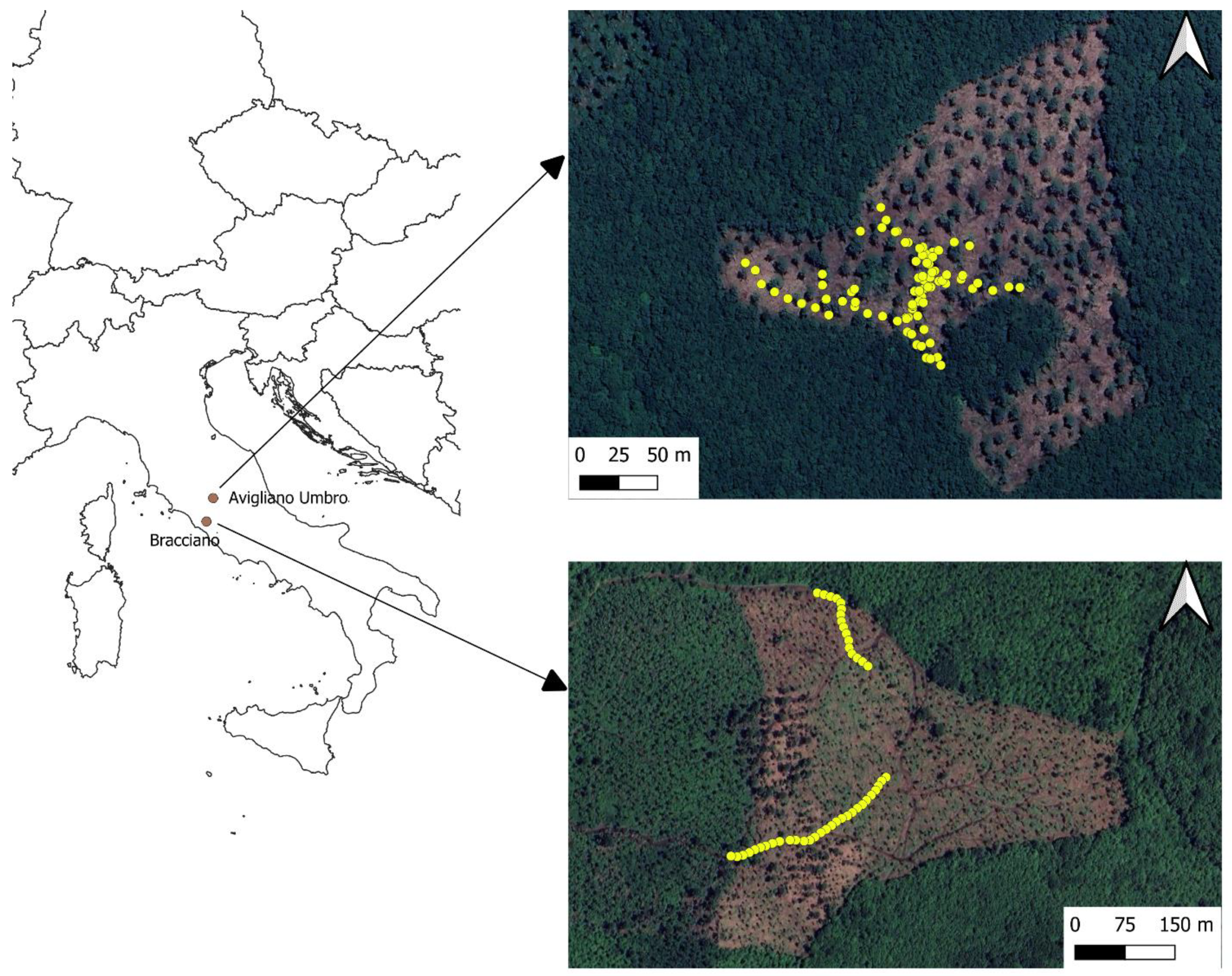
2.1. Study Areas

We selected two forest sites located in Central Italy (Figure 1), one in the municipality of Avigliano Umbro (Umbria, Italy, 777769 E, 4726803 N WGS84UTM32N) and the other in the municipality of Bracciano (Latium, Italy, 761256 E, 4671354 N WGS84UTM32N). The two sites are both Turkey oak coppices harvested in the harvesting season 2022–2023 and are highly representative of oak coppices in Central Italy. The sites were specifically selected because they presented a wide range of slopes (from 0% to almost 30%, representing the upper limit where forwarders are generally applied) and complex topography, thus resulting in optimal testing conditions for our scope. In both the study areas, the forest operations consisted in motor-manual felling and processing by chainsaw and extraction by an old model of forwarder (Avigliano) and forestry-fitted farm tractor equipped with a trailer (Bracciano).

2.2. Field Surveys

A full description of the tested ICT system for monitoring forest operations on forest machines not equipped with a CAN-bus system is reported in [38]. Briefly, it is made up of a weighting system located on the forwarding deck, a GNSS receiver and a dedicated app to record and describe the various working elements. Concerning the GNSS, the system is based on a GNSS Android 4G receiver Mobile Mapper 50 (Spectra Geospatial, Westminster, CO, USA) with a declared GNSS precision up to 1 m. The overall implementation cost of the ICT system ranges from EUR 4000 to 8000, depending on the precision of the installed weighing system and of the performance of the GNSS receiver.
The ICT system has two purposes. Firstly, it records the duration of the work session, then it measures the weight of the timber extracted. The work productivity is calculated automatically. Secondly, it acts as a navigator where a GIS-planned strip road network can be uploaded to the Mobile Mapper 50 software. The driver can visualise and follow the work progress on the screen of the GNSS receiver. At the same time, the ICT system records in .gpx format all the strip roads established by the machine. In our experiment, we did not develop a GIS-planned strip road network, but we allowed the drivers to establish the extraction routes according to their experience. A technical flow chart of the ICT system is reported in Figure 2.
During the harvesting operations in both study areas, the forwarder operator was provided with the ICT system, which recorded all the machine’s movements, thus creating a vector file of the strip road network established for carrying out the extraction operation in each study area.
After the end of the harvesting operations, the created vector files of the strip roads were converted into a point shapefile and uploaded to a more complex and high-performing GNSS receiver, Spectra SP20 (Spectra Geospatial, Westminster, CO, USA), which, thanks to the real-time kinematics correction techniques, can reach a centimetric precision. The Spectra SP20 receiver was equipped with Mobile Mapper 50 software as well.
At this stage, the field surveys started. With the Spectra SP20, one operator identified 85 points located along the strip roads in Avigliano and 45 points located along the strip roads in Bracciano. The operator reached each point and waited 3 min so as to be sure of being in the exact location of the recorded point. Then, the operator used a tape measure to check the distance between the location of the point and the centre of the actual strip road.
In this way, we obtained 130 measurements for the distance between the point along the strip roads recorded by the ICT system and the real location of the strip road. These distances were used as a measure of the error of the ICT GNSS and as dependent variables in the developed models.

2.3. Investigated Terrain Features and Statistical Analysis

To assess the reliability of the ICT system in different operating conditions, we wanted to understand how the topography of the logging site affects the precision of the GNSS receiver. We therefore used a 10 m resolution Digital Elevation Model (DEM) [45,46] to extract the elevation (m a.s.l.) and calculate the terrain slope (%), terrain aspect and Topographic Position Index (TPI) [47,48] in correspondence to the survey points. The Topographic Position Index is a terrain categorisation technique that compares the height of each data point to that of the surrounding points. A point index value will be positive if it is higher than the surrounding area, as on ridges and hilltops, and negative for sunken features such as valleys. All the GIS analyses were carried out using QGIS 3.28 software [49], while the statistical analysis was performed using R software [50].
We used linear mixed-effects models (LMMs) to investigate the effects of the topographical variables on the GNSS error. In the models, we used the positioning error as the dependent variable, the elevation, slope, aspect and TPI as fixed effects, and the study area (Avigliano or Bracciano) as a random effect. A random effect was included to account for the spatial-related data dependency and for the fact that the surveys were carried out on two different days, one per each study area.
We started by fitting a full model with all the dependent variables by using the package lme4 [51], and we checked the Variance Inflation Factor (VIF) to exclude excessive correlation among the fixed-effects with the car package [52]. No variable showed a VIF higher than 10, so we could exclude collinearity among the fixed effects. Subsequently, we used the dredge() function from the MuMin package [53] to select the best model; in particular, we selected the model with the lowest Akaike’s Information Criterion, corrected for the small sample size (AICc). In this way, we developed a further LMM by using only the elevation and TPI as fixed effects. Finally, we used the MuMin package [53] to calculate the marginal coefficient of determination (R2m) and conditional coefficient of determination (R2c), respectively indicating the amount of variance explained by the fixed effects and that explained by both the fixed and random effects [54]. We used the package ggeffects [55] to calculate and visualise the marginal response and marginal means, representing the mean values of a given fixed effect assuming a constant level of all the other predictors and no random effect (global estimate).

3. Results

Descriptive statistics concerning the investigated variables and the GNSS positioning error are reported in Table 1. The average positioning error result was 1.71 m in Avigliano (maximum error 4.80 m) and 2.30 m in Bracciano (maximum error 5.20 m). In both the study areas, the minimum positioning error was practically negligible (0.01 m). Particularly for the Avigliano study area, the slope range covered practically all the slopes where ground-based logging is generally applied by forwarding, ranging from 0% to 25%.
The results of the linear mixed-effects model are shown in Table 2. The standard deviation related to the random effect in the model (study area) was 1.21 m. Both the elevation and TPI did not show a statistically significant influence (p < 0.05) on the GNSS positioning error, while the slope and aspect were even excluded by the final model after checking the AICc. The marginal coefficient of determination R2m was 0.136, which increased to 0.592 when considering the effect of the study area-related random effect. Therefore, it is evident that there is a strong effect of the study area on the GNSS positioning error, which is not explainable by the topography.
The relationship between the GNSS positioning error and the topographic variables is reported graphically in Figure 3A (error vs. elevation) and Figure 3B (error vs. TPI). The regression line for the elevation is negative, while for the TPI it is positive; however, for both variables, the data distribution clearly confirms the lack of influence on the GNSS positioning error, as already highlighted by the results of the model.

4. Discussion

The GNSS is globally recognised as the key tool for positioning an object on the Earth’s surface [56,57,58]. However, it is well known that forests represent a challenging environment for GNSS position accuracy, with positioning errors that generally prove to be two to four times higher than in open areas using the same GNSS receiver [39,59]. The main reason for the decreased GNSS precision in forests is related to the canopy cover, with increasing canopy density generally leading to bigger errors [39]. In our case study, both the operator driving the forwarder and recording the positions with the ICT system and the operator checking its accuracy with the SP20 receiver worked in conditions of negligible canopy cover. This took place after a coppicing intervention releasing about 100 standards per hectare. Therefore, the influence of the canopy on the GNSS receiver accuracy can be excluded. As a result, the positioning errors were on average much lower than what was shown in previous similar studies in forest environments, where the average error was about 2 m and the max error about 5 m (Table 1) [59]. This level of the positioning error is obviously not enough to consider developing an automatic driving system [60], but it is enough to perform a very important task in the framework of sustainable forest operations. Indeed, with this position accuracy, it is possible to use the GIS to pre-plan an optimised strip road network, upload it to the GNSS receiver and allow the operator to visualise it on the screen and follow it, similarly to what happens in modern forest machines [28]. In this way, the operator can avoid zones with excessive slope or areas of soil particularly sensitive to machinery-induced compaction [30].
Previous studies have shown that that topography can have an influence on the GNSS positioning accuracy as well. For instance, Zimbelman and Keefe (2018) found that topographic features can affect the number of signal losses from the GNSS technology paired with radio frequency (RF) transmission (GNSS-RF) [42]. However, the study [42] also found that the positioning error was significantly related to the stand features (proxy of canopy cover) exclusively and not to the terrain features such as the slope, aspect and presence of concave. Our results confirmed these findings. Indeed, we did not reveal any significant effect for any of the investigated terrain features, with the slope and aspect even being excluded from the final model, and the TPI and elevation showing non-significant results (Table 2, Figure 3). This means that the system can be used in the target operational context (Mediterranean forestry) without being affected by the topographic features of the forest site.
Furthermore, it is worth noting that the developed ICT system is applicable in any small-scale forestry operations in which timber extraction is carried out by forwarding; that is to say, by using a loading deck. Being based on a weighing system, a GNSS receiver and a specific app, it can be installed on any machine equipped with a loading deck used for forest operations.
Obviously, our study presents some limitations. First of all, it should be observed that this paper can be considered a preliminary study. In fact, the test that was carried out was a preliminary one, taking into consideration only two study areas and both referring to one forest typology (oak coppice), although it was highly representative of the typical working conditions of forwarding extractions after coppicing in oak forests. It is interesting to note how the model’s coefficient of determination grew substantially when including the effect of the study area (R2c 0.59 vs. R2m 0.13—Table 2). This highlights the importance of the specific study area in relation to the GNSS accuracy, most probably related to the localisation of the satellites in those areas on those specific days.
Further studies to test the overall reliability of the developed ICT system should therefore involve more study areas and also different forest typologies with higher canopy cover. However, the preliminary results obtained in this study are quite encouraging. After deeper investigation and further tests of the developed ICT system in alternative contexts, we do believe that the proposed solution can represent a valuable contribution to the implementation of precision forest harvesting in the framework of small-scale forestry.

5. Conclusions

In this preliminary research, we tested the reliability of one of the components that compose an innovative ICT system previously developed to monitor forest operations in the framework of small-scale forestry, i.e., the GNSS receiver. We tested the GNSS positioning error in two study areas, consisting of coppiced oak forests in Central Italy, by checking the precision of the recorded extraction routes with a better-performing GNSS receiver with RTK correction. We further used linear mixed-effects models to investigate the influence of the elevation, slope, terrain aspect and Topographic Position Index on the GNSS positioning error. We found that the positioning error was lower than in previous trials in a forest environment as a consequence of the negligible canopy cover that characterises a coppice forest after logging. We found that none of the investigated terrain features had a significant influence on the GNSS positioning error. Although this study can be considered a preliminary study, we confirmed that the previously developed ICT system is suitable for integration with a GIS pre-planned network of extraction routes. The operator of the forest machine can visualise it on the screen of the GNSS receiver so that it can be followed, thus avoiding zones of the parcels that may be unsafe or lead to impactful disturbance to the soil.

Author Contributions

Conceptualization, R.P.; methodology, R.P., L.T. and F.L.; formal analysis, F.L.; investigation, A.B. and L.T.; writing—original draft preparation, R.V., V.C., A.B., L.T. and F.L.; writing—review and editing, R.P., R.V. and F.L.; supervision, R.P.; funding acquisition, R.P. All authors have read and agreed to the published version of the manuscript.

Funding

This work was supported by the Italian Ministry of Agriculture (MASAF), AGRIDIGIT project, sub-project Selvicoltura (DM n. 36509/2018). It received funding from the European Union Next-GenerationEU (PIANO NAZIONALE DI RIPRESA E RESILIENZA (PNRR)—MISSIONE 4 COMPONENTE 2, INVESTIMENTO 1.4—D.D. 1032 17 June 2022, CN00000022).

Institutional Review Board Statement

Not applicable.

Informed Consent Statement

Not applicable.

Data Availability Statement

Data are available from the corresponding author upon reasonable request.

Acknowledgments

This study was carried out in cooperation with the Agritech National Research Center—WP 4.1—Task 4.1.4. This manuscript reflects only the authors’ views and opinions; neither the European Union nor the European Commission can be considered responsible for them.

Conflicts of Interest

The authors declare no conflicts of interest.

References

  1. Latterini, F.; Dyderski, M.K.; Horodecki, P.; Picchio, R.; Venanzi, R.; Lapin, K.; Jagodziński, A.M. The Effects of Forest Operations and Silvicultural Treatments on Litter Decomposition Rate: A Meta-Analysis. Curr. For. Rep. 2023, 9, 276–290. [Google Scholar] [CrossRef]
  2. Marchi, E.; Chung, W.; Visser, R.; Abbas, D.; Nordfjell, T.; Mederski, P.S.; McEwan, A.; Brink, M.; Laschi, A. Sustainable Forest Operations (SFO): A New Paradigm in a Changing World and Climate. Sci. Total Environ. 2018, 634, 1385–1397. [Google Scholar] [CrossRef] [PubMed]
  3. Latterini, F.; Mederski, P.S.; Jaeger, D.; Venanzi, R.; Tavankar, F.; Picchio, R. The Influence of Various Silvicultural Treatments and Forest Operations on Tree Species Biodiversity. Curr. For. Rep. 2023, 9, 59–71. [Google Scholar] [CrossRef]
  4. Labelle, E.R.; Hansson, L.; Högbom, L.; Jourgholami, M.; Laschi, A. Strategies to Mitigate the Effects of Soil Physical Disturbances Caused by Forest Machinery: A Comprehensive Review. Curr. For. Rep. 2022, 8, 20–37. [Google Scholar] [CrossRef]
  5. Vančura, K.; Šimková, M.; Vacek, Z.; Vacek, S.; Gallo, J.; Šimůnek, V.; Podrázský, V.; Štefančík, I.; Hájek, V.; Prokůpková, A.; et al. Effects of Environmental Factors and Management on Dynamics of Mixed Calcareous Forests under Climate Change in Central European Lowlands. Dendrobiology 2022, 87, 79–100. [Google Scholar] [CrossRef]
  6. European Union. New European Forest Strategy for 2030. Available online: https://eur-lex.europa.eu/legal-content/EN/TXT/?uri=CELEX%3A52021DC0572 (accessed on 15 August 2021).
  7. Britto, P.C.; Jaeger, D.; Hoffmann, S.; Robert, R.C.G.; Vibrans, A.C.; Fantini, A.C. Impact Assessment of Timber Harvesting Operations for Enhancing Sustainable Management in a Secondary Atlantic Forest. Sustainability 2019, 11, 6272. [Google Scholar] [CrossRef]
  8. Santopuoli, G.; Temperli, C.; Alberdi, I.; Barbeito, I.; Bosela, M.; Bottero, A.; Klopčič, M.; Lesinski, J.; Panzacchi, P.; Tognetti, R. Pan-European Sustainable Forest Management Indicators for Assessing Climate-Smart Forestry in Europe. Can. J. For. Res. 2021, 51, 1741–1750. [Google Scholar] [CrossRef]
  9. Oliver, C.D.; Nassar, N.T.; Lippke, B.R.; McCarter, J.B. Carbon, Fossil Fuel, and Biodiversity Mitigation with Wood and Forests. J. Sustain. For. 2014, 33, 248–275. [Google Scholar] [CrossRef]
  10. Schaaf, A.A.; García, C.G.; Ruggera, R.A.; Tallei, E.; Vivanco, C.G.; Rivera, L.; Politi, N. Influence of Logging on Nest Density and Nesting Microsites of Cavity-Nesting Birds in the Subtropical Forests of the Andes. For. Int. J. For. Res. 2022, 95, 73–82. [Google Scholar] [CrossRef]
  11. Hoffmann, S.; Schönauer, M.; Heppelmann, J.; Asikainen, A.; Cacot, E.; Eberhard, B.; Hasenauer, H.; Ivanovs, J.; Jaeger, D.; Lazdins, A.; et al. Trafficability Prediction Using Depth-to-Water Maps: The Status of Application in Northern and Central European Forestry. Curr. For. Rep. 2022, 8, 55–71. [Google Scholar] [CrossRef]
  12. Keefe, R.F.; Zimbelman, E.G.; Picchi, G. Use of Individual Tree and Product Level Data to Improve Operational Forestry. Curr. For. Rep. 2022, 8, 148–165. [Google Scholar] [CrossRef]
  13. Kovácsová, P.; Antalová, M. Precision Forestry-Definition and Technologies. Sumar List 2010, 134, 603–611. [Google Scholar]
  14. Holopainen, M.; Vastaranta, M.; Hyyppä, J. Outlook for the Next Generation’s Precision Forestry in Finland. Forests 2014, 5, 1682–1694. [Google Scholar] [CrossRef]
  15. Venanzi, R.; Latterini, F.; Civitarese, V.; Picchio, R. Recent Applications of Smart Technologies for Monitoring the Sustainability of Forest Operations. Forests 2023, 14, 1503. [Google Scholar] [CrossRef]
  16. Tsioras, P.A.; Żak, J.; Karaszewski, Z. RFID Implementations in the Wood Supply Chains: State of the Art and the Way to the Future. Drewno Pr. Nauk. Doniesienia Komun. Wood Res. Pap. Rep. Announc. 2022, 65, 209. [Google Scholar] [CrossRef]
  17. Putzenlechner, B.; Koal, P.; Kappas, M.; Löw, M.; Mundhenk, P.; Tischer, A.; Wernicke, J.; Koukal, T. Towards Precision Forestry: Drought Response from Remote Sensing-Based Disturbance Monitoring and Fine-Scale Soil Information in Central Europe. Sci. Total Environ. 2023, 880, 163114. [Google Scholar] [CrossRef] [PubMed]
  18. Ziesak, M. Precision Forestry-An Overview on the Current Status of Precision Forestry. A Literature Review. In Proceedings of the Precision Forestry in Plantations, Semi-Natural and Natural Forests, IUFRO Precision Forestry Conference Technical University, Munich, Germany, 5–10 March 2006; pp. 5–10. [Google Scholar]
  19. David, R.M.; Rosser, N.J.; Donoghue, D.N.M. Improving above Ground Biomass Estimates of Southern Africa Dryland Forests by Combining Sentinel-1 SAR and Sentinel-2 Multispectral Imagery. Remote Sens. Environ. 2022, 282, 113232. [Google Scholar] [CrossRef]
  20. Tian, Y.; Huang, H.; Zhou, G.; Zhang, Q.; Tao, J.; Zhang, Y.; Lin, J. Aboveground Mangrove Biomass Estimation in Beibu Gulf Using Machine Learning and UAV Remote Sensing. Sci. Total Environ. 2021, 781, 146816. [Google Scholar] [CrossRef]
  21. Xu, D.; Wang, H.; Xu, W.; Luan, Z.; Xu, X. LiDAR Applications to Estimate Forest Biomass at Individual Tree Scale: Opportunities, Challenges and Future Perspectives. Forests 2021, 12, 550. [Google Scholar] [CrossRef]
  22. Ecke, S.; Dempewolf, J.; Frey, J.; Schwaller, A.; Endres, E.; Klemmt, H.-J.; Tiede, D.; Seifert, T. UAV-Based Forest Health Monitoring: A Systematic Review. Remote Sens. 2022, 14, 3205. [Google Scholar] [CrossRef]
  23. Haghighian, F.; Yousefi, S.; Keesstra, S. Identifying Tree Health Using Sentinel-2 Images: A Case Study on Tortrix Viridana L. Infected Oak Trees in Western Iran. Geocarto Int. 2022, 37, 304–314. [Google Scholar] [CrossRef]
  24. Zhao, J.; Liu, D.; Cao, Y.; Zhang, L.; Peng, H.; Wang, K.; Xie, H.; Wang, C. An Integrated Remote Sensing and Model Approach for Assessing Forest Carbon Fluxes in China. Sci. Total Environ. 2022, 811, 152480. [Google Scholar] [CrossRef] [PubMed]
  25. Latterini, F.; Stefanoni, W.; Venanzi, R.; Tocci, D.; Picchio, R. GIS-AHP Approach in Forest Logging Planning to Apply Sustainable Forest Operations. Forests 2022, 13, 484. [Google Scholar] [CrossRef]
  26. Marčeta, D.; Petković, V.; Ljubojević, D.; Potočnik, I. Harvesting System Suitability as Decision Support in Selection Cutting Forest Management in Northwest Bosnia and Herzegovina. Croat. J. For. Eng. 2020, 41, 251–265. [Google Scholar] [CrossRef]
  27. Sterenczak, K.; Moskalik, T. Use of LIDAR-Based Digital Terrain Model and Single Tree Segmentation Data for Optimal Forest Skid Trail Network. IForest 2015, 8, 661–667. [Google Scholar] [CrossRef]
  28. Picchio, R.; Latterini, F.; Mederski, P.S.; Tocci, D.; Venanzi, R.; Stefanoni, W.; Pari, L. Applications of GIS-Based Software to Improve the Sustainability of a Forwarding Operation in Central Italy. Sustainability 2020, 12, 5716. [Google Scholar] [CrossRef]
  29. Görgens, E.B.; Mund, J.-P.; Cremer, T.; de Conto, T.; Krause, S.; Valbuena, R.; Rodriguez, L.C.E. Automated Operational Logging Plan Considering Multi-Criteria Optimization. Comput. Electron. Agric. 2020, 170, 105253. [Google Scholar] [CrossRef]
  30. Latterini, F.; Venanzi, R.; Tocci, D.; Picchio, R. Depth-to-Water Maps to Identify Soil Areas That Are Potentially Sensitive to Logging Disturbance: Initial Evaluations in the Mediterranean Forest Context. Land 2022, 11, 709. [Google Scholar] [CrossRef]
  31. Schönauer, M.; Hoffmann, S.; Maack, J.; Jansen, M.; Jaeger, D. Comparison of Selected Terramechanical Test Procedures and Cartographic Indices to Predict Rutting Caused by Machine Traffic during a Cut-to-Length Thinning Operation. Forests 2021, 12, 113. [Google Scholar] [CrossRef]
  32. Schönauer, M.; Prinz, R.; Väätäinen, K.; Astrup, R.; Pszenny, D.; Lindeman, H.; Jaeger, D. Spatio-Temporal Prediction of Soil Moisture Using Soil Maps, Topographic Indices and SMAP Retrievals. Int. J. Appl. Earth Obs. Geoinf. 2022, 108, 102730. [Google Scholar] [CrossRef]
  33. Schönauer, M.; Väätäinen, K.; Prinz, R.; Lindeman, H.; Pszenny, D.; Jansen, M.; Maack, J.; Talbot, B.; Astrup, R.; Jaeger, D. Spatio-Temporal Prediction of Soil Moisture and Soil Strength by Depth-to-Water Maps. Int. J. Appl. Earth Obs. Geoinf. 2021, 105, 102614. [Google Scholar] [CrossRef]
  34. Suvinen, A.; Saarilahti, M. Measuring the Mobility Parameters of Forwarders Using GPS and CAN Bus Techniques. J. Terramech. 2006, 43, 237–252. [Google Scholar] [CrossRef]
  35. Bacescu, N.M.; Cadei, A.; Moskalik, T.; Wiśniewski, M.; Talbot, B.; Grigolato, S. Efficiency Assessment of Fully Mechanized Harvesting System through the Use of Fleet Management System. Sustainability 2022, 14, 16751. [Google Scholar] [CrossRef]
  36. Olivera, A.; Visser, R. Development of Forest-Yield Maps Generated from Global Navigation Satellite System (GNSS)-Enabled Harvester StanForD Files: Preliminary Concepts. N. Z. J. For. Sci. 2016, 46, 1–10. [Google Scholar] [CrossRef]
  37. Abbas, D.; Di Fulvio, F.; Marchi, E.; Spinelli, R.; Schmidt, M.; Bilek, T.; Han, H.S. A Proposal for an Integrated Methodological and Scientific Approach to Cost Used Forestry Machines. Croat. J. For. Eng. 2021, 42, 63–75. [Google Scholar] [CrossRef]
  38. Civitarese, V.; Figorilli, S.; Acampora, A.; Sperandio, G.; Assirelli, A.; Scarfone, A.; Bascietto, M. Innovative System for Monitoring and Mapping Loads in Logs Forwarding. In Proceedings of the European Biomass Conference and Exhibition Proceedings, Online, 26–29 April 2021; pp. 265–267. [Google Scholar]
  39. Feng, T.; Chen, S.; Feng, Z.; Shen, C.; Tian, Y. Effects of Canopy and Multi-Epoch Observations on Single-Point Positioning Errors of a GNSS in Coniferous and Broadleaved Forests. Remote Sens. 2021, 13, 2325. [Google Scholar] [CrossRef]
  40. Balestra, M.; Tonelli, E.; Vitali, A.; Urbinati, C.; Frontoni, E.; Pierdicca, R. Geomatic Data Fusion for 3D Tree Modeling: The Case Study of Monumental Chestnut Trees. Remote Sens. 2023, 15, 2197. [Google Scholar] [CrossRef]
  41. Wempe, A.M.; Keefe, R.F. Characterizing Rigging Crew Proximity to Hazards on Cable Logging Operations Using GNSS-RF: Effect of GNSS Positioning Error on Worker Safety Status. Forests 2017, 8, 357. [Google Scholar] [CrossRef]
  42. Zimbelman, E.G.; Keefe, R.F. Real-Time Positioning in Logging: Effects of Forest Stand Characteristics, Topography, and Line-of-Sight Obstructions on GNSS-RF Transponder Accuracy and Radio Signal Propagation. PLoS ONE 2018, 13, e0191017. [Google Scholar] [CrossRef]
  43. D’EON, R.G.; DELPARTE, D. Effects of Radio-Collar Position and Orientation on GPS Radio-Collar Performance, and the Implications of PDOP in Data Screening. J. Appl. Ecol. 2005, 42, 383–388. [Google Scholar] [CrossRef]
  44. Bastos, A.S.; Hasegawa, H. Behavior of GPS Signal Interruption Probability under Tree Canopies in Different Forest Conditions. Eur. J. Remote Sens. 2013, 46, 613–622. [Google Scholar] [CrossRef]
  45. Tarquini, S.; Vinci, S.; Favalli, M.; Doumaz, F.; Fornaciai, A.; Nannipieri, L. Release of a 10-m-Resolution DEM for the Italian Territory: Comparison with Global-Coverage DEMs and Anaglyph-Mode Exploration via the Web. Comput. Geosci. 2012, 38, 168–170. [Google Scholar] [CrossRef]
  46. Tarquini, S.; Isola, I.; Favalli, M.; Mazzarini, F.; Bisson, M.; Pareschi, M.T.; Boschi, E. TINITALY/01: A New Triangular Irregular Network of Italy. Ann. Geophys. 2007, 50, 407–425. [Google Scholar] [CrossRef]
  47. Wilson, J.P.; Gallant, J.C. Secondary Topographic Attributes. In Terrain Analysis: Principles and Applications; John Wiley & Sons, Inc.: Hoboken, NJ, USA, 2000; pp. 87–131. [Google Scholar]
  48. De Reu, J.; Bourgeois, J.; Bats, M.; Zwertvaegher, A.; Gelorini, V.; De Smedt, P.; Chu, W.; Antrop, M.; De Maeyer, P.; Finke, P.; et al. Application of the Topographic Position Index to Heterogeneous Landscapes. Geomorphology 2013, 186, 39–49. [Google Scholar] [CrossRef]
  49. QGIS Development Team. Quantum GIS Version 3.28.9 Firenze. Available online: https://qgis.org/pl/site/forusers/download.html (accessed on 20 February 2024).
  50. R Development Core Team. R: A Language and Environment for Statistical Computing; R Foundation for Statistical Computing: Vienna Austria. Available online: https://www.r-project.org/ (accessed on 6 October 2023).
  51. Bates, D.; Mächler, M.; Bolker, B.; Walker, S. Fitting Linear Mixed-Effects Models Using Lme4. J. Stat. Softw. 2015, 67, 48. [Google Scholar] [CrossRef]
  52. Fox, J.; Weisberg, S. An R Companion to Applied Regression; Sage Publications: Thousand Oaks, CA, USA, 2018; ISBN 1544336489. [Google Scholar]
  53. Bartoń, K. MuMIn: Multi-Model Inference; R Package Version 1.47.5; Springer-Verlag: New York, NY, USA, 2023. [Google Scholar]
  54. Nakagawa, S.; Schielzeth, H. A General and Simple Method for Obtaining R 2 from Generalized Linear Mixed-effects Models. Methods Ecol. Evol. 2013, 4, 133–142. [Google Scholar] [CrossRef]
  55. Lüdecke, D. Ggeffects: Tidy Data Frames of Marginal Effects from Regression Models. J. Open Source Softw. 2018, 3, 772. [Google Scholar] [CrossRef]
  56. Becker, R.M.; Keefe, R.F. Development of Activity Recognition Models for Mechanical Fuel Treatments Using Consumer-Grade GNSS-RF Devices and Lidar. Forestry 2022, 95, 437–449. [Google Scholar] [CrossRef]
  57. Becker, R.; Keefe, R.; Anderson, N. Use of Real-Time GNSS-RF Data to Characterize the Swing Movements of Forestry Equipment. Forests 2017, 8, 44. [Google Scholar] [CrossRef]
  58. Lopatin, E.; Väätäinen, K.; Kukko, A.; Kaartinen, H.; Hyyppä, J.; Holmström, E.; Sikanen, L.; Nuutinen, Y.; Routa, J. Unlocking Digitalization in Forest Operations with Viewshed Analysis to Improve GNSS Positioning Accuracy. Forests 2023, 14, 689. [Google Scholar] [CrossRef]
  59. Tomaštík, J.; Saloň, Š.; Piroh, R. Horizontal Accuracy and Applicability of Smartphone GNSS Positioning in Forests. Forestry 2017, 90, 187–198. [Google Scholar] [CrossRef]
  60. Lindroos, O.; La Hera, P.; Häggström, C. Drivers of Advances in Mechanized Timber Harvesting—A Selective Review of Technological Innovation. Croat. J. For. Eng. 2017, 38, 243–258. [Google Scholar]
Figure 1. Locations of the two study areas. The sampling points are in yellow (see Section 2.2).
Sustainability 16 04629 g001
Figure 2. Technical flow chart of the developed ICT system.
Sustainability 16 04629 g002
Figure 3. (A) Effect of the elevation on the GNSS positioning error. (B) Effect of the Topographic Position Index on the GNSS positioning error. Both variables did not show significant effects on the GNSS error. Dots indicate data distribution. Grey area indicates the confidence intervals.
Sustainability 16 04629 g003
Table 1. Descriptive statistics concerning the investigated terrain features and the GNSS positioning error for the two study areas.
AviglianoBracciano
Elevation (m)Average390407
Max397425
Min382399
Slope (%)Average14.5510.99
Max25.1916.6
Min0.765.68
Topographic position indexAverage0.150.04
Max1.410.50
Min−0.35−0.47
Positioning error (m)Average1.712.30
Max4.805.20
Min0.010.01
Table 2. Summary of the linear mixed-effects model investigating the effects on the GNSS positioning error of the elevation and Topographic Position Index.
Linear Mixed Model
Random effects
GroupsNameVarianceStd.Dev
Area(Intercept)1.4641.21
Residual 1.3111.145
Number of observations130, groupsarea, 2
Fixed effects
EstimateStd.Errort value
(Intercept)26.6937.0173.804
Elevation−0.0620.017−3.551
TPI0.3690.2721.357
R2mR2c
0.13637060.5920209
Disclaimer/Publisher’s Note: The statements, opinions and data contained in all publications are solely those of the individual author(s) and contributor(s) and not of MDPI and/or the editor(s). MDPI and/or the editor(s) disclaim responsibility for any injury to people or property resulting from any ideas, methods, instructions or products referred to in the content.

