Article

Study on Rural Classification and Resilience Evaluation Based on PSR Model: A Case Study of Lvshunkou District, Dalian City, China

School of Architecture, Tianjin Chengjian University, Tianjin 300384, China
*
Author to whom correspondence should be addressed.
Sustainability 2024, 16(15), 6708; https://doi.org/10.3390/su16156708
Submission received: 16 April 2024 / Revised: 31 July 2024 / Accepted: 1 August 2024 / Published: 5 August 2024
(This article belongs to the Special Issue Sustainable Rural Resiliencies Challenges, Resistances and Pathways)

Abstract

:
When implementing a rural revitalization strategy, it is of great significance to understand how to identify potential risks in different types of villages and how to achieve resilience governance. In this paper, a rural classification evaluation method is proposed from the perspective of resilience. The stress–state–response model and the TOPSIS method were used to analyze the resilience risks in different types of villages in Lvshunkou District. The results showed that the comprehensive resilience of rural areas in Lvshunkou District has the spatial distribution characteristics of “high center and low wings”, and the spatial differences of each resilience subsystem are different: the pressure resilience subsystem shows a trend of “increasing step by step” from the coast to the inland, the state resilience subsystem shows a trend of “decreasing step by step from the center to the two wings”, and the response resilience subsystem shows a trend of “blocky aggregation and balanced distribution”. This paper further proposes systematic reconstruction strategies for rural resilience related to the four aspects of rural space, industry, ecology, and governance, providing development ideas for measuring rural resilience indicators in Lvshunkou District and realizing long-term governance in different types of villages.

1. Introduction

The gap between urban and rural areas in China has become increasingly evident, with issues concerning agriculture, rural communities, and farmers now representing a relatively weak link in the country’s modernization efforts. Rural areas have emerged as a focal point due to the contradictions that arise from the people’s growing aspirations for a better life and the reality of unbalanced and inadequate development. Under the new developmental demands, enhancing the overall resilience of the rural system, bolstering the social governance capacity of rural regions, and fostering the integrated development of urban and rural areas are crucial for addressing rural social issues. Thus, it is imperative to categorize rural areas into distinct types, account for the developmental disparities between villages, and advance a differentiated rural revitalization strategy to expedite the urban–rural integration process [1].
Compared with the traditional thinking of engineering disaster prevention and emergency management, urban and rural resilience theory focuses more on the overall integration of urban and rural society and provides new research ideas for urban and rural areas to cope with uncertain risks, reduce the negative effect of interference, and achieve sustainable development (Table 1). Rural resilience refers to a village’s capacity to preserve its system structure and functionality amid external disturbances [2]. As the sum of the social and ecological systems in a specific geographical space, rural areas are subject to the interaction of multiple factors, such as the economy, industry, people’s livelihoods, facilities, and the environment [3,4]. The analysis of the rural resilience level cannot be carried out from the perspective of a single factor, and it is necessary to realize the comprehensive renovation and improvement of the overall, coordinated, and sustainable development of rural systems [5,6]. In the frontier field of rural revitalization strategies, urban and rural regional research, risk management research, and other disciplines, there have been a large number of theoretical studies on the technical methods of describing the impact characteristics and driving mechanisms of resilience from different perspectives. Different scholars have built index systems from the perspectives of institutional policies [7], rural industry [8], ecology [9], space [10], and farmers’ livelihoods [11]. This lays a foundation for the objective evaluation of the rural resilience level and provides new research ideas for urban and rural areas to deal with uncertain risks, reduce the negative impact of interference, and realize sustainable development [12,13].
In terms of research methods, the PSR model, based on its systematic, logical, and flexible nature, has been widely used in urban and rural carrying capacity assessment [14], ecological security assessment [15], and resilience assessment under various disaster risks [16], providing inspiration for clarifying rural risk sources and assessing system risk resistance. Especially in the study of rural resilience, Zhao et al. (2022) used the PSR model to explore the mechanism for promoting farmers’ positive recovery from the COVID-19 epidemic from the perspective of livelihood. Empirical results showed that the reduction in livelihood capital, the improvement of risk awareness, and the formulation of supportive policies are the key driving factors that improve rural resilience [17]. Xie et al. (2023) evaluated the level of rural ecological resilience through the established PSR evaluation framework and explored the driving factors affecting the level of resilience [18]. When the PSR model is combined with the TOPSIS method, the information from raw data can be effectively used to clearly reflect the relative differences between the various schemes [19]. This synergistic approach compensates for the limitations inherent in the AHP [20] and fuzzy comprehensive evaluation techniques [21,22].
China’s National Strategic Plan for Rural Revitalization (2018–2022) put forward four types of villages, namely, cluster upgrading (JJ), suburban integration (CJ), characteristic protection (TS), and relocation and withdrawal (ZZ). “TS” refers to characteristic protection villages, “JJ” refers to cluster construction villages, “CJ” refers to suburban integration villages, and “ZZ” refers to rural areas that need to be renovated and upgraded [23]. However, there is no clear explanation or standard for how to categorize villages, and specific classification principles and methods have not been clearly proposed. Therefore, it is imperative to explore and clarify basic principles and standards for village classification in accordance with the classification requirements of the National Strategic Plan for Rural Revitalization (2018–2022) and relevant documents so as to effectively support rural resilience governance and revitalization development. According to the existing literature, the results of rural classification are usually diverse and broadly include three classification methods:
(1) Location [24,25]. By using the geographic location where the city is located as the core to radiate outward, the countryside is categorized as accessible, more accessible, remote, or more remote. Ruiz, L.D et al. (2010) defined the criterion for sorting the countryside as the time required to reach major urban centers [6]. When this commuting time exceeds 60 min, the area is included in the remote group; otherwise, it is categorized as being close to a city.
(2) Structure [26]. The rural area is mostly classified around the demographic and industrial structure of villages. For example, Brezzi et al. (2011) used the percentage of villagers as a basis for differentiation of villages into urban (less than 15% of the rural population), medium (15–50% of the rural population), and rural (more than 50% of the rural population). In terms of economic structural characteristics, different functional types are assigned to villages with reference to their dominant industries, such as manufacturing, services, trade, communication, transportation, tourism, forestry, housing, and agriculture [27,28].
(3) Morphology [29]. Classification is based on the aggregation pattern and spatial distribution characteristics of the countryside. For example, Hill (2002) divided the countryside into six types: low-density, high-density, random, regular, agglomerative, and linear [30,31].
Enhancing rural resilience through classification requires not only seizing and consolidating the strengths of village development, but also identifying and addressing the weaknesses to achieve comprehensive rural revitalization. This study, taking the Lvshunkou District of Dalian City as a case study, aims to: (a) classify 69 villages according to established criteria; (b) introduce the pressure–state–response (PSR) model to assess the resilience levels and spatial distribution characteristics of the four different types of villages; and (c) tackle the shortcomings of each type of village individually, proposing development strategies categorized by type, thereby ensuring tailored and precise policy implementation for each village. The findings of this research offer a novel perspective for the theoretical study of rural classification and provide significant guidance in constructing research frameworks and assessment models within the field of rural resilience.

2. Materials and Methods

2.1. Research Ideas

Rural classification is the basis of and the key to improving rural resilience and implementing classified village governance policies [14]. Due to regional differences, rural development models cannot be firmly fixed, and attention must be paid to local characteristics. All localities should cultivate rural resilience according to local conditions. Based on the existing research on rural classification methods and indicator systems, this paper constructed a rural resilience evaluation index system from the perspective of resilience through the PSR pressure–state–response (PSR) model, evaluated and graded the resilience levels of various types of villages by entropy weight using the TOPSIS method [32], and incorporated the identification of rural types into the measurement of rural resilience. The findings should help to improve the prevention and control ability as well as the scientific means of coping with a crisis in rural areas [33,34].

2.2. Research Scope

Lvshunkou District of Dalian City is located in the southernmost part of the Liaodong Peninsula, surrounded by the sea on three sides, with the Yellow Sea in the east and the Bohai Sea in the west. It has many mountains and hills, limited agricultural development, frequent resource exchange with the Dalian city center, and serious population losses. In September 2020, Lvshunkou District was selected for a new round of a pilot reform of the rural housing system in the entire country. As the third region in Liaoning Province to be selected for the pilot reform, Lvshunkou District has accumulated relatively sufficient experience in agricultural and rural development and reform, and studies have shown Lvshunkou District to be a significant research area in Dalian City and even the entire Liaoning Province. The situation in Lvshunkou District is complex due to its coastal location and high urbanization rate. Village construction has not kept pace with the transformational development needs of the city, leading to a proliferation of urban–rural fringe areas. The district is experiencing a high rate of population outflow, while also seeing an influx of newcomers. Under these circumstances, land reform can facilitate the integrated development of urban and rural areas in Lvshunkou District, which is the significance of this study. However, during the process of land reform, it is crucial to identify and address the potential lack of resilience in rural areas to ensure the smooth implementation of the reform. Therefore, this paper considered 69 administrative villages in the entire area of Lvshunkou District as the research object and the village area as the unit to carry out research on rural resilience measurement and the planning response. There are no administrative villages in the districts of Desheng Street and Dengfeng Street, so this paper did not consider them.

2.3. Data Sources

The data types were mainly vector data and attribute data. The administrative village boundary, the urban development boundary, the ecological protection red line, and the coastline in vector data were mainly obtained from natural resource management departments and statistical departments [34]. Elevation and slope data were derived from DEM data obtained from the geospatial data cloud and further interpreted using ArcGIS (Version 10.7). The Landsat-8 OLI remote sensing image data obtained from the geospatial data cloud were processed using ENVI radiometric calibration and orthographic correction to obtain the NDVI, and the fraction of vegetation coverage (FVC) value was obtained using Formula (1) [35]. Attribute data, such as the population, the number of public service facilities, the elderly population, and the number of medical insurance participants, were mainly obtained through questionnaires and field visits, with a questionnaire survey form distributed to the village party secretary or head of each of the 69 villages, with a request for them to fill in the form and return it (Table 2). The annual average precipitation values were taken from the Dalian Statistical Yearbook 2022.
F V C = N D V I N D V I m i n N D V I m a x N D V I m i n
In Formula (1), the FVC is the fraction of vegetation coverage and NDVImax and NDVImin are the maximum and minimum values of the normalized vegetation index, respectively.

2.4. Research Methods

2.4.1. Basis of Rural Classification

Based on policy guidance and literature research, including the National Rural Revitalization Strategic Plan (2018–2022) [23] guidelines for village planning in Liaoning Province [36], this paper weighed various factors and, from a policy perspective, combined the common indicators in similar studies and the unique personality indicators of Lvshunkou District to construct a village classification index system based on three aspects (Table 3) [37]. First, it is necessary to clarify the restrictive role of the bottom line, identify villages that conflict with the ecological bottom line, and avoid blind development and blind restrictions. Villages within the urban development boundary will gradually and in an orderly manner carry out urbanization and rural modernization construction in combination with urban construction. Second, it is necessary to strengthen the characteristic advantages and guide the orderly development of space. Within this aspect, it is first necessary to clarify the characteristic advantages of the countryside [38]: whether the countryside is coastal and whether it has historical sites or scenic spots are important bases for judging whether the countryside belongs to the characteristic protection category. Next, it is necessary to highlight the location advantage: whether a village is the central village and whether the external transportation connection is convenient are important bases for judging whether the village is a cluster construction and a suburban integration type. Third, it is necessary to clarify the key points and leading functions of rural industry development and make reasonable choices for the future development direction of villages [39,40].

2.4.2. Rural Resilience Index Evaluation System

Based on the “pressure–state–response” (PSR) model, this paper constructed a rural resilience assessment and analysis model from the perspective of factors affecting rural development and referenced relevant domestic and foreign studies to screen evaluation indicators.
“Pressure” refers to the threats and disturbances facing the rural system, including external natural disasters and internal risks caused by development and construction. “State” refers to the state of the rural system under pressure interference. “Response” refers to the preventive measures taken to reduce rural disaster risks, improve rural resilience, and promote sustainable rural development [41]. The PSR model links the causes and effects of environmental changes and the measures taken to adapt those changes, and the three indicator layers of the model are interlinked and mutually restricted, gradually forming a circular development loop and constantly adjusting to a stable and balanced state [42,43]. Considering the infrastructure status and social, economic, and ecological factors in the Lvshunkou Estuary, the “pressure” layer was divided into natural risks (terrain, precipitation, climate) and man-made risks (number of enterprises, population loss rate, aging degree); the “state” layer was divided into two parts, village characteristics (scale, industry, economy) and built environment (land use, transportation, infrastructure, architecture, open space); and the “response” layer was divided into adaptive ability and learning ability, with a total of 29 evaluation indicators [44], so as to objectively and comprehensively reflect whether rural areas can recover their original states in time after being disturbed by risks (Table 4).

2.4.3. Rural System Resilience Evaluation Model and Grading Evaluation

(1)
Rural system resilience evaluation model
The entropy weight TOPSIS method, using the software MATLAB, Version R2021b, which combines the entropy value method and the TOPSIS method, was used to calculate the resilience value of each village system. The core of the entropy weight TOPSIS method lies in TOPSIS, and the central idea of the TOPSIS method is to select a scheme that is closest to the ideal solution and farthest from the negative ideal solution among numerous evaluation objects. It is used to analyze the distance between the rural resilience value and the ideal solution. The evaluation objects are sorted by the ideal solution and the negative ideal solution of multiple index attributes. When calculating data, the entropy method is first used to calculate the weight of each evaluation index, the evaluation index data are multiplied with the weight to obtain new data, and then the TOPSIS method [41] is studied with the new data.
Positive data processing: In pressure resilience, the natural disaster risk and the human activity risk are treated as negative indicators, and positive data processing is required (Formula (2)).
x = max { x i } x
where x is the negative indicator and x i is index i.
Data standardization processing (Formula (3)):
r i j = ( x i j min { x j } ) / ( max { x j } min { x j } )
where x i j indicates the performance or score of the i-th alternative on the j-th criterion.
The weight was calculated (Formulas (4) and (5)):
H j = i = 1 n ( r i j / i = 1 n r i j ) ln ( r i j / i = 1 n r i j ) / ln ( m )
w j = ( 1 H j ) / ( n j = 1 m H j )
where w j represents the weight assigned to the j-th criterion or attribute in the decision-making process.
The values of pressure resilience, state resilience, and response resilience were calculated (Formula (6)):
U pressure / state / response = w i j × r i j
The composite resilience was calculated using the TOPSIS method.
A weighted normalization matrix Q was constructed (Formula (7)):
Q = [ w j x i j ] s × t
Positive and negative ideal solutions Q + and Q were calculated (Formulas (8) and (9)):
Q + = { q 1 + , q 2 + + q t + } ;
Q = { q 1 , q 2 q t }
The relative distance between the best solution D j + and the worst solution D j was calculated (Formulas (10) and (11)):
D j + = j = 1 p ( z i j z j + ) 2
D i = j = 1 p ( z i j z j ) 2
Calculation of the comprehensive evaluation index (Formula (12)):
U resilience = C i = D i D i + + D i ,   i = 1 , 2 , , n
The score of the comprehensive evaluation index is the rural resilience value.
(2)
Graded evaluation
The natural breakpoint method was used to classify the four dimensions of stress resilience, state resilience, response resilience, and comprehensive resilience into five grades: very high, high, medium, low, and very low.

3. Results

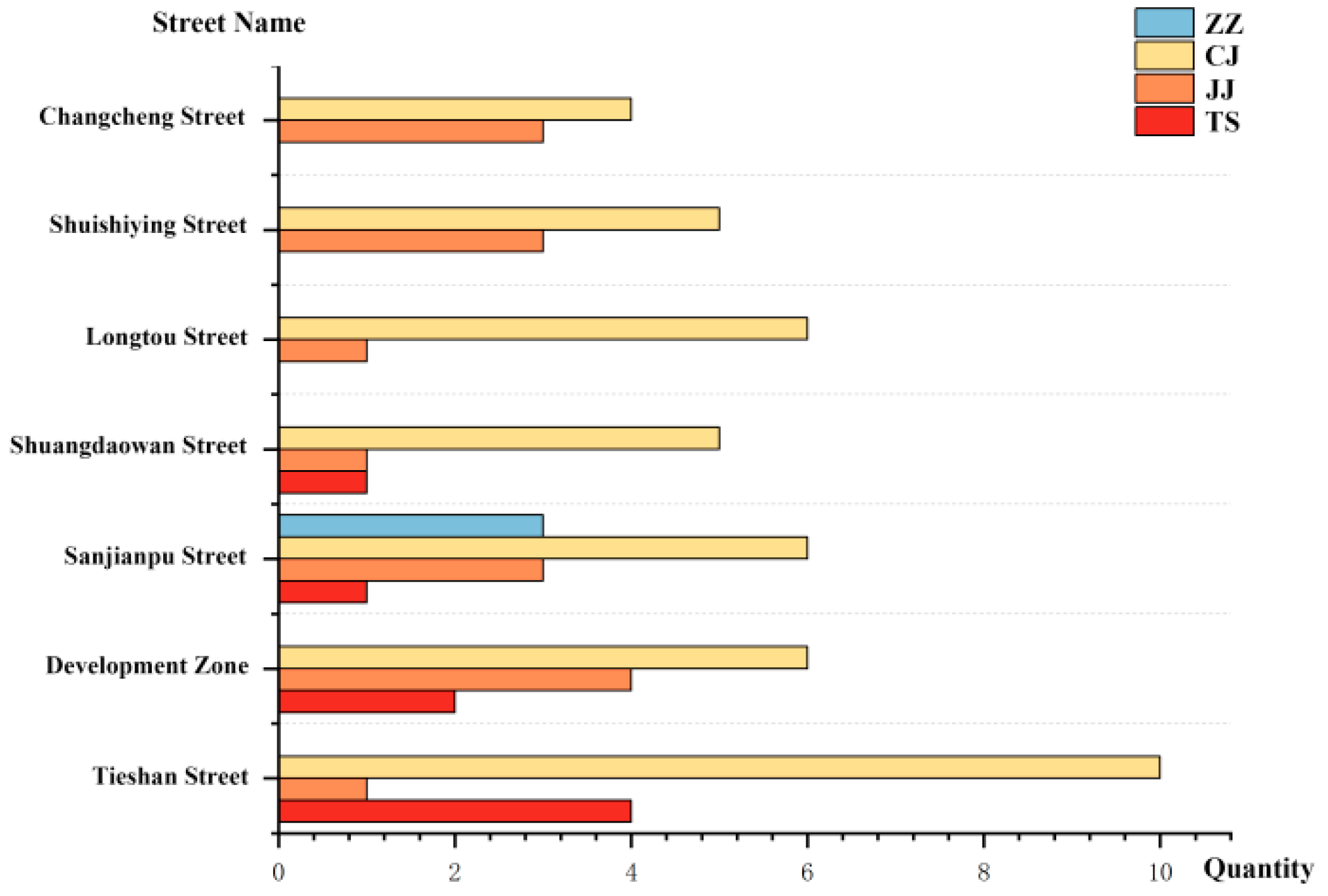
3.1. Results of Rural Type Analysis

Lvshunkou District has jurisdiction over seven streets and a total of 69 administrative villages, of which 8 are characteristic protection villages, 16 are cluster construction villages, 42 are suburban integration villages, and 3 are renovation and upgrading villages. From the perspective of quantitative relationships, quantitative analysis, as depicted in Figure 1, indicated a hierarchy of focus areas where rural integration takes precedence, followed by the cluster construction, characteristic protection, and, finally, renovation and upgrading of villages. Under the influence of the downtown area of Dalian City, the overall construction situation of villages in Lvshunkou District is relatively good, with about 51% of villages located within the urban development boundary.
From the perspective of location relationships (Figure 2), suburban integration villages and cluster construction villages are mostly distributed in suburban areas, being located in areas with relatively flat slopes and with more leading enterprises as well as being close to coastal highways, the Shenhai Expressway, and other areas with convenient external transportation.
The difference is that the distribution of suburban integration villages is more concentrated and dense, while that of cluster construction villages is more dispersed and balanced. The distribution of characteristic protection villages is uneven. Some of them have a high level of urbanization, and the cultivated land area is less; in addition, some of them are located on the edge of urban areas and have intact historical sites with high historical and cultural protection value. Under the influence of large-scale projects, renovation and upgrading villages are distributed in the coastal area of Chungkou Bay.

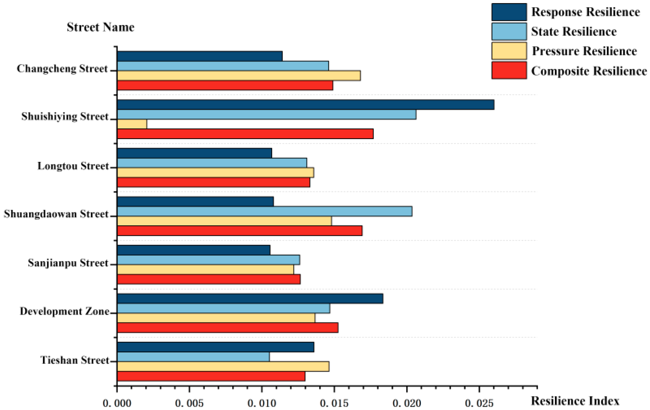
3.2. Differentiation and Clustering of Rural Resilience

The comprehensive resilience level of rural areas in Lvshunkou District shows the spatial layout characteristics of “high center and two low wings” (Figure 3), which gradually transitions from the high value in the center to the low value in the periphery, and the resilience value of coastal villages is generally low. High-resilience villages are mostly distributed on Shuishiying Street and Shuangdao Bay Street, while low-resilience villages are mostly distributed on Tieshan Street, Great Wall Street, and Sanjianbao Street. Shuishiying Street and Shuangdaowan Street have higher average comprehensive resilience levels, and the village resilience level there is more balanced. Sanjianbao Street and Longtou Street have low average comprehensive resilience levels. The Lvshunkou Economic and Technological Development Zone has a substantial difference in the resilience level [45].
Using the software Origin (Version 2021), statistical analysis was conducted to identify the differentiation and clustering characteristics of the resilience values across various rural villages. Specifically, the average comprehensive resilience of villages in Lvshunkou District is 0.0145, which is medium, and the maximum value is 0.0228, with a small spatial difference between the two. The lowest composite resilience is 0.0073, which is 4.7 times different from the highest value, and the individual difference is significant. According to the statistics of the number of villages with five resilience levels, we found that the average index of the high-comprehensive-resilience villages is 6.7 times that of the low-comprehensive-resilience villages, with a significant difference between the two types. The proportion of villages with a medium resilience level is the largest, at 46.4%, while the number of villages with high and low resilience levels is relatively small, at 8.7% and 5.8%, respectively. Rural resilience presented an inverted U-shaped distribution [46] (Figure 4).
From the perspective of village types, mostly cluster construction and suburban integration villages have high resilience levels, with a large between-group difference in the resilience level of characteristic protection villages and a small between-group difference in the resilience level of renovation and upgrading villages. There are no high-resilience characteristic protection villages or renovation and upgrading villages, and 50% of them have medium or a low resilience levels. In addition, 33% of the suburban integration villages are at a medium or a high resilience level, while 75% of the cluster construction villages are in the high-resilience zone. In summary, we can see that there is a high correlation between village type and resilience strength (Figure 5).

3.3. Differentiation and Clustering of the Rural Resilience Subsystem

The comprehensive resilience levels of characteristic protection villages vary greatly among groups. For example, Chenjia Village has the lowest comprehensive resilience index, but the state resilience index is the highest. First, it is necessary to strengthen daily monitoring and early warning of floods and strong winds, provide rural emergency products and services, and effectively enhance the anti-interference ability in the face of floods and other risks in order to prevent adverse effects on tourists and the value of local tourism [47].
A large proportion of cluster construction villages are regional central villages, and their resilience indexes are higher than those of the other three types of villages. Their service facilities and industrial models play a radiating and driving role, which is an important foundation for the economic transformation and upgrading of the respective districts and counties and an important platform for implementing innovation-driven development strategies.
Compared with other village types, suburban integration villages have medium-to-high response resilience. Consequently, these villages can preferentially undertake urban spillovers and have good background resource advantages, but high similarity [48]. In terms of response resilience, the governance ability and disaster prevention publicity of such villages need to be strengthened. For example, Zhangjiacun in Shuangdaowan Street, close to the Shenhai Expressway, has the advantages of taking the lead in realizing urbanization transformation and being a key area to improve the rural urbanization level. However, there are many enterprises and factories in Zhangjiacun, and in addition to serving the village population, there are more migrants from surrounding villages and towns, and the difficulty of coordinating the management of rural society has significantly increased [49].
The construction of major projects and other factors has restricted the development of renovation and upgrading villages, and their comprehensive resilience and subsystem resilience values are both low, with villagers facing the problems of uncertain future development and a lack of compensation. The renovation and relocation of these villages should be closely connected with village planning. Based on the principle of “optimizing structure, orderly guidance, and active governance”, the land use structure should be gradually optimized, abandoned land should be remediated, and the stock of residential land should be revitalized so as to realize the transition from passive guidance to active governance [50,51].
In conclusion, cluster construction villages in the stress and state resilience subsystem have substantial differences, as do suburban integration villages in the state resilience subsystem.

4. Discussion

To realize the systematic improvement of rural resilience, attention should be paid to stimulating the characteristic values and multiple functions of rural lifestyles, ecological resources, and landscape styles that are different from urban ones. Due to the different development among regions, all types of villages should cultivate rural resilience according to local conditions [52]. Based on the four aspects of rural space, industry, ecology, and governance (Figure 6), this paper formulated differentiated strategies for improving rural resilience depending on the shortcomings and advantages of different types of villages [53].

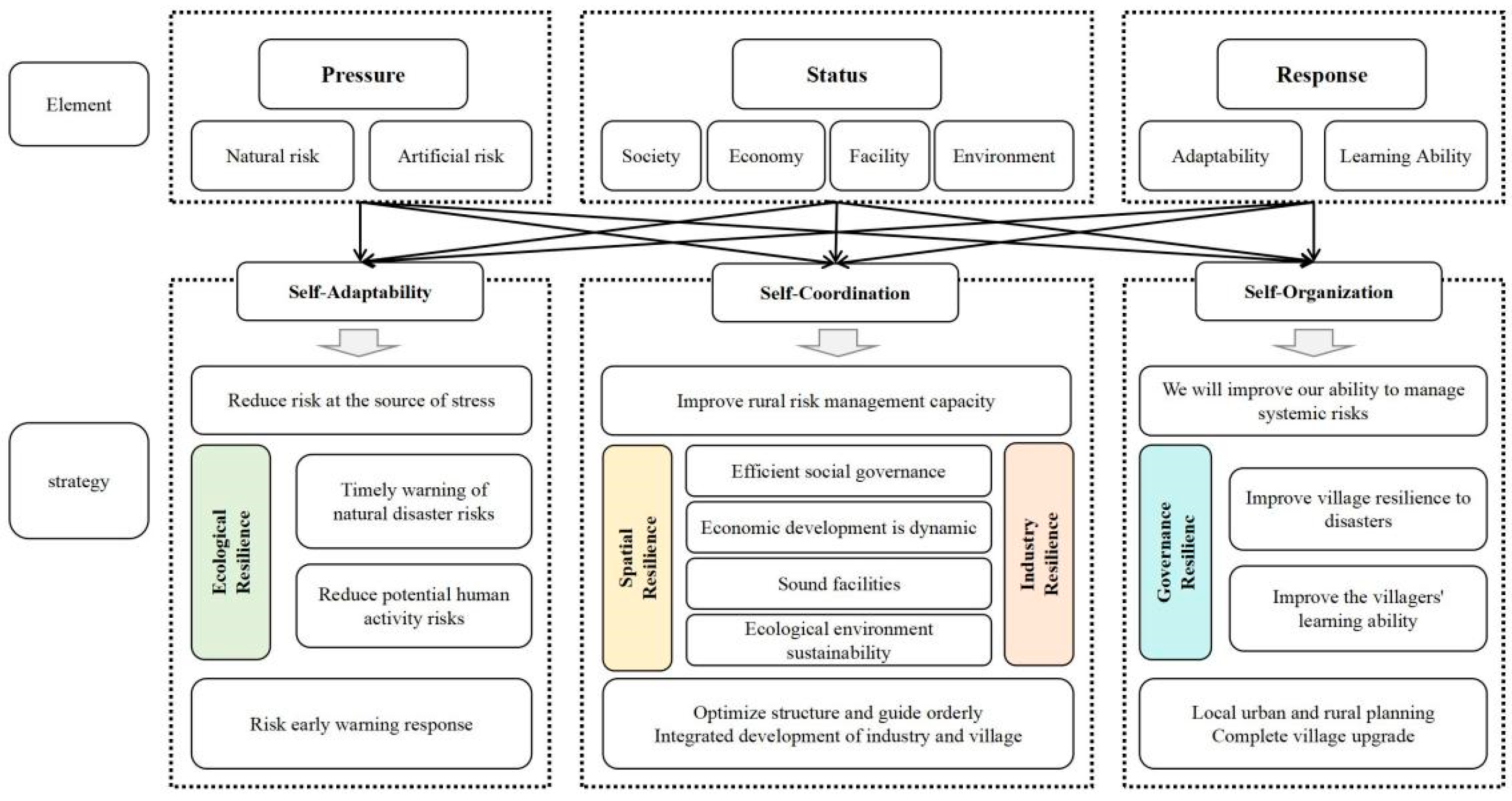
4.1. Classified and Sound Rural Spatial Resilience

The first three types of villages with good state resilience all have different degrees of residential and agricultural development risks, so it is necessary to carry out regular investigation of hidden security risks in residential areas and timely rectification of problem houses [54]. Special actions must be taken to improve cultivated land, residential land, and environmental land [55] and to ensure that the size of residential areas is kept at an appropriate level (Figure 7).
Characteristic protection villages should focus on strengthening the management and protection of rural roads to form a smooth urban–rural public transport network. Measures such as reasonable widening, realignment, and consolidation of existing rural roads should be taken to eliminate dead ends and T-junctions, thereby facilitating an intensive and smooth urban–rural road network pattern. The existing tourist service center and evacuation site construction should be improved to facilitate the collection and distribution of tourist groups [56]. Suburban integration villages can take actions to balance cultivated land occupation and compensation and the increase or decrease in urban and rural construction land, in addition to upgrading inefficient garden land and improving farmland quality [57]. Cluster construction and renovation and upgrading villages are the core of district streets. Combined with the regional pattern to improve rural public service facilities and infrastructure, at the level of rural infrastructure, it is necessary to promote the extension of urban infrastructure and public services to rural areas, establish good cooperation with enterprises to encourage investment from them, and establish cloud schools and cloud classrooms so that children in rural areas can enjoy high-quality urban education resources simultaneously. In addition, by expanding the capacity of central health hospitals on various streets and in different districts, villagers can enjoy convenient and high-quality medical and health services nearby. Furthermore, it is necessary to improve the information management level of village clinics and town health centers, establish health information databases for villagers, and form a medical treatment pattern of “minor diseases do not leave the village, and major diseases do not leave the district” to cope with longer-term structural questions caused by aging [58].

4.2. Classified and Sound Rural Industrial Resilience

Some characteristic protection villages with high comprehensive resilience indexes should pay attention to guiding and improving the standardization and standardized supervision of the rural tourism industry, including regularly checking the status level and responsibility of facilities and services [59] and ensuring service standardization and operation safety [60]. They should also pay attention to innovation and optimization of the characteristic and differentiated manufacturing of tourism products to avoid falling into the “strange circle” of homogenized competition. For example, Kamakura, a coastal city in Japan, attracts tourists to have an in-depth experience [61] by opening seaside baths, innovating ways of using its cultural heritage, and building original and unique shops [62], and the tourist satisfaction rate is as high as 85%. Characteristic protection villages in Lvshunkou District should ensure high-quality construction of rural tourism and strengthen diversified formats and innovative marketing models prominently [63], including adapting to the needs of consumption upgrading, creating an in-depth experience according to local conditions, and deepening the interaction and communication between tourists and places [64,65].
Cluster construction and suburban integration villages should closely focus on industrial revitalization and income benefits to enhance the rural economy resilience. First, they should give full play to the scale effect of land, industry, and population resources, relying on the golden sign of “Lvshunkou Big Cherry”; build a development model of “leading enterprises + cooperatives + modern farms and 10 family farms”; promote the integrated development of primary, secondary, and tertiary industries; and connect modern agricultural production and small-farmer production [66]. Second, they should actively cultivate online and offline sales networks to realize the production and processing of agricultural products [67], product circulation, direct supply, and direct sales. Third, they should explore how to use fresh e-commerce, online publicity, and drainage of agricultural products by means of “retail + catering” and “catch the sea + picking” and the offline development mode of “leisure and sightseeing–farming experience–agricultural science popularization–technology promotion” [42].

4.3. Classified and Sound Rural Ecological Resilience

To strengthen ecological resilience and enhance landscape attractiveness, we must first pay attention to improving the quality of the waterfront landscape, regulating and cleaning up the coastal coastline, and enhancing landmarks such as watchtowers and lighthouses [68]. Cluster construction and suburban integration villages should focus on the green development of the countryside; improve the level of ecological livability in the countryside; integrate the unique spiritual and cultural elements of Lvshunkou District into the village appearance; and jointly form a localized, distinctive, and diversified rural cultural network. Ecological restoration will be strengthened in villages that are regulated and upgraded [69], and blue bays and natural shorelines will be restored. Land with large slopes that are unsuitable for cultivation can be converted into terraces to prevent soil erosion [70,71].

4.4. Categorization and Improvement of Rural Governance Resilience

The response resilience of suburban integrated and agglomeration-enhanced villages is better than that of others, and the systems for daily monitoring, early warning, and prevention of disasters in these rural areas can be strengthened through the overall use of new technologies and traditional means so as to cope with one-off shocks or natural disasters caused by sudden shocks [72]. These villages should establish and improve the rural governance pattern with the participation of multiple subjects, promote the construction of a comprehensive emergency management system and team for multiple types of disasters and the entire process, establish an emergency material support mechanism, and build disaster relief material reserves in rural areas [73]. In addition, by engaging local rural communities in the planning and execution of public service improvements, they should make rural residents accurately interpret the early warning information, take the initiative to implement evacuation measures in time, continue to provide training services for early warning of disasters to improve the ability of rural residents to actively prepare for disasters, and explore diversified financial support channels to fully guarantee the effectiveness of disaster prevention and management in rural areas [74,75].
For rural areas that need to be renovated and upgraded, monitoring and evaluation mechanisms should be established to assess the impact of policy changes over time. If there is a plan to relocate a village in the short term, the government should lead in investing, fully respecting the will of the farmers [76] and considering the villagers’ overall employment and survival. Depending on the unique circumstances of each village, relocation may be either comprehensive or phased, partial relocation [77]. In addition, effective measures should be taken to protect the legitimate rights and interests of the relocated villagers and village collectives. For villages without relocation plans in the short term, the rectification of agricultural houses with security risks should be strengthened, dilapidated houses rebuilt, infrastructure increased, comprehensive service sites improved, and the overall health of village human settlements enhanced [78].

5. Conclusions

By constructing a rural classification index system, this paper classified and distinguished the rural areas in Lvshunkou District and identified the spatial distribution characteristics and development direction of suburban integration, cluster construction, characteristic protection, and renovation and upgrading of rural areas. Based on the resilience perspective, a rural system resilience assessment method was constructed; the weak links and governance needs of rural resilience were quantitatively identified; and rural system resilience reconstruction and improvement strategies were proposed based on the four aspects of rural space, industry, ecology, and governance. These differentiation strategies will help improve the coordination, adaptability, and self-organization of the rural system. In conclusion, the rural area of Lvshunkou District, intricately linked to the urban core of Dalian City, demonstrates a resilience pattern marked by significant inter-group disparities and robust spatial clustering. This pattern indicates a need to focus on revitalizing rural life functions, thereby enhancing the spatial appeal of this region. Economically, we advocate for the strategic guidance of resilient rural areas toward the intensive development of distinctive industries. This approach will capitalize on their inherent strengths and foster economic diversification and prosperity. Ecologically, we emphasize the promotion of green development practices in rural areas to safeguard the environment and support sustainable growth. Governance-wise, we propose strengthening the foundational aspects of rural life support and enhancing the efficiency of rural governance to ensure the well-being of the residents and the effective management of community resources. By addressing these key areas (economic development, ecological sustainability, and governance efficiency), we aim to cultivate a more cohesive and resilient rural landscape that is well integrated with the urban expanse of Dalian City. The results of this paper are conducive to promoting urban–rural integration and providing theoretical guidance and practical reference for realizing long-term rural governance.
However, due to limited data and conservative clustering method selection, there were some deviations and uncertainties. At present, the popular algorithms related to spatial clustering include social network analysis, the DBSCAN clustering algorithm, and the SOM-Kmeans algorithm, which can more objectively determine the number and category of classification. This is a development direction worth studying in the future.

Author Contributions

Conceptualization, Y.W. and G.L.; methodology, supervision, project administration, and funding acquisition, Y.W.; software, formal analysis, investigation, resources, data curation, writing—original draft preparation, writing—review and editing, and visualization, J.W.; validation, J.W., Y.W., and G.L. All authors have read and agreed to the published version of the manuscript.

Funding

This research was funded by the Youth Fund for Humanities and Social Sciences Research of the Ministry of Education (grant number 20YJCZH171).

Institutional Review Board Statement

Not applicable.

Informed Consent Statement

Not applicable.

Data Availability Statement

The data presented in this study are available upon request from the corresponding author.

Acknowledgments

We appreciate the developers of the relevant technologies and datasets, as well as the editors and reviewers for helpful comments.

Conflicts of Interest

The authors declare no conflicts of interest.

References

  1. Berchoux, T.; Watmough, G.R.; Hutton, C.W.; Atkinson, P.M. Agricultural shocks and drivers of livelihood precariousness across Indian rural communities. Landsc. Urban Plan. 2019, 189, 307–319. [Google Scholar] [CrossRef]
  2. Peng, L.; Tan, J.; Deng, W.; Liu, Y. Understanding the Resilience of Different Farming Strategies in Coping with Geo-Hazards: A Case Study in Chongqing, China. Int. J. Environ. Res. Public Health 2020, 17, 1226. [Google Scholar] [CrossRef] [PubMed]
  3. Marshall, A.; Wilson, C.A.; Dale, A. Telecommunications and natural disasters in rural Australia: The role of digital capability in building disaster resilience. J. Rural. Stud. 2023, 100, 102996. [Google Scholar] [CrossRef]
  4. Ashkenazy, A.; Calvão Chebach, T.; Knickel, K.; Peter, S.; Horowitz, B.; Offenbach, R. Operationalising resilience in farms and rural regions—Findings from fourteen case studies. J. Rural. Stud. 2018, 59, 211–221. [Google Scholar] [CrossRef]
  5. Gajić, A.; Krunić, N.; Protić, B. Classification of Rural Areas in Serbia: Framework and Implications for Spatial Planning. Sustainability 2021, 13, 1596. [Google Scholar] [CrossRef]
  6. Ruiz, L.D. Refinement of the OECD Regional Typology: Economic Performance of Remote Rural Regions; European Regional Science Association: Paris, France, 2010. [Google Scholar]
  7. Schwarz, A.; Béné, C.; Bennett, G.; Boso, D.; Hilly, Z.; Paul, C.; Posala, R.; Sibiti, S.; Andrew, N. Vulnerability and resilience of remote rural communities to shocks and global changes: Empirical analysis from Solomon Islands. Glob. Environ. Chang. 2011, 21, 1128–1140. [Google Scholar] [CrossRef]
  8. Aksha, S.K.; Emrich, C.T. Benchmarking Community Disaster Resilience in Nepal. Int. J. Env. Res. Public Health 2020, 17, 1985. [Google Scholar] [CrossRef] [PubMed]
  9. Fang, Y.; Zhu, F.; Qiu, X.; Zhao, S. Effects of natural disasters on livelihood resilience of rural residents in Sichuan. Habitat Int. 2018, 76, 19–28. [Google Scholar] [CrossRef]
  10. Chen, X.; Rong, F.; Li, S. Driving Force–Pressure–State–Impact–Response-Based Evaluation of Rural Human Settlements’ Resilience and Their Influencing Factors: Evidence from Guangdong, China. Sustainability 2024, 16, 813. [Google Scholar] [CrossRef]
  11. McIntyre, S.; Roy, G. Revisiting the dimensions of rural resilience: The COVID-19 pandemic. J. Rural. Stud. 2023, 103, 103107. [Google Scholar] [CrossRef]
  12. Mayar, K.; Carmichael, D.G.; Shen, X. Stability and Resilience—A Systematic Approach. Buildings 2022, 12, 1242. [Google Scholar] [CrossRef]
  13. Cui, Z.Z.; Li, E.R.; Li, Y.H.; Deng, Q.Q.; Shahtahmassebi, A. The impact of poverty alleviation policies on rural economic resilience in impoverished areas: A case study of Lankao County, China. J. Rural. Stud. 2023, 99, 92–106. [Google Scholar] [CrossRef]
  14. Wang, D.; Shi, Y.; Wan, K. Integrated evaluation of the carrying capacities of mineral resource-based cities considering synergy between subsystems. Ecol. Indic. 2020, 108, 105701. [Google Scholar] [CrossRef]
  15. Zhang, L.; Peng, W.; Zhang, J. Assessment of Land Ecological Security from 2000 to 2020 in the Chengdu Plain Region of China. Land 2023, 12, 1448. [Google Scholar] [CrossRef]
  16. Fu, X.F.; Liu, Y.; Xie, Z.Q.; Jiang, F.S.; Xu, J.R.; Yang, Z.B.; Deng, Z.T.; Wang, Q.S.; Liao, M.F.; Wu, X.D.; et al. A coupled PSR-based framework for holistic modeling and flood resilience assessment: A case study of the 2022 flood events in five southern provinces of China. J. Hydrol. 2024, 636, 131255. [Google Scholar] [CrossRef]
  17. Zhao, H.; Guo, X.; Peng, N. What catalyzes the proactive recovery of peasants from the COVID-19 pandemic? A livelihood perspective in Ningqiang County, China. Int. J. Disaster Risk Reduct. 2022, 73, 102920. [Google Scholar] [CrossRef] [PubMed]
  18. Xie, X.; Zhou, G.; Yu, S. Study on Rural Ecological Resilience Measurement and Optimization Strategy Based on PSR-“Taking Weiyuan in Gansu Province as an Example”. Sustainability 2023, 15, 5462. [Google Scholar] [CrossRef]
  19. Wang, D.; Li, Y.; Yang, X.; Zhang, Z.; Gao, S.; Zhou, Q.; Zhuo, Y.; Wen, X.; Guo, Z. Evaluating urban ecological civilization and its obstacle factors based on integrated model of PSR-EVW-TOPSIS: A case study of 13 cities in Jiangsu Province, China. Ecol. Indic. 2021, 133, 108431. [Google Scholar] [CrossRef]
  20. Zhang, Y.; Shang, K.J. Cloud model assessment of urban flood resilience based on PSR model and game theory. Int. J. Disaster Risk Reduct. 2023, 97, 104050. [Google Scholar] [CrossRef]
  21. Ji, C.; Yang, H.; Pei, X.; Zhang, X.; Chen, L.; Liang, D.; Cao, Y.; Pan, J.; Chen, M. Dynamic Integrated Ecological Assessment along the Corridor of the Sichuan–Tibet Railway. Land 2024, 13, 857. [Google Scholar] [CrossRef]
  22. Sun, B.D.; Tang, J.C.; Yu, D.H.; Song, Z.W.; Wang, P.G. Ecosystem health assessment: A PSR analysis combining AHP and FCE methods for Jiaozhou Bay, China. Ocean Coast. Manag. 2019, 168, 41–50. [Google Scholar] [CrossRef]
  23. National Rural Revitalization Strategic Plan (2018–2022). Available online: https://www.gov.cn/zhengce/2018-09/26/content_5325534.htm?eqid=a7d9fff500028f4c00000003646a3478 (accessed on 8 April 2024).
  24. Bański, J.; Mazur, M. Classification of rural areas in Poland as an instrument of territorial policy. Land Use Policy 2016, 54, 1–17. [Google Scholar] [CrossRef]
  25. Prus, B.; Bacior, S.; Dudzinska, M. Identification of spatial-settling status of rural areas of southern poland a case study. In Proceedings of the 17TH International Scientific Conference: Engineering for Rural Development, Jelgava, Latvia 23–25 May 2018; Malinovska, L., Osadcuks, V., Eds.; Latvia University of Life Sciences and Technologies: Jerlgava, Latvia, 2018; pp. 439–444. [Google Scholar]
  26. Cattivelli, V. Delimiting Rural Areas: Evidence from the Application of Different Methods Elaborated by Italian Scholars. Land 2022, 11, 1674. [Google Scholar] [CrossRef]
  27. Dijkstra, L.; Ruiz, V.; Brezzi, M. OECD Extended Regional Typology: The Economic Performance of Remote Rural Regions; OECD Publishing: Paris, France, 2011. [Google Scholar]
  28. Castrorao Barba, A.; Aleo Nero, C.; Battaglia, G.; Zambito, L.; Virga, L.; Messina, A.; Cangemi, M.; Bazan, G. Continuity, Resilience, and Change in Rural Settlement Patterns from the Roman to Islamic Period in the Sicani Mountains. Land 2024, 13, 400. [Google Scholar] [CrossRef]
  29. Wen, Y.; Zhang, Z.; Liang, D.; Xu, Z. Rural Residential Land Transition in the Beijing-Tianjin-Hebei Region: Spatial-Temporal Patterns and Policy Implications. Land. Use Policy 2020, 96, 104700. [Google Scholar] [CrossRef]
  30. Tang, W.; Li, J.; Lei, Z.; Wang, E.; Shen, W. Creating social–physical resilience to natural disasters: Lessons from the Wenchuan earthquake. Nat. Hazards 2015, 79, 1111–1132. [Google Scholar] [CrossRef]
  31. Hill, M. Rural Settlement and the Urban Impact on the Countryside; Hodder & Stoughton: London, UK, 2003; pp. 58–72. [Google Scholar]
  32. Wolfslehner, B.; Vacik, H. Evaluating sustainable forest management strategies with the Analytic Network Process in a Pressure-State-Response framework. J. Environ. Manag. 2008, 88, 1–10. [Google Scholar] [CrossRef]
  33. Rapport, D.J.; Friend, A.M. Towards a Comprehensive Framework for Environmental Statistics: A Stress-Response Approach; Statistics Canada: Ottawa, ON, Canada, 1979.
  34. Hazbavi, Z.; Sadeghi, S.H.; Gholamalifard, M.; Davudirad, A.A. Watershed health assessment using the pressure–state–response (PSR) framework. Land. Degrad. Dev. 2020, 31, 3–19. [Google Scholar] [CrossRef]
  35. Cutter, S.L.; Barnes, L.; Berry, M.; Burton, C.; Evans, E.; Tate, E.; Webb, J. A place-based model for understanding community resilience to natural disasters. Glob. Environ. Chang. 2008, 18, 598–606. [Google Scholar] [CrossRef]
  36. Bestelmeyer, B.T.; Tugel, A.J.; Peacock, G.L.; Robinett, D.G.; Shaver, P.L.; Brown, J.R.; Herrick, J.E.; Sanchez, H.; Havstad, K.M. State-and-Transition Models for Heterogeneous Landscapes: A Strategy for Development and Application. Rangel. Ecol. Manag. 2009, 62, 1–15. [Google Scholar] [CrossRef]
  37. Guidelines for Village Planning in Liaoning Province. Available online: https://zrzy.ln.gov.cn/zrzy/zfxxgk/fdzdgknr/lzyj/zrzytgfxwj/zhgl/070E3695822F4C889D4F1712899A0F86/P020210928576426549628.pdf (accessed on 8 April 2024).
  38. Davies, A.; Lockstone-Binney, L.; Holmes, K. Recognising the value of volunteers in performing and supporting leadership in rural communities. J. Rural. Stud. 2021, 86, 136–144. [Google Scholar] [CrossRef]
  39. Norris, F.H.; Stevens, S.P.; Pfefferbaum, B.; Wyche, K.F.; Pfefferbaum, R.L. Community Resilience as a Metaphor, Theory, Set of Capacities, and Strategy for Disaster Readiness. Am. J. Community Psychol. 2008, 41, 127–150. [Google Scholar] [CrossRef] [PubMed]
  40. Chen, S.; Bai, Y.; Li, H.; Liu, W. Impact of farmers’ livelihood behavior on soil erosion in hilly areas—A comparison between erosion controlled and uncontrolled areas of southern China. Arab. J. Geosci. 2021, 14, 1–11. [Google Scholar] [CrossRef]
  41. Guo, X.; Kapucu, N. Examining the impacts of disaster resettlement from a livelihood perspective: A case study of Qinling Mountains, China. Disasters 2018, 42, 251–274. [Google Scholar] [CrossRef] [PubMed]
  42. Chen, M.; Jiang, Y.; Wang, E.; Wang, Y.; Zhang, J. Measuring Urban Infrastructure Resilience via Pressure-State-Response Framework in Four Chinese Municipalities. Appl. Sci. 2022, 12, 2819. [Google Scholar] [CrossRef]
  43. Liu, J.; Cao, X.; Zhao, L.; Dong, G.; Jia, K. Spatiotemporal Differentiation of Land Ecological Security and Its Influencing Factors: A Case Study in Jinan, Shandong Province, China. Front. Environ. Sci. 2022, 10, 824254. [Google Scholar] [CrossRef]
  44. Peacock, C.S. Response to Dantas-Torres and Marcondes: Economics and benefits of genome research for neglected tropical diseases. Trends Parasitol. 2008, 24, 157–158. [Google Scholar] [CrossRef]
  45. Zhao, R.; Fang, C.; Liu, H.; Liu, X. Evaluating urban ecosystem resilience using the DPSIR framework and the ENA model: A case study of 35 cities in China. Sustain. Cities Soc. 2021, 72, 102997. [Google Scholar] [CrossRef]
  46. Yang, H.; Zhai, G.; Zhang, Y. Ecological vulnerability assessment and spatial pattern optimization of resource-based cities: A case study of Huaibei City, China. Hum. Ecol. Risk Assess. 2021, 27, 606–625. [Google Scholar] [CrossRef]
  47. Mayar, K.; Carmichael, D.G.; Shen, X. Resilience and Systems—A Review. Sustainability 2022, 14, 8327. [Google Scholar] [CrossRef]
  48. Siebeneck, L.; Arlikatti, S.; Andrew, S.A. Using provincial baseline indicators to model geographic variations of disaster resilience in Thailand. Nat. Hazards 2015, 79, 955–975. [Google Scholar] [CrossRef]
  49. Cutter, S.L.; Ash, K.D.; Emrich, C.T. Urban–Rural Differences in Disaster Resilience. Ann. Assoc. Am. Geogr. 2016, 106, 1236–1252. [Google Scholar] [CrossRef]
  50. Ji, Y.; Imai, H. Creative Revitalization in Rural Japan. Asian Stud. 2022, 10, 211–240. [Google Scholar] [CrossRef]
  51. Gerlitz, J.; Macchi, M.; Brooks, N.; Pandey, R.; Banerjee, S.; Jha, S.K. The Multidimensional Livelihood Vulnerability Index – an instrument to measure livelihood vulnerability to change in the Hindu Kush Himalayas. Clim. Dev. 2016, 9, 124–140. [Google Scholar] [CrossRef]
  52. Simoniello, T.; Coluzzi, R.; D’Emilio, M.; Imbrenda, V.; Salvati, L.; Sinisi, R.; Summa, V. Going Conservative or Conventional? Investigating Farm Management Strategies in between Economic and Environmental Sustainability in Southern Italy. Agronomy 2022, 12, 597. [Google Scholar] [CrossRef]
  53. Zeng, P.; Sun, F.; Liu, Y.; Wang, Y.; Li, G.; Che, Y. Mapping future droughts under global warming across China: A combined multi-timescale meteorological drought index and SOM-Kmeans approach. Weather. Clim. Extrem. 2021, 31, 100304. [Google Scholar] [CrossRef]
  54. Zhao, R.; Fang, C.; Liu, J.; Zhang, L. The evaluation and obstacle analysis of urban resilience from the multidimensional perspective in Chinese cities. Sustain. Cities Soc. 2022, 86, 104160. [Google Scholar] [CrossRef]
  55. Brentan, B.; Meirelles, G.; Luvizotto, E.; Izquierdo, J. Hybrid SOM+k-Means clustering to improve planning, operation and management in water distribution systems. Environ. Model. Softw. 2018, 106, 77–88. [Google Scholar] [CrossRef]
  56. Liu, L.; Ross, H.; Ariyawardana, A. Building rural resilience through agri-food value chains and community interactions: A vegetable case study in wuhan, China. J. Rural. Stud. 2023, 101, 103047. [Google Scholar] [CrossRef]
  57. Zhang, J.; Gan, J.; Wu, Y.; Liu, J.; Zhang, S.; Shao, B. Research on the Resilience Evaluation and Spatial Correlation of China’s Sports Regional Development Under the New Concept. Front. Psychol. 2022, 12, 763501. [Google Scholar] [CrossRef]
  58. Rescia, A.J.; Willaarts, B.A.; Schmitz, M.F.; Aguilera, P.A. Changes in land uses and management in two Nature Reserves in Spain: Evaluating the social–ecological resilience of cultural landscapes. Landsc. Urban Plan. 2010, 98, 26–35. [Google Scholar] [CrossRef]
  59. Ghahramani, L.; McArdle, K.; Fatorić, S. Minority Community Resilience and Cultural Heritage Preservation: A Case Study of the Gullah Geechee Community. Sustainability 2020, 12, 2266. [Google Scholar] [CrossRef]
  60. Sargani, G.R.; Jiang, Y.S.; Joyo, M.A.; Liu, Y.; Shen, Y.; Chandio, A.A. No farmer no food, assessing farmers climate change mitigation, and adaptation behaviors in farm production. J. Rural. Stud. 2023, 100, 103035. [Google Scholar] [CrossRef]
  61. Hu, X.; Li, L.; Dong, K. What matters for regional economic resilience amid COVID-19? Evidence from cities in Northeast China. Cities 2022, 120, 103440. [Google Scholar] [CrossRef] [PubMed]
  62. Bui, H.T.; Jones, T.E.; Weaver, D.B.; Le, A. The adaptive resilience of living cultural heritage in a tourism destination. J. Sustain. Tour. 2020, 28, 1022–1040. [Google Scholar] [CrossRef]
  63. Jiménez-Medina, P.; Artal-Tur, A.; Sánchez-Casado, N. Tourism Business, Place Identity, Sustainable Development, and Urban Resilience: A Focus on the Sociocultural Dimension. Int. Reg. Sci. Rev. 2021, 44, 170–199. [Google Scholar] [CrossRef]
  64. Nasiri, N.A.; Al-Awadhi, T.; Hereher, M.; Ahsan, R.; AlRubkhi, A.G. Changing Urban Ecology a Challenge for Coastal Urban Resilience: A Study on Muscat. Environ. Urban. ASIA 2020, 11, 10–28. [Google Scholar] [CrossRef]
  65. Newman, G.; Li, D.; Zhu, R.; Ren, D. Resilience through Regeneration: The economics of repurposing vacant land with green infrastructure. Landsc. Arch. Front. 2018, 6, 10. [Google Scholar] [CrossRef]
  66. Duo, L.; Li, Y.; Zhang, M.; Zhao, Y.; Wu, Z.; Zhao, D. Spatiotemporal Pattern Evolution of Urban Ecosystem Resilience Based on “Resistance-Adaptation-Vitality”: A Case Study of Nanchang City. Front. Earth Sci. 2022, 10, 902444. [Google Scholar] [CrossRef]
  67. Gafter, L.; Tchetchik, A.; Shilo, S. Urban resilience as a mitigating factor against economically driven out-migration during COVID-19: The case of Eilat, a tourism-based city. Cities 2022, 125, 103636. [Google Scholar] [CrossRef]
  68. Yang, J.; Ding, Y.; Zhang, L. Conceptualizing and Measuring Megacity Resilience with an Integrated Approach: The Case of China. Sustainability 2022, 14, 11685. [Google Scholar] [CrossRef]
  69. Fang, J.; Xiong, K.; Chi, Y.; Song, S.; He, C.; He, S. Research Advancement in Grassland Ecosystem Vulnerability and Ecological Resilience and Its Inspiration for Improving Grassland Ecosystem Services in the Karst Desertification Control. Plants 2022, 11, 1290. [Google Scholar] [CrossRef]
  70. Tang, H.; Zhong, Q.; Chen, C.; Martek, I. The Adaptive Seismic Resilience of Infrastructure Systems: A Bayesian Networks Analysis. Systems 2023, 11, 84. [Google Scholar] [CrossRef]
  71. Liu, H.; Pan, W.; Su, F.; Huang, J.; Luo, J.; Tong, L.; Fang, X.; Fu, J. Livelihood Resilience of Rural Residents under Natural Disasters in China. Sustainability 2022, 14, 8540. [Google Scholar] [CrossRef]
  72. Dilley, L.; Gkartzios, M.; Odagiri, T. Developing counterurbanisation: Making sense of rural mobility and governance in Japan. Habitat Int. 2022, 125, 102595. [Google Scholar] [CrossRef]
  73. Ge, D.; Zheng, Y.; Zhang, S.; Fu, J.; Su, F. Spatio-Temporal Pattern and Influence Mechanism of Rural Human Settlements System Resilience: Case from China. Sustainability 2022, 14, 14533. [Google Scholar] [CrossRef]
  74. Luo, X.; Zhang, C.; Song, J.; Qiu, Z.; Li, W.; Wang, W. Do Livelihood Strategies Affect the Livelihood Resilience of Farm Households in Flooded Areas? Evidence From Hubei Province, China. Front. Ecol. Evol. 2022, 10, 909172. [Google Scholar] [CrossRef]
  75. Tao, T.; Ma, L.; Wang, X.; Wu, S.; Shi, Z.; Cui, X. Resilience or efficiency? Strategic options for sustainable development of agricultural systems in ecologically fragile areas of China. Sci. Total. Environ. 2023, 881, 163411. [Google Scholar] [CrossRef]
  76. Jha, S.K.; Negi, A.K.; Alatalo, J.M.; Negi, R.S. Socio-ecological vulnerability and resilience of mountain communities residing in capital-constrained environments. Mitig. Adapt. Strateg. Glob. Chang. 2021, 26, 38. [Google Scholar] [CrossRef]
  77. Young, A.F.; Marengo, J.A.; Martins Coelho, J.O.; Scofield, G.B.; de Oliveira Silva, C.C.; Prieto, C.C. The role of nature-based solutions in disaster risk reduction: The decision maker’s perspectives on urban resilience in São Paulo state. Int. J. Disaster Risk Reduct. 2019, 39, 101219. [Google Scholar] [CrossRef]
  78. Deng, G.; Si, J.; Zhao, X.; Han, Q.; Chen, H. Evaluation of Community Disaster Resilience (CDR): Taking Luoyang Community as an Example. Math. Probl. Eng. 2022, 2022, 5177379. [Google Scholar] [CrossRef]
Figure 1. Different types of villages on different streets.
Sustainability 16 06708 g001
Figure 2. Rural classification.
Sustainability 16 06708 g002
Figure 3. (a) Stress resilience, (b) state resilience, (c) response resilience, and (d) composite resilience.
Sustainability 16 06708 g003
Figure 4. (a) Resilience index differentiation of different village subsystems and (b) differentiation of the comprehensive resilience index of different types of villages.
Sustainability 16 06708 g004
Figure 5. Schematic diagram of the differentiation of resilience index of each street.
Sustainability 16 06708 g005
Figure 6. Strategy framework of resilience pattern reconstruction of rural systems.
Sustainability 16 06708 g006
Figure 7. Strategies for improving the rural resilience of different types of villages.
Sustainability 16 06708 g007
Table 1. Characteristics of traditional planning and resilience planning methods.
Planning ContentTraditional PlanningResilience Planning
Disaster risk managementFocuses more on short- and medium-term contingency planningFocuses more on medium- and long-term strategic planning
Planning vision and strategyStatic programmingDynamic adaptive planning
Public participation and multi-agent coordinationLimited public participationEmphasizes the importance of collective action and self-organization
Understanding and application of local traditional knowledgeMore reliance on standardized building techniquesLearning and understanding the local architectural culture
Table 2. Rural data survey form.
Village Name
CategoryVariable
Population sizeTotal number of households
Migrant population
Number of people over 60 years old
Number of existing enterprises in the village
Industrial characteristicsVillage collective income
Main sources of income
Types of main cash crops
Whether there are rural tourism projects
Public service facilitiesNumber of commercial facilities
Number of hospitals/health centers
Number of squares/parks and green spaces
Name and number of historical buildings
Number of courier stations
Number of households covered by the internet
Garbage collection and the number of gathering points
Whether there are disaster evacuation routes and venues in the village
Table 3. Rural classification index.
ClassificationTSJJCJZZ
Bottom-line constraintWhether it intersects or is close to the ecological protection red line
Whether it intersects or is close to town development boundaries
Characteristic advantageWhether it has historical sites or scenic spots
Whether it is coastal
Whether there are fishing, tourism, or other industrial agglomeration areas
Whether it is a central village
Whether it is a major project to relocate the village
Dominant functionLeading function of the villageCultural travel, healthCulture and lifeEducation and industryConservation and ecology
√ Binding; ○ anticipation.
Table 4. Evaluation system of the rural resilience index.
SubsystemIndicatorIndicator DescriptionAttributes
Pressure
resilience
Natural disaster riskAverage gradeReflects the rural production risk
Mean elevationReflects the risk of rural living
Average annual precipitation × population sizeReflects the village rainstorm disaster risk
Human activity riskNumber of enterprisesReflects the impact of human activities on the village
Aging levelReflects the degree of aging
Rate of population lossReflects the degree of population loss in the village
State resilienceSocietyVillage scaleReflects the village size+
Population sizeReflect the village size+
Village residential land areaReflects the scale of village land+
Per capita homestead areaReflects the basic housing conditions of villagers+
EconomyProportion of cultivated landReflects the proportion of agriculture+
Per capita disposable income of villagersReflects the level of economic development+
FacilityRoad network densityReflects the degree of rural connectivity to the outside world+
Number of bus stopsReflects the level of rural relations with the outside world+
Number of commercial facilitiesReflects the diversity in villagers’ incomes+
Number of express stationsReflects the convenience of life+
Number of public toiletsReflects the level of rural infrastructure+
Number of primary and secondary schoolsReflects the level of rural basic education support+
Number of hospitals and clinicsReflects the level of medical security of rural residents+
EnvironmentFraction of vegetation coverage (FVC)Reflects the degree of village greening+
Water areaReflects the livable level of life+
Number of parks and squaresReflects the livable level of life+
Response resilienceAdaptabilityNumber of health insurance enrolleesReflects the self-organization of the village+
Emergency rescue personnelReflects the standard of living security+
Per capita effective refuge areaReflects the situation of the refuge+
Learning abilityDisaster prevention information dissemination degreeReflects disaster prevention information+
Number of internet usersReflects the level of rural communication facilities+
Disclaimer/Publisher’s Note: The statements, opinions and data contained in all publications are solely those of the individual author(s) and contributor(s) and not of MDPI and/or the editor(s). MDPI and/or the editor(s) disclaim responsibility for any injury to people or property resulting from any ideas, methods, instructions or products referred to in the content.

