
Sustainability of Gulf of Mexico Coastal Estuaries and Lagoons: Interactions with Hydrocarbon Production—A Review with a Look to the Future

 ,
,  ,
,
Abstract
:1. Introduction
2. An Overview of Gulf of Mexico (GOM) Coastal Ecosystems
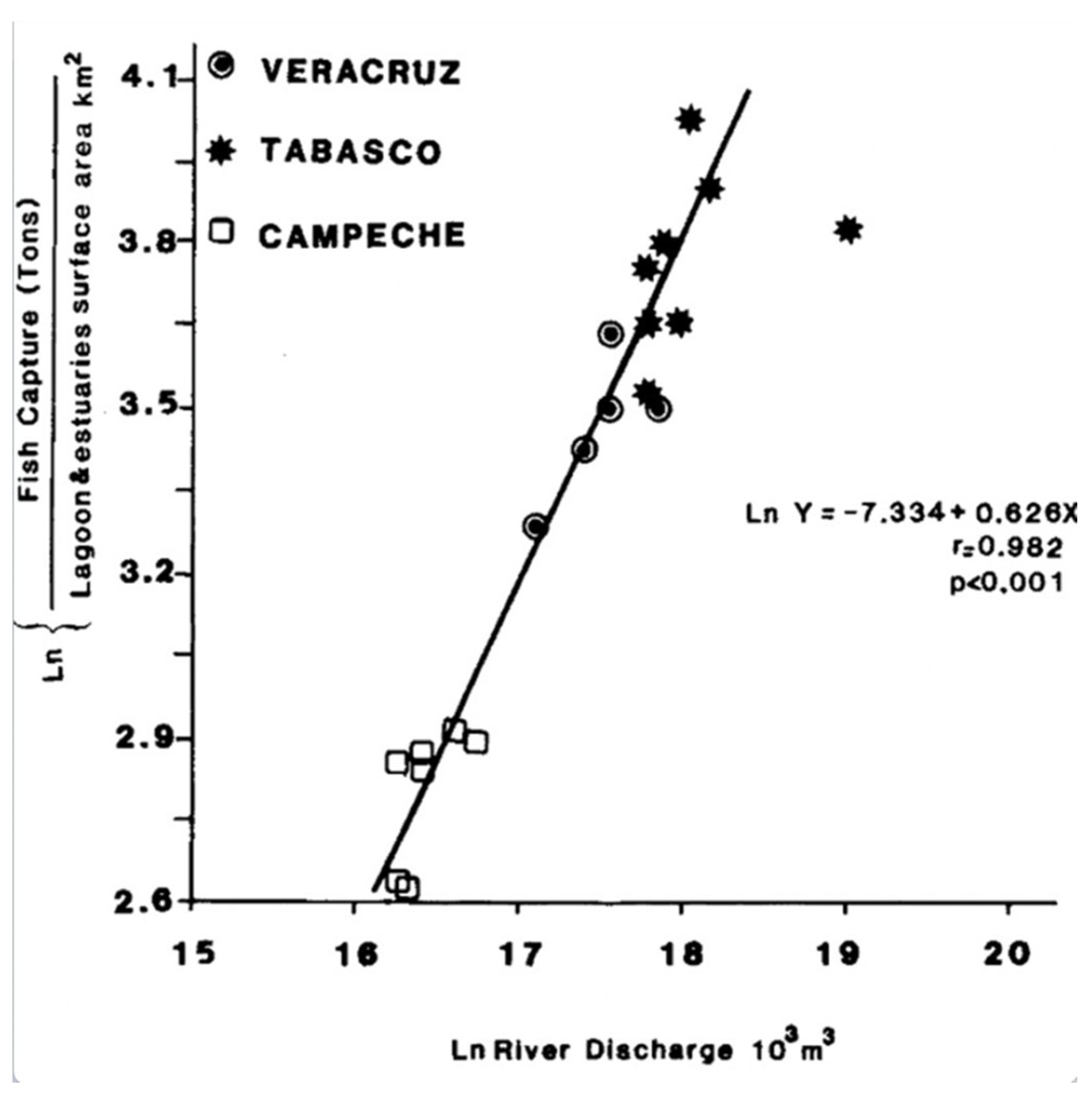
2.1. The Most Important Gulf of Mexico Estuaries and Coastal Lagoons
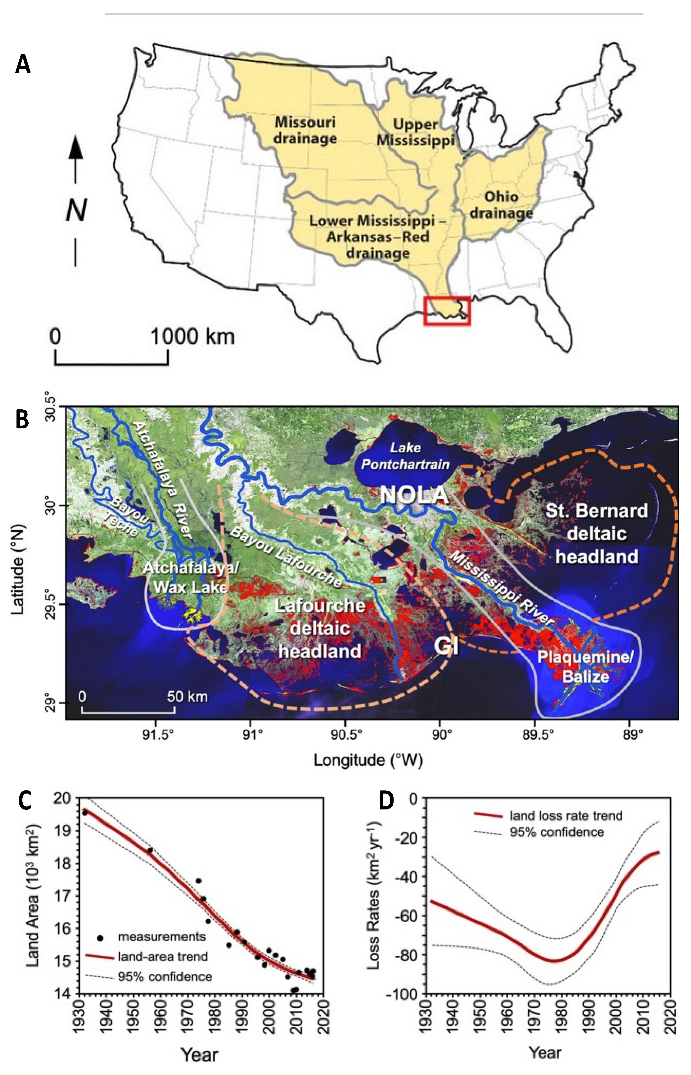
2.1.1. Mississippi River Delta
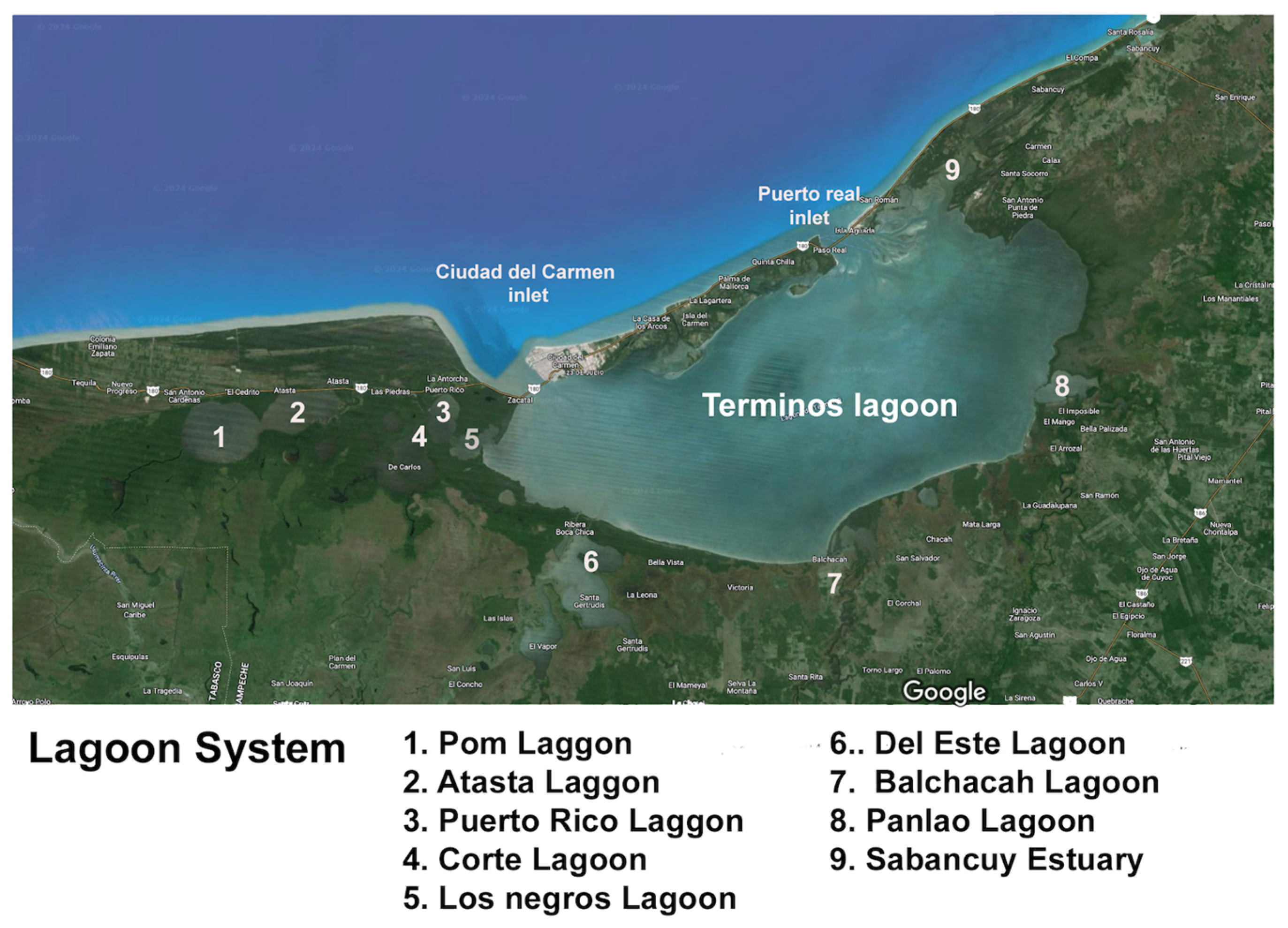
2.1.2. Terminos Lagoon
- (1)
- There is high natural net primary productivity and secondary productivity;
- (2)
- Ecological diversity of the lagoon ecosystem is high in terms of species diversity, population assemblages, biogeochemical and ecological processes, and important critical habitats;
- (3)
- There are important fisheries for oysters and other shellfish, crustaceans, and fin fish;
- (4)
- There are important interactions with Campeche Sound through the tidal inlets, and among primary productivity, nekton community ecology and habitats;
- (5)
- The unique seasonality of environmental dynamics and hydrological and biological processes;
- (6)
- There are important annual changes in environmental behavior of the ecosystem;
- (7)
- The impacts of petroleum-related activities and petrochemical industries;
- (8)
- The incorporation of Laguna de Terminos in the natural protected areas system of Mexico;
- (9)
- The complex interactions among ecological and economic systems with governmental regulations and constraints;
- (10)
- The lack of inclusion of the idea of system functioning as a conceptual framework for sustainable management of the deltaic-lagoon systems [35].
2.2. Socio-Environmental Characteristics of the Coastal Zone of the Gulf of Mexico
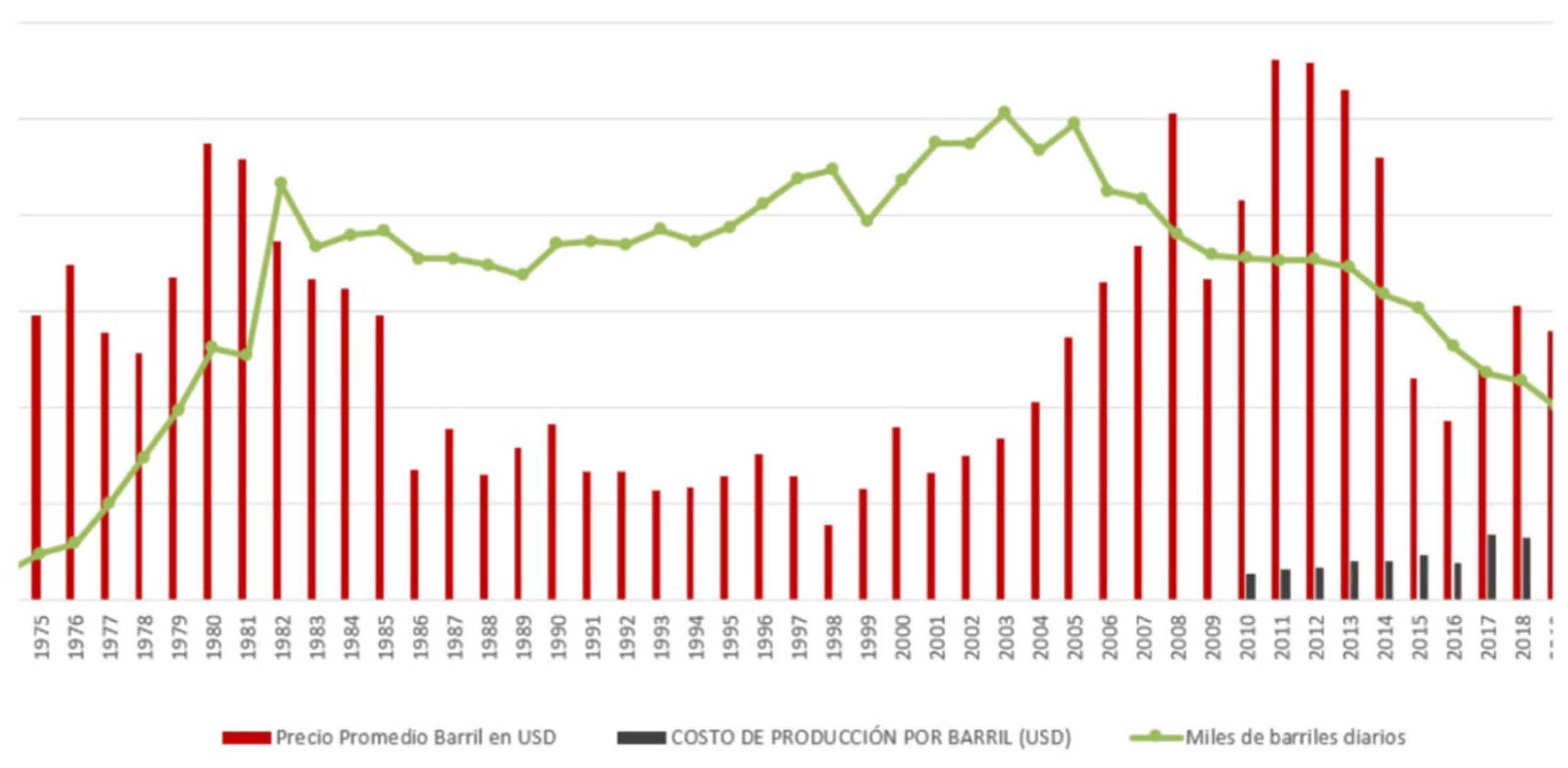
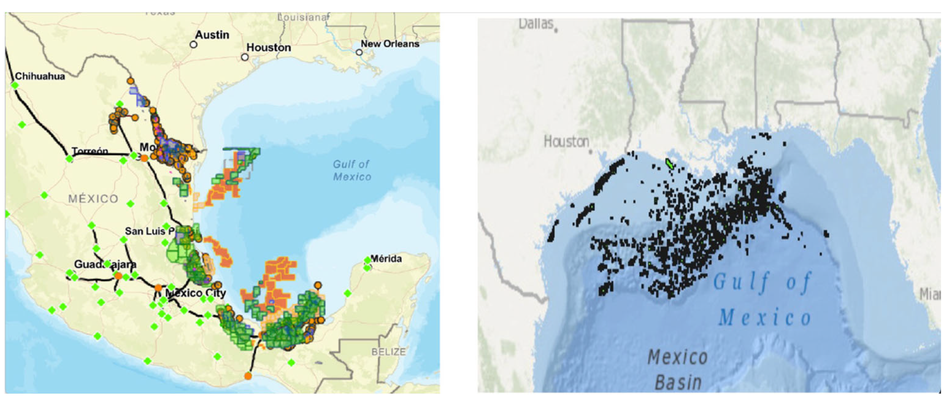
3. Oil Sector in the Gulf of Mexico
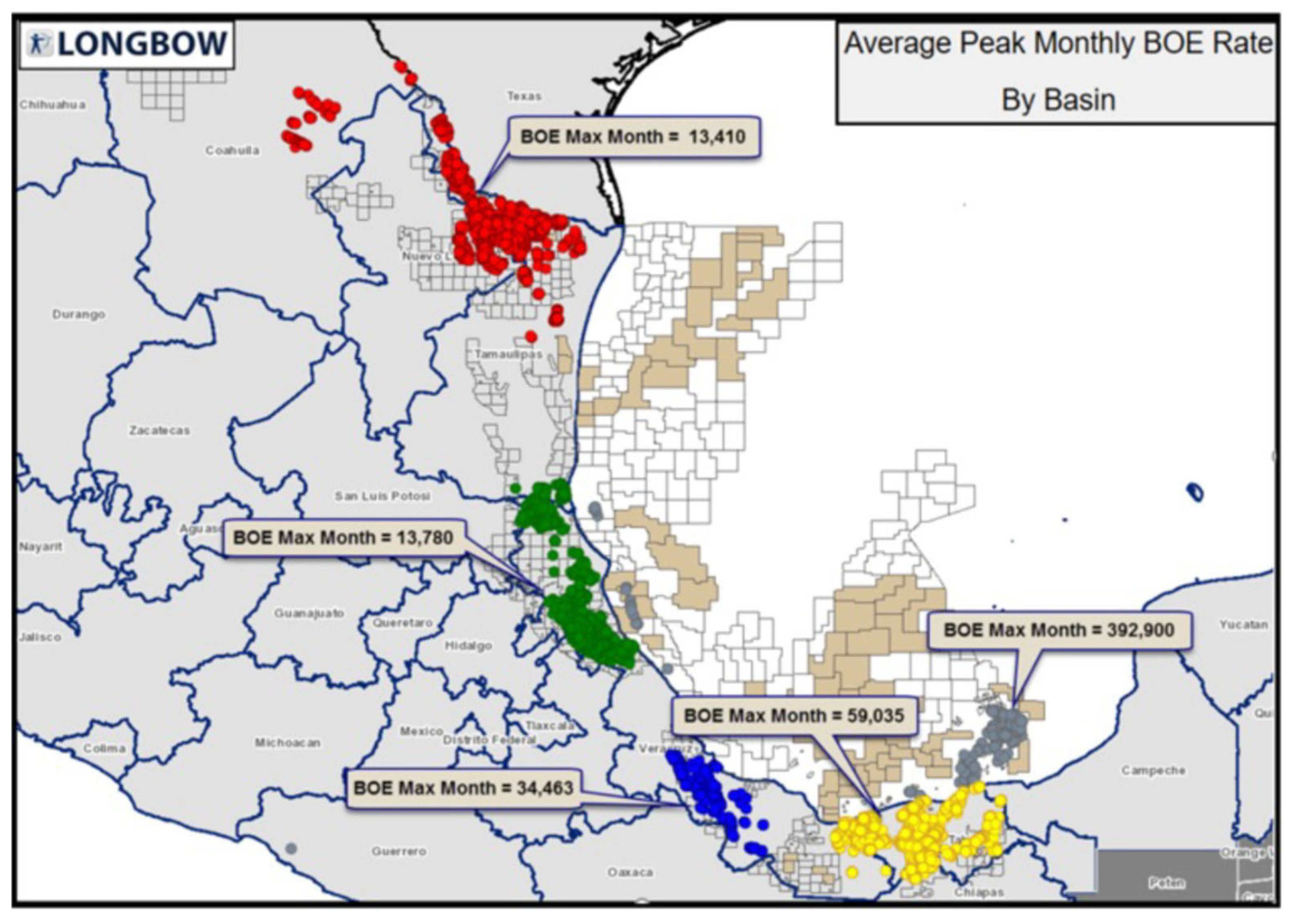
3.1. Oil Production in the Northern Gulf of Mexico
3.2. Oil Production in the Southern Gulf of Mexico
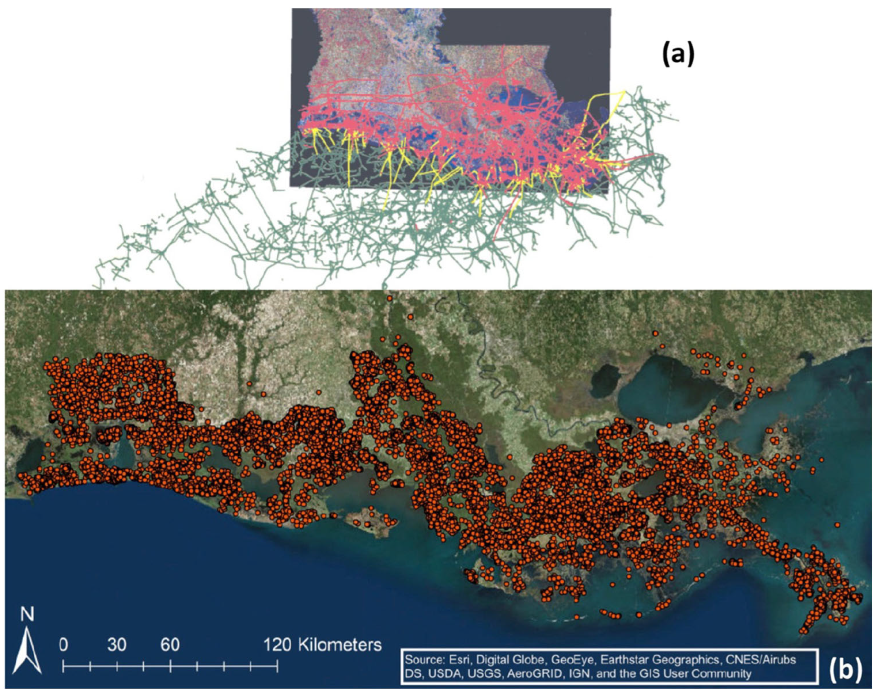
3.3. Impacts of Hydrocarbon Activities on Wetlands and Aquatic Ecosystems of the Gulf of Mexico
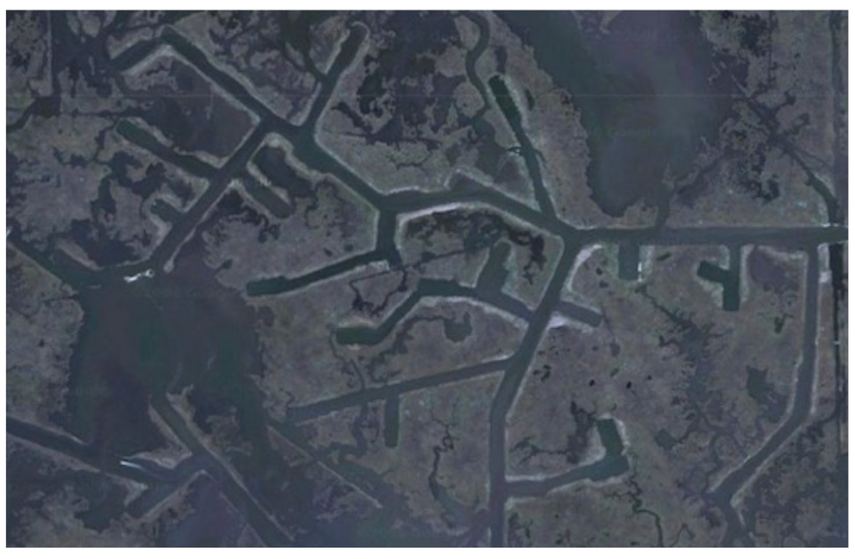
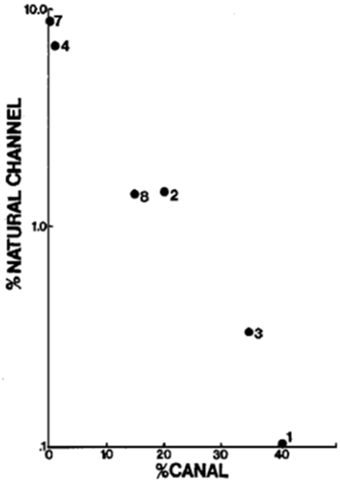
3.3.1. Canals
3.3.2. Spoil Banks
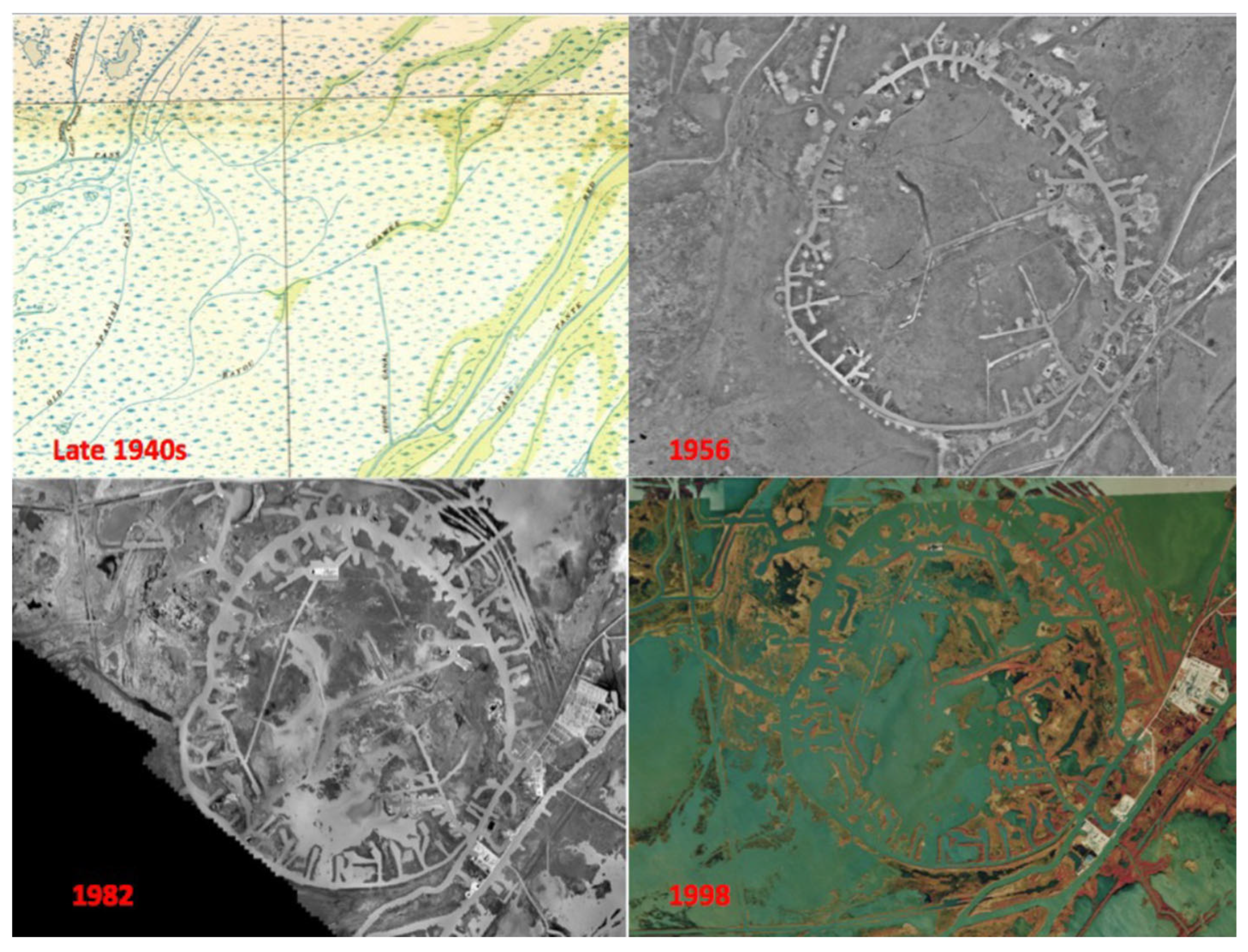
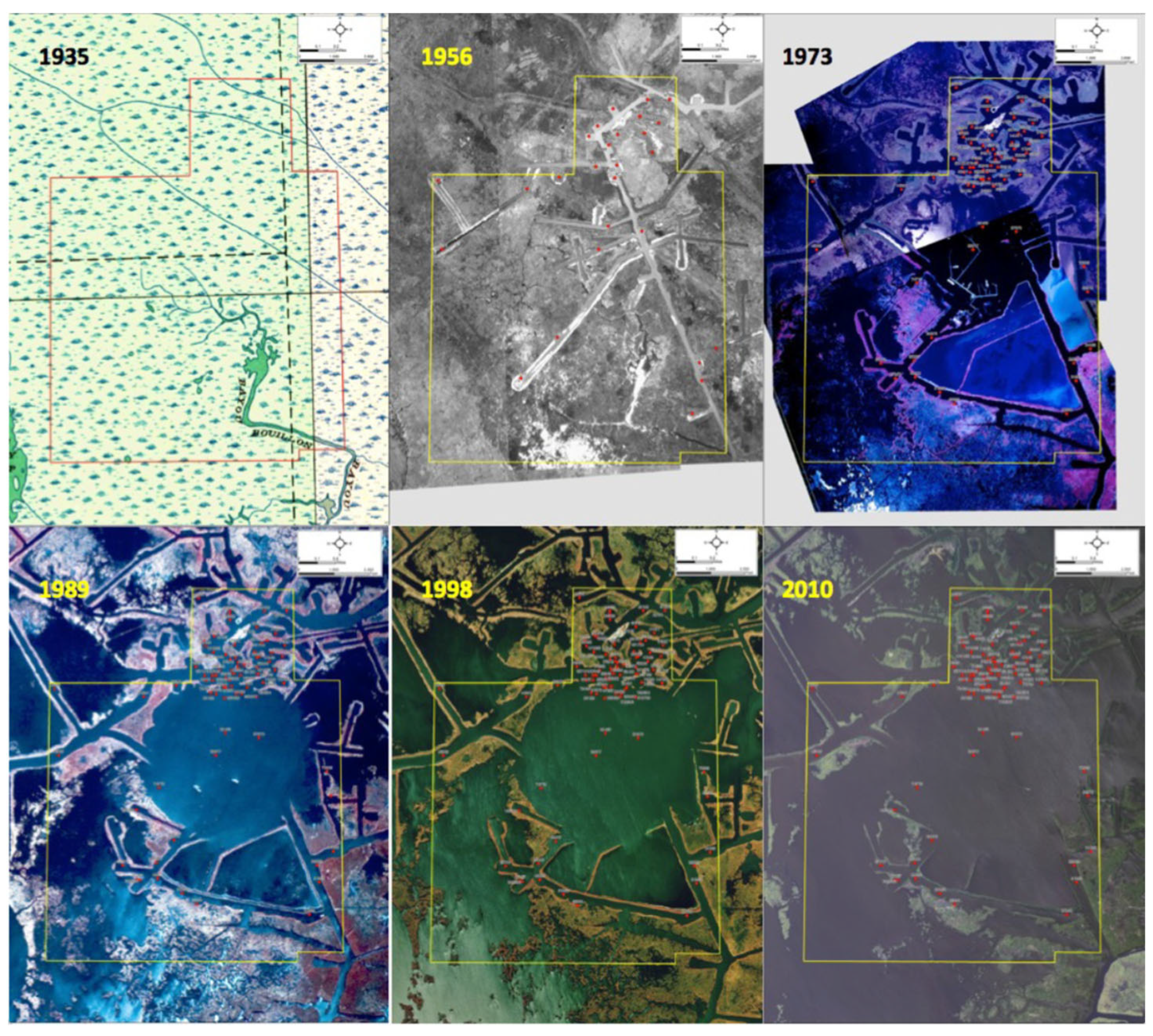
3.3.3. Alteration of Surface Hydrology through Cumulative Impacts
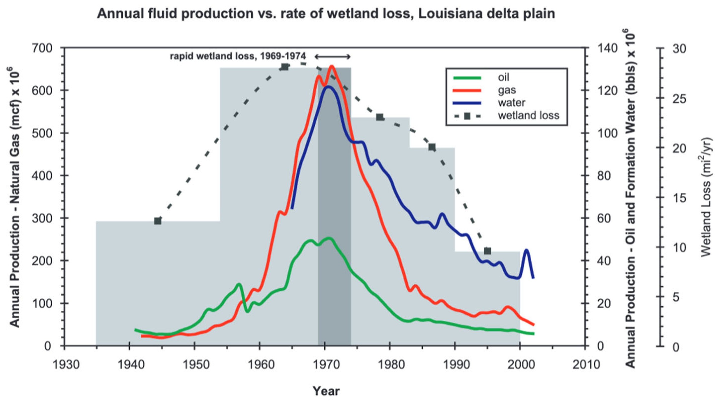
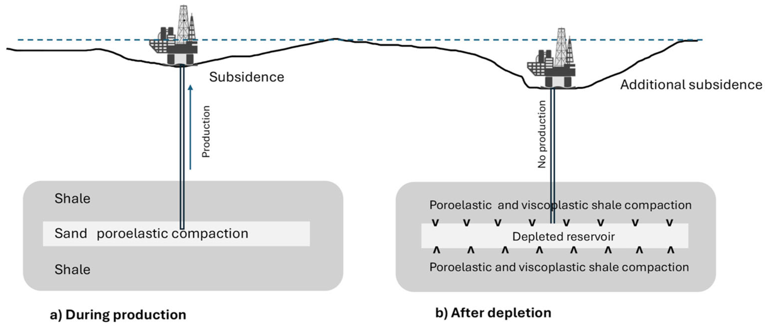
3.3.4. Enhanced Subsidence Due to Petroleum Extraction
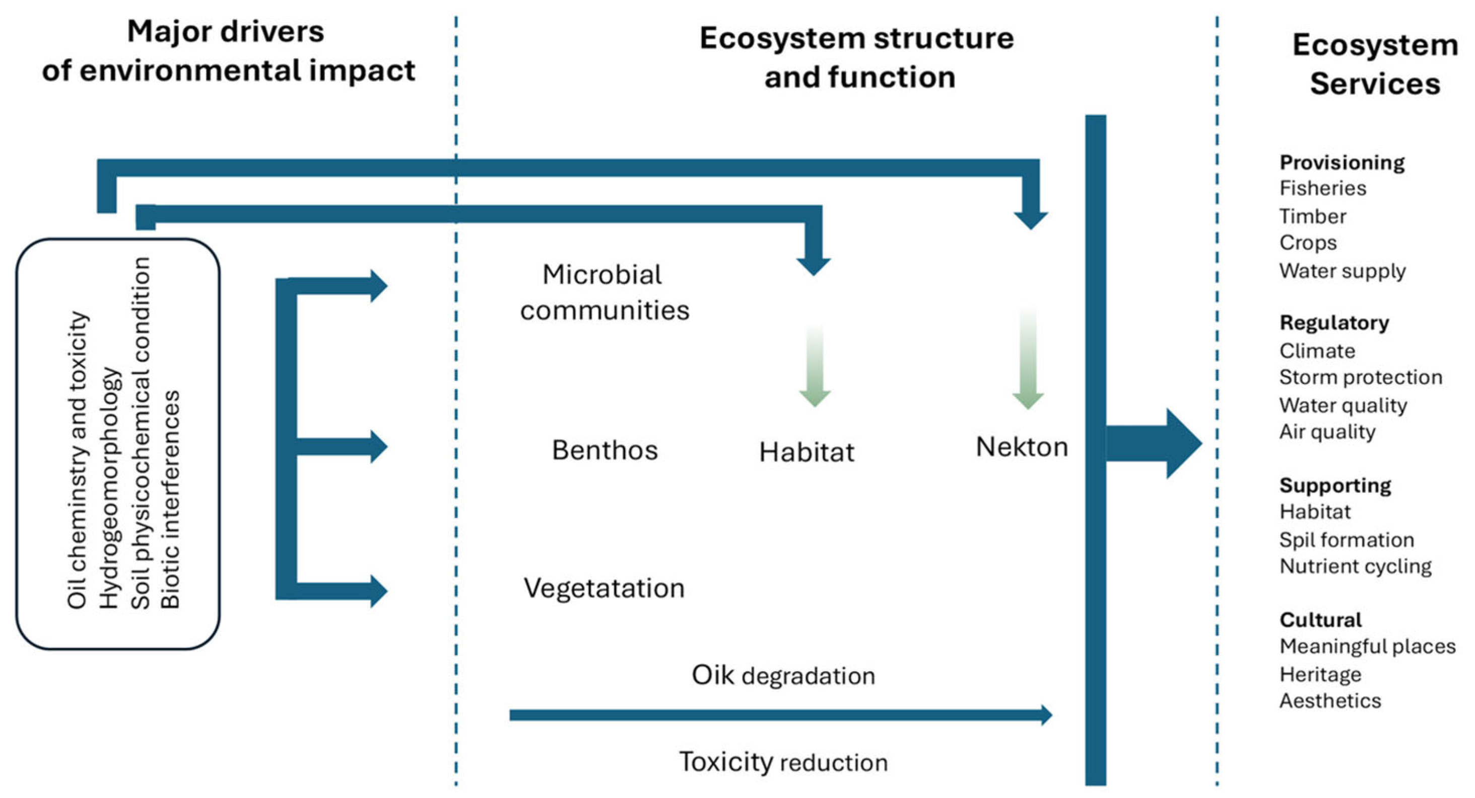
3.4. Impacts of Petroleum on Marine Resources and Ecosystems
Brine Production
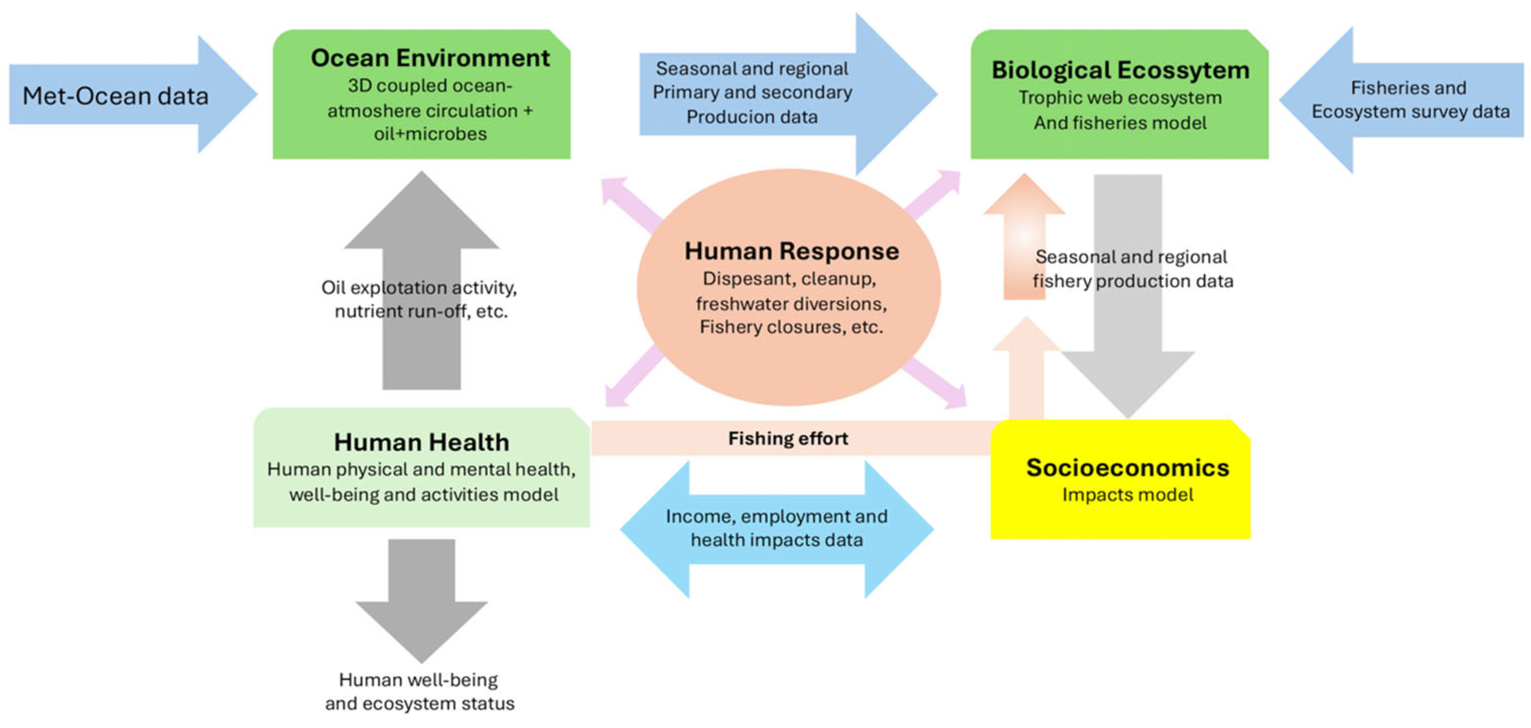
4. Discussion and Conclusions
5. Future Directions
- A clean ocean; eliminating sources of pollution;
- Management for healthy coastal resources;
- Maintaining a productive ocean for sustainable food production and ocean economy (https://oceandecade.org/vision-mission/, accessed on 30 July 2024).
Author Contributions
Funding
Institutional Review Board Statement
Informed Consent Statement
Data Availability Statement
Acknowledgments
Conflicts of Interest
Appendix A
Oil Spills in the Gulf of Mexico

| Oil Spill | Recount | References |
|---|---|---|
| Ixtoc-I well, 1979 | The drilling of the Ixtoc I well began on 1 December 1978, in the southeast Gulf of Mexico Campeche Sound, 94 km northwest of Cd del Carmen. On 3 June 1979, while drilling at 3627 m depth, due to a failure in the drilling fluid circulation, oil and gas accumulated in the pipeline, which produced an explosion. The accident resulted in the collapse of the marine platform and produced a large oil spill and a fire that lasted 280 days, releasing 560 million liters of crude oil. Of the total, 50% was burned, 16% was evaporated, 5.4% was collected, and 28% was dispersed. Marine currents carried the petroleum to the coastal zones of Campeche, Tabasco, Veracruz, Tamaulipas, and Texas. | [123] |
| There was no precedent of an oil spill of such a magnitude. There was no rapid response to control and mitigate the grave pollution to marine waters, resources, and ecosystems. The oil mousse, sheen, and tar balls were carried to the coastal zone, impacting coastal lagoons, wetlands, and seagrass beds. A major factor preventing an environmental assessment of the ecological damages caused by the spill was the lack of previous baseline information to compared to after the oil spill. | [124,125,126] | |
| Tar balls appeared on Texas beaches on 6 August 1979. The heaviest concentrations were between 29 August and 1 September 1979, when the levels of oil on Texas beaches reached 3900 metric tons. The first heavy oiling occurred on South Padre Island on August 24. Mousse patches were found along most of North and South Padre Island beaches during October and were broken up or buried by clean-up crews. In the inlets and lagoons, the only significant oil impact was the oiling of a marsh for 10 days. NOAA found that migratory birds avoided the more heavily oiled beaches, while only 10% of wading and shorebirds were oiled birds. Acute toxicity tests, conducted on subtidal amphipods and zooplankton, suggested that Ixtoc I oil at concentrations measured was not toxic to these species. Toxicity tests on redfish, sea trout, and brown shrimp, the major fishery species in the area, indicated no acute toxicity to adults, but high mortality and deformity rates in juvenile and larval populations. | [127] | |
| Results were obtained during a NOAA research cruise in the area of the Ixtoc-I spill in September 1979 (Atwood and Ferguson 1979). They found that solar radiation was responsible for the production of various photooxidant products that contributed to mousse formation. They also reported that the same oxidant products were formed in the absence of light by in situ bacteria populations that were able to assimilate the oil spill in a couple of weeks | [128] | |
| The Mega Borg, 1990 | It spilled 5.1 million gallons of oil in the Gulf of Mexico, 57 miles south-southeast of Galveston, Texas, following a pump-room explosion and fire. | |
| Two oil tankers collided, 1993 | The Bouchard B155, Balsa 37, and Ocean 255 collided in Tampa Bay, causing the Bouchard to spill 336,000 gallons of No. 6 fuel oil. | |
| 2000 | The Westchester ran aground near Port Sulphur, Louisiana, dumping 567,000 gallons of crude oil into the lower Mississippi River | |
| 2005 | The U.S. Coast Guard estimated that more than 7 million gallons of oil were spilled in the Gulf of Mexico and near-shore areas from multiple sources due to Hurricane Katrina. | |
| 2006 | Seventy-one-thousand barrels of waste oil spilled from a CITGO refinery on the banks of the Calcasieu River, Louisiana. | |
| The Usumacinta platform and the Kab-121 oil well, 2007 | It was reported that when a cold front with winds of 130 km/h traversed Campeche Sound, the Usumacinta and Kab-121 platforms had problems. Bad weather caused the self-elevating Usumacinta platform to collide with the Kab-121 platform, which was drilling the Kab-103 well. This ruptured valve trees, resulting in an oil spill and release of natural gas, which caused several fires. The Kab platform is 32 km from Dos Bocas in the municipality of Tabasco, and 75 km from Cd. del Carmen. In November and December 2007, the platform had various fires that were controlled. On 12 December, PEMEX finally managed to control the oil spill and fires on the platform. Associated with the fires, there was an oil spill of 16.5 million barrels of light crude and 27 million cubic feet of gas. The environmental impact of the burning gas burning was estimated to be 76 tons of SOx and 4260 tons of CO2. Local coastal populations in Tabasco and Campeche were not affected; however, PEMEX paid 16 million pesos to the fishery sector. | [129] |
| 2008 | A barge carrying 419,000 gallons of heavy fuel collided with a 600-foot tanker in the Mississippi River, near New Orleans. Hundreds of thousands of gallons of fuel were spilled. | |
| 2009 | A 458-foot vessel struck a barge in the Houston Ship Channel, spilling 10,500 gallons of oil. In the same year, a supply vessel collided with a Liberian oil tanker, 40 miles offshore of Galveston, Texas, causing 18,000 gallons of oil to spill. | |
| 2010 | January. The Eagle Otome collided with a barge in the Sabine-Neches Waterway, near Port Arthur, Texas, spilling 462,000 gallons of oil. | [130] |
| 2010 | 6 April, A pipeline owned by Cypress Pipe Company—a joint venture between Chevron and BP—broke, spilling 18,000 gallons of oil into the Delta National Wildlife Refuge in Louisiana. | [131] |
| Menadrill Platform 1 2014 | It was reported that an explosion took place on the oil Menadrill 1 platform operated by the Aban Singapur Company, located in the Cantarell complex. That morning, the Akal-Delta complex exploded, and Pemex reported five hours later that the fire was controlled. | [132] |
| Abkatun Alfa Permanente Oil platform, 2015 | It was reported that a fire began at 3:40 a.m. on 1 April 2015 in the Abkatun Permanente platform in Campeche Sound, located 90 km offshore of Campeche and Tabasco. It was reported that Greenpeace had access to a satellite image from 2 April at 10:15 a.m., a day after the explosion; in the image, several fire-extinguishing ships and a 4 km sheen on the water moving in the west-north-west direction can be observed. | [133,134,135] |
| Oil spill in Cayo Arcas, 2019 | It was reported on 2 November that, beginning 4 October, there was an oil spill in the Maritime Terminal of Cayo Arcas, located 3 km south of the Cayo Arcas Coral Reef System. On 4 October, several researchers from UNACAR reported that satellite images (Radar of Synthetic opening, Sentinel 1) indicated an oil spill originated near one of the buoys of the terminal, covering an area of 220 ha. By 7 October, the area had grown to 4500 ha. On October 18, researchers from UNACAR met with the authorities and reported that there were dozens of oiled ducks (Sula dactylara) and hundreds of young marine turtles (Chelonia mydas) in the polluted zone. There was also a large area of oiled sand and rocky beaches. There was no information about coral reef and benthic communities. According to the Mexican Navy, UNACAR staff cleaned the oiled fauna between 9 and 11 October, and made a map of the oil spill, which reached 4484 ha. | [136] |
| Self-Elevated Troll Solution platform, 2015 | A note was published on 5 May about an accident involving the self-elevated Troll Solution platform, when one of its “legs” collapsed, tilting the structure and causing it to sink. The incident started around 7 a.m. and was caused by incorrect positioning of the platform on unstable sediments. ASEA confirmed that there was no oil spill since it was a maintenance structure. | [137] |
| Ku Charly platform, 2021 | Chim (2021) reported that, on 2 July, there was a fire 400 m from the Ku-Charly platform, operated by the Integral Production Active Ku Maloob Zaap, and that it was out of control for 8 h. PEMEX called this “Fire Eye”, which was caused by a valve in the marine pipeline that broke, and oil came to the surface causing a fire. The incident happened at 4 a.m. near the Ku Sierra platform and threatened to expand to other marine oil complexes. | [138] |
| Ku Maloob Zaap platform, 2021 | García (2021) reported that, at noon, 22 August, there was a smoke column from the marine structures of PEMEX. At 4 p.m., they confirmed a fire at E Ku A2 in the Ku Maloob Zaap producer complex. | [139] |
| Akal Charly platform, 2022 | It was published that, on 12 August, there was a gas leak in a pipeline of the Akal Charly platform in the Cantarell complex, located 78 km from Cd del Carmen. PEMEX sent ships to combat the fire and specialized divers to control the leak. | [140] |
| Nohoch-Alfa platform, 2023 | It was reported that, on 7 July, the Nohoch-Alfa platform exploded. Several non-governmental organizations (NGOs) reported that several days prior to the Nohoch-Alfa platform explosion (7 July), there was a report of an oil spill from another platform in the zone. Satellite images showed an oil spill from the Balam platform that likely started on 4 July. On 12 July, the oil spill covered about 400 km2. NGOs reported that this was not the only oil spill, since a review of the same zone in June showed that another oil spill covered an area of 270 km2, and on 2 March, another spill of 55 square kilometers was reported. In a press conference, Tamburini explained that if 10% of the reported areas have an oil cover of 0.1 mm thick, the total volume of spilled oil was 7000 cubic meters. | [141] |
| Ek Balam oil fields, 2023 | On 23 July, UNAM reported that two spills from the from the Ek Balam caused an oil spill of 467 km2 (12 July). Experts from the Geography Institute, UNAM, and from the National Laboratory for Earth Observation, analyzed the oil spill with radar images to estimate the size of the affected areas. Gómez Rodríguez said that models of marine currents predict that this oil will reach the coasts of Veracruz, Tamaulipas, and probably the USA. It was reported that the oil spill had already affected the beaches of Tabasco and Veracruz, and NGOs found marine fauna oiled and dead. Images of hydrocarbon residues on the coasts were shown, and tourists and locals complained that petroleum soiled their clothes and shoes. Fundación Caretta found, in Tamaulipas and Veracruz, hydrocarbons on the beaches and dead, oiled marine turtles. | [142,143,144] |
| 22 March 2024 | NGOs detected an oil spill coming from the Akal-B marine platform since the 22nd of March, covering a surface of 390 km2; this adds to an increment of 152% in the accident’s frequency. | [145,146,147] |
References
- Day, J.W.; Hall, C.; Klitgaard, K.; Gunn, J.; Ko, J.; Burger, J. The Coming Perfect Storm: Diminishing Sustainability of Coastal Human-natural Systems in the Anthropocene; Cambridge University Press: Cambridge, UK, 2023. [Google Scholar] [CrossRef]
- Day, J.; Anthony, E.; Costanza, R.; Edmonds, D.; Gunn, J.; Hopkinson, C.; Mann, M.; Morris, J.; Osland, M.; Quirk, T.; et al. Coastal Wetlands in the Anthropocene. Annu. Rev. Environ. Resour. 2024, 49. [Google Scholar] [CrossRef]
- Day, J.; Hunter, R.; Clark, H. Energy Production in the Mississippi River Delta: Impacts on Coastal Ecosystems and Pathways to Restoration; Lecture Notes in Energy 43; Springer: Cham, Switzerland, 2022. [Google Scholar]
- Vazquez Botello, A.; de la Lanza Espino, G.; Villanueva Fragoso, S.; Ponce Velez, G. Pollution Issues in Coastal Lagoons in the Gulf of Mexico. In Lagoon Environments Around the World—A Scientific Perspective; IntechOpen: Rijeka, Croatia, 2020. [Google Scholar] [CrossRef]
- NOOA. Gulf of Mexico Region. Available online: https://www.noaa.gov/regional-collaboration-network/regions-gulf-of-mexico/noaa-in-gulf-of-mexico-region (accessed on 15 July 2024).
- Day, J.W.; Yanez-Arancibia, A.; Kemp, W.M. Human Impact and Management of Coastal and Estuarine Ecosystems. In Estuarine Ecology; Wiley: Hoboken, NJ, USA, 2013; pp. 483–495. [Google Scholar]
- Caso, M.; Pisanty, I.; Ezcurra, E. Diagnóstico Ambiental del Golfo de México. 2004. Available online: https://www.researchgate.net/profile/Erick-Baqueiro-Cardenas/publication/222099428_13_Baqueiro_C_E_2005_Estado_actual_de_los_recursos_malacologicos_del_Golfo_de_Mexico_En_Diagnostico_ambiental_del_Golfo_de_Mexico_Caso_M_I_Pisnaty_y_E_Ezcura_Eds_SEMARNAT_INE_232-260/links/5977a72b0f7e9b277721cdd8/13-Baqueiro-C-E-2005-Estado-actual-de-los-recursos-malacologicos-del-Golfo-de-Mexico-En-Diagnostico-ambiental-del-Golfo-de-Mexico-Caso-M-I-Pisnaty-y-E-Ezcura-Eds-SEMARNAT-INE-232-260.pdf (accessed on 15 July 2024).
- de la Lanza Espino, G.; Hernández Pulido, S. Ambiente, Biología, Sociedad, Manejo y Legislación de Sistemas Costeros Mexicanos; Plaza y Valdés, S.A. de C.V: Ciudad de Mexico, Mexico, 2011. [Google Scholar]
- EPA. Gulf Coast Estuaries: National Coastal Condition Assessment. Available online: www.epa.gov (accessed on 15 July 2024).
- Deegan, L.A.; Day, J.W.; Gosselink, J.G.; Yáñez-Arancibia, A.; Chávez, G.S.; Sánchez-Gil, P. Relationships among Physical Characteristics, Vegetation Distribution and Fisheries Yield in Gulf of Mexico Estuaries. In Estuarine Variability; Elsevier: Amsterdam, The Netherlands, 1986; pp. 83–100. [Google Scholar] [CrossRef]
- Broadus, J.; Lamourie, M.; Geyer, R. Gulf of Mexico. Encyclopedia Britannica. Available online: www.britannica.com/place/Gulf-of-Mexico (accessed on 15 July 2024).
- García, K. Pemex Cierra El 2023 Con 91,000 Barriles Más. El Economista. 2024. Available online: https://www.eleconomista.com.mx/empresas/Pemex-cierra-el-2023-con-91000-barriles-diarios-mas-20240126-0075.html#:~:text=La%20producción%20de%20hidrocarburos%20líquidos,público%20la%20petrolera%20del%20Estado (accessed on 15 July 2024).
- CONAHCYT. Reservas de Crudo en México. Available online: https://energia.conahcyt.mx/planeas/hidrocarburos/produccion-crudo (accessed on 15 July 2024).
- U.S. Departament of the Interior. Bureau of Ocean Energy Management. Available online: www.boem.gov/regions/gulf-mexico-ocs-region/oil-and-gas-gulf-mexico (accessed on 19 July 2024).
- Dahl, T.E. Status and Trends of Wetlands in the Conterminous United States 2004 to 2009; U.S. Fish and Wildlife Service: Washington, DC, USA, 2004.
- Day, J.W.; Clark, H.C.; Chang, C.; Hunter, R.; Norman, C.R. Life Cycle of Oil and Gas Fields in the Mississippi River Delta: A Review. Water 2020, 12, 1492. [Google Scholar] [CrossRef]
- McKinney, L.; Shepherd, J.G.; Wilson, C.A.; Hogarth, W.T.; Chanton, J.; Murawski, S.A.; Sandifer, P.A.; Sutton, T.; Yoskowitz, D.; Wowk, K.; et al. The Gulf of Mexico an Overview. 2021. Volume 34. Available online: https://clarivate.com/webofsciencegroup/solutions/web-of-science/ (accessed on 30 July 2024).
- Contreras, F.; Castañeda, O. Coastal Lagoons and Estuaries of the Gulf of Mexico: Toward the Establishment of Ecological Indicators. In Environmental Analysis of the Gulf of Mexico; Caso, M., Pisanty, I., Ezcurra, E., Eds.; Texas A&M University: College Station, TX, USA, 2004; pp. 230–261. [Google Scholar]
- Cabrera, M.; Seijo, J.; Euan, J.; Pérez, E. Economic Values of Ecological Services from a Mangrove Ecosystem. Intercoast Netw. 1998, 32, 1–2. [Google Scholar]
- Soto-Galera, E.; Piera, J.; López, P. Spatial and Temporal Land Cover Changes in Terminos Lagoon Reserve, Mexico. Rev. Biol. Trop. Int. J. Trop. 2010, 58, 565–575. [Google Scholar] [CrossRef]
- The National Academies Press. Characteristics of the Mississippi River System. In Mississippi River Water Quality and the Clean Water Act; The National Academies Press: Washington, DC, USA, 2008; pp. 21–64. [Google Scholar]
- Mitsch, W.; Day, J.; Gilliam, W.; Groffman, P.; Hey, D.; Randall, G.; Wang, N. Reducing Nitrogen Loading to the Gulf of Mexico from the Mississippi River Basin: Strategies to Counter a Persistent Ecological Problem. Bioscience 2001, 51, 373–388. [Google Scholar] [CrossRef]
- Batker, D.; de la Torre, I.; Costanza, R.; Day, J.; Sweeden, P.; Boumans, R.; Bagstad, K. The Threats to the Value of Ecosystem Goods and Services of the Mississippi Delta. In Perspectives on the Restoration of the Mississippi Delta; Day, J., Kemp, P., Freeman, A., Muth, D., Eds.; Springer: Berlin/Heidelberg, Germany, 2014; pp. 155–174. [Google Scholar]
- Blum, M.; Rahn, D.; Frederick, B.; Polanco, S.M. Land Loss in the Mississippi River Delta: Role of Subsidence, Global Sea-Level Rise, and Coupled Atmospheric and Oceanographic Processes. Glob. Planet Chang. 2023, 222, 104048. [Google Scholar] [CrossRef]
- Day, J.W.; Boesch, D.F.; Clairain, E.J.; Kemp, G.P.; Laska, S.D.; Mitsch, W.J.; Orth, K.; Mashriqui, H.; Reed, D.J.; Shabman, L.; et al. Restoration of the Mississippi Delta: Lessons from Hurricanes Katrina and Rita. Science 2007, 315, 1679–1684. [Google Scholar] [CrossRef]
- Day, J.W.; Shaffer, G.P.; Cahoon, D.R.; DeLaune, R.D. Canals, Backfilling and Wetland Loss in the Mississippi Delta. Estuar Coast Shelf Sci. 2019, 227, 106325. [Google Scholar] [CrossRef]
- Ko, J.Y.; Day, J.W. A Review of Ecological Impacts of Oil and Gas Development on Coastal Ecosystems in the Mississippi Delta. Ocean Coast. Manag. 2004, 47, 597–623. [Google Scholar] [CrossRef]
- Hester, M.W.; Willis, J.M.; Rouhani, S.; Steinhoff, M.A.; Baker, M.C. Impacts of the Deepwater Horizon Oil Spill on the Salt Marsh Vegetation of Louisiana. Environ. Pollut. 2016, 216, 361–370. [Google Scholar] [CrossRef]
- NOOA. Larger-Than-Average Gulf of Mexico “Dead Zone” Measured. Available online: https://www.noaa.gov/news-release/larger-than-average-gulf-of-mexico-dead-zone-measured (accessed on 19 July 2024).
- NASA. Laguna de Terminos. Earth Obervatory. Available online: https://earthobservatory.nasa.gov/images/90893/laguna-de-terminos (accessed on 19 July 2024).
- Yáñez-Arancibia, A.; Day, J. Ecological Characterization of Terminos Lagoon, a Tropical Lagoon-Estuarine System in the Southern Gulf of Mexico. In Proceedings of the Internationl Symposium on Coastal Lagoons, Bardeaux, France, 8–14 September 1982; pp. 431–440. [Google Scholar]
- Sánchez-Rucobo y Huerdo, C.; Allende-Arandía, M.E.; Figueroa-Espinoza, B.; García-Caballero, E.; Esparza, A.C.R.; Appendini, C.M. Hybrid Renewable Energy System for Terminos Lagoon, Campeche, Mexico. Energies 2023, 16, 3972. [Google Scholar] [CrossRef]
- Ramos Miranda, J.; Mouillot, D.; Lopez, A.S.; Do Chi, T.; Hernández, D.F. How Much Variation Can Be Explained by Seasonal, Spatial and Environmental Effects in Nekton Assemblages of the Terminos Lagoon? Aquat. Conserv. Mar. Freshw. Ecosyst. 2008, 18, 508–517. [Google Scholar] [CrossRef]
- Yánez-Arancibia, A.; Lara-Domínguez, A.; Rojas Galaviz, J.L.; Zárate Lomeli, D.; Villalobos Zapata, G.J.; Sánchez-Gil, P. Integrating Science and Management on Coastal Marine Protected Areas in the Southern Gulf of Mexico. Ocean Coast. Manag. 1999, 42, 319–344. [Google Scholar] [CrossRef]
- Yáñez-Arancibia, A.; Day, J. Ecosystem Functioning: The Basis for Sustainable Management of Términos Lagoon, Campeche, Mexico. 2005. Available online: https://www.crc.uri.edu/download/24_Monitoring_recommendations_Terminos.pdf (accessed on 19 July 2024).
- Soria-Barreto, M.; Pérez-Ceballos, R.; Zaldívar-Jiménez, A.; Fernández, R.G. Assessment of Aquatic Food Web and Trophic Niche as a Measurement of Recovery Function in Restored Mangroves in the Southern Gulf of Mexico. PeerJ 2023, 11, e15422. [Google Scholar] [CrossRef] [PubMed]
- Harwell, M.A.; Gentile, J.H.; McKinney, L.D.; Tunnell, J.W.; Dennison, W.C.; Kelsey, R.H.; Stanzel, K.M.; Stunz, G.W.; Withers, K.; Tunnell, J. Conceptual Framework for Assessing Ecosystem Health. Integr. Environ. Assess. Manag. 2019, 15, 544–564. [Google Scholar] [CrossRef] [PubMed]
- Oesterwind, D.; Rau, A.; Zaiko, A. Drivers and Pressures—Untangling the Terms Commonly Used in Marine Science and Policy. J. Environ. Manag. 2016, 181, 8–15. [Google Scholar] [CrossRef]
- Azuz-Adeath, I.; Rivera-Arriaga, E. Descripción de La Dinámica Poblacional En La Zona Costera Mexicana Durante El Periodo 2000–2005. Papeles Población 2009, 15, 75–107. [Google Scholar]
- INEGI. Producto Interno Bruto Por Entidad Federativa 2022. 2022. Available online: https://www.inegi.org.mx/contenidos/saladeprensa/boletines/2023/PIBEF/PIBEF2022.pdf (accessed on 19 July 2024).
- NMFS. Fisheries of the United States 2017 Current Fishery Statics No. 2017. 2018. Available online: https://www.fisheries.noaa.gov/resource/document/fisheries-united-states-2017-report (accessed on 19 July 2024).
- CNIH. Centro Nacional de Información de Hidrocarburos. Available online: www.gob.mx/cnh (accessed on 19 July 2024).
- Morton, R.A.; Bernier, J.C.; Barras, J.A.; Morton, R.A.; Bernier, J.C.; Barras, J.A.; Ferina, N.F. Historical Subsidence and Wetland Loss in the Mississippi Delta Plain. 2005. Volume 55. Available online: https://www.researchgate.net/publication/265318794 (accessed on 30 July 2024).
- Turner, R.E.; McClenachan, G. Reversing Wetland Death from 35,000 Cuts: Opportunities to Restore Louisiana’s Dredged Canals. PLoS ONE 2018, 13, e0207717. [Google Scholar] [CrossRef]
- IHS Energy Group. PI Dwights Plus U.S. Production Data on CD; IHS Energy Group: Englewood, CO, USA, 2003. [Google Scholar]
- Morton, R.A.; Bernier, J.C.; Barras, J.A. Evidence of Regional Subsidence and Associated Interior Wetland Loss Induced by Hydrocarbon Production, Gulf Coast Region, USA. Environ. Geol. 2006, 50, 261–274. [Google Scholar] [CrossRef]
- Gagliano, S. Assessment of Environmental Impacts Associated with Oil and Gas Exploration and Development in the Bully Camp Oil and Gas Field Lafourche Parish Louisiana; Vintage Assets, Inc.: Plaquemines Parish, LA, USA, 2017. [Google Scholar]
- Pulido Piñeyro, F. La Historia de la Industria Petrolera Mexicana En Una Gráfica. Available online: www.linkedin.com/pulse/la-historia-de-industria-petrolera-mexicana-en-una-pulido-pi%C3%B1eyro (accessed on 20 July 2024).
- Zenteno Escutia, P. Transformación Político-Territorial, Infalibles En El Aprovechamiento Del Petróleo En La Bahía de Campeche. Rev. Geográfica 2013, 153, 153–166. [Google Scholar]
- IMCO. Pemex en la Mira al Primer Trimestre de 2024. Centro de Investigación de Política Pública. Available online: www.imco.org.mx (accessed on 20 July 2024).
- BOEM. Oil and Gas—Gulf of Mexico. Bureau of Ocean Energy Management. Available online: www.boem.gov (accessed on 21 July 2024).
- Mirenda, T. A Review of Mexico Historical Production Data at a Basin Level. Available online: www.linkedin.com/pulse/review-mexico-historical-production-data-basin-level-ted-mirenda (accessed on 21 July 2024).
- Cahoon, D.R.; Turner, R.E. Accretion and Canal Impacts in a Rapidly Subsiding Wetland I1. Feldspar Marker Horizon Technique. Estuaries 1989, 12, 260–268. [Google Scholar] [CrossRef]
- Bass, A.; Turner, R. Relationship between Salt Marsh Loss and Dredged Canals in Three Louisiana Estuaries. J. Coast. Res. 1997, 13, 895–903. [Google Scholar]
- Day, J.W.; Shaffer, G.P.; Britsch, L.D.; Reed, D.J.; Hawes, S.R.; Cahoon, D. Pattern and Process of Land Loss in the Mississippi Delta: A Spatial and Temporal Analysis of Wetland Habitat Change. Estuaries 2000, 23, 425–438. [Google Scholar] [CrossRef]
- Gould, H.; Mc Farlan, E. Geologic History of the Chenier Plain, Southwestern Louisiana. Trans. Gulf Coast Assoc. Geol. Soc. 1959, 9, 261–270. [Google Scholar]
- Roberts, B. The Effect of Sulfur Deposition on Gaswell Inflow Performance. SPE Reserv. Eng. 1997, 12, 118–123. [Google Scholar] [CrossRef]
- Penland, S.; Suter, J. The Geomoerphology of the Mississippi River Cheiner Plan. Mar. Geol. 1989, 90, 231–240, 243–258. [Google Scholar] [CrossRef]
- Blum, M. RE Sheriff Lecture: The Mississippi delta region: Past, present, and future. Annu. Rev. Earth Planet. Sci. 2012, 40, 655–683. [Google Scholar] [CrossRef]
- Turner, R.E.; Cahoon, D.R. Causes of Wetland Loss in the Coastal Central Gulf of Mexico. Volume I: Executive Summary. 1987. Available online: https://espis.boem.gov/final%20reports/3778.pdf (accessed on 21 July 2024).
- USACE. LCA Science Board Provides Diversion Guidance Document. 2004. Available online: https://www.mvd.usace.army.mil/Portals/52/docs/SandT/LCA/Dean%20and%20Wells%20Final%20Guidance%20Document.pdf (accessed on 21 July 2024).
- Rabalais, N.N.; Mckee, B.A.; Reed, D.J.; Means, J.C. Fate and Effects of Produced Water Discharges in Coastal Louisiana, Gulf of Mexico, USA. In Produced Water. Environmental Science Research; Ray, J., Engelhardt, F., Eds.; Plenum Press: New York, NY, USA, 1992; Volume 46. [Google Scholar]
- Neto, A.G.; Costa, C.S.B. Survival and Growth of the Dominant Salt Marsh Grass Spartina Alterniflora in an Oil Industry Saline Wastewater. Int. J. Phytoremediat. 2009, 11, 640–650. [Google Scholar] [CrossRef]
- An Assessment of Produced Water Impacts to Low-Energy Brackish Water Systems in Southeast Louisiana. 1990. Available online: https://deq.louisiana.gov/assets/docs/Water/StPeStudy.pdf (accessed on 21 July 2024).
- Olea, R.A.; Coleman, J.L. A Synoptic Examination of Causes of Land Loss in Southern Louisiana as Related to the Exploitation of Subsurface Geologic Resources. J. Coast. Res. 2014, 30, 1025–1044. [Google Scholar] [CrossRef]
- Ko, J.; Day, J.; Lane, R.; Day, J. A Comparative Evaluation of Money Based and Energy-Based Cost-Benefit Analyses of Tertiary Municipal Wastewater Treatment Using Forested Wetlands vs. Sand Filtration in Louisiana. Ecol. Econ. 2004, 49, 331–347. [Google Scholar] [CrossRef]
- Sasser, C.E.; Dozier, M.D.; Gosselink, J.G.; Hill, J.M. Spatial and Temporal Changes in Louisiana’s Barataria Basin Marshes, 1945–1980. Environ. Manag. 1986, 10, 671–680. [Google Scholar] [CrossRef]
- Wang, F.C. Dynamics of Saltwater Intrusion in Coastal Channels. J. Geophys. Res. Oceans 1988, 93, 6937–6946. [Google Scholar] [CrossRef]
- Turner, R.E.; Rao, Y.S. Relationships Between Wetland Fragmentation and Recent Hydrologic Changes in a Deltaic Coast. Estuaries 1990, 13, 272–281. [Google Scholar] [CrossRef]
- Shaffer, G.P.; Wood, W.B.; Hoeppner, S.S.; Perkins, T.E.; Zoller, J.; Kandalepas, D. Degradation of Baldcypress–Water Tupelo Swamp to Marsh and Open Water in Southeastern Louisiana, U.S.A.: An Irreversible Trajectory? J. Coast. Res. 2009, 54, 152–165. [Google Scholar] [CrossRef]
- Turner, R. Relationship between Canal and Levee Density and Coastal Land Loss in Louisiana. 1987. Available online: https://books.google.com.mx/books?hl=es&lr=&id=LsnD2dVlz4kC&oi=fnd&pg=PR7&dq=71.%09Turner,+R.+Relationship+between+Canal+and+Levee+Density+and+Coastal+Land+Loss+in+Louisiana%3B+1987.&ots=9f92LtvzCI&sig=RhUHvRFR6lWlLifcs8YyKTWC_X8#v=onepage&q&f=false (accessed on 21 July 2024).
- Reed, D. The Response of Coastal Marshes to Seas Level Rise: Survival of Submergence? Earth Sci. Process. Landf. 1995, 20, 39–48. [Google Scholar] [CrossRef]
- Gagliano, S.; Wicker, K. Processes of Wetland Erosion in the Mississippi River Deltaic Plain. In Marsh Management in Coastal Louisiana: Effects and Issues-Proceedings of a Symposium; U.S. Fish and Wildlife Service and Louisiana Department of Natural Resources; 1989; Volume 22, pp. 28–48. Available online: https://books.google.com.mx/books?hl=es&lr=&id=chESAAAAYAAJ&oi=fnd&pg=PA28&dq=73.%09Gagliano,+S.%3B+Wicker,+K.+Processes+of+Wetland+Erosion+in+the+Mississippi+River+Deltaic+Plain.+In+Marsh+Management+in+Coastal+Louisiana:+Effects+and+Issues-Proceedings+of+a+Symposium%3B+U.S.+Fish+and+Wildlife+Service+and+Louisiana+Department+of+Natu-ral+Resources,+Ed.%3B+1989%3B+Volume+22,+pp.+28–48.&ots=5k3mh5QzpO&sig=yJQ-wE7KjEiwZ6l1l8yCnENusVo#v=onepage&q&f=false (accessed on 21 July 2024).
- Mendelssohn, I.A.; Mckee, K.L. Spartina Alterniflora Die-Back in Louisiana: Time-Course Investigation of Soil Waterlogging G Effects. J. Ecol. 1988, 76, 509–521. [Google Scholar] [CrossRef]
- Mckee, K.L.; Mendelssohn, I.A. Response of a Freshwater Marsh Plant Community to Increased Salinity and Increased Water Level. Aquat. Bot. 1989, 34, 301–316. [Google Scholar] [CrossRef]
- Mendelssohn, I.A.; Morris, J.T. Eco-Physiological Controls on the Productivity of Spartina Alterniflora Loisel. In Concepts Controversies in Tidal Marsh Ecology; Weinstein, M., Kreeger, D., Eds.; Kluwer Academic Publishers: Boston, MA, USA, 2000; pp. 59–80. [Google Scholar]
- Day, J.W.; Kemp, G.P.; Reed, D.J.; Cahoon, D.R.; Boumans, R.M.; Suhayda, J.M.; Gambrell, R. Vegetation Death and Rapid Loss of Surface Elevation in Two Contrasting Mississippi Delta Salt Marshes: The Role of Sedimentation, Auto compaction and Sea-Level Rise. Ecol. Eng. 2011, 37, 229–240. [Google Scholar] [CrossRef]
- Nyman, J.A.; Delaune, R.D.; Patrick, W.H. Wetland Soil Formation in the Rapidly Subsiding Mississippi River Deltaic Plain: Mineral and Organic Matter Relationships. Estuar. Coast. Shelf Sci. 1990, 31, 57–69. [Google Scholar] [CrossRef]
- Energy Vanguard. Oil Industry Canals in South Louisiana. Available online: https://www.energyvanguard.com/blog/the-real-tragedy-of-the-oil-industry-in-louisiana/attachment/attachment-oil-industry-canals-in-south-louisiana/ (accessed on 16 September 2024).
- Day, R.H.; Holz, R.K.; Day, J.W. An Inventory of Wetland Impoundments in Zone of Louisiana, USA: Historical Trends the Coastal. Environ. Manag. 1990, 14, 229–240. [Google Scholar] [CrossRef]
- Taylor, N.C.; Day, J.W.; Neusaenger, G.E. Ecological Characterization of Jean Lafitte National Historical Park, Louisiana: Basis for a Management Plan. 1989; pp. 247–277. Available online: https://books.google.com.mx/books?hl=es&lr=&id=chESAAAAYAAJ&oi=fnd&pg=PA247&dq=82.%09Taylor,+N.C.%3B+Day,+J.W.%3B+Neusaenger,+G.E.+Ecological+Characterization+of+Jean+Lafitte+National+Historical+Park,+Louisiana:+Basis+for+a+Management+Plan%3B+1989.&ots=5k3mh5QCkU&sig=VV8LwB_eqFcY_QHDg7B_eCVzPMU#v=onepage&q&f=false (accessed on 16 September 2024).
- Reed, D.J. Effect of Weirs on Coastal Marshes Sediment Deposition in Louisiana. Environ. Manag. 1992, 16, 55–65. [Google Scholar] [CrossRef]
- Reedt, D.J.; Cahoon, D.R. The Relationship Between Marsh Surface Topography, Hydroperiod, and Growth of Spartina alterniftora in a Deteriorating Louisiana Salt Marsh. J. Coast. Res. 1992, 8, 77–87. [Google Scholar]
- Rogers, D.R.; Rogers, B.D.; Herke, W.H. Effects of a Marsh Management Plan on Fishery Communities in Coastal Louisiana. Wetlands 1992, 12, 53–62. [Google Scholar] [CrossRef]
- Cahoon, D.R. Recent Accretion in Two Managed Marsh Impoundments in Coastal Louisiana. Ecol. Appl. 1994, 4, 166–176. [Google Scholar] [CrossRef]
- Asano, T.; Member, I. Sediment Transport under Sheet-Flow Conditions. J. Waterw. Port Coast. Ocean. Eng. 1995, 121, 239–246. [Google Scholar] [CrossRef]
- Gascuel-Odoux, C.; Cros-Cayot, S.; Durand, P. Spatial Variations of Sheet Flow and Sediment Transport on an Agricultural Field. Earth Surf. Process. Landf. 1996, 21, 843–851. [Google Scholar] [CrossRef]
- Reed, D.J.; Wilson, L. Coast 2050: A New Approach to Restoration of Louisiana Coastal Wetlands. Phys. Geogr. 2004, 25, 4–21. [Google Scholar] [CrossRef]
- Boumans, R.M.; Day, J.W. Effects of Two Louisiana Marsh Management Plans on Water and Materials Flux and Short-Term Sedimentation. Wetlands 1994, 14, 247–261. [Google Scholar] [CrossRef]
- Davis, D.W. Louisiana Canals and Their Influence on Wetland Development. Ph.D. Thesis, Louisiana State University, Baton Rouge, LA, USA, 1973. [Google Scholar]
- Cahoon, D.; Groat, C. A Study of Marsh Management Practice in Coastal Louisiana. 1990; Volume III. Available online: https://www.govinfo.gov/content/pkg/GOVPUB-I-f517b601f0ed65e435481f5765267ae9/pdf/GOVPUB-I-f517b601f0ed65e435481f5765267ae9.pdf (accessed on 16 September 2024).
- Mitsch, J.W.; Gosselink, J.G. Wetlands, 5th ed.; John Wiley & Sons, Inc.: Hoboken, NJ, USA, 2015. [Google Scholar]
- Swenson, E. Marsh Hidrological Studies 1982–1983 Data Report. 1983. Available online: https://repository.lsu.edu/oceanography_coastal_pubs/163 (accessed on 16 September 2024).
- Reed, D.J.; De Luca, N.; Foote, A.L. Effect of Hydrologic Management on Marsh Sediment Deposition in Coastal Louisiana. Estuaries 1997, 20, 301–311. [Google Scholar] [CrossRef]
- Neill, C.; Turner, R.E. Backfilling Canals to Mitigate Wetland Dredging in Louisiana Coastal Marshes. Environ. Manag. 1987, 11, 823–836. [Google Scholar] [CrossRef]
- Taylor, N. Ecological Characterization of Jean Lafitte National Historical Park, Louisiana: Basis for a Management Plan; Louisiana State University: Baton Rouge, LA, USA, 1988. [Google Scholar]
- Doiron, L.N.; Whitehurst, C.A. Geomorphic Processes Active in the Southwestern Louisiana Canal Lafourche Parish, Louisiana. 1974. Available online: https://ntrs.nasa.gov/citations/19750007056 (accessed on 16 September 2024).
- Johnston, J.; Cahoon, D.; la Peyre, M. Outer Continental Shelf (OCS)-Related Pipelines and Navigation Canals in the Western and Central Gulf of Mexico: Relative Impacts on Wetland Habitats and Effectiveness of Mitigation. 2009. Available online: https://digital.library.unt.edu/ark:/67531/metadc955288/ (accessed on 16 September 2024).
- Nicholson, N. Technical Report of the Louisiana Wildlife and Fisheries Commission, Rockefeller Refuge Leeve Study; Refuge Division: New Orleans, LA, USA, 1959.
- Craig, N.J.; Turner, R.E.; Day, J.W. Land Loss in Coastal Louisiana (U.S.A.). Environ. Manag. 1979, 3, 133–144. [Google Scholar] [CrossRef]
- Cahoon, D.R.; Reed, D.J.; Day, J.W. Estimating Shallow Subsidence in Microtidal Salt Marshes of the Southeastern United States: Kaye and Barghoorn Revisited. Mar. Geol. 1995, 128, 1–9. [Google Scholar] [CrossRef]
- Chang, C.; Mailman, E.; Zoback, M. Time-Dependent Subsidence Associated with Drainage-Induced Compaction in Gulf of Mexico Shales Bounding a Severely Depleted Gas Reservoir. Am. Assoc. Pet. Geol. Bull. 2014, 98, 1145–1159. [Google Scholar] [CrossRef]
- Swenson, E.M.; Turner, R.E. Spoil Banks: Effects on a Coastal Marsh Water-Level Regime. Estuar. Coast. Shelf Sci. 1987, 24, 599–609. [Google Scholar] [CrossRef]
- Mendelssohn, I.A.; Andersen, G.L.; Baltz, D.M.; Caffey, R.H.; Carman, K.R.; Fleeger, J.W.; Joye, S.B.; Lin, Q.; Maltby, E.; Overton, E.B.; et al. Oil Impacts on Coastal Wetlands: Implications for the Mississippi River Delta Ecosystem after the Deepwater Horizon Oil Spill. Bioscience 2012, 62, 562–574. [Google Scholar] [CrossRef]
- García Cuéllar, J.A.; Arreguín Sánchez, F.; Hernández Vázquez, S.; Lluch Cota, D.B. Impacto Ecológico de La Industria Petrolera En La Sonda de Campeche, México, Tras Tres Décadas de Actividad: Una Revisión. Interciencia 2004, 29, 311–319. [Google Scholar]
- Gold Bouchot, G. Hidrocarburos En El Sur Del Golfo de México. In Diagnostico Ambiental del Golfo de México; Caso, M., Pisanti, I., Ezcurra, E., Eds.; Texas A&M University-Corpus Christi: Corpus Christi, TX, USA, 2004; Volume 2, pp. 657–682. [Google Scholar]
- Llano, M.; Flores, C. La Contribución de Pemex a La Emergencia Climática: Análisis d Emisiones Por Campo Petrolero Desde 1960. Carto Crítica. Investigación Mapas y Datos Para la Sociedad Civil 2019. Available online: https://cartocritica.org.mx/wp-content/uploads/2020/01/Documento-Pemex-emisiones-por-campo-petrolero-desde-1960_v20200120-1.pdf (accessed on 30 July 2024).
- Louisiana Coastal Wetlands Conservation and Restoration Task Force and the Wetlands Conservation and Restoration Authority. Coast 2050: Toward a Sustainable Coastal Louisiana. 1998. Available online: https://www.preventionweb.net/files/13193_Coast2050TowardasustainablecoastalL.pdf (accessed on 30 July 2024).
- Bravo, E. Los impactos de la explotacion petrolera en ecosistemas tropicales y la biodiversidad. Acción Ecológica 2007, 24, 35–42. [Google Scholar]
- Boesch, D.; Rabalais, N. Produced Waters in Sensitive Coastal Habitats: And Analysis of Impacts, Central Coastal Gulf of Mexico; (No. PB-89-235493/XAB); Louisiana Universities Marine Consortium: Chauvin, LA, USA, 1989. [Google Scholar]
- Veil, J.; Puder, M.; Elcock, D.; Redweik, R. A White Paper Describing Produced Water from Production of Crude Oil, Natural Gas, and Coal Bed Methane; (No. ANL/EA/RP-112631); Argonne National Lab: Lemont, IL, USA, 2004.
- Veil, J.; Kimmell, T.; Rechner, A. Characteristics of Produced Water Discharged to the Gulf of Mexico Hypoxic Zone. 2005. Available online: https://publications.anl.gov/anlpubs/2005/08/54076.pdf (accessed on 30 July 2024).
- API. Produced Water Impacts on Louisiana Wetlands; API: Washington, DC, USA, 2000. [Google Scholar]
- Neff, J.; Lee, K.; DeBlois, E.M. Produced Water: Overview of Composition, Fates, and Effects. In Produced Water; Springer: New York, NY, USA, 2011; pp. 3–54. [Google Scholar] [CrossRef]
- Bass, A. Accidental Oilfield Brine Spill Impact Study: A Survey of the Magnitude and Distribution of Accidental Brine Spills in the Louisiana Coastal Wetlands Conservation Area; Final Report Submitted to Coastal Management Division, Office of Coastal Restoration and Management, Louisiana Dept. of Natural Resources; Louisiana Geological Survey, Louisiana State University: Baton Rouge, LA, USA, 1998. [Google Scholar]
- Hanor, J.; Workman, A. Distribution of Dissolved Volatile Fatty Acids in Some Louisiana Oil Field Brines. Appl. Geochem. 1986, 1, 37–46. [Google Scholar] [CrossRef]
- Haque, S. Effects of Surface Brine Disposal on the Marshes of Coastal Louisiana. In Proceedings of the Eighth Symposium on Coastal and Ocean Management, New Orleans, LV, USA, 19–23 July 1993. [Google Scholar]
- Lehto, T.; Marcantel, R.; Paul, W. Calcasieu-Sabine Cooperative River Basin Study Report. 1999. Available online: https://cdm16313.contentdm.oclc.org/digital/collection/p267101coll4/id/717 (accessed on 30 July 2024).
- Hillis, R. Pore Pressure/Stress Coupling and Its Implications for Seismicity. Explor. Geophys. 2000, 31, 448–454. [Google Scholar] [CrossRef]
- Elfring, C.; Waddell, K. Research to Advance Health, Environment, and Oil System Safety in the Gulf of Mexico and Other Coastal Regions: An Update from the National Academy of Science. In International Oil Spill Conference; American Petroleum Institute: Washington, DC, USA, 2014; pp. 340–345. [Google Scholar]
- Augustine, L. Ten Years into the Gulf Research Program. Issues Sci. Technol. 2024, 40, 75–77. [Google Scholar] [CrossRef]
- CENAPRED. Informe de Actividades, Centro Nacional de Prevención de Desastres. 2019. Available online: https://www.cenapred.unam.mx/es/Publicaciones/archivos/428-INFORMEDEACTIVIDADES2019.PDF (accessed on 30 July 2024).
- NOAA Incident News, Ixtoc I; Bahia de Campeche, Mexico. 1980. Available online: https://incidentnews.noaa.gov/incident/6250 (accessed on 30 July 2024).
- Hooper, C. NOAA Hazardous Materials Response Project (U.S.). The Ixtoc I Oil Spill: The Federal Scientific Response, 1981. Boulder, Colo.: U.S. of Commerce, National Oceanic and Atmospheric Administration, Office of Marine Pollution Assessment. Available online: https://archive.org/details/ixtocioilspillfe00hoop (accessed on 30 July 2024).
- Myer, P.G. “IXTOC I: Case Study of a Major Oil Spill”. Marine Affairs Theses and Major Papers. Paper 133. 1984. Available online: https://digitalcommons.uri.edu/ma_etds/133 (accessed on 30 July 2024).
- Gobierno de México, CENAPRED Blog, Pozo Ixtoc I, el Mayor Derrame de Petróleo en el mar Ocurrido en México. 2019. Available online: https://www.gob.mx/cenapred/articulos/pozo-ixtoc-i-el-mayor-derrame-de-petroleo-en-el-mar-ocurrido-en-mexico (accessed on 30 July 2024).
- Soto, L.A.; Botello, A.V.; Licea-Durán, S.; Lizárraga-Partida, M.L.; Yáñez-Arancibia, A. The environmental legacy of the Ixtoc-I oil spill in Campeche Sound, southwestern Gulf of Mexico. Front. Mar. Sci. 2014, 1, 57. [Google Scholar] [CrossRef]
- Zarza Alvarado, M.A. Estudio de la Dispersión del Derrame Petrolero Provocado por el Accidente en la Plataforma Usumacinta, Tesis Licenciatura, 2016, Fac. Ingeniería, UNAM. Available online: http://grupo-ioa.atmosfera.unam.mx/index.php/videos/9-inicio (accessed on 30 July 2024).
- National Transportation Safety Board, Collision of Tankship Eagle Otome with Cargo Vessel Gull Arrow and Subsequent Collision with the Dixie Vengeance Tow Sabine-Neches Canal, Port Arthur, Texas, 23 January 2010, Accident Report NTSB/MAR-11/04 PB2011-916404. Available online: https://www.ntsb.gov/investigations/AccidentReports/Reports/MAR1104.pdf (accessed on 30 July 2024).
- NBC News, Pipeline Leaks Oil into Wildlife Refuge. 2010. Available online: https://www.nbcnews.com/id/wbna36201886 (accessed on 30 July 2024).
- Excelsior, Reportan Explosión en Plataforma de Pemex en Campeche. 2014. Available online: https://www.excelsior.com.mx/nacional/2014/03/22/950034 (accessed on 30 July 2024).
- El País, Cuatro Muertos al Incendiarse una Plataforma de Pemex en México. 2015. Available online: https://elpais.com/internacional/2015/04/01/actualidad/1427904144_505108.html (accessed on 30 July 2024).
- La Jornada, Economía, Incendio en la Plataforma Abkatun Impactó la Extracción de Petróleo. 2015. Available online: https://www.jornada.com.mx/2015/04/10/economia/029n2eco (accessed on 30 July 2024).
- El Financiero, Pemex habría ‘Extraviado’ 2.7 Millones de Barriles tras Accidente. 2015. Available online: https://www.elfinanciero.com.mx/economia/pemex-parece-haber-perdido-millones-de-barriles-de-petroleo/ (accessed on 30 July 2024).
- Unacar, Comunicado Desde la Facultad de Ciencias Naturales de la Unacar, Posicionamiento Ante el Evento de Derrame de Hidrocarburos en Terminal Marítima de Cayo Arcas en Octubre de 2019. Available online: https://www.pagina66.mx/wp-content/uploads/2019/12/DERRAME-CAYO-ARCAS.pdf (accessed on 30 July 2024).
- La Jornada, Economía, Mueren dos Trabajadores por un Accidente en Plataforma Petrolera. 2015. Available online: https://www.jornada.com.mx/2015/05/06/economia/020n1eco (accessed on 30 July 2024).
- La Jornada, Estados, Incendio Fuera de Control en Plataforma Petrolera Ku-Charly, Campeche. 2021. Available online: https://www.jornada.com.mx/notas/2021/07/02/estados/fuera-de-control-incendio-en-plataforma-petrolera-ku-charly-en-campeche/ (accessed on 30 July 2024).
- El Economista, Incendio en Plataforma del Complejo Ku Maloob Zaap deja al Menos Cinco Lesionados: Pemex. 2021. Available online: https://www.eleconomista.com.mx/empresas/Pemex-confirma-cinco-lesionados-en-incendio-dentro-de-Ku-Maloob-Zaap-en-la-Sonda-de-Campeche-20210822-0029.html (accessed on 30 July 2024).
- 24 Horas, Detectan fuga de Gas en Ciudad del Carmen. 2022. Available online: https://24horascampeche.mx/2022/08/12/detectan-fuga-de-gas-en-ciudad-del-carmen/ (accessed on 30 July 2024).
- Forbes, Estos son los Datos de la Explosión en la Plataforma Nohoch-Alfa de Pemex. 2023. Available online: https://www.forbes.com.mx/estos-son-los-datos-de-la-explosion-en-la-plataforma-nohoch-alfa-de-pemex/#google_vignette (accessed on 30 July 2024).
- Latinus, Organizaciones Acusan a Pemex de Manejar con Opacidad el Caso del Derrame de Petróleo en la Sonda de Campeche. 2023. Available online: https://latinus.us/mexico/2023/7/18/organizaciones-acusan-pemex-de-manejar-con-opacidad-el-caso-del-derrame-de-petroleo-en-la-sonda-de-campeche-92408.html (accessed on 30 July 2024).
- Animal Político, Derrame de Petróleo en Campeche Afecta Playas de Veracruz y Tabasco; Organizaciones Denuncian Muerte de Animales. 2023. Available online: https://animalpolitico.com/estados/derrame-petroleo-ek-balam-campeche-playas-veracruz-tabasco?rtbref=rtb_pruymhhec9cdeujc6yhs_1714649331220 (accessed on 30 July 2024).
- Mongabay Latinoamérica, México: Consecuencias Ambientales del Derrame de Petróleo que Pemex Minimizó. 2023. Available online: https://es.mongabay.com/2023/08/mexico-consecuencias-ambientales-del-derrame-de-petroleo-que-pemex-minimizo/ (accessed on 30 July 2024).
- CEMDA, Denuncian Organizaciones Nuevo Derrame de Crudo Cerca de la Plataforma Siniestrada el 6 de Abril en la Sonda de Campeche. 2024. Available online: https://cemda.org.mx/noticias/page/70/?cmsmasters-mrpb9qo3nd-page=3 (accessed on 30 July 2024).
- El Financiero, Economía, VIDEO: Explota Plataforma Akal Bravo en Sonda de Campeche; Pemex Confirma 9 Heridos. 2024. Available online: https://www.elfinanciero.com.mx/economia/2024/04/06/video-explota-plataforma-akal-bravo-de-pemex-en-sonda-de-campeche/ (accessed on 30 July 2024).
- El País, Un Nuevo Derrame de Petróleo de 390 Kilómetros Cuadrados Acecha a Pemex. 2024. Available online: https://elpais.com/mexico/2024-04-13/un-nuevo-derrame-de-petroleo-de-390-kilometros-cuadrados-acecha-a-pemex.html (accessed on 30 July 2024).
- The Washington Post, Oil Spill Tops 1 Million Gallons, Threatens the Gulf of Mexico Wildlife 2023. Available online: https://www.washingtonpost.com/climate-environment/2023/11/21/oil-spill-gulf-mexico-louisiana/ (accessed on 30 July 2024).
- Árcega Cabrera, F.; Dótor Almazán, A. (Eds.) Hidrocarburos. En S. Z. Herzka, R.A. Zaragoza Álvarez, E.M. Peters y G. Hernández Cárdenas. (Coord. Gral.). In Atlas de Línea Base Ambiental del Golfo de México (Tomo IV); Consorcio de Investigación del Golfo de México: Ensenada, Mexico, 2021. [Google Scholar]
- Rojas-Galaviz, J.L.; Yáñez-Arancibia, A.; Day, J.W., Jr.; Vera-Herrera, F.R. Estuarine primary producers: Laguna de Terminos—A Study Case. In Coastal Plant Communities of Latin America; Seeliger, U., Ed.; Academic Press: New York, NY, USA, 1992; pp. 141–154. [Google Scholar] [CrossRef]
- Day, J.W., Jr.; Conner, W.H.; Ley-Lou, F.; Day, R.H.; Navarro, A.M. The productivity and composition of mangrove forests, Laguna de Terminos, Mexico. Aquat. Bot. 1987, 27, 267–284. [Google Scholar] [CrossRef]
- Próo, S.G.D.; Chávez, E.A.; Alatriste, F.M.; De La Campa, S.; De la Cruz, G.; Gómez, L.; Guadarrama, R.; Guerra, A.; Mille, S.; Torruco, D. The impact of the Ixtoc-1 oil spill on zooplankton. J. Plankton Res. 1986, 8, 557–581. [Google Scholar] [CrossRef]
- Licea, S.; Luna, R.; Torres, P.; Trejo, C. Evaluación de los posibles efectos del derrame del Pozo Ixtoc-I sobre las comunidades. Informe Final del fitoplancton y la producción primaria en la Sonda de Campeche. UNAM/Progr. Coord. Est. Ecol. Sonda Campeche 1982, 1–44. [Google Scholar]
- Ponce-Vélez, G.; Botello, A.V.; Díaz-González, G. Organic and inorganic pollutants in marine sediments from northern and southern continental shelf of the Gulf of Mexico. Int. J. Environ. Pollut. 2006, 26, 295–311. [Google Scholar] [CrossRef]
- Bouchot, G. Hidrocarburos en el sur del Golfo de México. In Diagnóstico Ambiental del Golfo de México; Caso, M., Pisanty, I., Escurra, E., Eds.; 2004; p. 655. Available online: https://www.researchgate.net/profile/Erick-Baqueiro-Cardenas/publication/222099428_13_Baqueiro_C_E_2005_Estado_actual_de_los_recursos_malacologicos_del_Golfo_de_Mexico_En_Diagnostico_ambiental_del_Golfo_de_Mexico_Caso_M_I_Pisnaty_y_E_Ezcura_Eds_SEMARNAT_INE_232-260/links/5977a72b0f7e9b277721cdd8/13-Baqueiro-C-E-2005-Estado-actual-de-los-recursos-malacologicos-del-Golfo-de-Mexico-En-Diagnostico-ambiental-del-Golfo-de-Mexico-Caso-M-I-Pisnaty-y-E-Ezcura-Eds-SEMARNAT-INE-232-260.pdf (accessed on 30 July 2024).
- Olivares-Rubio, H.F.; Ontiveros-Cuadras, J.F.; Celis-Hernández, O.; Salazar-Remigio, L.; Santiago-Pérez, S.; Girón-García, M.P.; Ponce-Vélez, G. Spatial distribution of PAHs, nickel, and vanadium in sediments from a large coastal lagoon near a petroleum extraction area in the southern Gulf of Mexico. Mar. Pollut. Bull. 2024, 207, 116901. [Google Scholar] [CrossRef]
- Soto, L.A.; Estradas, A.; Herrera, R.; Montoya, A.; Ruiz, R.; Corona, A.; Illescas, C.M. Biodiversidad marina en la Sonda de Campeche. In PEMEX y la Salud Ambiental de la Sonda de Campeche; Soto, L.A., González-Macías, M.C., Eds.; Instituto Mexicano del Petróleo: Mexico City, Mexico, 2009; pp. 205–238. Available online: https://www.researchgate.net/publication/260249737_Biodiversidad_marina_en_la_Sonda_de_Campeche#fullTextFileContent (accessed on 30 July 2024).
- Botello, A.V.; Goni, J.A.; Castro, S.A. Levels of organic pollution in coastal lagoons of Tabasco State, Mexico—I: Petroleum hydrocarbons. Bull. Environ. Contam. Toxicol. 1983, 31, 271. [Google Scholar] [CrossRef]
- Chapman, B.R. Seasonal Abundance and Habitat-Use Patterns of Coastal Bird Populations on Padre and Mustang Island Barrier Beaches (Following the Ixtoc I Oil Spill) (No. FWS/OBS-83/31); Department of Biology, Corpus Christi State University: Corpus Christi, TX, USA, 1984. [Google Scholar]
- Teal, J.M.; Howarth, R.W. Oil spill studies: A review of ecological effects. Environ. Manag. 1984, 8, 27–43. [Google Scholar] [CrossRef]
- Grenz, C.; Fichez, R.; Silva, C.Á.; Benítez, L.C.; Conan, P.; Esparza, A.C.R.; Denis, L.; Díaz Ruiz, S.; Douillet, P.; Gallegos Martinez, M.; et al. Benthic ecology of tropical coastal lagoons: Environmental changes over the last decades in the Terminos Lagoon, Mexico. C. R. Geosci. 2017, 349, 319–329. [Google Scholar] [CrossRef]
- Arana, H.A.H.; Warwick, R.M.; Attrill, M.J.; Rowden, A.A.; Gold-Bouchot, G. Assessing the impact of oil-related activities on benthic macroinfauna assemblages of the Campeche shelf, southern Gulf of Mexico. Mar. Ecol. Prog. Ser. 2005, 289, 89–107. [Google Scholar] [CrossRef]
- Pulster, E.L.; Gracia, A.; Armenteros, M.; Toro-Farmer, G.; Snyder, S.M.; Carr, B.E.; Schwaab, M.R.; Nicholson, T.J.; Mrowicki, J.; Murawski, S.A. A first comprehensive baseline of hydrocarbon pollution in Gulf of Mexico fishes. Sci. Rep. 2020, 10, 6437. [Google Scholar] [CrossRef] [PubMed]
- Murawski, S.A.; Ainsworth, C.H.; Gilbert, S.; Hollander, D.J.; Paris, C.B.; Schlüter, M.; Wetzel, D.L. (Eds.) Deep Oil Spills, Facts, Fate and Effects; Springer: Berlin/Heidelberg, Germany, 2020. [Google Scholar]
- Turner, R.E.; Rabalais, N.N.; Overton, E.B.; Meyer, B.M.; McClenachan, G.; Swenson, E.M.; Besonen, M.; Parsons, M.L.; Zingre, J. Oiling of the continental shelf and coastal marshes over eight years after the 2010 Deepwater Horizon oil spill. Environ. Pollut. 2019, 252, 1367–1376. [Google Scholar] [CrossRef] [PubMed]
- McClain, C.R.; Nunnally, C.; Benfield, M.C. Persistent and substantial impacts of the Deepwater Horizon oil spill on deep-sea megafauna. R. Soc. Open Sci. 2019, 6, 191164. [Google Scholar] [CrossRef] [PubMed]
- Gracia, A.; Murawski, S.A.; Vázquez-Bader, A.R. Impacts of deep oil spills on fish and fisheries. In Deep Oil Spills: Facts, Fate, and Effects; Springer: Berlin/Heidelberg, Germany, 2020; pp. 414–430. [Google Scholar] [CrossRef]
- Lee, R.F.; Sauerheb, R.; Dobbs, G.H. Uptake, metabolism and discharge of polycyclic aromatic hydrocarbons by marine fish. Mar. Biol. 1972, 17, 201. [Google Scholar] [CrossRef]
- Dipple, A. Polycyclic Aromatic Hydrocarbon Carcinogenesis—An Introduction. ACS Symp. Ser. 1985, 283, 1–17. [Google Scholar]
- Ramírez-León, M.R.; Sosa-Nishizaki, O.; Perez-Brunius, P.; Romo-Curiel, A.E.; Ramírez-Mendoza, Z.; Fajardo-Yamamoto, A.; Herzka, S.Z.; García-Aguilar, M.C. Semi-quantitative risk assessment of marine mammal oil exposure: A case study in the western Gulf of Mexico. Front. Mar. Sci. 2023, 10, 1034647. [Google Scholar] [CrossRef]
- Cohen, D.T. 60 Million Live in the Path of Hurricanes, Coastline County Population Continues to Grow, U.S. Census Bureau. 2018. Available online: https://www.census.gov/library/stories/2018/08/coastal-county-population-rises.html (accessed on 30 July 2024).
| Lagoon/Bay | PAH | LMW 1 | HMW 2 |
|---|---|---|---|
| (mg/g) | (mg/g) | (mg/g) | |
| Chetumal | 2.34 | 0.27 | 2.17 |
| Sian Ka’An | 1.16 | 0.55 | 0.8 |
| Salada | 6.65 | 0.21 | 6.44 |
| Llano | 5.00 | 0.31 | 4.69 |
| Mandinga | 5.68 | 0.8 | 4.88 |
| La Mancha | 6.73 | 0.39 | 6.34 |
| Pueblo Viejo | 3.81 | 1.12 | 2.08 |
| Tamiahua | 3.42 | 0.88 | 2.54 |
| Tampamachoco | 4.48 | 1.21 | 3.27 |
| Mecoacan | 0.95 | N.R. | N.R. |
| Carmen | 1.31 | N.R. | N.R. |
| Machona | 1.85 | N.R. | N.R. |
| “High” U.S.A. | 2.40 | ||
| Critical | 35.0 |
| Lagoon/Bay | PAH (ng/g) | Organism |
|---|---|---|
| Carmen | 232 | C. virginica |
| Machona | 404 | C. virginica |
| Mecoacan | 219 | C. virginica |
| Terminos | 1900 | C. virginica |
| Chetumal | 77,000 | A. assimilis |
| Mean STP | 536 | C. virginica |
| Activity | Shallow Waters | Land | Total | ||
|---|---|---|---|---|---|
| Tons of CO2e | |||||
| Extraction | Natural Gas | Fugitive (Methane) | 282.31 | 568.49 | 850.8 |
| Venting | 38.83 | 78.18 | 117.01 | ||
| Burning | 2.36 | 4.76 | 7.12 | ||
| Internal use as fuel | 80.62 | 162.34 | 242.96 | ||
| Subtotal gas | 404.12 | 813.77 | 1217.89 | ||
| Crude oil | Fugitive (Methane) | 427.83 | 196.24 | 624.07 | |
| Venting | 40.6 | 18.62 | 59.22 | ||
| Burning | 168.84 | 77.45 | 246.29 | ||
| Subtotal oil | 637.27 | 292.31 | 929.58 | ||
| Subtotal extraction | 1041.39 | 1106.08 | 2147.47 | ||
| Processing | Natural Gas | Processing | 26.5 | 53.37 | 79.88 |
| Crude oil | Processing | 1494.46 | 685.49 | 2179.95 | |
| Subtotal processing | 1520.96 | 738.86 | 2259.82 | ||
| Combustion | Natural Gas | Combustion | 1360.90 | 2740.42 | 4101.31 |
| Crude oil | Combustion | 10,592.39 | 4858.61 | 15,451.00 | |
| Subtotal combustion | 11,953.29 | 7599.02 | 19,552.31 | ||
| Total | 14,515.64 | 9443.96 | 23,959.60 | ||
| Category | Constituent |
|---|---|
| Metals | Aluminum, Antimony, Arsenic, Barium, Boron, Cadmium, Gold, Iron, Mercury, Chromium, Copper, Lead, Zinc, Nickel, Platinum, Silver, Strontium, Tin, Magnesium, Molybdenum, Tiitanium, Thallium, Vanadium |
| Naturally Occurring Radioactive Materials | Radium-226, Radium-228 |
| Monocyclic Aromatic Hydrocarbons | Benzene, Benzoic acid, Chlorobenzene, Di-n-butyl phthalate, Toluene, Ethlybenzene, Isopropylbenzene, n-Propylbenzene, p-chloro-m-cresol, Xylenes |
| Polycyclic Aromatic Hydrocarbons | Acenaphthene, Anthracene, Benzo(a)anthracene, Cyrsene, Dibenzothiophenes, Fluoranthene, Flourene, Napththalene, Benzo(a)pyrene |
| Miscellaneous Organic Chemicals | Phenols, Bis(2-ethylhexyl)phthalate, Oil and grease |
| Miscellaneous Other Components | Calcium, Potassium, Radon, Sodium chloride, Total dissolved solids, Ammonia, Bromides, Sulfates, Sulfides |
Disclaimer/Publisher’s Note: The statements, opinions and data contained in all publications are solely those of the individual author(s) and contributor(s) and not of MDPI and/or the editor(s). MDPI and/or the editor(s) disclaim responsibility for any injury to people or property resulting from any ideas, methods, instructions or products referred to in the content. |
© 2024 by the authors. Licensee MDPI, Basel, Switzerland. This article is an open access article distributed under the terms and conditions of the Creative Commons Attribution (CC BY) license (https://creativecommons.org/licenses/by/4.0/).
Share and Cite
Day, J.W.; Rivera-Arriaga, E.; del Carmen Peña-Puch, A.; Hunter, R.G. Sustainability of Gulf of Mexico Coastal Estuaries and Lagoons: Interactions with Hydrocarbon Production—A Review with a Look to the Future. Sustainability 2024, 16, 8601. https://doi.org/10.3390/su16198601
Day JW, Rivera-Arriaga E, del Carmen Peña-Puch A, Hunter RG. Sustainability of Gulf of Mexico Coastal Estuaries and Lagoons: Interactions with Hydrocarbon Production—A Review with a Look to the Future. Sustainability. 2024; 16(19):8601. https://doi.org/10.3390/su16198601
Chicago/Turabian StyleDay, John W., Evelia Rivera-Arriaga, Angelina del Carmen Peña-Puch, and Rachael G. Hunter. 2024. "Sustainability of Gulf of Mexico Coastal Estuaries and Lagoons: Interactions with Hydrocarbon Production—A Review with a Look to the Future" Sustainability 16, no. 19: 8601. https://doi.org/10.3390/su16198601