Article

Analysis of the Spatio-Temporal Evolution of Urban Sports Service Facilities in the Yangtze River Delta

1
Urban Planning and Development Institute, Yangzhou University, Yangzhou 225127, China
2
College of Architectural Science and Engineering, Yangzhou University, Yangzhou 225127, China
3
School of International Relations, Sun Yat-sen University, Zhuhai 519082, China
*
Author to whom correspondence should be addressed.
Sustainability 2024, 16(19), 8654; https://doi.org/10.3390/su16198654 (registering DOI)
Submission received: 21 August 2024 / Revised: 28 September 2024 / Accepted: 5 October 2024 / Published: 7 October 2024
(This article belongs to the Special Issue Urban Land Use, Urban Vitality and Sustainable Urban Development)

Abstract

:
The spatial allocation of urban public sports facilities is critical for ensuring equitable access to basic public services and maintaining urban spatial cohesion. This study examines central cities in the Yangtze River Delta, utilizing Point of Interest (POI) data to characterize urban sports service facilities. Employing methods such as kernel density estimation, the nearest neighbor index, spatial autocorrelation, and coefficient of variation, this study analyzes the spatial aggregation, synergy, and equalization of sports service facilities at the community scale. The findings indicate that: (1) the spatial distribution of sports service facilities within community life circles demonstrates a clustered pattern, forming a concentric core-to-periphery structure, with notable variations in clustering degrees across different cities; (2) synergy among sports service facilities has significantly improved, with the emergence of multiple high-value clusters and low-value dispersions across various cities; and (3) the level of equalization of sports service facilities in community life circles follows the general order of Shanghai > Nanjing > Hangzhou > Hefei. These insights offer valuable guidance for the planning and optimization of urban public sports facilities.

1. Introduction

Public sports service facilities are a crucial component of the urban public service infrastructure, serving as essential physical spaces for public engagement in sports and supporting the national strategy of promoting nationwide fitness. Recent years have witnessed substantial progress in China’s public sports sector, particularly in terms of funding, the construction of sports venues and facilities, and the advancement of sports activities. These developments represent a significant leap towards achieving the objectives of a “Healthy China” and establishing China as a “Sports Power”. Public sports service facilities are pivotal in balancing the growth of mass sports and competitive sports, and they facilitate the deeper integration of nationwide fitness initiatives with public health objectives. The implementation of policies such as the “Healthy China 2030 Planning Outline” [1], the “Outline for Building a Leading Sports Nation” [2], and the “14th Five-Year Plan for Sports Development” [3] has led to an increased supply of fitness venues and the promotion of their development. These policies provide institutional support for enhancing public sports service facilities and fostering a culture of nationwide fitness. In the context of efforts to equalize basic public services, the strategic allocation of public sports service facilities has emerged as a vital measure for harmonizing regional economic and social development. This allocation is essential for enriching residents’ daily lives, addressing their cultural and spiritual needs, and improving their overall happiness and satisfaction [4].
The balanced spatial allocation of public service facilities necessitates an optimal alignment between resource supply and the needs of residents within a specific area. Both domestic and international researchers have increasingly concentrated on public sports service facilities, with a particular emphasis on evaluating the spatial allocation of these facilities. Early research by international scholars has predominantly focused on institutional and financial aspects, including the guarantees for supplying public sports service facilities, the optimization of their construction and layout, and the shared use of these facilities [5,6,7]. Studies abroad have revealed that long distances to public sports service facilities and their inadequate numbers can diminish residents’ participation in sports activities. Consequently, considerations of accessibility and equity are crucial in the planning and construction of these facilities [8,9,10]. Research on the spatial allocation of public sports service facilities is of substantial practical significance for understanding their layout characteristics and enhancing their spatial distribution.
With the ongoing advancement of urbanization, increasing population mobility, and the expansion of urban boundaries, the spatial imbalance between urban public sports service facilities and population distribution, often resulting from inadequate planning, has become more pronounced. On 31 December 2021, the General Office of the Central Committee of the Communist Party of China and the General Office of the State Council issued the “Opinions on Building a Higher Level of Public Service System for National Fitness,” which advocated for “resource allocation based on population factors” and the establishment of a “15-min fitness circle” within urban communities. At the National Sports Directors’ Meeting in December 2022, it was emphasized that efforts should be made to “enhance the balance and accessibility of public service provision for national fitness and ensure that facilities are located close to the people.” Thus, it is essential to advance the development of the “15-min fitness circle” by examining life circles, optimizing the allocation of public sports service facilities in relation to residents’ needs, and achieving a balanced spatial distribution of these facilities.
The Yangtze River Delta (YRD) region, as China’s most economically advanced urban agglomeration, has long been a leader in the sports industry, presenting new opportunities for advancing nationwide fitness and enhancing the public service system for national fitness. The spatial distribution and rationalization of public sports service facilities in this region play a crucial role in promoting nationwide fitness activities and improving public health. However, existing research often overlooks the analysis of sports service facilities within community life circles. This study addresses this gap by focusing on the central cities of the YRD. It employs a comprehensive approach, utilizing various types of Point of Interest (POI) data and geographic spatial analysis methods to systematically examine the spatial patterns and evolutionary characteristics of sports service facilities within community life circles. The goal is to provide a detailed understanding of the current status of public sports service facilities in the YRD, offer a scientific foundation for future planning of facility layouts, and serve as a reference for the development of public sports service facilities in other regions. The main contributions of this study are as follows:
(1)
A spatial distribution evaluation method at the community life circle scale is proposed, incorporating three dimensions: spatial aggregation, spatial synergy, and spatial equalization;
(2)
Based on large-scale POI data, a comprehensive analysis of the spatio-temporal evolution of sports service facilities in community life circles of central cities in the Yangtze River Delta from 2013 to 2023 is conducted.
The following sections are expanded as follows: Section 2 reviews the related literatures; Section 3 explains the research data and methods; Section 4 analyzes the spatio-temporal evolution of sports service facilities in the community life circles of four cities; Section 5 discusses the results; and Section 6 presents the conclusions and future work.

2. Related Works

Public sports service facilities are buildings, sites, or venues that provide social or public benefits by being open to the public for sports activities within urban areas. The built environment significantly impacts residents’ levels of physical activity [11,12]. Increasing distances to sports service facilities and a reduction in their number are associated with lower levels of physical activity, highlighting the importance of equitable access to sports opportunities across different regions. The rise of multifunctional sports venues, which host both mass sports and large international events [13], has spurred extensive research into the spatial layout of public sports service facilities. This primarily includes the following three aspects:
(1)
The inequality of spatial distribution of sports service facilities: The spatial distribution of urban sports facilities is often characterized by inequality. Urban core areas tend to have a higher concentration of sports facilities, while peripheral or edge areas are relatively scarce in these facilities [14,15]. This phenomenon is commonly observed in major cities in both developed and developing countries. Researchers have analyzed the distribution of sports facilities in different cities using spatial autocorrelation methods such as the Global Moran’s I and Local Moran’s I, finding a strong spatial clustering of these facilities, particularly in economically developed and densely populated areas [16]. Liu et al. analyzed the spatial layout of sports facilities in major Chinese cities and found that central urban areas are rich in sports facility resources, while peripheral areas are relatively deficient, demonstrating a significant “core-periphery” structure [17].
(2)
Spatial characteristics of different types of sports service facilities: There are differences in the distribution of various types of sports facilities (e.g., gyms, stadiums, swimming pools, and park sports fields) within cities [18]. For instance, large sports venues are typically concentrated in urban core areas or specific zones (such as university districts or government-planned sports centers), while smaller sports facilities are more dispersed and usually serve specific communities [19,20,21]. Zhao et al. conducted an analysis of the types and spatial distribution of sports facilities in several European cities, finding that large sports facilities exhibit strong spatial clustering, while smaller community sports facilities show a relatively balanced distribution pattern [22].
(3)
The relationship between urban development and sports service facility distribution: As cities expand and develop, the spatial layout of sports facilities is often closely related to urban functional zoning and population density [23,24]. Early research has indicated that the planning of sports facilities has primarily focused on the economic benefits and urban functionality, often neglecting the actual fitness needs of residents [25]. With the promotion of sustainable development concepts, recent studies have increasingly focused on the equity and accessibility of sports facilities. Baran et al. found that in planning sports facilities, some North American cities tended to emphasize the overall design of the urban landscape while overlooking balanced layouts in residential areas, resulting in a scarcity of sports facility resources in impoverished communities [26].
Sports service facilities are categorized as urban public service facilities, and their public nature and service orientation make their distribution within cities critically important. The density and uniformity of spatial distribution are the most basic descriptions; based on these, researchers have made numerous extensions and developments. For example, accessibility has been developed to express the ease of overcoming spatial barriers from one location to others. Hansen incorporated demographic factors, defining accessibility as the potential opportunities arising from interactions among various nodes within the transportation network, which further deepens the alignment between accessibility and public service facilities [27]. Many scholars have analyzed the equity and accessibility of various urban public facilities, including healthcare, shopping, education, and recreation. These studies have employed different analytical methods, including accessibility analysis based on spatial syntax [28], GIS-based buffer analysis [29], network analysis [30], two-step floating catchment area methods [31], standard deviation ellipse analysis [32], kernel density analysis [33], and satisfaction surveys [34]. Although the subjects of these studies involve various facilities distributed across different cities, commonalities can be summarized from the research findings: facilities tend to be clustered locally but dispersed overall, with significant layout imbalances and an ineffective coverage of service radii [35].
Despite these studies reflecting the distribution characteristics of facilities from a geographic spatial perspective, the uniqueness of public service facilities necessitates a human-centered approach to maximize their utility. Therefore, incorporating demographic factors into the research can more accurately reflect the fairness of the layout and the rationality of regional distribution, shifting from “spatial equity” to “human equity” [36]. Equity has multiple definitions, and the aspect that has garnered academic attention has been the rationality of facility layouts based on public demand [37]. Measurement methods include the range method, concentration curve method, Lorenz curve, and Gini coefficient [38,39]. Research results have shown that many cities, while spatially demonstrating a relatively reasonable distribution, reveal extreme imbalances in utilization efficiency and equity when demographic factors are incorporated [40,41].
Although there is currently a wealth of research on the spatial distribution of public service facilities, including sports facilities as components of urban public services, literature focusing primarily on sports facilities remains scarce. Moreover, existing research tends to adopt a macro perspective, often analyzing the overall development level of public sports facilities at the provincial or municipal levels, with less emphasis on a micro or community-level analysis of the distribution of public sports facilities. Urban communities are the most basic units of a city and are one of the five levels in the science of human living environments [42,43]. Therefore, the construction of urban sports facilities should focus on communities. It is essential to increase the supply of public sports service facilities in relation to the population size and structure of each community, and to improve the spatial layout of these facilities in close alignment with the communities. This approach is crucial for enhancing the quality of urban living environments, improving the service efficiency of public sports facilities, and achieving the goal of promoting fitness for all.
This paper will integrate existing literature to explore the relationship between aggregation, synergy, equalization and spatial distribution, and to construct a research logic and framework for the spatial allocation characteristics of sports service facilities. Based on this foundation, the study will investigate the spatio-temporal evolution characteristics of sports facilities at the community scale in the Yangtze River Delta region, aiming to provide references for the spatial renovation and design optimization of urban public sports service facilities.

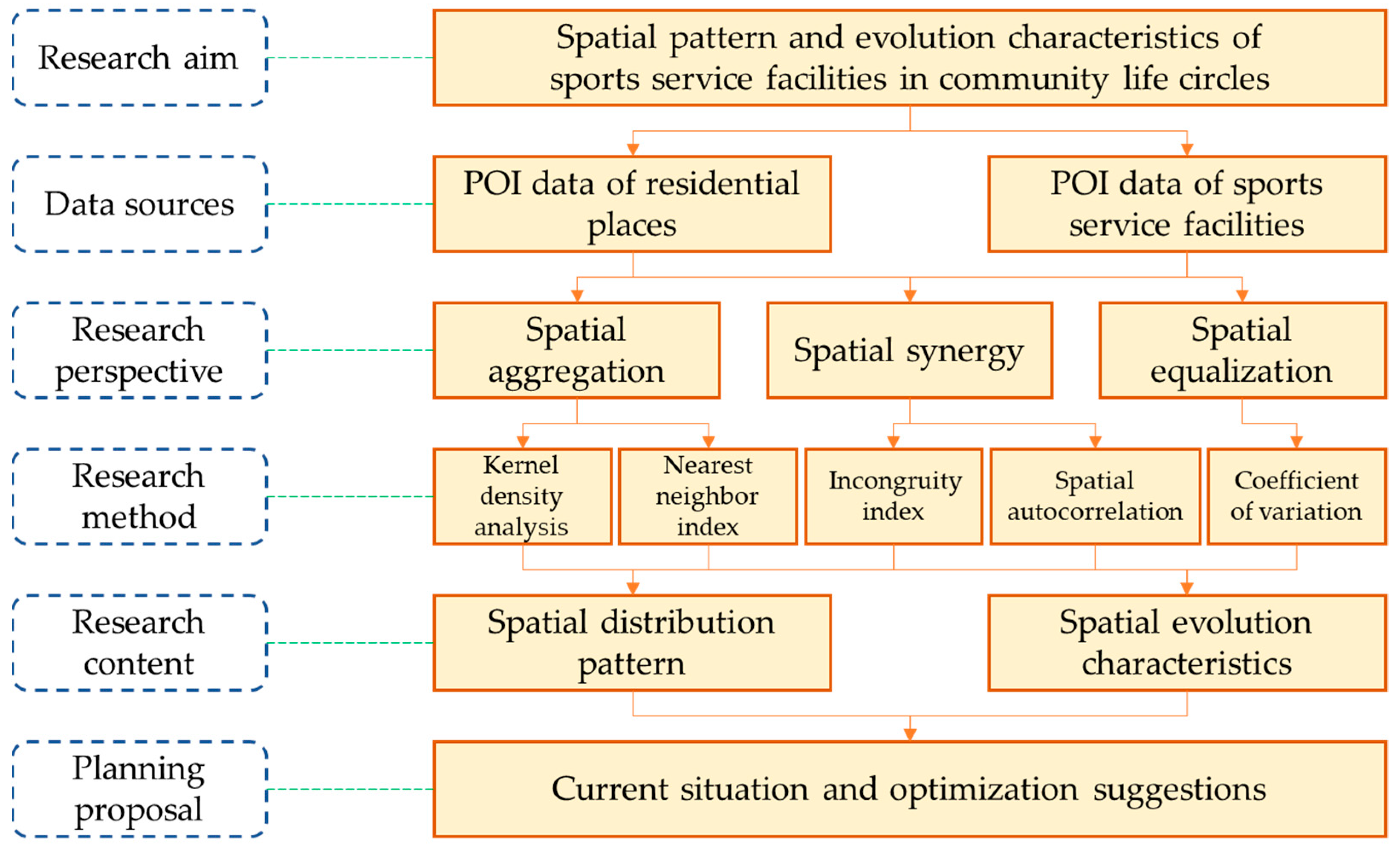
3. Research Data and Methods

3.1. Research Area

The Yangtze River Delta (YRD) urban agglomeration, situated in the downstream region of the Yangtze River and adjacent to the Yellow Sea and the East China Sea, is formed by the alluvial plain where the Yangtze River flows into the sea. As one of China’s fastest-growing economic regions, the YRD urban agglomeration has undergone multiple expansions and now encompasses Shanghai, the Jiangsu Province, the Zhejiang Province, and the Anhui Province. Having progressed through various stages from initial formation to steady development, the region has made significant advances in economic growth and infrastructure development. The sports industry has emerged as a key driver in the region’s transition from traditional to new growth drivers, with mass sports also experiencing substantial growth in the YRD.
Based on the principles of similar city positioning, development level, development characteristics, and urban rank, this study selects Shanghai City, Nanjing City, Hangzhou City, and Hefei City as the central cities of the YRD urban agglomeration. Shanghai City is a municipality directly under the central government, while Nanjing City, Hangzhou City, and Hefei City are the provincial capitals of the Jiangsu, Zhejiang, and Anhui provinces, respectively (Figure 1). The combined GDP of these four cities exceeds 9.35 trillion yuan, with a total permanent resident population of 56.2 million, making them representative in regional development. The economic and demographic information of the four cities is shown in Table 1.

3.2. Data Sources

In 1986, the Ministry of Urban and Rural Construction and the National Sports Commission issued the “Interim Provisions on the Quota of Land for Urban Public Sports Facilities”, which defined public sports facility land as areas designated for public access to engage in sports activities, view sports competitions, and train amateur athletes. Openness and public accessibility are fundamental attributes of urban public sports service facilities, and this definition has been widely adopted in related theoretical research and planning practices [44].
The Point of Interest (POI) data consisted of specific point data of spatial entities closely related to daily lives with accurate geographic and attribute information, including longitude, latitude, name, address, type, and label [45,46]. POI data primarily originates from internet maps and other open-source websites related to life services or social activities, offering the advantages of richness and free access [47]. It has been extensively used in research on urban boundary identification, public facility allocation, and commercial space structure. In this study, POI data for Shanghai, Nanjing, Hangzhou, and Hefei for the years 2013 and 2023 were obtained using the location search API service provided by the Amap Open Platform.
Administrative division data were sourced from the visualized shapefiles of administrative divisions available on the Tianditu website. Additional socioeconomic data were retrieved from the statistical yearbooks of the respective provinces and cities or from various government work websites. Basic information on all the kinds of research data gathered is shown in Table 2.

3.3. Research Methods

Based on POI data representing various types of sports service facilities within community life circles, this study analyzes the spatial patterns and evolutionary characteristics of these facilities in the central community life circles of the Yangtze River Delta (YRD). The analysis is conducted from the perspectives of spatial aggregation, coordination, and equalization. Methods employed include kernel density analysis, the nearest neighbor index, spatial autocorrelation, and coefficient of variation. These techniques are used to investigate the spatial patterns and evolutionary trends of sports service facilities, identify existing issues, and propose optimization measures. The technical route is shown in Figure 2.

3.3.1. Delimitation of Community Life Circles

According to the “Technical Guidelines for Community Life Circle Planning,” a community life circle is defined as a fundamental unit that addresses various needs of urban and rural residents throughout their life cycle within a convenient daily walking distance. The “Standards for Urban Residential Area Planning and Design” specify that the standard walking distance for a 15-min life circle ranges between 800 and 1000 m. Considering the needs of special groups such as the elderly and children, this study adopts a maximum limit of 1000 m as the standard distance for defining community life circles.
Euclidean distance represents the geometric distance from the center of a grid unit to the nearest source object. In Euclidean allocation, grid units are assigned to source objects based on this distance, with each grid unit being allocated to the nearest source object. In this study, residential POI data are used as source objects according to the principle of Euclidean allocation. Grid units are delineated into community life circle grids with a scale of 1000 m by 1000 m based on the standard distance. This approach ensures that only spatial areas with residential facilities are analyzed within community life circles and allows for equal-scale comparison and analysis of subsequent research results. Residential POI data are distributed into 1000 m × 1000 m grid units, defining all community life circle grids accordingly.

3.3.2. Classification System for Sports Service Facilities

The classification system for sports service facilities within community life circles is designed to address both basic public service needs and the requirements of community life circle construction. This system is aligned with the goals outlined in the “14 th Five-Year Plan for Public Services,” which focuses on safeguarding targets and addressing existing gaps to define specific demand categories. Building on this foundation, the “Technical Guidelines for Community Life Circle Planning” provide basic requirements for the allocation of essential public service facilities, viewed from a service element allocation perspective.
The “Technical Guidelines for Community Life Circle Planning” specify the types of sports service facilities that need to be constructed to meet the fitness needs of residents within the community life circle. The POI data used in this study, sourced from the Amap open platform, is similarly categorized into primary, secondary, and tertiary classes. However, there are differences in the POI classification systems between 2013 and 2023. To accurately reflect the spatio-temporal evolution of sports service facilities using POI data, it is necessary to establish a mapping relationship between the types of sports service facilities and the POI categories. In Table 3, the first and second columns represent the types of sports service facilities specified in the Technical Guidelines for Community Life Circle Planning; the third, fourth, and fifth columns correspond to the types of Amap POI data in 2013 that match the sports service facility types; the sixth, seventh, and eighth columns correspond to the types of Amap POI data in 2023 that match the sports service facility types. By spatially linking the community life circle grid with the sports service facilities POI data, the sports service facilities in the community life circle are ultimately obtained (Figure 3, Figure 4, Figure 5, Figure 6, Figure 7, Figure 8, Figure 9 and Figure 10).

3.3.3. Spatial Allocation Evaluation Indicators

Spatial aggregation, spatial synergy, and spatial equalization are three important dimensions for describing the spatial distribution characteristics of a given object, providing a comprehensive view of its spatial patterns. Therefore, this paper develops a method for extracting the spatial distribution characteristics of urban sports facilities based on these three aspects, incorporating spatial analysis metrics such as the aggregation index, synergy index, and equalization index. Specifically, the aggregation index measures the degree of spatial clustering of sports service facilities, reflecting whether their distribution is overly dispersed or concentrated; the synergy index assesses the spatial similarity or correlation between sports service facilities and community life circles; and the equalization index evaluates the alignment between the supply capacity of sports service facilities and the demand within community life circles, aiming to prevent excessive concentration or an insufficiency of facilities.
(1)
Aggregation Characteristics
Kernel density estimation (KDE) and the nearest neighbor index (NNI) are both effective in analyzing whether point data exhibits clustering. KDE is suitable for studies that require detailed insights into local density variations in space, making it ideal for identifying specific areas of concentration or sparsity. On the other hand, NNI is more appropriate for quantitatively describing overall distribution patterns but does not reveal specific local density variations. In this paper, both types of metrics are applied in tandem to analyze aggregation characteristics.
KDE is widely used to characterize the relative concentration of point features in spatial distributions. It is a non-parametric method that does not assume a specific data distribution but instead directly examines the spatial distribution characteristics from the data sample [59]. KDE calculates the density of point features by moving a fixed-size window (grid) across the study area, computing density estimates for each grid cell in the output. The formula for calculation is:
f ( x , y ) = 1 n h 2 i = 1 n K ( x x i h x , y y i h y )
In the Formula (1), f(x, y) represents the kernel density estimate at spatial coordinates (x, y); n is the number of sports service facilities in the community life circle; h is the distance decay threshold; and K is the kernel function.
NNI is used to characterize the spatial distribution pattern of point features. It evaluates whether the average observed distance between neighboring points differs from the expected distance under a random distribution [60]. This index classifies distributions into three types: clustered, uniform, and random. The formula for calculation is:
NNI s = d ¯ d e
d e = 1 2 n / π
In the Formulas (2) and (3), NNIs represents the nearest neighbor index of sports service facilities within community life circles;   d ¯ denotes the average observed distance between nearest neighbor pairs of these facilities, while de signifies the expected average distance under random distribution of these facilities; and n stands for the number of sports service facilities within community life circles. When R > 1, the distribution of sports service facilities within community life circles is uniform, and this indicates a uniform type. When R = 1, it is random. When R < 1, it is clustered; indicating an aggregation tendency of sports service facilities within community life circles.
(2)
Synergy Characteristics
The matching synergy index and spatial correlation analysis are both tools used to assess the correlation or degree of matching between spatial data, revealing whether consistency exists in spatial patterns. The matching synergy index is well-suited for analyzing dual phenomena, enabling the assessment of the coordination between sports service facilities and community life circles. In contrast, spatial correlation analysis is ideal for evaluating the spatial distribution patterns of a single phenomenon, making it useful for detecting internal distribution patterns within sports service facilities.
The incongruity index is a statistical measure that reflects the degree of inconsistency between two sets of data. It is widely used in studies of spatial clustering or spatial matching levels in populations, economies, and industries [61]. Based on a well-established formula for incongruity index, we can derive the spatial matching synergy index (Ci) between sports facilities and community life circles. This index can reflect the degree of spatial matching and balance between sports facilities and community life circles. The formula for Ci is:
C i = S i / S q U i / U q
In the Formula (3), Si represents the total number of sports service facilities in region i; Sq represents the total number of sports services facilities in study area q; Ui represents the total number of community life circles in region i; and Uq represents the total number of community life circles in study area q. If Ci < 1, it indicates that region i belongs to the lagging type in terms of the matching coordination with community life circle and sports service facilities. If Ci > 1, it indicates that region i belongs to the advanced type in terms of the matching coordination with community life circle and sports service facilities. If Ci = 1, it indicates that region i belongs to the consistent type.
Spatial correlation analysis includes two main methods: global and local spatial autocorrelation analysis. The global spatial autocorrelation analysis primarily employs two index methods: (1) Moran’s index (Moran’s I, IM), which ranges from [–1, 1]. IM > 0 indicates a clustering trend, showing spatial positive correlation; IM < 0 indicates a dispersing trend, showing spatial negative correlation; and IM = 0 indicates spatial randomness [62]. The formula for IM is:
I M = N i = 1 n j = 1 n w i j ( x i x ¯ ) ( x j x ¯ ) S 0 i = 1 n ( x i x ¯ ) 2
In the Formula (5), IM represents Moran’s index; n represents the total number of the grid units of community life circles; i and j represent the indices of the grid units of community life circles; x ¯ represents the mean of sports service facilities per grid unit; wij represents the spatial weight matrix, indicating the spatial relationship between grid unit i and grid unit j; and S0 represents the sum of the elements in the spatial weight matrix.
(2) Getis-Ord General G Index method, which ranges from [0, 1]. The null hypothesis of the Getis-Ord General G statistic states that there is no spatial clustering of feature values. If the returned p-value is small and statistically significant, the null hypothesis can be rejected. If the null hypothesis is rejected and the z-score is positive, it indicates that high values are clustered in the study area; if the z-score is negative, it indicates that low values are clustered in the study area [63]. The formula for G is:
G = i = 1 n j = 1 n w i j x i x j i = 1 n i = 1 n x i x j
In the Formula (6), G represents the Getis-Ord General G Index; n represents the total number of the grid units of community life circles; i and j represent the indices of the grid units of community life circles; and wij represents the spatial weight matrix, indicating the spatial relationship between grid unit i and grid unit j.
Local spatial autocorrelation analysis primarily uses the Anselin Local Moran’s I Index, with results presented in four forms: (1) High–High clusters (H–H); (2) Low–High outliers (L–H), where low values are surrounded by high values; (3) Low–Low clusters (L–L); (4) High–Low outliers (H–L), where high values are surrounded by low values [64]. The formula for Ii is:
I i = ( x i x ¯ ) · j = 1 n w i j ( x j x ¯ ) S 2
S 2 = 1 n i = 1 n ( x i x ¯ ) 2
In the Formulas (7) and (8), Ii represents the Anselin Local Moran’s I index; n represents the total number of the grid units of community life circles; i and j represent the indices of the grid units of community life circles; x ¯ represents the mean of sports service facilities per grid unit; wij represents the spatial relationship between grid unit i and grid unit j; and S2 represents the variance of the sample data.
(3)
Equalization Characteristics
In statistics, common methods for measuring equalization levels include the coefficient of variation (CV), the Gini coefficient, and the Theil index. The coefficient of variation, also known as the relative standard deviation, primarily examines the ratio between the standard deviation and the mean. It reflects the degree of disparity or dispersion among the values within a dataset. The coefficient of variation measurement method is widely used in the study of the equalization of basic public service facilities [65]. A larger CV indicates greater disparity in service facility equalization, while a smaller CV suggests a higher degree of equalization. In this study, we calculate the coefficient of variation (CV) for the sports service facilities within community life circles in the research area. The calculation formula is as follows:
C i = S i / S q U i / U q
In the Formula (9), yj represents the total distribution of sports service facilities in the j-th community life circle of a certain region, where j = 1, 2, 3, …, n; and u represents the average value of all sports service facilities in the community life circle.

4. Results and Analysis

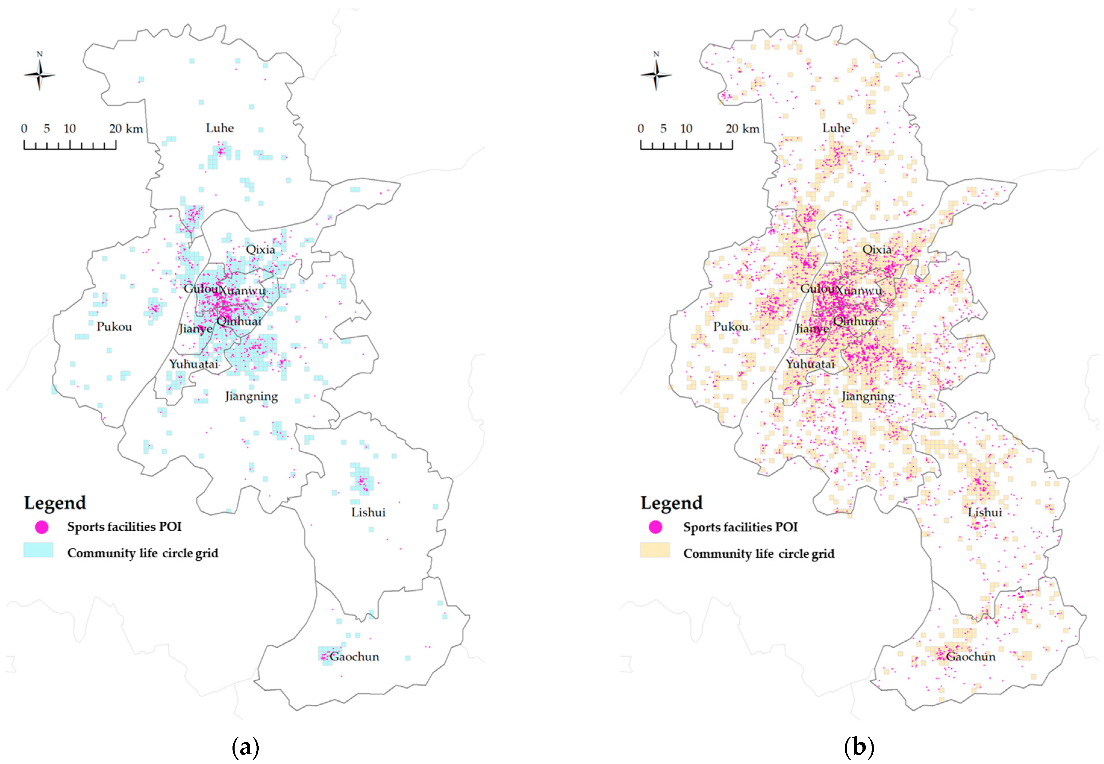
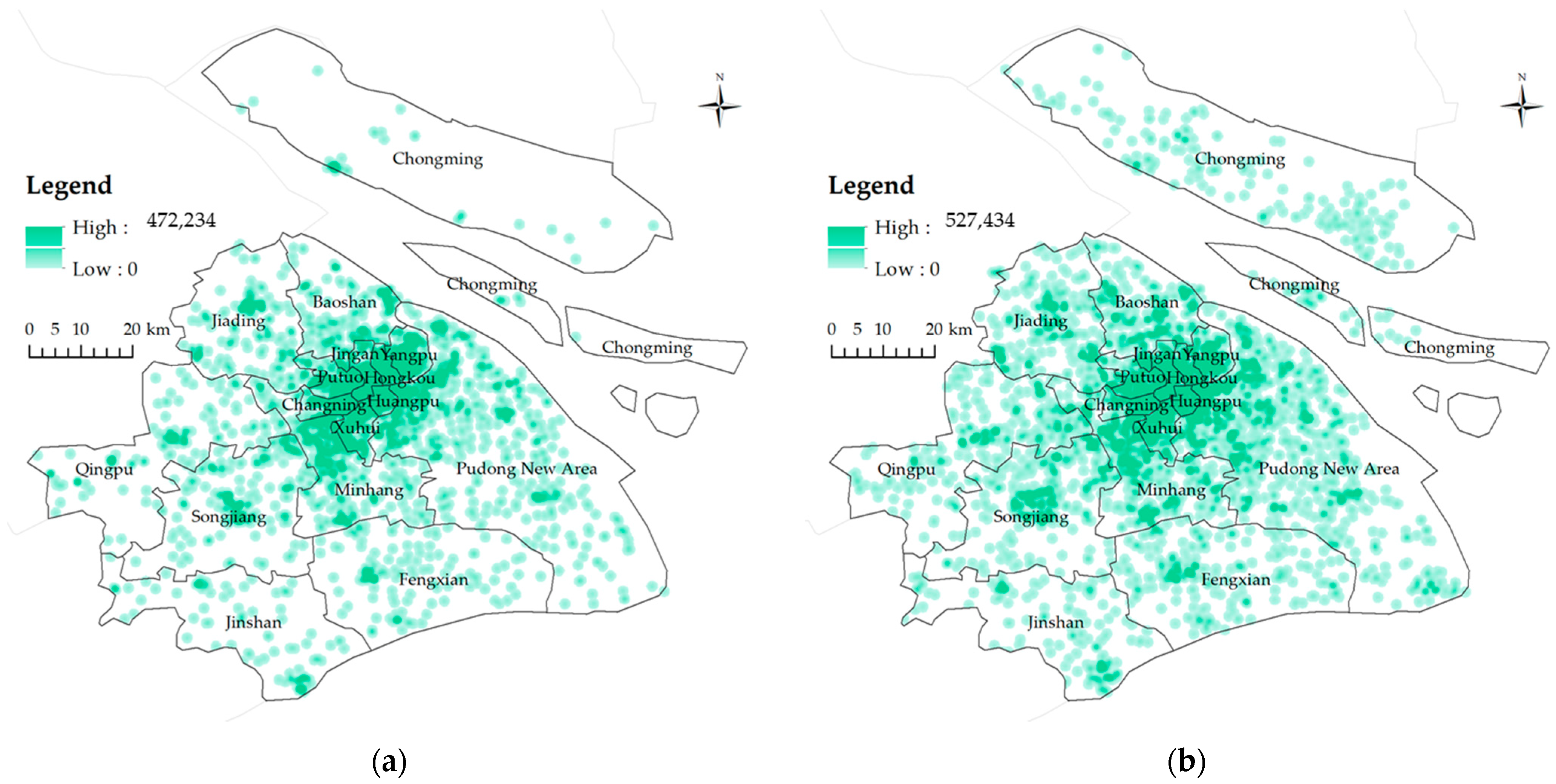
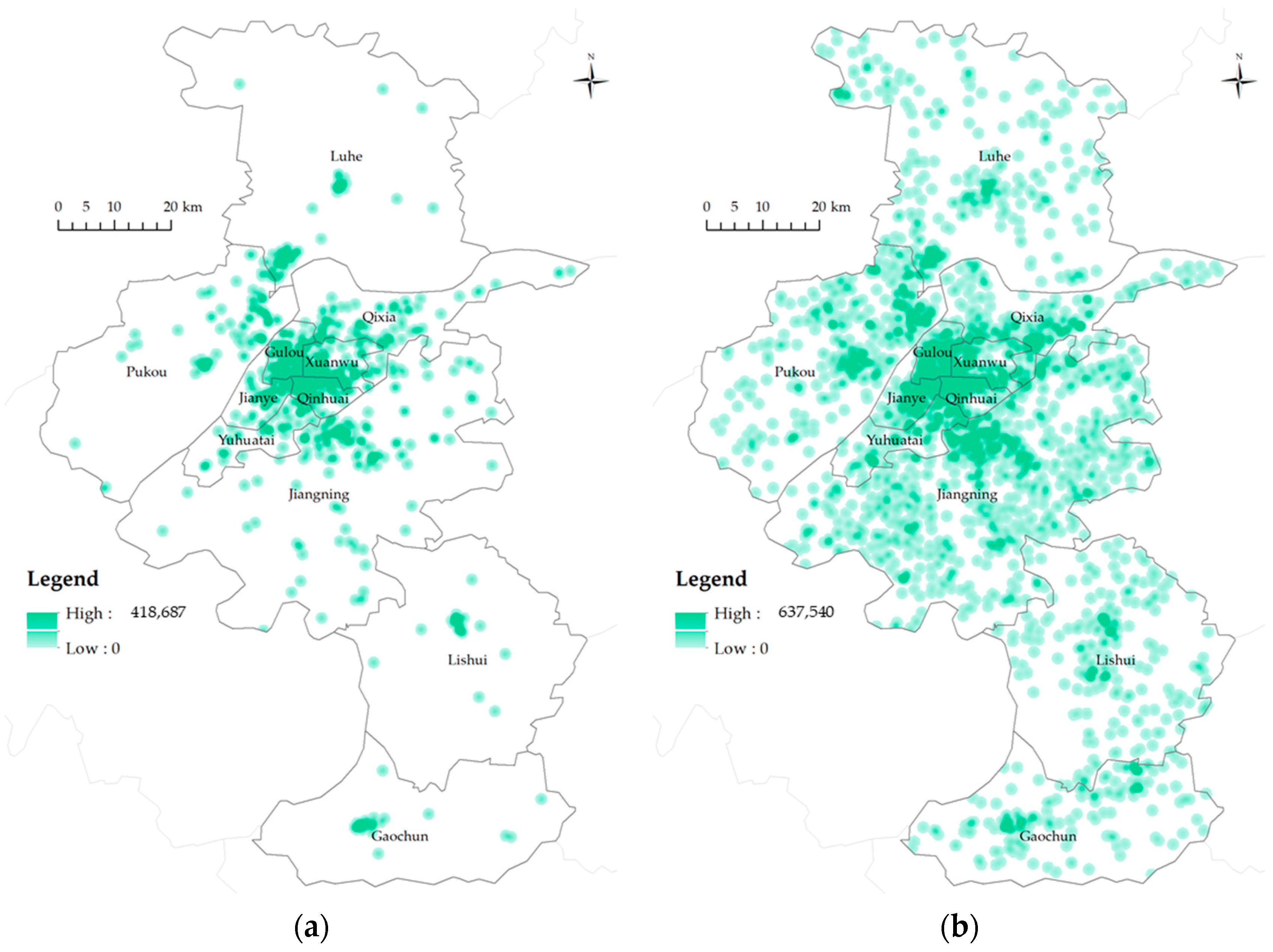
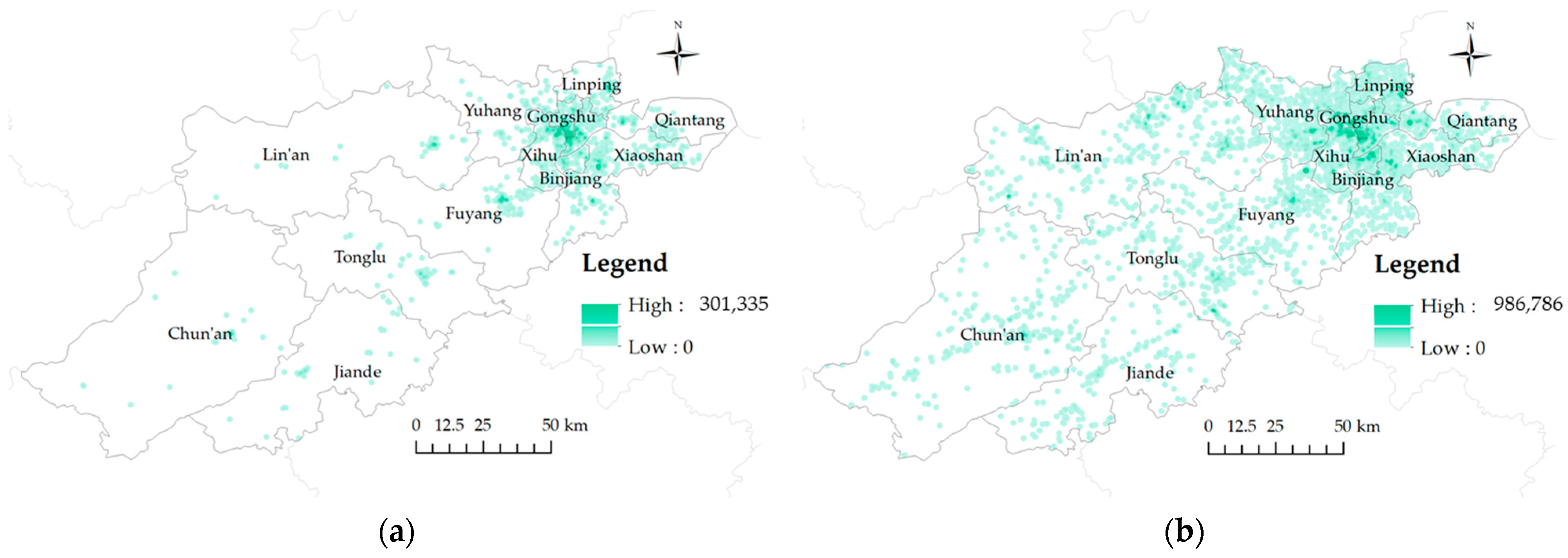
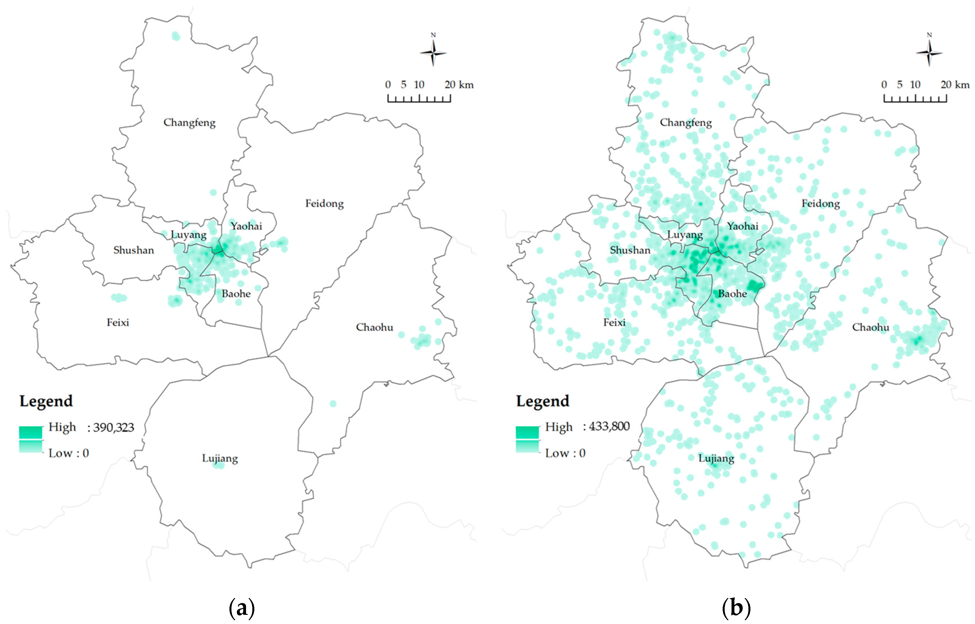
4.1. Aggregation Characteristics Analysis

The nearest neighbor index of sports service facilities in 2013 were 0.3634 for Shanghai City, 0.2948 for Nanjing City, 0.2946 for Hangzhou City, and 0.1843 for Hefei City. In 2023, these values changed to 0.3589 for Shanghai City, 0.4048 for Nanjing City, 0.3514 for Hangzhou City, and 0.3859 for Hefei City. All nearest neighbor indices were less than 1 and passed a significance level test with p-value < 0.01 (Table 4). The results indicate that the spatial distribution of community life circle sports facilities in the study area is clustered, demonstrating significant spatial aggregation characteristics. Analyzing the nearest neighbor index for each city from 2013 to 2023 reveals that Shanghai experienced a slight increase in the clustering of public sports facilities, while the other cities showed a decreasing trend. Hangzhou currently exhibits the highest level of clustering among the cities studied. Nanjing City shows weaker spatial clustering of public sports facilities compared to Shanghai and Hangzhou. Hefei City had the highest level of clustering in 2013 but has shown the most significant change in clustering intensity in recent years.
Conducting kernel density estimation and spatial visualization of sports service facilities in community life circle to further clarify spatial aggregation patterns and distribution characteristics: (1) Shanghai City. The spatial aggregation pattern of sports service facilities in Shanghai City exhibits a single-center circular structure, with the central urban area as the core radiating throughout the entire city and beyond (Figure 11). In several suburban areas designated as secondary centers, localized high-aggregation features are also evident. From 2013 to 2023, the central urban area consistently maintained a high level of aggregation, while the scope of aggregation in suburban secondary centers expanded relatively. Chongming District, however, did not show significant aggregation patterns.
(2) Nanjing City. The spatial pattern of sports service facilities in Nanjing City exhibits a multi-center contiguous aggregation (Figure 12). The aggregation centers are primarily located within the central urban area, exhibiting significant aggregation trends with high concentration levels. In 2013, Gulou District, Xuanwu District, Jianye District, and Qinhuai District demonstrated notable aggregation characteristics for community life circle sports facilities, each with a single aggregation center and a relatively small radiating range. By 2023, areas adjacent to the central urban area, such as the Qixia District, the Yuhuatai District, the Jiangning District, and the Pukou District, also developed distinct aggregation centers. The Jiangning District and the Pukou District displayed dispersed features over larger areas.
(3) Hangzhou City. The spatial pattern of sports service facilities in Hangzhou City exhibits a mixed aggregation characteristic of surface aggregation and multi-point dispersion (Figure 13). In 2013, the primary pattern was surface aggregation concentrated mainly in the central urban area, while other districts and counties exhibited scattered distributions with single aggregation centers. By 2023, community life circle sports facilities in the central urban area had formed contiguous aggregations, with multi-point dispersion features also emerging in the surrounding areas. Overall, the distribution of sports service facilities in Hangzhou is relatively balanced, effectively meeting the fitness needs of residents.
(4) Hefei City. The spatial pattern of sports service facilities in Hefei City also exhibits a single-center ring structure (Figure 14). In 2013, most sports service facilities were clustered around the central urban area, with districts such as Feixi County, Feidong County, Lujiang County, Chaohu City, and Changfeng County having relatively few facilities and lacking significant clustering centers. By 2023, the clustering effect in the central urban area had significantly intensified, with multiple clustering centers emerging in the Baohe District and the Shushan District. However, changes in the surrounding counties were relatively slow, with most having only small clustering centers. Feixi County, Feidong County, and Changfeng County still lacked significant clustering centers. These observations align with the results of the nearest neighbor index, reinforcing the findings on the spatial distribution characteristics of sports service facilities.

4.2. Synergy Characteristics Analysis
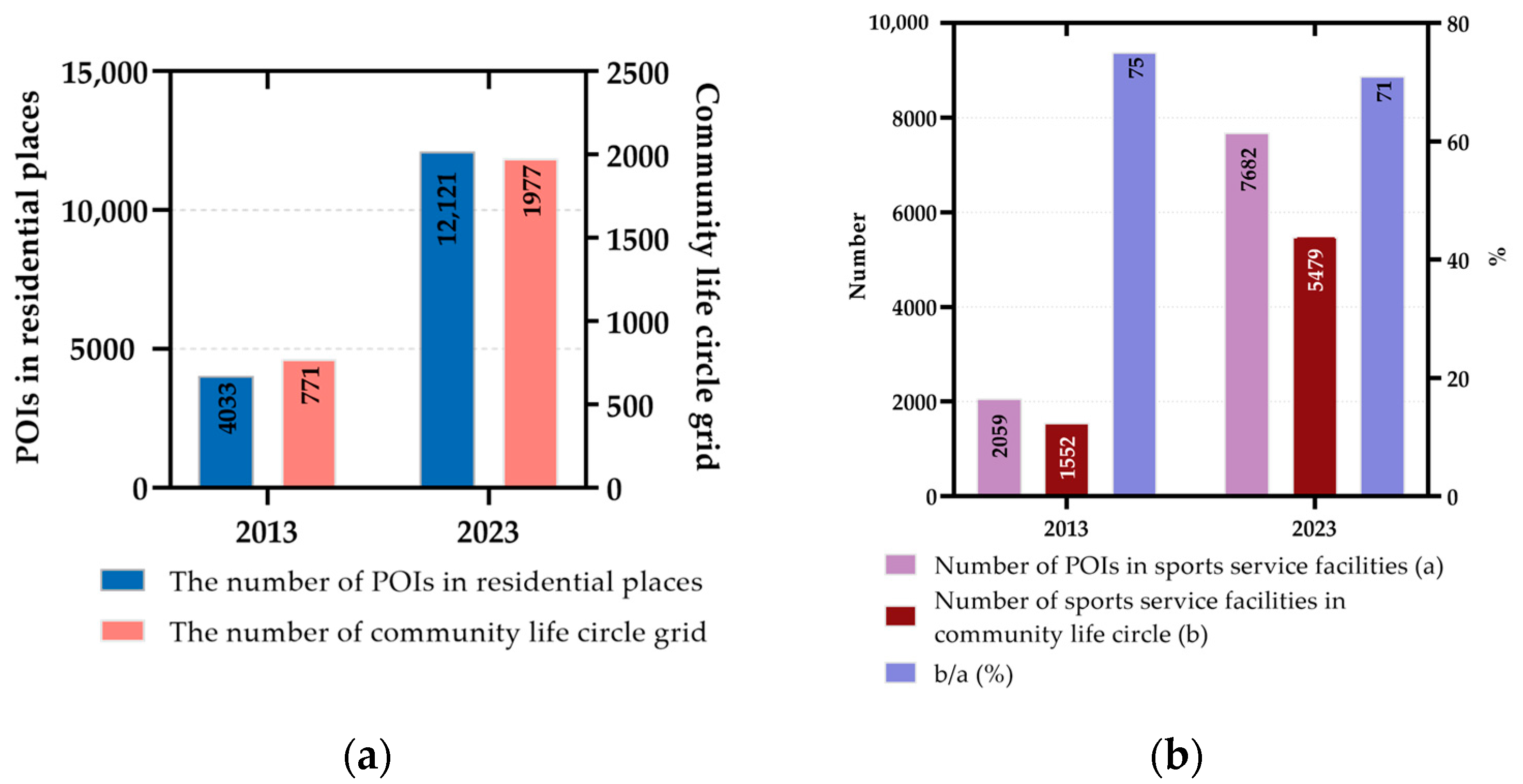
The matching synergy index of sports service facilities in each city of the study area is shown in Table 5. In both 2013 and 2023, two types of spatial matching synergy were observed:
(1)
In 2013: Only Shanghai City had a synergy index greater than 1, indicating a proactive matching synergy. The number of sports facilities in Shanghai City exceeded the combined total of Nanjing City, Hangzhou City, and Hefei City, suggesting that Shanghai’s overall provision of sports facilities surpassed the requirements of its community life circles. This indicates that Shanghai City’s allocation of sports service facilities more effectively supports and serves its community life circles. In contrast, Nanjing City, Hangzhou City, and Hefei City all had synergy indices less than 1, indicating a lagging synergy. Hefei City had the lowest synergy index at 0.81, reflecting inadequate matching.
(2)
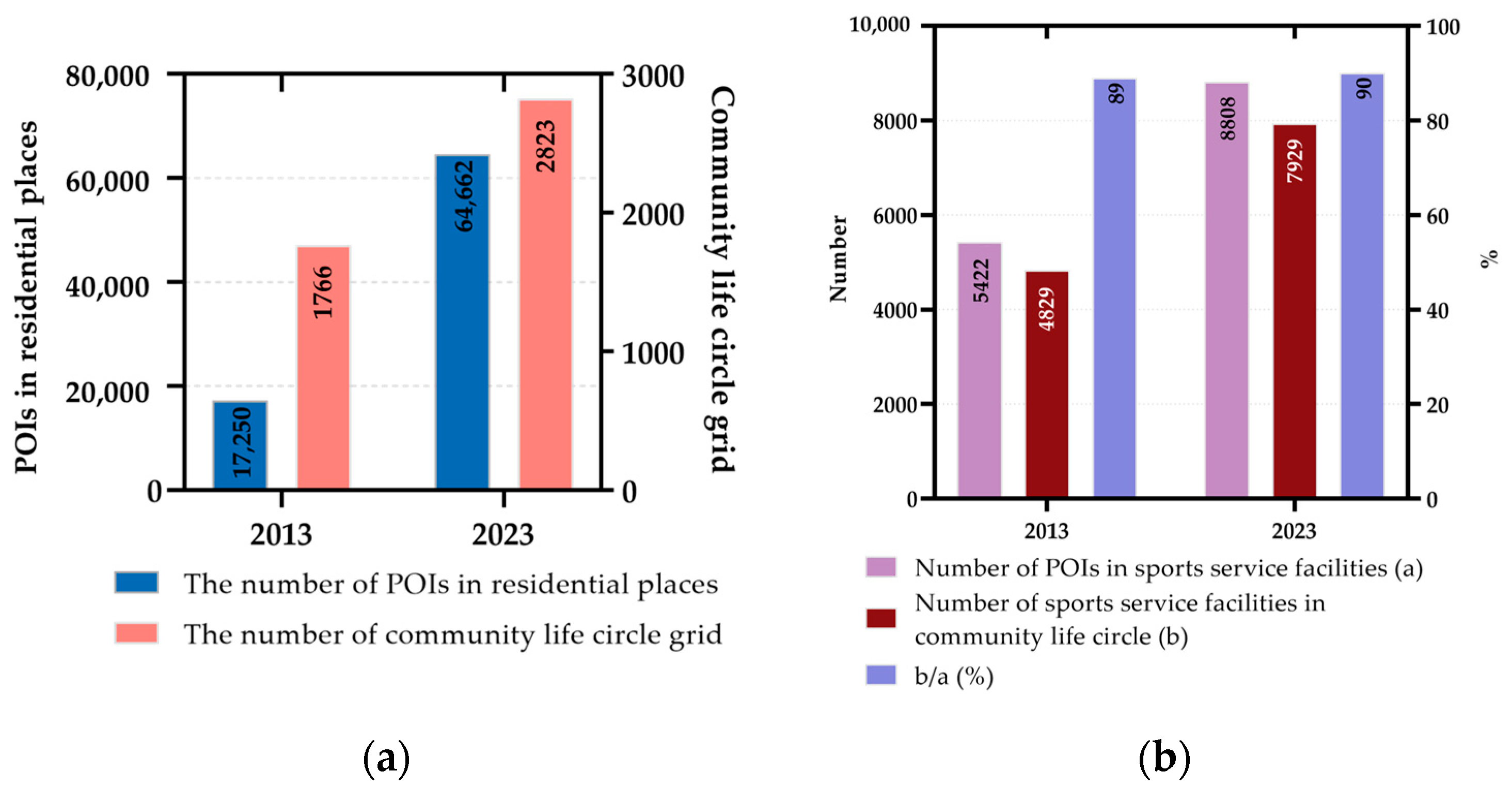
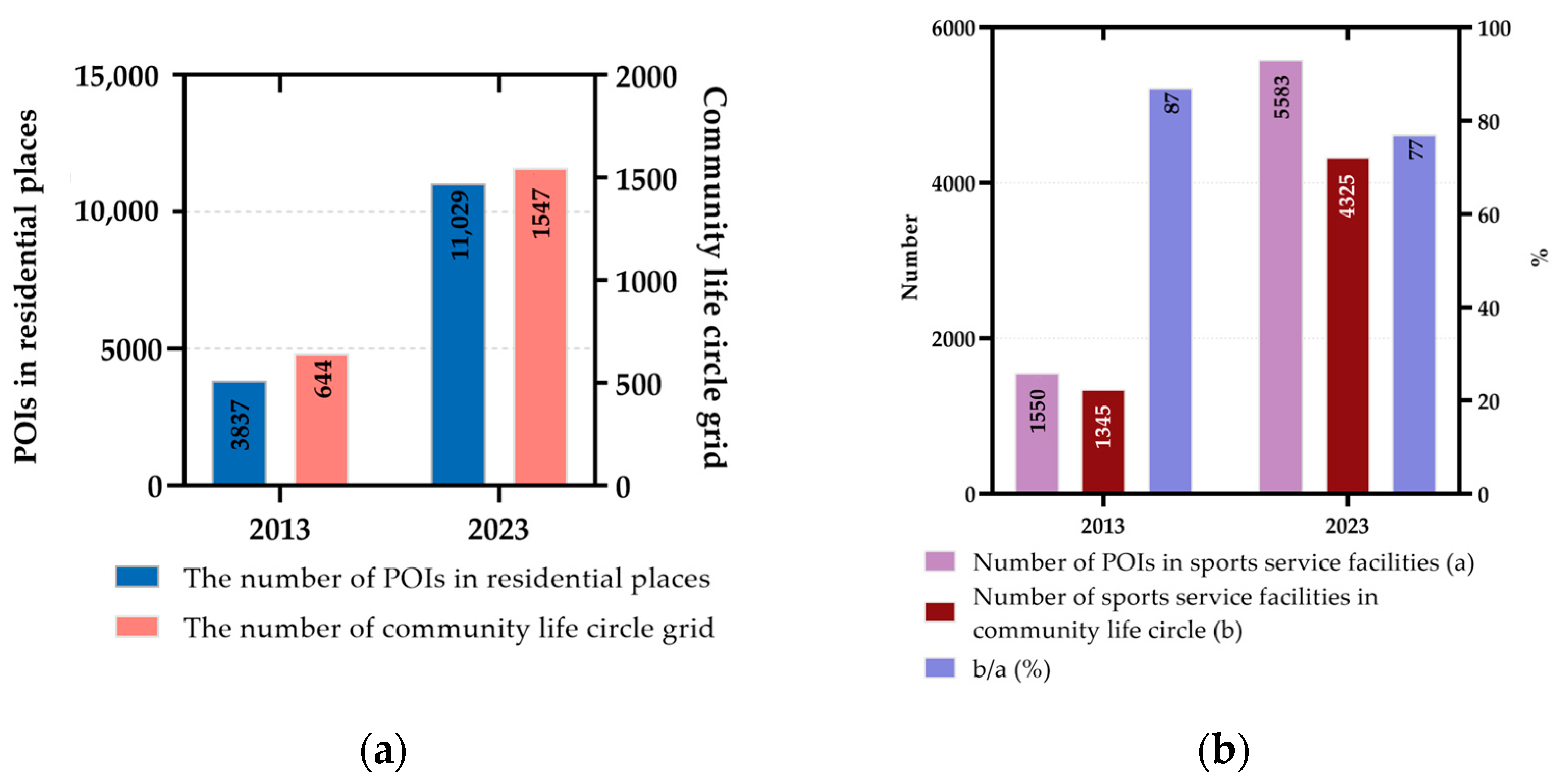
In 2023: Shanghai City, Nanjing City, and Hangzhou City all had synergy indices greater than 1. Nanjing City and Hangzhou City experienced rapid increases in the number of sports service facilities, with Hangzhou City adding 2980 facilities—the largest increase among the study areas. This development improved the synergy indices for both Nanjing City and Hangzhou City from lagging to synergistic. Shanghai City’s rate of sports service facility development was slower compared to Nanjing City and Hangzhou City, resulting in a slight decrease in its synergy index from 2013 but still within the synergistic range. Hefei City saw a 2.65% growth in the number of sports facilities from 2013 to 2023, the highest growth rate among the study areas. However, due to its relatively weak initial infrastructure, Hefei City’s synergy index remained lagging, positioning it as weaker within the study area.
The global spatial autocorrelation indicators for community life circle sports facilities in the four cities are shown in Table 6. Both methods’ p-values are less than 0.01, and the Z-values exceed 2.58, indicating statistical significance at a 99% confidence level through significance testing. Comparative analysis of Moran’s I (IM) reveals the following insights: (1) IM values are uniformly distributed in the range of (0.4, 0.6), all greater than 0. This indicates that the spatial allocation of community life circle sports facilities in the study area’s four cities exhibits a clustering trend, showing a positive spatial autocorrelation relationship. (2) IM values of Shanghai City, Hangzhou City, and Hefei City show a declining trend from 2013 to 2023. The spatial clustering significance of community life circle sports facilities in these cities has relatively weakened. This suggests a rapid development of sports facilities in peripheral areas outside the central urban districts, transitioning from core high-value clustering to gradually dispersed distributions, forming one or multiple core high-value clustering areas. (3) IM values of Nanjing City show an increasing trend from 2013 to 2023. The spatial clustering significance of community life circle sports facilities has significantly strengthened, particularly in 2023, where Nanjing City’s IM is the highest among the study areas. This indicates a more significant development of sports facilities in the central urban districts of Nanjing, forming multiple clusters in high-density aggregation states. Overall, the spatial autocorrelation characteristics of sports facilities in the study area are coupled with the spatial clustering patterns identified in the aggregation analysis.
By comparing GO and GE, the following can be observed: (1) In all research areas, GO > GE, indicating that the overall distribution of community life circle sports service facilities shows a high-value clustering trend, with a high-level aggregation of sports service facilities. (2) By comparing the differences between GO and GE values, it is evident that the clustering of high-value areas within each research area is notably prominent, forming hotspots in the allocation of community life circle sports service facilities within the coordinated areas. Since global spatial autocorrelation can only reflect the overall spatial characteristics of a region and cannot effectively determine the spatial relationships and features within the region, it is necessary to employ local spatial autocorrelation analysis methods for further analysis.
Due to the fragmented spatial distribution of community life circles within urban areas, this study employed a distance-based spatial weight matrix for local spatial autocorrelation analysis. In 2013, a total of 1652 community life circle grids in the four cities passed the significance test, which increased to 2945 grids by 2016. Among all grids that passed the significance test, only three types of local spatial relationships were observed: H–H, L–H, and H–L. The L–L type of local spatial relationship was not present. The following observations were made based on a comprehensive comparison: (1) H–H Type: High-value areas with significant concentrations of sports service facilities are distributed in contiguous patches, making them the most predominant form of local clustering. (2) H–L Type: High-value areas surrounded by low-value areas are relatively rare. These community life circles, which have high levels of sports service facilities within themselves but low levels in surrounding areas, are generally uncommon. (3) L–H Type: Low-value areas surrounded by high-value areas are more common across various regions. These community life circles, characterized by low levels of sports service facilities within themselves but higher levels in surrounding areas, present opportunities for targeted improvement.
The spatial distribution characteristics of each clustering type are as follows: (1) H–H Type: Primarily located in the central areas of cities, these clusters feature higher levels of community life circle sports service facilities. Their contiguous distribution confirms the positive spatial relationships indicated by global spatial autocorrelation, reflecting spatial differentiation in the development levels of sports service facilities among different regions. (2) L–H Type: Surrounding H–H type areas, these clusters exhibit lower levels of sports service facilities within themselves, indicating overall development imbalances. (3) H–L Type: Although relatively rare in 2013, these clusters significantly increased by 2023, mainly in secondary city centers. They have a localized driving effect on the overall improvement of community life circle sports service facilities.
In 2013, as shown in Figure 15: (1) Shanghai City has the highest proportion of H–H type high-value clusters, reaching 39.24%, significantly higher than Hangzhou City, Nanjing City, and Hefei City. This indicates that the level of sports service facilities within community life circles in Shanghai City is superior. (2) H–L Type, where high values are surrounded by low values, are relatively rare across the four cities. Shanghai accounts for 76% of this type in the entire study area, playing a significant role in driving and radiating benefits to the surrounding areas. (3) L–H Type, where low values are surrounded by high values, are more prevalent in Shanghai City and Hangzhou City compared to Nanjing City and Hefei City. This “depression” in the allocation level should be actively addressed and improved.
In 2023, as shown in Figure 16: (1) Hangzhou City has the highest proportion of H–H type high-value clusters, reaching 35.07%. This reflects two key aspects: first, it highlights the strong service capacity of sports service facilities within community life circles in Hangzhou City, with high-value areas developing more rapidly than in the other cities; second, it indicates an overall improvement in the allocation level of sports service facilities across the study area, resulting in a more balanced distribution of high-value areas among the cities. (2) H–L Type, where high values are surrounded by low values, remain relatively rare across the four cities. This suggests that extreme imbalances, where high-value sports service facilities are isolated from their surroundings, are uncommon. (3) L–H Type, where low values are surrounded by high values, show that Nanjing City has the lowest proportion at 17.38%. This anomaly might occur in areas where surrounding sports service facilities are generally abundant. It also indicates that Nanjing City prioritizes the enhancement of existing high-value clusters over the expansion of new high-value areas.
Overall, from 2013 to 2023, the development level of sports service facilities in Shanghai City has consistently led the way and shown steady improvement. Hangzhou City and Nanjing City have made significant advancements, with Hangzhou City developing at a faster pace, bringing some indicators close to or exceeding those of Shanghai City. Nanjing City has excelled in achieving balanced urban development. Hefei City has experienced the fastest growth; however, due to initial disadvantages in overall quantity and distribution, its current development level still lags behind that of the other three cities.

4.3. Equalization Characteristics Analysis

The larger the coefficient of variation (CV) for sports service facilities within community life circles, the lower the degree of equalization. Based on the ranking from the smallest to largest CV, indicating high to low levels of equalization, the order is as follows (Table 7): (1) In 2013, the ranking of cities in terms of sports service facility development was as follows: Hangzhou City > Shanghai City > Hefei City > Nanjing City. Shanghai City, Nanjing City, and Hefei City were all below the average level. (2) In 2023, the ranking shifted to: Hangzhou City > Nanjing City > Hefei City > Shanghai City. Shanghai City and Hefei City were below the average level. The degree of equalization among the four cities has decreased, and by 2023, the coefficient of variation (CV) values converged. This trend indicates that disparities in the allocation of sports service facilities have widened over time. While some community life circles now offer high-quality sports spaces, such as upscale gyms and sports complexes, others still lack basic public sports facilities. The availability of amenities like sports parks and fitness trails is gradually diminishing.

5. Discussion

5.1. Current Situation

This study examines the spatial patterns and evolutionary characteristics of sports service facilities within community life circles across Shanghai City, Nanjing City, Hangzhou City, and Hefei City in the Yangtze River Delta (YRD) region. The research reveals significant differences in the spatial distribution and characteristics of these facilities across the cities. Shanghai City has consistently maintained a high level of service for its community life circle sports facilities. Hangzhou City and Nanjing City have demonstrated continuous growth, with Hangzhou City focusing on expanding its spatial coverage and Nanjing City on increasing the density of existing facilities. Hefei City, while starting with a weaker foundation in sports service facilities, has exhibited the fastest growth rate, indicating substantial potential for improvement. Overall, it can be concluded that the four cities are at varying stages of development regarding their sports service facilities. Notably, there are some shortcomings in the spatial allocation of these facilities, primarily reflected in the following aspects:
(1)
“Quantity–Scale” imbalance. There is a notable imbalance in the development of urban sports spaces across different regions. In 2013, Shanghai City had 4055 more community life circle sports facilities than Hefei City. By 2023, this gap had widened to 5097 facilities, with Shanghai City having 2.8 times the number of facilities compared to Hefei City. Despite Shanghai City’s smaller total area (6300 square kilometers) compared to Hefei City (11,400 square kilometers) and its larger permanent population (24.87 million in Shanghai City versus 9.85 million in Hefei City), the disparity in sports facility construction remains pronounced.
(2)
“Core–Periphery” characteristics. The fragmentation of urban sports space layouts within the same regional scope is pronounced. Sports facilities in each city are typically arranged in a free layout, resulting in a fragmented distribution of urban sports spaces. This fragmentation leads to a concentration of most sports facilities in central urban areas, while peripheral urban zones experience an insufficient supply of sports spaces. This imbalance results in uneven coverage and a lack of resource integration. Empirical results indicate that cities within the study area have not yet achieved comprehensive coverage of the “15-min fitness circle” in their communities, revealing a gap between the current state and the goal of “fitness everywhere”.
(3)
“High value–Low value” disparity. As a core component of public services, urban sports spaces are intended to be accessible to all residents. However, the commodification of these spaces can undermine this principle, turning the equitable function of urban sports spaces into a privilege enjoyed by a few and infringing on the sports rights of disadvantaged groups. In some cities, a “fill-in-the-gaps” approach is used in constructing urban sports spaces, often locating facilities in remote areas. This approach leads to poor spatial accessibility and insufficient integration with the surrounding environment.
(4)
“Venue–Residential” overlap. Analysis of POI data reveals that 70%−90% of sports service facilities in each city are situated within community life circles. The densely distributed sports facilities in central urban areas coincide with regions of high residential density. However, this concentration does not necessarily equate to an abundance of sports facility resources. Attention must be given to the service capacity of these facilities, as the high population density in these areas may result in challenges in meeting the needs of all residents.

5.2. Optimization Suggestions

In the planning and design of urban sports spaces, it is essential for government authorities to employ a scientific approach to optimize spatial layouts. The market, a significant contributor to the provision of urban sports spaces, plays a crucial role in offering private sports facilities that complement the public provision. Investment capital, a key driver in the development of these facilities, should balance short-term profitability with adherence to social value principles, thus moderating profit-driven motives. This balanced approach will enhance the living environment for urban residents, fostering a vibrant and dynamic social and economic ecosystem. Effective optimization and improvement in urban sports space provision require collaborative efforts from government agencies, market participants, and the public.
(1)
The government should prioritize a people-centered approach by implementing a differentiated supply strategy to enhance the efficiency of sports space utilization. This involves respecting the organic nature and diversity of the population and addressing the varied sports needs across different age groups. By adopting innovative and differentiated strategies for the provision of sports spaces, the government can enhance the public fitness service system, focusing on the development of urban sports parks, fitness trails, and other public fitness facilities. Additionally, the layout of urban sports spaces should be strategically planned in alignment with the structure of residential areas. It is crucial to continually assess and maximize the potential of existing sports resources, expand the range of sports services, and particularly revitalize large sports venues and public institution facilities, thereby promoting comprehensive access to and utilization of sports spaces.
(2)
Establishing a multi-center, multi-level collaborative governance model is crucial for advancing spatial justice in sports space planning. It is imperative to effectively leverage the market’s role in this process. The government should not only directly provide sports services but also incentivize the involvement of social capital in sports space governance through mechanisms such as public service procurement. Furthermore, the government should offer strategic planning guidance for informal sports spaces, such as street sides, lakesides, and repurposed factories, where residents often engage in leisure and exercise. By optimizing the balance between formal and informal sports spaces, a more diversified supply mechanism can be developed, effectively addressing the challenge of insufficient public space within communities.
(3)
Developers and operators of urban sports spaces must adhere to established construction requirements and standards. They should acknowledge the dual role of capital in commercial development and emphasize its positive contribution to the creation of sports spaces. It is essential to comply with urban facility standards, including per capita green space, the number of fitness facilities, an urban green space area, and standards for squares and parks. Such compliance ensures that green spaces are preserved for residents’ fitness and leisure activities, safeguarding their spatial rights. Additionally, selectively opening community parks and green spaces can mitigate the effects of urban space privatization, fostering a harmonious and inclusive community sports culture.
(4)
Leverage technology to empower residents and enhance their engagement in social governance. Utilize digital innovations, such as Big Data, cloud computing, and the internet to improve sports service facilities, ensuring they cater to users of all ages. This approach will help broaden participation in sports, raise awareness, and promote a culture of universal and lifelong engagement in physical activities. Additionally, as residents become involved in the governance of urban sports spaces, they should clearly communicate their primary needs regarding physical space. Platforms such as WeChat and Weibo can be employed to facilitate this collective expression, providing technical empowerment. This ensures equitable communication and coordination among urban residents, the government, and the market, collectively advancing the development of urban sports spaces.

6. Conclusions

The community life circle functions as a conceptual spatial unit, with its 15-min walking range facilitating accessibility requirements. The fairness in the distribution of sports service facilities within each life circle can be evaluated through comparative validation utilizing data technology. This study focused on central cities in the Yangtze River Delta (YRD) region, delineating small-scale community life circles using kilometer grids based on geographic spatial data from residential Points of Interest (POIs). This methodology ensures both accessibility and comparability. A standardized index system was developed to assess the distribution fairness of sports service facilities within community life circles. Analytical methods, including kernel density estimation, the nearest neighbor index, spatial autocorrelation, and coefficient of variation, were employed to examine the spatial patterns and evolutionary characteristics of sports service facilities in urban life circles across the YRD region, with an emphasis on aggregation, synergy, and equalization.
(1)
The spatial distribution patterns of sports service facilities within the community life circles in the study area consistently demonstrate an aggregated distribution, forming a concentric ring structure from the core to the periphery. However, there are notable differences in the degree of aggregation across different cities, and the core areas of sports service facilities exhibit some spatial heterogeneity. Between 2013 and 2023, the aggregation of sports service facility distribution in Shanghai’s life circles has intensified, whereas a decline in aggregation has been observed in the other cities.
(2)
The synergy of sports service facilities within the community life circles in the study area has seen substantial improvement. In 2013, only Shanghai exhibited a matching synergy between sports service facilities and community life circles. By 2023, Shanghai, Nanjing, and Hangzhou have all achieved this synergy, while Hefei remains in a lagging position. Regarding local spatial autocorrelation characteristics, each city predominantly exhibits high-value clustering, with multiple clusters showing high aggregation and low dispersion, with Hangzhou standing out as particularly notable.
(3)
The level of equalization of sports service facilities within the community life circles of the four cities in the study area is ranked as follows: Shanghai City > Nanjing City > Hangzhou City > Hefei City. Shanghai and Nanjing exhibit relatively small internal spatial differences, suggesting that while their allocation of sports service facilities is not significantly advantageous, weaknesses are not highly pronounced. This indicates a need to address specific shortcomings to strengthen weaker areas. In contrast, Hangzhou and Hefei show more substantial spatial differences, with facility allocation concentrated in areas of absolute advantage and pronounced weaknesses in other regions. This highlights the necessity for focused efforts to promote equity and to narrow the existing gaps.
Based on the identified shortcomings in the spatial patterns and evolution characteristics of sports service facilities within community life circles, this study proposes several improvement measures addressing government, market, and public aspects. Despite employing various methods to analyze the spatial allocation and changes in sports facilities within the Yangtze River Delta (YRD) region, this study has certain limitations. The analysis focused primarily on physical factors such as the number of facilities and spatial layout. Future research could benefit from incorporating additional aspects, such as the diversity of public sports facilities, different scale levels, and the quality of services provided. Furthermore, refining the analysis of population characteristics could enhance the assessment of fairness in public sports facility distribution among various social groups.

Author Contributions

Conceptualization, P.Y.; Data curation, P.Y.; Formal analysis, P.Y.; Investigation, J.W.; Methodology, P.Y.; Project administration, P.Y.; Validation, P.Y.; Visualization, P.Y.; Writing—original draft, P.Y.; Writing—review and editing, P.Y. and J.W. All authors have read and agreed to the published version of the manuscript.

Funding

This research was funded by the National Natural Science Foundation of China (grant no. 42301522), and the Key Project of Social Science Research in Yangzhou City (grant no. 2024YZD-005).

Institutional Review Board Statement

Not applicable.

Informed Consent Statement

Not applicable.

Data Availability Statement

The original data presented in the study are openly available in POI data of sports service facilities at https://gitee.com/yep730/poi-data-of-sports-service-facilities.git (accessed on 20 August 2024).

Conflicts of Interest

The authors declare no conflicts of interest.

References

  1. State Council. Healthy China 2030 Planning Outline. Available online: http://www.gov.cn/zhengce/2016-10/25/content_5124174.htm (accessed on 10 July 2024).
  2. State Council. The State Council Issued a Circular on the National Fitness Program (2021–2025). Available online: http://www.gov.cn/zhengce/content/2021-08/03/content_5629218.htm (accessed on 10 July 2024).
  3. General Administration of Sport of China. Notice of General Administration of Sport on Printing and Distributing the “14th Five-Year Plan” for Sports Development. Available online: https://www.sport.gov.cn/zfs/n4977/c23655706/content.html (accessed on 10 July 2024).
  4. Bilgi, S.; Gulnerman, A.G.; Arslanoglu, B.; Karaman, H.; Öztürk, Ö. Complexity measures of sports facilities allocation in urban area by metric entropy and public demand compatibility. Int. J. Eng. Geosci. 2019, 4, 141–148. [Google Scholar] [CrossRef]
  5. Berrett, T.; Slack, T.; Whitson, D. Economics and the pricing of sport and leisure. J. Sport Manag. 1993, 7, 199–215. [Google Scholar] [CrossRef]
  6. Crompton, J. Beyond economic impact: An alternative rationale for the public subsidy of major league sports facilities. J. Sport Manag. 2004, 18, 40–58. [Google Scholar] [CrossRef]
  7. Kung, S.P.; Taylor, P. The use of public sports facilities by the disabled in England. Sport Manag. Rev. 2014, 17, 8–22. [Google Scholar] [CrossRef]
  8. Halonen, J.I.; Stenholm, S.; Kivimäki, M.; Pentti, J.; Subramanian, S.V.; Kawachi, I.; Vahtera, J. Is change in availability of sports facilities associated with change in physical activity? A prospective cohort study. Prev. Med. 2015, 73, 10–14. [Google Scholar] [CrossRef]
  9. Billaudeau, N.; Oppert, J.M.; Simon, C.; Charreire, H.; Casey, R.; Salze, P.; Badariotti, D.; Banos, A.; Weber, C.; Chaix, B. Investigating disparities in spatial accessibility to and characteristics of sport facilities: Direction, strength, and spatial scale of associations with area income. Health Place 2011, 17, 114–121. [Google Scholar] [CrossRef]
  10. Higgs, G.; Langford, M.; Norman, P. Accessibility to sport facilities in Wales: A GIS-based analysis of socio-economic variations in provision. Geoforum 2015, 62, 105–120. [Google Scholar] [CrossRef]
  11. McCormack, G.R.; Shiell, A. In search of causality: A systematic review of the relationship between the built environment and physical activity among adults. Int. J. Behav. Nutr. Phys. Act. 2011, 8, 125. [Google Scholar] [CrossRef]
  12. Van Holle, V.; Deforche, B.; Van Cauwenberg, J.; Goubert, L.; Maes, L.; Van de Weghe, N.; De Bourdeaudhuij, I. Relationship between the physical environment and different domains of physical activity in European adults: A systematic review. BMC Public Health 2012, 12, S217. [Google Scholar] [CrossRef]
  13. Shirowzhan, S.; Sepasgozar, S.M.E. Spatial analysis using temporal point clouds in advanced GIS: Methods for ground elevation extraction in slant areas and building classifications. ISPRS Int. J. Geo-Inf. 2019, 8, 120. [Google Scholar] [CrossRef]
  14. Zhang, Y.; Yi Ming, Y.; Shi, B. Spatial distribution characteristics and causes of public sports venues in China. Sci. Rep. 2023, 13, 15056. [Google Scholar] [CrossRef] [PubMed]
  15. Hao, J.; Ma, H. Spatial Heterogeneity of public service facilities in the living circle and its influence on housing prices: A case study of central urban Dalian, China. Land 2022, 11, 1095. [Google Scholar] [CrossRef]
  16. Fallah Ghalhari, G.A.; Dadashi Roudbari, A.A.; Asadi, M. Identifying the spatial and temporal distribution characteristics of precipitation in Iran. Arab. J. Geosci. 2016, 9, 595. [Google Scholar] [CrossRef]
  17. Liu, X.; Wang, Y.; Zhang, Q.; Li, J.; Zhang, H. Spatial distribution of public sports facilities in large Chinese cities. J. Urban Plan. 2020, 45, 321–339. [Google Scholar]
  18. Zheng, M.R.; Wang, H.Y.; Shang, Y.Q.; Zheng, X.Q. Identification and prediction of mixed-use functional areas supported by POI data in Jinan City of China. Sci. Rep. 2023, 13, 2913. [Google Scholar] [CrossRef]
  19. Jiang, G.; Ma, W.; Qu, Y.; Zhang, R.; Zhou, D. How does sprawl differ across urban built-up land types in China? A spatial-temporal analysis of the Beijing metropolitan area using granted land parcel data. Cities 2016, 58, 1–9. [Google Scholar] [CrossRef]
  20. Yuan, Y.D.; Li, Z.; Liang, H.W. Selection and spatial layout of urban sports facilities guided by residents’ demand. Open House Int. 2019, 44, 9–12. [Google Scholar] [CrossRef]
  21. Zheng, L.H.; Abidin, N.E.Z.; Nor, M.N.M.; Xu, Y.Y.; Feng, X.W. Sustainable coupling coordination and influencing factors of sports facilities construction and social economy development in China. Sustainability 2023, 15, 2832. [Google Scholar] [CrossRef]
  22. Zhao, Y.; Zhang, L.; Wang, M.; Li, X. A comparative study of sports facility distribution in European cities. Urban Geogr. 2019, 40, 812–829. [Google Scholar]
  23. Kruszynska, E.; Poczta, J. Hierarchy of factors affecting the condition and development of sports and recreation infrastructure impact on the recreational activity and health of the residents of a city (Poznan Case Study). Int. J. Environ. Res. Public Health 2019, 16, 556. [Google Scholar] [CrossRef]
  24. Jiang, Y.; Liu, Y.; Liu, Z.; Wang, C.; Shi, Z.; Zhao, H.; Sun, D.; Sun, W.; Wang, X. Spatial distribution characteristics of public fitness venues: An urban accessibility perspective. Sustainability 2023, 15, 601. [Google Scholar] [CrossRef]
  25. Kim, S.H.; Kim, Y.J. Demand Characteristics and analysis of changes in spatial accessibility of public sports facilities. J. Korea Cont. Assoc. 2017, 17, 283–293. [Google Scholar]
  26. Baran, P.K.; Smith, W.R.; Moore, R.C.; Floyd, M.F.; Bocarro, J.N.; Cosco, N.G.; Danninger, T.M. Inequities in the distribution of urban sports facilities in North American cities. Environ. Plan. B Urban Anal. City Sci. 2014, 41, 241–259. [Google Scholar]
  27. Hansen, W.G. How accessibility shapes land use. J. Am. Inst. Plan. 1959, 25, 73–76. [Google Scholar] [CrossRef]
  28. Zhao, L.; Wang, L.; Yang, J. Study on a Two-Level Elderly Care System Based on Traffic Accessibility. Urban Dev. Res. 2019, 26, 7–13. [Google Scholar]
  29. Cai, Y.; Shao, B.; Dong, B. Study on GIS-based Accessibility of Community Public Sports Fields in Central Shanghai. Sport Sci. Res. 2015, 36, 68–75. [Google Scholar]
  30. Guo, S.; Fan, Z.; He, J. Accessibility of Parks in Xixiangtang District, Nanning Based on Network Analysis. Chinese Landsc. Archit. 2019, 35, 68–72. [Google Scholar]
  31. Zhao, S.; Zhang, W. Spatial Characteristics and Accessibility of Public Cultural Facilities in Beijing. Urban Dev. Res. 2020, 27, 7–12. [Google Scholar]
  32. Wang, J.; Sun, Y.; Lin, N. Temporal and Spatial Evolution Characteristics of Urban Innovation Activities Distribution Patterns and Countermeasures: A Case Study of Hangzhou. Urban Dev. Res. 2020, 27, 12–18. [Google Scholar]
  33. Wang, J.; Li, J.; Cheng, J. Spatial Disparity of Sports Infrastructure Development and Urbanization Determinants in China: Evidence from the Sixth National Sports Venues Census. Appl. Spatial Anal. 2024, 17, 573–598. [Google Scholar] [CrossRef]
  34. Chen, T.; Wei, Z.; Chen, Z. Equity and Optimization Countermeasures of Urban Fitness Facility Layout. Planners 2015, 31, 17–23. [Google Scholar]
  35. Deng, L.; Zhang, N.; Zheng, H. Research on the Problems and Optimization Countermeasures of Urban Community Public Service Facilities: A Case Study of Changsha. Urban Dev. Res. 2016, 23, 77–84. [Google Scholar]
  36. Jiang, H.; Zhou, C.; Gao, J. Research Progress on the Equity of Public Service Space Distribution in Western Cities. City Plan. Rev. 2011, 35, 72–77. [Google Scholar]
  37. Gu, M.; Yin, H. Overview of Research on the Accessibility and Equity of Public Facilities. Urban Probl. 2010, 5, 25–29. [Google Scholar]
  38. Tang, Z.; Gu, S. Social Performance Evaluation of Public Green Space Distribution in Central Shanghai: From Regional to Social Equity. Urban Plan. Forum 2015, 2, 48–56. [Google Scholar]
  39. Wang, L.; Zhou, K. Performance Evaluation of Community Sports Facility Distribution from the Perspective of Health Equity: A Case Study of Central Shanghai. J. Hum. Settl. West. China 2019, 34, 1–7. [Google Scholar]
  40. Xu, X.; Zhao, Y. Spatial Distribution Pattern and Accessibility Evaluation of Elderly Care Facilities in Nanjing Based on Time Cost: Two-Step Floating Catchment Area Method. Modern Urban Res. 2017, 2, 2–11. [Google Scholar]
  41. Zhao, L.; Gao, S. Optimization of Community Health Service Facility Layout Based on Population Density: A Case Study of Central Beijing. Urban Dev. Res. 2020, 27, 26–32. [Google Scholar]
  42. Li, X.Y.; Wang, D.M. Analysis on the Present Situation and Influencing Factors of Leisure Sports Participation of Jinniu District Residents in Chengdu. Tibet Sci. Technol. 2017, 10, 23–25. [Google Scholar]
  43. Xu, C.N.; Jia, Z.Q.; Shi, D.P.; Xu, Y.N.; Heng, X.C.; Du, C.L. Ecological Analysis on the Location of Facilities in Urban Community Fitness Circles. Sports Cult. Guide 2016, 6, 13–16. [Google Scholar]
  44. Zhang, P.G.; Xu, Y.; Hu, S.; Hu, J.J. Sports facility and its layout for residents’ needs. Planners 2017, 33, 132–137. [Google Scholar]
  45. Wu, C.; Ye, X.; Ren, F.; Du, Q. Check-in behaviour and spatio-temporal vibrancy: An exploratory analysis in Shenzhen, China. Cities 2018, 77, 104–116. [Google Scholar] [CrossRef]
  46. Wu, J.; Ta, N.; Song, Y.; Lin, J.; Chai, Y. Urban form breeds neighborhood vibrancy: A case study using a GPS-based activity survey in suburban Beijing. Cities 2018, 74, 100–108. [Google Scholar] [CrossRef]
  47. Zhu, J.; Lu, H.; Zheng, T.; Rong, Y.; Wang, C.; Zhang, W.; Yan, Y.; Tang, L. Vitality of Urban Parks and Its Influencing Factors from the Perspective of Recreational Service Supply, Demand, and Spatial Links. Int. J. Environ. Res. Public Health 2020, 17, 1615. [Google Scholar] [CrossRef]
  48. Ministry of Urban-Rural Development, State Physical Culture and Sports Commission. Explanatory notes on “Interim Provisions on Quota of Land Use for Urban Public Sports Facilities”. Available online: https://www.sport.gov.cn/n315/n331/n403/n1957/c573993/content.html (accessed on 20 August 2024).
  49. Amap Open Platform. Available online: https://lbs.amap.com/ (accessed on 20 August 2024).
  50. Tianditu Website. Available online: https://www.tianditu.gov.cn/ (accessed on 20 August 2024).
  51. Shanghai Statistical Yearbook. Available online: https://navi.cnki.net/knavi/yearbooks/YSHTJ/detail?uniplatform=NZKPT (accessed on 20 August 2024).
  52. Nanjing Statistical Yearbook. Available online: https://navi.cnki.net/knavi/yearbooks/YNJTJ/detail?uniplatform=NZKPT (accessed on 20 August 2024).
  53. Hangzhou Statistical Yearbook. Available online: https://navi.cnki.net/knavi/yearbooks/YHDHO/detail?uniplatform=NZKPT (accessed on 20 August 2024).
  54. Hefei Statistical Yearbook. Available online: https://navi.cnki.net/knavi/yearbooks/YHFTJ/detail?uniplatform=NZKPT (accessed on 20 August 2024).
  55. Shanghai Municipal Government Website. Available online: https://www.shanghai.gov.cn/ (accessed on 20 August 2024).
  56. Nanjing Municipal Government Website. Available online: https://www.nanjing.gov.cn/ (accessed on 20 August 2024).
  57. Hangzhou Municipal Government Website. Available online: https://www.hangzhou.gov.cn/ (accessed on 20 August 2024).
  58. Hefei Municipal Government Website. Available online: https://www.hefei.gov.cn/ (accessed on 20 August 2024).
  59. Silverman, B.W. Density Estimation for Statistics and Data Analysis; Chapman and Hall: London, UK, 1986. [Google Scholar]
  60. Getis, A.; Franklin, J. Second-order neighborhood analysis of mapped point patterns. Ecol. Model. 1987, 38, 67–82. [Google Scholar] [CrossRef]
  61. Yu, S.; Wu, J. Assessing the coordination of urban land-use and public transport systems: A case study of the Beijing metropolitan area. J. Transp. Geogr. 2020, 84, 102684. [Google Scholar]
  62. Moran, P.A.P. Notes on continuous stochastic phenomena. Biometrika 1950, 37, 17–23. [Google Scholar] [CrossRef]
  63. Anselin, L. Local indicators of spatial association—LISA. Geogr. Anal. 1995, 27, 93–115. [Google Scholar] [CrossRef]
  64. Getis, A.; Ord, J.K. The analysis of spatial association by use of distance statistics. Geogr. Anal. 1992, 24, 189–206. [Google Scholar] [CrossRef]
  65. Garcia, M.; Martinez, E. Coefficient of variation as a measure of variability in spatial data analysis: A case study in ecological research. Ecol. Indic. 2021, 121, 107186. [Google Scholar]
Figure 1. The spatial location of the study area.
Sustainability 16 08654 g001
Figure 2. Technical roadmap of this study.
Sustainability 16 08654 g002
Figure 3. A schematic diagram of sports service facilities in community life circles of Shanghai City. (a) Data for 2013; (b) Data for 2023.
Sustainability 16 08654 g003
Figure 4. Statistics on the number of community life circles and sports service facilities in Shanghai City. (a) Statistics on number of POI in residential places and community life circle; (b) Statistics on number of POI in sports service facilities and sports service facilities in community life circles.
Sustainability 16 08654 g004
Figure 5. A schematic diagram of sports service facilities in community life circles of Nanjing City. (a) Data for 2013; (b) Data for 2023.
Sustainability 16 08654 g005
Figure 6. Statistics on the number of community life circles and sports service facilities in Nanjing City. (a) Statistics on number of POI in residential places and community life circle; (b) Statistics on number of POI in sports service facilities and sports service facilities in community life circles.
Sustainability 16 08654 g006
Figure 7. A schematic diagram of sports service facilities in community life circles of Hangzhou City. (a) Data for 2013; (b) Data for 2023.
Sustainability 16 08654 g007
Figure 8. Statistics on the number of community life circles and sports service facilities in Hangzhou City. (a) Statistics on number of POI in residential places and community life circle; (b) Statistics on number of POI in sports service facilities and sports service facilities in community life circles.
Sustainability 16 08654 g008
Figure 9. A schematic diagram of sports service facilities in community life circles of Hefei City. (a) Data for 2013; (b) Data for 2023.
Sustainability 16 08654 g009
Figure 10. Statistics on the number of community life circles and sports service facilities in Hefei City. (a) Statistics on number of POI in residential places and community life circle; (b) Statistics on number of POI in sports service facilities and sports service facilities in community life circles.
Sustainability 16 08654 g010
Figure 11. The kernel density estimation results of sports service facilities in Shanghai City. (a) Data for 2013; (b) Data for 2023.
Sustainability 16 08654 g011
Figure 12. The kernel density estimation results of sports service facilities in Nanjing City. (a) Data for 2013; (b) Data for 2023.
Sustainability 16 08654 g012
Figure 13. The kernel density estimation results of sports service facilities in Hangzhou City. (a) Data for 2013; (b) Data for 2023.
Sustainability 16 08654 g013
Figure 14. The kernel density estimation results of sports service facilities in Hefei City. (a) Data for 2013; (b) Data for 2023.
Sustainability 16 08654 g014
Figure 15. Local spatial relationships in 2013. (a) Data for Shanghai City; (b) Data for Hangzhou City; (c) Data for Nanjing City; (d) Data for Hefei City.
Sustainability 16 08654 g015
Figure 16. Local spatial relationships in 2023. (a) Data for Shanghai City; (b) Data for Hangzhou City; (c) Data for Nanjing City; (d) Data for Hefei City.
Sustainability 16 08654 g016
Table 1. Economic and demographic information of the research area.
CityCity Area (km2)GDP (CNY)Per Capita GDP (CNY)Permanent Resident PopulationUrbanization Rate
20132023201320232013202320132023
Shanghai City63402.16 trillion4.50
trillion
125,000212,00024.27 million24.80 million89.3%90.0%
Nanjing City6587801.5 billion1.68 trillion108,000185,0008.21 million9.50
million
78.7%87.2%
Hangzhou City16,847834.3 billion1.87 trillion113,000204,0008.96
million
12.40
million
76.5%84.2%
Hefei City11,445421.6 billion1.30 trillion72,000143,0007.53
million
9.50
million
70.8%85.6%
Table 2. Basic information on research data.
Data TypeData NameData SourceDescription
Standard specificationInterim Provisions on the Quota of Land for Urban Public Sports Facilities [48]https://www.sport.gov.cn/n315/n331/n403/n1957/c573993/content.html (accessed on 20 August 2024)Types of sports service facilities
Geospatial dataAmap Open Platform [49]https://lbs.amap.com/ (accessed on 20 August 2024)POI data of Shanghai, Nanjing, Hangzhou and Hefei in 2013 and 2023
Tianditu website [50]https://www.tianditu.gov.cn/ (accessed on 20 August 2024)Administrative division data of Shanghai, Nanjing, Hangzhou and Hefei
Socio-economic dataStatistical yearbookShanghai City [51]https://navi.cnki.net/knavi/yearbooks/YSHTJ/detail?uniplatform=NZKPT (accessed on 20 August 2024)The economic and demographic data of Shanghai, Nanjing, Hangzhou and Hefei in 2013 and 2023
Nanjing City [52]https://navi.cnki.net/knavi/yearbooks/YNJTJ/detail?uniplatform=NZKPT (accessed on 20 August 2024)
Hangzhou City [53]https://navi.cnki.net/knavi/yearbooks/YHDHO/detail?uniplatform=NZKPT (accessed on 20 August 2024)
Hefei City [54]https://navi.cnki.net/knavi/yearbooks/YHFTJ/detail?uniplatform=NZKPT (accessed on 20 August 2024)
Government websiteShanghai City [55]https://www.shanghai.gov.cn/ (accessed on 20 August 2024)
Nanjing City [56]https://www.nanjing.gov.cn/ (accessed on 20 August 2024)
Hangzhou City [57]https://www.hangzhou.gov.cn/ (accessed on 20 August 2024)
Hefei City [58]https://www.hefei.gov.cn/ (accessed on 20 August 2024)
Table 3. The classification system of sports service facilities based on POI data.
Technical Guidelines for Community Life Circle PlanningClassification of POI Data
Service ElementElement Name20132023
Primary ClassSecondary ClassTertiary ClassPrimary ClassSecondary ClassTertiary Class
Sports fitnessMultifunctional sports venuesSports leisure servicesLeisure places; Sports venuesPlayground; Bowling hall; Swimming pool; Badminton hall; Ice skating rink; Ski resort; Tennis court; Golf courseSports leisure servicesSports venuesBowling hall; Squash court; Ski resort; Basketball stadium; Ice skating rink; Table tennis hall; Billiards hall; Taekwondo hall; Tennis court; Swimming pool; Badminton court; Football field
Outdoor comprehensive fitness venuesSports leisure servicesSports venuesMultipurpose sports stadiumSports leisure servicesSports venuesSports venues; Outdoor fitness venues; Aquatic activity center
Gymnasium
(Stadium)
Sports leisure servicesSports venuesMultipurpose sports stadiumSports leisure servicesSports venuesMultipurpose sports stadium
Fitness centerSports leisure servicesSports venuesFitness centerSports leisure servicesSports venuesOutdoor fitness place; Fitness center
Small Sports ParkScenic spotPark plazaParkScenic spotPark plazaPark; Park internal facilities
Fitness trail---Traffic facilities; Sports leisure servicesTraffic facilities; Sports leisure service placesTraffic facilities; Sports leisure service places
Sport centerSports leisure services; Science and education cultural servicesSports venues; Palace of cultureFitness center; Comprehensive gymnasium; Palace of cultureSports leisure servicesSports venuesFitness center; Comprehensive gymnasium
Exercise plazaScenic spotPark plazaSquareScenic spotPark plazaUrban square
Table 4. The nearest neighbor index of sports service facilities in community life circle.
CityObserved Mean Distance (m)Expected Mean Distance (m)Nearest Neighbor Indexp-Value
20132023201320232013202320132023
Shanghai City289.12222.40789.52633.840.36340.35890.000.00
Nanjing City400.32311.361367.76767.280.29480.40480.000.00
Hangzhou City489.28355.841645.761011.920.29460.35140.000.00
Hefei City333.60422.561823.681078.640.18430.38590.000.00
Table 5. The matching synergy index of sports service facilities.
CityNumber of Sports Service FacilitiesNumber of Community Life CirclesMatching Synergy Index
201320232013202320132023
Shanghai City48297929176628231.151.02
Nanjing City1345432564415470.881.01
Hangzhou City1552547977119770.851.00
Hefei City774283240110850.810.94
Table 6. The global spatial autocorrelation indicators of sports service facilities.
CityIMGEGO
201320232013202320132023
Shanghai City0.57750.50080.00050.00030.00150.0010
Nanjing City0.46790.50780.00140.00060.00470.0018
Hangzhou City0.47000.42390.00120.00050.00320.0012
Hefei City0.51820.48350.00240.00080.00810.0025
Table 7. The coefficient of variation (CV) value of sports service facilities.
CityCoefficient of Variation ValueChange Degree
20132023
Shanghai City7.989.67+1.69
Nanjing City9.159.45+0.30
Hangzhou City5.989.25+3.27
Hefei City8.329.50+1.18
Mean value7.869.47+1.61
Disclaimer/Publisher’s Note: The statements, opinions and data contained in all publications are solely those of the individual author(s) and contributor(s) and not of MDPI and/or the editor(s). MDPI and/or the editor(s) disclaim responsibility for any injury to people or property resulting from any ideas, methods, instructions or products referred to in the content.

