Article

How Much Will the Sichuan–Tibet Railway Improve the Accessibility of Tibet, China: A Comparative Study by Multiple Scenarios

College of Geography and Environment, Shandong Normal University, Jinan 250300, China
*
Author to whom correspondence should be addressed.
Sustainability 2024, 16(23), 10179; https://doi.org/10.3390/su162310179
Submission received: 31 October 2024 / Revised: 17 November 2024 / Accepted: 18 November 2024 / Published: 21 November 2024

Abstract

:
The accessibility improvement effect of transportation trunk lines can provide a reference for further optimizing regional transportation. Focusing on the different construction stages of the Sichuan–Tibet Railway (STR), this study determined the weighted average travel time and calculated both the internal and external accessibility of 74 counties in Tibet under scenarios where the STR is not yet operational, partially operational, and fully operational. The results indicate the following: (1) After the full operation of the STR, internal transportation accessibility improved by 45%, with the average travel time reduced by approximately 4 h, showing a significant time-space convergence effect; (2) In terms of external transportation, the full operation of the STR will significantly shorten the inter-provincial travel time of all counties, with the average external travel time reduced by almost 50%, from an average of 45 h to 23 h; (3) The accessibility response of different counties to the operation of the railway exhibits clear spatial differences. The internal accessibility of the counties along the railway line improved by 50–80%, while the improvement rate of counties that are not close to the STR is between 10% and 50%; (4) Although the accessibility improvement effect brought by the construction of the STR is significant, there is still a characteristic of spatial non-equilibrium. Accompanying the operation of the STR, a further eastward-oriented accessibility advantage area has emerged based on the original accessibility advantage areas centered around Lhasa. However, the improvement effect for northwestern counties with accessibility disadvantages remaining very limited. Therefore, more plans for new transportation trunk lines such as the Xinjiang–Tibet Railway are needed, to comprehensively improve the relatively poor and uneven accessibility pattern of Tibet, as well as contribute to the shared well-being of the people and the coordinated development between regions.

1. Introduction

China’s modern integrated transportation system has developed rapidly, playing a leading role in regional socio-economic development and becoming an indispensable factor in the operation of the national economy and social development across different regions [1]. Among these, railways, as a transportation infrastructure with superiority such as large capacity, safety, and stability, hold an important position in the modern transportation system. Railways can significantly enhance the accessibility of cities along their routes, accelerate the flow of resources, people, and other factors between regions, reshape the original spatial structure, strengthen the spatial interaction between cities, and profoundly impact regional development [2,3,4,5].
Due to the combined effects of terrain, climate, population, and economic distribution, the construction of transportation infrastructure in China’s central and western regions is relatively underdeveloped. Especially in Tibet, located on the Qinghai–Tibet Plateau, a large-scale geographical unit characterized by unique natural environments, sensitive geopolitical relationships, and relatively lagging socio-economic development [6]. The construction of a transportation infrastructure in this region is challenging, time-consuming, and costly, particularly in the case of railway construction, which stands in stark contrast to the more extensive national railway and high-speed railway networks [7]. Although transportation construction in Tibet has steadily advanced in recent years, and modern comprehensive transportation facilities have begun to take shape with large-scale, wide coverage, and a complete system, several significant challenges remain. These include limited railway trunk lines connecting Tibet to other regions, difficulty in achieving rapid accessibility to mountainous and border areas, and insufficient stability in the transportation system. Given this need, both government agencies and local provinces have been actively advancing the construction of the Sichuan–Tibet Railway to address the above challenges and improve connectivity between Tibet and other regions. In this context, systematically assessing the impact of the Sichuan–Tibet Railway and other newly developed large-scale transport infrastructure on the accessibility of the Tibet Autonomous Region is of considerable research importance and practical relevance. Such empirical insights can inform further optimization of the transportation system in Tibet, across the Tibetan Plateau, and within the nation as a whole.
Accessibility is an important concept in the fields of transport geography. Accurately identifying and assessing accessibility is crucial for transportation network construction and planning [4,5,8,9]. Hansen (1959) first introduced the concept of accessibility when studying the relationship between land use and transportation, and defined it as a potential opportunity for interaction between nodes in transportation networks [10]. With the construction and operation of increasingly extensive transportation networks, the research focus on accessibility has gradually expanded to less developed and remote regions. Particular attention has been given to the role of high-speed rail (HSR) and regional transportation networks in enhancing accessibility and their subsequent socio-economic impacts. Key areas of the investigations include changes in the spatial patterns of accessibility and economic growth, the potential for siphoning effects and Matthew effects, and the alignment between accessibility improvements and socio-economic development. These studies hold significant implications for improving locational conditions, accelerating the flow of resources across regions, fostering local socio-economic development, narrowing regional disparities, and promoting harmonious social development [11,12,13]. In recent years, the diversified application of GIS has further refined the spatial analysis of transportation networks, providing technical support for transportation optimization and policy-making in underdeveloped regions [14]. Existing research demonstrates that compared to conventional railways, HSR networks exhibit a more pronounced effect in enhancing spatial-temporal compression and resource mobility in remote regions. However, in areas with weak economic foundations, HSR development may also exacerbate regional disparities [11,15].
Against this backdrop, the Qinghai–Tibet Plateau, a distinctive large-scale geographic unit characterized by its unique ecological environment, limited economic development, and lagging transportation infrastructure, has emerged as a critical case for studying accessibility in remote regions [16,17]. In recent years, research on accessibility in the Qinghai–Tibet Plateau has primarily focused on the following aspects: the spatial characteristics and evolution of accessibility [18,19], the evaluation of the degree of regional integrated transport advantages [20], the time-space compression effects caused by transportation networks [21], and the associated economic and ecological impacts [22,23]. Additionally, some scholars have analyzed the impact of single transportation trunk lines on accessibility, such as examining the role of the Qinghai–Tibet Railway on the transportation network from a time-space perspective [6,24].
In summary, existing studies have provided a solid theoretical foundation for assessing transportation accessibility in this region. In recent years, significant advancements in transportation infrastructure across western China have notably improved the transit conditions in the Tibet Autonomous Region. However, research that examines the effects of newly established major transportation infrastructure on both internal and external accessibility, especially through multi-scenario comparisons, remains limited [25]. Internal accessibility refers to the convenience of travel between nodes within an administrative region, primarily measured by the shortest travel time and weighted average travel time. External accessibility, on the other hand, refers to the convenience of travel from the center of an administrative region to destinations outside the region, typically measured by the average external travel time. Therefore, this study focuses on 74 counties in Tibet as the basic evaluation units and constructs a terrestrial transportation network dataset using road and railway data. The dataset is built with ArcGIS 10.2 to analyze the accessibility impacts of the Sichuan–Tibet Railway at different stages of its development. The analysis covers three key scenarios: before the railway is completed, after the Lhasa-Nyingchi section is operational, and once the entire Sichuan–Tibet Railway is fully operational. By integrating both road and railway data, this study ensures an accurate assessment of transportation connectivity, even in areas not yet fully covered by the railway, and provides a comprehensive analysis of terrestrial transportation accessibility. This paper aims to offer theoretical support for the route selection, planning, and design of future large-scale transportation facilities in Tibet. Furthermore, it may provide reference and optimization support for transportation infrastructure planning in remote and underdeveloped areas, helping to enhance the fairness and resilience of local transportation services [26].

2. Study Area and Data
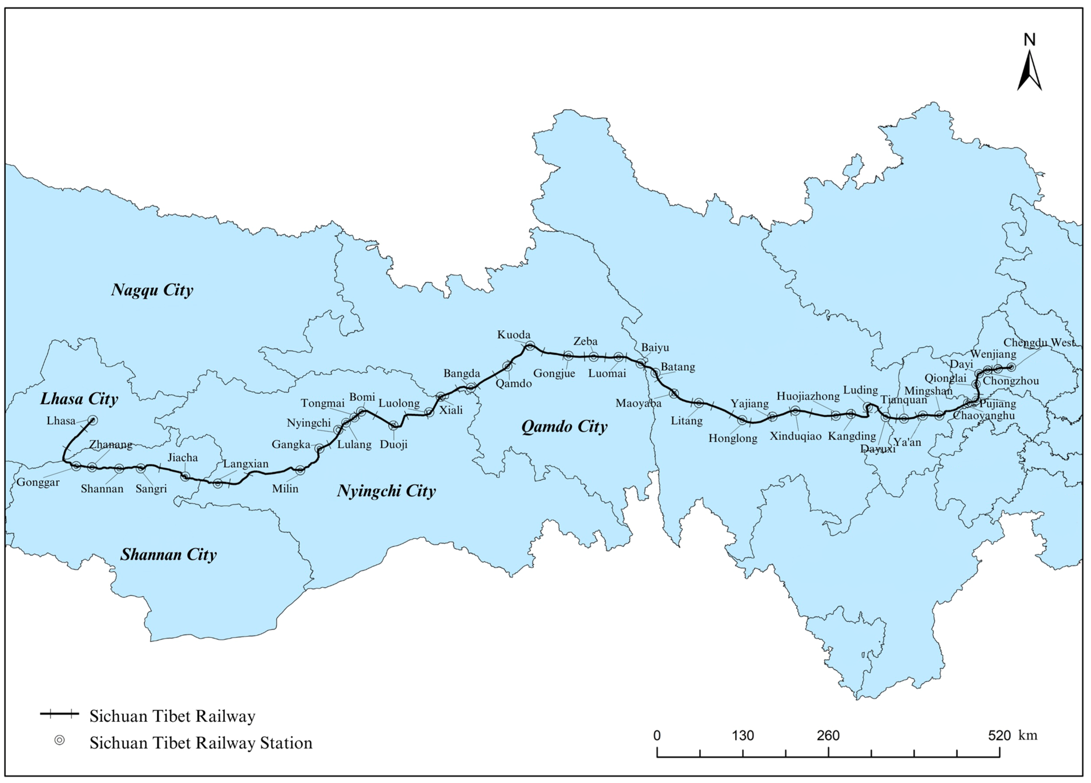
2.1. Study Area

The Tibet (Tibet Autonomous Region) is located in southwestern China, with geographical coordinates ranging from 26°50′ N to 36°53′ N and 78°25′ E to 99°06′ E. The total area of Tibet is 1.23 million km2, administratively divided into 7 prefecture-level units which are composed of 74 county-level administrative divisions (8 municipal districts and 66 counties). Due to multiple constraints such as the natural environment and infrastructure conditions, railway development in Tibet has been relatively underdeveloped, but it has gained significant momentum over the past few decades. By 2021, the operational railways in Tibet included the Qinghai–Tibet Railway and the Lhasa–Nyingchi section of the Sichuan–Tibet Railway, with a total railway operating length of 1359 km and an electrified mileage of 435 km. The railway network density has reached 11.3 km per 10,000 km2, and railways have connected five prefecture-level administrative regions, including Lhasa, Nagqu, Shigatse, Nyingchi, and Shannan.
The Sichuan–Tibet Railway is the railway connecting Tibet and Sichuan Province. It is the second railway providing access to Tibet from mainland China (Figure 1). The Sichuan–Tibet Railway starts in Chengdu, Sichuan Province, and ends in Lhasa, Tibet, with a total design length of 1588 km and a design speed of 120–200 km/h. As of 2023, the Sichuan–Tibet Railway is being constructed and operated in stages, with the section of Chengdu-Ya’an railway and Lhasa-Nyingchi railway already operational. According to its plan, once fully operational, the Sichuan–Tibet Railway will significantly reduce the transport cost for Tibet, improve the regional railway network layout, and boost the overall transportation service capacity of Tibet. Therefore, a scientific analysis of the accessibility improvements brought by the Sichuan–Tibet Railway holds important practical significance.

2.2. Data

The transportation network data includes highway and railway network data for Tibet from 2020, 2021, and 2022, sourced from OpenStreetMap. The railway data is also refined by combining the National Railway Planning Map, the 13th Five Year Plan of Xizang Autonomous Region, as well as the Sichuan Tibet railway stations provided on the public website (https://baike.baidu.com). For the calculation of internal and external accessibility, the shortest travel time between the 74 counties in Tibet and from each county to regional hub cities was calculated using the OD cost matrix, constructed via network analysis methods in ArcGIS 10.2. Detailed methods can be found in Section 3.2.1. For external accessibility, we also integrated the passenger train timetable on the 12306 China Railway website. Specifically, for routes with direct train services, the application automatically selects the fastest route based on the train schedule and displays the travel time. For routes without direct train services, the application automatically generates multiple segments and calculates the shortest total travel time by considering the minimum transfer and layover times, which are determined based on the train schedule. Socio-economic data, such as population size and gross domestic product (GDP), was sourced from the 2021 China Statistical Yearbook (County-Level).

3. Study Methods

3.1. Research Scenario Setting

This paper defines three scenarios according to the different stages of the opening of the Sichuan–Tibet Railway (Table 1). By comparing data under different scenarios and using ArcGIS 10.2 software for data visualization, the goal is to reveal the specific effects of the Sichuan–Tibet Railway on accessibility improvement in Tibet [27,28].

3.2. Accessibility Measurement

The methodology of this study is divided into three components: shortest travel time, weighted average travel time, and external average travel time. The shortest travel time serves as the basic indicator, measuring the minimum travel time between counties. Weighted average travel time builds upon this by incorporating node weights, reflecting the impact of the nodes’ connectivity on accessibility. External average travel time takes an external perspective, evaluating the improvements in transportation connections between Tibet and external core cities, particularly the role of railways in enhancing these linkages.

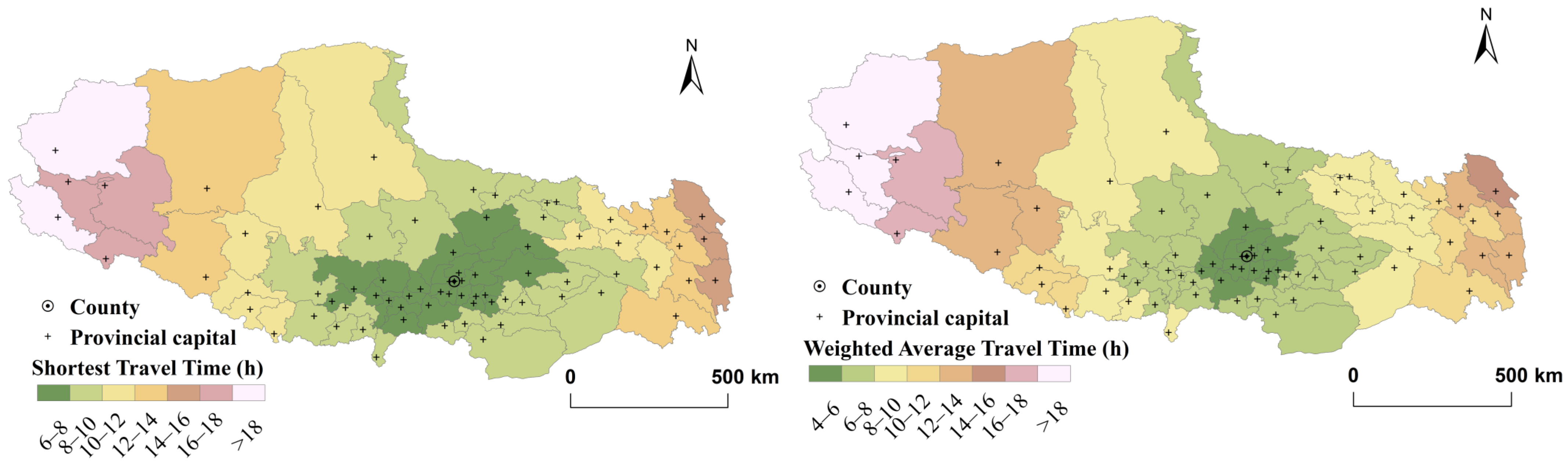
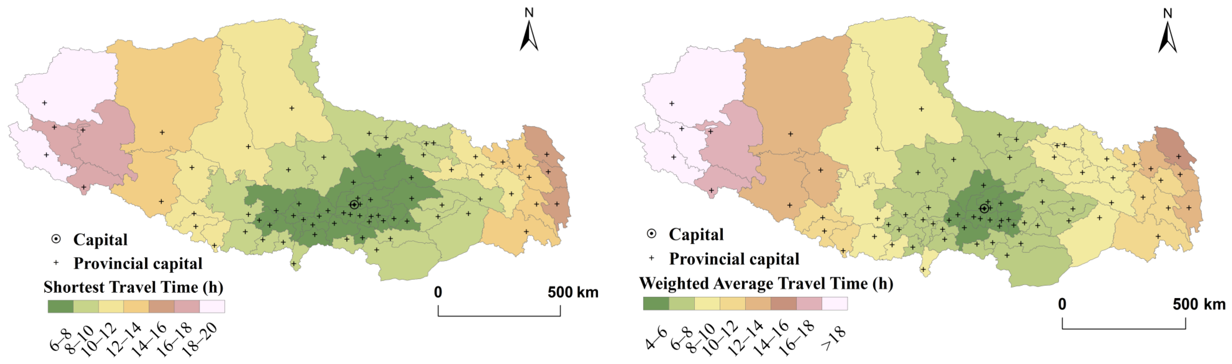
3.2.1. Shortest Travel Time

The shortest travel time is an indicator that measures accessibility based on time. It refers to the minimum time required to travel from one node to another in each set of nodes [29]. It is a crucial part of GIS network analysis and forms the foundation for calculating other accessibility indicators such as weighted average travel time in this paper.
The specific operation in this section involves using the network analysis tool in ArcGIS 10.2 to import road and railway networks under different scenarios, perform basic data processing such as topological error checking and resolving intersecting lines, and then add speed attributes to the roads. This allows for the construction of a transportation network dataset for Tibet. Based on this, the county seats of the 74 counties in Tibet are used as origin and destination points. Using road travel time as the cost field, an OD cost matrix consisting of 2701 lines between counties is established to obtain the shortest paths between counties and their corresponding minimum travel times, referred to as the shortest travel time for each county. These calculations are performed within the attribute table.
When assigning road speeds, this paper references the road classifications in OpenStreetMap and the road design speeds specified in the “Highway Engineering Technical Standard of the People’s Republic of China (JTGB01-2014)” [30]. The following speeds are used for the calculations: high-speed railway at the design speed of each line, conventional railway at 120 km/h, expressway at 100 km/h, first-class roads and main roads at 80 km/h, second-class roads at 60 km/h, third-class roads at 30 km/h, and other roads at 10 km/h.

3.2.2. Weighted Average Travel Time

The weighted average travel time incorporates the influence of node weights into the average shortest travel time between nodes, which not only directly reflects the accessibility level of a node but also captures the impact of differences in urban size, population, and economic development on the spatial pattern of accessibility [31]. This is a commonly used indicator to measure regional accessibility from the perspective of time cost, and its specific formula can be expressed as:
A i = j = 1 n ( T i j × M j ) j = 1 n M j
where Tij is the shortest travel time from node i to node j; Mj represents the weight of node j, reflecting the radiation or attraction capacity of this node to the surrounding areas. This can be represented by indicators such as regional GDP, total population, or total social goods sales. In this paper, the geometric mean of the population size and regional GDP of the node is used as the weight, that is, Mj = P j G j , where Pj is the population size of node j, and Gj is the regional GDP of node j. n represents the total number of nodes in the transportation network excluding node i; Ai is the weighted average travel time of node i, which is negatively correlated with the accessibility of node i. The smaller the value of Ai, the shorter the weighted average travel time and the better the accessibility of node i.

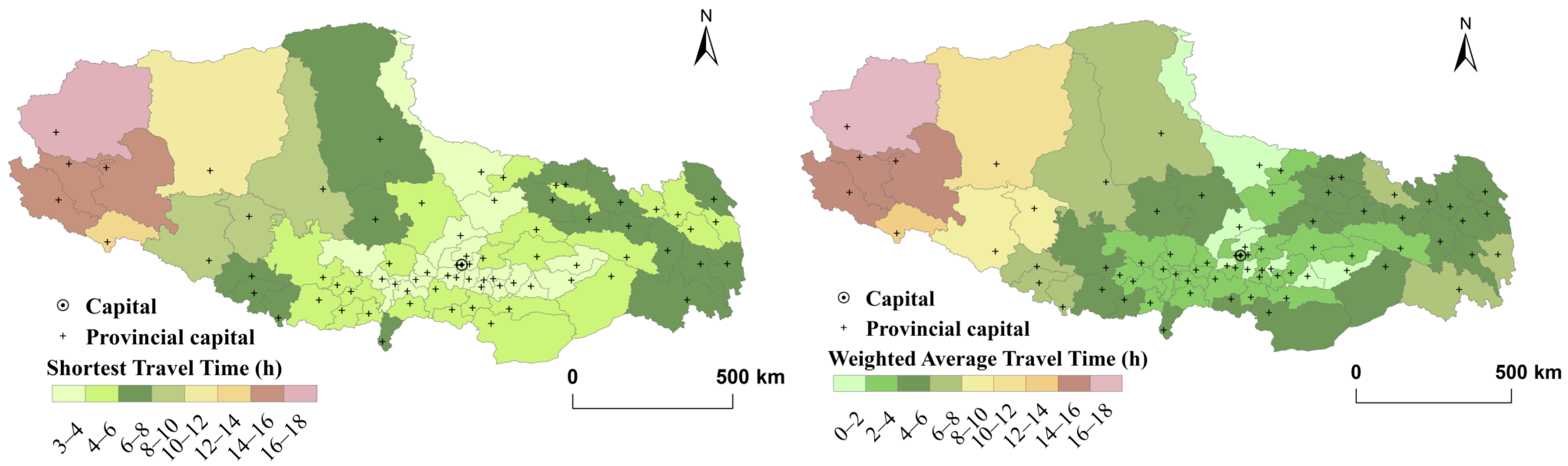
3.2.3. External Average Travel Time

External average travel time is an important indicator for measuring the level of external accessibility of a region. In this paper, railways are chosen as the primary mode of transportation for calculating external accessibility. The specific formula can be expressed as:
T i j = j = 1 n ( T i + T j ) n
where Ti is the shortest travel time from node i to the regional transit city; Tj is the shortest travel time from the regional transit city to node j; n is the number of cities represented by node j; and Tij is the external average travel time between node i and node j. It is negatively correlated with the external accessibility of node i, meaning that the smaller the value of Tij, the shorter the external average travel time, and the better the external accessibility of node i.
For this study, node i refers to the 74 counties in Tibet. In the scenario where the Sichuan–Tibet Railway has not yet opened, Nagqu City along the Qinghai–Tibet Railway is selected as the regional transit city. In the scenario where the entire Sichuan–Tibet Railway is open, the capital city of Tibet, Lhasa, is selected as the regional transit city. For node j, four directly administered municipalities and six national regional central cities in China are chosen, namely Beijing, Shanghai, Tianjin, Chongqing, Shenyang, Nanjing, Wuhan, Shenzhen, Chengdu, and Xi’an.

3.2.4. Coefficient of Variation

The coefficient of variation (CV) is the ratio of the sample standard deviation to the mean and is a statistic that measures the degree of balance among the data in the study sample [32]. The specific formula is as follows:
C V = 1 W 1 n 1 i = 1 n ( W i W ¯ ) 2
where CV is the coefficient of variation; n is the number of research units; W ¯ represents the average accessibility of all research units; W is the accessibility value of the i-th research unit. This paper uses the coefficient of variation to verify whether the opening of the Sichuan–Tibet Railway will enhance or reduce regional accessibility differences. It reflects the relative gap between the accessibility of each county and the overall regional accessibility. The larger the coefficient of variation, the greater the disparity in regional accessibility, and the lower the degree of balance.

4. Results

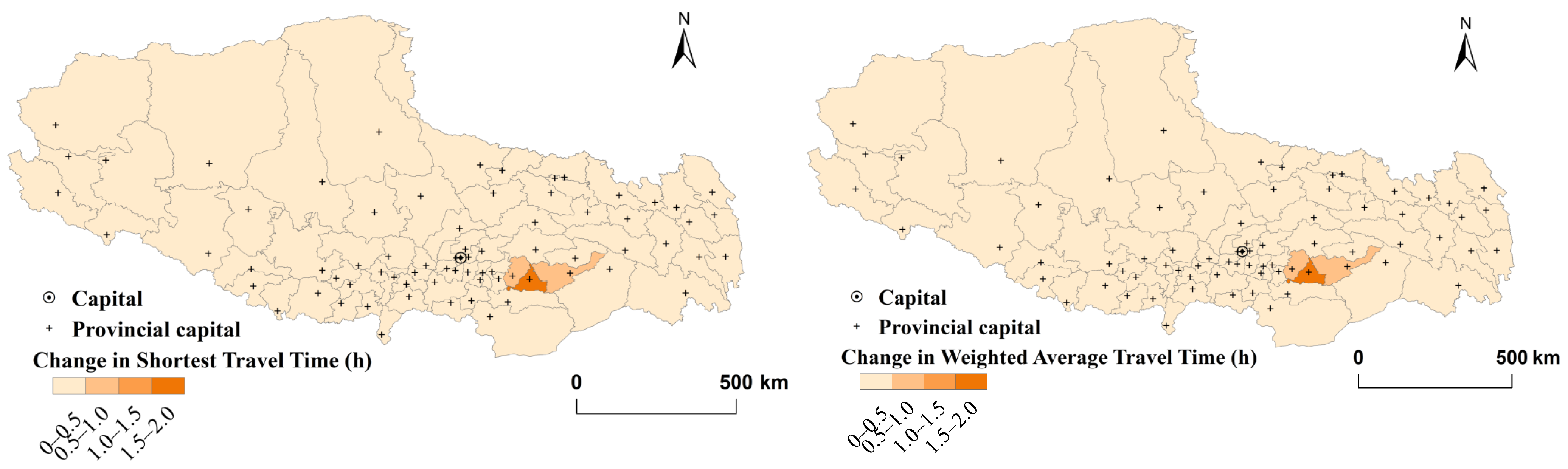
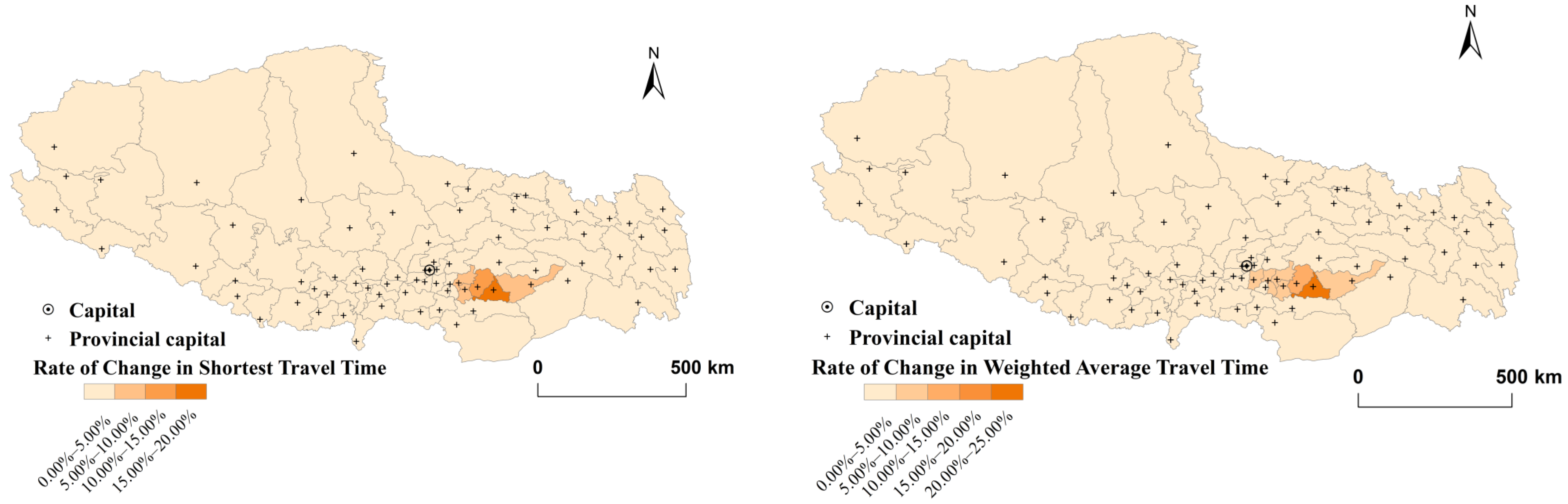
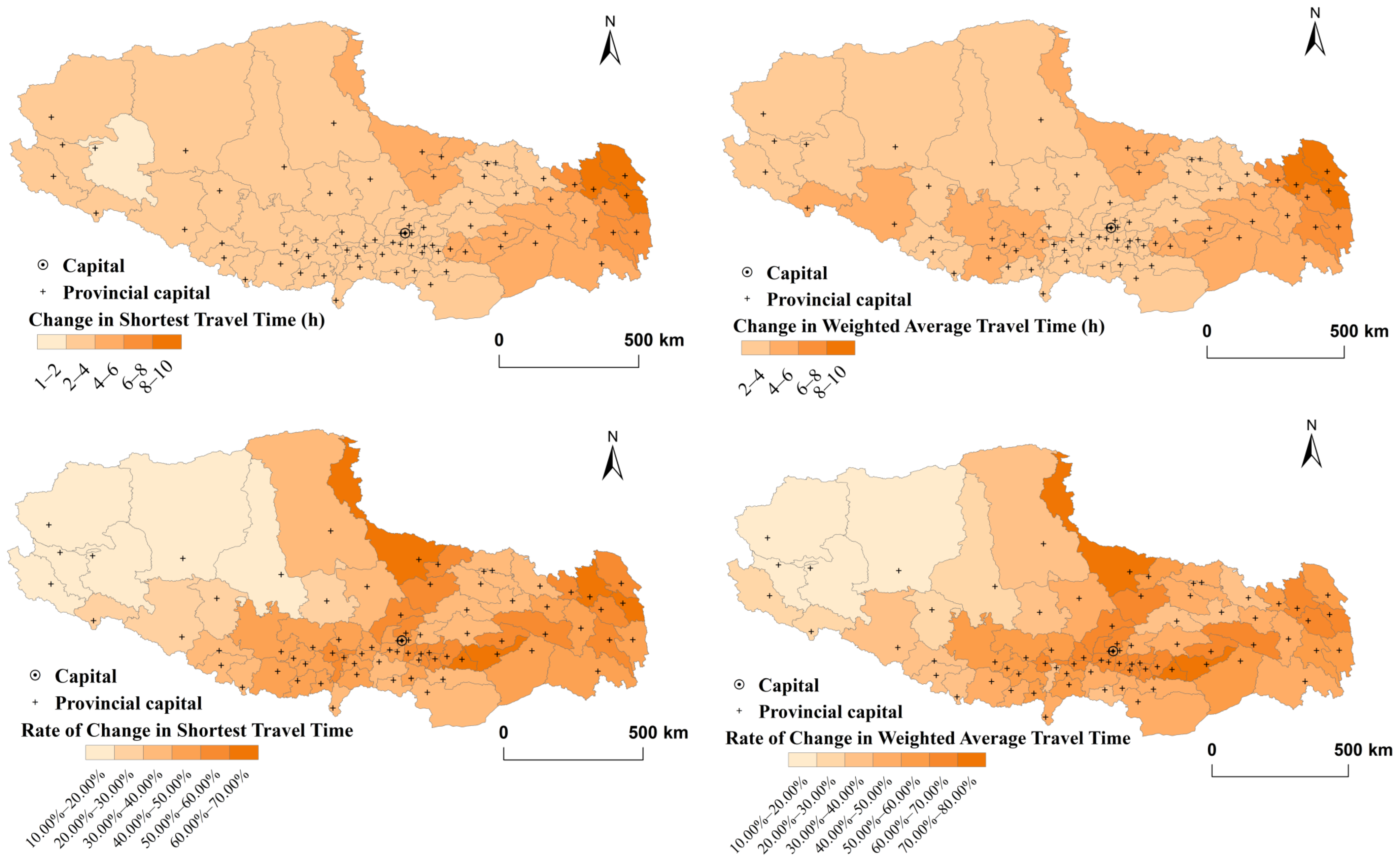
4.1. Internal Traffic Accessibility and Changes

Before the opening of the Sichuan–Tibet Railway, the overall travel time within Tibet was relatively high, indicating poor accessibility. The average shortest travel time within the region was 9.8 h, and the weighted average travel time was 8.9 h. The spatial distribution of accessibility formed an irregular ring pattern, with Lhasa as the core, gradually expanding outward to the peripheral areas (Figure 2).
The main stations along the Lhasa–Nyingchi Railway line of the Sichuan–Tibet Railway include Lhasa, Nyingchi, Milin, Lang, and Gongga. After the operation of the railway, the accessibility of the regions along the railway, such as Nang County, Gyaca County, Mainling County, Sangri County, Qusum County, and Medog County, saw significant improvements, with the shortest travel time and weighted average travel time both improving by more than 30 min. The average shortest travel time in Tibet decreased from 9.80 h before the opening to 9.63 h, having a relatively small impact on the overall internal accessibility of the region (Figure 3).
Once the entire Sichuan–Tibet Railway is fully operational, the internal travel time in Tibet will see a significant reduction, and the areas with high accessibility will expand. The overall level of accessibility will greatly improve, with the average shortest travel time between counties reducing by 40%, shortening to 5.8 h. From the perspective of weighted average travel time, 80% of the region will experience a reduction of 2–5 h, and 20% will see reductions of more than 5 h, with the average travel time falling to 4.8 h. Among these, the accessibility of Lhasa, Nagqu, Shigatse, and Nyingchi will be significantly higher than in other areas, with shortest travel times ranging from 3 to 4 h and weighted average travel times between 1 and 4 h. Although the accessibility in other regions will also improve, the gap between these areas and the core regions with dense transportation networks will further widen. The spatial distribution of accessibility forms a pattern radiating outward from the areas along the Qinghai–Tibet and Sichuan–Tibet Railways (Figure 4).
A deeper exploration of the accessibility improvement magnitude and rate reveals that the internal accessibility optimization triggered by the Lhasa–Nyingchi Railway exhibits notable differences. The accessibility improvement along the railway stations is significantly higher than in non-railway regions, showing a directional trend along the transportation line. In particular, Nang County, Gyaca County, and Mainling County will experience significant reductions in travel times, with the shortest travel times decreasing by 1.6 h, 0.9 h, and 0.6 h, respectively. Nang County sees the highest improvement, with a 21% reduction in weighted average travel time, greatly lowering the time cost for travel in this area (Figure 5). The entire opening of the Sichuan–Tibet Railway will have a significant impact on the overall accessibility improvement in Tibet, with more than half of the areas achieving an accessibility improvement rate of over 50%. The spatial distribution of the change rate still shows a directional trend, with the highest improvement rates occurring along the Qinghai–Tibet and Sichuan–Tibet Railways, while non-railway regions see a relative weakening of their locational advantage and less significant accessibility improvements. In summary, the opening of the Sichuan–Tibet Railway significantly improves internal transportation accessibility in Tibet, but the effect is uneven, with substantial differences in improvement rates across different areas within the region (Figure 6).

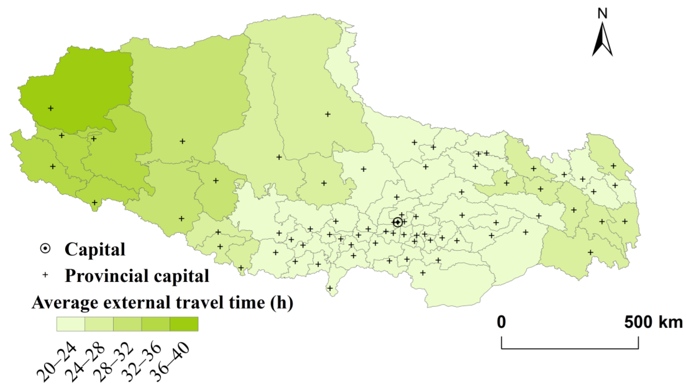
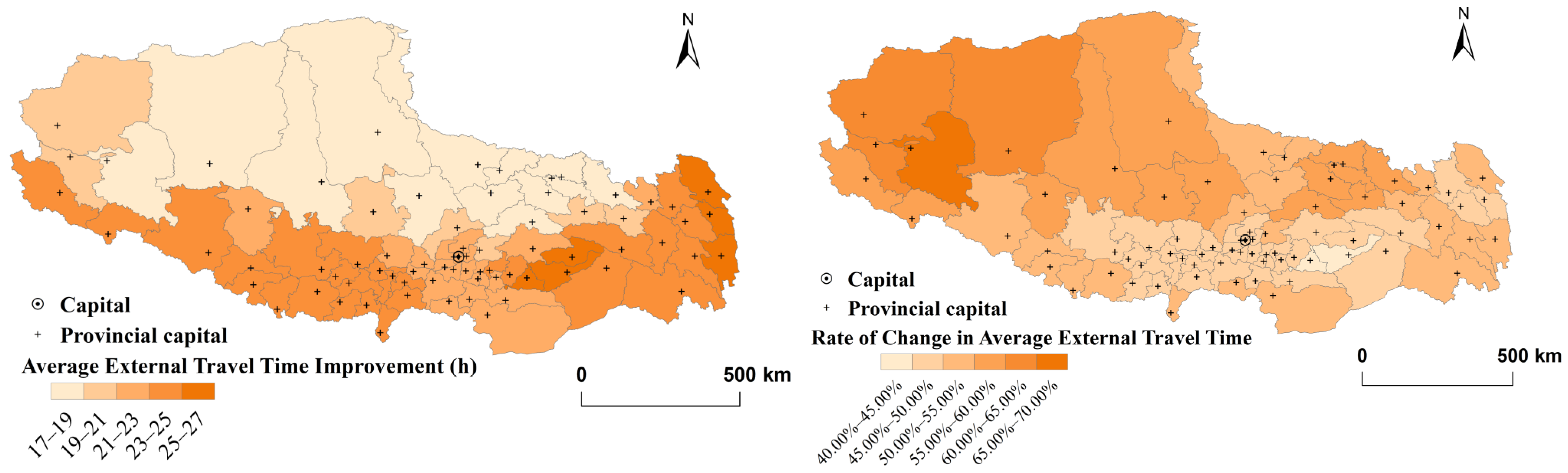
4.2. External Traffic Accessibility and Changes

Before the Sichuan–Tibet Railway’s inauguration, Tibet’s 74 counties and China’s 4 municipalities, 6 national capital cities could be reached by train in an average of 45.7 h. Low-value areas were mainly concentrated in Nagqu and Lhasa, which lie along the Qinghai–Tibet Railway, indicating relatively good external accessibility due to the clear directional nature of the transportation artery. High-value areas were concentrated in the peripheral cities, such as Ngari and Chamdo, where external accessibility was poor, mainly due to their distance from central cities, more challenging natural conditions, and greater difficulties in road construction. The spatial pattern of average external travel time formed a radiating pattern centered on Nagqu, with values gradually increasing toward the peripheral areas, showing an east–west radiation pattern along the Qinghai–Tibet Railway (Figure 7).
After the opening of the Sichuan–Tibet Railway, the average external travel time by rail decreased to 23.7 h, with an average improvement of 22 h. More than 70% of the region will see external travel times reduced to less than 24 h, significantly improving the overall level of external accessibility. With the continued improvement in the railway and highway network, the external accessibility of peripheral areas far from central cities also significantly improves. From a spatial perspective, the directional nature of transportation arteries becomes more prominent after the opening of the Sichuan–Tibet Railway. Regions along and near the railway will generally have lower external travel times, while the values increase as the distance from the railway grows, with the highest values found in peripheral areas. The external accessibility will still be centered around Lhasa, Nagqu, Shigatse, and Nyingchi, with accessibility levels decreasing outward from these cities (Figure 8).
In terms of the magnitude and rate of improvement in external accessibility, the areas with the greatest improvement are concentrated in the southeastern and southwestern parts of Tibet, particularly in areas with relatively poor external accessibility before the railway’s opening. Ngari, in the western part of Tibet, will experience the greatest improvement in average external travel time, with a rate exceeding 60%, reflecting the significant impact of the railway in improving the external accessibility of peripheral areas and reducing their locational disadvantage [33]. Other areas will also see improvement rates of over 40%, indicating that the opening of the Sichuan–Tibet Railway can significantly improve external transportation conditions and greatly promote communication between Tibet and central and eastern regions (Figure 9).

4.3. Equity Analysis

By calculating the coefficients of variation for the internal weighted average travel time and external average travel time in different scenarios (Table 2), the data show that after the opening of the Sichuan–Tibet Railway, the coefficients of variation for both internal and external accessibility increased. This indicates that the degree of balance in internal and external accessibility within Tibet is decreasing. In other words, while the Sichuan–Tibet Railway creates more development opportunities for areas along the railway, it may also enlarges the accessibility gap between counties, exacerbating inequality within the region [31,34].

5. Discussion

From the perspective of this study, the Sichuan–Tibet Railway can effectively enhance the railway network structure of Tibet, significantly improving its transportation conditions. During the study, the accessibility results of Tibet displayed a pronounced alignment with major transportation corridors. Specifically, areas along the Sichuan–Tibet Railway and Qinghai–Tibet Railway saw a substantial reduction in the overall time-space distance and exhibited high levels of accessibility. However, regions at the provincial borders, far from the main transportation networks, remained low-access areas, leading to significant spatial differences in regional accessibility. This is consistent with previously published results [4,35,36,37] which to some extent had found the unfair trend of transportation services caused by transportation infrastructure construction.
However, this finding is also significantly different from the existing research results on Tibet. Refs. [38,39] confirmed that with the construction of transportation infrastructures, the transport service in Tibet showed the characteristic of tending towards equalization. Possible reasons may lie in the uniqueness of the railways, as well as the different research periods with the above research. As a large-scale regional transportation infrastructure, railways may have a stronger impact than highways.
At the same time, improved transportation accessibility can lead to broader socio-economic impacts. For example, in terms of employment, optimizing transportation networks can enhance labor market mobility, create more job opportunities for residents in remote areas, and reduce economic isolation. In the education sector, improved transportation conditions will facilitate students’ access to high-quality educational resources, thereby raising the overall education level in the region. Therefore, future transportation planning should strive to better balance transportation equity and regional coordinated development, fully leveraging the critical role of the transportation infrastructure in promoting socio-economic integration.
The study’s findings suggest that differentiated policies should be implemented for regions with varying levels of accessibility. For regions with low accessibility, infrastructure construction should be prioritized to expand road network coverage and strengthen connections with core cities. This will improve market accessibility and economic vitality, promote the efficient flow of talent, capital, and technology, and provide residents with greater access to education, healthcare, and social services. Ultimately, this will enhance intra-regional accessibility and narrow the disparities in accessibility between regions. For regions with high accessibility, efforts should focus on further tapping into their accessibility potential by strengthening the construction of high-grade transportation infrastructure, enhancing their regional influence, and maximizing the benefits of major transportation corridors.
From an economic perspective, such measures will strengthen economic cooperation between Tibet and neighboring provinces, form cross-regional industrial chains and economic clusters, and drive Tibet’s industrial transformation and upgrading, laying a solid foundation for regional integration. From a social perspective, improved transportation can bring more employment, healthcare, and educational opportunities to underdeveloped areas, reduce both geographical and psychological distances, and foster cultural exchange and integration, thereby promoting deeper socio-economic integration across regions.
In addition, some limitations remain. Firstly, the scenario in this study involves routes that are not yet operational, and the acquisition of road network data are thus constrained. Consequently, this research relies predominantly on planned transportation infrastructure data, and discrepancies may exist between the planned and actual routes. The potential impacts of these discrepancies on the results have not been fully addressed. Additionally, the traffic speed parameters used in the study are based on idealized assumptions, without accounting for the unique natural environmental factors of Tibet, such as its complex topography and harsh climatic conditions. These factors could significantly affect actual travel speeds, leading to discrepancies between the modeled traffic parameters and real-world conditions. As such, these limitations may reduce the accuracy and practical applicability of the results to some extent.
Future research could further explore the significance of the development of transportation infrastructure in the Tibetan Autonomous Region and its role in enhancing regional overall accessibility, while also delving into the comprehensive benefits and long-term impacts of this improvement. Additionally, it could attempt to incorporate more real-world conditions by adopting more complex models and diversified GIS methods to evaluate the effectiveness of transportation infrastructure development in improving accessibility across different regions. For example, considering the unique natural environment of Tibet, a more detailed investigation could explore how these factors can be integrated into transportation network analysis to enhance the model’s practical applicability and accuracy, thereby enabling a comprehensive evaluation of the social and economic benefits of transportation infrastructure development. Another promising research direction is the evaluation of the future development of transportation connections between Tibet and external core cities. With the construction of new routes, such as the Xinjiang–Tibet Railway, Yunnan–Tibet Railway, the “Two Horizontal, Three Vertical” railway corridors, and the South Asia-facing international railway corridor, further studies could explore the specific impacts of these new lines on improving regional transportation accessibility, as well as how they may reshape the transportation network structure and economic ties both within and outside the region.

6. Conclusions

Based on multi-source data and utilizing GIS spatial analysis methods, this study quantitatively analyzed the changes in internal and external transportation accessibility across counties in different scenarios of the Sichuan–Tibet Railway’s operation. The key conclusions are as follows:
(1)
The internal and external transportation accessibility of all counties in Tibet has significantly improved after the opening of the Sichuan–Tibet Railway, with a notable space-time convergence effect. Once the railway is fully operational, the average reduction in internal accessibility travel time for each county is 4 h, while the average reduction in external accessibility travel time is 22 h, effectively shortening both intra-provincial and inter-provincial travel times.
(2)
The spatial pattern of accessibility in Tibet has limited changes before and after the Sichuan–Tibet Railway’s operation. The areas with the highest accessibility remain in the intersecting regions of the Qinghai–Tibet and Sichuan–Tibet Railways. The overall spatial pattern shows Lhasa, Nyingchi, Shigatse, and Nagqu as the core areas, radiating outwards to surrounding regions.
(3)
The degree of accessibility optimization brought by the Sichuan–Tibet Railway varies across different regions. In terms of internal accessibility, the regions along the Sichuan–Tibet Railway and the intersecting areas with the Qinghai–Tibet Railway experienced a change rate of 50–80%, showing a more significant improvement in accessibility. This demonstrates a clear transportation corridor-oriented pattern. In terms of external accessibility, the areas with the greatest improvement are the peripheral regions that had low accessibility levels and poor connectivity before the railway’s opening. This indicates that the operation of the Sichuan–Tibet Railway also exerts a significant spillover effect on improving the accessibility of areas surrounding the railway, significantly enhancing the convenience of connections between peripheral and central cities.

Author Contributions

Conceptualization, Y.M. and Y.D.; methodology, Y.D.; software, Y.D.; validation, Y.D. and Y.M.; formal analysis, Y.D. and Y.M.; resources, Y.D. and Y.M.; data curation, C.T.; writing—original draft preparation, Y.D. and Y.M.; writing—review and editing, Y.D. and C.T.; visualization, Y.D.; supervision, Y.M.; project administration, Y.M.; funding acquisition, Y.M. All authors have read and agreed to the published version of the manuscript.

Funding

This research was funded by National Natural Science Foundation of China (Grant number: 42201182).

Institutional Review Board Statement

Not applicable.

Informed Consent Statement

Not applicable.

Data Availability Statement

All data used in this study are publicly available on the websites mentioned in Section 2.2.

Acknowledgments

Thank you to all the experts and scholars who have provided guidance for this study.

Conflicts of Interest

The authors declare no conflicts of interest.

References

  1. Wang, J.; Ding, J. High-speed Rail and Its impacts on the Urban Spatial Structure of China. Urban Plan. Int. 2011, 26, 49–54. (In Chinese) [Google Scholar]
  2. Jin, F.; Jiao, J.; Qi, Y.; Yang, Y. Evolution and geographic effects of high-speed rail in East Asia: An accessibility approach. J. Geogr. Sci. 2017, 27, 515–532. [Google Scholar] [CrossRef]
  3. Zhong, Y.; Huang, J.; Wen, Y. Impact of High-speed Railway on Spatial Pattern of Chinese Cities’ Accessibility. Sci. Geogr. Sin. 2015, 35, 387–395. (In Chinese) [Google Scholar]
  4. Jiao, J.; Wang, J.; Jin, F.; Dunford, M. Impacts on accessibility of China’s present and future HSR network. J. Transp. Geogr. 2014, 40, 123–132. [Google Scholar] [CrossRef]
  5. Martínez Sánchez-Mateos, H.S.; Givoni, M. The accessibility impact of a new High-Speed Rail line in the UK—A preliminary analysis of winners and losers. J. Transp. Geogr. 2012, 25, 105–114. [Google Scholar] [CrossRef]
  6. Gao, X.; Wang, B.; Sun, D. Do railways improve territorial cohesion of the Tibetan Plateau? A case study of the Qinghai-Tibet Railway. Appl. Geogr. 2022, 144, 102720. [Google Scholar] [CrossRef]
  7. Pyrialakou, V.D.; Gkritza, K.; Fricker, J.D. Accessibility, mobility, and realized travel behavior: Assessing transport disadvantage from a policy perspective. J. Transp. Geogr. 2016, 51, 252–269. [Google Scholar] [CrossRef]
  8. Hou, Q.; Li, S. Transport infrastructure development and changing spatial accessibility in the Greater Pearl River Delta, China, 1990–2020. J. Transp. Geogr. 2011, 19, 1350–1360. [Google Scholar] [CrossRef]
  9. Xu, W.; Zhou, J.; Yang, L.; Li, L. The implications of high-speed rail for Chinese cities: Connectivity and accessibility. Transport. Res. A-Pol. 2018, 116, 308–326. [Google Scholar]
  10. Hansen, W.G. How Accessibility Shapes Land Use. J. Am. Plann. Assoc. 1959, 25, 73–76. [Google Scholar] [CrossRef]
  11. Liang, Y.; Zhou, K.; Lin, X.; Zhou, Z.; Sun, W.; Zeng, J. Effectiveness of high-speed railway on regional economic growth for less developed areas. J. Transp. Geogr. 2020, 82, 02621. [Google Scholar] [CrossRef]
  12. Cui, J.; Li, X.; Chu, N. Coordination research of high-speed rail accessibility and economic-social development level in less developed areas. Econ. Geogr. 2020, 40, 43–51. (In Chinese) [Google Scholar]
  13. Wu, L.; Song, X.; Yin, F. Impact of high-speed railway network on county-level accessibility and economic linkage in Jiangxi Province, China: A spatio-temporal data analysis. Open Geosci. 2024, 16, 20220678. [Google Scholar] [CrossRef]
  14. Zhou, R.; Yu, Y.; Wang, Z.; Dong, L.; Luo, X. The spatially differentiated impact of high-speed railway on accessibility and socio-economic development of developing regions: A study in southwest China. Socio-Econ. Plann. Sci. 2024, 95, 102037. [Google Scholar] [CrossRef]
  15. Yu, N.; Jin, Y. The unintended economic impact of high-speed rail on China’s non-core cities: A spatial-difference-in-differences analysis. Cities 2023, 143, 104618. [Google Scholar] [CrossRef]
  16. Yang, X.; Qiu, X.; Fang, Y.; Xu, Y.; Zhu, F. Spatial variation of the relationship between transport accessibility and the level of economic development in Qinghai-Tibet Plateau, China. J. Mt. Sci. 2019, 16, 1883–1900. [Google Scholar] [CrossRef]
  17. Gong, Q.; Li, J.; Wu, L.; Zhu, M.; Luo, M.; Sun, J.; Fu, W.; Ma, R.; Liang, X. Exploring Accessibility and Its Impact in the Mountain City: A Typical Case Study of Nyingchi City, Tibet Autonomous Region, China. Land 2023, 12, 361. [Google Scholar] [CrossRef]
  18. Gao, X.; Li, T.; Cao, X. Spatial Fairness and Changes in Transport Infrastructure in the Qinghai-Tibet Plateau Area from 1976 to 2016. Sustainability 2019, 11, 589. [Google Scholar] [CrossRef]
  19. Gao, D.; Li, S. Spatiotemporal impact of railway network in the Qinghai-Tibet Plateau on accessibility and economic linkages during 1984–2030. J. Transp. Geogr. 2022, 100, 103332. [Google Scholar] [CrossRef]
  20. Miao, Y.; Lu, W.; Dai, T.; Song, J. Comprehensive traffic advantage degree and its spatial characteristics at the prefecture level on the Qinghai-Tibet Plateau: A case study of Linzhi City. Prog. Geogr. 2021, 40, 1332–1343. (In Chinese) [Google Scholar] [CrossRef]
  21. Yu, T.; Yan, J.; Wu, Y. Study on Time-space Compression Effect Pattern of County Traffic Accessibility in Tibet. Areal Res. Dev. 2022, 41, 26–30+43. (In Chinese) [Google Scholar]
  22. Liu, Q.; Lu, W.; Dai, T.; Song, J.; Liu, Y.; Li, J. Evaluation of road accessibility in the Qinghai-Tibet Plateau region considering seasonality. Prog. Geogr. 2023, 42, 687–700. (In Chinese) [Google Scholar] [CrossRef]
  23. Dai, T.; Guo, K.; Wu, J.; Zhang, L. Accessibility improvement and landscape ecological effect of highway development in Tibet. Prog. Geogr. 2023, 42, 1882–1890. (In Chinese) [Google Scholar] [CrossRef]
  24. Li, S.; Gong, J.; Deng, Q.; Zhou, T. Impacts of the Qinghai-Tibet Railway on Accessibility and Economic Linkage of the Third Pole. Sustainability 2018, 10, 3982. [Google Scholar] [CrossRef]
  25. Jiang, H.; Zhang, W.; Qi, Y.; Liang, Z. Research progress on accessibility to regional transportation infrastructure. Prog. Geogr. 2013, 32, 807–817. (In Chinese) [Google Scholar]
  26. Wang, J.; Du, D. Building Strong Transportation Network for Serving Chinese-style Modernization: Connotation Analysis and Discipline Development. Econ. Geogr. 2023, 43, 6–14. (In Chinese) [Google Scholar]
  27. Huang, J.; Xiong, M.; Wang, J.; Gao, Y.; Li, Y. Temporal efficiency of cross-border railways with multiple simulation scenarios: A case study of the China-Laos Railway. Sci. Geogr. Sin. 2024, 44, 91–98. (In Chinese) [Google Scholar]
  28. Stepniak, M.; Rosik, P. Accessibility improvement, territorial cohesion and spillovers: A multidimensional evaluation of two motorway sections in Poland. J. Transp. Geogr. 2013, 31, 154–163. [Google Scholar] [CrossRef]
  29. Wang, D.; Wang, K.; Wang, Z.; Fan, H.; Chai, H.; Wang, H.; Long, H.; Gao, J.; Xu, J. Spatial-Temporal Evolution and Influencing Mechanism of Traffic Dominance in Qinghai-Tibet Plateau. Sustainability 2022, 14, 11031. [Google Scholar] [CrossRef]
  30. JTGB01-2014; Technical Standard of Highway Engineering. Chinese Standard: Beijing, China, 2014.
  31. Yu, M.; Fan, W. Accessibility impact of future high speed rail corridor on the piedmont Atlantic megaregion. J. Transp. Geogr. 2018, 73, 1–12. [Google Scholar] [CrossRef]
  32. Yang, J.; Guo, A.; Li, X.; Huang, T. Study of the Impact of a High-Speed Railway Opening on China’s Accessibility Pattern and Spatial Equality. Sustainability 2018, 10, 2943. [Google Scholar] [CrossRef]
  33. Luo, H.; Zhao, S. Impacts of high-speed rail on the inequality of intercity accessibility: A case study of Liaoning Province, China. J. Transp. Geogr. 2021, 90, 102920. [Google Scholar] [CrossRef]
  34. Huang, Y.; Zong, H. Has high-speed railway promoted spatial equity at different levels? A case study of inland mountainous area of China. Cities 2021, 110, 103076. [Google Scholar] [CrossRef]
  35. Cao, J.; Liu, X.; Wang, Y.; Li, Q. Accessibility impacts of China’s high-speed rail network. J. Transp. Geogr. 2013, 28, 12–21. [Google Scholar] [CrossRef]
  36. Wang, X.; Zhang, W. Efficiency and spatial equity impacts of high-speed rail on the central plains economic region of China. Sustainability 2019, 11, 2583. [Google Scholar] [CrossRef]
  37. Wang, L.; Duan, X. High-speed rail network development and winner and loser cities in megaregions: The case study of the Yangtze River Delta, China. Cities 2018, 83, 71–82. [Google Scholar] [CrossRef]
  38. Miao, Y.; Dai, T.; Song, J. Assessing the effects of the large-scale road construction on the ethnic disparities of accessibility in Tibet from 2010 to 2020. Growth Chang. 2023, 54, 754–770. [Google Scholar] [CrossRef]
  39. Miao, Y.; Dai, T.; Song, J.; Ding, T.; Lu, W. Concept expansion, method improvement of transport superiority degree and its empirical application in Tibet. Acta Geogr. Sin. 2023, 78, 1515–1529. (In Chinese) [Google Scholar]
Figure 1. The route and stations of Sichuan–Tibet Railway.
Sustainability 16 10179 g001
Figure 2. Scenario 1: The shortest travel time and weighted average travel time.
Sustainability 16 10179 g002
Figure 3. Scenario 2: The shortest travel time and weighted average travel time.
Sustainability 16 10179 g003
Figure 4. Scenario 3: The shortest travel time and weighted average travel time.
Sustainability 16 10179 g004
Figure 5. Change in accessibility levels between Scenario 1 and Scenario 2.
Sustainability 16 10179 g005aSustainability 16 10179 g005b
Figure 6. Change in accessibility levels between Scenario 1 and Scenario 3.
Sustainability 16 10179 g006
Figure 7. Scenario 1: The average external travel time.
Sustainability 16 10179 g007
Figure 8. Scenario 3: The average external travel time.
Sustainability 16 10179 g008
Figure 9. Change in the level of external accessibility of railways between Scenario 1 and Scenario 3.
Sustainability 16 10179 g009
Table 1. Study scenario setting.
ScenarioStage CharacteristicsData Composition of the Internal Transport Network Data Composition of the External Transport Network
1No opening of the Sichuan–Tibet Railway2020 Road Traffic Network Data + Qinghai–Tibet Railway (Tibet Section)2020 Road Traffic Network Data + Qinghai–Tibet Railway (Tibet Section) + Railway Connections Outside Tibet
2Partial opening of the Sichuan–Tibet Railway (Lhasa–Nyingchi section)2021 Road Traffic Network Data + Qinghai–Tibet Railway (Tibet Section) + Sichuan–Tibet Railway (Lhasa-Nyingchi section)2021 Road Traffic Network Data + Qinghai–Tibet Railway (Tibet Section) + Sichuan–Tibet Railway (Lhasa-Nyingchi section) + Railway Connections Outside Tibet
3Full Operation of the Sichuan–Tibet Railway2022 Road Traffic Network Data + Qinghai–Tibet Railway (Tibet Section) + Sichuan–Tibet Railway (Tibet Section)2022 Road Traffic Network Data + Qinghai–Tibet Railway (Tibet Section) + Sichuan–Tibet Railway (Tibet Section) + Railway Connections Outside Tibet
Table 2. Coefficients of the variation for inward and outward accessibility under different scenarios.
BeforeAfter
Coefficient of the variation in inward-weighted average travel times0.400.71
Coefficient of the variation in average external travel times0.090.16
Disclaimer/Publisher’s Note: The statements, opinions and data contained in all publications are solely those of the individual author(s) and contributor(s) and not of MDPI and/or the editor(s). MDPI and/or the editor(s) disclaim responsibility for any injury to people or property resulting from any ideas, methods, instructions or products referred to in the content.

