
Leveraging Disruptive Technologies for Faster and More Efficient Disaster Response Management


Abstract
:1. Introduction
2. Background
3. Materials and Methods
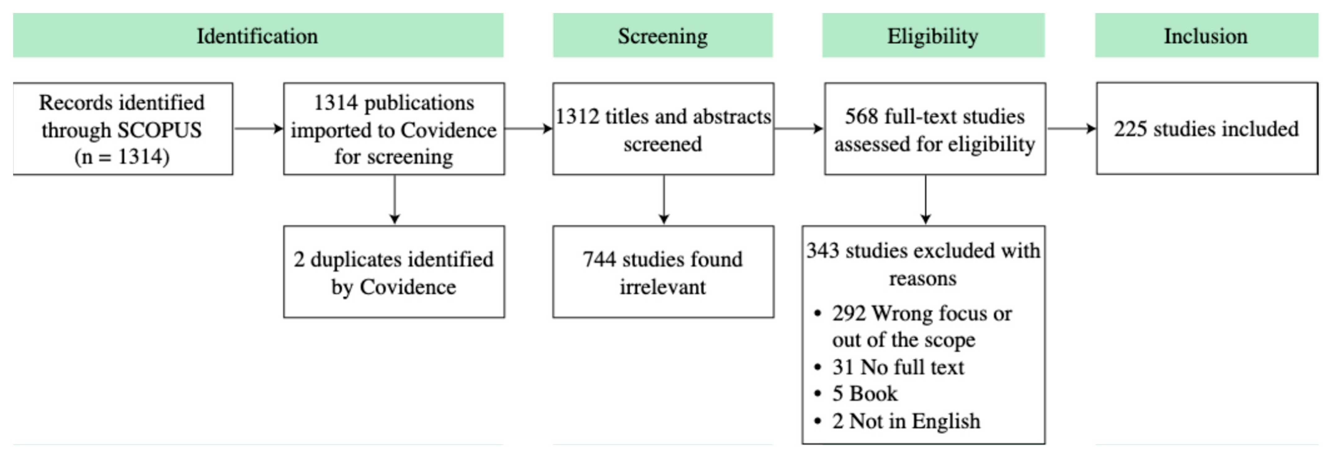
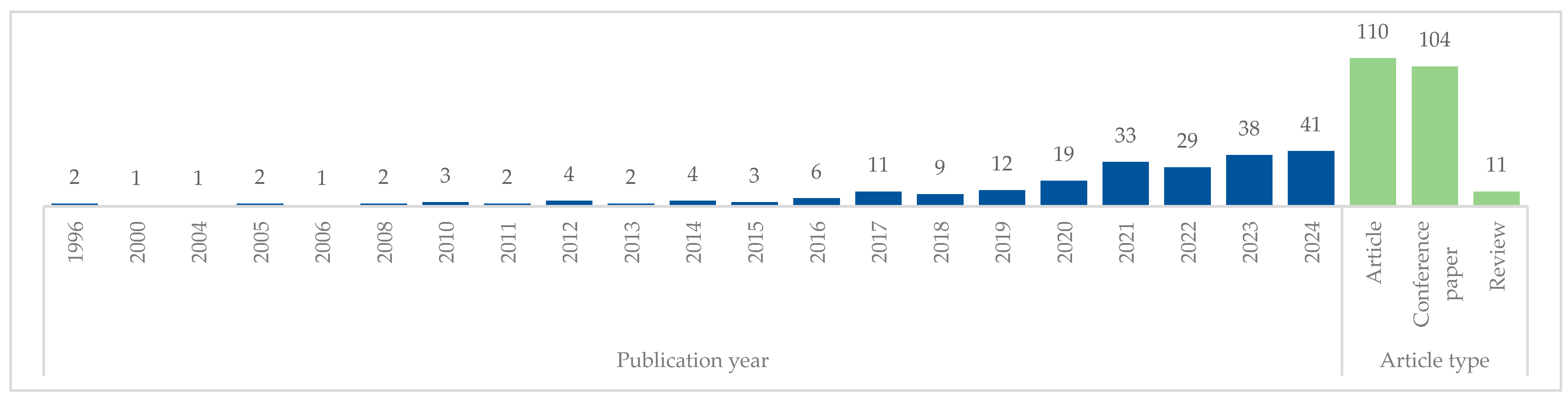
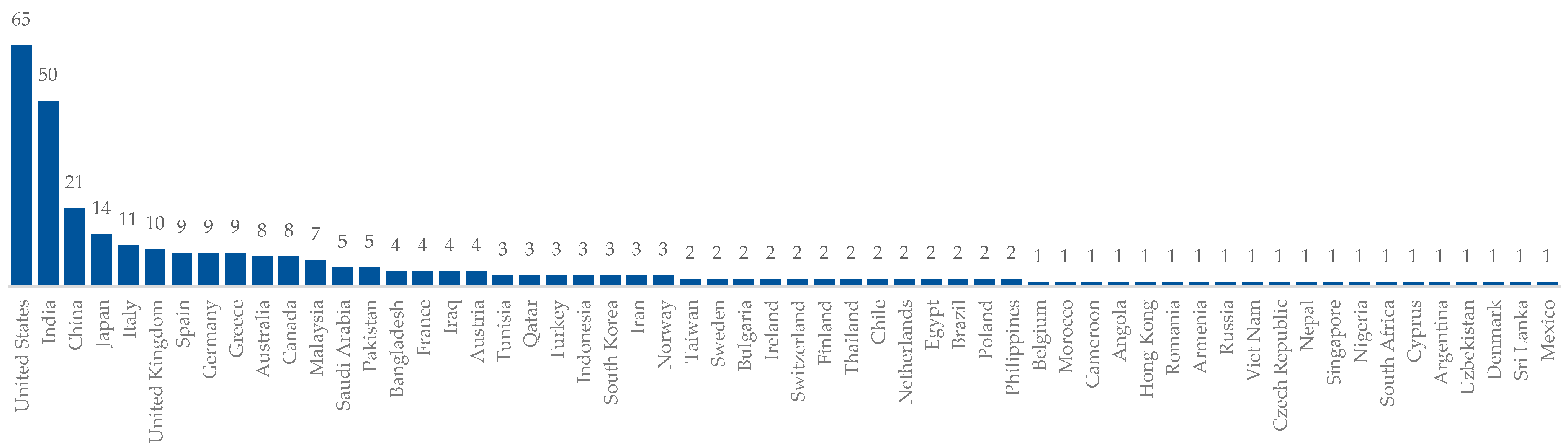
3.1. Literature Retrieval and Selection
3.2. Data Extraction and Analysis
4. Results
4.1. Artificial Intelligence (AI) in Disaster Management
4.2. Machine Learning (ML) in Disaster Management
4.3. Internet of Things (IoT) in Disaster Management
4.4. Robotics and Unmanned Aerial Vehicles (UAVs) in Disaster Management
4.5. Information and Communication Technology (ICT) in Disaster Management
4.5.1. Geospatial Analysis in Disaster Management
4.5.2. Social Media and Smartphone Applications in Disaster Management
5. Discussion
- Social barriers—Social factors play a key role in limiting the adoption of disruptive technologies. These factors include: (1) the low education levels in low-income communities, which affect behavioral intention and are critical for preparedness, prevention, and adequate response [267,268]; (2) a lack of public training and awareness of the benefits of disruptive technologies, complicating response efforts to engage the community, disaster managers, and responders in technology-driven initiatives [267,269]; (3) distrust among stakeholders, including government agencies, NGOs, private industry, local communities, and all parties involved in disaster response efforts, leading to reduced collaboration and decision-making delays [267,270]; (4) the absence of clearly defined roles, responsibilities, and coordination mechanisms, as well as a lack of engagement with technical expertise [267]; and (5) distrust and reluctance to adopt and use new technologies [271].
- Economic barriers—One of the major challenges facing low-income communities is financial constraints [2,19]. Financial factors hindering the adoption of disruptive technologies for disaster response include: (1) high levels of unemployment and poverty, as well as lack of insurance, which impedes access to resources to prepare for and effectively respond to disasters [3,19,20,267,270,272]; (2) reduced local government revenue, limiting the ability to invest in new technologies that are often expensive [267]; and (3) uneven access to financial resources, along with the delayed allocation of funding, which impacts equitable recovery and timely response [267].
- Physical barriers—The physical damage in low-income communities, which often live in informal settlements, exacerbates response and recovery difficulties [2,267,273,274]. These communities experience extensive damage to buildings, transportation systems, and other critical infrastructure, such as water, electricity, and communication networks [2,267]. Furthermore, slow debris removal and contamination hinder quick recovery [267]. These physical conditions present significant challenges for deploying and effectively implementing diverse disruptive technologies for disaster response, which often depend on stable infrastructure and reliable communication networks [56,59,90,92,139,182].
6. Limitations and Future Work
7. Conclusions
Author Contributions
Funding
Institutional Review Board Statement
Informed Consent Statement
Data Availability Statement
Conflicts of Interest
References
- Lindell, M.K.; Prater, C.S. Assessing Community Impacts of Natural Disasters. Nat. Hazards Rev. 2003, 4, 176–185. [Google Scholar] [CrossRef]
- Calle Müller, C.; Elzomor, M. Addressing Post-Disaster Challenges and Fostering Social Mobility through Origami Infrastructure and Construction Trade Education. Sustainability 2024, 16, 3415. [Google Scholar] [CrossRef]
- IFRC (International Federation of Red Cross and Red Crescent Societies). World Disasters Report 2020: Come Heat or High Water; IFRC: Geneva, Switzerland, 2020; ISBN 9782970128953. [Google Scholar]
- UNDRR; CRED. Human Cost of Disasters: An Overview of the Last 20 Years 2000–2019; CRED: Brussels, Belgium, 2020. [Google Scholar]
- Calle Müller, C.; Santaniello, P.B.; Zisis, I.; Elawady, A.; Elzomor, M. Towards Developing a Modernized Wind Engineering Curricula. In Proceedings of the 2023 ASEE Annual Conference & Exposition, Baltimore, MD, USA, 25–28 June 2023. [Google Scholar]
- Hendriks, E.; Opdyke, A. The Influence of Technical Assistance and Funding on Perceptions of Post-Disaster Housing Safety after the 2015 Gorkha Earthquakes in Nepal. Int. J. Disaster Risk Reduct. 2022, 73, 102906. [Google Scholar] [CrossRef]
- El-Anwar, O.; El-Rayes, K.; Elnashai, A. Optimizing Large-Scale Temporary Housing Arrangements after Natural Disasters. J. Comput. Civ. Eng. 2009, 23, 110–118. [Google Scholar] [CrossRef]
- He, Y.; Wu, B.; He, P.; Gu, W.; Liu, B. Wind Disasters Adaptation in Cities in a Changing Climate: A Systematic Review. PLoS ONE 2021, 16, e0248503. [Google Scholar] [CrossRef]
- Stawicki, S.A.; Papadimos, T.; Marchigiani, R.; Gordy, S.; Cipolla, J.; Adams, R.; Evans, D.; Stehly, C.; Galwankar, S.; Russell, S.; et al. Wind Disasters: A Comprehensive Review of Current Management Strategies. Int. J. Crit. Illn. Inj. Sci. 2013, 3, 130. [Google Scholar] [CrossRef]
- Pradhananga, P.; Calle Müller, C.; Rahat, R.; Elzomor, M. Investigating the Need for Forensic Engineering Graduate Program to Meet the Growing Workforce Demand. In Proceedings of the 2023 ASEE Annual Conference & Exposition, Baltimore, MD, USA, 25–28 June 2023. [Google Scholar]
- Rahat, R.; Pradhananga, P.; Calle Müller, C.; Elzomor, M. Incorporating a Resilient Infrastructure Design Strategy, Safe-To-Fail, Into Architecture/Engineering/Construction (AEC) Curricula. In Proceedings of the 2022 ASEE Annual Conference & Exposition, Minneapolis, MN, USA, 26–29 June 2022. [Google Scholar]
- Kankanamge, N.; Yigitcanlar, T.; Goonetilleke, A.; Kamruzzaman, M. Determining Disaster Severity through Social Media Analysis: Testing the Methodology with South East Queensland Flood Tweets. Int. J. Disaster Risk Reduct. 2020, 42, 101360. [Google Scholar] [CrossRef]
- Ludwig, T.; Kotthaus, C.; Reuter, C.; van Dongen, S.; Pipek, V. Situated Crowdsourcing during Disasters: Managing the Tasks of Spontaneous Volunteers through Public Displays. Int. J. Hum. Comput. Stud. 2017, 102, 103–121. [Google Scholar] [CrossRef]
- Kankanamge, N.; Yigitcanlar, T.; Goonetilleke, A. Public Perceptions on Artificial Intelligence Driven Disaster Management: Evidence from Sydney, Melbourne and Brisbane. Telemat. Inform. 2021, 65, 101729. [Google Scholar] [CrossRef]
- Kankanamge, N.; Yigitcanlar, T.; Goonetilleke, A. How Engaging Are Disaster Management Related Social Media Channels? The Case of Australian State Emergency Organisations. Int. J. Disaster Risk Reduct. 2020, 48, 101571. [Google Scholar] [CrossRef]
- Tan, L.; Guo, J.; Mohanarajah, S.; Zhou, K. Can We Detect Trends in Natural Disaster Management with Artificial Intelligence? A Review of Modeling Practices. Nat. Hazards 2021, 107, 2389–2417. [Google Scholar] [CrossRef]
- Kemper, H.; Kemper, G. Sensor Fusion, GIS and AI Technologies for Disaster Management. In International Archives of the Photogrammetry, Remote Sensing and Spatial Information Sciences—ISPRS Archives; International Society for Photogrammetry and Remote Sensing: Bethesda, MD, USA, 2020; Volume 43, pp. 1677–1683. [Google Scholar]
- Rose, J.; Chmutina, K. Developing Disaster Risk Reduction Skills among Informal Construction Workers in Nepal. Disasters 2021, 45, 627–646. [Google Scholar] [CrossRef] [PubMed]
- Masozera, M.; Bailey, M.; Kerchner, C. Distribution of Impacts of Natural Disasters across Income Groups: A Case Study of New Orleans. Ecol. Econ. 2007, 63, 299–306. [Google Scholar] [CrossRef]
- Dhakal, S.; Zhang, L.; Asce, A.M.; Candidate, P.D. Integrating Social Equity and Vulnerability with Infrastructure Resilience Assessment. In Proceedings of the Proceedings of Construction Research Congress, Arlington, VA, USA, 9–12 March 2022. [Google Scholar]
- Rendon, C.; Osman, K.K.; Faust, K.M. Path towards Community Resilience: Examining Stakeholders’ Coordination at the Intersection of the Built, Natural, and Social Systems. Sustain. Cities Soc. 2021, 68, 102774. [Google Scholar] [CrossRef]
- Lee, M.; Mesicek, L.; Bae, K.; Ko, H. AI Advisor Platform for Disaster Response Based on Big Data. In Concurrency and Computation: Practice and Experience; John Wiley and Sons Ltd.: Hoboken, NJ, USA, 2023; Volume 35. [Google Scholar]
- Abid, S.K.; Sulaiman, N.; Chan, S.W.; Nazir, U.; Abid, M.; Han, H.; Ariza-Montes, A.; Vega-Muñoz, A. Toward an Integrated Disaster Management Approach: How Artificial Intelligence Can Boost Disaster Management. Sustainability 2021, 13, 12560. [Google Scholar] [CrossRef]
- Sun, W.; Bocchini, P.; Davison, B.D. Applications of Artificial Intelligence for Disaster Management. Nat. Hazards 2020, 103, 2631–2689. [Google Scholar] [CrossRef]
- Utterback, J.M.; Acee, H.J. Disruptive Technologies: An Expanded View. Int. J. Innov. Manag. 2005, 9, 1–17. [Google Scholar] [CrossRef]
- Flavin, M. Disruptive Technologies in Higher Education. Res. Learn. Technol. 2012, 20, 102–111. [Google Scholar] [CrossRef]
- Love, P.E.D.; Matthews, J.; Zhou, J. Is It Just Too Good to Be True? Unearthing the Benefits of Disruptive Technology. Int. J. Inf. Manag. 2020, 52, 102096. [Google Scholar] [CrossRef]
- Munawar, H.S.; Mojtahedi, M.; Hammad, A.W.A.; Kouzani, A.; Mahmud, M.A.P. Disruptive Technologies as a Solution for Disaster Risk Management: A Review. Sci. Total Environ. 2022, 806, 151351. [Google Scholar] [CrossRef]
- Nunavath, V.; Goodwin, M. The Use of Artificial Intelligence in Disaster Management-a Systematic Literature Review. In Proceedings of the 2019 International Conference on Information and Communication Technologies for Disaster Management (ICT-DM), Paris, France, 18–20 December 2019; pp. 1–8. [Google Scholar]
- Ivić, M. Artificial Intelligence and Geospatial Analysis in Disaster Management. In International Archives of the Photogrammetry, Remote Sensing and Spatial Information Sciences—ISPRS Archives; International Society for Photogrammetry and Remote Sensing: Bethesda, MD, USA, 2019; Volume 42, pp. 161–166. [Google Scholar]
- Yang, J.; Hou, H.; Hu, H. Exploring the Intelligent Emergency Management Mode of Rural Natural Disasters in the Era of Digital Technology. Sustainability 2024, 16, 2366. [Google Scholar] [CrossRef]
- Abdalzaher, M.S.; Krichen, M.; Falcone, F. Emerging Technologies and Supporting Tools for Earthquake Disaster Management: A Perspective, Challenges, and Future Directions. Prog. Disaster Sci. 2024, 23, 100347. [Google Scholar] [CrossRef]
- Kasneci, E.; Sessler, K.; Küchemann, S.; Bannert, M.; Dementieva, D.; Fischer, F.; Gasser, U.; Groh, G.; Günnemann, S.; Hüllermeier, E.; et al. ChatGPT for Good? On Opportunities and Challenges of Large Language Models for Education. Learn. Individ. Differ. 2023, 103, 102274. [Google Scholar] [CrossRef]
- Arfan, M.; Khan, Z.; Qadri, N.; Hameed, M.H.; Amir, A.R. Role of Artificial Intelligence (AI) in Combined Disaster Management. Organ. Theory Rev. 2019, 3, 97–121. [Google Scholar] [CrossRef]
- Hoc, J.M. From Human—Machine Interaction to Human—Machine Cooperation. Ergonomics 2000, 43, 833–843. [Google Scholar] [CrossRef]
- Subhashini, R.; Sivasangari, A.; Vigneshwari, S.; Asha, P.; Thomas, J.J.; Mohana, P. Artificial Intelligence-Based Intelligent Geospatial Analysis in Disaster Management. In Advances of Artificial Intelligence in a Green Energy Environment; Elsevier: Amsterdam, The Netherlands, 2022; pp. 203–221. ISBN 9780323897853. [Google Scholar]
- Kumar, M.A.; Laxmi, A.J. Machine Learning Based Intentional Islanding Algorithm for DERs in Disaster Management. IEEE Access 2021, 9, 85300–85309. [Google Scholar] [CrossRef]
- Wilk-Jakubowski, G.; Harabin, R.; Ivanov, S. Robotics in Crisis Management: A Review. Technol. Soc. 2022, 68, 101935. [Google Scholar] [CrossRef]
- Velev, D.; Zlateva, P.; Zong, X. Challenges of 5G Usability in Disaster Management. In Proceedings of the 2018 International Conference on Computing and Artificial Intelligence, Chengdu, China, 12–14 March 2018; Association for Computing Machinery: New York, NY, USA, 2018; pp. 71–75. [Google Scholar]
- Barabadi, A.; Ayele, Y.Z. Post-Disaster Infrastructure Recovery: Prediction of Recovery Rate Using Historical Data. Reliab. Eng. Syst. Saf. 2018, 169, 209–223. [Google Scholar] [CrossRef]
- Yu, M.; Yang, C.; Li, Y. Big Data in Natural Disaster Management: A Review. Geosciences 2018, 8, 165. [Google Scholar] [CrossRef]
- Eskandarpour, R.; Khodaei, A. Machine Learning Based Power Grid Outage Prediction in Response to Extreme Events. IEEE Trans. Power Syst. 2017, 32, 3315–3316. [Google Scholar] [CrossRef]
- Wang, Z.N.; Chen, J.; Cheng, W.C.; Arulrajah, A.; Horpibulsuk, S. Investigation into the Tempo-Spatial Distribution of Recent Fire Hazards in China. Nat. Hazards 2018, 92, 1889–1907. [Google Scholar] [CrossRef]
- Babineau, J. Product Review: Covidence (Systematic Review Software). J. Can. Health Libr. Assoc. 2014, 35, 68. [Google Scholar] [CrossRef]
- Houghton, C.; Murphy, K.; Meehan, B.; Thomas, J.; Brooker, D.; Casey, D. From Screening to Synthesis: Using Nvivo to Enhance Transparency in Qualitative Evidence Synthesis. J. Clin. Nurs. 2017, 26, 873–881. [Google Scholar] [CrossRef] [PubMed]
- Tinguaro Rodríguez, J.; Vitoriano, B.; Montero, J. A General Methodology for Data-Based Rule Building and Its Application to Natural Disaster Management. Comput. Oper. Res. 2012, 39, 863–873. [Google Scholar] [CrossRef]
- Wheeler, B.J.; Karimi, H.A. Deep Learning-Enabled Semantic Inference of Individual Building Damage Magnitude from Satellite Images. Algorithms 2020, 13, 195. [Google Scholar] [CrossRef]
- Alam, F.; Ofli, F.; Imran, M. Descriptive and Visual Summaries of Disaster Events Using Artificial Intelligence Techniques: Case Studies of Hurricanes Harvey, Irma, and Maria. Behav. Inf. Technol. 2020, 39, 288–318. [Google Scholar] [CrossRef]
- Ghadge, A. ICT-Enabled Approach for Humanitarian Disaster Management: A Systems Perspective. Int. J. Logist. Manag. 2023, 34, 1543–1565. [Google Scholar] [CrossRef]
- AlAli, Z.T.; Alabady, S.A. Techniques and Methods for Managing Disasters and Critical Situations. Nat. Hazards 2024, 120, 6943–6989. [Google Scholar] [CrossRef]
- Harika, A.; Balan, G.; Thethi, H.P.; Rana, A.; Rajkumar, K.V.; Al-Allak, M.A. Harnessing the Power of Artificial Intelligence for Disaster Response and Crisis Management. In Proceedings of the International Conference on Communication, Computer Sciences and Engineering, IC3SE 2024, Gautam Buddha Nagar, India, 9–11 May 2024; Institute of Electrical and Electronics Engineers Inc.: Piscataway, NJ, USA; pp. 1237–1243. [Google Scholar]
- Munawar, H.S.; Hammad, A.W.A.; Waller, S.T.; Thaheem, M.J.; Shrestha, A. An Integrated Approach for Post-Disaster Flood Management via the Use of Cutting-Edge Technologies and UAVs: A Review. Sustainability 2021, 13, 7925. [Google Scholar] [CrossRef]
- Hanji, B.R.; Shree, K.D.; Nawdhar, V.; Kulkarni, V.; Sanjay, S.; Sukhi, M. Because Life Matters—A Disaster Management Web Application. In Proceedings of the International Conference on Integrated Intelligence and Communication Systems, ICIICS 2023, Kalaburagi, India, 24–25 November 2023. [Google Scholar]
- Thota, J.R.; Padala, A. ImageB4Act to Optimize Contingencies and Crisis Relief Operations: Insights from Imagery Data and Computer Vision Approaches to Regenerate Dataset through AI-Powered Analysis. Int. J. Intell. Syst. Appl. Eng. 2024, 12, 389–394. [Google Scholar]
- Linardos, V.; Drakaki, M.; Tzionas, P.; Karnavas, Y.L. Machine Learning in Disaster Management: Recent Developments in Methods and Applications. Mach. Learn. Knowl. Extr. 2022, 4, 446–473. [Google Scholar] [CrossRef]
- Arooj, A.; Farooq, M.S.; Umer, T.; Shan, R.U. Cognitive Internet of Vehicles and Disaster Management: A Proposed Architecture and Future Direction. Trans. Emerg. Telecommun. Technol. 2022, 33, e3625. [Google Scholar] [CrossRef]
- Abid, S.K.; Chan, S.W.; Sulaiman, N.; Bhatti, U.; Nazir, U. Present and Future of Artificial Intelligence in Disaster Management. In Proceedings of the 2023 International Conference on Engineering Management of Communication and Technology, EMCTECH 2023—Proceedings, Vienna, Austria, 16–18 October 2023. [Google Scholar]
- Zeng, Y.; Tan, X.; Sha, M.; Khadim Hussain, Z.; Lin, T.; Tu, J.; Wang, H.; Liu, B.; Li, C.; Huang, F.; et al. The Study of DDPG Based Spatiotemporal Dynamic Deployment Optimization of Air-Ground Ad Hoc Network for Disaster Emergency Response. Int. J. Appl. Earth Obs. Geoinf. 2024, 128, 103708. [Google Scholar] [CrossRef]
- Adams, J.; Hasan, M.; Thorp, J. AI (Artificial Intelligence)—Assisted Planning within Emergency Management Operations. J. Emerg. Manag. 2022, 20, 41–52. [Google Scholar] [CrossRef] [PubMed]
- Abadicio, A.D.J.; Camota, K.E.E.; Niosco, K.A.F.; Hernandez, D.S.; Belleza, R.C.; Maano, R.A.; Oreta, D.E.S. Ground-Level Post-Disaster Image Classification Using DenseNet201 for Disaster Damage Assessment. In Proceedings of the 2023 International Conference on Cyber Management and Engineering, CyMaEn 2023, Bangkok, Thailand, 26–27 January 2023; pp. 132–137. [Google Scholar]
- Sreelakshmi, S.; Vinod Chandra, S.S. Machine Learning for Disaster Management: Insights from Past Research and Future Implications. In Proceedings of the International Conference on Computing, Communication, Security and Intelligent Systems, IC3SIS 2022, Kochi, India, 23–25 June 2022. [Google Scholar]
- Joshi, R.; Shinde, A.; Kelkar, S.; Deore, M. Towards Efficient Disaster Management: Role of Machine Learning, Deep Learning and WSN Technologies. Int. J. Intell. Syst. Appl. Eng. 2023, 12, 98–111. [Google Scholar]
- Bagloee, S.A.; Johansson, K.H.; Asadi, M. A Hybrid Machine-Learning and Optimization Method for Contraflow Design in Post-Disaster Cases and Traffic Management Scenarios. Expert. Syst. Appl. 2019, 124, 67–81. [Google Scholar] [CrossRef]
- Gupta, S.; Modgil, S.; Kumar, A.; Sivarajah, U.; Irani, Z. Artificial Intelligence and Cloud-Based Collaborative Platforms for Managing Disaster, Extreme Weather and Emergency Operations. Int. J. Prod. Econ. 2022, 254, 108642. [Google Scholar] [CrossRef]
- Aggarwal, K.; Goyal, A. Particle Swarm Optimization Based UAV for Disaster Management. In Proceedings of the IEEE Advanced Information Technology, Electronic and Automation Control Conference (IAEAC), Chongqing, China, 12–14 March 2021; pp. 1235–1238. [Google Scholar]
- Majumder, R.; Ghose, D. A Strategic Decision Support System Using Multiplayer Non-Cooperative Games for Resource Allocation After Natural Disasters. IEEE Trans. Autom. Sci. Eng. 2023, 20, 2227–2240. [Google Scholar] [CrossRef]
- Chai, R.; He, H.; Liu, D.; Chen, J. A Fuzzy Multi-Objective Programming Model for the Delivery and Distribution of Humanitarian Relief Materials. Eng. Appl. Artif. Intell. 2024, 137, 109113. [Google Scholar] [CrossRef]
- Wagh, V.K.; Pathak, P.; Stynes, P.; Nardin, L.G. An Evaluation Route Model for Disaster Affected Areas. In Proceedings of the AICS, Dublin, Republic of Ireland, 7–8 December 2020; pp. 61–71. [Google Scholar]
- Tao, Y.; Jiang, R.; Coltey, E.; Yang, C.; Song, X.; Shibasaki, R.; Shyu, M.L.; Chen, S.C. Data-Driven In-Crisis Community Identification for Disaster Response and Management. In Proceedings of the 2021 IEEE 7th International Conference on Collaboration and Internet Computing (CIC), online, 13–15 December 2021; pp. 96–104. [Google Scholar]
- Layek, A.K.; Chatterjee, A.; Chatterjee, D.; Biswas, S. Detection and Classification of Earthquake Images from Online Social Media. In Advances in Intelligent Systems and Computing; Springer: Berlin/Heidelberg, Germany, 2020; Volume 999, pp. 345–355. [Google Scholar]
- Akhyar, A.; Asyraf Zulkifley, M.; Lee, J.; Song, T.; Han, J.; Cho, C.; Hyun, S.; Son, Y.; Hong, B.W. Deep Artificial Intelligence Applications for Natural Disaster Management Systems: A Methodological Review. Ecol. Indic. 2024, 163, 112067. [Google Scholar] [CrossRef]
- Nehete, P.U.; Dharrao, D.S.; Pise, P.; Bongale, A. Object Detection and Classification in Human Rescue Operations: Deep Learning Strategies for Flooded Environments. Int. J. Saf. Secur. Eng. 2024, 14, 599–611. [Google Scholar] [CrossRef]
- Munawar, H.S.; Hammad, A.W.A.; Waller, S.T. A Review on Flood Management Technologies Related to Image Processing and Machine Learning. Autom. Constr. 2021, 132, 103916. [Google Scholar] [CrossRef]
- Xia, H.; Wu, J.; Yao, J.; Zhu, H.; Gong, A.; Yang, J.; Hu, L.; Mo, F. A Deep Learning Application for Building Damage Assessment Using Ultra-High-Resolution Remote Sensing Imagery in Turkey Earthquake. Int. J. Disaster Risk Sci. 2023, 14, 947–962. [Google Scholar] [CrossRef]
- Ramadhan, M.M.L.; Jati, G.; Jatmiko, W. Building Damage Assessment Using Feature Concatenated Siamese Neural Network. IEEE Access 2024, 12, 19100–19116. [Google Scholar] [CrossRef]
- Vereshchaka, A.; Dong, W. Dynamic Resource Allocation during Natural Disasters Using Multi-Agent Environment. In Lecture Notes in Computer Science (Including Subseries Lecture Notes in Artificial Intelligence and Lecture Notes in Bioinformatics); Springer Verlag: Berlin/Heidelberg, Germany, 2019; Volume 11549 LNCS, pp. 123–132. [Google Scholar]
- Sheibani, M.; Ou, G. Effective Learning of Post-Seismic Building Damage with Sparse Observations. In Conference Proceedings of the Society for Experimental Mechanics Series; Springer: Berlin/Heidelberg, Germany, 2020; pp. 365–373. [Google Scholar]
- Cheng, C.-S.; Behzadan, A.H.; Noshadravan, A. Exploring the Generalizability of Deep Convolutional Neural Networks for Post-Hurricane Damage Assessment. In Proceedings of the Lifelines 2022, online, 31 January–11 February 2022; pp. 577–585. [Google Scholar]
- Chaudhuri, N.; Bose, I. Exploring the Role of Deep Neural Networks for Post-Disaster Decision Support. Decis. Support. Syst. 2020, 130, 113234. [Google Scholar] [CrossRef]
- Zhang, L.; Pan, Y. Information Fusion for Automated Post-Disaster Building Damage Evaluation Using Deep Neural Network. Sustain. Cities Soc. 2022, 77, 103574. [Google Scholar] [CrossRef]
- Bai, Z.; Liu, T.; Zou, D.; Zhang, M.; Hu, Q.; Zhou, A.; Li, Y. Multi-Scale Image-Based Damage Recognition and Assessment for Reinforced Concrete Structures in Post-Earthquake Emergency Response. Eng. Struct. 2024, 314, 118402. [Google Scholar] [CrossRef]
- Khajwal, A.B.; Cheng, C.-S.; Noshadravan, A. Multi-View Deep Learning for Reliable Post-Disaster Damage Classification. arXiv 2022, arXiv:2208.03419. [Google Scholar]
- Sodeinde, O.R.; Koch, M.; Moaveni, B.; Baise, L.G. One versus All: Identifiability with a Multi-Hazard and Multiclass Building Damage Imagery Dataset and a Deep Learning Neural Network. Nat. Hazards 2024, 120, 8337–8366. [Google Scholar] [CrossRef]
- Xu, S.; Noh, H.Y. PhyMDAN: Physics-Informed Knowledge Transfer between Buildings for Seismic Damage Diagnosis through Adversarial Learning. Mech. Syst. Signal Process. 2021, 151, 107374. [Google Scholar] [CrossRef]
- Zeng, Y.F.; Chang, M.J.; Lin, G.F. A Novel AI-Based Model for Real-Time Flooding Image Recognition Using Super-Resolution Generative Adversarial Network. J. Hydrol. 2024, 638, 131475. [Google Scholar] [CrossRef]
- Li, X.Y.; Wang, X. Rescue Path Planning for Urban Flood: A Deep Reinforcement Learning–Based Approach. Risk Anal. 2024. online version of record before inclusion in an issue. [Google Scholar] [CrossRef]
- Kabir, H.; Tham, M.L.; Chang, Y.C.; Chow, C.O.; Owada, Y. Mobility-Aware Resource Allocation in IoRT Network for Post-Disaster Communications with Parameterized Reinforcement Learning. Sensors 2023, 23, 6448. [Google Scholar] [CrossRef]
- Aljohani, F.H.; Abi Sen, A.A.; Ramazan, M.S.; Alzahrani, B.; Bahbouh, N.M. A Smart Framework for Managing Natural Disasters Based on the IoT and ML. Appl. Sci. 2023, 13, 3888. [Google Scholar] [CrossRef]
- Lohokare, J.; Dani, R. An Intelligent Cloud Ecosystem for Disaster Response and Management Leveraging Opportunistic IoT Mesh Networks. In Proceedings of the 2021 International Conference on Information and Communication Technologies for Disaster Management, ICT-DM 2021, Hangzhou, China, 3–5 December 2021; pp. 125–133. [Google Scholar]
- Gayathri, S.; Umaeswari, P.; Muktasandhu, M.; Vignesh, M.; Ramyamaranan, R.; Dhondiyal, S. Internet of Things (IoT) for Remote Earthquake and Fire Detection Monitoring: Linking Safety; Institute of Electrical and Electronics Engineers (IEEE): Piscataway, NJ, USA, 2024; pp. 1–5. [Google Scholar]
- Mouradian, C.; Jahromi, N.T.; Glitho, R.H. NFV and SDN-Based Distributed IoT Gateway for Large-Scale Disaster Management. IEEE Internet Things J. 2018, 5, 4119–4131. [Google Scholar] [CrossRef]
- Goyal, H.R.; Ghanshala, K.K.; Sharma, S. Post Flood Management System Based on Smart IoT Devices Using AI Approach. Mater. Today Proc. 2021, 46, 10411–10417. [Google Scholar] [CrossRef]
- Prabhu, M.; Sai Shibu, N.B.; Rao, S.N. RescuTrack: An Edge Computing-Enabled Vitals Monitoring System for First Responders. In Proceedings of the 2022 IEEE 3rd Global Conference for Advancement in Technology, GCAT 2022, Bangalore, India, 7–9 October 2022; Institute of Electrical and Electronics Engineers Inc.: Piscataway, NJ, USA, 2022. [Google Scholar]
- Nosirov, K.; Begmatov, S.; Arabboev, M. Analog Sensing and Leap Motion Integrated Remote Controller for Search and Rescue Robot System. In Proceedings of the 2020 International Conference on Information Science and Communications Technologies, ICISCT 2020, Tashkent, Uzbekistan, 4–6 November 2020; Institute of Electrical and Electronics Engineers Inc.: Piscataway, NJ, USA, 2020. [Google Scholar]
- Lee, S.; Har, D.; Kum, D. Drone-Assisted Disaster Management: Finding Victims via Infrared Camera and Lidar Sensor Fusion. In Proceedings of the 2016 3rd Asia-Pacific World Congress on Computer Science and Engineering (APWC on CSE), Nadi, Fiji, 5–6 December 2016; pp. 84–89. [Google Scholar]
- Dwivedi, D.; Sundaresan, Y.B.; Kumaresan, P. Low-Cost MultiTerrainRescuing 4-Legged Bot Prototype. Int. J. Eng. Technol. 2013, 5, 888–899. [Google Scholar]
- Narayan, S.; Aquif, M.; Kalim, A.R.; Chagarlamudi, D.; Harshith Vignesh, M. Search and Reconnaissance Robot for Disaster Management. In Proceedings of the 4th International and 19th National Conference on Machines, Mechanism and Robotics: Proceedings of iNaCoMM 2019, Mandi, India, 5–7 December 2019; Springer Science and Business Media Deutschland GmbH: Berlin/Heidelberg, Germany, 2022; pp. 187–201. [Google Scholar]
- Kuntze, H.-B.; Frey, C.; Emter, T.; Petereit, J.; Tchouchenkov, I.; Müller, T.; Tittel, M.; Worst, R.; Pfeiffer, K.; Walter, M.; et al. Situation Responsive Networking of Mobile Robots for Disaster Management. In Proceedings of the ISR/Robotik 2014; 41st International Symposium on Robotics, online, 2–3 June 2014; pp. 1–8. [Google Scholar]
- Narayana Raju, P.J.; Gaurav Pampana, V.; Pandalaneni, V.; Gugapriya, G.; Baskar, C. Design and Implementation of a Rescue and Surveillance Robot Using Cross-Platform Application. In Proceedings of the 5th International Conference on Inventive Computation Technologies, ICICT 2022, online, 20–22 July 2022; Institute of Electrical and Electronics Engineers Inc.: Piscataway, NJ, USA, 2022; pp. 644–648. [Google Scholar]
- Murphy, R.R. Emergency Informatics: Using Computing to Improve Disaster Management. Computer 2016, 49, 19–27. [Google Scholar] [CrossRef]
- Al Shafian, S.; Hu, D. Integrating Machine Learning and Remote Sensing in Disaster Management: A Decadal Review of Post-Disaster Building Damage Assessment. Buildings 2024, 14, 2344. [Google Scholar] [CrossRef]
- Santos, R.M.; Orozco, J.; Mosse, D.; Petrucci, V.; Ochoa, S.F.; Meseguer, R. Flying Real-Time Network for Disaster Assistance. In Proceedings of the Ubiquitous Computing and Ambient Intelligence: 11th International Conference, UCAmI 2017, Philadelphia, PA, USA, 7–10 November 2017; Springer: Cham, Switzerland, 2017; Volume 10586 LNCS, pp. 591–602. [Google Scholar]
- Murphy, R.; Dufek, J.; Sarmiento, T.; Wilde, G.; Xiao, X.; Braun, J.; Mullen, L.; Smith, R.; Allred, S.; Adams, J.; et al. Two Case Studies and Gaps Analysis of Flood Assessment for Emergency Management with Small Unmanned Aerial Systems. In Proceedings of the 2016 IEEE International Symposium on Safety, Security, and Rescue Robotics (SSRR), Lausanne, Switzerland, 23–27 October 2016; IEEE: Piscataway, NJ, USA, 2016; pp. 54–61. [Google Scholar]
- Kirubakaran, B.; Hosek, J. Optimizing Tethered UAV Deployment for On-Demand Connectivity in Disaster Scenarios. In Proceedings of the IEEE Vehicular Technology Conference, Florence, Italy, 20–23 June 2023; Institute of Electrical and Electronics Engineers Inc.: Piscataway, NJ, USA, 2023; Volume 2023-June. [Google Scholar]
- Vashistha, S.; Khatri, Y. Ahrd—Autonomous Human Recognition Device. In Proceedings of the 2019 4th International Conference on Information Systems and Computer Networks (ISCON), Mathura, UP, India, 21–22 November 2019; IEEE: Piscataway, NJ, USA, 2019. [Google Scholar]
- Manuel, M.P.; Faied, M.; Krishnan, M. A LoRa-Based Disaster Management System for Search and Rescue Mission. IEEE Internet Things J. 2024, 11, 34024. [Google Scholar] [CrossRef]
- Manuel, M.P.; Faied, M.; Krishnan, M. A Novel LoRa LPWAN-Based Communication Architecture for Search & Rescue Missions. IEEE Access 2022, 10, 57596–57607. [Google Scholar] [CrossRef]
- Samad, T.; Iqbal, S.; Malik, A.W.; Arif, O.; Bloodsworth, P. A Multi-Agent Framework for Cloud-Based Management of Collaborative Robots. Int. J. Adv. Robot. Syst. 2018, 15, 1–13. [Google Scholar] [CrossRef]
- La Salandra, M.; Nicotri, S.; Donvito, G.; Italiano, A.; Colacicco, R.; Miniello, G.; Lapietra, I.; Roseto, R.; Dellino, P.; Capolongo, D. A Paradigm Shift in Processing Large UAV Image Datasets for Emergency Management of Natural Hazards. Int. J. Appl. Earth Obs. Geoinf. 2024, 132, 103996. [Google Scholar] [CrossRef]
- Takhtkeshha, N.; Mohammadzadeh, A.; Salehi, B. A Rapid Self-Supervised Deep-Learning-Based Method for Post-Earthquake Damage Detection Using UAV Data (Case Study: Sarpol-e Zahab, Iran). Remote Sens. 2023, 15, 123. [Google Scholar] [CrossRef]
- Krichen, M.; Abdalzaher, M.S. Advances in AI and Drone-Based Natural Disaster Management: A Survey. In Proceedings of the IEEE/ACS International Conference on Computer Systems and Applications, AICCSA, Giza, Egypt, 4–7 December 2023; IEEE Computer Society: Washington, DC, USA, 2023. [Google Scholar]
- Huda, M.N.; Whittaker, J.; Wane, S.O.; Yu, H. Advancing Towards Rescuer Robot Team. SKIMA 2010, 2010, 313. [Google Scholar]
- Papyan, N.; Kulhandjian, M.; Kulhandjian, H.; Aslanyan, L. AI-Based Drone Assisted Human Rescue in Disaster Environments: Challenges and Opportunities. Pattern Recognit. Image Anal. 2024, 34, 169–186. [Google Scholar] [CrossRef]
- Islam, M.A.; Rashid, S.I.; Hossain, N.U.I.; Fleming, R.; Sokolov, A. An Integrated Convolutional Neural Network and Sorting Algorithm for Image Classification for Efficient Flood Disaster Management. Decis. Anal. J. 2023, 7, 100225. [Google Scholar] [CrossRef]
- Wu, T.; Yu, J.; Jiang, Q.; Fan, Q. An Unmanned System-Guided Crowd Evacuation Method in Complex and Large-Scale Evacuation Environments. IEEE Trans. Autom. Sci. Eng. 2024, 1–14. [Google Scholar] [CrossRef]
- Blitch, J.G. Artificial Intelligence Technologies for Robot Assisted Urban Search and Rescue. Expert. Syst. Appl. 1996, 11, 109–124. [Google Scholar] [CrossRef]
- Blitch, J.G.; Maurer, R. KNOBSAR: A Knowledge Based System Prototype for Robot Assisted Urban Search and Rescue. Simulation 1996, 86, 375–391. [Google Scholar] [CrossRef]
- Safavi, F.; Rahnemoonfar, M. Comparative Study of Real-Time Semantic Segmentation Networks in Aerial Images During Flooding Events. IEEE J. Sel. Top. Appl. Earth Obs. Remote Sens. 2023, 16, 15–31. [Google Scholar] [CrossRef]
- Murphy, R.R.; Steimle, E.; Griffin, C.; Cullins, C.; Hall, M.; Pratt, K. Cooperative Use of Unmanned Sea Surface and Micro Aerial Vehicles at Hurricane Wilma. J. Field Robot. 2008, 25, 164–180. [Google Scholar] [CrossRef]
- Surmann, H.; Slomma, D.; Grafe, R.; Grobelny, S. Deployment of Aerial Robots during the Flood Disaster in Erftstadt/Blessem in July 2021. In Proceedings of the 2022 8th International Conference on Automation, Robotics and Applications, ICARA 2022, Prague, Czech Republic, 18–20 February 2022; Institute of Electrical and Electronics Engineers Inc.: Piscataway, NJ, USA, 2022; pp. 97–102. [Google Scholar]
- Malewar, S.P.; Dakhore, H. Design Approach of Visual Image Detection in Rescue Robot System of Urban Search Using Bayesian’s Logical Algorithm. In Proceedings of the IEEE Sponsored 2nd International Conference on Innovations in Information Embedded and Communication Systems, Coimbatore, India, 19–20 March 2015; IEEE: Piscataway, NJ, USA, 2015; p. 1. [Google Scholar]
- Lourdu Jame, S.; Jeyashree, Y.; Srikantan, S.; Jais Duraimani, P.; Dhageer, M. Detection of Human under Earthquake Rubble. Int. J. Recent Technol. Eng. 2019, 8, 3391–3394. [Google Scholar] [CrossRef]
- Zheng, X.-Z.; Tsuchiyat, K.; Sawaragit, T.; Osukai, K.; Tsujitat, K.; Horiguchit, Y.; Aoit, S. Development of Human-Machine Interface in Disaster-Purposed Search Robot Systems That Serve as Surrogates for Human. In Proceedings of the IEEE International Conference on Robotics and Automation, New Orleans, IA, USA, 26 April–1 May 2004; IEEE: Piscataway, NJ, USA, 2004; pp. 225–230. [Google Scholar]
- Vedanth, S.; Udit Narayana, K.B.; Harshavardhan, S.; Rao, T.; Kodipalli, A. Drone-Based Artificial Intelligence for Efficient Disaster Management: The Significance of Accurate Object Detection and Recognition. In Proceedings of the 2024 IEEE 9th International Conference for Convergence in Technology, I2CT 2024, Pune, India, 5–7 August 2024; Institute of Electrical and Electronics Engineers Inc.: Piscataway, NJ, USA, 2024. [Google Scholar]
- Fattah, S.; Chowdhury, D.; Haider, M.; Sarkar, M.; Refat, M.; Rabbi, G.; Masud, S.; Shahnaz, C. Dynamic Map Generating Rescuer Offering Surveillance Robotic System with Autonomous Path Feedback Capability. In Proceedings of the 2015 IEEE Region 10 Humanitarian Technology Conference (R10-HTC), Cebu City, Philippines, 9–12 December 2015; IEEE: Piscataway, NJ, USA, 2015; p. 1. [Google Scholar]
- Watanabe, M.; Ozawa, Y.; Takahashi, K.; Takane, E.; Kimura, T.; Suzuki, S.; Tadakuma, K.; Marafioti, G.; Mugaas, T.; Koutsokeras, Μ.; et al. Hardware Design and Tests of SMURF V1 Platform for Searching Survivors in Debris Cones. In Proceedings of the 18th ISCRAM Conference, Blacksburg, VA, USA, 23–26 May 2021; pp. 849–866. [Google Scholar]
- Trierscheid, M.; Pellenz, J.; Paulus, D.; Balthasar, D. Hyperspectral Imaging or Victim Detection with Rescue Robots. In Proceedings of the 2008 IEEE International Workshop on Safety, Security and Rescue Robotics, Sendai, Japan, 21–24 October 2008; IEEE: Piscataway, NJ, USA, 2008; pp. 7–12. [Google Scholar]
- Balta, H.; Bedkowski, J.; Govindaraj, S.; Majek, K.; Musialik, P.; Serrano, D.; Alexis, K.; Siegwart, R.; De Cubber, G. Integrated Data Management for a Fleet of Search-and-Rescue Robots. J. Field Robot. 2017, 34, 539–582. [Google Scholar] [CrossRef]
- Matsuno, F.; Hirose, S.; Akiyama, I.; Inoh, T.; Guarnieri, M.; Shiroma, N.; Kamegawa, T.; Ohno, K.; Sato, N. Introduction of Mission Unit on Information Collection by On-Rubble Mobile Platforms of Development of Rescue Robot Systems (DDT) Project in Japan. In Proceedings of the 2006 SICE-ICASE International Joint Conference, Busan, Republic of Korea, 18–21 October 2006; IEEE: Piscataway, NJ, USA, 2006; pp. 4186–4191. [Google Scholar]
- Hoang, N.; Devabhakthini, P.; Shukla, R.M.; Bhunia, S. Network Coverage Improvement during Natural Disaster Using Self-Organizing Maps. In Proceedings of the International Conference on Electrical, Computer, Communications and Mechatronics Engineering, ICECCME 2023, Tenerife, Spain, 19–21 July 2023; Institute of Electrical and Electronics Engineers Inc.: Piscataway, NJ, USA, 2023. [Google Scholar]
- Paulraj, G.J.L.; Jebadurai, I.J.; Jebaveerasingh, J. Preparedness in the Aftermath of a Natural Disaster Using Multihop Ad Hoc Networks—Drone-Based Approach. Adv. Intell. Syst. Comput. 2021, 1133, 1281–1286. [Google Scholar]
- Garg, A.; Jha, S.S. Real-Time Serviceable Path Planning Using UAVs for Waterborne Vehicle Navigation during Floods. In ACM International Conference Proceeding Series; Association for Computing Machinery: New York, NY, USA, 2023. [Google Scholar]
- Saji, A.; Thomas, A.R.; Benny, A.M.; Jayapandian, N. Rescue Operation with RF Pose Enabled Drones in Earthquake Zones. In Proceedings of the International Conference on Sustainable Computing and Smart Systems, ICSCSS 2023—Proceedings, Coimbatore, India, 14–16 June 2023; Institute of Electrical and Electronics Engineers Inc.: Piscataway, NJ, USA, 2023; pp. 1333–1338. [Google Scholar]
- Prabhu, B.V.B.; Lakshmi, R.; Ankitha, R.; Prateeksha, M.S.; Priya, N.C. RescueNet: YOLO-Based Object Detection Model for Detection and Counting of Flood Survivors. Model. Earth Syst. Env. 2022, 8, 4509–4516. [Google Scholar] [CrossRef]
- Roy, N.; Debarshi, S.; Sujit, P.B. ROSNet: A WMN Based Framework Using UAVs and Ground Nodes for Post-Disaster Management. In Proceedings of the IEEE Region 10 Humanitarian Technology Conference, R10-HTC, Bengaluru, India, 30 September–2 October 2021; IEEE: Piscataway, NJ, USA, 2021. [Google Scholar]
- Alsumayt, A.; El-Haggar, N.; Amouri, L.; Alfawaer, Z.M.; Aljameel, S.S. Smart Flood Detection with AI and Blockchain Integration in Saudi Arabia Using Drones. Sensors 2023, 23, 5148. [Google Scholar] [CrossRef]
- Bartolay, E.J.; Calim, J.F.; Corral, R.M.; Aguilar, A.V.; Chua, M.G. SnakeBotSaver: A Snake Robot Retrieving Sign of Life Utilizing Thermal Sensor. In ACM International Conference Proceeding Series; Association for Computing Machinery: New York, NY, USA, 2020; pp. 127–132. [Google Scholar]
- Tadokoro, S. Special Project on Development of Advanced Robots for Disaster Response (DDT Project). In Proceedings of the IEEE Workshop on Advanced Robotics and its Social Impacts, Nagoya, Japan, 12–15 June 2005; IEEE: Piscataway, NJ, USA, 2005; pp. 66–72. [Google Scholar]
- Ristmae, T.; Dionysiou, D.; Koutsokeras, Μ.; Douklias, A.; Ouzounoglou, E.; Amditis, A.; Fotopoulos, A.; Diles, G.; Linardatos, P.; Smanis, K.; et al. The CURSOR Search and Rescue (SaR) Kit: An Innovative Solution for Improving the Efficiency of Urban SaR Operations. In Proceedings of the 18th ISCRAM Conference, Blacksburg, VA, USA, 23–26 May 2021. [Google Scholar]
- Magid, E.; Matsuno, F.; Suthakorn, J.; Svinin, M.; Bai, Y.; Tsoy, T.; Safin, R.; Lavrenov, R.; Zakiev, A.; Nakanishi, H.; et al. E-ASIA Joint Research Program: Development of an International Collaborative Informational System for Emergency Situations Management of Flood and Land Slide Disaster Areas. Artif. Life Robot. 2022, 27, 613–623. [Google Scholar] [CrossRef]
- Kuntze, H.-B.; Frey, C.W.; Tchouchenkov, I.; Staehle, B.; Rome, E.; Pfeiffer, K.; Wenzel, A.; Wöllenstein, J. SENEKA—Sensor Network with Mobile Robots for Disaster Management. In Proceedings of the 2012 IEEE Conference on Technologies for Homeland Security (HST), Waltham, MA, USA, 13–15 November 2012; IEEE: Piscataway, NJ, USA, 2012; pp. 406–410. [Google Scholar]
- Tadokoro, S.; Kitano, H.; Takahashi, T.; Noda, I.; Matsubara, H.; Shinjoh, A.; Koto, T.; Takeuchi, I.; Takahashi, H.; Matsuno, F.; et al. The Robocup-Rescue Project: A Robotic Approach to the Disaster Mitigation Problem. In Proceedings of the 2000 IEEE International Conference on Robotics & Automation, San Francisco, CA, USA, 24–28 April 2000; IEEE: Piscataway, NJ, USA, 2000. [Google Scholar]
- Munawar, H.S.; Ullah, F.; Qayyum, S.; Khan, S.I.; Mojtahedi, M. Uavs in Disaster Management: Application of Integrated Aerial Imagery and Convolutional Neural Network for Flood Detection. Sustainability 2021, 13, 7547. [Google Scholar] [CrossRef]
- Mary Joans, S.; Gomathi, N.; Ponsudha, P. Wireless Vision-Based Digital Media Fixed-Point DSP Processor Depending Robots for Natural Calamities. Robotica 2024, 42, 1368–1385. [Google Scholar] [CrossRef]
- Saeed, A.; Bhatti, M.S.; Ajmal, M.; Waseem, A.; Akbar, A.; Mahmood, A. Android, GIS and Web Base Project, Emergency Management System (EMS) Which Overcomes Quick Emergency Response Challenges. In Advances in Intelligent Systems and Computing; Advances in Intelligent Systems and Computing; Springer: Berlin/Heidelberg, Germany, 2013; Volume 206, pp. 269–278. [Google Scholar]
- Shi, K.; Peng, X.; Lu, H.; Zhu, Y.; Niu, Z. Application of Social Sensors in Natural Disasters Emergency Management: A Review. IEEE Trans. Comput. Soc. Syst. 2023, 10, 3143–3158. [Google Scholar] [CrossRef]
- Assery, N.; Yuan, X.; Qu, X.; Almalki, S.; Roy, K. Identifying Panic Triggers from Disaster-Related Tweets. In Proceedings of the 2020 IEEE Intl Conf on Parallel & Distributed Processing with Applications, Big Data & Cloud Computing, Sustainable Computing & Communications, Social Computing & Networking (ISPA/BDCloud/SocialCom/SustainCom), Exeter, UK, 17–19 December 2020; IEEE: Piscataway, NJ, USA, 2020; pp. 827–836. [Google Scholar]
- Dubey, S.; Dahiya, M.; Jain, S. Application of Distributed Data Center in Logistics as Cloud Collaboration for Handling Disaster Relief. In Proceedings of the 2018 3rd International Conference on Internet of Things: Smart Innovation and Usages (IoT-SIU), Uttarakhand, India, 23–24 February 2018; pp. 1–11. [Google Scholar]
- Cheikhrouhou, O.; Koubaa, A.; Zarrad, A. A Cloud Based Disaster Management System. J. Sens. Actuator Netw. 2020, 9, 6. [Google Scholar] [CrossRef]
- Kumar, M.A.; Laxmi, A.J. Comparative Analysis of Artificial Intelligent Controllers Based Intentional Islanding Algorithm for Distributed Energy Resources (DERs) in Disaster Management. Electr. Power Compon. Syst. 2022, 50, 398–412. [Google Scholar] [CrossRef]
- Tinguaro Rodríguez, J.; Vitoriano, B.; Montero, J. A Natural-Disaster Management DSS for Humanitarian Non-Governmental Organisations. Knowl. Based Syst. 2010, 23, 17–22. [Google Scholar] [CrossRef]
- Wagner, J.; Roopaei, M. Edge Based Decision Making in Disaster Response Systems. In Proceedings of the 2020 10th Annual Computing and Communication Workshop and Conference, CCWC 2020, Las Vegas, NV, USA, 6–8 January 2020; Institute of Electrical and Electronics Engineers Inc.: Piscataway, NJ, USA, 2020; pp. 469–473. [Google Scholar]
- Grassi, L.; Ciranni, M.; Baglietto, P.; Recchiuto, C.T.; Maresca, M.; Sgorbissa, A. Emergency Management through Information Crowdsourcing. Inf. Process Manag. 2023, 60, 103386. [Google Scholar] [CrossRef]
- Bania, A.; Iatrellis, O.; Samaras, N.; Panagiotakopoulos, T. FiReS: A Semantic Model for Advanced Querying and Prediction Analysis for First Responders in Post-Disaster Response Plans. Int. J. Disaster Risk Reduct. 2024, 109, 104592. [Google Scholar] [CrossRef]
- Burris, J.W.; Shrestha, R.; Gautam, B.; Bista, B. Machine Learning for the Activation of Contraflows Uring Hurricane Evacuation. In Proceedings of the 2015 IEEE Global Humanitarian Technology Conference (GHTC), Seattle, WA, USA, 8–11 October 2015; IEEE: Piscataway, NJ, USA, 2015; pp. 254–258. [Google Scholar]
- Zhu, J.; Liu, S.; Ghosh, S. Model and Algorithm of Routes Planning for Emergency Relief Distribution in Disaster Management with Disaster Information Update. J. Comb. Optim. 2019, 38, 208–223. [Google Scholar] [CrossRef]
- Wang, F.; Ge, X.; Li, Y.; Zheng, J.; Zheng, W. Optimising the Distribution of Multi-Cycle Emergency Supplies after a Disaster. Sustainability 2023, 15, 902. [Google Scholar] [CrossRef]
- Kagai, F.; Branch, P.; But, J.; Allen, R.; Rice, M. Rapidly Deployable Satellite-Based Emergency Communications Infrastructure. IEEE Access 2024, 12, 139368–139410. [Google Scholar] [CrossRef]
- Carnevale, L.; Filograna, A.; Arigliano, F.; Marino, R.; Ruggeri, A.; Fazio, M. Supporting the Natural Disaster Management Distributing Federated Intelligence over the Cloud-Edge Continuum: The TEMA Architecture. In Proceedings of the 10th IEEE/ACM International Conference on Big Data Computing, Applications and Technologies, BDCAT 2023, Taormina, Messina, Italy, 4–7 December 2023; Association for Computing Machinery, Inc.: New York, NY, USA, 2023. [Google Scholar]
- Valachamy, M.; Sahibuddin, S.; Ahmad, N.A.; Bakar, N.A.A. Geospatial Data Sharing: Preliminary Studies on Issues and Challenges in Natural Disaster Management. In ACM International Conference Proceeding Series; Association for Computing Machinery: New York, NY, USA, 2020; pp. 51–56. [Google Scholar]
- Rana, V.K.; Pham, Q.B.; Granata, F.; Di Nunno, F.; Dang, T.D. Fusion of Diverse Data Sources for Flood Extent Mapping and Risk Assessment in Sindh: A Comparative Study of Inundation Mapping Approaches. Adv. Space Res. 2024, 74, 1140–1163. [Google Scholar] [CrossRef]
- Jin, G.; Nicolai, B.; Jiang, K.; Winer, C. Distributed Image Processing and Classification for GIS Based Disaster Management and Communication System. In Proceedings of the 2nd International Conference on Computing for Geospatial Research & Applications, Washington, DC, USA, 23–25 May 2011; pp. 1–6. [Google Scholar]
- Nab, A.W.; Kumar, V.; Rajapakse, R.L.H.L. Innovative Methods for Rapid Flood Inundation Mapping in Pul-e-Alam and Khoshi Districts of Afghanistan Using Landsat 9 Images: Spectral Indices vs. Machine Learning Models. Model. Earth Syst. Environ. 2024, 10, 2495–2513. [Google Scholar] [CrossRef]
- Baş, I.; Zoicaş, C.; Ioniţă, A. The Management in Large Emergency Situations—A Best Practise Case Study Based on GIS for Management of Evacuation. Int. J. Comput. Syst. Eng. 2010, 4, 651–654. [Google Scholar]
- Tan, W.; Qin, N.; Zhang, Y.; McGrath, H.; Fortin, M.; Li, J. A Rapid High-Resolution Multi-Sensory Urban Flood Mapping Framework via DEM Upscaling. Remote Sens. Environ. 2024, 301, 113956. [Google Scholar] [CrossRef]
- Abdi, G.; Esfandiari, M.; Jabari, S. Building Damage Detection in Post-Event High-Resolution Imagery Using Deep Transfer Learning. In Proceedings of the International Geoscience and Remote Sensing Symposium (IGARSS), Brussels, Belgium, 11–16 July 2021; Institute of Electrical and Electronics Engineers Inc.: Piscataway, NJ, USA, 2021; pp. 531–534. [Google Scholar]
- Gokaraju, B.; Turlapaty, A.C.; Doss, D.A.; King, R.L.; Younan, N.H. Change Detection Analysis of Tornado Disaster Using Conditional Copulas and Data Fusion for Cost-Effective Disaster Management. In Proceedings of the 2015 IEEE Applied Imagery Pattern Recognition Workshop (AIPR), Washington, DC, USA, 13–15 October 2015; IEEE: Piscataway, NJ, USA, 2015. [Google Scholar]
- Yuan, X.; Wang, X.; Guo, J.; Dou, A.; Ding, X. Design and Realization of RS Application System for Earthquake Emergency Based on Digital Earth. In IOP Conference Series: Earth and Environmental Science; Institute of Physics Publishing: Bristol, UK, 2016; Volume 46. [Google Scholar]
- Rasekh, A.; Vafaeinezhad, A.R. Developing a GIS Based Decision Support System for Resource Allocation in Earthquake Search and Rescue Operation. In Proceedings of the Computational Science and Its Applications—ICCSA 2012: 12th International Conference, Salvador de Bahia, Brazil, 18–21 June 2012; Springer: Berlin/Heidelberg, Germany, 2012; Volume 7334, pp. 275–285. [Google Scholar]
- Sharifi, A. Development of a Method for Flood Detection Based on Sentinel-1 Images and Classifier Algorithms|Enhanced Reader. Water Environ. J. 2021, 35, 924–929. [Google Scholar] [CrossRef]
- Saeed, U.; Hussain, M.; Hameedullah; Butt, H.J.; Mukhtar, R.; Younas, I.; Ali, F.; Akmal, F.; Khan, S. Development of a Spatial Framework for Flash Flood Damage Assessment and Mitigation by Coupling Analytics of Machine Learning and Household Level Survey Data—A Case Study of Rapid Collaborative Assessments and Disbursement of Public Funds to the Affectees of Floods 2022, Punjab Pakistan. Int. J. Disaster Risk Reduct. 2024, 108, 104463. [Google Scholar] [CrossRef]
- Hsu, P.-H.; Wu, S.-Y.; Lin, F.-T. Disaster Management Using GIS Technology: A Case Study in Taiwan. In Proceedings of the 26th Asia Conference on Remote Sensing, Hanoi, Vietnam, 7–11 November 2005; pp. 7–11. [Google Scholar]
- Huang, Q.; Cervone, G.; Jing, D.; Chang, C. DisasterMapper: A CyberGIS Framework for Disaster Management Using Social Media Data. In Proceedings of the 4th ACM SIGSPATIAL International Workshop on Analytics for Big Geospatial Data, BigSpatial 2015, Seattle, WA, USA, 3–6 November 2015; Association for Computing Machinery, Inc.: New York, NY, USA, 2015; pp. 1–6. [Google Scholar]
- Khan, N.S.; Roy, S.K.; Talukdar, S.; Billah, M.; Iqbal, A.; Zzaman, R.U.; Chowdhury, A.; Mahtab, S.B.; Mallick, J. Empowering Real-Time Flood Impact Assessment through the Integration of Machine Learning and Google Earth Engine: A Comprehensive Approach. Environ. Sci. Pollut. Res. 2024, 31, 53877–53892. [Google Scholar] [CrossRef] [PubMed]
- Hu, L.; Fang, Z.; Zhang, M.; Jiang, L.; Yue, P. Facilitating Typhoon-Triggered Flood Disaster-Ready Information Delivery Using SDI Services Approach—A Case Study in Hainan. Remote Sens. 2022, 14, 1832. [Google Scholar] [CrossRef]
- Alizadeh Kharazi, B.; Behzadan, A.H. Flood Depth Mapping in Street Photos with Image Processing and Deep Neural Networks. Comput. Env. Urban. Syst. 2021, 88, 101628. [Google Scholar] [CrossRef]
- Alizadeh, B.; Li, D.; Hillin, J.; Meyer, M.A.; Thompson, C.M.; Zhang, Z.; Behzadan, A.H. Human-Centered Flood Mapping and Intelligent Routing through Augmenting Flood Gauge Data with Crowdsourced Street Photos. Adv. Eng. Inform. 2022, 54, 101730. [Google Scholar] [CrossRef]
- Thakur, S.; Jha, A.R.; Mehta, D.A.; Lavanya, K. Flood Detection and Safe Path Finding Using Dense Neural Network (DNN). Int. Res. J. Multidiscip. Scope 2024, 5, 337–348. [Google Scholar] [CrossRef]
- Zortea, M.; Muszynski, M.; Fraccaro, P.; Weiss, J. Flood Mapping Using Sentinel-1 Images and Lightweight U-Nets Trained on Synthesized Events. IEEE Geosci. Remote Sens. Lett. 2023, 20, 3305936. [Google Scholar] [CrossRef]
- Berezina, P.; Liu, D. Hurricane Damage Assessment Using Coupled Convolutional Neural Networks: A Case Study of Hurricane Michael. Geomat. Nat. Hazards Risk 2022, 13, 414–431. [Google Scholar] [CrossRef]
- Ortiz, B.; Kahn, L.; Bosch, M.; Bogden, P.; Pavon-Harr, V.; Savas, O.; Mcculloh, I. Improving Community Resiliency and Emergency Response With Artificial Intelligence. In Proceedings of the 17th ISCRAM Conference, Blacksburg, VA, USA, 23–26 May 2020. [Google Scholar]
- Chen, J.; Han, G.; Chen, L.; Zhao, Y.; Jin, S.; Wang, F. Integrated Geospatial Information Service for Disaster Management in China’s Wenchuan Earthquake. In Proceedings of the Gi4DM 2011-GeoInformation for Disaster Management, Antalya, Turkey, 3–8 May 2011. [Google Scholar]
- Macchiarulo, V.; Giardina, G.; Milillo, P.; Aktas, Y.D.; Whitworth, M.R.Z. Integrating Post-Event Very High Resolution SAR Imagery and Machine Learning for Building-Level Earthquake Damage Assessment. Bull. Earthq. Eng. 2024, 1–27. [Google Scholar] [CrossRef]
- Adriano, B.; Yokoya, N.; Xia, J.; Miura, H.; Liu, W.; Matsuoka, M.; Koshimura, S. Learning from Multimodal and Multitemporal Earth Observation Data for Building Damage Mapping. ISPRS J. Photogramm. Remote Sens. 2021, 175, 132–143. [Google Scholar] [CrossRef]
- Akhtar, Z.; Qazi, U.; Sadiq, R.; El-Sakka, A.; Sajjad, M.; Ofli, F.; Imran, M. Mapping Flood Exposure, Damage, and Population Needs Using Remote and Social Sensing: A Case Study of 2022 Pakistan Floods. In Proceedings of the ACM Web Conference 2023—Proceedings of the World Wide Web Conference, WWW 2023, New York, NY, USA, 30 April–4 May 2023; Association for Computing Machinery, Inc.: New York, NY, USA, 2023; pp. 4120–4128. [Google Scholar]
- Composto, R.W.; Tulbure, M.G.; Tiwari, V.; Gaines, M.D.; Caineta, J. Quantifying Urban Flood Extent Using Satellite Imagery and Machine Learning. Nat. Hazards 2024, 1–25. [Google Scholar] [CrossRef]
- Duarte, D.; Nex, F.; Kerle, N.; Vosselman, G. Satellite Image Classification of Building Damages Using Airborne and Satellite Image Samples in a Deep Learning Approach. In ISPRS Annals of the Photogrammetry, Remote Sensing and Spatial Information Sciences; Copernicus GmbH: Göttingen, Germany, 2018; Volume 4, pp. 89–96. [Google Scholar]
- Chamatidis, I.; Istrati, D.; Lagaros, N.D. Vision Transformer for Flood Detection Using Satellite Images from Sentinel-1 and Sentinel-2. Water 2024, 16, 1670. [Google Scholar] [CrossRef]
- Acerbo, F.S.; Rossi, C. Filtering Informative Tweets during Emergencies: A Machine Learning Approach. In Proceedings of the I-TENDER 2017—Proceedings of the 2017 1st CoNEXT Workshop on ICT Tools for Emergency Networks and DisastEr Relief, Incheon, Republic of Korean, 11 December 2017; Association for Computing Machinery, Inc.: New York, NY, USA, 2017; pp. 1–6. [Google Scholar]
- Toujani, R.; Chaabani, Y.; Dhouioui, Z.; Bouali, H. The next Generation of Disaster Management and Relief Planning: Immersive Analytics Based Approach. In Communications in Computer and Information Science; Springer: Berlin/Heidelberg, Germany, 2018; Volume 840, pp. 80–93. [Google Scholar]
- Kruspe, A.; Kersten, J.; Klan, F. Review Article: Detection of Actionable Tweets in Crisis Events. Nat. Hazards Earth Syst. Sci. 2021, 21, 1825–1845. [Google Scholar] [CrossRef]
- Blomeier, E.; Schmidt, S.; Resch, B. Drowning in the Information Flood: Machine-Learning-Based Relevance Classification of Flood-Related Tweets for Disaster Management. Information 2024, 15, 149. [Google Scholar] [CrossRef]
- Goyal, R. Evaluation of Rule-Based, CountVectorizer, and Word2Vec Machine Learning Models for Tweet Analysis to Improve Disaster Relief. In Proceedings of the 2021 11th IEEE Global Humanitarian Technology Conference, GHTC 2021, Online, 19–22 October 2021; Institute of Electrical and Electronics Engineers Inc.: Piscataway, NJ, USA; pp. 16–19. [Google Scholar]
- Mukkamala, A.; Beck, R. Presence of Social Presence during Disasters. In Proceedings of the Pacific Asia Conference on Information Systems: PACIS 2017 Proceedings, Langkawi, Malaysia, 16–20 July 2017; Association for Information System: Atlanta, GA, USA, 2017. [Google Scholar]
- Drakaki, M.; Linardos, V.; Tzionas, P. Recent Trends in Using Machine Learning and Twitter Data for Disaster Management. In Proceedings of the European Modeling and Simulation Symposium, EMSS, Rome, Italy, 19–21 September 2022. [Google Scholar]
- Nair, M.R.; Ramya, G.R.; Sivakumar, P.B. Usage and Analysis of Twitter during 2015 Chennai Flood towards Disaster Management. Procedia Comput. Sci. 2017, 115, 350–358. [Google Scholar] [CrossRef]
- Reynard, D.; Shirgaokar, M. Harnessing the Power of Machine Learning: Can Twitter Data Be Useful in Guiding Resource Allocation Decisions during a Natural Disaster? Transp. Res. D Transp. Environ. 2019, 77, 449–463. [Google Scholar] [CrossRef]
- Juhana, T.; Widyani, R.N.; Mulyana, E. Mobile Application for Rapid Disaster Victim Assessment. In Proceedings of the 2012 7th International Conference on Telecommunication Systems, Services, and Applications (TSSA), Bali, Indonesia, 30–31 October 2012; IEEE: Piscataway, NJ, USA, 2012; pp. 324–329. [Google Scholar]
- Alam, F.; Ofli, F.; Imran, M.; Aupetit, M. A Twitter Tale of Three Hurricanes: Harvey, Irma, and Maria. arXiv 2018, arXiv:1805.05144. [Google Scholar]
- Alam, F.; Alam, T.; Hasan, M.A.; Hasnat, A.; Imran, M.; Ofli, F. MEDIC: A Multi-Task Learning Dataset for Disaster Image Classification. Neural Comput. Appl. 2023, 35, 2609–2632. [Google Scholar] [CrossRef]
- Karimiziarani, M.; Moradkhani, H. Social Response and Disaster Management: Insights from Twitter Data Assimilation on Hurricane Ian. Int. J. Disaster Risk Reduct. 2023, 95, 103865. [Google Scholar] [CrossRef]
- Auclair, S.; Boulahya, F.; Birregah, B.; Quique, R.; Ouaret, R.; Soulier, E. SURICATE-Nat: Innovative Citizen Centered Platform for Twitter Based Natural Disaster Monitoring. In Proceedings of the 2019 International Conference on Information and Communication Technologies for Disaster Management (ICT-DM), Paris, France, 18–20 December 2019; pp. 1–8. [Google Scholar]
- Tarasconi, F.; Farina, M.; Mazzei, A.; Bosca, A. The Role of Unstructured Data in Real-Time Disaster-Related Social Media Monitoring. In Proceedings of the 2017 IEEE International Conference on Big Data (BIGDATA), Boston, MA, USA, 11–14 December 2017; pp. 3769–3778. [Google Scholar]
- Karimiziarani, M.; Shao, W.; Mirzaei, M.; Moradkhani, H. Toward Reduction of Detrimental Effects of Hurricanes Using a Social Media Data Analytic Approach: How Climate Change Is Perceived? Clim. Risk Manag. 2023, 39, 100480. [Google Scholar] [CrossRef]
- Dwarakanath, L.; Kamsin, A.; Rasheed, R.A.; Anandhan, A.; Shuib, L. Automated Machine Learning Approaches for Emergency Response and Coordination via Social Media in the Aftermath of a Disaster: A Review. IEEE Access 2021, 9, 68917–68931. [Google Scholar] [CrossRef]
- Nunavath, V.; Goodwin, M. The Role of Artificial Intelligence in Social Media Big Data Analytics for Disaster Management—Initial Results of a Systematic Literature Review. In Proceedings of the 2018 5th International Conference on Information and Communication Technologies for Disaster Management (ICT-DM), Sendai, Japan, 4–7 December 2018; IEEE: Piscataway, NJ, USA, 2018; pp. 1–4. [Google Scholar]
- Resch, B.; Usländer, F.; Havas, C. Combining Machine-Learning Topic Models and Spatiotemporal Analysis of Social Media Data for Disaster Footprint and Damage Assessment. Cart. Geogr. Inf. Sci. 2018, 45, 362–376. [Google Scholar] [CrossRef]
- Anbalagan, B.; Valliyammai, C. #ChennaiFloods: Leveraging Human and Machine Learning for Crisis Mapping during Disasters Using Social Media. In Proceedings of the 23rd IEEE International Conference on High Performance Computing Workshops, HiPCW 2016, Hyderabad, India, 19–22 December 2016; Institute of Electrical and Electronics Engineers Inc.: Piscataway, NJ, USA, 2016; pp. 50–59. [Google Scholar]
- Kejriwal, M.; Fang, G.; Zhou, Y. A Feasibility Study of Open-Source Sentiment Analysis and Text Classification Systems on Disaster-Specific Social Media Data. In Proceedings of the 2021 IEEE Symposium Series on Computational Intelligence, SSCI 2021, online, 13–15 December 2021; Institute of Electrical and Electronics Engineers Inc.: Piscataway, NJ, USA, 2021. [Google Scholar]
- Dwarakanath, L.; Kamsin, A.; Shuib, L. A Genetic Algorithm Based Domain Adaptation Framework for Classification of Disaster Topic Text Tweets. Int. Arab. J. Inf. Technol. 2023, 20, 57–65. [Google Scholar] [CrossRef]
- Christidou, A.N.; Drakaki, M.; Linardos, V. A Machine Learning Based Method for Automatic Identification of Disaster Related Information Using Twitter Data. In Lecture Notes in Networks and Systems; Springer Science and Business Media Deutschland GmbH: Berlin/Heidelberg, Germany, 2022; Volume 505, pp. 70–76. [Google Scholar]
- Arapostathis, S.G. A Methodology for Automatic Acquisition of Flood-Event Management Information from Social Media: The Flood in Messinia, South Greece, 2016. Inf. Syst. Front. 2021, 23, 1127–1144. [Google Scholar] [CrossRef]
- Zhai, W. A Multi-Level Analytic Framework for Disaster Situational Awareness Using Twitter Data. Comput. Urban. Sci. 2022, 2, 23. [Google Scholar] [CrossRef]
- Detera, B.J.; Kodaka, A.; Kohtake, N.; Nishino, A.; Onda, K. An English-Japanese Twitter-Based Analysis of Disaster Sentiment during Typhoons and Earthquakes. In Proceedings of the ISSE 2021—7th IEEE International Symposium on Systems Engineering, Proceedings, Vienna, Austria, 13 September–13 October 2021; Institute of Electrical and Electronics Engineers Inc.: Piscataway, NJ, USA, 2021. [Google Scholar]
- Hou, H.; Shen, L.; Jia, J.; Xu, Z. An Integrated Framework for Flood Disaster Information Extraction and Analysis Leveraging Social Media Data: A Case Study of the Shouguang Flood in China. Sci. Total Environ. 2024, 949, 174948. [Google Scholar] [CrossRef]
- Eligüzel, N.; Çetinkaya, C.; Dereli, T. Comparison of Different Machine Learning Techniques on Location Extraction by Utilizing Geo-Tagged Tweets: A Case Study. Adv. Eng. Inform. 2020, 46, 101151. [Google Scholar] [CrossRef]
- Eligüzel, N.; Çetinkaya, C.; Dereli, T. Application of Named Entity Recognition on Tweets during Earthquake Disaster: A Deep Learning-Based Approach. Soft Comput. 2022, 26, 395–421. [Google Scholar] [CrossRef]
- Salley, C.; Mohammadi, N.; Xie, J.; Tien, I.; Taylor, J.E. Assessing Community Needs in Disasters: Transfer Learning for Fusing Limited Georeferenced Data from Crowdsourced Applications on the Community Level. J. Manag. Eng. 2024, 40, 6208. [Google Scholar] [CrossRef]
- Baweja, S.; Aggarwal, A.; Goyal, V.; Mehta, S. Automatic Retrieval of Actionable Information from Disaster-Related Microblogs. In Proceedings of the FIRE (Working Notes), Bangalore, India, 8–10 December 2017; pp. 43–45. [Google Scholar]
- Sharma, S.; Basu, S.; Kushwaha, N.K.; Kumar, A.N.; Dalela, P.K. Categorizing Disaster Tweets into Actionable Classes for Disaster Managers: An Empirical Analysis on Cyclone Data. In Proceedings of the International Conference on Electrical, Computer, Communications and Mechatronics Engineering, ICECCME 2021, Mauritius, Mauritius, 7–8 October 2021; Institute of Electrical and Electronics Engineers Inc.: Piscataway, NJ, USA, 2021. [Google Scholar]
- Asinthara, K.; Jayan, M.; Jacob, L. Categorizing Disaster Tweets Using Learning Based Models for Emergency Crisis Management. In Proceedings of the 2023 9th International Conference on Advanced Computing and Communication Systems, ICACCS 2023, Coimbatore, India, 17–18 March 2023; Institute of Electrical and Electronics Engineers Inc.: Piscataway, NJ, USA, 2023; pp. 1133–1138. [Google Scholar]
- Kanimozhi, T.; Belina, V.J.; Sara, S. Classification of Tweet on Disaster Management Using Random Forest. In Communications in Computer and Information Science; Springer Science and Business Media Deutschland GmbH: Berlin/Heidelberg, Germany, 2022; Volume 1759, pp. 180–193. [Google Scholar]
- Yu, M.; Huang, Q.; Qin, H.; Scheele, C.; Yang, C. Deep Learning for Real-Time Social Media Text Classification for Situation Awareness–Using Hurricanes Sandy, Harvey, and Irma as Case Studies. Int. J. Digit. Earth 2019, 12, 1230–1247. [Google Scholar] [CrossRef]
- Savio Rajan, K.; Rajan, A.A.; Waltin, S.M.; Joseph, T.; Anjali, C. Disaster Management Using Artificial Intelligence. In Lecture Notes in Electrical Engineering; Springer Science and Business Media Deutschland GmbH: Berlin/Heidelberg, Germany, 2022; Volume 869, pp. 269–281. [Google Scholar]
- Islam, T.; Islam, M.; Rudra, R.; Pranto, I.H.; Mahmud, M.T.; Rahman Foysal, M.M. Disaster Related Tweets Analysis with Machine Learning Approaches. In Proceedings of the 2023 2nd International Conference on Futuristic Technologies, INCOFT 2023, Belagavi, India, 24–26 November 2023; Institute of Electrical and Electronics Engineers Inc.: Piscataway, NJ, USA, 2023. [Google Scholar]
- Koranga, T.; Hazari, R.; Das, P. Disaster Tweets Classification for Multilingual Tweets Using Machine Learning Techniques. In Communications in Computer and Information Science; Springer Science and Business Media Deutschland GmbH: Berlin/Heidelberg, Germany, 2024; Volume 1978, pp. 117–129. [Google Scholar]
- Fersini, E.; Messina, E.; Pozzi, F.A. Earthquake Management: A Decision Support System Based on Natural Language Processing. J. Ambient. Intell. Humaniz. Comput. 2017, 8, 37–45. [Google Scholar] [CrossRef]
- Power, R.; Robinson, B.; Colton, J.; Cameron, M. Emergency Situation Awareness: Twitter Case Studies. In Information Systems for Crisis Response and Management in Mediterranean Countries: First International Conference, ISCRAM-Med; Springer: Toulouse, France, 2014; pp. 218–231. [Google Scholar]
- Kiatpanont, R.; Tanlamai, U.; Chongstitvatana, P. Extraction of Actionable Information from Crowdsourced Disaster Data. J. Emerg. Manag. 2016, 14, 377–390. [Google Scholar] [CrossRef]
- Mittal, V.; Yu, H.; Ramakrishnan, K.K. FUSED: Fusing Social Media Stream Classification Techniques for Effective Disaster Response. In Proceedings of the Proceedings—1st Workshop on Cyber Physical Systems for Emergency Response, CPS-ER 2022, Milan, Italy, 3–6 May 2022; Institute of Electrical and Electronics Engineers Inc.: Piscataway, NJ, USA, 2022; pp. 36–41. [Google Scholar]
- Hu, Y.; Mai, G.; Cundy, C.; Choi, K.; Lao, N.; Liu, W.; Lakhanpal, G.; Zhou, R.Z.; Joseph, K. Geo-Knowledge-Guided GPT Models Improve the Extraction of Location Descriptions from Disaster-Related Social Media Messages. Int. J. Geogr. Inf. Sci. 2023, 37, 2289–2318. [Google Scholar] [CrossRef]
- Boota, M.W.; Zwain, H.M.; Shi, X.; Guo, J.; Li, Y.; Tayyab, M.; Soomro, M.H.A.A.; Hu, C.; Liu, C.; Wang, Y.; et al. How Effective Is Twitter (X) Social Media Data for Urban Flood Management? J. Hydrol. 2024, 634, 131129. [Google Scholar] [CrossRef]
- Sit, M.A.; Koylu, C.; Demir, I. Identifying Disaster-Related Tweets and Their Semantic, Spatial and Temporal Context Using Deep Learning, Natural Language Processing and Spatial Analysis: A Case Study of Hurricane Irma. Int. J. Digit. Earth 2019, 12, 1205–1229. [Google Scholar] [CrossRef]
- Berawi, M.A.; Leviäkangas, P.; Siahaan, S.A.O.; Hafidza, A.; Sari, M.; Miraj, P.; Harwahyu, R.; Saroji, G. Increasing Disaster Victim Survival Rate: SaveMyLife Mobile Application Development. Int. J. Disaster Risk Reduct. 2021, 60, 102290. [Google Scholar] [CrossRef]
- Muhire, D.; Mukherjee, S.; Sirorattanakul, K.; Charles-Aimé, N.M.; Hertel, V.; Maduako, I.; Okolie, C.; Vargas-Sanabria, D.; Stephane, L.; Arungwa, I.; et al. Integrating Social Media and Remote Sensing Data for Flood Assessment in Developing Countries: A Case Study in Douala Estuary, Cameroon. In Proceedings of the 72th International Astronautical Congress, Dubai, United Arab Emirates, 25–29 October 2021. [Google Scholar]
- Bono, C.A.; Mülâyim, M.O.; Pernici, B. Learning Early Detection of Emergencies from Word Usage Patterns on Social Media. In IFIP Advances in Information and Communication Technology; Springer Science and Business Media Deutschland GmbH: Berlin/Heidelberg, Germany, 2023; Volume 672 LNBIP, pp. 308–323. [Google Scholar]
- Manimegalai, R.; Kavisri, S.; Vasundhra, M.; Grace, R.K. Machine Learning Framework for Analyzing Disaster-Tweets. In Proceedings of the Proceedings of the 2023 International Conference on Intelligent Systems for Communication, IoT and Security, ICISCoIS 2023, Coimbatore, India, 9–11 February 2023; Institute of Electrical and Electronics Engineers Inc.: Piscataway, NJ, USA, 2023; pp. 55–60. [Google Scholar]
- Harvey, J.; Kumar, S.; Bao, S. Machine Learning-Based Models for Assessing Impacts Before, During and After Hurricane Florence. In Proceedings of the 2019 IEEE Symposium Series on Computational Intelligence (SSCI), Xiamen, China, 6–9 December 2019; IEEE: Piscataway, NJ, USA, 2019. [Google Scholar]
- Harvey, J.; Kumar, S.; Bao, S. Machine Learning-Based Models for Assessing Physical and Social Impacts Before, During and After Hurricane Michael. In Proceedings of the 2020 IEEE Symposium Series on Computational Intelligence (SSCI), Canberra, Australia, 1–4 December 2020; IEEE: Piscataway, NJ, USA, 2020; pp. 1356–1362. [Google Scholar]
- Kotha, S.; Haridasan, S.; Rattani, A.; Bowen, A.; Rimmington, G.; Dutta, A. Multimodal Combination of Text and Image Tweets for Disaster Response Assessment. In Proceedings of the International Workshop on Data-driven Resilience Research 2022, Leipzig, Germany, 6 July 2022. [Google Scholar]
- Mukherjee, S.; Kumar, R.; Bala, P.K. Managing a Natural Disaster: Actionable Insights from Microblog Data. J. Decis. Syst. 2022, 31, 134–149. [Google Scholar] [CrossRef]
- Ilyas, A. MicroFilters: Harnessing Twitter for Disaster Management. In Proceedings of the IEEE Global Humanitarian Technology Conference (GHTC 2014), San Jose, CA, USA, 10–13 October 2014; IEEE: Piscataway, NJ, USA, 2014; pp. 417–424. [Google Scholar]
- Bhoi, A.; Balabantaray, R.C.; Sahoo, D.; Dhiman, G.; Khare, M.; Narducci, F.; Kaur, A. Mining Social Media Text for Disaster Resource Management Using a Feature Selection Based on Forest Optimization. Comput. Ind. Eng. 2022, 169, 108280. [Google Scholar] [CrossRef]
- Astarita, V.; Festa, D.C.; Giofrè, V.P.; Guido, G.; Stefano, G. Mobile for Emergencies M4EM: A Cooperative Software Tool for Emergency Management Operations. In Procedia Computer Science; Elsevier: Amsterdam, The Netherlands, 2018; Volume 134, pp. 433–438. [Google Scholar]
- Johnson, M.; Murthy, D.; Robertson, B.W.; Smith, W.R.; Stephens, K.K. Moving Emergency Response Forward: Leveraging Machine-Learning Classification of Disaster-Related Images Posted on Social Media. J. Manag. Inf. Syst. 2023, 40, 163–182. [Google Scholar] [CrossRef]
- Lu, S.; Huang, J.; Wu, J. Multi-Dimensional Urban Flooding Impact Assessment Leveraging Social Media Data: A Case Study of the 2020 Guangzhou Rainstorm. Water 2023, 15, 4296. [Google Scholar] [CrossRef]
- Parasher, S.; Mittal, P.V.; Karki, S.; Narang, S.; Mittal, A. Natural Disaster Twitter Data Classification Using CNN and Logistic Regression. In Lecture Notes in Networks and Systems; Springer Science and Business Media Deutschland GmbH: Berlin/Heidelberg, Germany, 2024; Volume 995, pp. 681–692. [Google Scholar]
- Havas, C.; Resch, B. Portability of Semantic and Spatial–Temporal Machine Learning Methods to Analyse Social Media for near-Real-Time Disaster Monitoring. Nat. Hazards 2021, 108, 2939–2969. [Google Scholar] [CrossRef]
- Ma, G.; Surakitbanharn, C. Predicting Hurricane Damage Using Social Media Posts Coupled with Physical and Socio-Economic Variables. In Proceedings of the 16th ISCRAM Conference, València, Spain, 19–22 May 2019. [Google Scholar]
- da Costa, T.A.G.; Meneguette, R.I.; Ueyama, J. Providing a Greater Precision of Situational Awareness of Urban Floods through Multimodal Fusion. Expert. Syst. Appl. 2022, 188, 115923. [Google Scholar] [CrossRef]
- Zaki, U.H.; Ibrahim, R.; Abd Halim, S.; Khaidzir, K.A.M.; Yokoi, T. Sentiflood: Process Model for Flood Disaster Sentiment Analysis. In Proceedings of the 2017 IEEE Conference on Big Data and Analytics (ICBDA), Kuching, Malaysia, 16–17 November 2017; IEEE: Piscataway, NJ, USA, 2018; pp. 37–42. [Google Scholar]
- Vishwanath, T.; Shirwaikar, R.D.; Jaiswal, W.M.; Yashaswini, M. Social Media Data Extraction for Disaster Management Aid Using Deep Learning Techniques. Remote Sens. Appl. 2023, 30, 100961. [Google Scholar] [CrossRef]
- Dong, Z.S.; Meng, L.; Christenson, L.; Fulton, L. Social Media Information Sharing for Natural Disaster Response. Nat. Hazards 2021, 107, 2077–2104. [Google Scholar] [CrossRef]
- Middleton, S.E.; Zielinski, A.; Necmioǧlu, Ö.; Hammitzsch, M. Spatio-Temporal Decision Support System for Natural Crisis Management with TweetComP1. In Lecture Notes in Business Information Processing; Springer: Berlin/Heidelberg, Germany, 2014; Volume 184, pp. 11–21. [Google Scholar]
- Peng, J.; Zhang, J. Spatiotemporal Assessment of Urban Flooding Hazard Using Social Media: A Case Study of Zhengzhou ‘7·20’. Environ. Model. Softw. 2024, 176, 106021. [Google Scholar] [CrossRef]
- Arapostathis, S.G. The Ianos Cyclone (September 2020, Greece) from Perspective of Utilizing Social Networks for DM. In IFIP Advances in Information and Communication Technology; Springer Science and Business Media Deutschland GmbH: Berlin/Heidelberg, Germany, 2021; Volume 622, pp. 160–169. [Google Scholar]
- Wang, R.Q.; Hu, Y.; Zhou, Z.; Yang, K. Tracking Flooding Phase Transitions and Establishing a Passive Hotline with AI-Enabled Social Media Data. IEEE Access 2020, 8, 103395–103404. [Google Scholar] [CrossRef]
- Dhanya, V.G.; Jacob, M.S.; Dhanalakshmi, R. Twitter-Based Disaster Management System Using Data Mining. In Lecture Notes on Data Engineering and Communications Technologies; Springer Science and Business Media Deutschland GmbH: Berlin/Heidelberg, Germany, 2021; Volume 66, pp. 193–203. [Google Scholar]
- Widyanarko, U.; Hizbaron, D.R. Urban Response towards Tropical Cyclone Using Twitter in Indonesia. In IOP Conference Series: Earth and Environmental Science; Institute of Physics Publishing: Bristol, UK, 2020; Volume 451. [Google Scholar]
- Robertson, B.W.; Johnson, M.; Murthy, D.; Smith, W.R.; Stephens, K.K. Using a Combination of Human Insights and ‘Deep Learning’ for Real-Time Disaster Communication. Prog. Disaster Sci. 2019, 2, 100030. [Google Scholar] [CrossRef]
- Romascanu, A.; Ker, H.; Sieber, R.; Greenidge, S.; Lumley, S.; Bush, D.; Morgan, S.; Zhao, R.; Brunila, M. Using Deep Learning and Social Network Analysis to Understand and Manage Extreme Flooding. J. Contingencies Crisis Manag. 2020, 28, 251–261. [Google Scholar] [CrossRef]
- Hao, H.; Wang, Y. Hurricane Damage Assessment with Multi-, Crowd-Sourced Image Data: A Case Study of Hurricane Irma in the City of Miami. In Proceedings of the 17th ISCRAM Conference, Blacksburg, VA, USA, 25–29 May 2020; pp. 825–837. [Google Scholar]
- Hao, H.; Wang, Y. Leveraging Multimodal Social Media Data for Rapid Disaster Damage Assessment. Int. J. Disaster Risk Reduct. 2020, 51, 101760. [Google Scholar] [CrossRef]
- Mastroianni, E.; Lancaster, J.; Korkmann, B.; Opdyke, A.; Beitelmal, W. Mitigating Infrastructure Disaster Losses through Asset Management Practices in the Middle East and North Africa Region. Int. J. Disaster Risk Reduct. 2021, 53, 102011. [Google Scholar] [CrossRef]
- Félix, D.; Feio, A.; Branco, J.M.; Machado, J.S. The Role of Spontaneous Construction for Post-Disaster Housing. In Structures and Architecture; CRC Press: Boca Raton, FL, USA, 2013; pp. 937–944. [Google Scholar]
- Talbot, J.; Poleacovschi, C.; Hamideh, S.; Santos-Rivera, C. Informality in Postdisaster Reconstruction: The Role of Social Capital in Reconstruction Management in Post–Hurricane Maria Puerto Rico. J. Manag. Eng. 2020, 36, 04020074. [Google Scholar] [CrossRef]
- Rouhanizadeh, B.; Kermanshachi, S.; Nipa, T.J. Exploratory Analysis of Barriers to Effective Post-Disaster Recovery. Int. J. Disaster Risk Reduct. 2020, 50, 101735. [Google Scholar] [CrossRef]
- Meechang, K.; Leelawat, N.; Tang, J.; Kodaka, A.; Chintanapakdee, C. The Acceptance of Using Information Technology for Disaster Risk Management: A Systematic Review. Eng. J. 2020, 24, 111–132. [Google Scholar] [CrossRef]
- Brown, J.K.; Zelenska, T.V.; Mobarak, M.A. Barriers to Adoption of Products and Technologies That Aid Risk Management in Developing Countries; World Bank: Washington, DC, USA, 2013. [Google Scholar]
- Miller, D.M.S. Public Trust in the Aftermath of Natural and Na-Technological Disasters: Hurricane Katrina and the Fukushima Daiichi Nuclear Incident. Int. J. Sociol. Soc. Policy 2016, 36, 410–431. [Google Scholar] [CrossRef]
- Yoon, J.S.; Charness, N.; Kohlbacher, F. Shaking Confidence in Technology: Effects of an Earthquake-Induced Nuclear Disaster on Technology Adoption in Middle-Aged and Older Adults. J. Appl. Gerontol. 2021, 40, 500–509. [Google Scholar] [CrossRef]
- Calle Müller, C.; Elzomor, M. Origami Housing: A Post-Disaster Temporary Emergency Housing Solution. In Proceedings of the Construction Research Congress 2024, Des Moines, IA, USA, 20–23 March 2024; American Society of Civil Engineers: Reston, VA, USA, 2024; pp. 346–355. [Google Scholar]
- Calle Müller, C.; Elzomor, M. Origami Housing: An Innovative and Resilient Post-Disaster Temporary Emergency Housing Solution. J. Archit. Eng. 2024, 30, 04024025. [Google Scholar] [CrossRef]
- Talbot, J.; Poleacovschi, C.; Hamideh, S. Socioeconomic Vulnerabilities and Housing Reconstruction in Puerto Rico After Hurricanes Irma and Maria. Nat. Hazards 2022, 110, 2113–2140. [Google Scholar] [CrossRef] [PubMed]

| Keyword Combinations | |
|---|---|
| 1 | “disaster management” OR “emergency management” AND “artificial intelligence” OR robot* OR “machine learning” AND “natural disaster” OR hurricane OR earthquake OR cyclone OR tornado OR flood* |
| 2 | rescue OR evacuation OR recovery OR response AND “artificial intelligence*” OR robot* OR “machine learning” AND management AND “natural disaster” OR hurricane OR earthquake OR cyclone OR tornado OR flood* |
| 3 | “disruptive technolog*” AND management AND “natural disaster” OR hurricane OR earthquake OR cyclone OR tornado OR flood* |
| 4 | “post-disaster management” AND “disruptive technolog*” OR “artificial intelligence” OR “machine learning” OR robot* |
| Study | Technology | Study Focus | Strengths | Limitations |
|---|---|---|---|---|
| [67] | AI, fuzzy programming | Develops a fuzzy multi-objective disaster relief model for nonprofits, addressing prioritizations, effectiveness, efficiency, and equity in logistics. | Multi-objective relief model improves delivery efficiency. | Complex optimization with fuzzy parameters. |
| [66] | Game-based DSS, game theory | Utilizes game theory for fair and efficient resource allocation during multiple emergency events, optimizing limited resources across multiple locations. | Fair and equitable resource allocation, proven effective in case studies. | High demands reduce satisfaction and complexity increases with more crisis locations. |
| Study | Technology | Study Focus | Strengths | Limitations |
|---|---|---|---|---|
| [74] | CNN, DL, RS | Uses DL to assess building damage and affected population after an earthquake to provide quick information for rescue operations. | High accuracy in identifying building damage and affected population. | High computational requirements. |
| [63] | bilevel optimization, ML | Proposes a hybrid heuristic model combining ML and bilevel optimization method for improving to improve traffic control for efficient evacuation. | Efficient optimization of large traffic networks through road direction changes. | Complex implementation for large-scale networks, requiring high computational resources. |
| [75] | AI, CNN, DL, SNN | Proposes a Siamese neural network (SNN) with light detection and ranging (LIDAR) data to assess post-earthquake building damage. | High classification accuracy and effective feature extraction. | Limited to LIDAR data. |
| [76] | ML, RL | Proposes a hierarchical multi-agent RL framework for real-time resource allocation in disasters. | Improves efficiency and flexibility in resource allocation. | High computational resources for multi-agent systems |
| [77] | ML | Uses supervised ML technique using Gaussian process regression for post-seismic damage assessment, with minimal observation data. | Accurate damage prediction with limited data. | Accuracy depends on quality of available data. |
| [78] | Aerial imaging, AI, CNN | Assess the generalizability of CNN models for post-hurricane damage assessment across different disaster events. | Good classification accuracy in detecting high-damage areas. | Limited generalizability due to unique disaster characteristics and reduced accuracy in intermediate damage levels. |
| [79] | CNN, DL, smart infrastructure | Explores the use of CNNs to classify images from disaster sites, providing support for emergency decision-making. | High accuracy in image classification with lower computational requirements | Requires large amounts of high-quality image data for accuracy. |
| [60] | AI, CNN, computer vision, transfer learning (TL) | Develops an ML model using DenseNet201 to classify disaster damage in structures to prioritize rescue efforts. | High classification accuracy (90%) in distinguishing levels of structural damage. | Requires high-quality images and extensive labeled data. |
| [80] | DNN, ML | Employs a deep neural network (DNN) and factorization machine for assessing post-earthquake building damage, tested on Nepal’s earthquake. | High classification accuracy for damage grades. | Limited by model complexity and the need for large-scale labeled datasets. |
| [81] | DL, ML, TL | Proposes a DL framework for post-earthquake damage recognition. | Provides a quick structural assessment. | Lacks comprehensive validation, limiting generalizability. |
| [82] | AI, CNN, DL | Introduces a multi-view (i.e., aerial and ground views) CNN to improve damage classification. | High accuracy due to multi-view imagery. | Requires extensive image datasets from multiple angles. |
| [83] | CNN, DL | Evaluates a multi-hazard damage detection dataset using CNNs and DL for building damage classification. | Improves damage classification across multiple disasters and damage classes. | Limited performance for some disaster types due to class imbalance and lack of diverse training data. |
| [84] | TL | Proposes a physics-informed model for transferring knowledge between buildings to diagnose seismic damage, using adversarial domain adaptation to overcome data scarcity. | Accurate seismic damage diagnosis using limited labeled data. | Performance may vary based on structural differences. |
| [85] | AI-based image recognition, DL, GAN | Develops a novel AI-based model for urban flood detection using generative adversarial network (GAN) with high precision using DL techniques. | High accuracy in flood detection with 84% precision and 91% recall rate. | Limited to urban flooding scenarios and varying CCTV angles and heights complicate accurate calculations. |
| [86] | Deep RL | Proposes a deep reinforcement learning (RL) approach to rescue path planning in complex urban flood scenarios, considering obstacles and high-risk areas. | Navigates complex urban flood conditions effectively. | Requires comprehensive training for RL models and real-time updates. |
| Study | Technology | Study Focus | Strengths | Limitations |
|---|---|---|---|---|
| [88] | Fog computing, IoT, ML, WSNs | Presents a smart IoT and ML-based framework for collecting real-time data, predicting flood threats, issuing warnings, and enhancing response efficiency. | 99% accuracy in flood detection using decision tree random forest. | Tested only in the city of Jeddah, affecting generalizability and scalability. |
| [89] | Cloud computing, IoT, MANETs, | Introduces a cloud ecosystem for disaster response that uses IoT-based mesh networks for improved communications when traditional networks fail. | Reliable communication during network failures, supporting SOS data exchange in crisis. | Requires adoption of IoT devices and dependent on connectivity within the mesh. |
| [56] | 5G, AI, cloud computing, CIoV, IoT | Proposes a cognitive internet of vehicles (CIoV) framework for real-time disaster data sharing, leveraging 5G, cloud computing, AI, and ML. | Supports efficient communication for disaster response. | Depends on infrastructure stability, which can be compromised in disasters. |
| [90] | IoT, IoV, ML, sensors | Proposes an IoT and Internet of Vehicles (IoV) safety system using vibration and smoke sensors to monitor and respond to seismic and fire hazards. | Real-time monitoring enables rapid response and evacuation. | Depends on stable IoT infrastructure, which may be compromised in severe disasters. |
| [87] | IoRT, RL | Uses deep RL for resource allocation in IoRT networks, optimizing energy and connectivity. | Ensures communication for post-disaster relief through efficient resource allocation. | Complex implementation, high computational and power demand, which can affect scalability. |
| [91] | IoT, NFV, SDN | Proposes a scalable IoT gateway architecture using network functions virtualization (NFV) and software defined networking (SDN) to enhance network coverage during disasters. | Facilitates flexible and scalable network support in disaster settings. | Requires high computational resources and network resilience, which may be limited during disasters. |
| [92] | AI, IoT | Develops an AI-powered post-flood management system using IoT to monitor and control flood response. | Real-time post-flood management with automated decision making. | Requires robust IoT device infrastructure. |
| [93] | Edge computing, IoT | Presents a system that uses wearable sensors and edge computing to monitor the vitals of search and rescue team members, enhancing health and safety. | Real-time health monitoring for search and rescue personnel. | Edge computing relies on stable connectivity, limiting applicability in remote areas. |
| Study | Technology | Study Focus | Strengths | Limitations |
|---|---|---|---|---|
| [105] | AI, image recognition, ML | Develops an autonomous robot with rough terrain navigation, obstacle avoidance, and open-source ML for identifying disaster survivors trapped in disaster debris. | Cost-effective and adaptable for deployment in small towns with limited technology. | Limited resources hinder the robot’s performance. |
| [106,107] | LoRa, LPWAN, robotics | Proposes a LoRa-based low-power wide area network (LPWAN) communication system for search and rescue robots in disaster scenarios, featuring robot coordination and autonomous navigation. | Low-power, wide-area network for robust communication. | Limited communication range in heavily obstructed areas. |
| [108] | Cloud-computing, robotics | Presents a cloud-based multi-agent framework for managing aerial robots (drones) in disaster response. | Enhances disaster surveillance and decision support using autonomous drones. | System’s timeliness may suffer under high data volumes due to computational demands. |
| [109] | HPC, photogrammetry UAVs | Develops a high-performance UAV photogrammetry workflow with high-performance computing (HPC), reducing processing time for large datasets. | Reduces processing time by up to 86% with high resolution data. | High computational resource requirements for large dataset processing. |
| [110] | DL, UAVs | Creates a self-supervised DL method for rapid post-earthquake building damage detection using UAV data. | High accuracy in detecting building damage. Supports real-time application. | Requires high-resolution UAV data. |
| [111] | AI, drones | Explores the potential of drones and AI for enhancing disaster response. | Faster response, improved decision-making. | Technical, regulatory, and ethical challenges in deployment. |
| [112] | MANETs, robotics | Presents an architecture for rescuer robot team based on multihop MANETs for efficient search and rescue in disasters. | Operates autonomously and reduce risk to rescuers. | Relies on complex MANETs, unstable and challenging to maintain in disaster scenarios. |
| [113] | AI, audio recognition, drones, thermal imaging | Explores drone-assisted human detection using AI to locate survivors through thermal imaging and audio signals in hard-to-reach disaster areas. | Enhances detection capabilities and efficiency. Effective in remote, inaccessible disaster areas. | Limited flight duration for drones and high battery dependency. |
| [114] | CNN, drones, sorting algorithms | Combines CNNs and sorting algorithms for flood severity detection using drones, aiding in relief prioritization. | Improves speed of relief efforts using drones. | Limited performance in complex terrains and under adverse weather conditions. |
| [115] | advanced path planning algorithms, IoT, robotics | Proposes a robot-guided evacuation system for crowd evacuations in dynamic environments using elliptic tangent graph approach to optimize evacuation routes. | Finds shorter evacuation path to reduce evacuation time compared to other methods. | Challenged by complex dynamic environments which limit real-time adaptability. |
| [94] | Leap Motion, robotics, wireless sensors | Designs a remote control system for search and rescue robots using Leap Motion and analog sensors for effective remote operation. | Increases rescuer safety by enabling remote robot control in hazardous areas. | Limited by sensor precision and Leap Motion’s sensitivity in cluttered environments. |
| [116,117] | AI, knowledge-based systems robotics | Develops a knowledge-based system for managing robotic assets during urban search and rescue in collapsed structures, addressing confined-space challenges. | Increases access to confined spaces, reducing rescuer exposure to hazardous areas. | Limited by robots’ durability in extreme environmental conditions. |
| [118] | DL, semantic segmentation UAV | Evaluates and compares real-time semantic segmentation models for UAVs to identify flood damage in aerial images. | Efficient segmentation models suited for real-time analysis. | Requires high computational resources for real-time processing. |
| [119] | UAVs, USVs | Cooperative use of unmanned sea vehicles (USVs) and unmanned air vehicles (UAVs) for hurricane damage detection. | Increases situational awareness in complex environments. | Requires significant human oversight. |
| [120] | 3D modeling, UAVs | Deploys UAVs for high-resolution imaging, flood monitoring, 3D model creation, and rescue mission assistance. | Provides quick 3D modeling for real-time decision-making. | Depends on clear visibility and favorable operational conditions for optimal results. |
| [121] | Bayesian logic, robotics | Proposes a semi-autonomous robot for urban search and rescue, using Bayesian logic for visual detection. | Effective in locating victims, accurate mapping. | Requires manual operation. |
| [99] | Robotics | Builds a multi-terrain surveillance robot with a robotic arm for remote-controlled rescue operations. | Remote operation reduces risk to rescuers. Cost-effective. | Not autonomous navigation. |
| [122] | GPS, IoT, robotic sensing | Designs a human detection system using robotic platforms equipped with sensors to locate victims under earthquake rubble using radar, GPS, and IoT. | High accuracy in identifying living individuals under debris. | Limited by sensor range and signal interference. |
| [123] | HMI, robotics | Designs a human-machine interface (HMI) for search robots in disaster response to replace humans in hazardous areas. | Improves search accuracy and rescuers’ safety through remote operation. | Human supervision required for effective operation. |
| [95] | Infrared cameras, LIDAR, UAVs | Combines infrared cameras and LIDAR in drones to detect victims in low-light disaster scenarios. | Reliable in low-visibility conditions, fast victim localization. | Not fully autonomous. |
| [124] | AI, UAVs, YOLO v8 | Uses AI-powered drones for accurate object detection and rescue operations to improve response efficiency. | High accuracy in victim detection from aerial imagery. | Depends on the quality of pre-trained models and data availability. |
| [125] | Dynamic mapping, HMI, robotics | Proposes a robotic system for dynamic mapping in disaster scenarios like earthquakes and structural collapses, offering rescue teams autonomous path feedback to locate victims in inaccessible zones. | Provides dynamic mapping and autonomous navigation for effective rescue. | Signal disruptions may affect real-time data transfer and control. |
| [102] | FANETs, UAVs | Proposes FANETs to establish real-time communication in remote disaster areas with limited connectivity. | Reliable real-time communication in disaster zones. | Highly dependent on stable flight and connectivity. |
| [126] | Remote sensors, robotics | Develops a ground-based mobile robot platform for search and rescue in rubble. | Designed for high mobility and rugged conditions. | Constrained by battery life. |
| [127] | Hyperspectral imaging, robotics, sensor fusion | Explores the use of hyperspectral imaging for detecting victims in post-disaster environments. | Accurately detects victims under challenging, low-visibility conditions. | Sensitive to environmental interference and requires specialized equipment. |
| [128] | IoT, UAVs, UGVs, data fusion | Presents a data management system for coordinating UAV and UGV fleets to support search and rescue efforts, with data processed in real-time for situational awareness. | Increases efficiency in search and rescue operations through real-time data centralization. | Depends on communication networks and can suffer from data overload in high-density scenarios. |
| [129] | 3D mapping, RS, robotics, sensors | Introduces a rescue robot system for gathering information in rubble piles during earthquake search and rescue missions. | High adaptability and durability in rubble environments. | Teleoperation relies on skilled operators and 3D mapping accuracy is reduced in cluttered environments. |
| [96] | Robotics, wireless communication | Describes a prototype of a versatile, low-cost four-legged robot that can walk, climb, and fly in disaster recovery missions. | Adaptable to multiple terrain, cost-effective. | Navigation accuracy may be impacted in extreme terrains. |
| [130] | SOMs, UAVs | Uses UAVs with self-organizing maps (SOMs) to restore network coverage during disasters. | Quickly establishes communication in affected areas. | Relies on UAV battery life and is affected by extreme environmental conditions. |
| [104] | Genetic algorithm, UAVs | Uses genetic algorithms to optimize tethered UAVs deployment, ensuring connectivity in disaster-affected areas. | Optimizes UAV placement for communication stability. | Limited by tethered constraints and operational deployment challenges in adverse conditions. |
| [65] | PSO, UAVs | Integrates PSO techniques with face detection and object tracking algorithms to develop UAVs for aiding in disaster scenarios. | Fault-tolerant system, ensuring continuous operation despite individual UAV failure. | High complexity in swarm management and coordination under dynamic conditions. |
| [131] | IoT, UAVs | Proposes a drone-based multihop ad hoc network to reestablish connectivity in disaster zones, using drones to communicate data between rescue teams and affected areas. | Enables communication in disaster areas, adaptable to multiple disaster scenarios. | Relies on stable drone positioning and limited by drone battery life. |
| [132] | AI, RL, UAVs | Uses UAVs with RL for real-time flood navigation and path planning for waterborne vehicles. | Efficient route planning under dynamic conditions. | Battery limitations impact operational continuity. |
| [133] | Drones, IoT | Develops a model to use drones equipped with radio frequency (RF) pose sensors to locate survivors in collapsed structures, integrating IoT devices to improve search and rescue. | Enhances survivor detection in challenging conditions. | Expensive to use and maintain RF-pose technology and drones. Limited by sensor range. |
| [134] | DL, UAVs | Develops a you only look once (YOLO)-based DL model for identifying and counting flood survivors (humans and animals) in UAV images to assist in rescue operations. | High precision (98%) in identifying survivors. | Depends on high-quality drone images and high computational demand for real-time data processing. |
| [135] | UAVs, WMN | Introduces wireless mesh network (WMN) using UAVs and ground nodes to establish communication in post-disaster scenarios. | Provides robust connectivity over large areas. | Limited by UAB flight time and requires high UAV count to cover large areas. |
| [136] | AI, blockchain, drones | Proposes a blockchain and AI-based flood detection system using UAVs for real-time data collection and secure information sharing. | Secure data sharing ensures information integrity during rescue operations. | High computational demands for blockchain implementation on UAVs. |
| [137] | Robotics, thermal sensing | Proposes a snake-like robot equipped with thermal sensors and cameras to locate survivors in post-earthquake debris and collapsed buildings. | Navigates narrow spaces effectively, enhancing survivor detection. | Limited by battery life and thermal sensor range. |
| [138] | Robotics, sensors | Develops robotics for earthquake response, focusing on victim detection, structural assessments, and environmental monitoring. | Increased efficiency and safety for search and rescue. | High cost and technical complexity. |
| [139] | Advanced sensors, robotics | Introduces a multi-technology kit enhancing search and rescue operations with miniaturized robotics, sensors, and situational awareness tools. | Reduces victim detection time and increases rescue team safety. | Limited by technological infrastructure. |
| [140] | UAVs, UGVs, USVs, UUVs | Establishes a collaborative international framework using heterogeneous UAV/UGV/UUV/USV robotic teams for flood and landslide disaster management. | Enhances cross-border disaster response using collaborative robotics. | Requires robust coordination and collaboration across international teams and systems. |
| [97] | IoT, robotics | Develops a modular, semi-autonomous robot with articulating chasses to locate survivors in disaster environments, especially within debris. | Effective in navigating complex terrains and tight spaces. | Limited by battery life and signal range. |
| [98,141] | Robotics, sensor networks | Integrates a network of sensor-based mobile robots to support search and rescue, focusing on victim detection and disaster assessment. | Faster victim detection and area reconnaissance. | Challenges with real-time integration of all robots and sensors |
| [142] | AI, robotics | Explores using robotics in disaster response with simulations for urban search and rescue. | Provides real-time simulation and virtual reality (VR) training for responders. | Challenges with standardized communication and data integration. |
| [143] | AI, CNN, DL, UAVs | Uses UAVs with CNN-based DL models to detect flood-affected areas from aerial imagery in Pakistan. | High accuracy flood detection using UAV imagery and CNN. | Depends on high-quality imagery and robust CNN training. |
| [144] | IoT, robotics | Proposes a semi-autonomous rescue robot equipped with a wireless camera, digital signal processor (DSP), and GPS to aid in locating and rescuing victims in hazardous areas. | Enhances rescue efficiency with real-time GPS data and semi-autonomous functionality. | Limited to outdoor environments with strong GPS signals. |
| Study | Technology | Study Focus | Strengths | Limitations |
|---|---|---|---|---|
| [46,151] | Data-based inductive reasoning, DSS | Develops a decision support system (DSS) using data-based reasoning to support humanitarian NGOs during disaster response and recovery. | High accuracy in disaster damage assessment and guides decision-making. | Requires historical data for accuracy. |
| [148] | Cloud collaboration, LIS | Application of distributed data centers and logistics information system (LIS) in cloud collaboration for efficient disaster relief management, demonstrated through a case study on the 2015 Nepal earthquake. | Enables quick, efficient information sharing and logistics. | Prone to network overload and data synchronization challenges in large-scale crises. |
| [64] | AI, Cloud computing | Develops an evidence-based framework, named 4-AIDE, integrating AI and cloud-based collaborative platforms for effective disaster and extreme weather response. | Improves cross-agency coordination and predictive accuracy in disaster response. | Highly dependent on data quality and availability, with challenges in integrating data sources across agencies. |
| [53] | AI, GIS, web application | Develops a web application with offline functionality for real-time disaster management, focusing on resource allocation, monitoring, and coordination. | Operates without internet and offers comprehensive support tools. | Limited by network infrastructure. |
| [150] | AI, DER | Proposes an AI-based intentional islanding algorithm to enable power distribution to critical loads like hospitals using DERs during grid unavailability caused by disasters. | Ensures power resilience for critical infrastructure. | Performance affected by varied renewable energy outputs. |
| [69] | AI, ML | Proposes a framework to automate the identification of communities in need during crises using data-driven techniques and AI. | Improves aid targeting through automated identification. | Data scarcity may affect detection accuracy. |
| [152] | AI, DL, edge computing | Uses Ai-driven edge computing and virtual simulations to enhance real-time decision-making in disaster scenarios through aerial data analysis. | Reduces latency in data processing, enabling quick response. | Relies on a stable network for optimal performance. |
| [153] | Crowdsourcing, DTN | Proposes a framework using crowdsourcing and delay tolerant network (DTN) for information sharing during emergencies when connectivity is limited. | Provides real-time information exchange in low connectivity environments. | Depends on the availability and reliability of crowdsourced data. |
| [154] | ML, semantic web | Introduces a semantic model for improving data interoperability and advanced analysis for disaster responders. | Improves data interoperability and enhances first responders’ decision-making. | Challenges in harmonizing heterogeneous disaster-related data. |
| [37] | ML, SCADA | Proposes an ML algorithm for intentional islanding of DERs in low voltage direct current (DC) distribution systems post-disaster, using live data from supervisory control and data acquisition (SCADA) systems. | Enhances decision-making accuracy in energy management during disasters. | Depends on data quality from SCADA systems. |
| [155] | ML | Uses ML to optimize contraflow usage based on real-time traffic for improved hurricane evacuations. | Enhances traffic flow efficiency during evacuations. | Relies on extensive, accurate real-time traffic data and processing. |
| [156] | Ant colony optimization | Proposes an algorithm for efficient route planning during disaster relief distribution, incorporating real-time disaster information updates. | Optimizes route planning for timely disaster relief delivery. | Accuracy depends on timely information updates. |
| [157] | Multi-objective optimization, NSGA-II algorithm | Develops a multi-objective model using NSGA-II to optimize emergency supply distribution post-disaster, considering transport constraints and victim satisfaction. | Optimizes distribution of emergency supplies. | Relies on extensive and accurate data to model real-time needs and requires high computational resources. |
| [158] | AI, satellite IoT | Presents a framework for scalable, deployable, and cost-effective satellite communication infrastructure for disaster zones. | Increases communication resilience during disasters. | High cost of satellite communication infrastructure. |
| [159] | AI, cloud-edge computing, federated learning | Proposes a cloud-edge architecture for real-time disaster decision support using federated learning and distributed intelligence. | Scalable and efficient real-time decision-making. | Complexity in implementing federated learning models. |
| Study | Technology | Study Focus | Strengths | Limitations |
|---|---|---|---|---|
| [59] | AI, GIS, GNSS, RMM, RS | Examines AI in emergency planning, focusing on GNSS for precise data collection (GIS, RS, RMM) and algorithm frameworks to improve climate modeling and traffic control for disaster response. | Increases decision-making speed and accuracy, with GNSS providing real-time traffic insights. | Integration with current infrastructure may be challenging. |
| [165] | DEM upscaling, DL, GIS | Develops a high-resolution flood mapping system using DL with digital elevation model (DEM) upscaling, and GIS-based floodwater estimation. | Accurately estimates flood extent and depth, improving urban flood response. | Relies on accurate DEM availability and may not perform well in densely vegetated areas |
| [68] | DL, ML | Develops a model to assess damage and detect safe evacuation routes using satellite images and DL. | Improves route accuracy, adaptable to real-time images and dynamic conditions. | Depends on satellite image availability |
| [166] | AI, RS, TL | Applies TL to high-resolution imagery for detecting post-disaster building damage. | High accuracy for damage detection without pre-event images. | Limited by availability of high-resolution post-event images. |
| [167] | Conditional copulas, data fusion, SAR | Examines spatial multi-sensor data fusion using synthetic aperture radar (SAR) and optical datasets to assess tornado damage. | Provides high Kappa accuracy (75%) in change detection, useful for immediate response. Cost-effective. | Challenges with model generalization due to data heterogeneity. |
| [47] | CNN, DL | Uses DL to assess building damage severity from satellite images pre- and post-disaster. | Accurate damage detection and efficient at classifying various damage levels. | Requires high-quality satellite imagery for precise analysis. |
| [168] | GIS, RS | Creates an RS-based earthquake response system using digital earth technology to quickly assess damage, share seismic data, and expedite disaster response. | Efficient data management and real-time sharing across user levels. | Requires stable digital earth platform infrastructure. |
| [169] | GIS, queuing theory | Develops a GIS-based DSS using queuing theory to efficiently allocate resources for post-earthquake search and rescue operations. | Improves resource allocation speed and precision. | Limited by real-time data availability. |
| [170] | RS, SAR imaging, classifier algorithms | Utilizes Sentinel-1 satellite images and classifier algorithms to detect and assess flood zones accurately. | High accuracy in flood detection using satellite data. | Depends on satellite data. Data processing can be time-consuming. |
| [171] | GIS, ML, RS, SAR | Develops a spatial framework integrating ML and survey data for flash flood assessment and fund disbursement in Pakistan’s flood-affected regions. | High accuracy in mapping flood impact zones and improved funding transparency. | Relies on robust data collection, which can be challenging in crisis scenarios. |
| [172] | DSS, GIS | Introduces a GIS-based DSS for cyclone emergency response in Taiwan. | Effective for real-time hazard assessment and decision-making support. | High dependency on data accuracy for effective response. |
| [173] | Big data analytics, GIS | Develops a CyberGIS framework to combine social media and GIS data for disaster monitoring. Tested using Hurricane Sandy. | Effective integration of multi-sourced data for real-time mapping and event tracking. Scalable. | Handling high-data volumes poses computational challenges. |
| [162] | Distributed computing, GIS | Uses distributed computing for GIS image processing to develop a DSS for disaster damage assessment and resource allocation | Speeds up large-scale image processing for disaster response. | Requires high computational resources. |
| [174] | GIS, ML, RS, SAR | Integrates ML and RS with Google Earth Engine for real-time flood impact assessment, using SAR to map affected areas. | High accuracy in flood impact assessment and land use/land cover mapping. | Relies on Google Earth Engine, high-quality data, and data processing infrastructure. |
| [175] | RS, SDI | Develops a web-based system for flood information delivery using spatial data infrastructure (SDI) services to improve decision-making. | Provides automatic mapping and real-time resource delivery. | High dependency on geospatial data availability. |
| [176,177] | Crowdsourcing, edge detection, DL, DNN | Utilizes image processing and DNN to estimate flood depth from street photos by detecting submerged stop signs, aiding in real-time flood assessment. | Provides accurate depth estimation to support flood response and evacuation planning | Depends on the availability of crowdsourced data and clear, correctly angled photos. |
| [178] | CNN, dense neural networks | Leverages satellite imagery, dense neural networks, and CNNs to identify flooded areas and suggest safe evacuation routes in real-time. | Offers high flood detection accuracy and real-time safe pathfinding during disasters. | Relies on continuous data updates from satellite images and requires high computational resources. |
| [179] | DL, RS, SAR | Proposes flood mapping using synthetic Sentinel-1 radar data and optimized U-Net models for efficient flood detection with fewer parameters. | High detection accuracy and fast processing. | Synthetic data may impact real-world application. Requires large datasets for training DL models. |
| [180] | CNN, DL, RS | Proposes a CNN-based model for multiclass damage classification of buildings post-Hurricane Michael using high-resolution satellite images. | High accuracy in multi-class damage classification. | Requires high-quality satellite imagery for accurate damage assessment. Data imbalance affects certain damage classes. |
| [181] | AI, ML | Proposes a multi-layered AI emergency tool that integrates geospatial data and ML for enhancing community resilience and aiding emergency response, tested during Hurricane Florence. | Provides timely, relevant information to optimize evacuation routes. | Data handling challenges due to multi-layer input complexity and reliance on accurate data sources. |
| [182] | ICT, DSS | Uses China’s national spatial data infrastructure (SDI) to provide geospatial information services for disaster response after the Wenchuan earthquake. | Enhances situational awareness and optimizes disaster response using updated spatial data. | Limited by SDI data update speed and infrastructure requirements. |
| [183] | ML, RS | Proposes post-event very high-resolution SAR imagery with ML to assess individual damage after earthquakes, tested in Haiti and Turkey. | Achieves high accuracy without needing pre-event images, suitable for rapid damage assessment. | Requires high-resolution SAR data. |
| [184] | DL, RS, SAR | Uses multimodal RS data to map building damage post-disaster, employing CNNs. | Provides high-resolution and accurate building damage assessment. | Impacted by data availability and weather conditions. |
| [185] | RS, social sensing | Combines social media and RS data to assess flood exposure, damage, and population needs in Pakistan. | Integrates social and RS data for effective crisis mapping. | Requires complex integration of remote and social data sources, limiting scalability. |
| [186] | ML | Uses random forest algorithms on satellite imagery to map flood extents in urban areas. | High accuracy classifying flood extent. | Depends on quality and availability of satellite imagery. |
| [187] | AI, CNN | Uses CNNs on satellite and aerial images for automated building damage classification post-disaster to guide recovery. | Enhances damage assessment accuracy by 4% using high-resolution imagery. | Image resolution variability affects classification performance. |
| [188] | AI, transfer learning | Presents a flood detection methodology using Vision Transformer models on Sentinel-1 and Sentinel-2 satellite images. | High accuracy across multiple image types, outperforming traditional CNN models. | Depends on high-quality satellite imagery. |
| Study | Technology | Study Focus | Strengths | Limitations |
|---|---|---|---|---|
| [208] | Geo-coding, geo-parsing, ML | Uses social media data for real-time flood mapping and crisis response during the Chennai floods, leveraging ML | Achieves 89% accuracy in real-time crisis mapping using Twitter data. | Limited to Chennai floods and Twitter data, with retrieval restricted to only 7 days. |
| [209] | AI, NLP, sentiment analysis | Explores open-source AI tools for analyzing social media disaster data. | Open-source tools provide insights with low effort. | Inconsistencies in sentiment analysis results. |
| [210] | Domain adaptation, genetic algorithm, ML | Presents a genetic algorithm-based domain adaptation framework (GADA) for classifying disaster tweets in large datasets. | GADA improves classification accuracy and reduces training time. | Restricted to English-language datasets and binary classification. |
| [211] | ML | Develops an ML method to identify disaster-related tweets, supporting response efforts with geospatial social media data for search and rescue, damage assessment, and monitoring. | Efficient and quick identification of disaster-related tweets, enabling faster response. | Social media data can include noise and misinformation, as well as miss relevant details. |
| [212] | Geo-parsing, ML | Analyzes Twitter data for disaster insights, using ML and geo-parsing to support flood response and situational awareness. | Automates data processing and visualization. | Probability of misinformation and lack of precise location in most geo-referenced data. |
| [213] | ML, NLP | Proposes a framework to capture different levels of situational awareness from Twitter data during disasters. Tested with geo-tagged data from Hurricane Michael. | Provides real-time situational insights for different stakeholder needs. | Geo-tagged tweets are less than 10% and disadvantaged groups may not have access to Twitter. |
| [48,199] | AI, computer vision, NLP | Analyzes Twitter data during three hurricanes to provide real-time insights for disaster response using NLP, AI, and computer vision. | Enhances situational awareness and actionable insights for responders. | Needs real-time access to social media data. Challenging to filter high-volume data. |
| [214] | ML, sentiment analysis | Analyzes disaster sentiment on Twitter in English and Japanese during hurricanes and earthquakes to aid in planning communication strategies. | Bilingual sentiment analysis, providing insights into cultural differences in disaster responses. | Scarcity of data. |
| [215] | DL, latent Dirichlet allocation (LDA) modeling | Develops a framework for flood data extraction from social media, validated in the Shougang flood case, combining DL and regular expressions to achieve high data accuracy. | Achieves 83% accuracy in data extraction and provides comprehensive flood analysis. | Limited by data density in social media, which may not cover critical areas sufficiently. |
| [145] | Android, EMS, GIS, web platform | Implements an emergency management system (EMS) using GIS, Android, and a web platform to enhance emergency response and resource allocation in real-time. | Provides quick response capabilities, improving resource allocation accuracy. | Limited by network dependency for real-time updates in areas with weak connectivity. |
| [216,217] | ML, NER, NLP, RNNs, sentiment analysis | Uses RNNs for named entity recognition (NER) on Twitter data, focusing on identifying key locations and resources during earthquakes. | Enhances situational awareness through real-time location tracking. | Dependent on Twitter data and geo-tagged tweets. Accuracy may be impacted by informal language and grammar. |
| [146] | Data mining, sentiment analysis, social sensors | Reviews social sensor application for real-time disaster monitoring, information dissemination, and public sentiment analysis. | Cost-effective, real-time coverage of disaster areas through social media. | Data quality and relevance can vary, with potential for misinformation. |
| [218] | NLP, topic modeling, TL | Uses TL, topic modeling, and georeferenced data from crowdsourced applications to assess emergency needs and enhance community-level disaster response. | Enhances situational awareness and response speed. | Limited geolocation data and accuracy in social media data. |
| [219] | ML, NLP | Automates actionable information extraction from microblogs, using ML to retrieve and match posts on resource needs and availability. | Increases retrieval accuracy for aid coordination. | Dependent on available social media data and language consistency. |
| [220] | BERT, DL, ML, TL | Uses bidirectional encoder representations from transformers (BERT) and ML models to classify tweets from cyclones, enhancing actionable insights. | High classification accuracy for disaster tweet categories. | Dependent on large, labeled datasets. |
| [221] | Bi-LSTM, DL, ML, neural network, SVM, | Applies support vector machine (SVM) and bidirectional long short-term memory (Bi-LSTM) to categorize tweets by disaster type for crisis management. | Improves efficiency in tweet categorization. | Informal language and ambiguity reduce model performance. |
| [222] | ML, NLP, random forest | Uses random forest to classify disaster-related tweets to identify locations during crisis. | High accuracy in classifying tweets, enhancing situational awareness. | Limited by tweet length and informal writing styles. |
| [207] | LDA, ML, semantic topic analysis, spatiotemporal analysis | Uses ML, integrating topic modeling with spatiotemporal analysis, to assess damage through social media data. | Real-time data enables mapping of disaster impacts, enhancing damage assessment. | High data dependency for accurate mapping. |
| [223] | CNN, data mining, DL | Uses CNN-based DL model to classify tweets from hurricanes Sandy, Harvey, and Irma for real-time situation awareness. | Real-time social media data classification with high accuracy for cross-event disaster scenarios. | Cross-event classification accuracy is impacted by varying language consistency and format. |
| [70] | CNN, DL | Employs CNNs to segment and classify real-time earthquake images from social media to assess damage. | Increases rapid response through real-time visual data. | Low accuracy in identifying relevant images due to non-uniform social media content. |
| [224] | AI, drones | Uses AI-driven person detection from drone-based aerial viewpoints and social media analytics to improve disaster response. | Improves detection accuracy, supporting faster victim location. | Dependent on high-quality images and consistent social media data. |
| [225] | ML | Uses ML to categorize tweets for situational awareness in disasters, improving response efforts. | Enhances real-time situational awareness for rapid response. | Limited by the quality and relevance of social media content. |
| [226] | BERT, DL, ML, LSTM | Classifies disaster-related multilingual tweets using ML and DL models like BERT. | High accuracy in multilingual tweet classification. | Performance varies across languages due to complexity. |
| [227] | DSS, NLP | Uses social media and NLP to develop a DSS for managing earthquake emergencies. | Quick identification of relevant disaster information. | Inconsistent data quality can reduce accuracy. |
| [228] | ML | Develops an emergency situation awareness (ESA) platform to monitor real-time Twitter data, using ML for event detection. | Real-time event detection and monitoring capabilities. | Relies on social media data accuracy and timeliness. |
| [229] | Crowdsourcing, ML, NLP, support vector machine | Identifies actionable information from tweets for better disaster management using ML. | SVM achieves over 74% accuracy in extracting actionable information. | Relies on social media data, which may have quality issues. |
| [189] | ML, NLP | Classifies tweets as informative or non-informative to help emergency manager filter relevant data. | Enhances situational awareness by reducing data clutter. | Data quality issues due to informal tweet language. |
| [230] | ML, NLP | Uses NLP and ML to classify disaster-related social media posts to direct relevant information to responders. | Effective filtering of relevant posts to improve response time. | Limited by class imbalance and noisy data. |
| [231] | AI, GPT models | Uses GPT models guided by geo-knowledge to enhance the extraction of location data from social media during disasters | Improves location extraction accuracy by over 40% compared to named entity recognition (NER) tools. | Geo-GPT-4 model has difficulty distinguishing certain location categories. Limited generalization across events. |
| [232] | AI, NLP, sentiment analysis, spatial analysis | Analyzes social media data for flood management through sentiment analysis, topic modeling, and spatial-temporal analysis. | High accuracy (91%) in evaluating public opinion. | Variability in data quality due to informal language. |
| [233] | DL, LSTM, NLP | Uses DL and spatial analysis on tweets from Hurricane Irma to track disaster impacts and categorize affected areas. | Improves spatial awareness during disasters. | Limited by quality of social media data and noise. |
| [234] | ML, smartphone application | Develops a mobile application using fuzzy interference and ML to improve survival rates by prioritizing victims and safety guidance. | Enhances victim-rescuer communication, leading to quicker response times. | Relies on mobile infrastructure, which can be compromising in severe disasters. |
| [235] | RS | Merges social media data with RS for flood impact analysis, offering real-time assessment of disaster-affected areas. | Provides real-time public sentiment and situational data. | Data variability due to informal language, impacting accuracy. |
| [236] | ML, NLP | Uses ML to analyze word usage patterns in social media for automated early emergency detection and real-time alerts for faster response. | Provides timely, automated emergency identification. | Depends on data availability. Accuracy may be impacted due to language inconsistency. |
| [237] | ML, NLP | Presents ML framework for analyzing and categorizing disaster-related tweets to provide real-time situational awareness. | Accurate tweet classification using multiple ML algorithms. | Varying language styles may affect accuracy. |
| [238,239] | ML, NLP, sensors, sentiment analysis | Presents multimodal ML models to analyze Twitter and physical sensor data to assess physical and social impacts before, during, and after hurricanes. | Integrates social media and physical sensor data for a comprehensive impact assessment. | Requires extensive data cleaning and consolidations, adding complexity. |
| [240] | ML, NLP | Proposes a model for classifying disaster-related tweets using multimodal approach, including text and image. | High accuracy in tweet classification. | Depends on multimodal data and may require significant computational resources. |
| [241] | ML, NLP, sentiment analysis | Focuses on understanding human behavior and factors that drive tweet popularity during disasters. | Provides insights into factors that increase tweet impact during disasters. | Relies on tweet popularity. Limited to social media engagement. |
| [200] | DL, ML | Develops a multi-task learning framework to classify social media images across various disaster-related tasks. | Multi-task learning improves processing efficiency and performance across tasks. | High computational requirements for multi-task learning. |
| [242] | ML | Uses ML to filter and classify disaster-related images from tweets to help responders prioritize emergency aid. | Improves efficiency by filtering non-essential data. | Accuracy may vary based on available training data. |
| [243] | Forest optimization, ML | Classifies disaster tweets for resource management using forest optimization. | Effective prioritizing resource needs based on optimized classification. | High computational resources and relies on large, high-quality datasets. |
| [198] | GPS, smartphone application | Presents an Android application for victim assessment using GPS and mass casualty triage, recording medical conditions, storing data offline, and syncing to a server when connected. | Enables quick victim assessment and data transmission. | Depends on network availability. Without connectivity, data transmission is delayed. |
| [244] | DSS, GIS, smartphone application | Proposes a centralized DSS with smartphone applications for real-time data sharing, notifications, and coordination. | Real-time data sharing and DSS enhance coordinate response. | Relies on stable telecommunications, which may fail in severe disasters. |
| [245] | CNN, ML, TL | Uses TL to classify disaster images posted on social media by urgency and relevance to assist responders. | Enhances response prioritization using image-based urgency classification. | Relies heavily on labeled data and initial training, limiting real-time scalability. |
| [246] | ML, sentiment analysis | Uses ML and social media data for a comprehensive flood impact assessment in Guangzhou. | Enables real-time flood impact assessment. | Depends on availability and quality of social media data. |
| [247] | CNN, SVM | Develops a CNN-based system for classifying disaster data from Twitter to analyze panic levels, helping to inform response strategies. | Provides a real-time understanding of public sentiment. | Social media data can include noise and misinformation. |
| [248] | ML | Proposes a method to detect disaster-impacted areas in near-real-time using semantic and geospatial ML applied to social media data. | Provides timely, high-resolution insights, enhancing situational awareness. | Relies on social media data availability and accuracy. |
| [249] | ML | Combines social media data with physical and socioeconomic variables to predict hurricane damage and prioritize response. | Improves damage prediction accuracy with multi-source data integration. | Limited by data quality and availability of socioeconomic variables. |
| [250] | ML | Combines social media data and weather information to increase flood situational awareness in urban areas, improving response precision. | Improves situational awareness by combining multiple data sources. | Relies on real-tome social media data, which may contain noise. |
| [251] | ML, sentiment analysis | Uses sentiment analysis of social media data to analyze public emotions during floods. | Real-time sentiment data enhances situational awareness. | Depends on accuracy of sentiment data from social media. Requires extensive filtering. |
| [252] | CNN, ML, TL | Uses Twitter to extract disaster-related information using CNNs and TL to classify images and categorize disaster types. | Achieves high classification accuracy (98%). | Relies on social media data availability and accuracy. |
| [253] | ML, sentiment analysis | Classifies sentiments in disaster-related tweets to improve information dissemination and public response to disasters. | Provides real-time situational awareness and targeted relief recommendations. | High volume of data makes it challenging for real-time processing. |
| [254] | Geo-parsing | Integrates social media crisis mapping and decision-making support to assist in real-time tsunami and earthquake management. | Real-time crisis mapping, allowing rapid response. | High false-positive rate and data quality variability. |
| [255] | ML, NER | Assesses urban flooding using social media data, applying named entity recognition (NER) to detect locations and times of flooding events. | Near real-time flood hazard mapping. | Lack of geolocation data in social media and reliance on data accuracy. |
| [202] | Crowdsourcing, ML | Develops a French-speaking online platform for semi-automatic analysis of Twitter posts during and after disasters. | Enhances situational awareness with public participation. | High data volume and variability in data quality. |
| [256] | Geo-referencing, ML | Explores the use of social media data in disaster management during the Ianos cyclone, focusing on classification and geo-referencing. | Improves situational awareness through real-time data. | Lack of accurate geo-referenced data in social media and classification complexity. |
| [203] | NLP | Uses NLP for analyzing unstructured social media data to monitor disasters in real-time. | Real-time monitoring and multi-language support. | High noise in social media data. |
| [257] | AI, CNN, computer vision, DL, NLP | Uses AI to analyze social media for flood tracking and establishing a passive hotline to guide rescue operations. | Provides situational awareness through real-time data. | Noise in data requires extensive filtering for actionable insights. |
| [258] | Data mining, ML, NLP | Uses data mining techniques to analyze Twitter data, identifying help requests and resource availability during floods and cyclones. | High accuracy in filtering relevant data. | Difficulty managing high data volumes. |
| [259] | Geo-tagging | Analyzes urban response to Tropical Cyclone Cempaka in Indonesia through geo-tagged disaster-related Twitter content. | Provides insights into public sentiment and community awareness during disasters. | Dependent on Twitter data and geo-tagged tweets. Difficulty representing remote areas. |
| [260] | AI, DL | Compares human-coded and DL methods to analyze social media images and improve real-time disaster communication during Hurricane Harvey. | The combination of human insights and DL improve filtering noise and extracting relevant content. | Class imbalance leads to misclassification, and reliance on extensive human labeling affects scalability and efficiency. |
| [261] | AI, BERT, DL, NLP | Uses BERT and social network analysis to manage social media data from the Nebraska floods, identifying critical information sources. | Enhances situational awareness with improved classification accuracy. | Data limitations and class imbalance. |
| [262,263] | Computer vision, crowdsourcing, ML | Leverages multi-crowdsourced images from social media for rapid disaster assessment using five ML classifiers. | Real-time assessment and damage prediction from multiple data sources | Limited by data quality and availability. |
Disclaimer/Publisher’s Note: The statements, opinions and data contained in all publications are solely those of the individual author(s) and contributor(s) and not of MDPI and/or the editor(s). MDPI and/or the editor(s) disclaim responsibility for any injury to people or property resulting from any ideas, methods, instructions or products referred to in the content. |
© 2024 by the authors. Licensee MDPI, Basel, Switzerland. This article is an open access article distributed under the terms and conditions of the Creative Commons Attribution (CC BY) license (https://creativecommons.org/licenses/by/4.0/).
Share and Cite
Calle Müller, C.; Lagos, L.; Elzomor, M. Leveraging Disruptive Technologies for Faster and More Efficient Disaster Response Management. Sustainability 2024, 16, 10730. https://doi.org/10.3390/su162310730
Calle Müller C, Lagos L, Elzomor M. Leveraging Disruptive Technologies for Faster and More Efficient Disaster Response Management. Sustainability. 2024; 16(23):10730. https://doi.org/10.3390/su162310730
Chicago/Turabian StyleCalle Müller, Claudia, Leonel Lagos, and Mohamed Elzomor. 2024. "Leveraging Disruptive Technologies for Faster and More Efficient Disaster Response Management" Sustainability 16, no. 23: 10730. https://doi.org/10.3390/su162310730
APA StyleCalle Müller, C., Lagos, L., & Elzomor, M. (2024). Leveraging Disruptive Technologies for Faster and More Efficient Disaster Response Management. Sustainability, 16(23), 10730. https://doi.org/10.3390/su162310730