Abstract
The operation of large reservoirs significantly modifies flow–sediment regimes, and the reaches immediately downstream of the dams are the first to undergo responsive channel adjustments. Considering that the geomorphological responses are directly related to the flood control safety, channel stability and other sustainable functions of rivers, this paper explores the similarities and dissimilarities of the channel adjustments in the two reaches with gravel–sand beds immediately downstream of the Xiangjiaba reservoir and the Three Gorges Dam, respectively. The results show that major erosion primarily occurred during the initial years of reservoir impoundment. And then with the prominent reduction in washable sediment on the riverbed, the erosion intensity further weakened. It takes 6 to 13 years for the two reaches to reach a new state of relative equilibrium. In comparison, after the equilibrium state has been achieved, the reach with significant tributary sediment inflows exhibits alternating erosion and deposition dynamics, while the other remains relatively stable. The tributaries that transport a large amount of sediment during floods are the main sources of sediment deposition in the downstream reaches of the Xiangjiaba reservoir. However, the tributary inflow of the Qing River with low sediment concentrations has little impact on the riverbed evolution of the reaches from Yichang to Zhicheng immediately downstream of the Three Gorges Dam. These findings contribute to a deeper understanding of geomorphic adjustments near dams in response to upstream damming.
1. Introduction
The construction and operation of dams have led to significant changes in the downstream hydrological regimes of alluvial rivers, including the magnitude of floods and the decline in sediment load [1,2,3,4]. Correspondingly, these altered flow and sediment conditions have profound impacts on the river geomorphology [5,6,7,8,9,10]. However, due to the regional climate environment, the intricacy of the riverbed morphology, and the diverse reservoir operating modes, the geomorphic responses to damming are diverse. Riverbed adjustments include longitudinal erosion and down-cutting, cross-sectional widening or narrowing. Therefore, the fluvial processes in response to hydraulic engineering are complicated, and the dynamic adjustment downstream of the dam may last for several decades.
In general, the downstream reaches located close to a dam are more sensitive to changes in flow–sediment conditions, and the first to undergo responsive geomorphological evolution. For instance, within 20 km downstream of large dams in the Morvan massif, phenomena such as sediment deficiency, riverbed coarsening, and vegetation encroachment were observed in gravel-bed rivers [11]. After the construction of the E.B. Campbell Dam on the Saskatchewan River, cross sections up to 81 km downstream experienced coarsening and enlargement [12]. Downstream of the Livingston Dam in Texas, erosion has led to riverbed degradation, the steepening of channel banks, and reduced lateral migration rates in river bends [13]. However, the factors influencing the riverbed evolution immediately downstream of these dams are multifaceted. For example, there is an incision of about 0.45 m below the Aswan Dam due to the diversion of water for irrigation [14], and a flow capacity that is insufficient to transport the bed material, resulting in little incision downstream of the Eildon Reservoir [15].
With the continuous scouring after damming, the channel may form an armor layer of coarse-grained sediments, limiting the distance and degree of channel incision [16,17,18,19,20]. Thus, the riverbed may eventually stabilize at a quasi-equilibrium elevation [21]. For the Colorado River below Glen Canyon Dam, Pemberton [22] predicted that the bed incision would not stabilize until between 2023 and 2113, while Grams et al. [23] explained that the alluvial river had transformed into a channel with a stable bed that is rarely mobilized, considering the increase in the bed material grain size. Since the Xiaolangdi Reservoir was put into use in 2000, the downstream riverbed has begun to experience erosion. However, a significant decrease in the erosion flux has been observed since 2005 due to the formation of an armor layer [24]. Also, the exposure of an underlying gravel layer has affected the propagation of the erosion center along the Yichang to Chenglingji reach [25]. The intense evolution of the riverbed downstream of dams can significantly impact flood control safety, navigation conditions, and the ecological environment [26,27,28,29]. This is mainly manifested in riverbank retreat, endangering the safety of levees, decreased low water levels, affecting navigation conditions, and bar dynamics, disturbing biological habitats. Thus, it is increasingly necessary to evaluate the stability of river channels after damming [30,31,32,33]. However, there is great diversity in the channel erosion below dams in relation to regional geographical conditions, and the years required to achieve a new hydro-morphological equilibrium are uncertain [34].
The Yangtze River, regarded as the largest river in Asia, has experienced extensive periods of erosion and sedimentation. However, the flow and sediment regimes have undergone significant changes following the systematic construction and operation of reservoirs, resulting in responsive morphological evolutions downstream of the dams. Since the TGD was put into operation, there have been notable adjustments in spatial and temporal scales downstream. These adjustments are characterized by channel down-cutting along the thalweg, bank retreat, and sandbar deformation [35,36]. The coarsening of bed materials has restricted channel erosion, and it appears that a new equilibrium has been reached considering the weaker sensitivity of channel modifications to flow–sediment conditions in the gravel–sand reach immediately downstream of the TGD [37]. Similarly, the construction of cascade dams in the Jinsha River, such as Xiangjiaba, Xiluodu, Wudongde, and Baihetan, has led to a total sediment erosion of 1202×104 m3 downstream of the Xiangjiaba reservoir to Yibin from 2012 to 2020 [38]. Nevertheless, the reach experienced sedimentation for the first time in 2020 [39]. Currently, numerous studies have analyzed the fluvial geomorphological response to upstream damming. However, there seem to be some similarities and differences among the reaches near the dams under various natural conditions and human activities, including river boundary conditions, tributary inflow, and sand mining. Therefore, systematic investigations are necessary to further reveal the influencing factors and the hydro-morphological equilibrium states of the reaches immediately downstream of the dams for sustainable management considerations.
In this study, the Xiangjiaba to Zhutuo reach (XZR) and Yizhi reach (YZR), located immediately downstream of the Xiangjiaba reservoir (XJB) and the Three Gorges Dam (TGD), respectively, were selected as the study regions in order to investigate the similarities and dissimilarities of the channel adjustments. Both reaches exhibited intense scouring following the reservoir impoundments, with their riverbed adjustments being closely tied to river functions. For instance, the reduced water level during the dry season as a consequence of scouring impacts the water depth of the approach channel below the Gezhouba shiplock and the shoals within the YZR. Similarly, navigation conditions downstream of the XJB influence the operational modes of the power station. Regarding ecological impacts, the XZR is a national nature reserve for endemic fish species in the upper Yangtze River, while the YZR hosts a provincial nature reserve for the Chinese sturgeon. The riverbed adjustments and beach stability play a crucial role in the formation, evolution, and restoration of habitats. Furthermore, bridges and docks are situated along both reaches. The local scouring around existing structures is connected to the stability of these projects, and the lower water levels during the dry season can affect the safety of water intake. Consequently, it is essential to study the riverbed evolution and assess the equilibrium states of these two reaches. The study aimed to (1) calculate the reach-scale morphological changes and quantify the annual quantity of erosion–deposition after damming; (2) evaluate the time in which the reaches immediately downstream of the dams reach new equilibrium states; and (3) illustrate the reasons for different fluvial responses in downstream reaches from the perspectives of flow–sediment conditions, riverbed boundary conditions, and human activities. These analyses not only lay a foundation for scientifically evaluating the effects of hydropower development, but also offer a basis for formulating comprehensive river management strategies aimed at ensuring the sustainable development of the social economy and ecological environment in the downstream regions.
2. Materials and Methods
2.1. Study Area
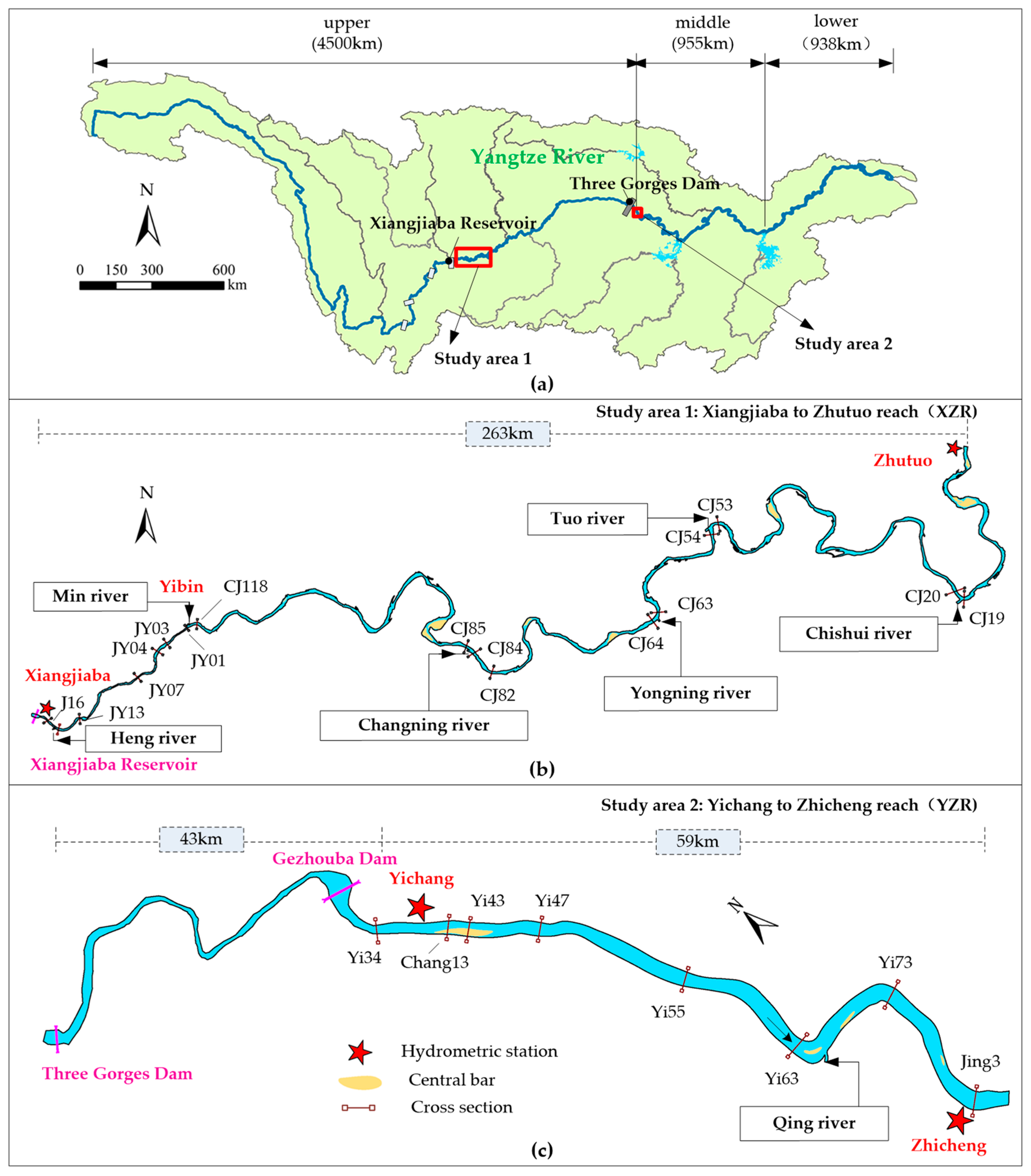
The Yangtze River, originating from the Qinghai–Tibetan Plateau, flows into the East China Sea and is traditionally divided into upper, middle, and lower reaches (Figure 1a). The upper reaches, stretching from Yushu to Yibin and known as the Jinsha River, are heavily impounded by dams with a cumulative storage capacity of 90.7 km3 [40]. A series of hydropower stations have been constructed, including Wudongde, Baihetan, Xiluodu, and Xiangjiaba, in the lower reaches of the Jinsha River. The XZR is situated immediately downstream of the Xiangjiaba reservoir (Figure 1b), covering the region between the Xiangjiaba and Zhutuo hydrologic stations, with a length of about 263 km. It is joined by three large tributaries, namely the Heng River, the Min River and the Tuo River. Additionally, other tributaries such as the Yongning River and the Chishui River also experience considerable increases in sediment loads during intense rainstorm floods.
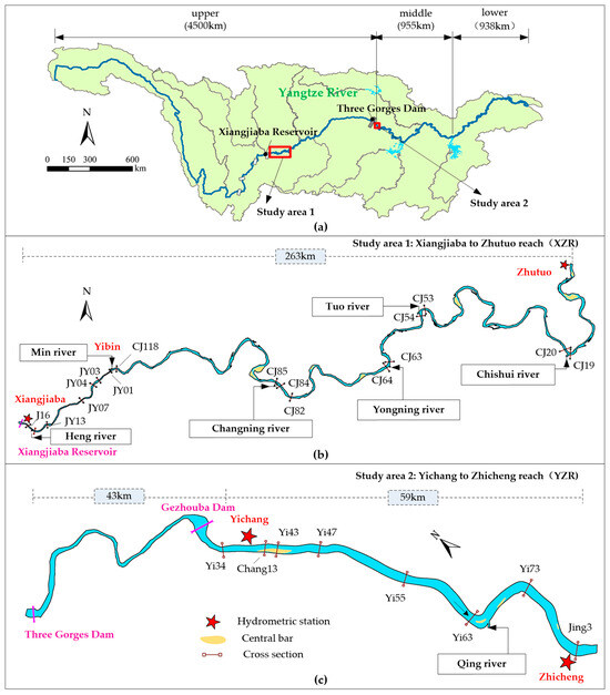
Figure 1.
The geographical location of the study areas. (a) Yangtze River Basin; (b) Xiangjiaba to Zhutuo reach (XZR); (c) Yichang to Zhicheng reach (YZR).
After passing through the Three Gorges, the Yangtze River transitions from a mountainous to a plain river. The YZR is positioned 43 km downstream of the Three Gorges Dam (TGD), which covers the region between the Yichang and Zhicheng hydrologic stations, with a length of about 59 km (Figure 1c). The planar morphology is generally straight and slightly curved, and the Qing River joins from the south.
Similarly, both the XZR and the YZR are located immediately downstream of their respective reservoirs and feature gravel–sand riverbeds. Hills and terraces flank the two reaches, and the riverbanks exhibit strong resistance to erosion. Influenced by upstream damming, both reaches have experienced significant riverbed adjustments. Comparatively, the XZR is situated in a mountainous gorge region where tributaries transport substantial sediment loads during heavy rain and flood events. In contrast, the YZR serves as a transitional section from mountainous to alluvial plain rivers, typically characterized by a wide valley with a straight and slightly meandering river pattern, and its tributaries have a relatively low sediment concentration.
2.2. Data
To investigate the variations in channel geometry at the reach scale for the XZR and YZR following dam construction, a comprehensive set of observational data, encompassing hydrological and topographic information, has been assembled (Table 1).

Table 1.
Details of the data.
The hydrological data, which include the daily flow discharge and suspended sediment concentration at four hydrometric stations named Xiangjiaba (Pingshan), Zhutuo, Yichang, and Zhicheng were provided by the Changjiang Water Resources Commission (CWRC). The Xiangjiaba and Zhutuo hydrometric stations represent the in/out flow and sediment dynamics of the XZR. Notably, the Xiangjiaba station was established in 2008, and the Pingshan station characterized the flow and sediment conditions of the lower reaches of the Jinsha River before damming. Also, the hydrological data of Yichang and Zhicheng stations reflect the altered flow–sediment regimes in the YZR. Sediment measurements in the Yangtze River are carried out in compliance with the river’s discharge and sediment measurement specifications. During the measurement process, a single sediment–discharge relationship is commonly employed. The potential sources of error encompass instrument inaccuracies, errors in water sample processing, and sampling inaccuracies. For first-class and second-class stations, the systematic errors in sediment discharge measurements at hydrological stations are estimated to be 3.0% and 4.5%, respectively. The precision of sediment discharge measurements at these stations is relatively high, and the relative error in these measurements remains stable, fulfilling the necessary criteria for analyzing sediment transport dynamics within the river systems.
Additionally, two types of topographic datasets have been sourced from the CWRC, including the cross-sectional profiles measured in the post-flood period and the bathymetric map comprising the measured elevation points. Post-flood cross-sectional profiles of the XZR and YZR are also collected from the CWRC. In total, 185 specified cross sections, 135 in the XZR and 50 in the YZR, have been measured by the CWRC in the post-flood period each year after damming. However, in 2016, cross-sectional measurement was not conducted in the reach from Yibin to Zhutuo. Consequently, cross-sectional data were obtained from bathymetric map data. The methodology for cross-sectional topography employed in this study involves plotting cross-sections on a 1:5000 scale topographic map, capturing points along the cross-section line at the intersection of contour lines, and ensuring that the cross-sectional data are in accordance with the topographic map. This approach minimizes the error associated with cross-sectional extraction. Furthermore, the accuracy of the erosion and deposition volume calculations performed using the cross-sectional data depends on the precision of the channel capacity. The primary sources of error in these calculations are the representativeness of the cross sections and the accuracy of elevation measurements. The measured cross-sections are strategically distributed to ensure that the calculation of bed deformation is relatively accurate [41,42]. The spacing between consecutive cross sections varies from 0.36 to 3.55 km, with an average distance of about 2.0 km in the XZR and 1.2 km in the YZR. The density of cross-section placement complies with the specifications.
2.3. Methods
2.3.1. Calculation of Bankfull Channel Erosion and Deposition Amounts
In this study, 135 measured cross-sections in the XZR and 50 in the YZR were utilized to calculate the erosion and deposition amounts. The morphology of the cross-sections and the relationship between water levels and discharge was used to determine the bankfull channel. According to the CWRC report, the bankfull channels downstream of the Xiangjiaba reservoirs correspond to flow discharge rates of 30,000 m3/s at the Zhutuo hydrologic station. Similarly, for the middle reaches of the Yangtze River, including YZR, the bankfull channels correspond to discharge rates of 30,000 m3/s at the Yichang hydrologic station [43]. Considering the good continuity of the measured cross-sections on the spatial scale, the channel capacity for a specific year can be calculated as follows:
where V represents the bankfull channel capacity; N is the total number of cross sections; Ai represents the area of the i-th cross section; and Di denotes the distance from the i-th section to the subsequent (i + 1)-th section.
Then, based on the variation in channel capacity between successive measurements, the annual amount of erosion and deposition can be calculated as follows:
where represents the channel erosion and deposition amount in j-th year. However, > 0 reflects the erosion of the riverbed, and if < 0, the riverbed is silted up.
2.3.2. Calculation of Reach-Scale Channel Morphology
To reflect the overall geometric characteristics of the entire reach, this study adopts the reach-averaged approach proposed by Xia et al. [44]. This method integrates a geometric mean derived from logarithmic transformation with a weighted average that accounts for the distance between adjacent sections. Consequently, the morphological parameters for the bankfull channel at the reach scale can be expressed as follows:
The bankfull morphology of the i-th section () is characterized by its width (), depth (), and cross-sectional area (). Here, di+1 refers to the distance between the i-th and the subsequent (i + 1)-th sections. The total number of sections within the specified reach is denoted by N, and L represents the length of the reach.
3. Results
3.1. Variations in Cross-Sectional Morphology
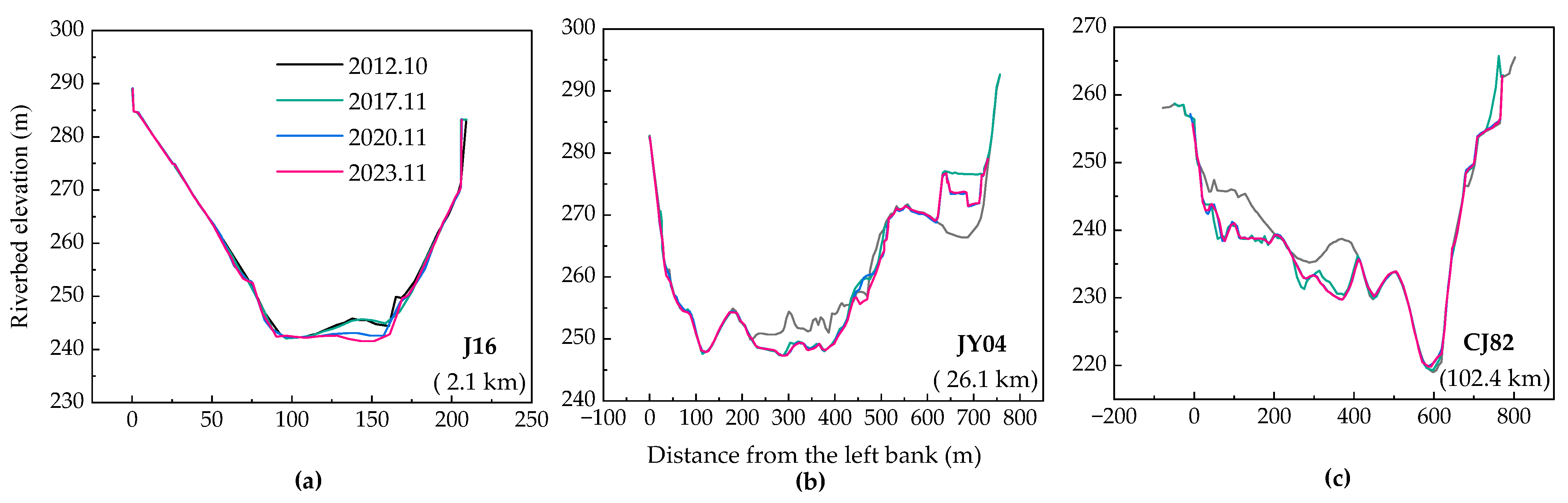
The cross-sectional morphology in XZR, immediately downstream of the XJB, predominantly exhibits “U” and “V” shapes. Influenced by the altered flow–sediment regimes, the complicated riverbed boundary conditions and human activities, significant sectional deformations are primarily observed in the main channel and bars. For example, the section J16 located near the Xiangjiaba hydrological station occupies a riverbed composed of gravel, sand and rock. The concrete revetment on the left bank and the concrete fortress on the right bank make both sides relatively stable, with a scouring depth of nearly 3 m occurring in the main channel since the impoundment of XJB (Figure 2a). Additionally, the right bank of the section JY04 located 26.1 km downstream of the dam has been engineered to advance into the river, with a maximum elevation increase of 7.4 m (Figure 2b). And the main channel has experienced degradation by a maximum of 6 m during the post-dam period. Furthermore, section CJ82, 102.4 km downstream of the dam, is selected as an example of the meandering river pattern. The riverbed deformation is characterized by the erosion of the convex bank, with a maximum erosion depth of 8m (Figure 2c). In summary, intensive channel adjustments have occurred in the XZR following the construction of the dam. However, human activities primarily lead to sudden changes in the riverbank or fluvial channel morphology, and a significant reduction in sediment load has resulted in severe channel erosion, predominantly during the initial impoundment period.
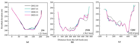
Figure 2.
Changes in the bed profiles at typical cross-sections in the XZR immediately downstream of the XJB. (a) J16; (b) JY04; (c) CJ82.
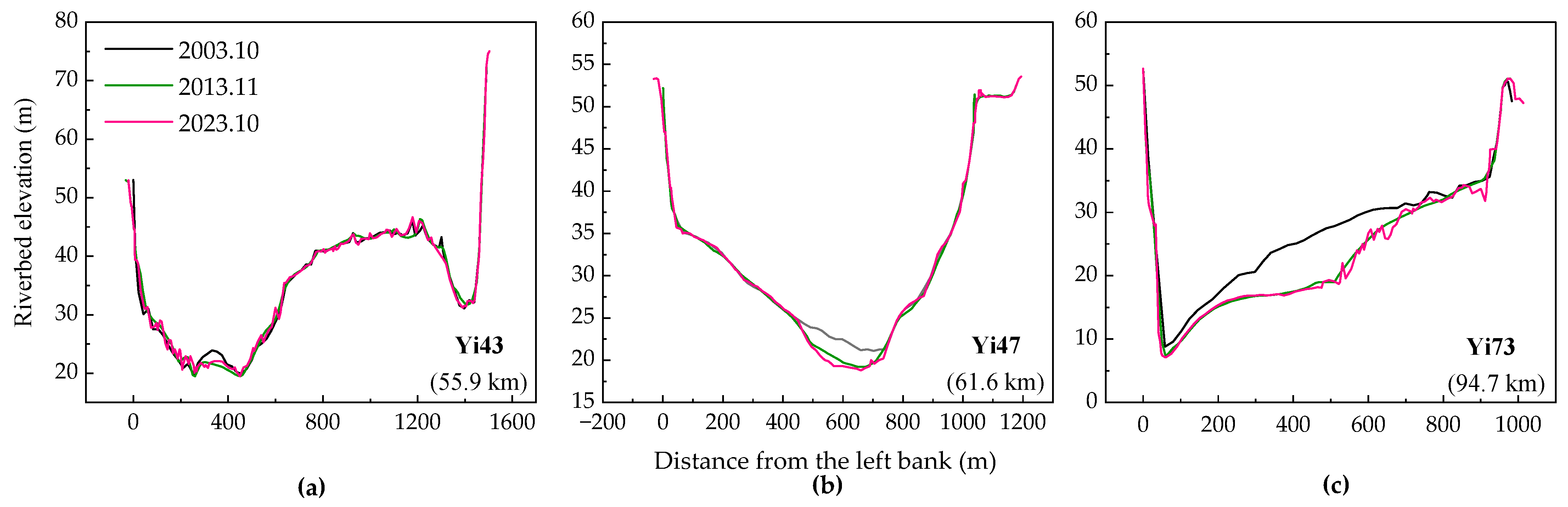
In comparison, the cross sections in the YZR are mainly characterized by longitudinal scouring, with minimal transverse deformation due to the strong scour resistance of the riverbanks. For example, section Yi43 is located in the braided channel, with the right branch relatively stable and the left branch experiencing erosion (Figure 3a). Section Yi47, located in the straight channel, experienced degradation in the initial years following the TGD impoundment (Figure 3b). However, between 2014 and 2023, little erosion or deposition has occurred. Section Yi73, located in a curved channel, has mainly experienced the incision of the convex bank (Figure 3c). It is evident that the adjustment of channel erosion predominantly occurred in the early stage of the TGD impoundment as well.
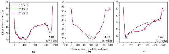
Figure 3.
Changes in the bed profiles at typical cross-sections in YZR immediately downstream of the TGD. (a) Yi43; (b) Yi47; (c) Yi73.
3.2. Longitudinal Variation in Reach-Scale Bankfull Channel Geometry
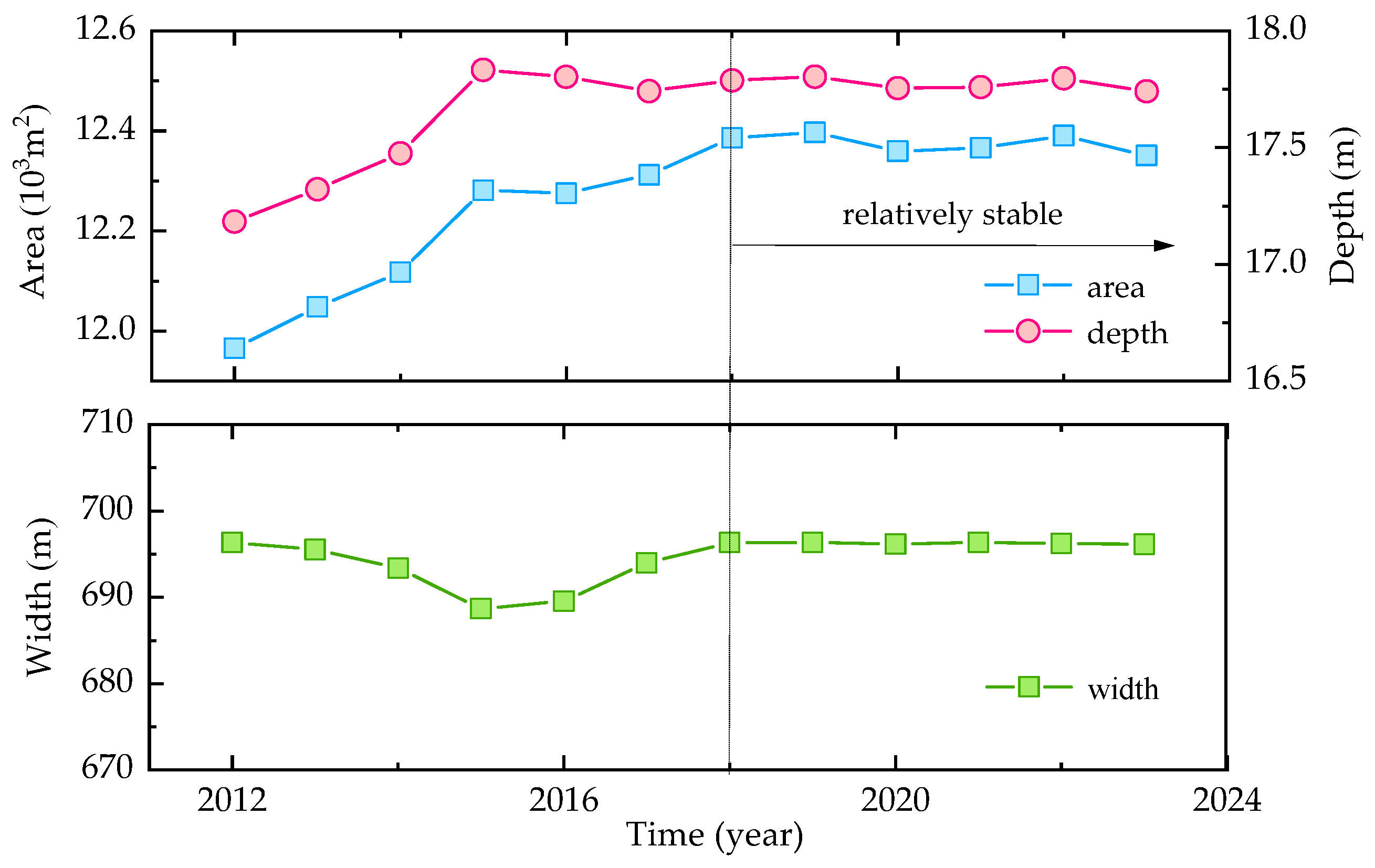
This study calculated the reach-scale channel dimensions to illustrate the temporal variations following dam construction. The results indicate a significant increase in the area and depth of the bankfull channel dimensions, with minimal changes in width for the two studied reaches located immediately downstream of the XJB and TGD.
As for the XZR located immediately downstream of the XJB, the depth increased from 17.18 m in 2012 to 17.74 m in 2023, while the area expanded from 11.97 × 10³ m2 to 12.35 × 10³ m2, with an increase of 3% (Figure 4). During the early stage of XJB impoundment, the bankfull channel geometry, encompassing both depth and area, presented a significant increase during the first 6 years after damming, and remained relatively stable afterwards. However, there were some slight fluctuations between the years due to the flow and sediment dynamics during the relatively stable period. For example, compared with 2019, the bankfull area experienced a decrease of approximately 0.3% in 2020. Nonetheless, the reach-scale morphological parameters recovered during the following two years.
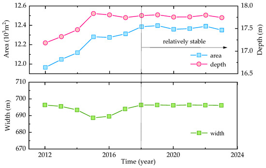
Figure 4.
Temporal variations in the reach-scale bankfull channel dimensions of the XZR immediately downstream of the XJB.
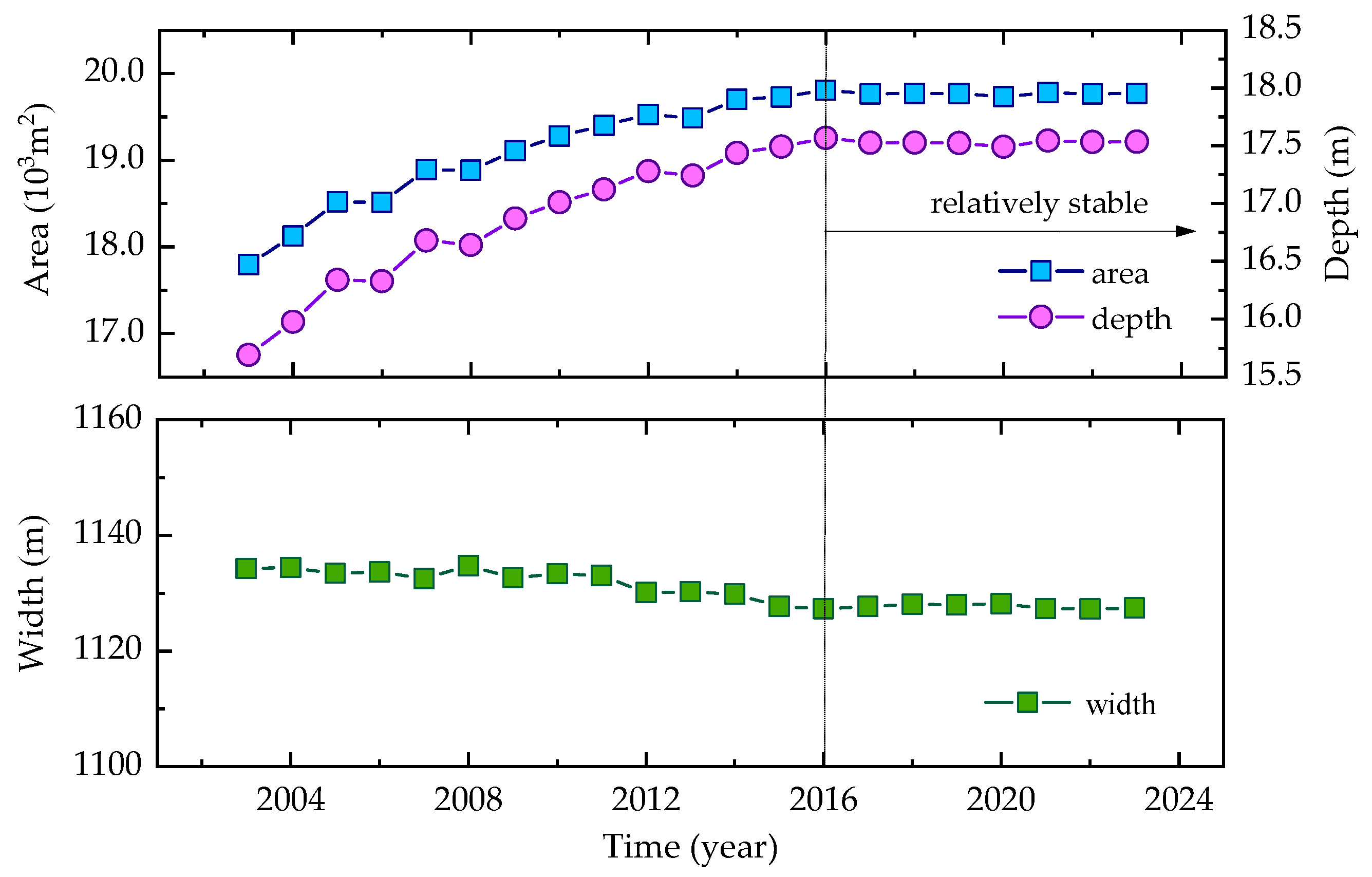
After the construction of the TGD, the YZR has undergone significant channel adjustment as well. Specifically, the bankfull area expanded from 17.80 × 10³ m2 in 2003 to 19.77 × 10³ m2 in 2023, representing an 11.1% increase. Additionally, the bankfull depth increased by 11.7%, while the width decreased by less than 1% (Figure 5). During the first 13 years of the TGD impoundment, the reach-scale bankfull cross-sectional depth and area increased by about 11.3% and 12.0%, respectively. Considering the rapid coarsening of bed material, then the hydraulic geometry parameters of the bankfull channel changed little and have tended to stabilize. Even when encountering the basin flood in 2020, there was no significant increase in the bankfull area or depth.
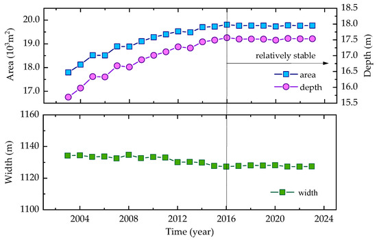
Figure 5.
Temporal variations in the reach-scale bankfull channel dimensions of the YZR immediately downstream of the TGD.
Compared to the temporal variations in the reach-scale bankfull channel morphology of the two studied reaches, it is evident that in the initial stage of the dam impoundment, the bankfull channel depth and area showed significant increases, and the strong anti-scourability of the riverbanks has limited transverse deformation. It takes 6 to 13 years for the two gravel–sand riverbeds to reach new equilibria with the coarsening process of the bed material. However, there seem to be some fluctuations in the riverbed morphology of the XZR, while the reach-scale channel dimensions of the YZR are more stable after reaching a relative equilibrium states.
3.3. Amount of Erosion and Deposition After Damming
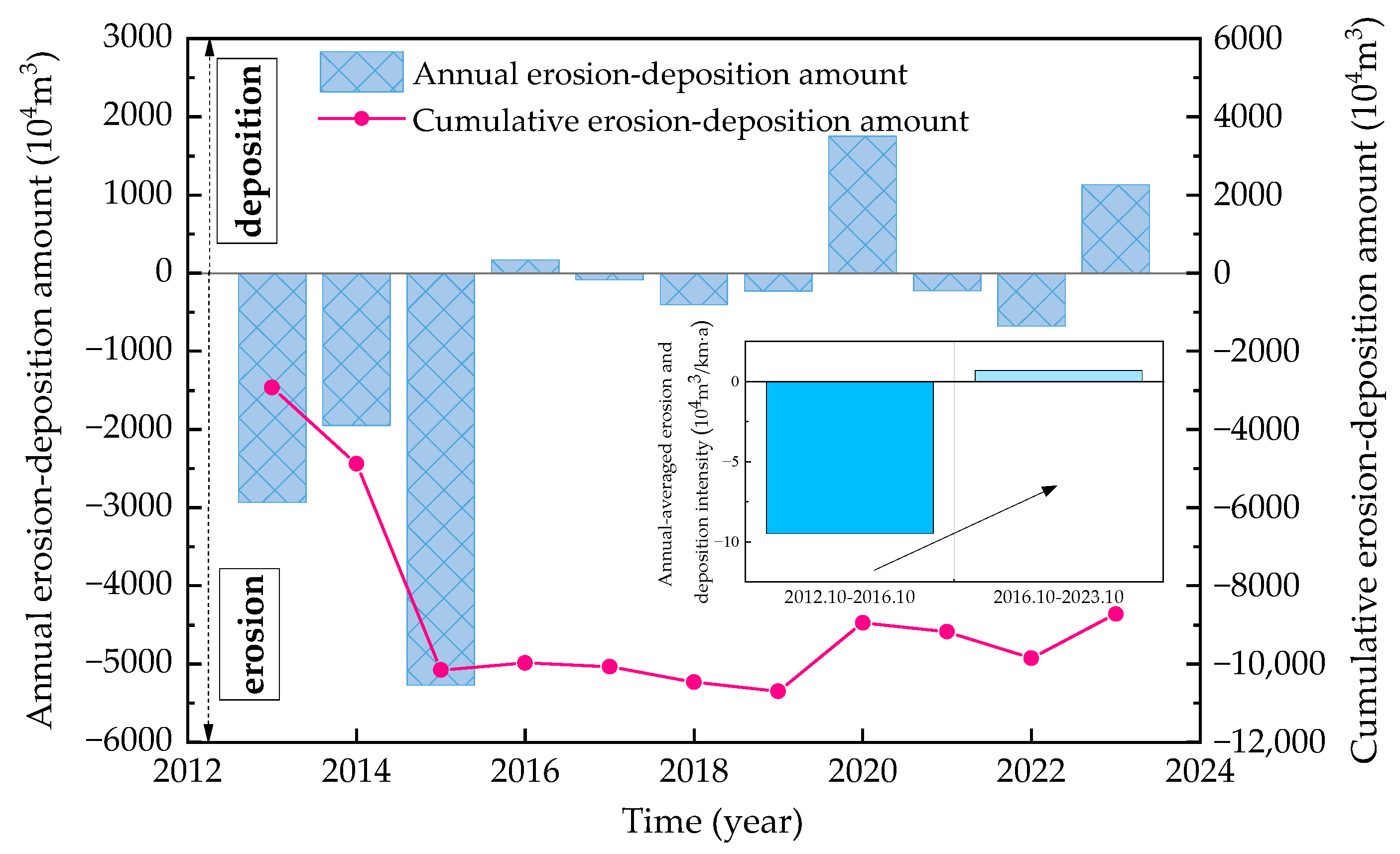
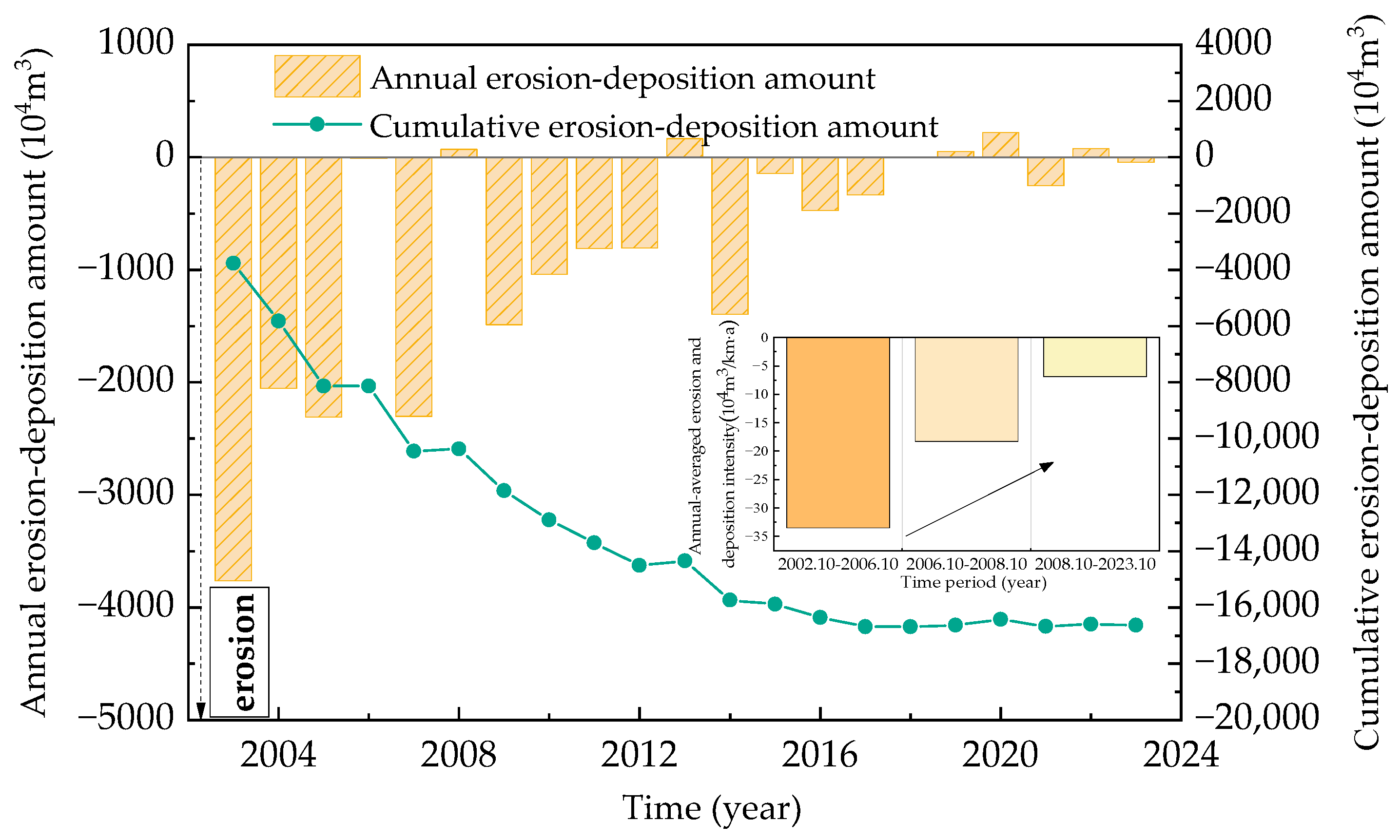
The progressive construction and joint operation of the cascade hydropower stations on the main stem of the Jinsha River, including Xiangjiaba, Xiluodu, Wudongde, and Baihetan, have exerted profound influences on both reservoir sedimentation and downstream erosion. After the impoundment of XJB in 2012, a total of 8718 × 104 m3 sediment scouring (including the amount of sand excavation) has occurred in XZR (Figure 6).

Figure 6.
Annual and cumulative amount of channel erosion and deposition in XZR.
From a temporal perspective, erosion predominantly occurred in the initial stage of the Xiangjiaba Reservoir’s operation. The cumulative scouring amount from 2012 to 2016 was approximately 9979 × 104 m3, with an average annual erosion intensity of 8.8 × 10⁴ m3/km for the river sections from Xiangjiaba to Yibin and 9.6 × 10⁴ m3/km from Yibin to Zhutuo. Since 2017, with the implementation of regulations prohibiting sand excavation and the sharp decrease in washable sediment on the riverbed downstream of the dam, the erosion intensity of XZR has significantly decreased and the cumulative erosion amount has not shown a trend of growth. Notably, in certain years, significant sedimentation occurred immediately downstream of the dam. In 2020, 1751 × 104 m3 of sediment was deposited in the mainstem of XZR for the first time after damming. However, continued scouring was observed in the subsequent two years, with a cumulative scour of 904 × 104 m3, indicating a considerable amount of erosion compared with the deposition amount in 2020. Similarly, 1132 × 104 m3 of sediment was deposited again in 2023. Thus, the average annual deposition intensity of XZR was 0.69 × 10⁴ m3/km from 2016 to 2023.
In summary, due to multiple factors, including the substantial decrease in sediment discharge and sand excavation, the XZR immediately downstream of the dam presented a state of erosion, with an average annual erosion intensity of about 9.5 × 10⁴ m3/km from 2012 to 2016. However, there has been no further increase in the cumulative erosion since 2017. In certain years, the cumulative erosion amount actually decreased as a result of channel sedimentation, followed by periods of erosion that ultimately led to a state of relative equilibrium.
In comparison, the YZR located immediately downstream of the TGD has experienced a total sediment erosion of 1.664 × 10⁸ m3, with an average annual erosion of 0.079 × 10⁸ m3 per year from 2003 to 2023 (Figure 7). During the initial impoundment of the TGD (2003 to 2006), the amount of scoured sediment from YZR was 0.814 × 10⁸ m3, accounting for 49% of the total erosion since impoundment, with an average annual erosion intensity of 34.5 × 10⁴ m3/km. Between 2007 to 2008, the cumulative scouring amount was 0.223 × 10⁸ m3, averaging an annual erosion intensity of 18.9×10⁴ m3/km. However, due to the 175 m experimental storage level of the TGD, the erosion intensity in the YZR has further weakened. From 2009 to 2023, the average annual erosion intensity of the YZR was 7.1 × 10⁴ m3/km per year.
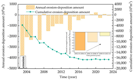
Figure 7.
Annual and cumulative amount of channel erosion and deposition in YZR.
It can be seen that, as the years that the TGD is in operation increase, the erosion intensity of the YZR immediately downstream of the dam gradually weaken. Since 2016, the cumulative amount of riverbed erosion has substantially approached a constant value, with little variation during the years.
In comparison, there are some similarities and dissimilarities in the morphodynamic impacts downstream of the XJB and the TGD. Initially, both the XZR and the YZR experienced a high erosion intensity in response to damming. Then, as the years of the dams’ impoundment have increased, the processes of bed material coarsening have weakened the post-scouring intensity, and the gravel–sand riverbeds require a response time of 6 to 13 years to reach new equilibrium. However, in certain years after reaching equilibrium, the XZR has undergone significant sedimentation, and a considerable amount of erosion occurred. In contrast, the YZR downstream of the TGD has remained in a relatively stable state, with little erosion or deposition occurring.
4. Discussion
Following the impoundment of large reservoirs, downstream riverbed adjustment is a complex, long-term process. Numerous factors influence the fluvial responses in the downstream reaches, primarily including flow–sediment dynamics, riverbed boundaries, and human activities.
4.1. Channel Adjustments Response to the Flow and Sediment Conditions
Downstream reaches generally experience erosion and deposition adjustments in response to the altered flow–sediment dynamics following dam construction, a phenomenon commonly observed in large rivers [45,46,47,48].
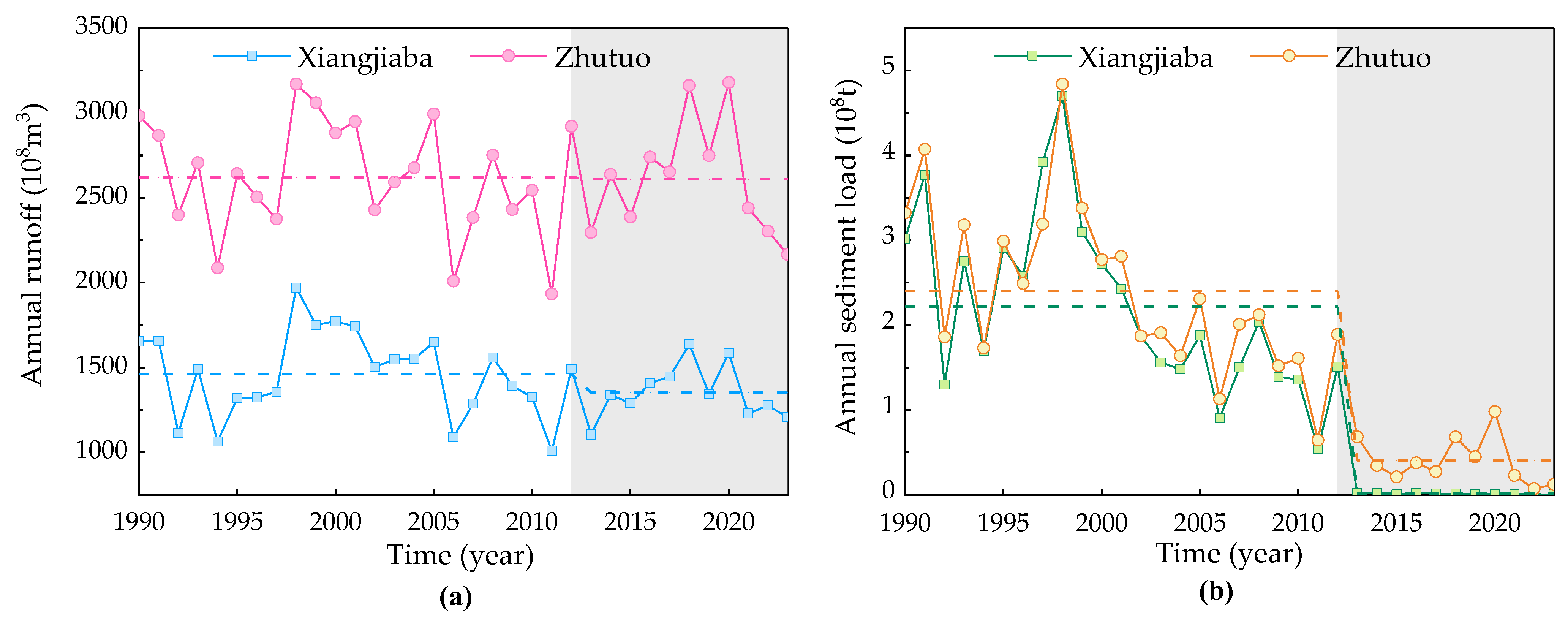
After the construction of the XJB in the lower reaches of Jinsha River, the average annual runoff at the Xiangjiaba Station was 1352 × 108 m3, representing only a 7.5% reduction compared to the pre-dam period (Figure 8). Considering the confluence of multiple tributaries, the average annual runoff at the Zhutuo station that reflected the outlet of the XZR was 2610 × 108 m3. According to the water balance principle, the total annual runoff from the tributaries in this reach is estimated to be 1300 × 108 m3, which is close to the runoff at the Xiangjiaba station. However, the sediment transport at the two stations has exhibited a prominent decrease compared to the annual runoff. This reduction is attributed to the sediment trapping in upstream cascade reservoirs. The average annual sediment load at the Xiangjiaba station and Zhutuo station dropped to 134 × 104 t and 4030 × 104 t after damming, respectively. In comparison, due to the effects of riverbed scouring and the input of sediment from tributaries along the river, the sediment load reduction at the Zhutuo Station was 83.2%, which is less pronounced than the 99.4% reduction observed at the Xiangjiaba Station. Consequently, the inflowing tributaries significantly contribute to the flow–sediment conditions of the XZR.
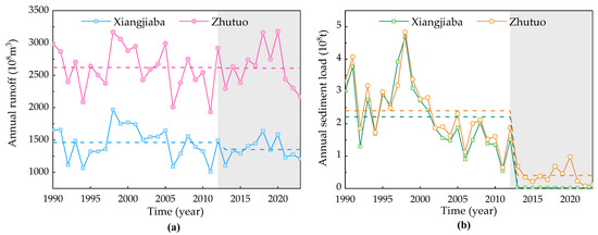
Figure 8.
Temporal variations in annual runoff and sediment load at hydrological stations in the XZR. (a) Annual runoff; (b) Sediment load.
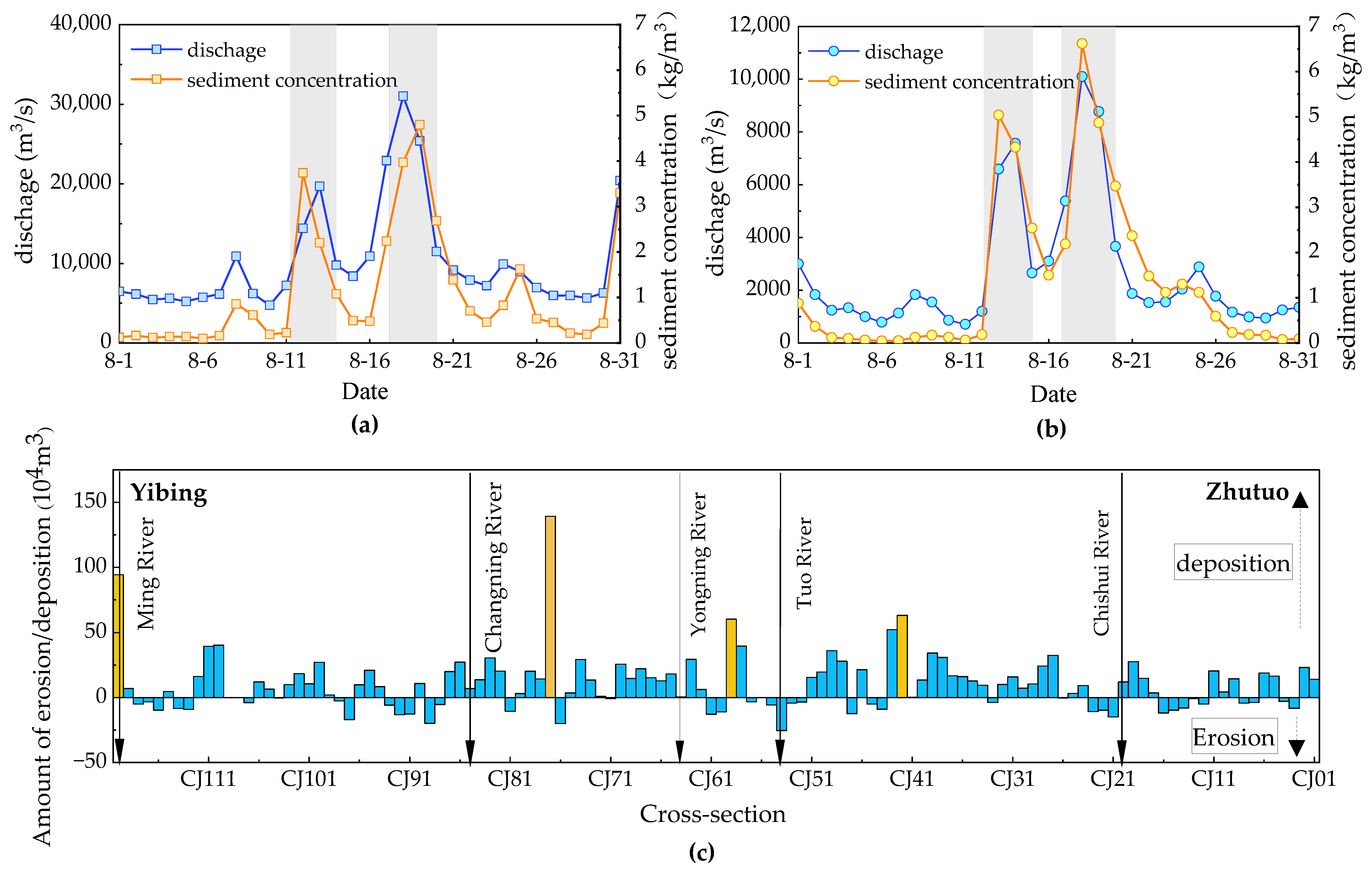
The proportion of annual runoff from the three major tributaries, named the Heng River, Min River and Tuo River, accounted for 40% after the operation of the XJB, with a small increase of 2% compared to the pre-dam period. However, the combined average annual sediment load of these tributaries is a staggering 25 times that of the Xiangjiaba station. Their contribution to the sediment transport at the Zhutuo station increased from 20% to 82% after damming. Generally, mountain rivers possess the capacity to carry high-intensity sediment yields during intense rainfalls and floods [49,50]. The observational data reveal that the inflow from tributaries supplies the sediment sources for substantial downstream deposition in certain years, such as 2020 and 2023. In August 2020, the primary sediment-producing areas within the Min and Tuo river basins experienced consecutive rainfalls that were notable for their concentration, intensity, and extensive coverage. The annual sediment transport of these two tributaries reached 6630 × 104 t and 2100 × 104 t, showing increases of 238% and 144%, respectively, compared to the post-dam annual averages (Figure 9a,b). Other tributaries, such as the Chishui River, also experienced significant floods, transporting substantial amounts of sediment into the reaches downstream of the XJB [39]. From April to October, the cross-sections with considerable deposition were located immediately downstream of the confluences of the Min, Changning, Yongning, and Tuo rivers (Figure 9c).
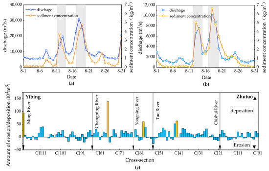
Figure 9.
Flow and sediment conditions of tributaries in August 2020. (a) Discharge and sediment concentration at Gaochang station on the Ming River; (b) Discharge and sediment concentration at Fusun station on the Tuo River; (c) Channel erosion and deposition amount along the reaches from Yibin to Zhutuo (April 2020–October 2020).
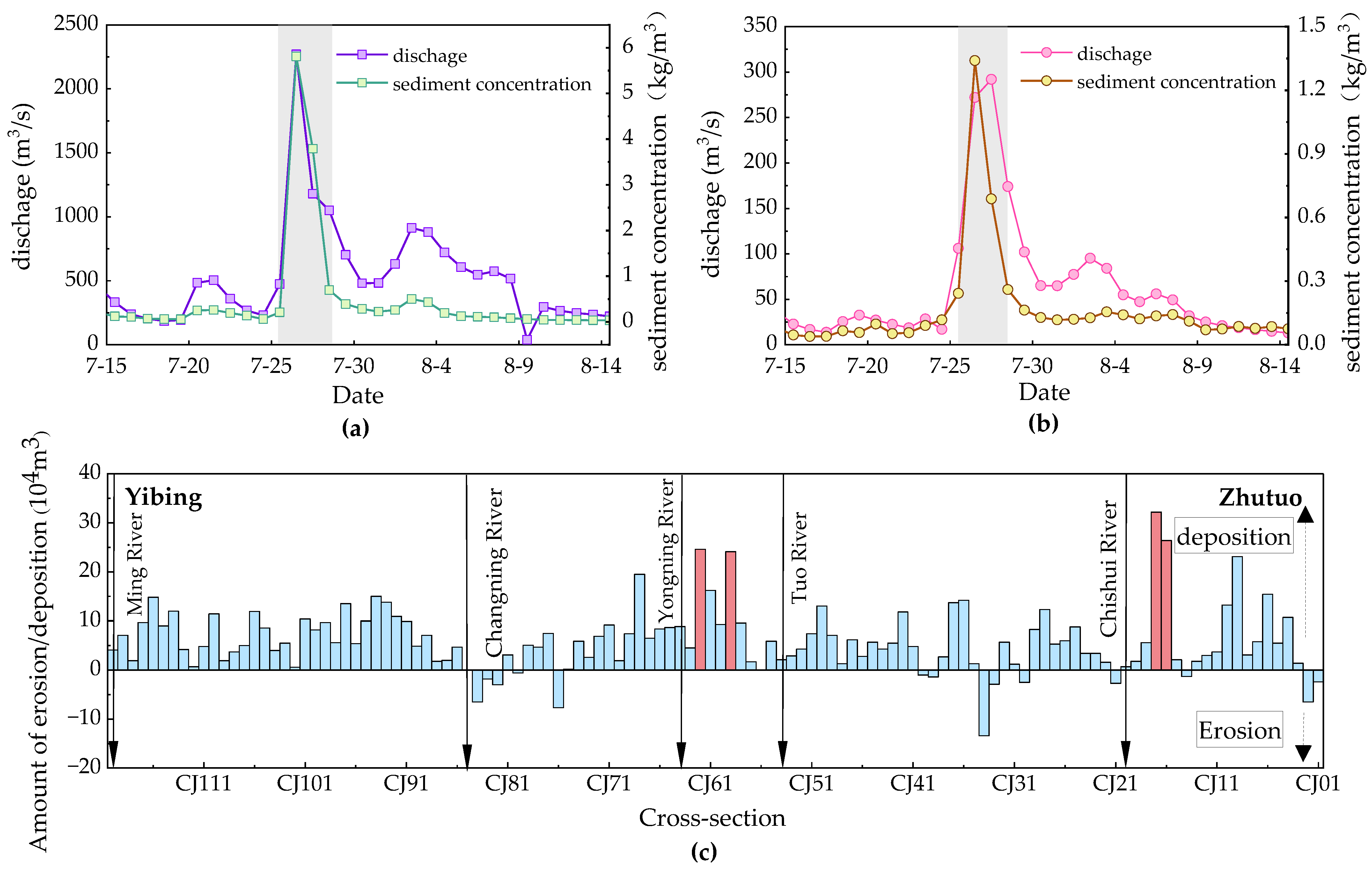
Also, in 2023, the Chishui River was hit by a flood event on July 27, which had an average sediment concentration of 5.81 kg/m3 and led to a daily sediment load of 114 × 104 t. The recorded peak discharge and sediment concentration reached 4380 m3/s and 14.2 kg/m3, respectively (Figure 10a). On the same day, the Yongning River also encountered a large flood, with a maximum discharge of 727 m3/s and a sediment concentration of 4.21 kg/m3, leading to a daily sediment load of 3 × 10⁴ t (Figure 10b). The intense sediment production and transport during these floods in the Chishui and Yongning rivers served as substantial sources for sediment deposition downstream of the XJB (Figure 10c). Channel adjustments during the flood season further indicated that the cross-sections from Yibin to Zhutuo are predominantly characterized by deposition, particularly in the wide valley sections downstream of the confluences of the Yongning and Chishui rivers.
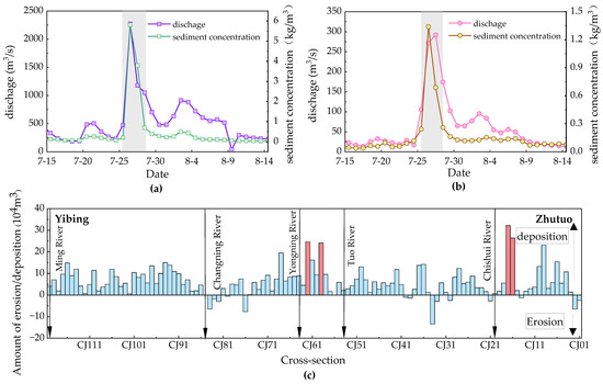
Figure 10.
Flow and sediment conditions of tributaries in July/August 2023. (a) Discharge and sediment concentration at Chishui station on the Chishui River; (b) Discharge and sediment concentration at Xuyong station on the Yongning River; (c) Channel erosion and deposition amount along the reaches from Yibin to Zhutuo (April 2023–October 2023).
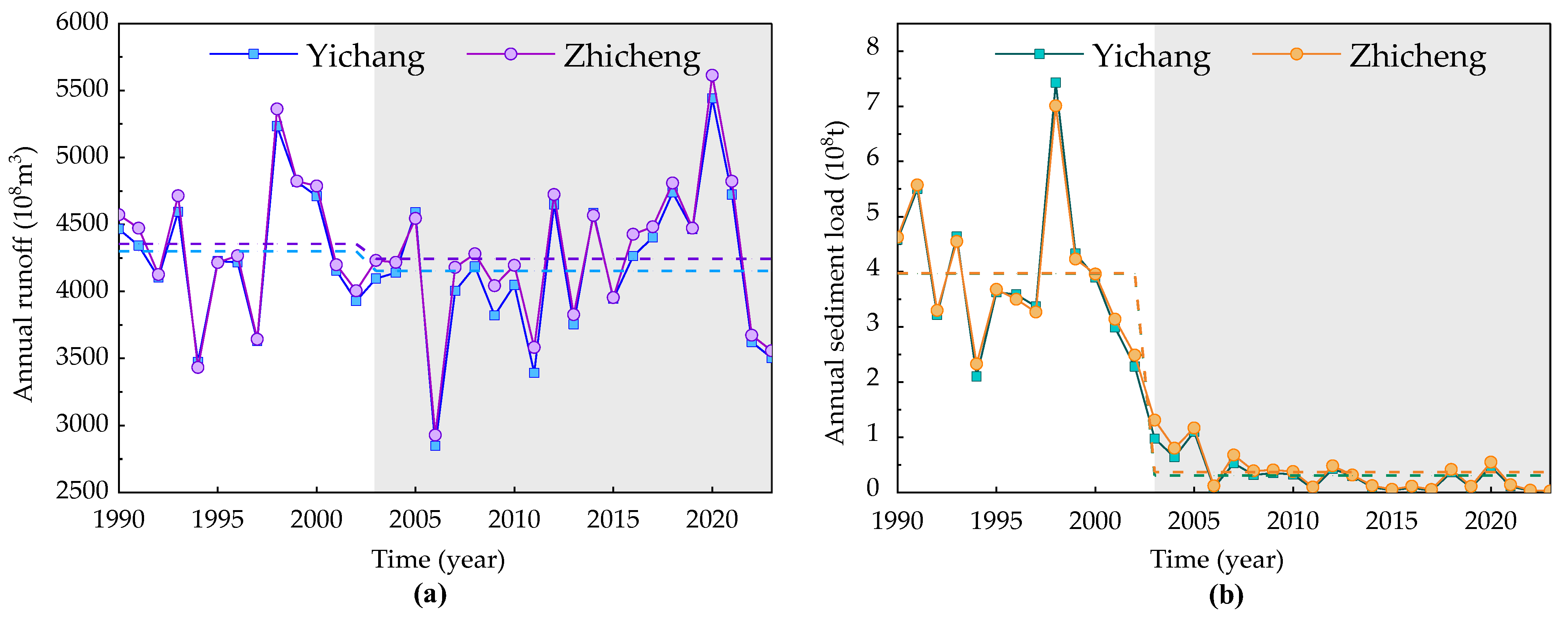
In comparison, for the YZR immediately downstream of the TGD, the average annual runoff at the Yichang and Zhicheng stations was 4150 × 108 m3 and 4250 × 108 m3, respectively, after damming, with a relatively small reduction of less than 3% (Figure 11a,b). It can be calculated that the tributary inflows between Yichang and Zhicheng contribute only about 2% to the annual runoff at the Zhicheng Station. However, the average annual sediment transport at the Yichang and Zhicheng stations was 3070 × 104 t and 3710 × 104 t after the TGD impoundment, showing a significant decrease of more than 90% compared with the pre-dam period. The sediment supply from Yichang to Zhicheng primarily originates from the riverbed scouring, considering the low sediment concentration in the tributary of the Qing River.
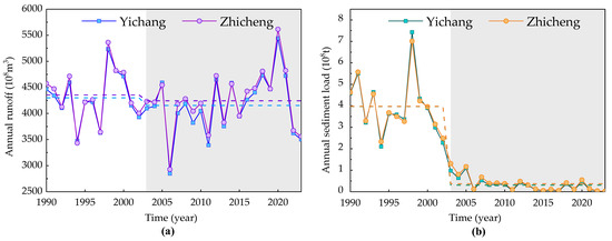
Figure 11.
Temporal variations in annual runoff and sediment load at hydrological stations in the YZR. (a) Annual runoff; (b) Sediment load.
From the perspective of incoming flow and sediment dynamics, there are many tributaries in the XZR and the majority of them experience intense erosion due to gravitational and hydrological forces. During flood events, these tributaries transport substantial and concentrated sediment loads, which subsequently become the predominant sources of sediment deposition in the downstream reaches following dam construction. In contrast, the tributary inflows of the Qing River, characterized by a low sediment concentration, have little impact on the riverbed evolution of the YZR downstream of the TGD.
4.2. Effects of Riverbed Boundary Conditions on Channel Adjustments
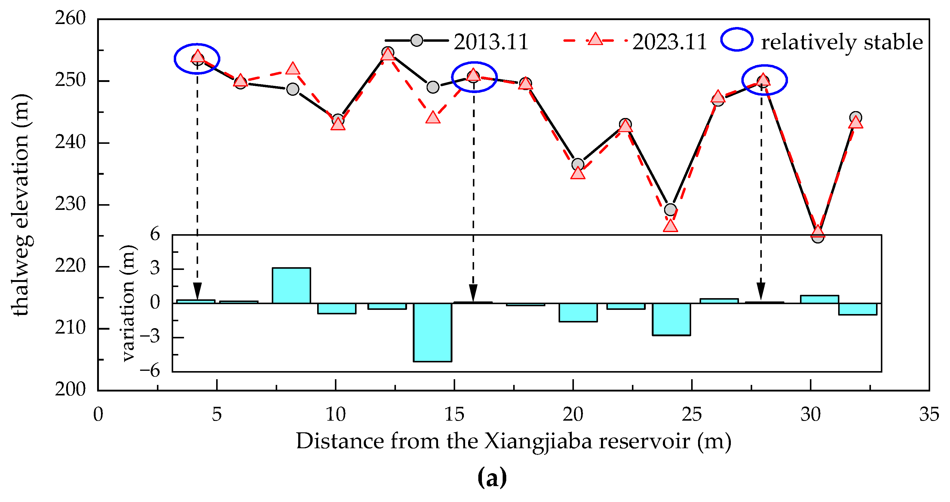
Riverbed boundary conditions also play a crucial role in influencing channel erosion and deposition adjustments. The XZR and YZR, situated immediately downstream of the dam, have both undergone significant erosion due to changes in flow duration and sediment deficiency. However, the high resistance provided by hills, levees, and bank protection works has constrained the lateral deformation of the riverbed. As a result, the adjustments in erosion and deposition have primarily manifested as vertical incision, with varying degrees of thalweg cutting down along the reach. The changes in the longitudinal thalweg indicate that certain cross-sections have remained relatively stable, with little erosion. These cross-sections effectively control the channel boundaries in both the XZR and YZR downstream of the dams (Figure 12).
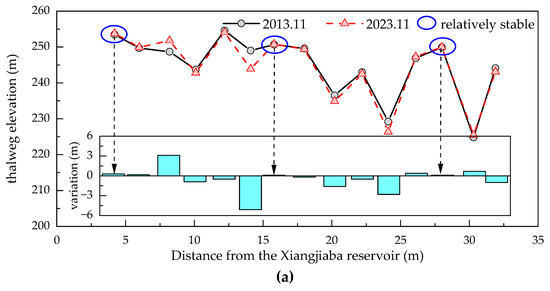

Figure 12.
Variations in thalweg elevations. (a) The reaches immediately downstream of the XJB; (b) The reaches immediately downstream of the TGD.
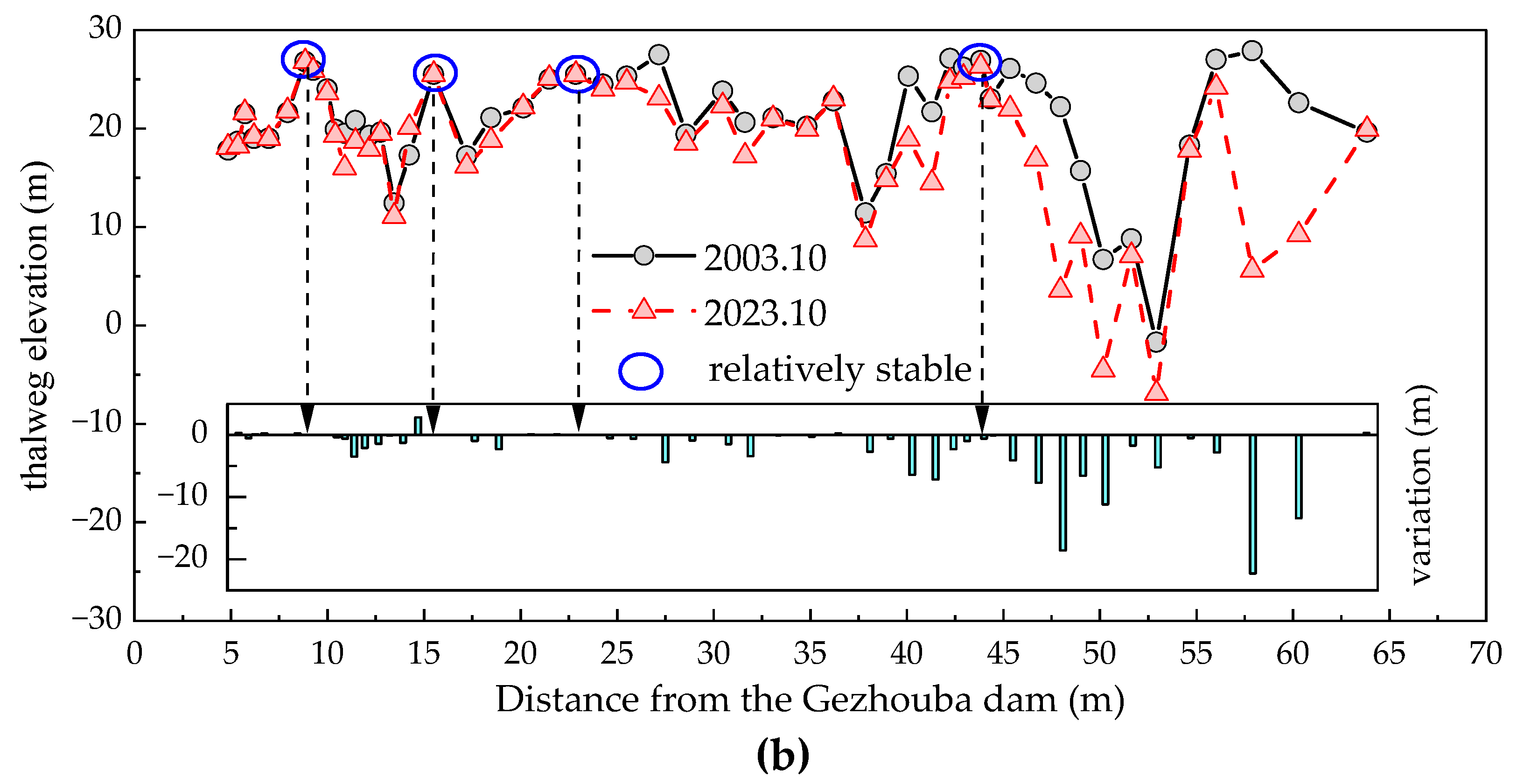
The riverbed downstream of the dam has also undergone a significant coarsening process due to the deficiency in sediment transport. Fifteen bed material samples immediately downstream of the XJB indicated that the median diameters (D50) of the particles in three cross-sections were less than 1 mm during the initial impoundment in 2013. However, by the end of the post-flood period in 2023, the smallest D50 among the 15 measured cross-sections had increased to 39.3 mm, indicating a transition from a sand–gravel riverbed to a predominantly gravel bed. For example, at the JY01 cross section, located 31.9 km downstream of the dam, the proportion of riverbed particles smaller than 1 mm decreased from 98.7% to 72.4% over the five years following damming (Figure 13a). However, no particles smaller than 32 mm were detected on the riverbed of the mentioned cross-section in 2023, and the D50 had increased to 110 mm (Figure 13b). This demonstrates that the degree of bed material coarsening downstream of the XJB is substantial, with a notable reduction in washable sediment on the riverbed.
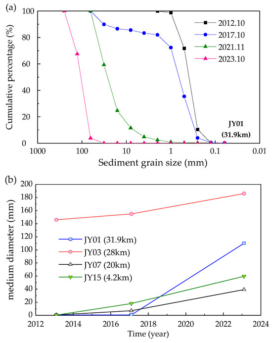
Figure 13.
Changes in bed materials at typical cross-sections in the XZR. (a) Bed material gradations at JY01; (b) Temporal variations in the median particle size (D50).
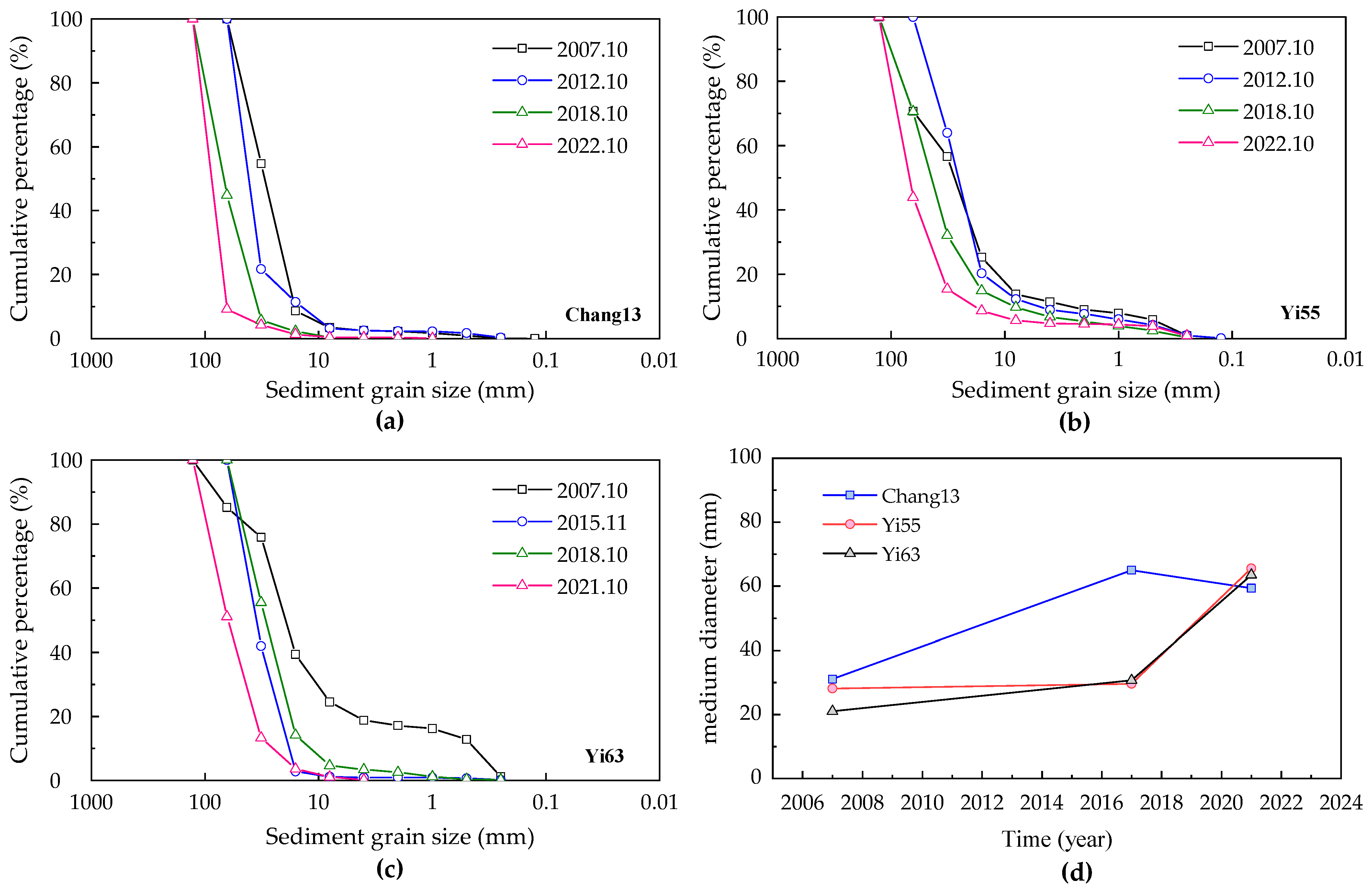
Similarly, the reaches immediately downstream of the TGD have also undergone bed material coarsening after damming [37]. For example, the median diameters (D50) of the particles at three representative cross-sections (Chang13, Yi55, and Yi63) ranged between 28.1 × 10⁻³ and 31.1 × 10⁻³ m in 2007. However, the D50 values had more than doubled by 2021, ranging between 59.4 × 10⁻³ and 65.5 × 10⁻³ m (Figure 14). At the cross-section Chang13, the maximum sampled grain size was 44.5 mm and the proportion of sediment with particles smaller than 32 mm was 54.7% in 2007. By 2022, sediments with grain sizes between 64 mm and 128 mm had become dominant, accounting for 90.8% of the riverbed composition. Additionally, the coarsening of the bed material has inhibited further erosion, with the sediment replenishment from the riverbed progressively going downstream. The average annual erosion of sediment with particles larger than 0.125 mm from Yichang to Shashi was 2125 × 104 t in 2003–2008, fairly evenly distributed between the reaches of Yichang to Zhicheng and Zhicheng to Shashi. However, the average annual sediment replenishment (d > 0.125 mm) decreased to 672 × 104 t in 2009–2023, with a distribution ratio of 1:9 between the two reaches.
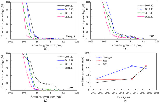
Figure 14.
Changes in bed materials at typical cross-sections in the YZR. (a) Bed material gradations at Chang13; (b) Bed material gradations at Yi55; (c) Bed material gradations at Yi63; (d) Temporal variations in the median particle size (D50).
Thus, the process of bed material coarsening, which leads to the formation of an armor layer, is also a critical factor in weakening riverbed erosion. The XZR and YZR immediately downstream of the dams have already reached a state of equilibrium, with little potential for further erosion.
4.3. Impact of Human Activities
Human activities, including river sand extraction, waterway management, and other various engineering constructions, can dramatically reshape the cross-sectional morphology of rivers within a brief timeframe. The calculated amounts of erosion and deposition capture not only the natural riverbed adjustments but also the consequences of human interventions, such as the scale of sand mining activities.
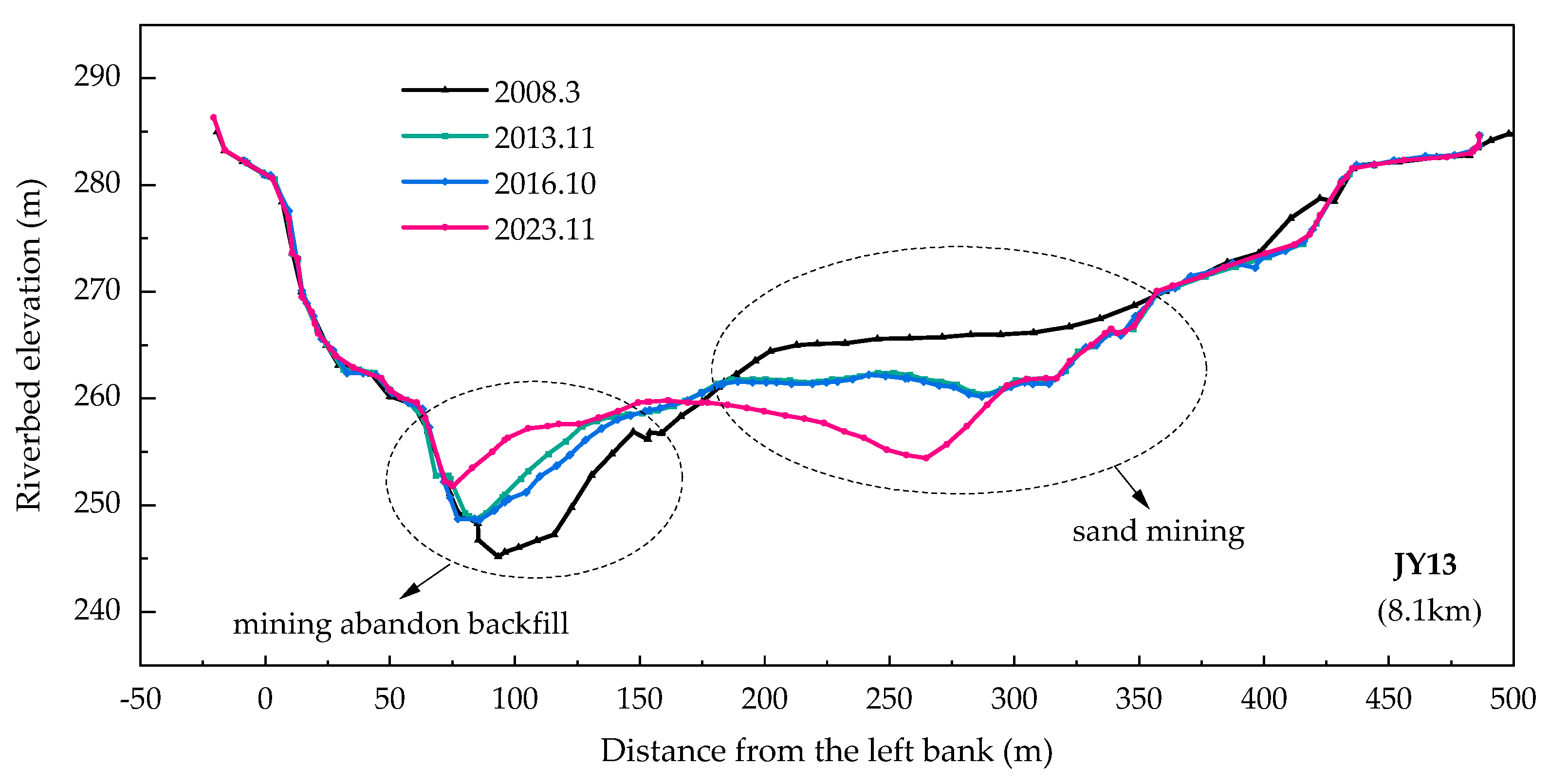
The observational data and field surveys reveal that the channel adjustments downstream of the XJB are the result of interplay between altered flow–sediment dynamics and human activities. At the representative cross-section JY13, situated 8.2 km downstream of the dam, the floodplain elevation has decreased by up to 5.6 m due to sand extraction, while the deep trench has seen a maximum deposition of 4.3 m from abandoned mining backfill between 2008 and 2013. Following the reservoir’s operation, sand mining from the floodplain on the right side resulted in a maximum incision of 8 m from 2013 to 2023 (Figure 15). It can be seen that the riverbed has undergone pit-like deformations as a consequence of localized sand mining, which in turn affects the calculation of sediment scour and deposition amounts. Since 2016, Sichuan Province has intensified its management of illegal sand mining, leading to a marked decline in these activities. Moreover, slight deposition has been observed in some sand mining pits, and the calculated erosion amounts have decreased significantly compared to the initial years of the reservoir’s operation.
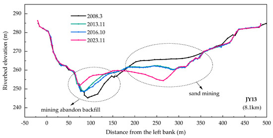
Figure 15.
Changes in the bed profile at the typical cross-section JY13 considering human activities.
In comparison, while there are no designated sand mining areas in the YZR downstream of the TGD, illegal mining persists. According to incomplete survey statistics, the amount of sand extracted from prohibited mining zones in the YZR ranges from 2070 × 104 t to 3830 × 104 t [51]. Since 2017, sand mining activities have drastically decreased as a result of the strengthening of management measures. Consequently, the impact of sand mining on riverbed deformation has been considerably reduced. Additionally, a series of waterway improvement works dominated by beach protection have been implemented in the YZR to improve navigation conditions. Between 2013 and 2017, a navigational channel improvement project was undertaken in the stretches from Yichang to Changmenxi, effectively protecting the sandbars and increasing the roughness of the riverbed. Measurements indicated slight depositions in the bars from 2016 to 2021, such as the expansion of the 35m contour area from 0.064 km2 to 0.12 km2 at Nanyangzhi sandbar. Currently, there is little washable sediment on the riverbed of the YZR, and the implementations of waterway regulation works do not alter the integral erosion–deposition characteristics of the river section.
4.4. Analysis of the Relative Importance of the Influencing Factors
During the different phases of riverbed adjustment, there is a notable variation in the relative importance of influencing factors. In the initial stages of reservoir operation, the riverbed undergoes substantial scouring due to a significant reduction in upstream sediment load. The reduced sediment concentration in the discharge flow increases the probability of movement for fine-grained sediments within the riverbed, while significant scouring and sediment replenishment take place along the channel. Coarse suspended sediments in the waterbody exchange with the bed materials. The incoming flow–sediment dynamics, in conjunction with the riverbed boundary conditions, collectively determine the extent of sediment recovery and the severity of scouring. Moreover, human activities, such as frequent sand mining in the river channel during this period, exacerbate the coarsening of the riverbed. However, as the bed material coarsens, the riverbed’s capacity to replenish sediment decreases.
Once a relative equilibrium state is reached, the intensity of scouring in both reaches is primarily constrained by riverbed boundary conditions. Insufficient sediment supply and the formation of an armor layer have weakened riverbed erosion. In contrast to the YZR, the tributary inflows downstream of the XJB provide a source of sediment deposition. Additionally, variations in flow dynamics at widening and narrowing sections result in sediment deposition in the wider areas downstream of the confluences. During this period, the impact of human activities on riverbed adjustment is comparatively minor.
5. Conclusions
The operation and impoundment of large reservoirs have substantially altered flow–sediment regimes, with the reaches immediately downstream of dams being the first to undergo channel adjustment in response. Gravel–sand bed reaches, including Xiangjiaba to Zhutuo (XZR) and Yichang to Zhicheng (YZR), which are situated immediately downstream of the XJB and TGD, predominantly exhibit vertical scouring considering the strong scour resistance of riverbanks. However, severe erosion was primarily observed during the initial years of reservoir operation, followed by a significant weakening of the erosion intensity, with a prominent reduction in washable sediment on the riverbed. It typically takes 6 to 13 years for these two study reaches to approach a state of relative equilibrium, without evidence of significant channel erosion or obvious variations in reach-scale channel geometry.
However, different phenomena emerge after the relative equilibrium state is reached. Reaches with tributaries carrying a large amount of sediment may experience siltation in some years, followed by a considerable magnitude of erosion. Otherwise, these reaches remain in a relatively stable state, with little erosion or deposition. Located in a mountainous area, there are many tributaries with a large amount of sediment transport during floods in the XZR. Sediment from these tributary inflows predominantly deposits in the wide valley sections downstream of the confluences, which is a key factor driving the alternating dynamics of erosion and deposition. In contrast, the sediment transport from the Qing River is negligible, having little impact on the riverbed evolution of the YZR downstream of the TGD.
Author Contributions
Conceptualization, S.L. and L.Z.; methodology, S.L.; formal analysis, S.L., L.Z. and J.Y.; investigation, C.L., B.D. and C.Y.; resources, L.Z. and J.Y.; data curation, C.L., B.D. and C.Y.; writing—original draft preparation, S.L. and L.Z.; writing—review and editing, S.L., B.D. and L.Z.; visualization, J.Y. and C.L.; supervision, S.L.; project administration, S.L.; funding acquisition, S.L. All authors have read and agreed to the published version of the manuscript.
Funding
This research was funded by the National Key Research and Development Program of China (grant number 2023YFC3209501); the National Natural Science Foundation of China (grant numbers U2340217, U2240206, and U2240224); and the Project of China Three Gorges Corporation (grant number 0704198).
Institutional Review Board Statement
Not applicable.
Informed Consent Statement
Not applicable.
Data Availability Statement
The original contributions presented in this study are included in the article.
Acknowledgments
The authors wish to thank the anonymous reviewers for their careful work and thoughtful suggestions that substantially improved this paper.
Conflicts of Interest
The authors declare no conflicts of interest.
References
- Batalla, R.J.; Gómez, C.M.; Kondolf, G.M. Reservoir-induced hydrological changes in the Ebro River basin (NE Spain). J. Hydrol. 2004, 290, 117–136. [Google Scholar] [CrossRef]
- Walling, D.E. Human impact on land-ocean sediment transfer by the world’s rivers. Geomorphology 2006, 79, 192–216. [Google Scholar] [CrossRef]
- Li, N.; Wang, L.C.; Zeng, C.F.; Wang, D.; Liu, D.F.; Wu, X.T. Variations of runoff and sediment load in the middle and lower reaches of the Yangtze River, China (1950–2013). PLoS ONE 2016, 11, e0160154. [Google Scholar] [CrossRef]
- Gao, Y.; Chen, L.; Zhang, W.; Li, X.; Xu, Q.X. Spatiotemporal variations in characteristic discharge in the Yangtze River downstream of the Three Gorges Dam. Sci. Total Environ. 2021, 785, 147343. [Google Scholar] [CrossRef] [PubMed]
- Brandt, S.A. Classification of geomorphological effects downstream of dams. Catena 2000, 40, 375–401. [Google Scholar] [CrossRef]
- Petts, G.E.; Gurnell, A.M. Dams and geomorphology: Research progress and future directions. Geomorphology 2005, 71, 27–47. [Google Scholar] [CrossRef]
- Graf, W.L. Downstream hydrologic and geomorphic effects of large dams on American rivers. Geomorphology 2006, 79, 336–360. [Google Scholar] [CrossRef]
- Scorpio, V.; Rosskopf, C.M. Channel adjustments in a Mediterranean river over the last 150 years in the context of anthropic and natural controls. Geomorphology 2016, 275, 90–104. [Google Scholar] [CrossRef]
- Wang, J.; Dai, Z.J.; Mei, X.F.; Lou, Y.Y.; Wei, W.; Ge, Z.P. Immediately downstream effects of Three Gorges Dam on channel sandbars morphodynamics between Yichang-Chenglingji Reach of the Changjiang River, China. J. Geogr. Sci. 2018, 28, 629–646. [Google Scholar] [CrossRef]
- Li, S.X.; Li, Y.T.; Yuan, J.; Zhang, W.; Chai, Y.F.; Ren, J.Q. The impacts of the Three Gorges Dam upon dynamic adjustment mode alterations in the Jingjiang reach of the Yangtze River, China. Geomorphology 2018, 318, 230–239. [Google Scholar] [CrossRef]
- Gilet, L.; Gob, F.; Gautier, E.; Virmoux, C.; Thommeret, N.; Houbrechts, G. Multi time scale influence of dams on bedload transport. J. Environ. Manag. 2023, 346, 118951. [Google Scholar] [CrossRef] [PubMed]
- Smith, N.D.; Morozova, G.S.; Pérez-Arlucea, M.; Gibling, M.R. Dam-induced and natural channel changes in the Saskatchewan River below the EB Campbell Dam, Canada. Geomorphology 2016, 269, 186–202. [Google Scholar] [CrossRef]
- Smith, V.B.; Mohrig, D. Geomorphic signature of a dammed Sandy River: The lower Trinity River downstream of Livingston Dam in Texas, USA. Geomorphology 2017, 297, 122–136. [Google Scholar] [CrossRef]
- Cao, W.H.; Chen, D. Sediment response and enlightenment from the Aswan High Dam. J. Sediment Res. 1998, 4, 79–85. [Google Scholar] [CrossRef]
- Erskine, W.D. Downstream hydrogeomorphic impacts of Eildon Reservoir on the mid-Goulburn River, Victoria. Proc. R. Soc. Vic. 1996, 108, 1–15. [Google Scholar]
- Jain, S.C.; Park, I. Guide for estimating riverbed degradation. J. Hydraul. Eng. 1989, 115, 356–366. [Google Scholar] [CrossRef]
- Assani, A.A.; Petit, F. Impact of hydroelectric power releases on the morphology and sedimentology of the bed of the Warche River (Belgium). Earth Surf. Process. Landf. 2004, 29, 133–143. [Google Scholar] [CrossRef]
- Syvitski, J.P.M.; Vorosmarty, C.J.; Kettner, A.J.; Green, P. Impacts of humans on the flux of terrestrial sediment to the global coastal ocean. Science 2005, 308, 376–380. [Google Scholar] [CrossRef]
- Grant, G.E. The geomorphic response of gravel-bed rivers to dams: Perspectives and prospects. In Gravel-Bed Rivers: Processes, Tools, Environments; John Wiley and Sons: Hoboken, NJ, USA, 2012; pp. 165–181. [Google Scholar] [CrossRef]
- Wang, Y.W.; Yu, Q.; Jiao, J.; Tonnon, P.K.; Wang, Z.B.; Gao, S. Coupling bedform roughness and sediment grain-size sorting in modelling of tidal inlet incision. Mar. Geol. 2016, 381, 128–141. [Google Scholar] [CrossRef]
- Naito, K.; Liu, C.; Sun, T.; Wang, Z.; Wang, Y. Extended Engelund–Hansen type sediment transport relation for mixtures based on the sand-silt-bed Lower Yellow River, China. J. Hydraul. Res. 2019, 57, 770–785. [Google Scholar] [CrossRef]
- Pemberton, E.L. Channel change in the Colorado River below Glen Canyon Dam. In Proceedings of the 3rd Federal Interagency Sedimentation Conference; U.S. Sub-committee on Sedimentation: Washington, DC, USA, 1976; pp. 5-61–5-73. [Google Scholar]
- Grams, P.E.; Schmidt, J.C.; Topping, D.J. The rate and pattern of bed incision and bank adjustment on the Colorado River in Glen Canyon downstream from Glen Canyon Dam, 1956–2000. Geol. Soc. Am. Bull. 2007, 119, 556–575. [Google Scholar] [CrossRef]
- Bi, N.S.; Sun, Z.Q.; Wang, H.J.; Wu, X.; Fan, Y.Y.; Xu, C.L.; Yang, Z.S. Response of channel scouring and deposition to the regulation of large reservoirs: A case study of the lower reaches of the Yellow River (Huanghe). J. Hydrol. 2019, 568, 972–984. [Google Scholar] [CrossRef]
- Zheng, S.; An, C.; Wang, H.; Li, L.; Wang, F.; Hassan, M.A. The migration of the erosion center downstream of the Three Gorges Dam, China, and the role played by underlying gravel layer. Water Resour. Res. 2023, 59, e2022WR034152. [Google Scholar] [CrossRef]
- Sherrard, J.J.; Erskine, W.D. Complex response of a sand-bed stream to upstream impoundment. River Res. Appl. 1991, 6, 53–70. [Google Scholar] [CrossRef]
- Yang, Y.P.; Zhang, M.J.; Zhu, L.L.; Liu, W.L.; Han, J.Q.; Yang, Y.H. Influence of Large Reservoir Operation on Water-Levels and Flows in Reaches below Dam: Case Study of the Three Gorges Reservoir. Sci. Rep. 2017, 7, 15640. [Google Scholar] [CrossRef]
- Han, J.Q.; Sun, Z.H.; Li, Y.T.; Yang, Y.P. Combined effects multiple large-scale hydraulic engineering on water stages in the middle Yangtze River. Geomorphology 2017, 298, 31–40. [Google Scholar] [CrossRef]
- Hu, Y.; Li, D.F.; Deng, J.Y.; Yue, Y.; Zhou, J.X.; Chai, Y.F.; Li, Y.T. Mechanisms controlling water-level variations in the Middle Yangtze River following the operation of the Three Gorges Dam. Water Resour. Res. 2022, 58, e2022WR032338. [Google Scholar] [CrossRef]
- Ma, H.; Nittrouer, J.A.; Fu, X.; Parker, G.; Zhang, Y.; Wang, Y.; Zhang, Q.; Li, W.; Liu, J. Amplification of downstream flood stage due to damming of fine-grained rivers. Nat. Commun. 2022, 13, 3054. [Google Scholar] [CrossRef] [PubMed]
- Chen, Q.W.; Li, Q.Y.; Lin, Y.Q.; Zhang, J.Y.; Xia, J.; Ni, J.R.; Li, Y.; Wang, C. River damming impacts on fish habitat and associated conservation measures. Rev. Geophys. 2023, 61, e2023RG000819. [Google Scholar] [CrossRef]
- Hu, Y.; Deng, J.Y.; Li, D.F.; Lu, X.X.; Zhou, J.X.; Wang, C.L.; Li, Y.T. Shifted flood and ecology regimes due to channel bargreening and increased flow resistance in a large dammed river. Geophys. Res. Lett. 2024, 51, e2024GL110890. [Google Scholar] [CrossRef]
- Belletti, B.; Garcia de Leaniz, C.; Jones, J.; Bizzi, S.; Börger, L.; Segura, G.; Trigo, M.; Mariani, M.; Souchon, Y.; Tissot, B. More than one million barriers fragment Europe’s rivers. Nature 2020, 588, 436–441. [Google Scholar] [CrossRef] [PubMed]
- Lai, X.; Yin, D.; Finlayson, B.L.; Wei, T.; Li, M.; Yuan, W.; Yang, S.; Dai, Z.; Gao, S.; Chen, Z. Will river erosion below the Three Gorges Dam stop in the middle Yangtze? J. Hydrol. 2017, 554, 24–31. [Google Scholar] [CrossRef]
- Dai, Z.; Liu, J.T. Impacts of large dams on downstream fluvial sedimentation: An example of the Three Gorges Dam (TGD) on the Changjiang (Yangtze River). J. Hydrol. 2013, 480, 10–18. [Google Scholar] [CrossRef]
- Lyu, Y.W.; Zheng, S.; Tan, G.M.; Shu, C.W.; Han, Q. Morphodynamic adjustments in the Yichang–Chenglingji Reach of the Middle Yangtze River since the operation of the Three Gorges Project. Catena 2019, 172, 274–284. [Google Scholar] [CrossRef]
- Zhou, M.R.; Xia, J.Q.; Deng, S.S.; Lu, J.Y.; Lin, F.F. Channel adjustments in a gravel-sand bed reach owing to upstream damming. Glob. Planet. Change 2018, 170, 213–220. [Google Scholar] [CrossRef]
- Zhu, L.L.; Chen, D.; Yang, C.G.; Chen, K.B.; Li, S.X. Sediment deposition of cascade reservoirs in the lower Jinsha River and scouring of river channel under dam. J. Lake Sci. 2023, 35, 1097–1110. [Google Scholar] [CrossRef]
- Du, Z.D.; Qin, L.L.; Dong, X.Y. Analysis of siltation causes in the downstream of Xiangjiaba Hydropower Station on Jinsha River in 2020. J. Sediment Res. 2024, 49, 45–50. [Google Scholar] [CrossRef]
- Guo, C.; Jin, Z.W.; Guo, L.C.; Lu, J.Y.; Ren, S.; Zhou, Y.J. On the cumulative dam impact in the upper Changjiang River: Streamflow and sediment load changes. Catena 2020, 184, 104250. [Google Scholar] [CrossRef]
- Cao, G.J.; Wang, J. Measurements and Studies of Hydrological and Sediment Data in the Three Gorges Project; Science Press: Beijing, China, 2015. [Google Scholar]
- Changjiang Water Resources Commission. Analysis of Channel Degradation Downstream of the Three Gorges Dam; Scientific Report of CWRC (Wuhan); Changjiang Water Resources Commission: Wuhan, China, 2015. [Google Scholar]
- Changjiang Water Resources Commission. Changjiang Sediment Bulletin. 2015. Available online: http://www.cjh.com.cn (accessed on 25 May 2017).
- Xia, J.Q.; Deng, S.S.; Lu, J.Y.; Xu, Q.X.; Zong, Q.L.; Tan, G.M. Dynamic channel adjustments in the Jingjiang reach of the middle Yangtze River. Sci. Rep. 2016, 6, 22802. [Google Scholar] [CrossRef] [PubMed]
- Yang, X.Y.; Hu, H.H.; Zhang, Z.H.; Liu, C.H. Relationships of floodplain and main channel processes and flow and sediment in the Lower Yellow River. J. Sediment Res. 2020, 45, 16–20. [Google Scholar] [CrossRef]
- Yang, S.L.; Milliman, J.D.; Li, P.; Xu, K. 50,000 dams later: Erosion of the Yangtze River and its delta. Glob. Planet. Change 2011, 75, 14–20. [Google Scholar] [CrossRef]
- Yang, Y.P.; Zheng, J.H.; Zhang, H.Q.; Chai, Y.F.; Zhu, Y.D.; Wang, C.Y. Impact of the Three Gorges Dam on riverbed scour and siltation of the middle reaches of the Yangtze River. Earth Surf. Process. Landf. 2022, 47, 1514–1531. [Google Scholar] [CrossRef]
- Xu, J.X. Evolution of mid-channel bars in a braided river and complex response to reservoir construction: An example from the middle Hanjiang River, China. Earth Surf. Process. Landf. 1997, 22, 953–965. [Google Scholar] [CrossRef]
- Liu, S.W.; Zhang, P.; Miao, W.; Wang, Z.L.; Li, D.X. Study on sediment transport law of flood event in different areas of the Jialingjiang River basin. Adv. Water Sci. 2022, 33, 38–47. [Google Scholar] [CrossRef]
- Dong, B.J.; Zhang, O.Y.; Xu, Q.X.; Yuan, J.; Zhu, L.L. Study on characteristics of sediment yield under heavy rainfall in upstream of Three Gorges Reservoir during flood season in 2018. Yangtze River 2019, 50, 21–25. [Google Scholar] [CrossRef]
- Xu, Q.X. Study of sediment deposition and erosion patterns in the middle and downstream Changjiang mainstream after impoundment of TGR. J. Hydroelectr. Eng. 2013, 32, 146–154. [Google Scholar]
Disclaimer/Publisher’s Note: The statements, opinions and data contained in all publications are solely those of the individual author(s) and contributor(s) and not of MDPI and/or the editor(s). MDPI and/or the editor(s) disclaim responsibility for any injury to people or property resulting from any ideas, methods, instructions or products referred to in the content. |
© 2024 by the authors. Licensee MDPI, Basel, Switzerland. This article is an open access article distributed under the terms and conditions of the Creative Commons Attribution (CC BY) license (https://creativecommons.org/licenses/by/4.0/).