Abstract
Constructing digital models of public spaces of social networks found in traditional villages helps us explore the logic behind the interactions that occur within various relationships as well as achieve the optimization of spatial layouts and the equalization of the different use needs that social groups have. However, this analytical method has not been fully studied in the field focusing on the rationality of public spaces in traditional villages. This paper takes the traditional village protection demonstration area in Mentougou District, Beijing, China, as the object of research and selects three different forms of traditional villages to be analyzed. It tries to excavate the universal laws and unique differences in the models of the different forms of traditional villages and establish models for quantitative research, such as index calculation, so as to increase the depth and accuracy of research and embody the characteristic laws of the spaces studied in terms of the nature of the structures and relationships that are part of these spaces. The results show that the spatial characteristics of the different forms of traditional villages are obviously different from the relevance, equalization, and connectivity of spatial networks. The cluster form of traditional villages tends to focus on the villagers’ use demands and the assessment of the spatial status quo by increasing the number of spatial nodes and transforming spatial functions in order to achieve higher equalization. The dispersed form of traditional villages tends to focus on optimizing the relevance of spatial network structures. The linear form of traditional villages tends to establish public spaces so as to increase the depth and accuracy of research. Villages ought to establish direct links between public spaces in order to increase the connectivity of traditional villages. This study provides a rational basis for the differentiated planning decisions of traditional villages and lays the foundation for the promotion of the smooth and sustainable development of regional villages.
1. Introduction
In response to the evolving trajectory of social research [1], urban research has experienced a perceptible transformation [2]. It has transcended the confines of solely investigating the physical realm and embraced a holistic approach wherein the physical environment converges with the intangible facets including that of social interactions [3]. The focus has shifted towards intricate explorations of the interplay between spaces, the dynamic relationship between spaces and individuals, and the multifaceted connections between people themselves. In the ongoing endeavor of urban development, the foundational prerequisite for public spaces design remains functionality. However, a disconcerting trend is becoming increasingly apparent as planning and design endeavors have gravitated towards an excessive functionalization of public spaces [4]. This shift has regrettably led to the neglect of the vital role played by the inhabitants of cities, their emotional requisites, and the essential humanistic considerations that should underpin urban design and development.
A social network [5], which is defined through a collection of theories delving into the intricate web of human relationships [6], directs its focus toward the patterns of these connections rather than the inherent attributes of the individuals. This perspective emerges as a pivotal lens for the scrutiny of urban spaces. Through the prism of the social network perspective, the very essence and characteristics of urban spaces have undergone a profound metamorphosis that has been catalyzed through reforms in economic and social systems [7]. Urban space transcends its prior definition as a mere physical expanse and instead assumes the role of a vital conduit for social networks. It serves as a bridge of cross-fertilization that is intimately woven into the tapestry of residents’ social and public lives. Simultaneously, the criteria for appraising the effectiveness of public spaces are undergoing a necessary evolution. No longer confined to mere quantitative, structural and dimensional considerations, the new yardsticks applied to these criteria center on their ability to nurture the flourishing of social networks [8]. Paramount among these attributes is their capacity for continuity and integration, serving as the yardstick employed foremost in the judgment of social networks [9].
Foreign theoretical research on social network analysis has already produced rich results, ranging from theoretical research to spatial practice. Overseas scholars have found that by applying this method to a city as a complex, giant system, the network of urban spatial systems can be revealed quantitatively and visually. In other words, the law of urban spatial system networks can be quantitatively and intuitively revealed after applying this method.
In recent years, the application of social network analyses has been more and more closely related to urban spatial planning in China. Domestic research on the social network analysis method mainly focuses on two different scales as follows: the urban spatial scale and the rural public spaces scale. For the urban spatial scale, scholars in China have found that social network analysis can be used to innovatively study the city as a whole in terms of the protection of social networks in historic districts, the characteristics of commercial as well as leisure space networks, and the accessibility of leisure spaces. On the scale of rural public spaces, many scholars have focused on the study of public spaces from different perspectives by using the social network analysis method, which is found to have the unique advantage of being suitable for analyzing closed and well-defined areas. As a typical representation of rural public spaces, traditional village public spaces have a high research value. Compared with other analysis methods such as GIS, the social network analysis method pays more attention to people’s needs, so it is more suitable for analyzing the public spaces within traditional villages. To sum this up, progress in the application of the social network analysis method in urban planning shows a trend of being gradually deepened from use in macro research to use in micro research since more attention is being paid to its operation and application in small-scale spaces.
At present, scholars’ research on the public spaces of traditional villages has included various aspects. Liu Chunla believes that the promotion of China’s new urbanization strategy makes closed and stable traditional villages suffer from the impact. As a large number of the original inhabitants move out of the countryside, the traditional villages are gradually being hollowed out and are aging; the material space is gradually being disconnected from the original social relations within the villages as well. Hence, the original cultures of traditional villages are difficult to continue, and villagers cannot obtain a sense of security, identity, and belonging from the rural material space [10,11]. Therefore, thinking about the internal logic of the rationalization of space and updating it with the needs of society has become a problem that needs to be solved. Zhou Li believes that the capitalization of rural space and the convergence of urban and rural social patterns caused by rapid urbanization have weakened the rural nature of vernacular society. She suggests analyzing villagers’ community networks as a starting point, protecting the original nature of the social texture of rural settlements as an orientation point, and analyzing the public spaces of the settlement as the key creation point in planning as parts of a holistic research idea that aims to promote social, economic, and ecologically harmonious communion as well as the sustainable development of rural settlements [12]. Zhang Yi found that changes in ideology and lifestyle have led to the internal space of traditional villages experiencing difficulty in adapting to the diversified spatial needs of villagers, and pointed out that the changes in ideology and lifestyle also affected the construction of traditional village public spaces. The phenomenon of homogenization of village public spaces in actual planning [13], including constructive destruction and one-sidedness of a thousand villages, is also explored. According to empirical investigations and observations, the sociological networks perspective dominated by structure and relationship to study the human–land relationship of traditional villages can better reflect its spatial characteristic law in essence [14]. With the rapid urbanization process and rural revitalization construction, the protection and development of traditional villages has always been a hot issue of concern for all walks of life, which is of far-reaching significance in promoting rural construction. Traditional villages, as a form of “community“ living space, are the physical support of Chinese farming civilization and the material carrier of historical and cultural inheritance and emotional memory. This refers to the clear and stable living level and spatial structure of the settlement formed after a long period of precipitation on the natural basis of a specific region. The public spaces of traditional villages, as an indispensable part of the material carrier, connect and link the households in the villages and play an important role in the overall stability of the villages [15]. However, the steep decline in the total number of natural villages [16] indicates a rapid and irreversible decline of village extinction in China. Under the premise of the lack of village vitality, the remodeling of the public spaces of traditional villages may slow down or delay the process of village extinction and improve the living environment of traditional villages.
With the continuous expansion of research, scholars have comprehensively analyzed the public spaces of traditional villages from a sociological perspective [17]. Due to the fact that villagers have always been the main social group living in traditional villages for generations [18,19], the planning of traditional villages should be “people-oriented”, i.e., under the premise of rational utilization and development of existing village resources to ensure the daily behavioral and activity needs of the main user group of villagers at the maximum extent. Space, as a material carrier for villagers to feel and experience, bears both “spatial structures” and “social relationship”. Therefore, under the premise of shifting from spatial research to material research, the cognition and perspective of the public spaces of traditional villages have also changed, from research of solely the material environment to interactive research of the material and immaterial environment (including social relations), focusing on the relationship between spaces, spaces and people, and people themselves. According to Zhang Yi et al., the enhancement of the public spaces of traditional villages is guided by an in-depth analysis of its sociological causes, and a series of enhancement strategies for the public spaces of traditional villages is put forward, such as the principle of human-centeredness and the principle of holistic protection [20].
Taking the traditional villages in the Mentougou area [21] as an example, we explore the enhancement strategy of its traditional village public spaces based on a sociological analysis. Mentougou District was successfully selected as the 2022 Traditional Villages Concentrated and Continuous Protection and Utilization Demonstration Area in April 2022, and it is a typical traditional village concentrated and continuous protection and utilization demonstration area in Beijing [22]. Based on the natural geographic conditions of the Mentougou mountainous area, this study comprehensively considered the mountainous conditions, hydrological conditions, transportation conditions, and other different natural geographic elements and selected three different forms of traditional villages in the mountainous area of the region for in-depth analysis, that is, three typical village forms of cluster form, linear form, and dispersed form, respectively [23]. In addition, by using social network analysis method and comparing with traditional villages, network indicator models of different forms of villages were found [24]. By using the social network analysis method [25], we compared and found out the network index law of different forms of villages and discovered the interactive relationship between the spaces and people in different forms of traditional villages.
There has been a great deal of research in the literature on the connection between the social life needs of people in traditional villages and the public spaces of traditional villages [26]. Nevertheless, the research on the public spaces of traditional village villagers under the premise of social network analysis is still limited, and there is still a gap in the research on the public spaces that can meet the needs of villagers’ activities in traditional villages. Therefore, this study restricts the scope of analysis to the close interaction between villagers and the spaces in the public spaces of traditional villages and takes the scope of their activities as the main research object. Nowadays, the traditional villages in the Mentougou area are in a state of decline, and their development is searching for a very novel analysis method and transformation and enhancement model [27]. This study has two main objectives: first, to determine the rationality of the existence of public spaces in traditional villages through the villagers’ range of social activities in the villages; second, to create a diversified space with an equal supply and demand that can satisfy the villagers’ activities and daily social needs. The question is, how do we improve the quality of public spaces in traditional villages in order to promote friendly social interactions among villagers? Using three villages in Mentougou District as case studies, this study explores the actual needs of people’s activities in traditional villages, which will help us better suggest public space optimization by village type.
2. Methodology
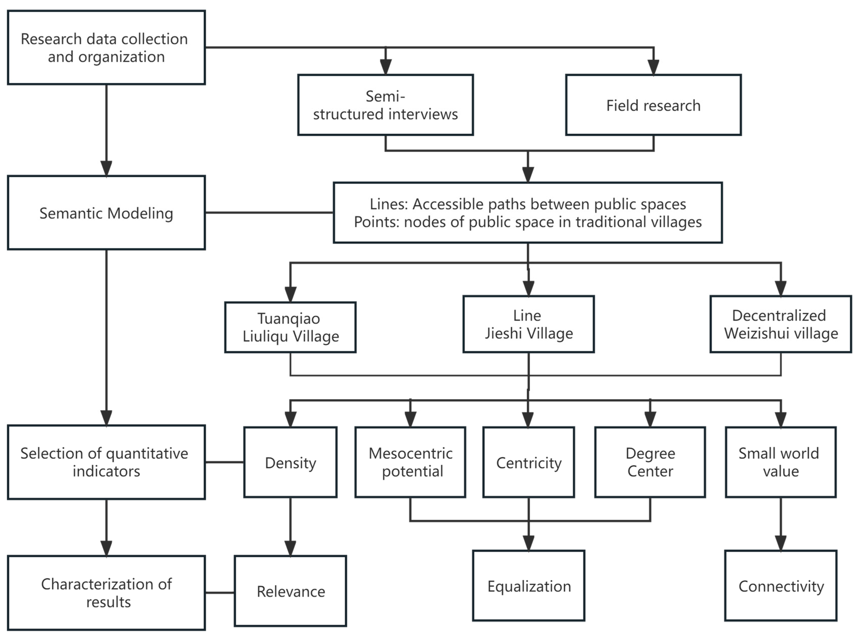
Social network analysis [28] is a methodology and technique centered on graph-theoretic measurement [29], both as a way of conducting research on interactions between actors and for social structure [30]. Spatial nodes, as the material carriers of villagers’ activities, carry their inherent geographic location information. The “line” is based on the accessibility of the spatial nodes and the paths of villagers’ activities between the spatial “points” of the traditional village. The most direct manifestation of the “line” is the road transportation networks within the traditional village and the different levels of roads determine the way of access. It also reflects the social attributes of the spatial nodes and the villagers’ demand for them, and the degree of activity of social activities within the space [31]. According to the principle of social network analysis, the public spaces of the three case villages is used as the node. The connecting relationship between the spaces is used as the connecting line to construct the rural spatial networks. The route of spatial network construction is shown in Figure 1.
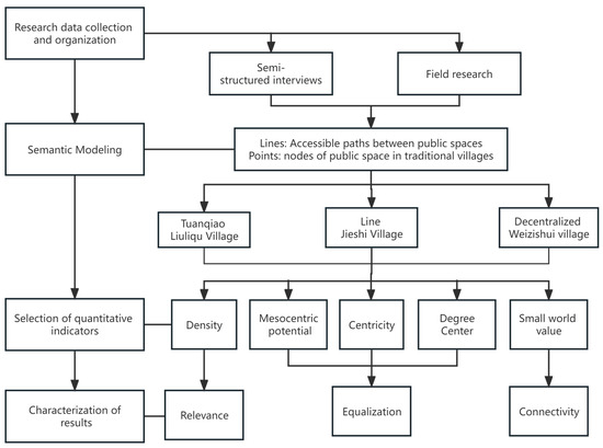
Figure 1.
Traditional village public spaces network modeling route.
2.1. Sample Selection
The use of social network analysis to study the structure of public spaces in traditional villages requires that the boundaries of the space be clear and highly recognizable in order to ensure that the space is abstracted into separate nodes. According to the data, as the main location of traditional villages, in Beijing, there are 26 traditional villages in six districts and counties under its jurisdiction. In order to ensure the richness and comprehensiveness of the spatial types, the study area should be a village with a complete public spaces system, a large area, and clear regional boundaries. In this study, three typical village cases of cluster, linear, and dispersed forms were selected from the Mentougou Traditional Villages Concentrated and Continuous Protection and Utilization Demonstration Area [32]. Liuliqu Village, Jieshi Village, and Weizishui Village are the main targets of this study because of their high population concentration, rich types of public spaces, and distinctive morphological features. Through comparing the results, the pattern of network indicators in different forms of villages can be discovered so that public spaces optimization by village type can be proposed better [33].
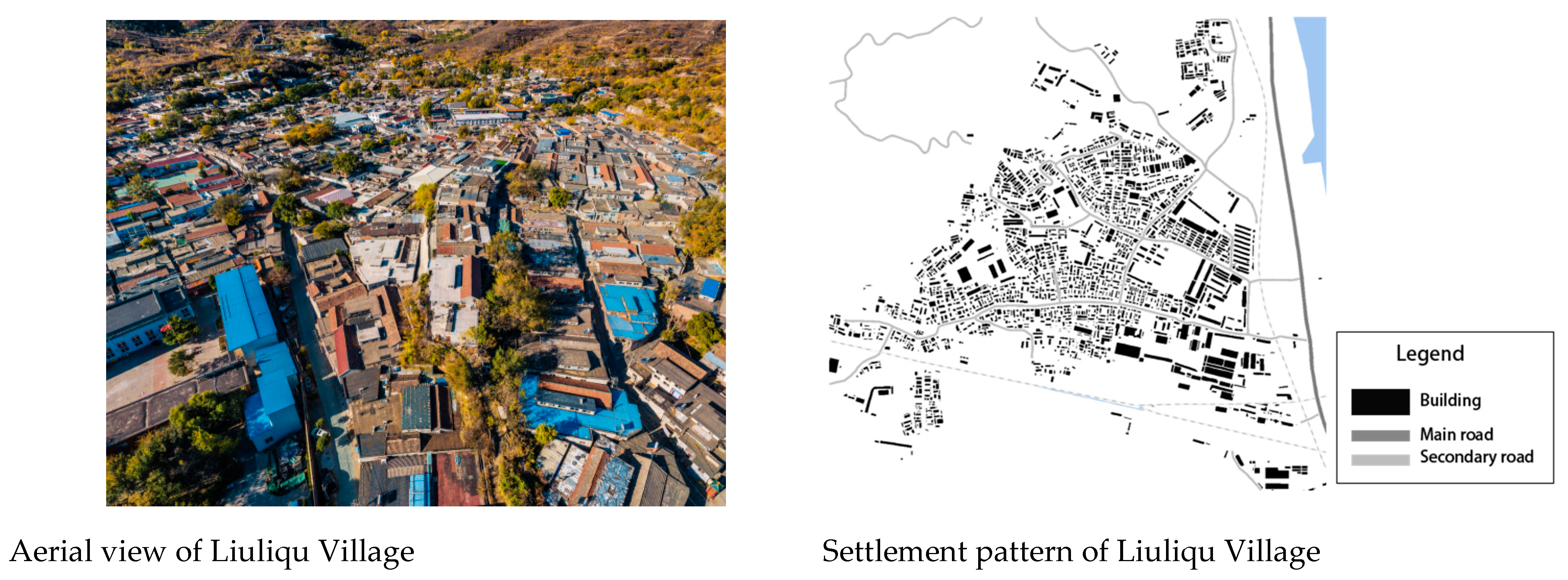
Liuliqu Village is in cluster form, as shown in Figure 2. It is located in the west of Beijing, 25 kilometres away from downtown, and belongs to Longquan Town of Mentougou District. Liuliqu Village is situated on the mountains and surrounded by water. The west side of the village is backed by Jiulong Mountain, which is situated at the foot of the north side of the mountain. The east side of the village is adjacent to the Yongding River, which is the location of the river out of the mountain passes. In addition, it is adjacent to the urban arterial road called Shuitandan Road. There are two railroads passing through the south side of the village, the Fongsha Railway and the Dazhen Railway, both of which have been in operation for a very long period of time. It is a quiet and elegant old village with a quiet and elegant environment.

Figure 2.
Liuliqu Village (cluster form).
Jieshi Village is in the linear form, as shown in Figure 3. It is located in the southwest of Yanyi Town, Mentougou District, Beijing, preserving many ancient dwellings and simple folk customs. It has been honored with the titles of Chinese Traditional Village and Beijing Rural Folk Tourism Village. Jieshi Village has a long history and deep cultural heritage, and it is especially famous for its large number of wells. In addition, it was named “the first village with wells in western Beijing” by the China Urban Construction Research Institute. Now, the main preserved cultural relics are a monument to rebuild the Shengquansi Temple and a Dragon King Temple. In Gaojiaguan, a Jin Dynasty Ding kiln flower bowl and dish, twelve Chinese zodiac bronze mirror, bronze lamps, and so on were unearthed.
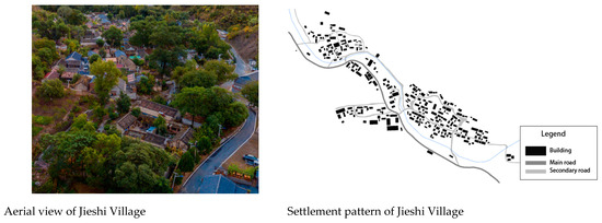
Figure 3.
Jieshi Village (linear form).
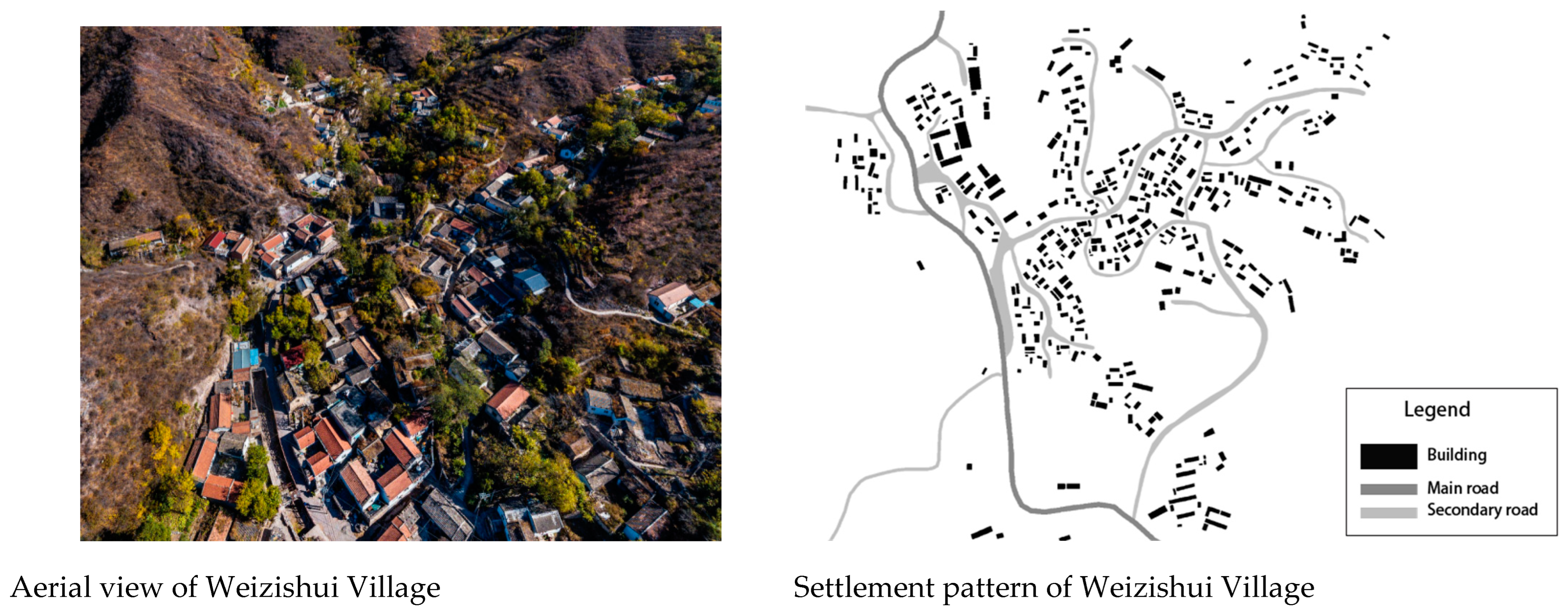
Weizishui Village is in the decentralized form, as shown in Figure 4. It is located in the village under the jurisdiction of Yanyi Town, Mentougou District, Beijing, in the northern part of the Taihang Mountainous Region, with a long history of nearly 600 years. Weizishui Village is located in the low mountainous area with an altitude of 560 m and an area of 10,000 square meters. Historically, it was rich in water, and there were a lot of reeds on the upper and western sides of the river gorge. The village is located in a place called “Nine Liangs and Eight Forks”, i.e., nine mountain beams converging in a valley, which is regarded as a feng shui treasure of “Nine Dragons Playing in a Golden Basin”.
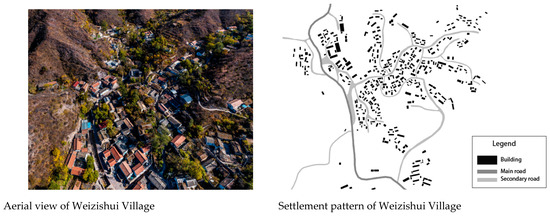
Figure 4.
Weizishui Village (decentralized form).
2.2. Data Collection
In this paper, three typical traditional villages of different forms in Mentougou were selected. Through actual research and semi-structured interviews [34], villagers were randomly surveyed and interviewed to understand the utilization rate of public spaces, villagers’ interactivity and satisfaction level, and other characteristics [35]. The nodes of public spaces with high frequency of use by villagers were numbered and labeled, and the nodes and action paths that villagers passed through to the target public spaces were identified. The “point” and “relationship” data were collected and organized [36]. Secondly, a symmetric adjacency matrix was constructed using social network analysis methods and principles to build a visual spatial network model of traditional village public spaces. Through the social network analysis method, the network parameters were analyzed and calculated to summarize the network characteristics of the spatial layout of different forms of traditional villages. Finally, based on the above research, the targeted strategies for the spatial renewal of traditional villages were proposed.
In March 2022, two different time periods, namely, weekdays and rest days, were chosen to randomly conduct survey interviews with villagers in Liuliqu Village, Jieshi Village, and Weizishui Village to obtain the characteristics of the utilization rate of public spaces, villagers’ interactivity, and satisfaction level. The questionnaires mainly included items such as the basic information of villagers, types of going to public spaces, path of action, duration of stay, and ways of interaction. A total of 347 questionnaires were distributed, of which 304 were valid feedback, with an effective rate of about 87.6%. The SPSS analysis results show that the questionnaire credibility was higher than the standard of higher reliability [37], and the data had a certain degree of credibility and stability. The public spaces nodes that are frequently used by villagers were numbered to determine the nodes and action paths that villagers pass through to the target public spaces. The SNA software UCINET6.0 was used to process the data and produce a visualized public spaces node flow map in NET-DRAW. From the three aspects of public spaces network relevance [38], equalization, and connectivity, density, centrality index, and small-world value were selected as evaluation indexes, respectively, then we analyzed the network structure characteristics [39]. According to the constructed public spaces network structure model of the three villages, the overall parameters network relevance, equalization, connectivity three dimensions, and node parameters for characterization and the social network analysis method of the key indicators of this concept were transformed into the practical research ideas in this paper.
2.3. Key Indicators
The micro-renewal of traditional village public space [40] based on the social network model needs to consider the interaction needs of villagers. It is also necessary to protect the vernacular nature of traditional villages and to maintain the integrity and stability of the overall structure of the rural social network [41]. In this study, indicators such as density, intermediate center potential, and small-world value were selected to analyze the structural characteristics of the traditional village public spaces network model.
The total number of points adjacent to a particular public space node is called “density”, which reflects the relevance between nodes. The higher the density of the networks, the greater the influence it can have on the behavior and attitudes of actors in the networks and on the internal connectivity of the public space networks.
Density is the ratio of the number of connections that actually exist in the networks to the theoretical maximum number of connections it is possible to have. It is an important indicator of how closely the networks are connected. The formula is calculated as the Equation:
In the formula, N is the number of nodes and L is the number of connections that actually exist in the graph.
The intermediate centripetal potential is an important indicator of the degree of integration and equalization of the overall networks, reflecting their central tendency. It measures the degree of overall equalization of network relations in the network structure with the centralization trend and the degree of centripetalism of the public space networks. The calculation formula is Equation:
Intermediate centrality reflects the ability of nodes to act as mediators. Actors with a high degree of centrality are located in key positions in the networks and are able to control and influence interactions between others. It also measures the degree to which a node is at the center of spatial networks.
The formula is:
In the formula, gjk is the number of geodesic paths between point j and point k, and gjk (Ni) is the number of all geodesic paths between j and k that pass through point i.
Degree centrality is a quantitative analysis of individual rights and reflects the relative importance of points. A higher degree centrality of a node indicates that it is more likely to be located in the center of the networks. The formula is:
In the formula, C′D is the relative degree centrality and d is the centrality measure of the actors in the graph of size n.
The small-world value is an important measure of network relatedness and wholeness. As the small-world quotient becomes higher, actors in the networks can reach others through only a few people, and the spatial system has high accessibility and wholeness as well. The formula is calculated as Equation:
In the formula, Cactual is the clustering coefficient of the actual networks; Lactual is the average path length of the actual networks; Crandom is the clustering coefficient of the virtual random networks; Lrandom is the average path length of the virtual random networks.
3. Results
3.1. Results of Spatial Modeling Analysis of Traditional Villages of Various Forms
The concepts of the basic parameters of the social network analysis method were translated into the concepts used in this paper with practical relevance. Relevance is a measure of the number and connectivity of essential attributes in public spaces. Equilibrium measures the tendency of the model to concentrate and the closeness of spatial connections. Connectivity corresponds to the ease with which spaces are connected to each other.
3.1.1. Cluster Form-Liuliqu Village
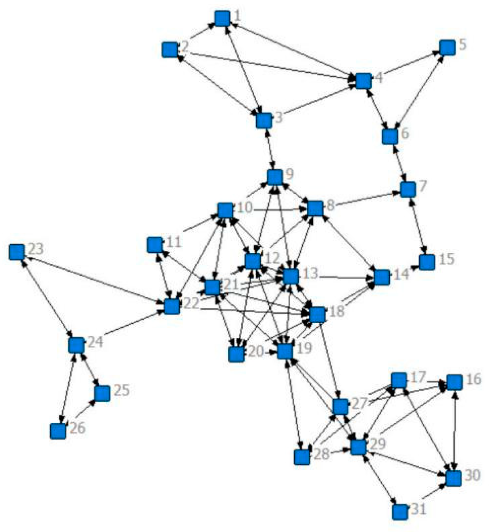
The social network map of Liuliqu Village shows a core agglomeration pattern, which is that of a typical cluster-form village, as in Figure 5. The density value of the social network model is 0.157, the middle center potential is 25.54%, and the small-world value is 2.430. From the above, it can be seen that the overall density value of the social network model is large; the overall network relevance is high; the overall middle center potential value of the spatial networks is low; the overall spatial network integration is low; the resource integration ability is weak; the small world characteristics are not obvious. The cohesion of the spatial nodes of traditional villages is not strong as reflected from the macro level. Influenced by the spatial layout and functional factors, the network structure presents a small-scale aggregation of the core and a looser overall state. Some nodes do not form a good relevance with the overall space, and space resources are easily wasted.
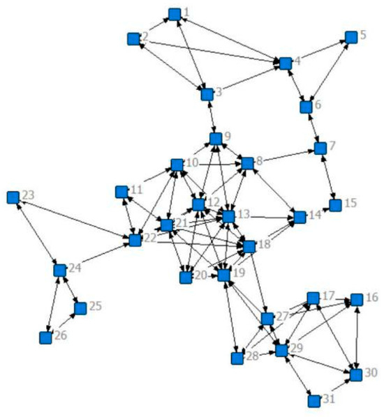
Figure 5.
Social network map of the village of Liuliqu.
The number of squares, green areas, and activity rooms that can be more connected with other leisure space nodes in the traditional villages of cluster form is low. Although the overall equal compactness is low, the adjacent public spaces are more closely connected to each other. The villagers’ needs for daily activities in the overall public spaces are not satisfied.
3.1.2. Linear Pattern-Jieshi Village
The social network map of Jieshi Village shows an obvious linear pattern. This case is representative for the study of the spatial network characteristics of linear texture villages, as shown in Figure 6. The density value of this network is 0.1053, the middle center potential is 37.08%, and the small-world value is 3.252. This indicates that the connectivity between public spaces points in the spatial networks of Jieshi Village is high. By contrast, the overall degree of spatial relevance is low, and the structure is more fragile, which is in line with the characteristics of paths in linear villages.
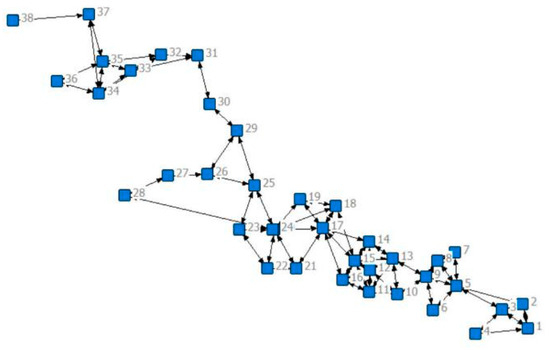
Figure 6.
Social network map of the village of Jieshi.
The accessibility of some spatial nodes in the road network design of linear-form traditional villages is not strong, and villagers cannot enter the activity space through the most concise route. The path characteristics of linear villages are that the public spaces between different buildings are more difficult to connect. The overall connectivity tightness is lower, the same as the degree of road network association.
3.1.3. Decentralized Form-Weizishui Village
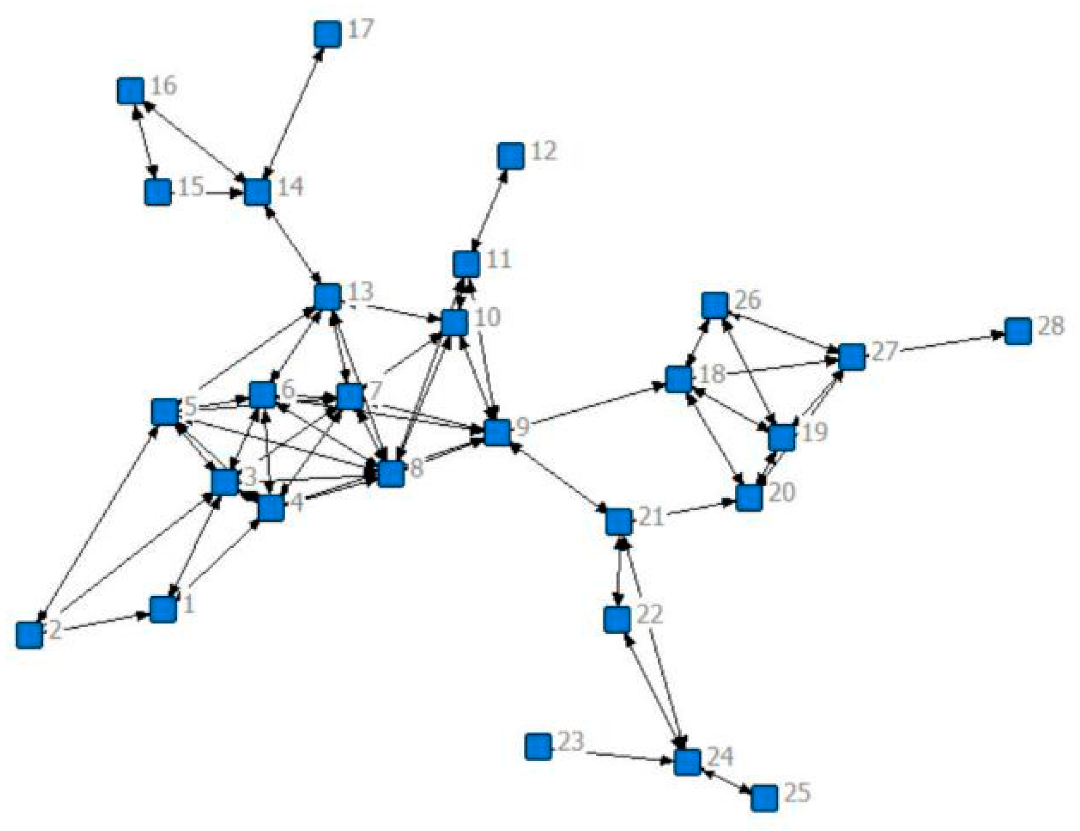
The social network map of Weizishui Village shows a decentralized pattern in public spaces, as in Figure 7. The density value of the network is 0.1548; the power of the middle center is 45.43%; and the value of the small world is 2.262. The network is clearly segmented into clusters. Points are not closely connected to each other, but are more evenly distributed. Core roads are central and most connections are mediated through the core area. The whole network forms four sub-groups, and the interaction between the sub-groups is weak.

Figure 7.
Social network map of the village of Weizishui.
The overall spatial distribution of traditional village nodes in the decentralized form is uneven, resulting in the fact that although some core spaces have a high degree of relative centrality in the networks and a relatively important position in the network, the core nodes are unable to give full play to the “intermediary” effect in the integration of spatial resources, and the integrating effect on the whole network is not obvious; some public spaces in remote locations on the edge of the countryside are in the center, and most of the connections have to go through the core area as a mediator. Some of the public spaces in remote locations on the edge of the countryside have a lower degree of intermediate centrality, which has less influence on other spatial nodes and reduces the degree of integration of the networks as a whole.
3.2. Comparison of Indicators of Each Typical Form of Traditional Village
3.2.1. Relevance of Spatial Network
The comparison of the data reveals that the village relevance is higher in Liuliqu Village in the cluster form and Weizishui Village in the dispersed form and the lowest in Jieshi Village in the linear form. It can be seen that the degree of connection between the public spaces of traditional villages is generally weak, and the overall relevance of the network is low. The specific data are shown in Table 1.

Table 1.
Comparison of the relevance indexes of each morphological village.
The unique characteristic of linear-form villages is that the network is more fragile. Linear-form traditional villages have less influence on the behaviors and attitudes of actors in the network, while the internal connectivity of the public spaces network is weaker. The low density of spatial grid connectivity highlights the long layout of linear-form villages and the low internal connectivity of public space. In contrast, clustered and dispersed traditional villages have a greater influence on the behavior and attitudes of the actors in the networks than linear traditional villages, and the internal connectivity of the public space grid is stronger. The clustered form of traditional villages has strong accessibility between all public spaces due to the close aggregation, which enhances the density of the overall spatial grid of the village. Although the dispersed form of village public spaces presents a dispersed form, according to on-site research results, public spaces nodes have their unique functions and uses. These spaces become places for community members to communicate, interact, and socialize, as shown in Table 1, showing a high density of village spatial grids.
3.2.2. Equalization of Space Networks
The comparison of the data reveals that decentralized traditional villages have the highest degree of equilibrium, while the spatial equilibrium of the cluster form is the lowest, in line with the universal law. The overall degree of equilibrium of decentralized traditional villages in the network structure is higher in relation to the centralization trend and the centripetal degree of the public spaces network. The specific data are shown in Table 2.
Table 2.
Comparison of equilibrium indicators for villages of various forms.
Cluster-shaped-form traditional villages have relatively low centripetal potential values, which means that the overall degree of equilibrium and group dynamics are relatively low. The result of cluster villages appears in centralization, where the center of the village is located in the cluster area with relatively little public spaces around it. This structure makes core values low. A few core public spaces are in key positions to control and influence communication among others, while other public spaces have relatively few opportunities for communication.
The central potential value of the linear-form villages is centered, which means that the overall equilibrium and concentration trend is relatively equal. Due to the structural characteristics of linear villages, the center of the village is usually located in the middle of the village with a certain centripetal orientation. This structure makes the center potential value relatively even compared to the average. The public spaces are relatively evenly distributed in the networks, and the opportunities for mutual interaction are also relatively even.
Decentralized-form traditional villages have the highest central potential value, which means that the overall equalization and concentration trend is relatively strong. The public spaces of the decentralized-form villages are more widely distributed, forming a decentralized network structure. In this structure, there is no obvious center position, and each public space possesses a relatively independent position. This decentralized structure makes the central potential value the highest, and the interactions between public spaces are relatively equal, without having obvious control and influence relationships.
3.2.3. Connectivity of Space Networks
A high degree of nodalness of a public space means that the number of public spaces directly accessible to it by road is high. For public activities, it means that villagers tend to travel from other locations to a certain location for activities. Intermediate degree, on the other hand, emphasizes the concentration tendency. Normally, the hierarchy of spatial structure should correspond to the high or low values of intermediate degree, but this hierarchical relationship may be biased when examining the distribution of actual activities. For example, the core public spaces serve a controlling role in the spatial structure, but few public activities take place.
The data comparison reveals that the connectivity of Liuliqu Village in the cluster form is the highest, and the connectivity of Jieshi Village in the linear form is the lowest. It can be seen that the connectivity between the public spaces of traditional villages is generally weak, and the overall relevance of the network is low. The specific data are shown in Table 3.
Table 3.
Comparison of connectivity indicators for villages of various morphologies.
The small-world values and clustering coefficients of the linear form traditional villages are relatively low, which means that the interconnectivity between public spaces is weak. Due to the structural characteristics of linear villages, the longer the dissemination path of information and resources between public spaces, the lower the accessibility, indicating that behavior and activities tend to be concentrated within a certain range.
The small-world value of the traditional village in the cluster form is in the middle, which shows that the interconnectivity between public spaces in it is suitable. The public spaces in the cluster-shaped village are connected together in a relatively aggregated way, and the dissemination paths of information and resources are relatively short, with higher accessibility. Due to the clustered layout of the clustered village, the closer distribution of public spaces contributes to higher clustering coefficients and lowest average distances.
Decentralized-form traditional villages have the highest small-world value, which implies the strongest interaction between public spaces. The public spaces in decentralized villages are widely distributed and connected to each other, with longer paths for information and resources, but with a higher degree of wholeness.
4. Discussion
4.1. Optimization Strategy of Traditional Villages in Cluster Form
The comparison of equilibrium parameters shows that the centripetal tendency or equilibrium tendency of public activity agglomeration is consistent with the spatial structure. Combined with the analysis of the centrality of the cluster form networks, we took the intersection to delineate the core planning area of Liuliqu Village, and optimizing the spatial nodes that are in the core position or otherwise can play a key role. Secondly, by increasing the grey space within the village domain as an alternative to public spaces, the purpose of optimizing the alternative space within the core area is achieved, striving to complete the transformation of grey space by adopting the strategy of small changes, and playing the role of transition and tandem core nodes [42]. Finally, we recommend strengthening the connection between the central node and the surrounding nodes, interweaving them with each other to form a network center with more power and attraction so that it can play a greater role in influencing and controlling in the form of radiation.
Increasing the density of nodes helps to break the problem of a single core group in the spatial network of Liuliqiu Village. This can lead to a more balanced distribution of spatial nodes within the village, especially in the village center and the north side of the village. The appropriate increase in spatial nodes in these two places can form secondary public space clusters, which makes the public space accessibility of the traditional village in the form of clusters increase.
4.2. Optimization Strategy of Linear-Form Traditional Villages
The comparison of connectivity parameters responds to the difference between roadways and actual access. Comparing the small-world value data of different forms of traditional villages, it can be seen that the stability of linear villages is poor and prone to decomposition. The interconnection between public spaces is relatively weak, and the accessibility of the crowd’s behavioral network is low, so we can start from the “points” and “paths” to improve the overall network density of rural public spaces.
Increase the number of “points” to make the distribution of public spaces points in the networks more dense and equal, and replace the single center with multiple centers to avoid over-concentration of the networks. Increase the number of “paths” to strengthen the overall equalization between points and reduce the vulnerability of the networks. On the basis of adapting to the original road texture of the settlement, the concept of organic renewal can be applied to sort out the traffic. At the same time, the road is used to effectively connect the core spatial nodes, reduce the edge nodes in the networks, and enhance the connectivity between the nodes, so as to improve the convenience of the villagers’ circulation between the nodes and the frequency of social activities. Thus, the purpose of promoting the transfer of information and the circulation of funds within the village is achieved. For villages with linear structures like Jieshi Village, the connectivity and openness of villagers’ landscape interface paths should be further strengthened, and debris and illegal sheds occupying the paths should be regulated [43]. For tourists, it is necessary to improve the continuity of the façade along the paths so as to increase the attractiveness of the tail end of the village and increase the micro-circulation paths within the village [44].
4.3. Optimization Strategy of Dispersed Form Traditional Village
The comparison of the parameters on relevance reflects the difference in the number of spaces chosen by villagers for their actual interaction activities and the number of spaces specified in the planning. The optimization of the decentralized-form network structure mainly includes increasing node density and enhancing the hierarchy and complementarity between nodes. For traditional villages, ways to increase node density include local widening of streets and lanes, reuse of abandoned land in the village, and the addition of new entrance image squares. Based on the study of the structural characteristics and degree of matching between the current public spaces network and the residents’ public activity networks of the three villages using the social network analysis method, the spatial layout hierarchy is optimized and the overall spatial relevance is enhanced by adding a certain amount of node space.
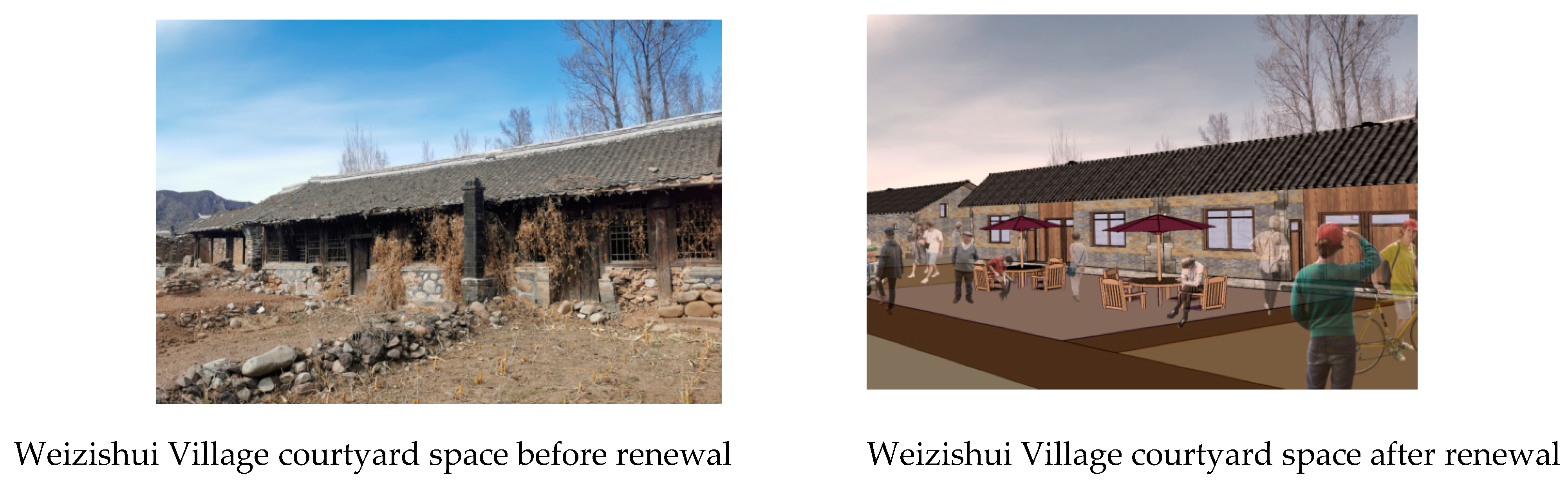
Secondly, whether the public spaces meet the villagers’ social needs is the core factor in judging their effectiveness [45]. Integrating the local needs of villagers into the construction of public spaces can enhance the spiritual culture of villagers, strengthen the cohesion between villagers, and help the reconstruction of villages and the formation of village communities. In order to emphasize the complexity of public spaces, a variety of public spaces with pleasant scale, diverse functions, and complementary contents ought to be evenly arranged in the settlement to facilitate the collective activities of villagers from different areas. Different degrees of openness should be adopted to meet the needs of different users and stimulate the participation of villagers. For example, as shown in Figure 8, the courtyard space commonly used by villagers in Weizishui Village can be further improved by removing debris, enhancing seat comfort, setting a sunshade roof, planting green plants, and increasing night lighting to further enhance the spatial quality of the node.
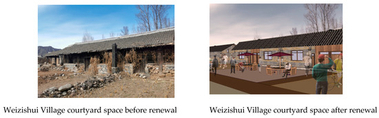
Figure 8.
Comparison of courtyard space optimization in Weizishui Village.
At the same time, the problem of identifying points with low centrality ranking can be solved, thus increasing the utilization of the village space. Paying attention to the vacant space and using the path that the center space must take as an intermediary, important functions are added to turn the vacant space into a node. As shown in Figure 9, the open space within the site, which is currently in a deserted state, will be transformed into a market square space with a unified shade structure. This will create a comfortable business environment and standardize the business regime to serve residents and visitors.
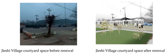
Figure 9.
Comparison of optimization of unused vacant land in Jieshi Village.
5. Conclusions
This study addresses the phenomenon of social structure change and mismatch between supply and demand of public spaces in traditional villages in the Mentougou Traditional Village Protection Demonstration Area in Beijing. Based on the close correlation between the spatial configuration of public space and the morphological pattern of the villages, Liulichu Village in regimented form, Jieshi Village in linear form, and Reedshui Village in dispersed form were taken as the objects of study. The quantitative tools of social network theory were used for data-based analysis to explore the topological relationship of the village public spaces network model. The results of the analysis show that the strategies for public spaces in traditional villages of different forms should focus on their spatial characteristics. The density indicator of dispersed-form traditional villages is obviously lower than the standard value, and the planning decision should be inclined to optimize the correlation of spatial network structure; the villagers’ use demand of clustered-form traditional villages is obviously unmet, based on the results of the centrality indicator, so the focus should be on increasing the number of spatial nodes and transforming the spatial functions in order to achieve higher equilibrium; and the linear-form traditional villages should enhance the direct connection between public spaces and reduce network vulnerability.
The traditional village model constructed by a social network space provides ideas for the gridding of village space [46]. As summarized by the above research, there are still a large number of other traditional villages in China that have similar morphological structures to Liuliqiu Village, Jieshi Village, and Reizishui Village. They also have similar problems such as the decay of public space. Therefore, this paper takes traditional villages as the target and the characteristics of traditional villages in different forms as the research object. It focuses on discovering, excavating, and refining public space elements to add new contents to the renewal strategies of traditional villages of each form and enrich the research framework of public space renewal. Focusing on the construction of village public space networks is conducive to improving the utilization rate of village public space and enhancing villagers’ sense of belonging and identity. This can better promote interaction between villagers and prevent the gradual loss of the village’s authenticity in the midst of diversified development. At the same time, it provides a new exploration direction for the practice of rural revitalization. However, due to the fact that the current study is relatively limited to the existing conditions, there is a lack of consideration of the longer-term and stage-by-stage development goals for the future. For example, there are potential challenges in obtaining support and funding from the government, changing the awareness of villagers’ groups about the protection of public space, and the question of how to maintain public space facilities in the future. The operationalization and replicability of this project is still relatively insufficient and should be the focus of future discussions.
With the accelerated pace of the construction of traditional villages, the construction of spatial networks at the academic level will become more mature, and the exploration of refined spatial network elements, evolution process, and optimization strategy will be more abundant. At the practical level, it will help promote urban–rural integration, achieve rural revitalization, eliminate the urban–rural gap, and lay the foundation for the sustainable development of traditional villages. The optimization of public spaces in traditional villages under the perspective of social networks will have more academic and practical value.
Author Contributions
Q.L.: conceptualization, methodology, formal analysis, writing—original draft, writing—review and editing. S.L.: methodological analysis, writing—original draft. J.C.: formal analysis, writing—original draft. Y.L.: writing—review and editing, guidelines. Z.C.: editing, formatting adjustments. All authors have read and agreed to the published version of the manuscript.
Funding
This research was funded by the Beijing Municipal Society of Higher Education, MS2022276; Beijing Municipal Education Science “13th Five-Year Plan” 2019 Project, CDDB19167; China Construction Education Association, 2019061.
Institutional Review Board Statement
Not applicable.
Informed Consent Statement
Not applicable.
Data Availability Statement
The original contributions presented in the study are included in the article, further inquiries can be directed to the corresponding authors.
Conflicts of Interest
The authors declare no conflicts of interest.
References
- Pete, J.B.; Jayne, C. Combining complexity-framed research methods for social research. Int. J. Soc. Res. Methodol. 2022, 25, 835–848. [Google Scholar]
- Vivant, E. Experiencing research-creation in urban studies. Lessons from an inquiry on the making of public space. Cities 2018, 77, 60–66. [Google Scholar] [CrossRef]
- Murray, J.; Dhami, K.M.; McClatchey, K.; Cohen, W.L.; Ayton, P. Health, Wellbeing, and Social Interaction: An International and Demographic Analysis of Perceived Life Changes and the Positives and Negatives of the COVID-19 Lockdown. Eur. J. Psychol. 2023, 19, 143–157. [Google Scholar] [CrossRef] [PubMed]
- Sun, Q. The Reconstruction Strategy of Rural Public Space in Zhaoqing under the Background of Rural Revitalization. Acad. J. Humanit. Soc. Sci. 2023, 6, 142–147. [Google Scholar]
- Zhao, G.; Weng, Y.; Chen, Z. Comprehensive Evaluation of Public Space in Urban Villages from the Perspective of Social Network: A Case Study of Tangxia Village in Guangzhou. In Proceedings of the 10th International Conference on Social Science, Education and Humanities Research, Paris, France, 17–18 December 2022; Francis Academic Press: London, UK, 2022. [Google Scholar]
- Stefani, D.; Mondada, L. Encounters in Public Space: How Acquainted Versus Unacquainted Persons Establish Social and Spatial Arrangements. Res. Lang. Soc. Interact. 2018, 51, 248–270. [Google Scholar] [CrossRef]
- Herrera-Yagüe, C.; Schneider, C.M.; Couronné, T.; Smoreda, Z.; Benito, R.M.; Zufiria, P.J.; González, M.C. The anatomy of urban social networks and its implications in the searchability problem. Sci. Rep. 2015, 5, 10265. [Google Scholar] [CrossRef]
- Agnieszka, S.; Katarzyna, P. An Evaluation of Public Spaces with the Use of Direct and Remote Methods. Land 2020, 9, 419. [Google Scholar]
- Yang, I.; Horak, S. Emotions, indigenous affective ties, and social network theory—The case of South Korea. Asia Pac. J. Manag. 2019, 36, 395–414. [Google Scholar] [CrossRef]
- Xiaomeng, W.; Zhilin, L. Neighborhood environments and inclusive cities: An empirical study of local residents’ attitudes toward migrant social integration in Beijing, China. Landsc. Urban Plan. 2022, 226, 104495. [Google Scholar]
- Chunla, L.; Mei, X. Characteristics and Influencing Factors on the Hollowing of Traditional Villages—Taking 2645 Villages from the Chinese Traditional Village Catalogue (Batch 5) as an Example. Int. J. Environ. Res. Public Health 2021, 18, 12759. [Google Scholar]
- Li, L.; Li, L.; Wei, L. Research on Rural Public Space Reconstruction for the aged from the Perspective of Community Endowment—Taking Jinqiao village in Fengyang as an Example. IOP Conf. Ser. Earth Environ. Sci. 2020, 525, 012076. [Google Scholar] [CrossRef]
- Li, Z. A Study on Protection and Renewal Planning of Tourism-Based Rural Settlements in Southern Jiangsu Based on Social Network Analysis; Suzhou University of Science and Technology: Suzhou, China, 2021. (In Chinese) [Google Scholar]
- Huili, X.; Liyuan, H. Comparative Analysis of Urban and Rural Public Space Environment Design Based on Multimedia Information. Adv. Multimed. 2022. [Google Scholar] [CrossRef]
- Zhang, D.; Shi, Z.; Cheng, M. A Study on the Spatial Pattern of Traditional Villages from the Perspective of Courtyard House Distribution. Buildings 2023, 13, 1913. [Google Scholar] [CrossRef]
- Nan, B.; Pirouz, N.; Ana, R.P.; Raoul, B.; Weixin, H.; Lu, W. Investigating rural public spaces with cultural significance using morphological, cognitive and behavioural data. Environ. Plan. B Urban Anal. City Sci. 2023, 50, 94–116. [Google Scholar]
- Chao, W.; Miaomiao, C.; Lei, Z.; Xiaojin, L.; Wei, W. Identifying the Spatiotemporal Patterns of Traditional Villages in China: A Multiscale Perspective. Land 2020, 9, 449. [Google Scholar]
- Ocampo, G.B.S.; Puente, D.M.J. Social Network Analysis Uses and Contributions to Innovation Initiatives in Rural Areas: A Review. Sustainability 2023, 15, 14018. [Google Scholar] [CrossRef]
- Xiao, S.; Hongxiao, L.; Chuan, L.; Huifu, N.; Peng, Y. Understanding recreational ecosystem service supply-demand mismatch and social groups’ preferences: Implications for urban–rural planning. Landsc. Urban Plan. 2024, 241, 104903. [Google Scholar]
- Ma, X. Early Chinese Village Patterns in Terms of the Origin of Civilization in China. Soc. Sci. China 2021, 42, 44–60. [Google Scholar]
- Yi, Z.; Ding, J. Renewal Strategy of Traditional Rural Public Space in Southern Jiangsu Based on SNA. Urban For. China 2022, 20, 108–113. (In Chinese) [Google Scholar]
- Yuan, M.; Kang, J.L.; Chan, D.K. A Study on the Traditional Color Analysis of Chinese Historic Village—Focus on Cuandixia Village of Mentougou District in Beijing. J. Korean Inst. Tradit. Landsc. Archit. 2015, 33, 112–128. [Google Scholar]
- Ministry of Housing and Urban-Rural Development of the People’s Republic of China. Public Announcement of the List of Demonstration Counties (Municipalities and Districts) for Concentrated and Continuous Protection and Utilisation of Traditional Villages in 2022. Available online: https://www.mohurd.gov.cn/xinwen/gzdt/202203/20220330_765382.html (accessed on 30 July 2022).
- Wei, D.; Yani, Y.; Yu, D. Village morphology and the construction of place identity in the Aihui area along the Heilongjiang River, China. River Res. Appl. 2022, 39, 1328–1341. [Google Scholar] [CrossRef]
- Yang, M.H.; Zhang, Y.C.; Liang, T.R.; Tian, F. Set Pair Social Network Analysis Model. Appl. Mech. Mater. 2011, 1156, 63–67. [Google Scholar] [CrossRef]
- Yujie, J.; Ni, L.; Ziyue, W. Parametric Reconstruction of Traditional Village Morphology Based on the Space Gene Perspective—The Case Study of Xiaoxi Village in Western Hunan, China. Sustainability 2023, 15, 2088. [Google Scholar]
- Lin, J.; Cai, J.; Han, F.; Han, Y.; Liu, J. Underperformance of Planning for Peri-Urban Rural Sustainable Development: The Case of Mentougou District in Beijing. Sustainability 2016, 8, 858. [Google Scholar] [CrossRef]
- Lichun, J.; Sheng, J. Research on the Structure and Formation Mechanism of Public Space in Traditional Villages Based on Graph Theory. Planners 2019, 35, 52–57. (In Chinese) [Google Scholar]
- Aude, K. Actors interaction in organisations for integration: Dependency, strategy and misappropriation. The relationship between women from working-class area and institutions. Auton. Locali E Serv. Soc. 2013, XXXVI, 55–74. [Google Scholar]
- Suyuan, H.; Weiye, W. Social Resources Transfer Program under China’s Targeted Poverty Alleviation Strategy: Rural Social Structure and Local Politics. J. Contemp. China 2023, 32, 686–703. [Google Scholar]
- Gavgani, Z.V.; Jaafarzadeh, R.; Khodapanah, T. A Review of the Principles of Social Networks Analysis and Co-authorship Networks. Taṣvīr-I Salāmat 2016, 7, 61–66. [Google Scholar]
- Xiao, X.; Tang, C.; Liang, W. Spatial Distribution and Cultural Features of Traditional Villages in Beijing and Influencing Factors. J. Resour. Ecol. 2022, 13, 1074–1086. [Google Scholar] [CrossRef]
- Yongzhen, W.; Xianzhong, C. Village Evaluation and Classification Guidance of a County in Southeast Gansu Based on the Rural Revitalization Strategy. Land 2022, 11, 857. [Google Scholar]
- Euijin, H.; Reuben, K.; Kevin, M.; Ahmed, K.; Patrick, O. Sketching dialogue: Incorporating sketching in empathetic semi-Structured interviews for human-computer interaction research. Behav. Inf. Technol. 2023, 42, 2226–2254. [Google Scholar]
- Ortega, V.M.; Díaz, C.M.M.; Lozano, M.J.J. Perceptions and characteristics of public space and urban environment among city inhabitans in Cúcuta-Colombia. Prospectiva 2016, 21, 213–239. [Google Scholar] [CrossRef]
- Savio, D.R.M.; Sankar, A.; Vijayarajan, R.N. A Novel Enumeration Strategy of Maximal Bicliques from 3-Dimensional Symmetric Adjacency Matrix. Int. J. Artif. Intell. 2014, 12, 42–56. [Google Scholar]
- Sun, S.; Zhou, M. Analysis of farmers’ land transfer willingness and satisfaction based on SPSS analysis of computer software. Clust. Comput. J. Netw. Softw. Tools Appl. 2019, 22, 9123–9131. [Google Scholar] [CrossRef]
- Camacho, D.; Panizo-LLedot, Á.; Bello-Orgaz, G.; Gonzalez-Pardoet, A.; Cambriaal, E. The four dimensions of social network analysis: An overview of research methods, applications, and software tools. Inf. Fusion 2020, 63, 88–120. [Google Scholar] [CrossRef]
- Júlia, A.P.; Antoni, R. Public Space Networks as A Support for Urban Diversity. Open House Int. 2012, 37, 15–23. [Google Scholar]
- Tai, S.; Zhang, Y.; Li, T. Factors affecting BIM application in China: A social network model. J. Eng. Des. Technol. 2021, 19, 373–384. [Google Scholar] [CrossRef]
- Lipeng, C.; Yaoming, C. Research on Traditional Village Protection Based on Value Evaluation. Sci. Discov. 2019, 7, 291–298. [Google Scholar] [CrossRef]
- Zimeng, K.; Xinyue, L.; Siming, L. An Exploration of Grey Spatial Intentions in Rural Public Space. Hous. Real Estate 2019, 12, 225. (In Chinese) [Google Scholar]
- Huang, D.; Zhang, N.; Zhang, Y. Traditional Village Landscape Identification and Remodeling Strategy: Taking the Radish Village as an Example. Mob. Inf. Syst. 2022, 2022, 2350310. (In Chinese) [Google Scholar] [CrossRef]
- Hua, X.; Tianhang, Z.; Beichen, G.; Yuhong, S. Developing of rural settlement landscape gene research system based on content analysis. J. Asian Archit. Build. Eng. 2023, 22, 2839–2850. [Google Scholar]
- Zheng, J.; He, J.; Tang, H. The Vitality of Public Space and the Effects of Environmental Factors in Chinese Suburban Rural Communities Based on Tourists and Residents. Int. J. Environ. Res. Public Health 2023, 20, 263. [Google Scholar] [CrossRef] [PubMed]
- Lin, Y. Research on Organization Network Model for Construction Project Based on Social Network Analysis. Appl. Mech. Mater. 2012, 1801, 2001–2005. [Google Scholar] [CrossRef]


Disclaimer/Publisher’s Note: The statements, opinions and data contained in all publications are solely those of the individual author(s) and contributor(s) and not of MDPI and/or the editor(s). MDPI and/or the editor(s) disclaim responsibility for any injury to people or property resulting from any ideas, methods, instructions or products referred to in the content. |
© 2024 by the authors. Licensee MDPI, Basel, Switzerland. This article is an open access article distributed under the terms and conditions of the Creative Commons Attribution (CC BY) license (https://creativecommons.org/licenses/by/4.0/).