Article

Assessing Subjective and Objective Road Environment Perception in the Bangkok Metropolitan Region, Thailand: A Deep Learning Approach Utilizing Street Images

1
Center of Excellence in Urban Mobility Research and Innovation, Faculty of Architecture and Planning, Thammasat University, Bangkok 12120, Thailand
2
Department of Computer Engineering, Faculty of Engineering, Chulalongkorn University, Bangkok 10330, Thailand
3
Department of Civil Engineering, Meijo University, Nagoya 468-8502, Japan
4
Center for Sustainable Development and Global Smart City, Chubu University, Kasugai 487-8501, Japan
5
Department of Computer Science, Chubu University, Kasugai 487-8501, Japan
*
Author to whom correspondence should be addressed.
Sustainability 2024, 16(4), 1494; https://doi.org/10.3390/su16041494
Submission received: 16 November 2023 / Revised: 25 January 2024 / Accepted: 7 February 2024 / Published: 9 February 2024
(This article belongs to the Section Sustainable Transportation)

Abstract

:
Recently, deep learning techniques, specifically semantic segmentation, have been employed to extract visual features from street images, a dimension that has received limited attention in the investigation of the connection between subjective and objective road environment perception. This study is dedicated to exploring and comprehending the factors influencing commuters’ perceptions of the road environment, with the aim of bridging the gap in interpreting environmental quality in Thailand. Semantic segmentation was applied to identify visual objects, expressed as a percentage of pixels represented in 14,812 street images from the Bangkok Metropolitan Region. Subjective road environment perception was assessed through a questionnaire, with a total of 3600 samples collected. Both sets of data were converted to average values per grid, with a grid size of 500 × 500 square meters, resulting in a total of 631 grids with data points. Finally, a multiple linear regression model was employed to analyze the relationship between the ratios of objects obtained from street images via semantic segmentation and human sensory perception of the road environment. The findings from this analysis indicate that the attributes of distinct object classes have a notable impact on individuals’ perceptions of the road environment. Visual elements such as infrastructure, construction, nature, and vehicles were identified as influential factors in shaping the perception of the road environment. However, human and object features did not exhibit statistical significance in this regard. Furthermore, when examining different road environments, which can be categorized into urban, community, and rural contexts, it becomes evident that these contexts distinctly affect the perceptions of various road environments. Consequently, gaining a comprehensive understanding of how street environments are perceived is crucial for the design and planning of neighborhoods and urban communities, facilitating the creation of safer and more enjoyable living environments.

1. Introduction

Over the past few decades, the rapid urbanization in developing countries has led to significant changes in the structural and functional complexity of cities as they strive to accommodate a growing population [1]. This transformation, particularly evident in the transportation sector, is a result of the urbanization process and encompasses various aspects, including the choice of transportation mode, urban traffic demand, and trip purposes. Numerous travel options have been developed to address these challenges, such as public transport, active transport, and para-transport. However, it is essential to note that the primary transportation system that has seen significant development is the road network, which serves as the most widely used mode of transportation, facilitating vehicle travel more extensively than any other mode [2]. The transportation network plays a vital role in providing essential connections that allow individuals access to a wide range of activities necessary for their daily lives. Moreover, it increasingly contributes to fostering social networks and promoting sustainable inclusive growth within society and the economy [3,4]. Beyond its primary function of connecting people, goods, and services, the perspective of urban road environment design and planning highlights the significance of designing road elements and the overall environment. This aspect becomes a vital consideration in enhancing the quality and value of the surrounding living neighborhoods and facilitating various dimensions, e.g., vitality, safety, comfort, aesthetics, etc. [5,6].
Many studies traditionally apply their assessment of the road and urban environment around physical data, primarily relying on GIS-based or POI-based datasets, as well as investigating people’s perceptions of these environments [5,7]. Nevertheless, recent technological advancements have seen an increase in the application of artificial intelligence analysis in transportation studies, particularly in the evaluation of road and urban environments. Deep learning technology has emerged as a powerful tool for assessing these environments, employing semantic segmentation of street imagery to enhance the comprehension of road and urban settings [2,8]. Significantly, addressing the limitations of street image analysis is crucial, especially given its gaps in accurately capturing and visually representing real on-site perceptions, which necessitate a sense of realism at the human scale. Consequently, this study aims to bridge these gaps by integrating the analysis of both subjective and objective factors, taking into account people’s perceptions. By incorporating street view images into the study, we seek to confirm the connection between people’s perceptions and the road environment [9,10]. However, existing studies still encounter challenges in terms of object detection within images, as the specific objects of interest may vary in different urban contexts or countries. Hence, our research is dedicated to exploring and comprehending the impact of the road environment on people’s perceptions, with the ultimate goal of narrowing the gap in interpreting environmental quality in Thailand. This region is characterized by its unique and diverse activities, making it an area of particular interest. The findings from this study will provide recommendations for environmental development that can better meet the needs of the people and enhance the quality of the road environment in the neighborhood, contributing to sustainable development.

2. Literature Review

2.1. Road Environment and Perception

Roads form an integral part of the built environment, connecting various urban levels, from neighborhoods and communities to urban centers. The composition of roads and their immediate surroundings holds significant implications for the perceptions of travelers and the residents living in proximity. A well-designed road and urban environment have the potential to infuse vitality into a community, enhance travel safety, convey the sense of being a suitable route for commuting, and contribute to aesthetics and cooling during travel, all while reducing stress [9,11]. Numerous studies have consistently confirmed the manifold benefits that a well-designed road environment can offer to a city, emphasizing the importance for urban planners and designers to prioritize this aspect. For example, studies on environmental matters, such as Xu et al. [12], emphasize that an increased urban road area ratio significantly reduces air pollution and an increased road network density reduces traffic emissions. This can be attributed to the availability of various alternative routes and diversified functional zones within the city, which help alleviate congestion. These options not only contribute to an enhancement in urban development efficiency but also counteract potential negative effects that might arise from expansive and wide roads. Regarding public health, research by Akgün-Tanbay et al. [5] suggests that a heightened perception of infrastructure for walking and cycling leads to improved safety perceptions. Liu et al. [13] have elucidated the influence of visual landscapes on road traffic safety, while Kang et al. [8] have indicated a growing trend in the use of street view images for assessing urban environments in public health studies. In the realm of urban design, Li et al. [10] employs panoramic street view images, virtual reality, and deep learning techniques to measure visual walkability perception. Additionally, the findings of Wang et al. [6] reveal a significant correlation between dynamic perception and street vitality.
The assessment of urban and road environments frequently relies on the measurement of both human and spatial perception, offering valuable insights into the actual experiences within these areas. This, in turn, assists city planners in identifying areas for improvement. Various indicators are influenced by human perception of street imagery, encompassing aspects such as vitality [6,14], safety [2,5,15], aesthetics [6,16], depression [9], wealth [9,16], boredom [9,16], greenness [15,17], and more. Each study, driven by its unique objectives, explores specific facets of these perceptions.

2.2. Assessment of Urban and Road Environments Perception

A substantial body of research has explored the assessment of road and urban environments. These studies have highlighted the significance of evaluating urban and road environments in the realm of urban design and planning. Nevertheless, this field of research continues to encounter challenges owing to the dynamic and intricate nature of cities, which vary considerably across different urban contexts, constituting an essential prerequisite for these investigations. In terms of techniques for measuring perception, it can be categorized into two primary components: the measurement of objects and subjective assessments. A limited number of studies have attempted to bridge the gap between human and spatial perception, endeavoring to reduce the disparity in research. For instance, Xu et al. [15] examined the relationships between streetscape perceptions, encompassing both subjective and objective measures, and property values. The objective component was determined through the utilization of street-view imagery, involving the extraction of physical features through a deep learning framework, while the subjective aspect was assessed via survey questions regarding street-scene perceptions. Qiu et al. [18] conducted an evaluation of large-scale urban perceptions, incorporating both subjective and objective elements. Nyunt et al. [19] examined measures of the neighborhood environment and their association with physical activity among older individuals. Here, the subjective measure was gauged through the perceived neighborhood environment, and the objective measure involved the application of GIS to assess an accessibility index. Furthermore, Yang et al. [20] explored the relationship between house prices and the urban environment, considering the role of both subjective perceptions and objective measurements.
An analysis of the existing literature and relevant research reveals that the most common method for gathering effective subjective measures is through surveys employing questionnaires, interviews, and on-site observations. These traditional tools are typically employed to assess subjective perceptions, including attributes of road and urban environments [21]. However, despite their effectiveness in data collection, these tools still raise concerns due to the potential for errors and biases stemming from human subjectivity. In terms of object-oriented data collection, information will be sourced from Geographic Information Systems (GIS) and Points of Interest (POI) databases. However, these data sources pose concerns regarding their currency due to their vast scale at the urban level, making it time-consuming and costly to maintain updated information promptly. Conversely, there is a paucity of scholarly endeavors that have explored the visual characteristics of road and urban environments through street view imagery, which has emerged as a valuable and convenient data source for collection. Exploring people’s subjective perception of objective environmental data presents a significant challenge. The evaluation of road and urban environment perceptions by combining these data types is relatively uncommon, and its limitations vary depending on the urban context. Each city possesses a distinct configuration of objects and infrastructures, particularly in the design and placement of various elements within streets and along roadsides. These disparities influence commuters’ perceptions to a significant extent. In Thailand, the incorporation of both dimensions, coupled with the application of deep learning, presents as an underexplored issue that requires a more comprehensive understanding and investigation.

2.3. Applying Street Images and Deep-Learning Technique for Urban and Road Environments Perception

In recent times, street images have introduced an alternative dimension for recognizing urban physical features and have proven invaluable in evaluating urban and road environments based on the objects contained within these images. Street images have the capacity to intuitively and accurately depict the intricate details of various urban elements including roads, sidewalks, vehicles, people, buildings, and more [22,23]. These advantages position street view imagery as a crucial data source for research in urban environmental assessment, offering the ability to represent the visual characteristics of road and urban environments, encompassing dynamic objects such as vehicles and people, as well as static objects like roads, buildings, and vegetation. The availability of street-level image data, coupled with advanced deep learning algorithms, has revolutionized the perception and comprehension of road and urban environments. This transformation is achieved through image processing and semantic interpretation, encompassing the classification of visual elements and the representation of scene features within images [24,25]. For instance, Nagata et al. [26] highlight the application of the semantic segmentation method, which facilitates the quantification of streetscapes. Kang et al. [8] also conduct a comprehensive review on the utilization of street view images for sensing urban environments, discussing the associated methodologies for image processing and semantic understanding. In a similar vein, Liu et al. [27] employ semantic segmentation techniques to analyze street view images. Wang et al. [28] employed deep learning through semantic segmentation in conjunction with space syntax to gauge residents’ perceptions of city streets.
However, the comprehensive evaluation based on commuters’ perceptions varies depending on the urban context [29]. Qin et al. [30] utilized image semantic segmentation techniques to extract road features, enabling the exploration of a speed decision model based on visual road information. In a similar vein, Wang et al. [31] applied street view imagery alongside deep learning techniques to investigate neighborhood perception and its relationship with physical activity. Their findings revealed significant associations between the terms “safe” and “depression” and the levels of physical activity. Dai et al. [32] utilized street-view images and deep learning techniques to examine the correlation between visual space and residents’ psychology. Additionally, Qi et al. [14] conducted an investigation into the visual features contributing to urban street vitality through the application of modern machine learning. To clarify the relationship between commuters’ perceptions and the characteristics of the built environment, a comprehensive understanding is imperative. A review of research that employs semantic segmentation reveals that objects represented in an image can be categorized into six primary components: infrastructure (e.g., roads and sidewalks), vehicles (e.g., cars, bicycles, motorcycles, trucks, etc.), constructions (e.g., buildings, walls, and fences), objects (e.g., poles and traffic signs), natural elements (e.g., vegetation), and humans (e.g., pedestrians). The significance of each object varies across different studies, necessitating a deeper understanding in the context of evolving urban environments.

3. Data and Methods

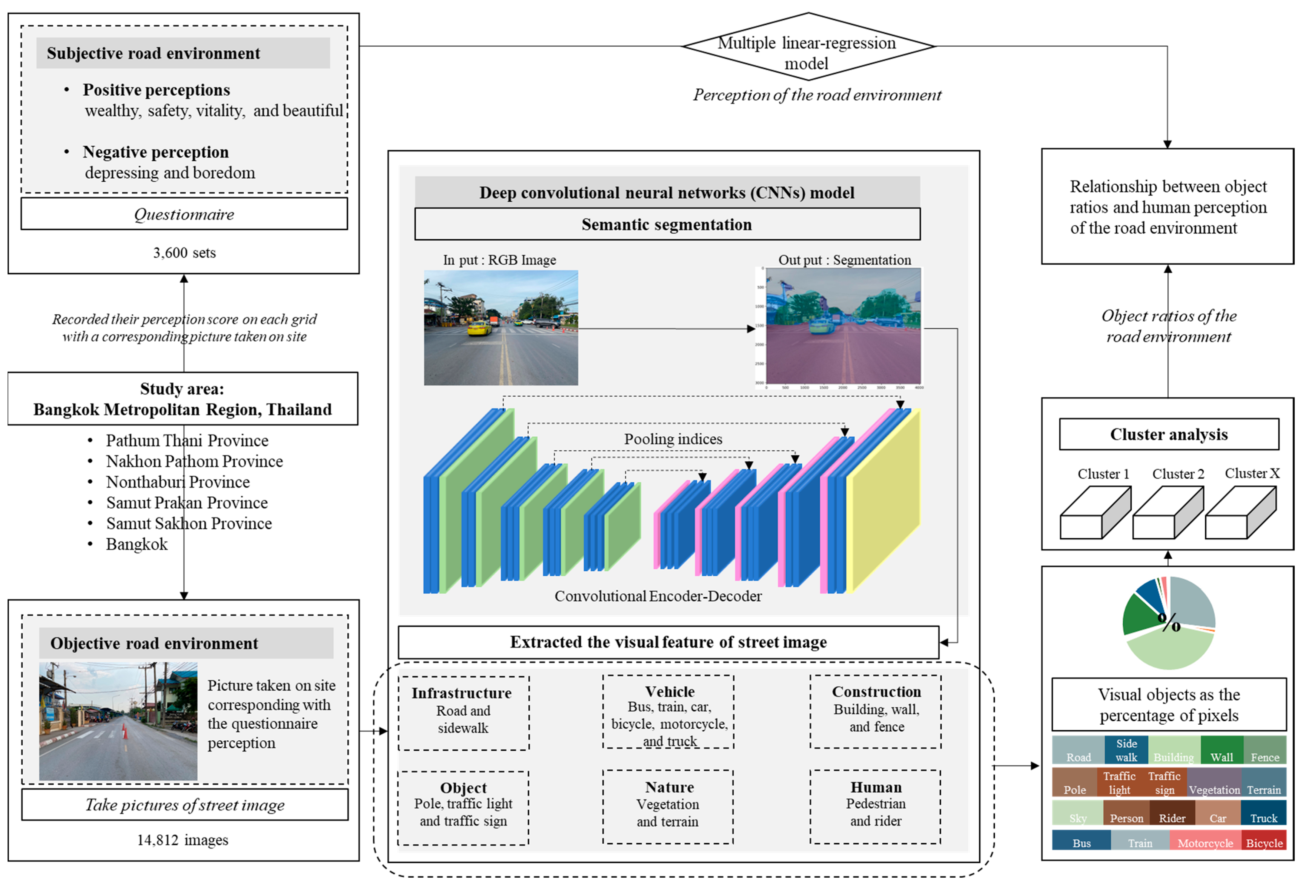
3.1. Analytical Framework

The extent to which subjective and objective environmental measures, through the integration of both dimensions and the application of deep learning, remain an underexplored issue and their potential complementarity is not explicitly articulated in the specific context of road environment perception in Thailand. This necessitates a more comprehensive investigation as depicted in Figure 1. While some studies have previously attempted to address this issue, the inherent variations in the context of road and urban environments, as well as the perspectives of residents in each country, make it challenging to directly apply the findings from other areas. This difficulty in cross-application hinders the successful design and planning of interventions that are responsive to the unique needs of residents due to disparities in the surrounding contexts.
Therefore, the objective of this study is to incorporate additional micro-scale urban perception data by establishing relationships for exploration and understanding. The study hypothesizes that objective road environment factors influence people’s perceptions of various emotions. In order for the study’s results to accurately reflect the diverse contexts of both road and urban environments, it is imperative to carefully choose a study area that can capture the wide-ranging travel patterns and urban landscapes. This ensures that attitudes and perceptions toward road elements accurately mirror the variations present in each distinct context. Consequently, this study outlines a specific spatial scope, and the selection of the Bangkok Metropolitan Region (comprising six provinces) is considered appropriate. This area encompasses a spectrum ranging from highly urbanized settings to rural landscapes in agricultural areas situated on the outskirts of the city. Furthermore, the selected study area boasts a diverse range of transportation modes, surpassing those found in other Thai provinces. These modes include rail mass transit, public buses, para-transportation, and more, providing a comprehensive representation of travel options available to the local populace. Figure 1 illustrates the workflow of the study. Firstly, the study focuses on the objective road environment by capturing images of the road environment and subsequently analyzing them to discern the individual elements present. The utilization of deep convolutional neural networks (CNNs) is employed for the classification of street images. Secondly, the study explores the perception of the road environment by gathering data on perceptions, with factors determined by individuals residing in proximity to the filming area. This approach ensures that the perception data are closely linked to the genuine perceptions of the road environment. Finally, the investigation explores the relationship between object ratios and human perceptions of the road environment. The specifics of data collection and analysis are elaborated as follows.

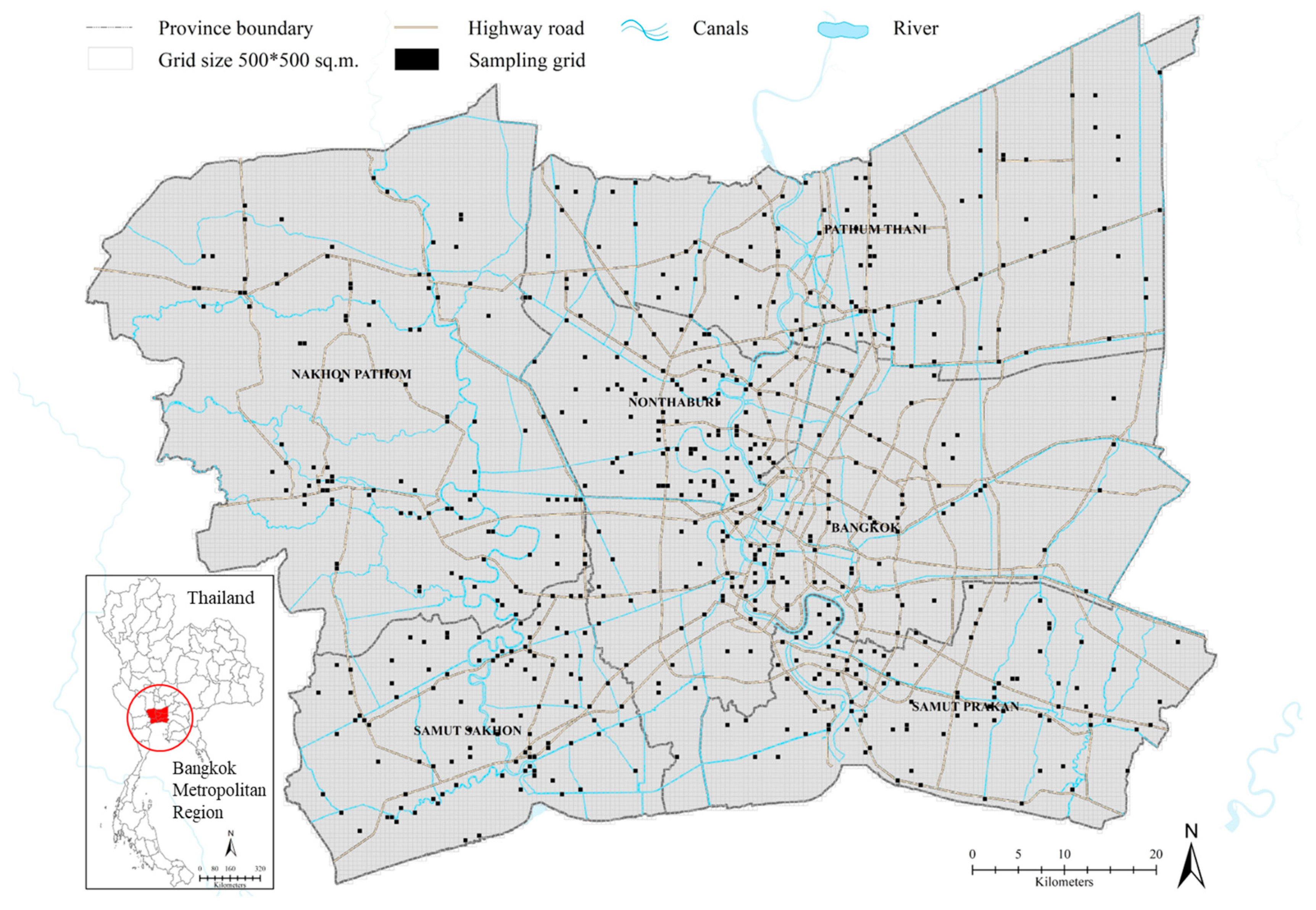
3.2. Study Area and Sampling Design

The study area for this research is the Bangkok Metropolitan Region, as depicted in Figure 2. Bangkok serves as the capital of Thailand and boasts a notably high population density and a wide range of diverse activities, with a population of at least ten million registered persons. The region has witnessed substantial development, leading to the expansion of activities into the surrounding provinces, collectively known as the metropolitan area. This metropolitan area comprises five provinces, which include Pathum Thani, Nakhon Pathom, Nonthaburi, Samut Prakan, and Samut Sakhon. The Bangkok Metropolitan Region encompasses an area of more than seven thousand square kilometers and accommodates a large population as a megacity. This region is renowned as the most economically prosperous zone in Thailand, serving as the epicenter for government, education, public health, and public administration. Perhaps most significantly, it holds the position of being Thailand’s economic hub, contributing to 50 percent of the nation’s gross domestic product. Given this context, the development of fundamental urban infrastructure is remarkably diverse. In particular, transportation-related infrastructure and services offer a wide array of travel mode options, catering to the population’s diverse needs. Nevertheless, it is essential to note that the quality and availability of travel options can significantly vary from one area to another.
Figure 2 illustrates the study area boundaries and the specific locations where the data on road environment images and questionnaire responses were gathered. The data collection followed a planned grid approach to visually represent the spatial distribution of the collected data. The black grid signifies the designated data collection areas, as elaborated in the subsequent sections outlining the data collection process. For the sampling design, a purposive convenient sample of 3600 individuals in the Bangkok Metropolitan Region was selected. The respondents were required to have a minimum of 2 years’ experience in traveling within the area and on the roads within the data collection zone. This criterion aimed to ensure that their perceptions adequately reflected everyday travel experiences. The sample size was determined using Taro Yamane’s formula [33] for determining sample size, with 3263 samples as the minimum number of sample groups (confidence level at 98%). However, in this study, the number of collected questionnaires was increased to prevent discrepancies arising from incomplete questionnaire responses, resulting in a total of 3600 respondents.

3.3. Subjective and Objective Road Environment Data

This study incorporates two primary data components: road environment image data and road element environment perception data. The framework of data collection is demonstrated in Figure 3 and the specific details are as follows:
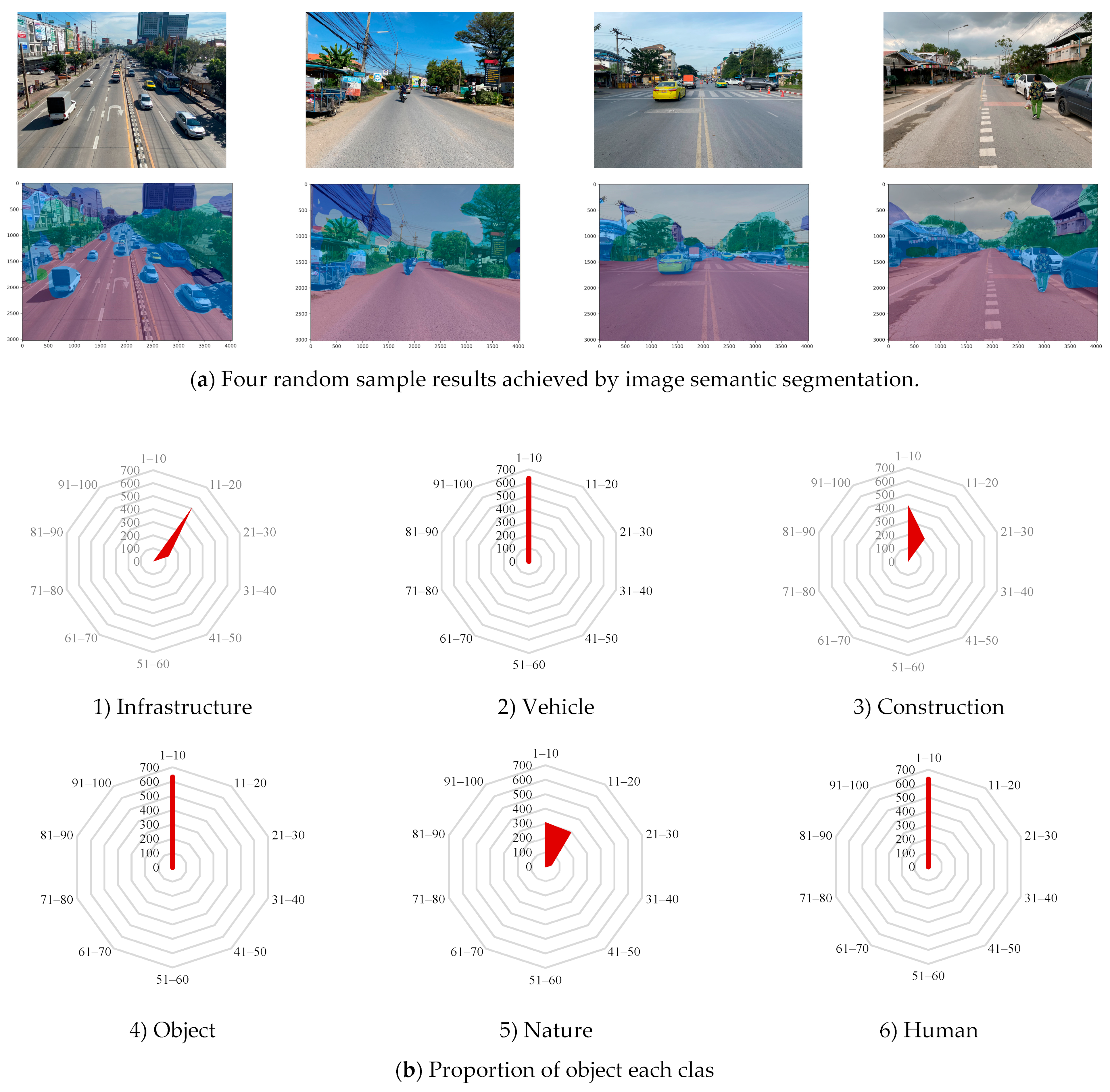
  • Road environment image data: This data is collected through extensive area surveys, involving the capture of photographs of the road environment. This study concentrates on the environmental perception of individuals residing in the vicinity of the surveyed road. The participants are both residents and individuals familiar with traveling under these conditions. The utilization of road imagery in analysis necessitates careful consideration of the analysis’s purpose to ensure the provision of the most comprehensive representation of the data. For instance, when investigating issues related to the walking and cycling environment, the visual perspective should emphasize infrastructure relevant to walking and cycling [34,35]. Consequently, the focused imagery captures the central segment of the road, providing a comprehensive view of the surroundings on both sides. Ensuring inclusivity of contextual details, such as sidewalks and bicycle paths, in the images is crucial. Additionally, apart from having a view from the center of the road, the quality of the images must be assessed to achieve optimal outcomes by excluding common issues such as poor lighting, sharpness, and inclement weather [35,36]. Therefore, in this study, images were captured under clear skies on a day with normal weather conditions, and the timing of capture coincided with travel, incorporating up-to-date information. The image data were thoroughly screened before undergoing analysis. This approach enables the images to mirror the road environment extensively, as illustrated in Figure 3. A total of 14,812 images were captured within the Bangkok Metropolitan Region (Nakhon Pathom (A1–A5), Nonthaburi (B1–B5), Pathum Thani (C1–C5), Bangkok (D1–D5), Samut Prakan (E1–E5), and Samut Sakhon (F1–F5)) during a specific time period for comparative analysis. The images were captured at the same location as the questionnaire data collection, depicting the real-time environment within the area at that particular moment. This contrasts with Google Street View images, as our data reflects the current conditions during the survey period.
Figure 3. Illustrative imagery featuring annotated data points within the Bangkok metropolitan region.
Sustainability 16 01494 g003
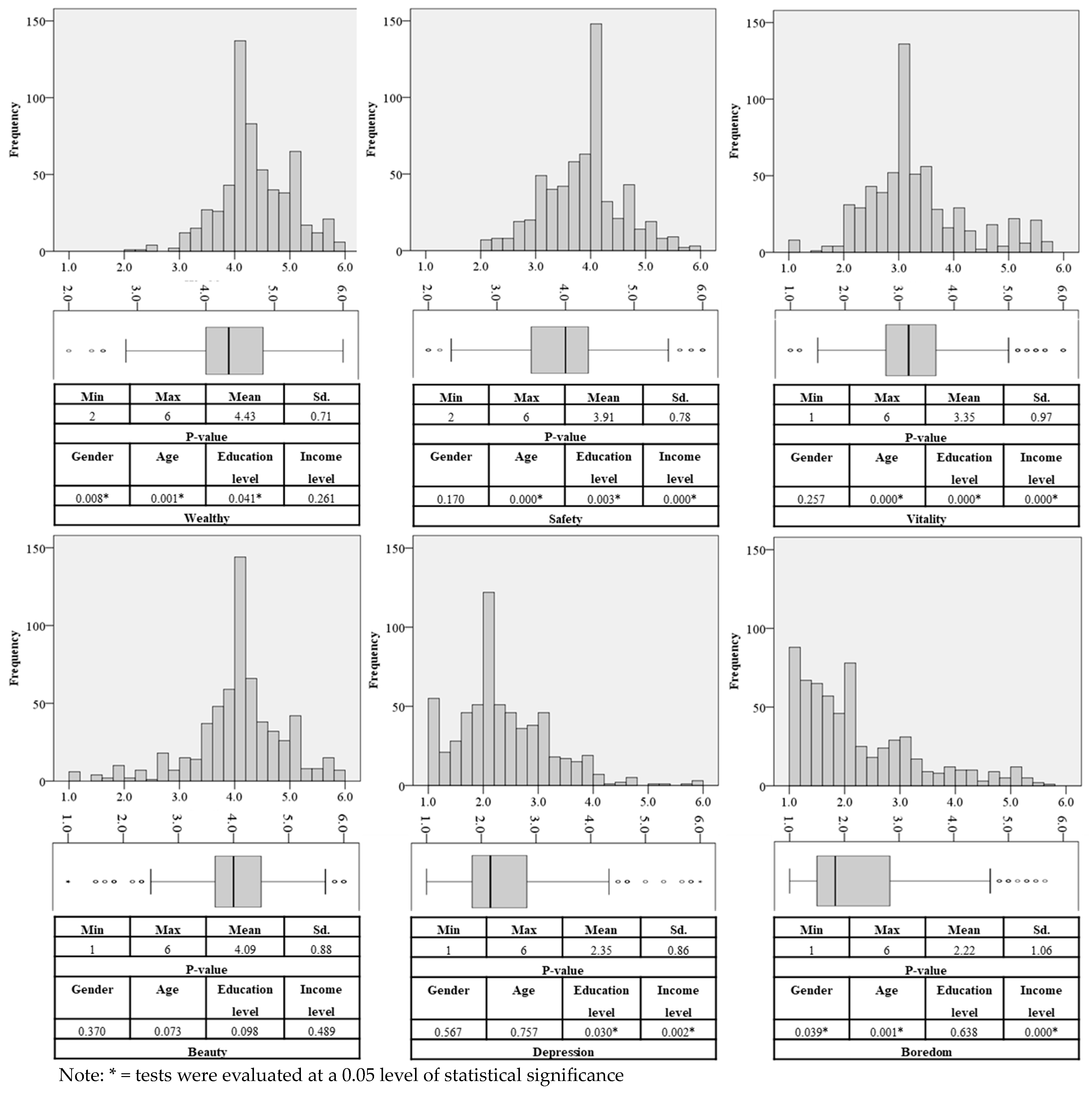
  • Perceptions of the road environment: Data were gathered through a questionnaire designed to assess individuals’ perceptions of the road environment. The questionnaire consisted of inquiries categorized into two main areas, comprising two parts: (1) questions related to the socio-economic characteristics of the sample, and (2) questions concerning the sample’s perception of the road environment, consisting of 6 items. This section encompasses positive perceptions, including notions of wealth, safety, vitality, and beauty, along with negative perceptions associated with feelings of depression and boredom. Commuters’ perceptions were measured on a 6-level scale, where 1 represented the lowest perception and 6 corresponded to the highest perceptibility. The questionnaire underwent meticulous design and refinement in close consultation with experts. Prior to collecting the actual data from the comprehensive questionnaire, a pilot study was conducted to assess the respondents’ understanding and to identify discrepancies in the questions. The questionnaire was then improved based on the feedback from the pilot study. Subsequently, the documents were submitted for human ethics consideration before commencing with data collection. The data were surveyed over a period of two months, from December 2022 to January 2023.

3.4. Data Collection

The questionnaire obtained ethical approval from the Human Research Ethics Committee of Thammasat University, specifically under No. 2 Social Sciences, with the approval number 146/2021. The consideration process guided the preparation of documents designed to assist volunteers to the greatest extent possible. Consequently, prior to commencing the interviews, volunteers underwent a screening process based on either the inclusion criteria or the specified qualifications for informants, ensuring that volunteers possessed the required qualifications. Subsequently, the information was explained to the participants of this research by providing an information sheet that outlined the origin and significance of data collection, the intended purpose, and the benefits accruing to the volunteers. This documentation should also address the confidentiality of the data collection process to mitigate any potential risks or impacts on the volunteers. Ultimately, consent was sought to utilize information from the volunteers, marking the commencement of the interview process.
The process of collecting image and perception data is outlined as follows: Firstly, an area grid with dimensions of 500 × 500 square meters is established, covering the entire study area. Secondly, the distribution of grid locations for data collection is intricately planned with a focus on four key criteria for selecting areas and capturing photos. (1) priority is given to days with clear skies and no rain, recognizing that image clarity significantly influences interpretation. (2) Spatial distribution is carefully considered in both urban and rural settings. (3) The chosen areas encompass regions near main, secondary, and local roads to provide a comprehensive view. (4) The selection includes areas with a variety of transportation modes, such as rail mass transit, public buses, sidewalks, and bicycle paths, alongside locations where alternative modes of travel are absent. This comprehensive approach aims to ensure that the collected images authentically reflect the diversity of the environment. Thirdly, the subsequent step involves the gathering of questionnaire data from a sample of individuals within the designated grid and capturing photographs of the road environment at survey points where people’s perceptions are assessed, as elucidated in Table 1. These images correspond to the specific areas where the questionnaire is administered. Therefore, a minimum of four images will be collected for roads of various ranks or different roads located in close proximity to the areas where the questionnaires are administered for each questionnaire. The collection of images and distribution of questionnaires were methodically dispersed across spatial grids to ensure comprehensive spatial coverage. Subsequently, after successfully entering the attribute data into the specified grid area, both datasets were averaged per grid, with each grid covering an area of 500 x 500 square meters. In total, data were collected from 631 grids located in Bangkok and its surrounding areas, as depicted in Figure 2. It is important to note that each grid encompasses a minimum of four questionnaires and at least 16 images.

3.5. Data Analysis

3.5.1. Image Semantic Segmentation and Deep Learning Technique

In this paper, we employed an AI-driven approach for data generation through a machine learning model based on the collected data. Specifically, we proposed the use of deep convolutional neural networks (CNNs) for street image classification, integrating scene classification with image semantic segmentation. Semantic segmentation, which involves deep learning techniques, was harnessed to compute visual features from street images [2,41]. This technique excels in accurately identifying various objects and quantifying the density of visual elements as a percentage of pixels present in street images. In the semantic segmentation process, we employed the open-source software package ‘PaddleSeg’, known for its high efficiency in image segmentation development [42,43]. The OCRNet model, utilizing HRNet_W48 as the selected backbone with the only super hyperparameter ‘backbone = HRNet_W48’, was implemented. The model was coded in Python and trained on the Cityscape dataset. The package included both of the pre-trained models and ensured high levels of accuracy. Consequently, this program is designed to be readily deployable, ensuring its effectiveness in recognizing the specified information. We extracted and quantified visual features from 14,812 street images in the Bangkok Metropolitan Region. The output of this process enables the representation of the proportion of various visual features in street images. These visual features can be categorized into six main classifications: infrastructure (e.g., roads and sidewalks), vehicles (e.g., buses, trains, cars, bicycles, motorcycles, and trucks), construction (e.g., buildings, walls, and fences), objects (e.g., poles, traffic lights, and traffic signs), nature (e.g., vegetation and terrain), and humans (i.e., pedestrians and riders), as demonstrated in Table 1.

3.5.2. Incorporating Additional Micro-Scale Urban Perception Data: Bridging the Gap between Subjective and Objective Road Environments

In the process of collecting road environment data through area grids, each grid comprising numerous questionnaires and images, the need arises to incorporate additional micro-scale urban perception data that bridges the gap between subjective and objective road environments. Consequently, employing the 6-level perceptual scales (ranging from 1 to 6, with scores reflecting low to high perception) and proportional values of objects within the images, these scales are transformed into averages per grid. This transformation converts the 6-level scales into continuous values, where those nearing one indicate lower perceptual values, and those approaching six represent the highest perceptual values. Therefore, the road environment image data can be correlated with individuals’ subjective perceptions of the road environment, as demonstrated by Iamtrakul et al. [2]. They assigned perception scores to each grid, complemented by an on-site picture. These road environment images depict the real-time conditions present during the questionnaire survey, conducted on the same day, time, and year, and at the identical location where the assessment of road environment perception took place.

3.5.3. Analysis of the Relationship between Objective Road Environment Factors and Individuals’ Perceptions of the Road Environment

After analyzing the segmentation of objects within the road environment images, the collected image data and perception data undergo a process to analyze their relationship, which is divided into two levels: (1) It considers the overall image at the area context level, taking into account different spatial contexts. In the grouping patterns based on spatial context, cluster analysis is employed, a data analysis technique exploring naturally occurring clusters within a dataset, referred to as clusters. Subsequently, upon obtaining information on the characteristics of these clusters, their features are considered in conjunction with the object visual feature classes within the image and the contextual characteristics of the area. Subsequently, we conducted a test to assess the differences in people’s average perceptions. This test operated under the assumption that the average perceptions of the environment vary across different area contexts. The objective of this analysis is to reveal distinct groups within the dataset of image elements, thereby emphasizing variations among these groups. (2) We considered the object visual feature classes at a more granular level. This step is crucial for quantifying the relationship between the visual features of street images and the perception of the road environment. As a result, the visual features extracted from the image data are utilized to evaluate their connection with the human sensory perceptions of the road environment. The selection of independent and dependent variables was based on the relevant literature (see Table 1). Independent variables encompass object visual feature classes categorized into six main classifications: infrastructure, vehicles, construction, objects, nature, and humans. On the other hand, dependent variables pertain to people’s perceptions of the road environment, are further divided into six dimensions: wealth, safety, vitality, beauty, depression, and boredom. The analytical approach involves the application of a multiple linear regression model to scrutinize the relationship between object ratios extracted from street images through semantic segmentation and the sensory perceptions of the road environment.

4. Results

4.1. Socio-Economic Characteristic of Respondents

In this study, data on the socio-economic characteristics of the respondents were collected to interpret the diverse socio-economic attributes within the study area, as depicted in Table 2. The majority of the sampled population constituted more than 68.5% females, while males comprised 31.1%. The average age of the participants was 38, with the predominant age groups being 25–34 years (36.2%) and 35–44 years (32.9%). Educational attainment revealed that over 92.3% held a bachelor’s degree, with high school education accounting for 3.7% and vocational college degrees for 2.8%. In terms of economic characteristics, more than 77.3% reported incomes ranging from 10,000 to 25,000 baht, followed by 25,001–40,000 baht, constituting 16.0%, and 40,000–55,000 baht accounting for 4.1%, respectively.

4.2. Road and Street Environment

Street images are examined to identify objects within the image via semantic segmentation. This process divides the image into six distinct elements, with each element further divided into two components (1) Information regarding the proportions of objects within the image, as illustrated in Figure 4b, is presented in a radar graph. The range of proportions is expressed in percentages, with each proportion being represented by the number of grids, and (2) Visualization through images, where the color matrix at the bottom signifies the semantic segmentation information of the extracted visual elements (as illustrated in Figure 4a).
On average, more than 18 percent of the objects in the images were related to infrastructure, with roads accounting for 33.2 percent and sidewalks for 2.9 percent. The second most prevalent group of objects in the images pertained to nature, constituting 11.2 percent, with the majority of these minor objects being vegetation, accounting for 20.6 percent. The third most common group of objects in the images was construction, with an average proportion of 8.1 percent. Within this category, the minor objects were predominantly buildings, accounting for 19.9 percent. The aspect ratio serves as an indicator of the proportion of objects within the image, aiding in the comprehension of diverse road environments based on object distribution. This aspect becomes particularly relevant when considering variations, such as the absence of green spaces or trees/bushes in certain images. Additionally, images captured in urban areas may exhibit distinct objects compared to those taken in rural areas. The examination of these specific details in relation to each other will be further explored in the subsequent section.

4.3. Perception of Road Environment

The factors utilized to assess the perceptions of the road environment are classified into six dimensions: wealth, safety, vitality, beauty, depression, and boredom. The outcomes, represented by the average values per grid of analysis, are depicted in Figure 5.
Analyzing the data from Figure 5, it becomes evident that among the positive aspects people perceived wealth ( x ¯ = 4.43) most prominently during their travels, followed by beauty ( x ¯   = 4.09), safety ( x ¯ = 3.91, and vitality ( x ¯ = 3.35). Regarding the negative aspects, individuals reported relatively low levels of pressure and boredom, with values ranging from 2.00 to 2.35. It is clearly seen that the estimated difference in the average perception scores, for both positive and negative, is statistically significant at a 99% confidence level. This suggests that individuals in the area are less likely to experience feelings of boredom or depression while traveling in an environment with abundant greenery and uncongested traffic. However, when considering variations in perception values alongside information on social and economic characteristics, it becomes evident that differences in these aspects contribute to distinct perceptions. For instance, variations in age, education, and income levels result in differing values for perceived safety and vitality. Meanwhile, differences in socio-economic characteristics showed no significant impact on perceived beauty values.
When examining the collective characteristics of the road environment through Cluster analysis, the image characteristics can be categorized into three clusters, as detailed in Figure 6. Each group reflects the urban community’s context in relation to the road environment, which is further elaborated upon in Figure 7, featuring the following details:
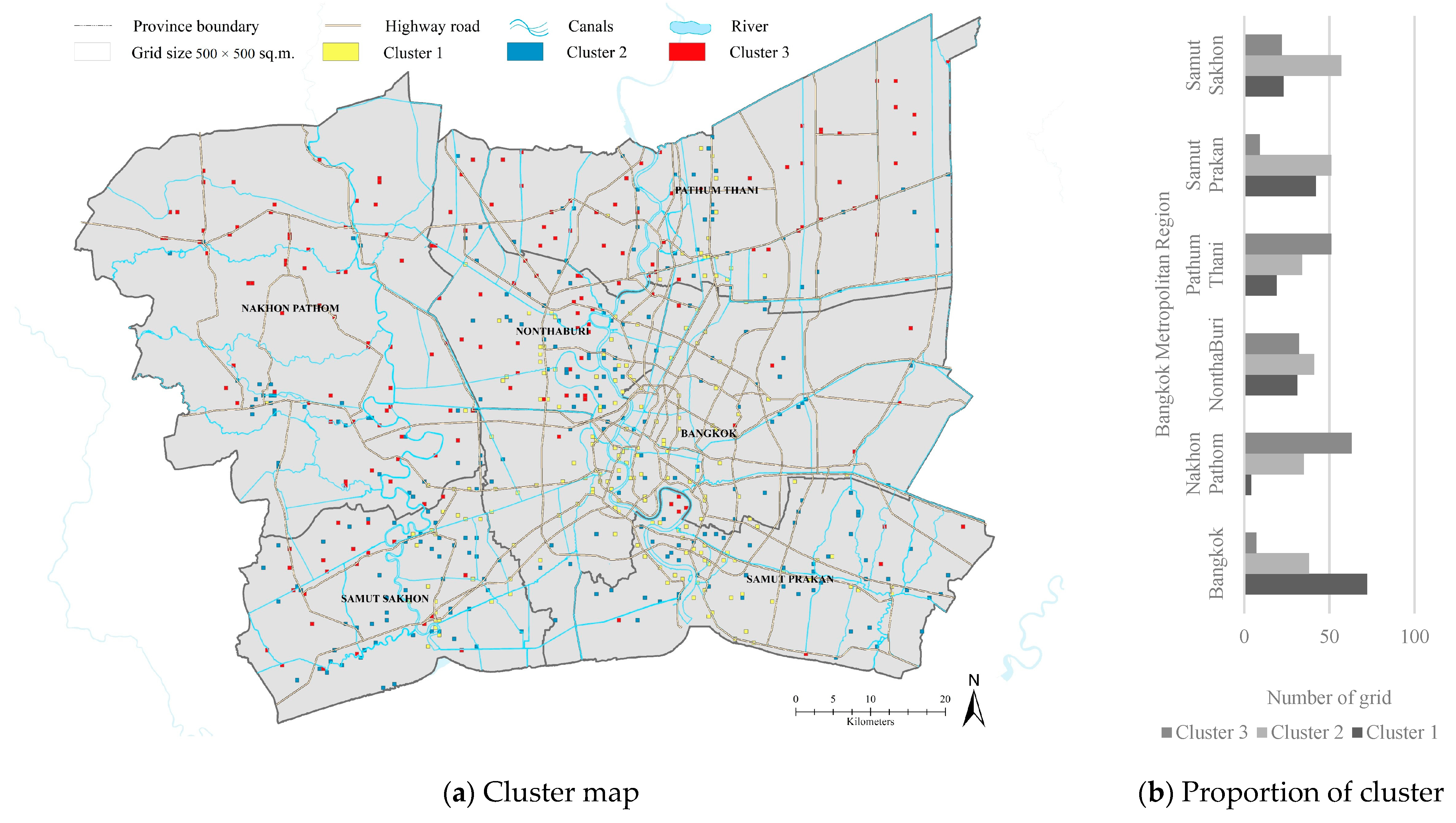
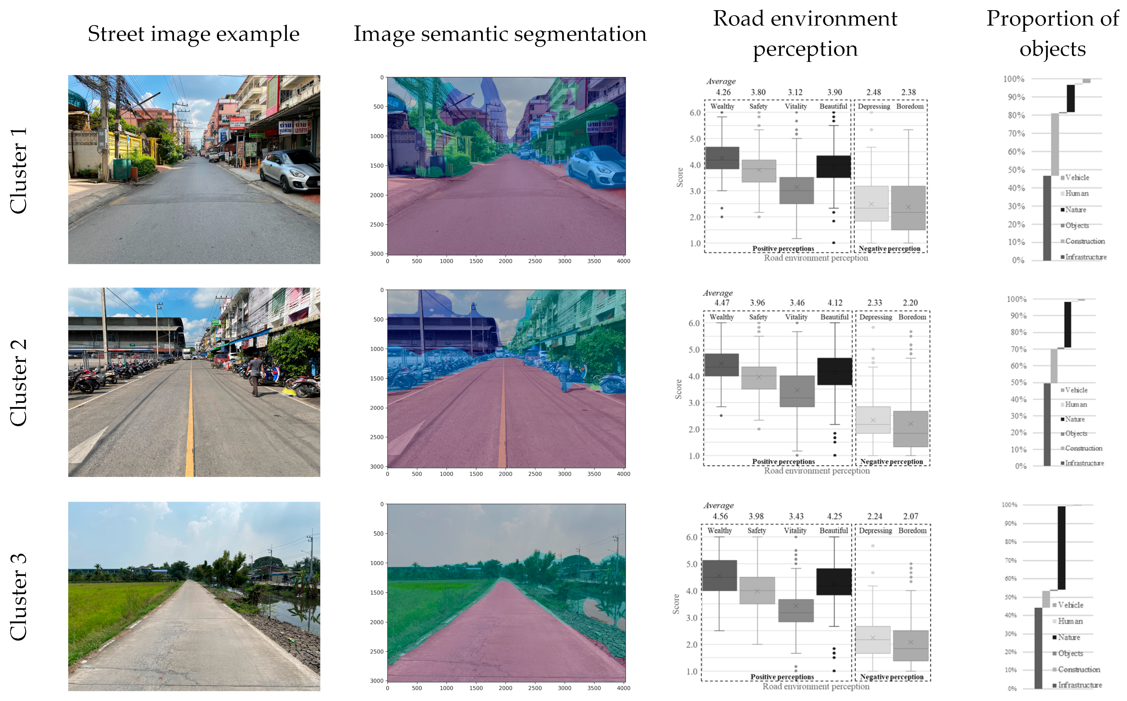
  • Cluster 1: The image’s location is depicted by the yellow grid. It was observed that the identified road environment clusters are situated within the urban regions of each province, characterized by high-density buildings and road infrastructure. Notably, Cluster 1 exhibits a higher proportion of prominent objects in the image, specifically buildings and roads, compared to the other clusters.
  • Cluster 2: The image’s location is indicated by the blue grid. The road environment clusters in this group are dispersed in regions situated at a distance from urban areas, yet still exhibiting a high density of activity. These areas feature a lower density of building and road infrastructure activities compared to Cluster 1, but they display a greater presence of vegetation than Cluster 1, although less than Cluster 3.
  • Cluster 3: The image’s location is denoted by the red grid. In this case, the identified road environment clusters are primarily situated within the suburban communities of each province, which are predominantly agricultural regions. These areas exhibit relatively low densities and limited activity variety. In this context, the road environment is predominantly characterized by vegetation rather than buildings.
Figure 6. Clusters of visual feature objects of road environments.
Sustainability 16 01494 g006
Figure 7. Clusters of visual feature objects of road environments and perceptions.
Sustainability 16 01494 g007
Taking into account the collective characteristics of the road environment, as illustrated in Figure 7, it is evident that groups characterized by a higher proportion of vegetation tend to report lower levels of boredom and feelings of depression compared to those with minimal vegetation and lower vibrancy in the road environment. In contrast, Cluster 1, distinguished by a significant presence of construction, infrastructure, and vehicles relative to other clusters, exhibits a reduced perception of safety and liveliness. Furthermore, it is also associated with a higher likelihood of generating feelings of depression and boredom during travel compared to the other clusters. Moreover, all perceptions of various clusters are statistically significant at a 99% confidence level, except for the perception of depression.

4.4. Perception of the Road Environment and Its Relationship

Following the identification of issues within the collective characteristics of the road environment and people’s perceptions, we conducted a series of statistical correlation tests to explore these relationships more comprehensively. As presented in Table 3, the analysis data reinforce our findings that various factors associated with road environment perception significantly impact individuals’ perceptions. It is evident that each factor related to the environment’s objects carries distinct implications for people’s perceptions. Based on the visual feature objects within the images, it was found that ‘wealth’ is notably influenced by “infrastructure” (B = 0.080 *) and “construction” (B = −0.038 *). In the context of “safety”, the visual feature objects that have a significant impact are “infrastructure” (B = 0.102 *) and “vehicle” (B = −0.176 *). “Vitality” is significantly influenced by “infrastructure” (B = 0.090 *). Lastly, “beauty” is significantly affected by “infrastructure” (B = 0.080 *) and “nature” (B = 0.057 *). In terms of negative perceptions, the visual feature objects within the images that significantly contribute to feelings of depression include ‘infrastructure’ (B = −0.070 *). Furthermore, ‘infrastructure’ (B = −0.113 *), ‘construction’ (B = −0.082 *), and ‘nature’ (B = −0.089 *) are all significant factors affecting the sensation of boredom.

5. Discussion

The analysis of the relationship between objective road environment factors and individuals’ perceptions of the road environment can be discussed in two parts. Firstly, the overall image is considered at the area context level, taking into account different spatial contexts. When examining distinct groups of road environments, which can be classified into urban, community, and rural contexts, these settings significantly influence perceptions of various road environments both positive and negative based on subjective and objective road environment considerations. The research highlights that different road environments, categorized as urban, community, and rural, exert a notable impact on individuals’ perceptions, encompassing both positive aspects (wealth, safety, vitality, and beauty) and negative aspects (depression and boredom). These perceptions are shaped by both subjective experiences and objective factors tied to the distinctive characteristics inherent in each context. Secondly, consider the object visual feature classes at a more granular level. The findings indicate that the characteristics of visual feature objects in distinct classes significantly impact individuals’ perceptions of the road environment. Visual features that impact road environment perceptions include “infrastructure”, “construction”, “nature”, and “vehicle”, while “human” and “object” features did not demonstrate statistical significance. The findings concerning ‘infrastructure’ (e.g., road and sidewalk) and “nature” (i.e., trees) are consistent with the study conducted by Li et al. [44], which emphasizes the significance of these visual feature objects in shaping perceptions of environmental safety.
Addressing the matter of travel safety perception, the study revealed a negative association with vehicles, aligning with the findings of Rita et al. (2023) [40]. Their study, utilizing street view imagery to assess safety among various user groups, found statistically significant negative correlations between cars and buses, cars and cyclists, and cars and pedestrians in a similar context. Few studies have explored the research on the effects of road environments on safety aspects, despite the notable impact that the design of roads and urban areas has on individuals’ perceptions. Examining the situation from a driver’s standpoint, the environment can significantly influence their behavior, manifesting in actions such as speeding, overtaking violations, and altered reaction times [45,46]. Shifting the focus to residents, residing in an unsuitable road environment can adversely affect their perception of safety, encompassing both travel and daily living experiences. The perception of unsafe conditions in the environment is likely to have a negative impact on the well-being of the residents.
With respect to depression, upon examining the environmental image data, it was observed that the absence of beautiful shady scenery and higher road traffic density were correlated with an increased perception of depression and boredom. This indicates another cognitive factor with a negative relationship, warranting attention from planners. The stress associated with travel can significantly impact individuals’ mental health, particularly during extended travel times in congested urban areas. Xu et al.’s [47] study, aiming to integrate street view images and deep learning to investigate the correlation between human perceptions of the built environment and cardiovascular disease, revealed an association between depression and vitality perceptions and the risk of cardiovascular disease. Thoughtfully designed urban spaces foster social cohesion, physical health, economic opportunities, and environmental sustainability. Conversely, poorly planned areas may contribute to issues such as social isolation, health risks, economic disparities, and the loss of green spaces. Striking a balance through inclusive sustainable urban planning is vital for creating environments that enhance well-being and community resilience. Notably, it is intriguing to note that “nature” exhibits a positive relationship with perceptions of beauty, while “vehicle” is negatively associated with safety perceptions.
Overall, recognizing this diversity is crucial for effective research, policy development, and urban planning tailored to the specific needs and challenges of different road environments. Consequently, comprehending how individuals perceive the urban environment is vital for designing and planning neighborhoods and urban communities that foster safer and more pleasant living environments, ultimately enhancing the well-being of city residents. This aligns with the findings of Long and Tang [22], which emphasize the strong positive impact of the quality of urban streets on residents’ well-being. While numerous studies have verified the effectiveness of street images and deep learning techniques, which propose the fusion of street view data and semantic segmentation methods for the accurate identification of objects within images and precise measurement on a human scale [9,13,24,48], it is crucial to recognize that the efficacy of deep learning tools is contingent upon the quantity of data. Therefore, future studies employing larger image databases are expected to enhance the accuracy of determinations. The perception of a place by individuals is a highly subjective process that objective indicators alone cannot fully encapsulate. However, by concurrently considering both dimensions, a more comprehensive understanding of perception can be achieved [49]. Nevertheless, this study has limitations due to the constraints associated with the available large databases. It delves into people’s subjective perception of the objective road environment, specifically the visual features, from a mechanistic standpoint, focusing on the correlation between visual feature classes of the road environment and people’s perception of it. It is essential to acknowledge that individuals’ perception of their surroundings may encompass numerous objective urban environmental factors.
However, other objective data, such as physical information from geographic information systems (GIS), including road structures and land use activities, are not updated in these extensive metropolitan area databases. Consequently, road environment image data from current road images are utilized to investigate the perceptions of the road environment. Future studies in Thailand or countries within the Asian region, or nations with comparable road environment contexts, will need to analyze these factors collectively. While this study specifically examines people’s subjective perception of the objective environment (visual features), the findings underline the significance of prioritizing transportation design and planning, particularly in terms of scenery, mobility, and patterns of activities along roadways, to enhance the overall travel experience.

6. Conclusions

This study focuses on exploring and comprehending road environment perceptions, employing both subjective and objective measurement techniques that utilize street images and deep learning. We propose the use of deep convolutional neural networks (CNNs) for street image classification, incorporating scene classification and image semantic segmentation. The use of deep convolutional neural networks (CNNs) allows for a detailed analysis of visual features in street images. This, in turn, provides a comprehensive understanding of the road environment, capturing a wide range of elements and their impact on perceptions. Furthermore, we quantify the relationship between the visual features of street images and human perceptions of the road environment. The study recognizes that perceptions (both positive and negative) can change based on individual differences and urban contexts (urban, suburban, and rural). The recognition of this insight appeals to the imperative for adopting a context-specific approach in urban planning, particularly in the integration of land use and transportation. This emphasizes the necessity of tailoring planning strategies to the unique characteristics of each environment, acknowledging that a one-size-fits-all approach may not be suitable.
By doing so, urban planners can effectively address the intricate interplay between land use and transportation within specific contexts. This approach leads to more nuanced and effective solutions for the diverse needs and challenges of different urban areas. The insights gained can be applied to urban planning and design, contributing to the creation of safer and more livable communities. This is particularly valuable for city planners and policymakers seeking evidence-based guidance. The utilization of deep learning tools and image databases provides scalability. This implies that the approach can be applied to larger datasets and extended to encompass a broader geographical area, yielding even more accurate and representative results. Finally, it is crucial to acknowledge that people’s perceptions may vary due to individual differences and alterations in urban contexts. Hence, it is imperative to comprehend these variations in diverse contexts. This understanding serves as a valuable resource for informing urban planning decisions, ultimately contributing to the development of sustainable living environments.

Author Contributions

Conceptualization, P.I.; Methodology, P.I., K.N., B.K. and Y.I.; Formal analysis, P.I., S.C. and P.K.; Investigation, S.C.; Data curation, S.C.; Writing—original draft, P.I. and S.C.; Writing—review & editing, P.I., S.C., K.N., Y.H., B.K. and Y.I.; Visualization, S.C.; Supervision, P.I., K.N., Y.H., B.K. and Y.I. All authors have read and agreed to the published version of the manuscript.

Funding

This research was funded by Japan International Cooperation Agency.

Institutional Review Board Statement

The study was conducted according to the guidelines of the Declaration of Helsinki and approved from the Human Research Ethics Committee of Thammasat University Social Sciences (certificate of approval number 146/2021, 9 June 2022).

Informed Consent Statement

Informed consent was obtained from all subjects involved in the study.

Data Availability Statement

Data are contained within the article.

Acknowledgments

The authors gratefully acknowledge the support provided by JICA in “The Project of Smart Transport Strategy for THAILAND 4.0”. The authors also thank Intouch Prakaisak, Napat Maneeratpongsuk, Phumpakorn Saranun, and Perasit Suebchat (Department of Computer Engineering, Faculty of Engineering, Chulalongkorn University, Bangkok, Thailand) for assistance with implementing the image-recognition software. The research was conducted by the Center of Excellence in Urban Mobility Research and Innovation (UMRI), Thammasat University, Pathumthani, Thailand.

Conflicts of Interest

The authors declare no conflict of interest.

References

  1. Hosono, A. Addressing Challenges of Urbanization for Quality of Growth. In SDGs, Transformation, and Quality Growth; Sustainable Development Goals Series; Springer: Singapore, 2022. [Google Scholar] [CrossRef]
  2. Iamtrakul, P.; Chayphong, S.; Kantavat, P.; Hayashi, Y.; Kijsirikul, B.; Iwahori, Y. Exploring the Spatial Effects of Built Environment on Quality of Life Related Transportation by Integrating GIS and Deep Learning Approaches. Sustainability 2023, 15, 2785. [Google Scholar] [CrossRef]
  3. Dugundji, E.R.; Páez, A.; Arentze, T.A.; Walker, J.L.; Carrasco, J.A.; Marchal, F.; Nakanishi, H. Transportation and social interactions. Transp. Res. A Policy Pract. 2011, 45, 239–247. [Google Scholar] [CrossRef]
  4. PIARC. The Contribution of Road Transport to Sustainability and Economic Development. 2020. Available online: https://www.piarc.org/en/order-library/33885-en-The%20Contribution%20of%20Road%20Transport%20to%20Sustainability%20and%20Economic%20Development (accessed on 1 September 2023).
  5. Akgün-Tanbay, N.; Campisi, T.; Tanbay, T.; Tesoriere, G.; Dissanayake, D. Modelling Road User Perceptions towards Safety, Comfort, and Chaos at Shared Space: The via Maqueda Case Study, Italy. J. Adv. Transp. 2022, 2022, 4979496. [Google Scholar] [CrossRef]
  6. Wang, Y.; Qiu, W.; Jiang, Q.; Li, W.; Ji, T.; Dong, L. Drivers or Pedestrians, Whose Dynamic Perceptions Are More Effective to Explain Street Vitality? A Case Study in Guangzhou. Remote Sens. 2023, 15, 568. [Google Scholar] [CrossRef]
  7. Saxena, A.; Yadav, A.K. Clustering pedestrians’ perceptions towards road infrastructure and traffic characteristics. Int. J. Inj. Contr. Saf. Promot. 2023, 30, 68–78. [Google Scholar] [CrossRef] [PubMed]
  8. Kang, Y.; Zhang, F.; Gao, S.; Lin, H.; Liu, Y. A review of urban physical environment sensing using street view imagery in public health studies. Ann. GIS. 2020, 26, 261–275. [Google Scholar] [CrossRef]
  9. Wang, R.; Liu, Y.; Lu, Y.; Zhang, J.; Liu, P.; Yao, Y.; Grekousis, G. Perceptions of built environment and health outcomes for older Chinese in Beijing: A big data approach with street view images and deep learning technique. Comput. Environ. Urban Syst. 2019, 78, 101386. [Google Scholar] [CrossRef]
  10. Li, Y.; Yabuki, N.; and Fukuda, T. Measuring visual walkability perception using panoramic street view images, virtual reality, and deep learning. Sustain. Cities Soc. 2022, 86, 104140. [Google Scholar] [CrossRef]
  11. Iamtrakul, P.; Kardi, T.; Jian, G.; Kazunori, H. Interaction of activity involvement and recreational location selection behavior in Lowland City: A case study of public parks in Saga City, Japan. J. Zhejiang Univ. Sci. 2005, 6A, 900–906. [Google Scholar] [CrossRef]
  12. Xu, S.; Sun, C.; Wei, H.; Hou, X. Road construction and air pollution: Analysis of road area ratio in China. Appl. Energy 2023, 351, 121794. [Google Scholar] [CrossRef]
  13. Liu, L.; Gao, Z.; Luo, P.; Duan, W.; Hu, M.; Mohd Arif Zainol, M.R.R.; and Zawawi, M.H. The Influence of Visual Landscapes on Road Traffic Safety: An Assessment Using Remote Sensing and Deep Learning. Remote Sens. 2023, 15, 4437. [Google Scholar] [CrossRef]
  14. Qi, Y.; Drolma, S.C.; Zhang, X.; Liang, J.; Jiang, H.; Xu, J.; Ni, T. An investigation of the visual features of urban street vitality using a convolutional neural network. Geo-Spat. Inf. Sci. 2020, 23, 341–351. [Google Scholar] [CrossRef]
  15. Xu, X.; Qiu, W.; Li, W.; Liu, X.; Zhang, Z.; Li, X.; Luo, D. Associations between Street-View Perceptions and Housing Prices: Subjective vs. Objective Measures Using Computer Vision and Machine Learning Techniques. Remote Sens. 2022, 14, 891. [Google Scholar] [CrossRef]
  16. Dubey, A.; Naik, N.; Parikh, D.; Raskar, R.; Hidalgo, C.A. Deep Learning the City: Quantifying Urban Perception at a Global Scale. arXiv 2016, arXiv:1608.01769. [Google Scholar]
  17. Ma, X.; Ma, C.; Wu, C.; Xi, Y.; Yang, R.; Peng, N.; Zhang, C.; Ren, F. Measuring Human Perceptions of Streetscapes to Better Inform Urban Renewal: A Perspective of Scene Semantic Parsing. Cities 2021, 110, 103086. [Google Scholar] [CrossRef]
  18. Qiu, W.; Zhang, Z.; Liu, X.; Li, W.; Li, X.; Xu, X.; Huang, X. Subjective or Objective Measures of Street Environment, Which Are More Effective in Explaining Housing Prices? Landsc. Urban Plan. 2022, 221, 104358. [Google Scholar] [CrossRef]
  19. Nyunt, M.S.Z.; Shuvo, F.K.; Eng, J.Y.; Yap, K.B.; Scherer, S.; Hee, L.M.; Chan, S.P.; Ng, T.P. Objective and subjective measures of neighborhood environment (NE): Relationships with transportation physical activity among older persons. Int. J. Behav. Nutr. Phys. Act. 2015, 12, 108. [Google Scholar] [CrossRef] [PubMed]
  20. Yang, S.; Krenz, K.; Qiu, W.; Li, W. The Role of Subjective Perceptions and Objective Measurements of the Urban Environment in Explaining House Prices in Greater London: A Multi-Scale Urban Morphology Analysis. ISPRS Int. J. Geo-Inf. 2023, 12, 249. [Google Scholar] [CrossRef]
  21. Saelens, B.E.; Frank, L.D.; Auffrey, C.; Whitaker, R.C.; Burdette, H.L.; Colabianchi, N. Measuring Physical Environments of Parks and Playgrounds: EAPRS Instrument Development and Inter-Rater Reliability. J. Phys. Act. Health 2016, 3, S190–S207. [Google Scholar] [CrossRef]
  22. Long, Y.; Tang, J. Large-scale Quantitative Measurement of the Quality of Urban Street Space: The Research Progress. City Plan. Rev. 2019, 43, 107–114. [Google Scholar]
  23. He, N.; Li, G. Urban neighbourhood environment assessment based on street view image processing: A review of research trends. Environ. Chall. 2021, 4, 100090. [Google Scholar] [CrossRef]
  24. Hu, C.-B.; Zhang, F.; Gong, F.-Y.; Ratti, C.; Li, X. Classification and mapping of urban canyon geometry using Google Street View images and deep multitask learning. Build. Environ. 2020, 167, 106424. [Google Scholar] [CrossRef]
  25. Wu, C.; Peng, N.; Ma, X.; Li, S.; Rao, J. Assessing multiscale visual appearance characteristics of neighbourhoods using geographically weighted principal component analysis in Shenzhen, China. Comput. Environ. Urban Syst. 2020, 84, 101547. [Google Scholar] [CrossRef]
  26. Nagata, S.; Nakaya, T.; Hanibuchi, T.; Amagasa, S.; Kikuchi, H.; Inoue, S. Objective scoring of streetscape walkability related to leisure walking: Statistical modeling approach with semantic segmentation of Google Street View images. Health Place 2020, 66, 102428. [Google Scholar] [CrossRef] [PubMed]
  27. Liu, Y.; Yang, S.; Wang, S. Heterogeneity Study of the Visual Features Based on Geographically Weighted Principal Components Analysis Applied to an Urban Community. Sustainability 2021, 13, 13488. [Google Scholar] [CrossRef]
  28. Wang, L.; Han, X.; He, J.; Jung, T. Measuring residents’ perceptions of city streets to inform better street planning through deep learning and space syntax. ISPRS J. Photogramm. Remote Sens. 2022, 190, 215–230. [Google Scholar] [CrossRef]
  29. Iamtrakul, P.; Chayphong, S. Factors affecting the development of a healthy city in Suburban areas, Thailand. J. Urban Manag. 2023, 12, 208–220. [Google Scholar] [CrossRef]
  30. Qin, Y.; Chen, Y.; Lin, K. Quantifying the Effects of Visual Road Information on Drivers’ Speed Choices to Promote Self-Explaining Roads. Int. J. Environ. Res. Public Health 2020, 17, 2437. [Google Scholar] [CrossRef] [PubMed]
  31. Wang, R.; Liu, Y.; Lu, Y.; Yuan, Y.; Zhang, J.; Liu, P.; Yao, Y. The linkage between the perception of neighbourhood and physical activity in Guangzhou, China: Using street view imagery with deep learning techniques. Int. J. Health Geogr. 2019, 18, 18. [Google Scholar] [CrossRef] [PubMed]
  32. Dai, L.; Zheng, C.; Dong, Z.; Yao, Y.; Wang, R.; Zhang, X.; Ren, S.; Zhang, J.; Song, X.; Guan, Q. Analyzing the correlation between visual space and residents’ psychology in Wuhan, China using street-view images and deep-learning technique. City Environ. Interact. 2021, 11, 100069. [Google Scholar] [CrossRef]
  33. Yamane, T. Statistic: An Introductory Analysis, 2nd ed.; Harper & Row: New York, NY, USA, 1970. [Google Scholar]
  34. Ding, X.; Fan, H.; Gong, J. Towards generating network of bikeways from Mapillary data. Comput. Environ. Urban Syst. 2021, 88, 101632. [Google Scholar] [CrossRef]
  35. Hou, Y.; Bilijecki, F. A comprehensive framework for evaluating the quality of street view imagery. Int. J. Appl. Earth. Obs. Geoinf. 2022, 115, 103094. [Google Scholar] [CrossRef]
  36. Lauko, I.G.; Honts, A.; Beihoff, J.; Rupprecht, S. Local color and morphological image feature based vegetation identification and its application to human environment street view vegetation mapping, or how green is our county? Geo-Spat. Inf. Sci. 2020, 23, 222–236. [Google Scholar] [CrossRef]
  37. Badrinarayanan, V.; Handa, A.; Cipolla, R. Segnet: A deep convolutional encoder-decoder architecture for robust semantic pixel-wise labelling. arXiv 2015, arXiv:1505.07293. [Google Scholar]
  38. Kim, H.; Lee, J.H.; Lee, S. A Hybrid Image Segmentation Method for Accurate Measurement of Urban Environments. Electronics 2023, 12, 1845. [Google Scholar] [CrossRef]
  39. Jiang, H.; Dong, L.; Qiu, B. How are macro-scale and micro-scale built environments associated with running activity? The application of strava data and deep learning in inner London. ISPRS Int. J. Geo-Inf. 2022, 11, 504. [Google Scholar] [CrossRef]
  40. Rita, L.; Peliteiro, M.; Bostan, T.-C.; Tamagusko, T.; Ferreira, A. Using Deep Learning and Google Street View Imagery to Assess and Improve Cyclist Safety in London. Sustainability 2023, 15, 10270. [Google Scholar] [CrossRef]
  41. Cai, Q.; Abdel-Aty, M.; Zheng, O.; Wu, Y. Applying machine learning and google street view to explore effects of drivers’ visual environment on traffic safety. Transp. Res. Part C Emerg. Technol. 2022, 135, 103541. [Google Scholar] [CrossRef]
  42. Liu, Y.; Chu, L.; Chen, G.; Wu, Z.; Chen, Z.; Lai, B.; Hao, Y. PaddleSeg: A High-Efficient Development Toolkit for Image Segmentation, arXiv–CS–Computer Vision and Pattern Recognition. arXiv 2021, arXiv:2101.06175. [Google Scholar]
  43. GitHub. PaddlePaddle Contributors. 2019. Available online: https://github.com/PaddlePaddle/PaddleSeg/tree/release/2.3/contrib/CityscapesSOTA (accessed on 1 September 2023).
  44. Li, X.; Yan, H.; Wang, Z.; Wang, B. Evaluation of Road Environment Safety Perception and Analysis of Influencing Factors Combining Street View Imagery and Machine Learning. Int. J. Geogr. Inf. Sci. 2023, 25, 852–865. [Google Scholar] [CrossRef]
  45. Edguist, J.; Rudin-Brown, C.M.; Lenne, M.G. The effects of on-street parking and road environment visual complexity on travel speed and reaction time. Accid. Anal. Prev. 2012, 45, 759–765. [Google Scholar] [CrossRef]
  46. Atombo, C.; Wu, C.; Zhong, M.; Zhang, H. Investigating the motivational factors influencing drivers intentions to unsafe driving behaviours: Speeding and overtaking violations. Transp. Res. Part F Traffic Psychol. Behav. 2016, 43, 104–121. [Google Scholar] [CrossRef]
  47. Xu, J.; Liu, Y.; Liu, Y.; An, R.; Tong, Z. Integrating street view images and deep learning to explore the association between human perceptions of the built environment and cardiovascular disease in older adults. Soc. Sci. Med. 2023, 338, 116304. [Google Scholar] [CrossRef] [PubMed]
  48. Campbell, A.; Both, A.; Sun, Q.C. Detecting and mapping traffic signs from Google Street View images using deep learning and GIS. Comput. Environ. Urban Syst. Comput. Environ. Urban Syst. 2019, 77, 101350. [Google Scholar] [CrossRef]
  49. Lynch, K. The Image of the City; The MIT Press: Cambridge, MA, USA, 1960; Available online: https://mitpress.mit.edu/books/image-city (accessed on 1 September 2023).
Figure 1. Analytical framework.
Sustainability 16 01494 g001
Figure 2. Spatial context characterized by notable data collection points in the study area.
Sustainability 16 01494 g002
Figure 4. Proportion of each object class and random sample results achieved by image semantic segmentation.
Sustainability 16 01494 g004
Figure 5. Distribution of individual perception scores regarding the road environment.
Sustainability 16 01494 g005
Table 1. Aspects of road environment and perception.
Main AspectAspectDescriptionReferences
Road environment image
InfrastructureRoadAreas frequently traversed by automobiles, including lanes, pathways, and roadways[2,18]
SidewalkAn area situated adjacent to a road and separated from it by a barrier, intended for use by pedestrians or cyclists.
VehicleVehicle more than 2 wheel overVehicles with more than two wheels, including cars, trucks, buses, trains, motorcycles, and bicycles.[37,38]
ConstructionBuildingAn area comprising predominantly man-made structures, including buildings and various architectural elements such as houses, carports, and similar constructions[39,40]
WallA freestanding wall, whether personal or public, not integrated into a building structure
FenceA fence, encompassing any openings or apertures
ObjectPolePoles positioned alongside the road or on the roadside, e.g., sign poles, traffic light poles, and streetlights[37,38]
Traffic signTraffic signs that convey information related to traffic, encompassing signs for traffic regulations, parking guidance, and directional information.
Traffic lightA traffic signal control box separated from its supporting poles.
NatureVegetationElements representing vegetation, encompassing trees, shrubs, and various vertical plant types.[2,37]
TerrainThis category encompasses grass, various forms of landscaping vegetation, as well as dirt or sand. Additionally, it includes the road edge that may serve as a boundary marker.
HumanPersonThis category pertains to human figures, whether they are depicted sitting, walking, or standing engaged in various activities as observed in the image. It does not encompass individuals who are riders.[38,39]
RiderPeople employ various devices for transportation, including riders on bicycles, motorcycles, scooters, individuals on rollerblades, and those using wheelchairs, among others.
Perceptions of road environment
Positive perceptionWealthyThe road environment creates the perception of being a suitable path for travel.[9,15,16]
SafetyTravelers experience a sense of safety as they traverse the road environment on their journey to their destination.[5,13,22]
VitalityThe surrounding road environment creates a sense of vitality in the traveler.[6,14,20]
BeautyThe road environment induces a sense of beauty and pleasantness throughout the journey.[6,16]
Negative perceptionDepressionThe road environment can generate feelings of sadness or depression during travel.[9,16]
BoredomThe road environment can evoke a sense of monotony during travel.[9,16]
Table 2. Socio-economic characteristic of respondents.
Main AspectAspectDescriptive Statistics
BangkokSamut
Prakan
Samut SakhonNakhon PathomNonthaburiPathum ThaniAll
N%N%N%N%N%N%N%
GenderMale11519.1721335.5025542.5019632.6719933.1714123.50111931.08
Female48380.5038764.5034457.3340467.3340166.8344874.67246768.53
Others20.3300.0010.1700.0000.00111.83140.39
Age (years)18–247712.8300.0010.17223.67294.83457.501744.83
25–3427445.6714724.5017228.6717829.6724540.8328647.67130236.17
35–4418931.5019031.6718430.6720534.1721035.0020534.17118332.86
45–59579.5025943.1724140.1718430.6710717.836010.0090825.22
≥6030.5040.6720.33111.8391.5040.67330.92
Education levelLower primary school00.0000.0000.0000.0000.0000.0000.00
Primary school00.0000.0000.0010.1700.0000.0010.03
Junior high school20.3340.6761.0030.50132.1720.33300.83
High school264.3300.00193.17376.17416.83111.831343.72
Vocational college111.8300.00111.83284.67416.8381.33992.75
Bachelor’s degree55893.0059699.3356494.0053188.5050584.1756994.83332392.31
Postgraduate30.5000.00 0.0000.0000.00101.67130.36
Income
level (baht/month)
Less than 10,00020.3340.67101.6700.0000.0010.17170.47
10,000–25,00036961.5059699.3357896.3353889.6749582.5020634.33278277.28
25,001–40,00014123.5000.0091.50396.506310.5032353.8357515.97
40,000–55,000498.1700.0030.50162.67315.17508.331494.14
55,001–70,000305.0000.0000.0050.83111.83193.17651.81
70,001–85,00061.0000.0000.0020.3300.0010.1790.25
More than 85,00030.5000.0000.0000.0000.0000.0030.08
Table 3. Exploring objective road environment factors influencing individuals’ subjective perceptions of the road environment”.
Visual
Feature
Road Environment Perception
Positive PerspectiveNegative Perspective
WealthySafetyVitalityBeautyDepressionBoredom
BStd. ErrorBStd. ErrorBStd. ErrorBStd. ErrorBStd. ErrorBStd. Error
Infrastructure0.080 *0.0180.102 *0.0200.090 *0.0250.080 *0.023−0.070 *0.023−0.113 *0.028
Construction−0.038 *0.017−0.0110.019−0.0110.0250.0350.023−0.0060.022−0.082 *0.027
Objects0.1420.281−0.0980.311−0.2160.3970.2520.366−0.1380.357−0.7130.442
Nature−0.0100.014−0.0030.0160.0080.0200.057 *0.018−0.0200.018−0.089 *0.022
Human0.0240.1350.0550.1490.0090.190−0.0640.176−0.0010.171−0.0600.212
Vehicle0.0800.018−0.176 *0.103−0.1640.1320.1510.121−0.0110.118−0.2220.147
R Square0.371 0.338 0.259 0.206 0.184 0.191
Note: * = significance at 0.05.
Disclaimer/Publisher’s Note: The statements, opinions and data contained in all publications are solely those of the individual author(s) and contributor(s) and not of MDPI and/or the editor(s). MDPI and/or the editor(s) disclaim responsibility for any injury to people or property resulting from any ideas, methods, instructions or products referred to in the content.

