Article

Characteristics of Soil Moisture and Heat Change during Freeze–Thaw Process in the Alpine Grassland of Duogerong Basin in the Source of the Yellow River

1
Institute of Hydrogeology and Environmental Geology, Chinese Academy of Geological Sciences, Shijiazhuang 050061, China
2
College of Ecology and Environment, Xinjiang University, Urumqi 830046, China
3
Key Laboratory of Groundwater Contamination and Remediation, China Geological Survey (CGS) & Hebei Province, Shijiazhuang 050061, China
4
Shandong Institute of Geology and Mineral Engineering Investigation (801 Hydrogeology Engineering Geology Group of Shandong Bureau, Geology and Mineral Resources Exploration and Development), Jinan 250014, China
*
Author to whom correspondence should be addressed.
Sustainability 2024, 16(4), 1541; https://doi.org/10.3390/su16041541
Submission received: 18 January 2024 / Revised: 7 February 2024 / Accepted: 8 February 2024 / Published: 11 February 2024

Abstract

:
To deeply understand the characteristics of soil freeze–thaw water–heat change in the alpine grassland in the Duogerong Basin of the Yellow River source, the soil water–heat profile change monitoring was carried out based on the field monitoring station in the Duogerong Basin of the Yellow River source. By analyzing the comprehensive monitoring data from September 2022 to September 2023, the characteristics of the soil temperature and water content changes in the freeze–thaw cycle of the alpine grassland in the Duogerong Basin at the source of the Yellow River were explored. The results showed that the temperature and water content of each layer of the soil profile changed periodically, and the range of change was negatively correlated with the depth. The annual freeze–thaw process at the observation site is divided into five stages: 31 October to 3 November is the short initial freezing period, 4 November to 18 April is the stable freezing period, 19 April to 26 April is the early ablation period, 27 April to 30 April is the late ablation period, and 1 May to 30 October is the complete ablation period. The maximum soil freezing depth during the observation period was about 250 cm. Soil temperature and moisture content change affect each other; soil water is essential in heat transfer, and the two correlate well. The research results provide theoretical support for further understanding the characteristics of soil hydrothermal changes during the freeze–thaw process in the alpine grassland permafrost area at the source of the Yellow River.

1. Introduction

The freeze–thaw cycle of soil is an important physical change process in the soil, which affects the hydrothermal characteristics of soil and the exchange of heat and water between earth and air, and then affects the hydrothermal process on the land surface, and is an important part of the water cycle [1,2,3]. Research on the freeze–thaw cycle of soil is of great significance for developing plateau water resources, agricultural irrigation, engineering construction, environmental protection, and other practical issues [4,5,6]. The Qinghai–Tibet Plateau spans about 13 latitudes in the north and south, the subtropical tropics in the south, the middle latitudes in the north, and 31 longitudes from east to west. It covers a quarter of China’s land area, with an average elevation of more than 4000 m. The source area of the Yellow River is located in the northeast of the Qinghai–Tibet Plateau, with an average altitude of more than 4000 m. The climate type is a typical plateau continental climate, and it is an important part of the Sanjiangyuan National Nature Reserve [7,8,9]. With an average elevation of 4300 m, the Duogerong Basin at the source of the Yellow River faces the main channel of the Yellow River in the south and is less than 50 km away from Zhaling Lake and Eling Lake in the west. Many small lakes are distributed along the way, making it an ideal area for surface water and groundwater exchange and conversion [10,11,12]. The freeze–thaw cycle of soil is a cyclic process of subsurface soil temperature transfer and soil water phase transition caused by seasonal changes and the alternations of day and night solar radiation, resulting in an alternate process of freezing and melting of subsurface soil within a certain depth, which mostly occurs in high-altitude and cold-cold areas [13,14,15]. Research on the freeze–thaw soil cycle in the Qinghai–Tibet Plateau has attracted much attention from scholars at home and abroad [8,16,17]. Wu Jichun et al. studied the freeze–thaw cycle characteristics and distribution rules of typical freeze–thaw hills in the Yellow River source basin region using the freeze–thaw mound monitoring site in the Duogerong Basin. Wu et al. analyzed the influence of surface energy change on the melting process of the active layer by using the radiation balance and active layer temperature observation data from 2006 to 2008 at the Tanggula Comprehensive observation field in the northern part of the Qinghai–Tibet Plateau. They monitored and analyzed the indexes of total ground radiation, net radiation, soil heat flux and surface heat source intensity [18,19]. Ran Hongwu et al. investigated [20] the freeze–thaw process of frozen soil and the coupling mechanism of water and heat. At the same time, they discussed the applicability and accuracy of the three coupling models of the current mainstream hydrodynamics model, rigid ice model, and thermodynamic model. They relied on the Shenza Alpine Grassland and Wetland Ecosystem Observation and Experiment Station to monitor the soil profile’s water and heat change process in alpine grassland in northern Tibet. Wang et al. selected black soil, meadow soil, and chernozem, which occupy the largest cultivated land area in Heilongjiang Province, as the research objects, and carried out a study on the complex hydrothermal movement process in the freeze–thaw cycle, aiming at the influence of freeze–thaw cycle on soil pore distribution characteristics. Cui Tian et al. elaborated on the physical process of soil freeze–thaw alternations, the infiltration of frozen layer water, heat conduction, the transformation process of soil solute, and the prevention and control of engineering freezing damage, and summarized the response mechanism of water and heat distribution of freeze–thaw soil to changes in surface environment and differences in climate factors [17,21,22]. The existing research areas are distributed in the Sanjiangyuan region and Tanggula Mountains in the Qinghai–Tibet Plateau, and there are significant differences in the characteristics of frozen soil freeze–thaw cycles in different areas with complex rules [10,23,24]. At the same time, due to the serious degradation of the alpine meadow in the source of the Yellow River in recent years, the water ecological problems it faces are particularly prominent. Due to the lack of meteorological data monitoring, it is difficult to accurately reflect the freeze–thaw cycle effect. Therefore, in order to fill in the monitoring gap, China Geological Survey established a field observation station in the Dugaili Basin in the source region of the Yellow River (Figure 1), and selected the seasonal frozen soil area, permafrost area, perennial rock area, alpine meadow area, and alpine meadow area at different altitudes of 40 km in the source region of the Yellow River. It mainly monitors the temperature and moisture content of groundwater, surface water, air, and soil in the seasonal frozen soil area. In order to accurately analyze the freeze–thaw characteristics of the alpine grassland soil in the Dugelong Basin in the source region of the Yellow River, this paper further provides support for the study of the soil water–heat cycle and vegetation restoration in the alpine grassland. In contrast with the freeze–thaw cycle of alpine meadow soil, it can further provide suggestions for local ecological protection and restoration. We selected the soil profile of the alpine grassland in the Yellow River Source from 2022 to 2023 and combined with in situ near-earth meteorological observation data, analyzed the freeze–thaw process and the changes in the distribution of water and heat to understand the freeze–thaw cycle process of soil in the alpine grassland in this region [5,25]. It provides theoretical support for further understanding the freeze–thaw water–heat cycle mechanism and its impact on the ecosystem. Also, it provides a scientific basis for water resource utilization and coordinated development of agriculture and animal husbandry in the alpine grassland basin.

2. Materials and Methods

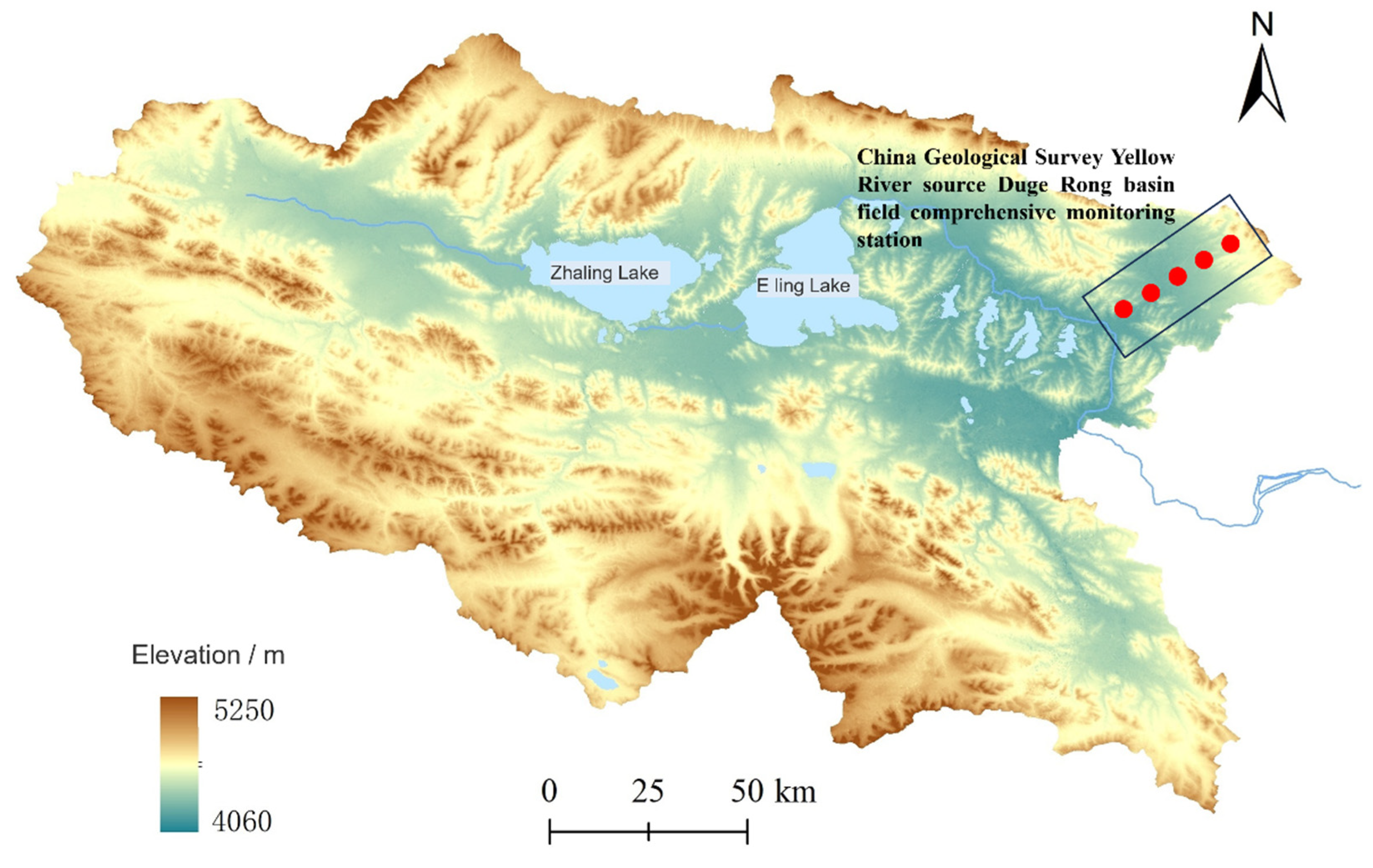
2.1. Overview of the Study Area

The Duogerong Basin in the source of the Yellow River is a small intermountain basin, roughly in the NW to southeast trend, about 40 km long and about 20 km wide; the average elevation of the basin is 4300 M A. S. L. Changshitou Mountain, a branch of the Buqing Mountains, is northeast of the basin. To the south, it is separated from the broad valley of the main channel of the Yellow River by some low hills, forming a relatively closed and independent basin. It only communicates with the main channel of the Yellow River through a relatively wide and flat valley in the southwest. National Highway 214 and the newly built Gongyu Expressway pass over the Changshek Mountain in parallel, dive into the basin, cross the basin in a southwest direction, and exit the basin from the edge of the valley at the outlet of the basin [26,27,28,29]. The base of the basin is flat and slopes slightly from the feldspar mountain in the northeast to the outlet in the southwest, decreasing by approximately 7 m per kilometer. Affected by the topography, the southwest part of the basin is rich in surface water, large and small lakes are scattered, and several meandering seasonal streams converge towards the outlet. The vicinity of Gongyu Expressway K430 is located in the central and southern part of Duogerong Basin, close to the exit of the basin, which is the place where the surface and groundwater of the basin gather. The loose sediments in this section mainly consist of three layers: the surface layer is about 1 m-thick Holocene loessial silty soil, the middle is about a few meters-thick late Pleistocene aeolian fine sand or silty sand, and below 7~8 m are river-lake fine sand-silty clay interbedded sediments. Sufficient moisture and light conditions provide a suitable environment for soil freeze–thaw cycle and water migration [20,30,31,32].

2.2. Data Acquisition

The data obtained in the study included meteorological data and soil temperature and humidity data. Meteorological data collection was mainly based on the small automatic weather station (TRM-ZS1) deployed in the Duogerong Basin of the Yellow River Source, which was used to observe meteorological elements such as temperature, precipitation, and atmospheric radiation in the sample site. The time resolution of observation was 60 min, and the observation time was from 10 September 2022 to 10 September 2023. To monitor the soil hydrothermal characteristics, a soil profile temperature, water content observation equipment with a depth of 300 cm, and a cable to record the permafrost ground temperature, with a depth of 2250 cm, were set up. The soil hydrothermal profile observation equipment consisted of 8 soil temperature and moisture content probes with an applicable range of −40~80 °C, resolving 0.1 °C with an accuracy of ±0.2 °C. The monitored water content was liquid water, excluding ice. The soil moisture content is the volume moisture content, and the unit is expressed in %. We set up 18 frozen soil temperature probes, the temperature range is −50 °C ± 100 °C, the accuracy is ±0.2 °C, the resolution is 0.1 °C, and the working environment is −40 °C~+65 °C. The DATA collector is a low-power terminal DATA-9201 equipped with a solar power generation system. The observation time resolution was 60 min. The soil moisture probe was located at 20, 40, 60, 100, 150, 200, 250, and 300 cm depths. The depths of the frozen soil temperature probe were 20, 80, 150, 250, 350, 450, 550, 650, 750, 850, 950, 1050, 1250, 1450, 1650, 1850, 2050, and 2250 cm.

2.3. Data Analysis Methods

Daily soil temperature and humidity and meteorological observation values were averaged and used as daily values of soil temperature and humidity and temperature. Due to the limitation of field observation conditions, the effect of salt on soil freeze–thaw was not considered in this study. A value of 0 °C indicates soil freezing, and vice versa, it indicates soil melting. Based on this, the starting and ending dates of each stage of the freeze–thaw cycle were judged, and the rules of soil water and heat change in each period were analyzed.

3. Results and Analysis

3.1. Variation in Water and Heat in Freeze–Thaw Cycle of Surface Soil

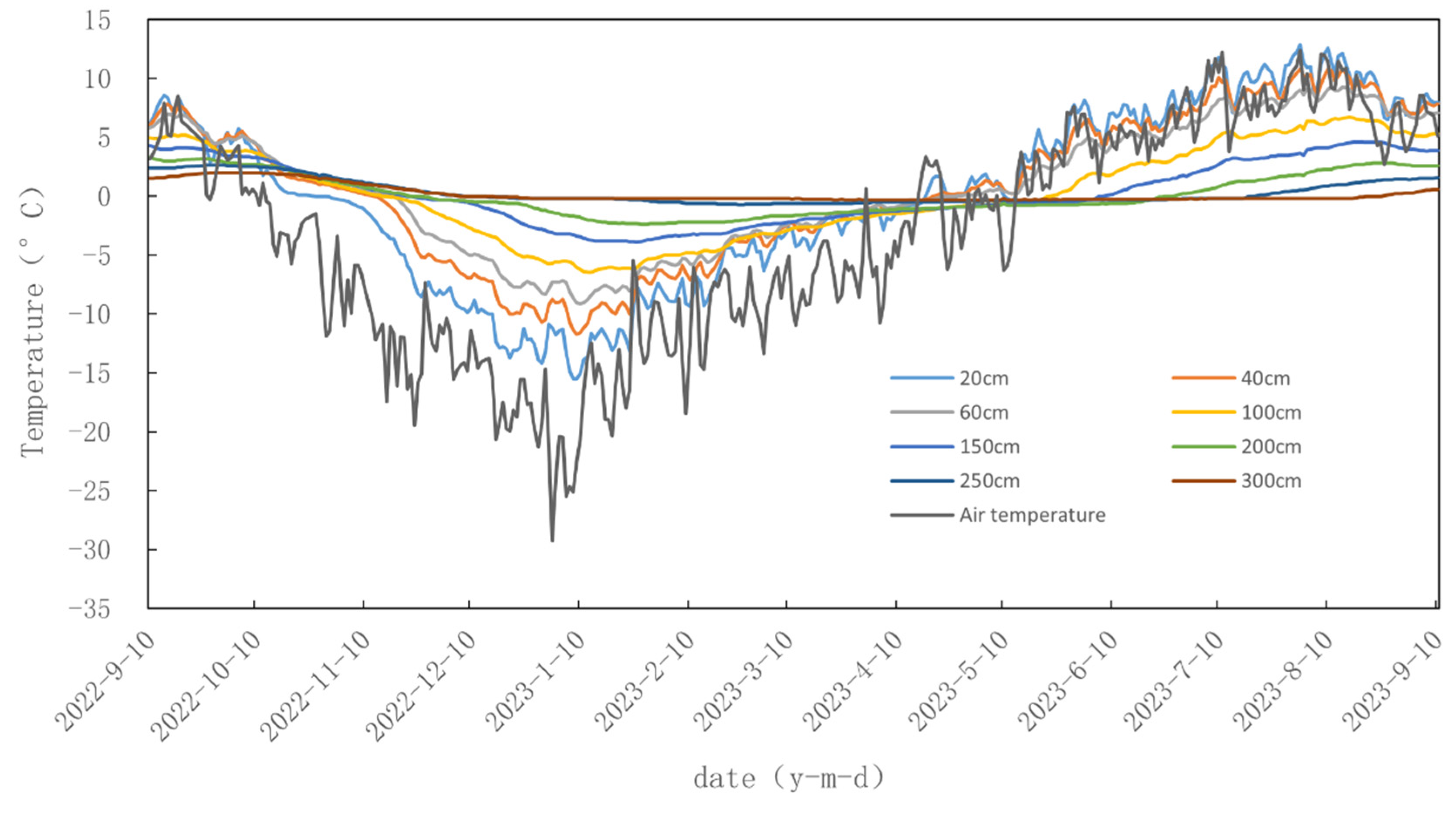
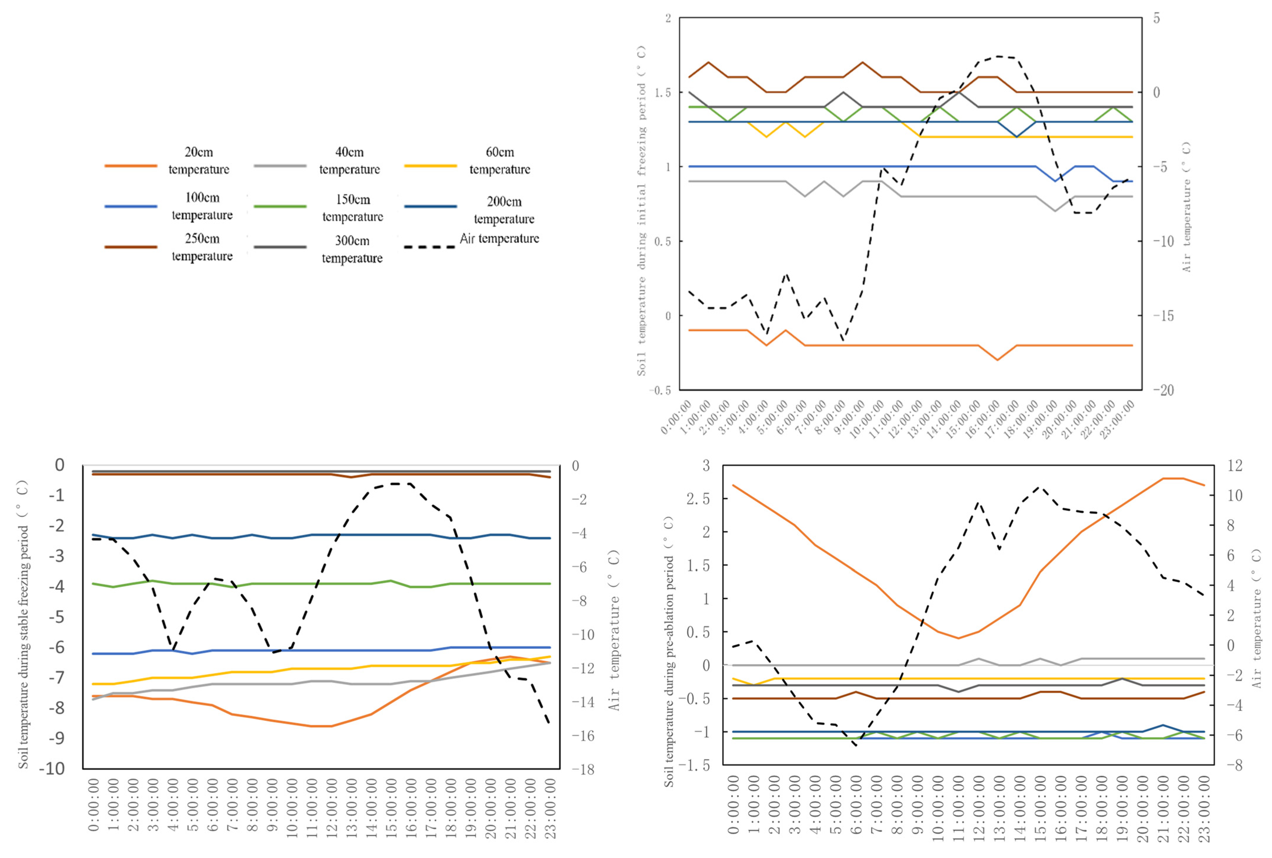
3.1.1. Changes in Air Temperature and Soil Temperature

During the observation period, the average temperature in the study area was −4.54 °C, the highest temperature was 19.7 °C (13 August 2023), and the lowest temperature was −40.7 °C (22 January 2016) (Figure 2). The temperature variation of surface soil (0–60 cm) was roughly the same as that of air temperature, showing quasi-periodic changes, and the variation amplitude of soil temperature decreased with the increase in soil depth. There was a time difference between the temperature change in the deep soil (below 60 cm) and the surface soil. The maximum temperature of the surface soil appeared on 2 August, while the maximum temperature of the deep soil appeared on 17 August. The minimum surface soil temperature occurred on 19 January, and the minimum deep soil temperature on 13 January (Figure 3). Under the influence of near-earth air temperature, the fluctuation in surface soil temperature was the same as that of air temperature. The fluctuation amplitude was inversely proportional to the soil depth. In contrast, the fluctuation in deep soil temperature was gentle. The noticeable fluctuation occurred predominantly in the annual maximum and minimum air temperature period, indicating that ground temperature was mainly affected by near-earth air temperature. The influence of air temperature on deep soil temperature is less than the surface soil’s. The soil temperature showed seasonal variation with depth, and soil temperature increased from late October to late April. The temperature increased from early May to mid-October, and the soil temperature decreased with an increasing depth (Figure 2). According to the analysis results of ground temperature data in winter, the freezing depth of soil in the coldest period of the year was about 2.5 m, and the soil temperature below floated around 0 °C until the underground temperature of 22.5 m was relatively stable. In other seasons, the depth of the zero temperature temperate zone is less than 2.5 m, and there is no geothermal layer below 0 °C, indicating that there is no permafrost in this region, and the maximum depth of seasonally frozen soil is 2.5 m (Figure 4 and Figure 5).

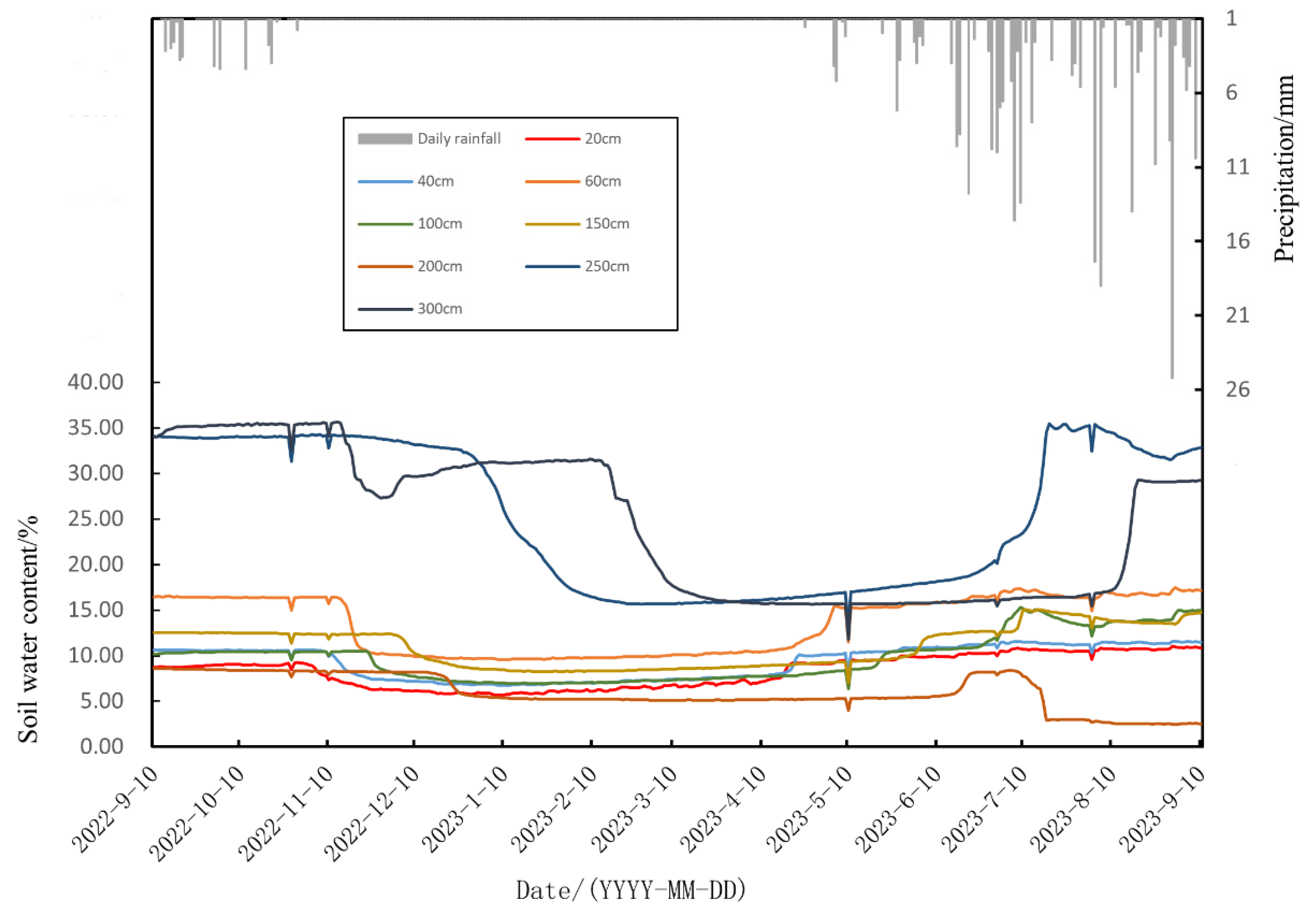
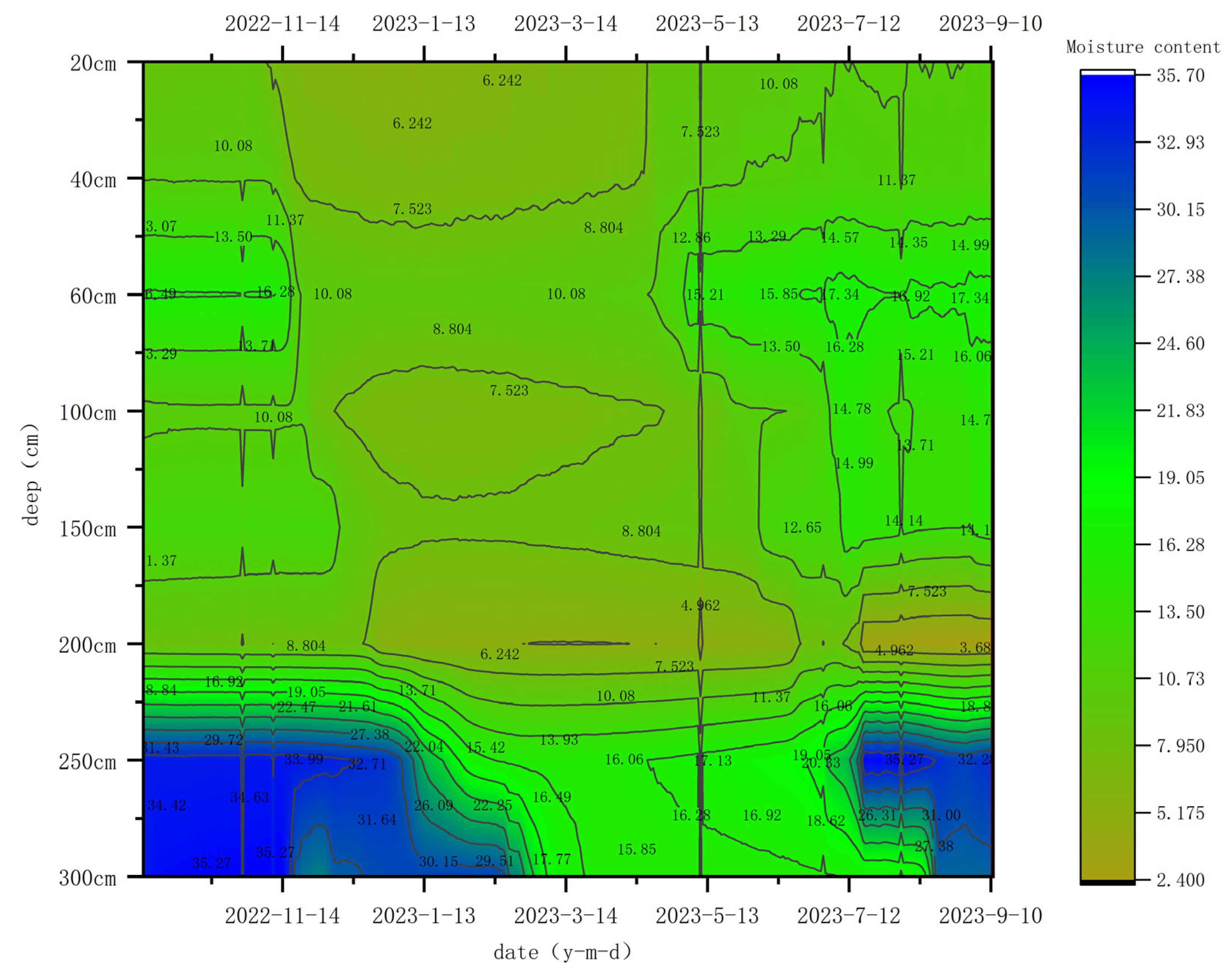
3.1.2. Seasonal Variation in Precipitation and Soil Moisture Content

The total precipitation during the observation period was 376 mm, and the maximum daily precipitation was 25.2 mm on 31 August 2023. The precipitation was most concentrated from May to October, and the soil moisture content changed sharply during that period. The soil moisture content changed with the precipitation season. The soil moisture content was relatively low in the range of 0–200 cm underground. Except that the moisture content of 60 cm and 150 cm was slightly higher, the soil moisture content of other layers was positively correlated with the depth (Figure 6). In the range of 200–300 cm, the increasing frequency of soil moisture content was pronounced with the deepening of the depth (Figure 7). The observation data show that the soil moisture content from the surface to the deep underground decreases when rainfall decreases from the wet to the dry period. During the observation period, after no rainfall on November 10, the turning point of soil water content within 200 cm was relatively close and appeared successively at −20, −40, −60, −100, −150–200, and −250 cm. It can be seen that after rainfall infiltration had a specific effect on soil water recharge, the soil water content was gradually reduced. The lag time is positively correlated with the subsurface soil depth. The soil water at 300 cm underground had two prominent decline stairs, the first on 16 November 2022, and the second on 6 February 2023. The time when the moisture content at −250 cm showed an obvious turning point occurred on 29 December 2022, while the time when the soil moisture content at −300 cm showed a second obvious turning point was later than that at −250 cm, which was in line with the law of gradually decreasing soil moisture content from surface layer to deep layer after the dry period as mentioned above. Compared to the soil temperature data of −0.2 degrees when the soil water content first turned over at −300 cm, it can be deduced that the layer began to freeze gradually (Figure 5), with a consequent decrease in the water content of the soil. The comparison of the near-earth temperature data before and after the transition shows that on 16 November 2022, the temperature dropped sharply (−17.43 °C), which is 6 °C lower than the previous day’s temperature.
From November to April of the following year, the precipitation was scarce, mainly snowfall, which was the main stage of the soil freeze–thaw phenomenon. Due to freezing, the soil moisture content within 300 cm underground decreased significantly (Figure 7), and the soil moisture content above 20 cm also fluctuated slightly during this period (Figure 6). Those fluctuations indicate that the soil layer is affected by external environmental factors during the freeze–thaw period. After early May, as the daily average temperature turned positive, the frozen soil began to melt and the soil moisture content increased. At this time, it was mainly affected by the melting of snow and rainfall. The turning point for the increase in moisture content also showed a turning change successively from the surface to the deep underground soil (Figure 6). The soil water content change lasted from mid-May to mid-August and reached a stable level.

3.2. Characteristics of Daily Freeze–Thaw Cycle of Soil

3.2.1. Division of Freeze–Thaw Stage

This study used the surface soil temperature within the range of 20 cm as the classification standard, regardless of salt’s effect on the soil’s freezing temperature. When the soil temperature was less than 0 °C, the soil was considered frozen; otherwise, the soil was considered melting. When the daily minimum temperature of the soil was less than 0 °C, it was considered that the soil began to enter the freezing period. When the daily maximum temperature of the soil was less than 0 °C, it was considered that the soil was completely frozen. When the daily minimum temperature of soil was higher than 0 °C, the soil was considered to be completely melted. When the maximum soil temperature in a day was higher than 0 °C, and the minimum temperature was less than 0 °C, the daily freeze–thaw cycle was considered to occur. According to this law, the freeze–thaw cycle was divided into an initial freezing period, stable freezing period, pre-ablation period, post-ablation period, and complete ablation period (Table 1). Deep soil below 300 cm remained unfrozen throughout the freeze–thaw cycle (Figure 4). Because the monitoring profile selected by the project team passed through the seasonal frozen soil area, permafrost area, and the frozen rock area of the Duogerong Basin, the observation point was just located in the seasonal frozen soil area; no deep permafrost was observed in the study. At the same time, combing through the drilling data in August 2022, the study assessed that August was the area’s highest temperature period. No frozen soil was found in the process of drilling core recording, which is consistent with the analysis results of this observation data, further verifying that this point is a seasonal frozen soil area.

3.2.2. Daily Variation Characteristics

The Qinghai–Tibet Plateau is characterized by a high altitude and intense solar radiation. During the freeze–thaw cycle, water and energy are exchanged between the surface soil and the atmosphere, resulting in the daily freeze–thaw cycle. In order to analyze the changes in soil water and heat in different stages of the freeze–thaw cycle, the daily changes in soil water and heat in five stages were selected for analysis (Figure 8 and Figure 9). After the arrival of winter, the near-surface soil first enters the initial freezing period. The temperature of the surface 20 cm soil fluctuates around 0 °C with the temperature. With the decrease in air temperature, the maximum daily surface soil temperature dropped below 0 °C, began to enter a stable freezing period, and the freezing depth gradually deepened. Due to the significant temperature difference between day and night, the surface soil was exposed to ultraviolet light after sunrise, and the soil temperature rose after sunset. Because the thermal conductivity of soil is lower than that of air, the peak arrival time of surface soil is slightly delayed than that of air near the ground. After entering the stable freezing period, the moisture content of the surface layer above 200 cm was significantly lower than that of the initial freezing period, and the gradient of moisture content was significantly reduced. At the same time, the moisture content of 250 cm and 300 cm soil also decreased, especially at 250 cm, which was directly affected by the freezing depth.
The temperature began rising slowly in mid-January when the freezing depth reached the maximum. When the temperature approached 0 °C in early April, the ground temperature fluctuated around −0.2 °C and began entering the pre-ablation stage. The daily variation temperature of the soil above the surface of 20 cm fluctuated in the range of 0–2.5 °C, while the temperature of the soil below 20 cm was still below 0 °C. Because the melting stage had just entered, the moisture content of the soil above the surface of 20 cm had little change compared with the stable freezing period. In the range of 200 cm, the gradient of soil water content increases, and the daily freeze–thaw cycle gradually begins. The temperature continued to rise and entered the ablation stage at the end of April, with the soil temperature floating around 0 °C. With the rise in air temperature, the evaporation of surface soil water above 20 cm increased, so the moisture content of soil above 20 cm decreased slightly, and the moisture content of lower soil increased. During that period, the soil water is still frozen and has not completely melted, the temperature difference in the soil was small, and it floated up and down at 0 °C. With the increased air temperature, the minimum ground temperature of 20 cm was higher than 0 °C and entered the complete ablation period. At that time, the minimum ground temperature of 20 cm at night was close to 10 °C, the temperature difference between day and night was less than 2 °C, and the ground temperature of each layer increased rapidly. Due to the intense ultraviolet irradiation, the daily change in soil moisture content in the range of 20 cm was not noticeable compared with the previous stage. However, the change in soil moisture content at 250 cm was more considerable.

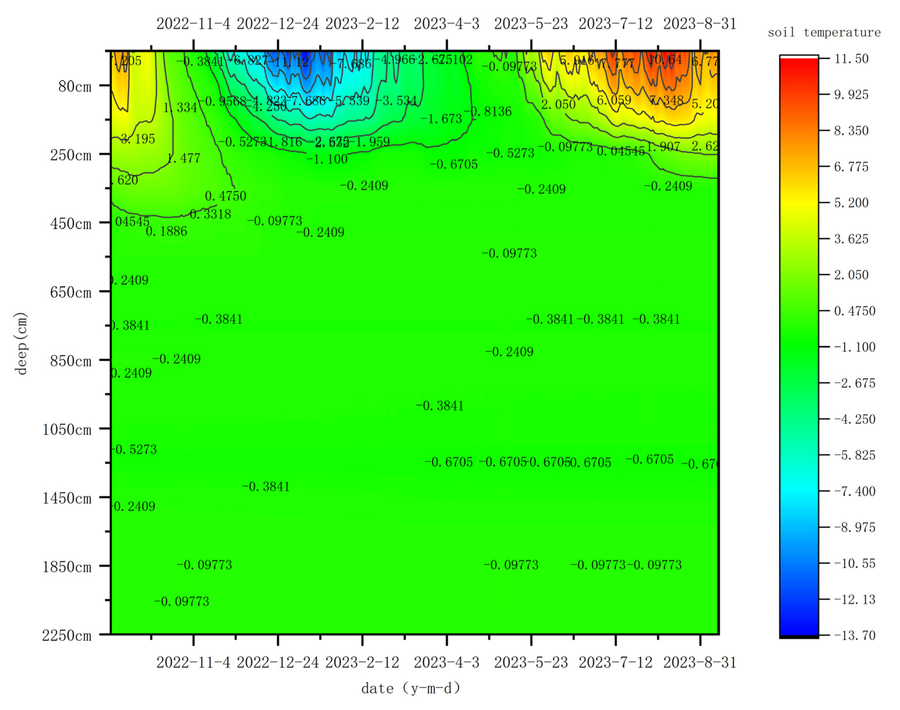
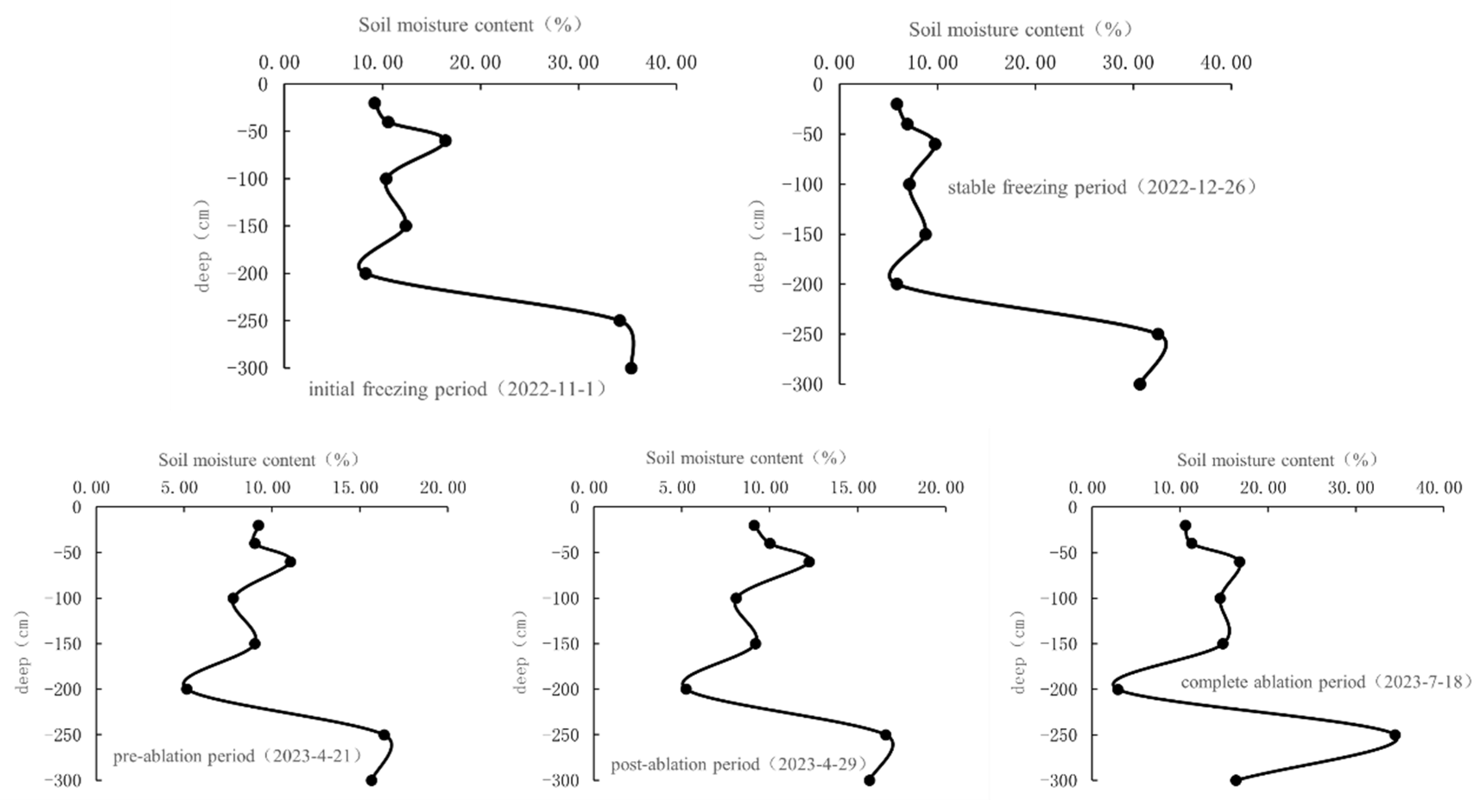
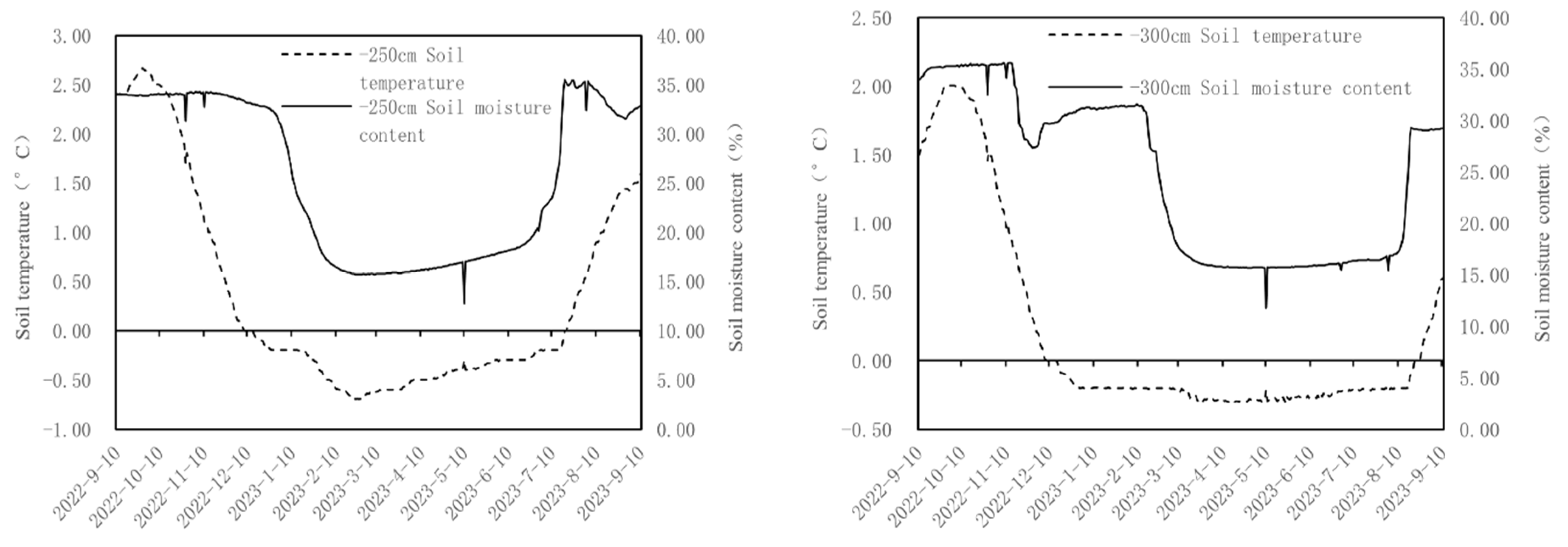
3.2.3. Variation Characteristics of Soil Profile Temperature and Humidity

To explore the hydrothermal characteristics of soil profiles at different stages, the profile distributions of daily mean water content and daily mean temperature of the soil at different underground depths were analyzed (Figure 10 and Figure 11). In the early freezing period, the soil temperature in the upper 60 cm range showed an increasing trend with the increase in depth, and the soil temperature in the underground 60–300 cm range showed a stable fluctuation trend in the 1–1.5 °C range. In the stable freezing period, the soil temperature increased with the increase in depth. In the early ablation stage, the ground temperature in the range above 100 cm decreased with the increase in depth, while in the range of 100–300 cm, there was a positive correlation. In Figure 10, we can see that with the arrival of the ablation period, the near-earth temperature had a specific influence on the upper soil temperature. At the same time, due to the rapid air warming and slow soil temperature change, the soil moisture content at each stage of freeze–thawing at 100 cm underground showed a consistent trend of variation with depth. At the later ablation stage, soil temperature showed a double-peak trend, first increasing, then decreasing, and then increasing with the depth increase. The first transition occurred at a depth of 40 cm underground. At this time, the soil temperature rose rapidly with the temperature increase since the late ablation period. However, the temperature difference between day and night was still significant in the general period, and the surface 20 cm soil experienced large diurnal fluctuations due to the influence of night temperature. The second turning point occurs at 200 cm, indicating that the surface radiation heat has been transferred to the deep soil at this time. When the soil enters the complete ablation period, the soil temperature presents a regular decreasing trend with the increase in depth. The soil completely melts at this time, and the temperature is mainly affected by the downward transmission of solar radiation.
The soil moisture content increased with the increase in depth in the range of 60 cm, fluctuated and decreased in the range of 60–200 cm, and increased significantly in the range of 200–300 cm (Figure 11). The peak water content of the five stages all appeared at a depth of 250 cm, indicating that a water accumulation area was formed at a depth of about 250 cm, and the water from precipitation and soil melting accumulated at a depth of 250 cm through infiltration. It is worth noting that due to the differences in soil texture and water permeability of each layer, a small peak appeared at 60 cm in each freeze–thaw stage. The soil water retention was better in this layer, and the soil water infiltration rate decreased slightly. According to the drilling records, there were sand and gravel layers within 30 m underground in this area. The figure shows that the dense sand layer with low porosity is more conducive to water storage. With global warming, the degradation of frozen soil on the Qinghai–Tibet Plateau and the increased water storage space in the active layer will lead to changes in base discharge, a problem worthy of attention.

3.3. Mechanism of Coupling Change in Water and Heat in Soil Freeze–Thaw Process

The variation characteristics of soil temperature and moisture content in each subsurface layer during an annual freeze–thaw cycle of seasonal permafrost in the study area are shown in Figure 12. The figure shows the variation trend of soil temperature and moisture in each layer is similar. Overall, the soil moisture in the melting state is more considerable. Due to the influence of precipitation, evaporation, plant transpiration, and other factors, soil water content changes sharply, and the fluctuation in soil water content decreases gradually with the increase in depth. When the soil is frozen, the soil moisture content decreases significantly, and the fluctuation range is smaller than that in the melting state. At the same time, the soil temperature change and the freeze–thaw process are affected by soil water content. When water is undergoing phase transition, it will release or absorb much heat. At the same time, because water’s heat capacity is higher than the soil’s, it will absorb more heat during the heating process, making the soil layer with high water content warm slowly and the temperature rise range is small. When the soil freezes, much heat is released, which makes the soil temperature gradient smaller, thus slowing down the downward migration of the freezing front. When the soil melts, it will absorb much heat, making the temperature gradient smaller and slowing down the melting front’s downward migration. Figure 12 shows that the change in the freezing and melting process of the soil is closely related to the soil water content. The water in the soil slows down the freezing and melting process simultaneously and considerably affects the heat distribution in the soil. Furthermore, Figure 12 shows that during the gradual freezing of soil in the freeze–thaw cycle stage, the soil temperature changes in each layer lag slightly relative to the changes in soil water, indicating the effects of soil water on soil temperature changes.
Different soil porosity, soil density, and soil water surface tension will affect the transfer efficiency of soil water and temperature. At the same time, soil water will migrate to the ground temperature surface when driven by the soil temperature gradient. When the freeze–thaw cycle affects the seasonal frozen soil, the temperature gradient will drive the movement of soil water to the freezing front layer during the freezing process. At this time, the phase transition of soil water at the freezing front also increases the amount of transported soil water driven by the temperature gradient. If the soil is frozen, soil water migrates through the unfrozen water film under the effect of temperature gradient. Hence, the unfrozen water film gradually becomes thinner as the soil temperature decreases, and the soil water migration decreases. It is evident that the temperature of the seasonal frozen soil layer significantly impacts soil water changes.
A correlation analysis was carried out between the daily mean values of soil temperature and soil water content in each layer, and the results are shown in Table 2. Except that the correlation between soil temperature and water content in 200 cm and 300 cm underground layers is slightly worse, the correlation between soil temperature and water content in other layers is above 0.9. It can be seen that the correlation between temperature and moisture content of soil 20 cm underground is 0.953, that between temperature and moisture content of soil 4 cm underground is 0.972, that between temperature and moisture content of soil 60 cm underground is 0.948, and that between temperature and moisture content of soil 100 underground is 0.94. The correlation between soil temperature and water content in subsurface 150 is 0.954, and the correlation between soil temperature and water content in the above layers is maintained at 0.95 or above, which indicates that the correlation is higher than that in other layers. The soil temperature and soil water content in other layers also maintained a high level, and both passed the 0.01 significance level test, indicating that soil water content was closely related to temperature change during the freeze–thaw cycle of soil. Due to the effect of soil thermal conductivity, the fluctuation range of soil temperature gradually decreases with the increase in depth, and the influence on soil water is also gradually weakened, which is consistent with the correlation between soil temperature and water content in each layer in the table decreasing with the increase in depth.

4. Conclusions

Through the analysis of the dynamic changes in soil water and heat in the seasonal frozen soil area of the Dugaili Basin at the source of the Yellow River, the following conclusions were obtained:
(1)
By analyzing and organizing the data from monitoring stations, this paper effectively provides the annual meteorological data of this region, which can be used as the authoritative meteorological data of this region. Through the analysis of soil temperature and moisture content, the characteristics of the freeze–thaw cycle of soil in the alpine meadow in the source region of the Yellow River were accurately grasped, which laid a good foundation for the subsequent comparative study of freeze–thaw characteristics of alpine meadow.
(2)
The soil and water content changes in each layer change periodically with the near-ground air temperature, and the degree of influence gradually weakens with the increase in depth. There is a certain lag in the transfer process of soil temperature.
(3)
In the seasonal frozen soil area of the alpine grassland in the Dugelong Basin at the source of the Yellow River, the maximum freezing depth is about 250 cm below the surface. The freezing time mainly lasts from early November to early May, including five stages: initial freezing period, stable freezing period, early ablation period, late ablation period, and complete ablation period.
(4)
The daily freeze–thaw cycle in the seasonal frozen soil of the alpine grassland in the Dugelong Basin at the source of the Yellow River mainly occurred on the soil surface during the initial freezing period, and the pre-melting period, solar radiation, and near-earth temperature were the main influencing factors.
(5)
The variation trend of the soil moisture content at different freezing and thawing stages in the alpine grassland of Dugelong Basin in the Yellow River source showed consistency with the depth. The soil moisture content increased with the depth increasing in the range of 60 cm, fluctuated and decreased in the range of 60–200 cm, and increased significantly in the range of 200–300 cm.
(6)
There is a significant correlation between soil temperature and water content in each subsurface layer in the seasonal frozen soil area of the alpine grassland in the Dugelong Basin, the source of the Yellow River, especially in the range of 40 cm near the surface. The change in soil temperature gradient has a specific effect on soil water distribution, and the soil temperature is negatively affected during the phase transition of soil water.

Author Contributions

Investigation, L.Z.; Data curation, L.C., F.X., B.Z. and X.C.; Writing—original draft, B.L.; Writing—review & editing, Y.Z.; Project administration, B.L. and J.L. All authors have read and agreed to the published version of the manuscript.

Funding

The Youth Fund of Hebei Province (D2021504003); this work was supported by the project of China Geological Survey (DD20230422).

Data Availability Statement

The data that support the findings of this study are available upon reasonable request from the authors.

Acknowledgments

I would like to thank all my colleagues for their help with this paper, especially researcher Liu Jingtao for giving me the opportunity to practice in this project. At the same time, I would like to thank Zhu Liang, Xie Fei, Chen Xi, and other colleagues for their strong support in the installation process, Zhang Yuxi, Chen Liang and other colleagues for their guidance and help in the analysis process of my paper, and other colleagues of the project team for their support and contributions to the project.

Conflicts of Interest

The authors declare no conflicts of interest.

References

  1. Lin, Z.; Zuo, Z.; Xiao, D.; You, Q. Soil moisture associated with freeze–thaw process modulated growing-season temperature rise in the Tibetan Plateau. Clim. Dyn. 2023, 61, 3619–3631. [Google Scholar] [CrossRef]
  2. Zhang, Z.; Wang, Y.; Ma, Z.; Lv, M. Response mechanism of soil structural heterogeneity in permafrost active layer to freeze–thaw action and vegetation degradation. Catena 2023, 230, 107250. [Google Scholar] [CrossRef]
  3. Shen, Q.; Liu, X.; Zhou, X.; Zhang, Z.; Chen, Q. Spatio-temporal variation patterns of diurnal freeze-thaw cycles of the near-surface soil on the Qinghai-Tibet Plateau between 2002 and 2020. Acta Geogr. Sin. 2023, 78, 587–603. [Google Scholar]
  4. Wang, Q.; Yang, Q.; Guo, H.; Xiao, X.; Jin, H.; Li, L.; Zhang, T.; Wu, Q. Hydrothermal variations in soils resulting from the freezing and thawing processes in the active layer of an alpine grassland in the Qilian Mountains, northeastern Tibetan Plateau. Theor. Appl. Climatol. 2019, 136, 929–941. [Google Scholar] [CrossRef]
  5. Wu, T.; Li, H.; Lyu, H. Effect of freeze–Thaw process on heat transfer and water migration between soil water and groundwater. J. Hydrol. 2023, 617, 128987. [Google Scholar] [CrossRef]
  6. Gao, Y.; Luo, D.; Chen, F.; Lei, W.; Jin, H. Characteristics of the thermal regime and freeze-thaw cycles on the ground surface in permafrost regions in the Headwater Area of the Yellow River. Acta Geogr. Sin. 2023, 78, 604–619. [Google Scholar]
  7. Wang, L.; Wu, Q.; Zhang, W.; Fu, Z.; Gao, S. Aeolian sand cover affects the soil hydrothermal state and permafrost degradation on the Qinghai-Tibet Plateau. Geoderma 2023, 435, 116515. [Google Scholar] [CrossRef]
  8. Xiao, X.; Wu, H.; Zhang, F.; Zhang, C.; Yu, Z.; Wang, G.; Qaiser, F.R. Subsurface mixing of different soil water pools in a permafrost-underlain headwater catchment, Qilian Mountains, Northeastern Tibetan Plateau. J. Hydrol. 2023, 628, 130478. [Google Scholar] [CrossRef]
  9. Li, T.; Tian, D.; He, Y.; Zhang, R.; Wang, J.; Wang, F.; Niu, S. Threshold response of ecosystem water use efficiency to soil water in an alpine meadow. Sci. Total Environ. 2023, 908, 168345. [Google Scholar] [CrossRef] [PubMed]
  10. Gao, Z.; Lin, Z.; Niu, F.; Luo, J. Soil water dynamics in the active layers under different land-cover types in the permafrost regions of the Qinghai–Tibet Plateau, China. Geoderma 2020, 364, 114176. [Google Scholar] [CrossRef]
  11. Wang, Q.; Jin, H.; Yuan, Z.; Yang, C. Synergetic variations of active layer soil water and salt in a permafrost-affected meadow in the headwater area of the Yellow River, northeastern Qinghai–Tibet plateau. Int. Soil Water Conserv. Res. 2022, 10, 284–292. [Google Scholar] [CrossRef]
  12. Jiao, Y.; Li, R.; Zhao, L.; Wu, T.; Xiao, Y.; Hu, G.; Qiao, Y. Processes of soil thawing-freezing and features of soil moisture migration in the permafrost active layer. J. Glaciol. Geocryol. 2014, 36, 237–247. [Google Scholar]
  13. Fu, Q.; Hou, R.; Li, T.; Wang, M.; Yan, J. The functions of soil water and heat transfer to the environment and associated response mechanisms under different snow cover conditions. Geoderma 2018, 325, 9–17. [Google Scholar] [CrossRef]
  14. Hu, G.; Zhao, L.; Wu, X.; Wu, T.; Li, R.; Xie, C.; Xiao, Y.; Pang, Q.; Liu, G.; Hao, J.; et al. A mathematical investigation of the air-ground temperature relationship in permafrost regions on the Tibetan Plateau. Geoderma 2017, 306, 244–251. [Google Scholar] [CrossRef]
  15. Liu, X.; Wang, Y.; Yang, W.; Lv, M.; Zhao, H. Effects of freezing–thawing cycle on the daily evapotranspiration of alpine meadow soil in Qinghai–Tibet Plateau. Environ. Earth Sci. 2020, 79, 533. [Google Scholar] [CrossRef]
  16. Yang, K.; Wang, C. Water storage effect of soil freeze-thaw process and its impacts on soil hydro-thermal regime variations. Agric. For. Meteorol. 2019, 265, 280–294. [Google Scholar] [CrossRef]
  17. Wang, G.; Hu, H.; Li, T. The influence of freeze–thaw cycles of active soil layer on surface runoff in a permafrost watershed. J. Hydrol. 2009, 375, 438–449. [Google Scholar] [CrossRef]
  18. Wei, C.; Yu, S.; Jichun, W.; Yaling, C.; Erxing, P.; Leonid, G. Soil hydrological process and migration mode influenced by the freeze-thaw process in the activity layer of permafrost regions in Qinghai-Tibet Plateau. Cold Reg. Sci. Technol. 2021, 184, 103236. [Google Scholar] [CrossRef]
  19. Cheng, H.; Wang, G.; Hu, H.; Wang, Y. The variation of soil temperature and water content of seasonal frozen soil with different vegetation coverage in the headwater region of the Yellow River, China. Environ. Geol. 2008, 54, 1755–1762. [Google Scholar] [CrossRef]
  20. Ran, H.; Fan, J.; Huang, J. Characteristics of water and heat change during the freezing-thawing process of soil profiles in the alpine cold steppe, Northern Tibetan Plateau. Pratacultural Sci. 2019, 36, 980–990. [Google Scholar]
  21. Cui, J.; Xin, Z.; Huang, Y. The spatiotemporal variations in freeze-thaw erosion in 2003–2020 on the Qinghai-Tibet Plateau. Acta Ecol. Sin. 2023, 43, 4515–4526. [Google Scholar]
  22. Tian, X.; Zhang, L.; Zhang, X.; Chen, Z.; Zhao, L.; Li, Q.; Gu, S. Evapotranspiration characteristics of degraded meadow and effects of freeze—Thaw changes in the Three-River Source Region. Acta Ecol. Sin. 2020, 40, 5649–5662. [Google Scholar]
  23. Li, Y.; Wen, J.; Liu, W.; Chen, Y.; Chen, Y.; Zhang, Q.; Liu, Z. The Spatio-temporal Distribution of the Start-end Date and Freezing Depth and their Relationships with Air Temperature over the Western China. Plateau Meteorol. 2023, 42, 657–670. [Google Scholar]
  24. Liang, B.; Li, X.; Zhang, D.; Shen, Y. Study on spatiotemporal changes of the freeze-thaw status of seasonally frozen ground and influencing factors in the Three Rivers Source Region from 1961 to 2019. J. Glaciol. Geocryol. 2023, 45, 382–394. [Google Scholar]
  25. Hu, G.J.; Zhao, L.; Li, R.; Wu, T.-H.; Pang, Q.-Q.; Wu, X.-D.; Shi, J. Characteristics of Hydro-thermal Transfer During Freezing and Thawing Period in Permafrost Regions. Soils 2014, 46, 355–360. [Google Scholar]
  26. Lan, A.; Lin, Z.; Fan, X.; Yao, M. Differences of Surface Energy and Shallow Soil Temperature and Humidity at Sunny and Shady Slopes in Permafrost Region, Beiluhe Basin, Qinghai-Tibet Plateau. Adv. Earth Sci. 2021, 36, 962–979. [Google Scholar]
  27. Ma, J.; Li, R.; Liu, H.; Wu, T.; Xiao, Y.; Du, Y.; Yang, S.; Shi, J.; Qian, Y. A review on the development of study on hydrothermal characteristics of active layer in permafrost areas in Qinghai-Tibet Plateau. J. Glaciol. Geocryol. 2020, 42, 195–204. [Google Scholar]
  28. Wei, W.; Liu, Y.; Ma, H.; Li, J. Freeze-Thaw Action Characteristics of Shallow Soil on Degraded Alpine Meadow in the Source Region of Three Rivers. J. Ecol. Rural. Environ. 2019, 35, 352–359. [Google Scholar]
  29. Zhang, G.; Lai, X.; Liu, K. Characteristics of Surface Water and Heat Exchange during Soil Freezing And Thawing of Maqu Station in the Source Area of the Yellow River. Plateau Meteorol. 2023, 42, 575–589. [Google Scholar]
  30. Chen, S.; Mao, X.; Shang, S. Response and contribution of shallow groundwater to soil water/salt budget and crop growth in layered soils. Agric. Water Manag. 2022, 266, 107574. [Google Scholar] [CrossRef]
  31. Meng, F.; Hou, R.; Li, T.; Fu, Q. Variability of Soil Water Heat and Energy Transfer Under Different Cover Conditions in a Seasonally Frozen Soil Area. Sustainability 2020, 12, 1782. [Google Scholar] [CrossRef]
  32. Wu, Y.; Wen, J.; Wang, Z.; Jia, D.; Liu, W.; Jiang, Y.; Lu, X. The Characteristics of Land-Atmospheric Water and Heat Exchange during Soil Freezing-Thawing Process over the Underlying Surface of the Alpine Grassland in the Source Region of the Yellow River. Plateau Meteorol. 2022, 41, 132–142. [Google Scholar]
Figure 1. Schematic diagram of the location of monitoring points in the Dugaili Basin in the source of the Yellow River.
Sustainability 16 01541 g001
Figure 2. Air temperature–earth temperature variation map.
Sustainability 16 01541 g002
Figure 3. Maximum and minimum ground temperature values of each layer.
Sustainability 16 01541 g003
Figure 4. Map of subsurface temperature variation of 300 cm.
Sustainability 16 01541 g004
Figure 5. Subsurface temperature variation map of 22.5 m.
Sustainability 16 01541 g005
Figure 6. Variation map of soil water content in each layer.
Sustainability 16 01541 g006
Figure 7. Soil moisture content contour map.
Sustainability 16 01541 g007
Figure 8. Soil freeze–thaw cycle temperature variation map.
Sustainability 16 01541 g008aSustainability 16 01541 g008b
Figure 9. Soil freeze–thaw cycle water content change map.
Sustainability 16 01541 g009
Figure 10. Temperature variation map of soil profile.
Sustainability 16 01541 g010
Figure 11. Water content change map of soil profile.
Sustainability 16 01541 g011
Figure 12. Soil temperature and moisture content change map of each layer.
Sustainability 16 01541 g012aSustainability 16 01541 g012b
Table 1. Freeze–thaw cycles over time.
Freeze–Thaw StageDate (y-m-d)Duration of DaysTrait
InitiationFinish
initial freezing period31 October 20223 November 20224 dMaximum surface soil temperature >0 °C, Minimum temperature <0 °C
stable freezing period4 November 20228 April 2023166 dMaximum daily surface soil temperature <0 °C
pre-ablation period9 April 202326 April 20238 dMaximum daily surface soil temperature >0 °C, Mean soil temperature <0 °C
post-ablation period27 April 202330 April 20234 dDaily minimum surface soil temperature <0 °C, Mean soil temperature >0 °C
complete ablation period1 May 202310 September 2023177 dMinimum surface soil temperature >0 °C
11 September 202230 October 2023
Table 2. Correlation analysis between soil temperature and moisture content in each layer.
Depth/cm204060100150200250300
Correlation coefficient0.9530.9720.9480.940.9540.2790.9090.885
Note: All of them passed the significance level test of 0.01.
Disclaimer/Publisher’s Note: The statements, opinions and data contained in all publications are solely those of the individual author(s) and contributor(s) and not of MDPI and/or the editor(s). MDPI and/or the editor(s) disclaim responsibility for any injury to people or property resulting from any ideas, methods, instructions or products referred to in the content.

