
A New Climatology of Vegetation and Land Cover Information for South America

 ,
,  ,
,
Abstract
1. Introduction
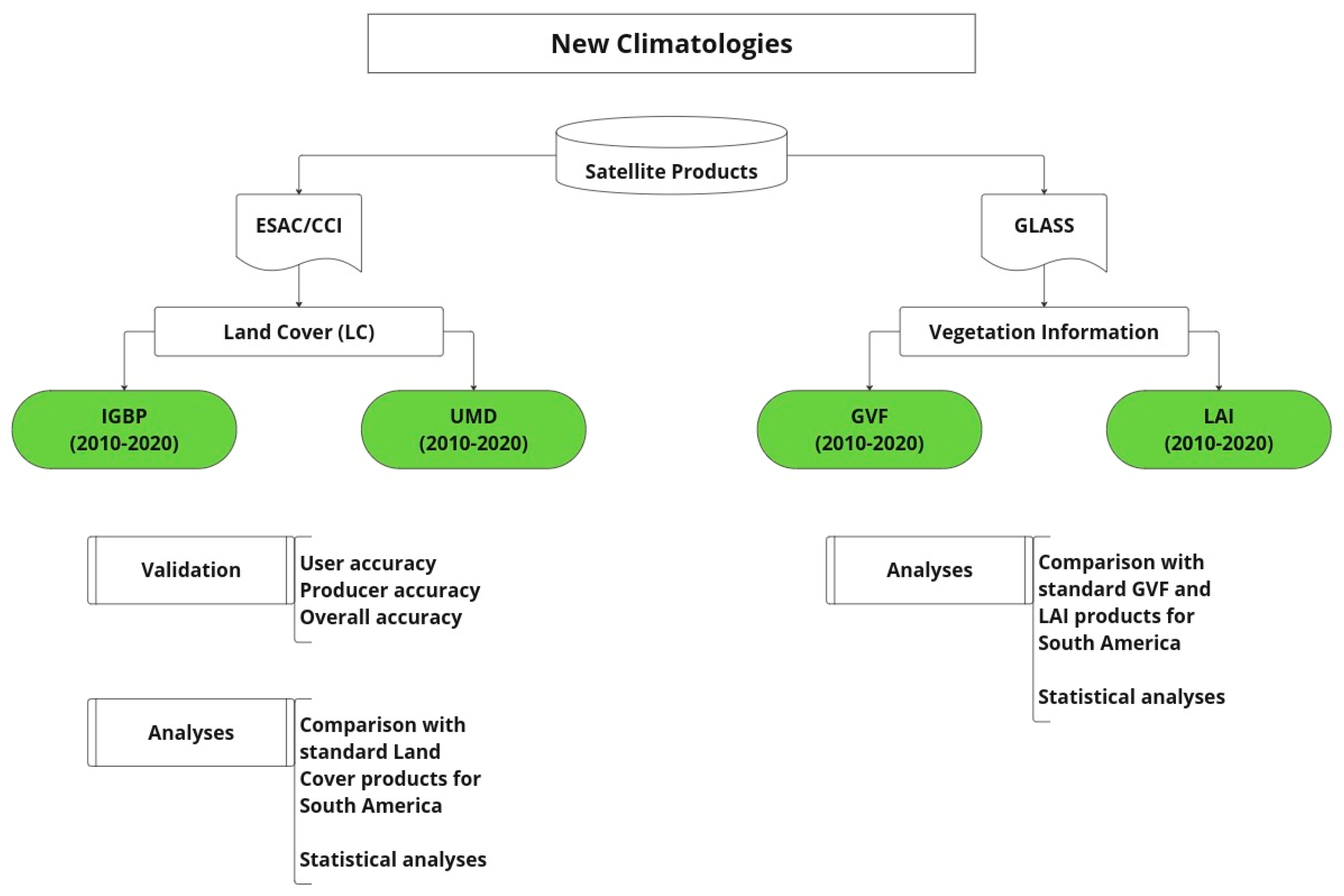
2. Materials and Methods
2.1. Land Cover Products
2.2. Vegetation Products
- (1)
- Forest (for IGBP and UMD, representing the Evergreen Needleleaf Forest class);
- (2)
- Savanna (for IGBP, this class represents Savanna, while for UMD, it is Wooded Grassland/Shrublands);
- (3)
- Agriculture (for IGBP and UMD, representing the Cropland class);
- (4)
- Grass (for IGBP and UMD, representing the Grassland class).
3. Results and Discussion
3.1. New Land Cover Climatology
3.2. Land Cover Assessment over SA
3.3. New Vegetation Climatology
4. Conclusions
Author Contributions
Funding
Institutional Review Board Statement
Informed Consent Statement
Data Availability Statement
Acknowledgments
Conflicts of Interest
References
- Poulter, B.; MacBean, N.; Hartley, A.; Khlystova, I.; Arino, O.; Betts, R.; Bontemps, S.; Boettcher, M.; Brockmann, C.; Defourny, P.; et al. Plant Functional Type Classification for Earth System Models: Results from the European Space Agency’s Land Cover Climate Change Initiative. Geosci. Model Dev. 2015, 8, 2315–2328. [Google Scholar] [CrossRef]
- Salazar, A.; Baldi, G.; Hirota, M.; Syktus, J.; McAlpine, C. Land Use and Land Cover Change Impacts on the Regional Climate of Non-Amazonian South America: A Review. Glob. Planet. Chang. 2015, 128, 103–119. [Google Scholar] [CrossRef]
- Silva, M.E.S.; Pereira, G.; da Rocha, R.P. Local and Remote Climatic Impacts Due to Land Use Degradation in the Amazon “Arc of Deforestation”. Theor. Appl. Climatol. 2016, 125, 609–623. [Google Scholar] [CrossRef]
- Oliveira, L.N.; de Aquino, C.M.S. Dinâmica temporal do uso e cobertura da terra na fronteira agrícola do matopiba: Análise na sub-bacia hidrográfica do rio Gurguéia-Piauí. Rev. Equador 2020, 9, 317–333. [Google Scholar] [CrossRef]
- Schneider, M.; Biedzicki de Marques, A.A.; Peres, C.A. Brazil’s Next Deforestation Frontiers. Trop. Conserv. Sci. 2021, 14, 19400829211020472. [Google Scholar] [CrossRef]
- Brando, P.; Macedo, M.; Silvério, D.; Rattis, L.; Paolucci, L.; Alencar, A.; Coe, M.; Amorim, C. Amazon Wildfires: Scenes from a Foreseeable Disaster. Flora 2020, 268, 151609. [Google Scholar] [CrossRef]
- Song, X.-P.; Hansen, M.C.; Potapov, P.; Adusei, B.; Pickering, J.; Adami, M.; Lima, A.; Zalles, V.; Stehman, S.V.; Di Bella, C.M.; et al. Massive Soybean Expansion in South America since 2000 and Implications for Conservation. Nat. Sustain. 2021, 4, 784–792. [Google Scholar] [CrossRef]
- Zalles, V.; Hansen, M.C.; Potapov, P.V.; Parker, D.; Stehman, S.V.; Pickens, A.H.; Parente, L.L.; Ferreira, L.G.; Song, X.-P.; Hernandez-Serna, A.; et al. Rapid Expansion of Human Impact on Natural Land in South America since 1985. Sci. Adv. 2021, 7, eabg1620. [Google Scholar] [CrossRef]
- Rodell, M.; Houser, P.R.; Jambor, U.; Gottschalck, J.; Mitchell, K.; Meng, C.-J.; Arsenault, K.; Cosgrove, B.; Radakovich, J.; Bosilovich, M.; et al. The Global Land Data Assimilation System. Bull. Am. Meteorol. Soc. 2004, 85, 381–394. [Google Scholar] [CrossRef]
- De Goncalves, L.G.G.; Shuttleworth, W.J.; Burke, E.J.; Houser, P.; Toll, D.L.; Rodell, M.; Arsenault, K. Toward a South America Land Data Assimilation System: Aspects of Land Surface Model Spin-up Using the Simplified Simple Biosphere. J. Geophys. Res. Atmos. 2006, 111, D17110. [Google Scholar] [CrossRef]
- de Ávila, Á.V.A.; de Gonçalves, L.G.G.; Souza, V.d.A.; Alves, L.E.R.; Galetti, G.D.; Maske, B.M.; Getirana, A.; Ruhoff, A.; Biudes, M.S.; Machado, N.G.; et al. Assessing the Performance of the South American Land Data Assimilation System Version 2 (SALDAS-2) Energy Balance across Diverse Biomes. Atmosphere 2023, 14, 959. [Google Scholar] [CrossRef]
- Zhen, Z.; Chen, S.; Yin, T.; Chavanon, E.; Lauret, N.; Guilleux, J.; Henke, M.; Qin, W.; Cao, L.; Li, J.; et al. Using the negative soil adjustment factor of soil adjusted vegetation index (SAVI) to resist saturation effects and estimate leaf area index (lai) in dense vegetation areas. Sensors 2021, 21, 2115. [Google Scholar] [CrossRef]
- Filipponi, F.; Valentini, E.; Xuan, A.N.; Guerra, C.A.; Wolf, F.; Andrzejak, M.; Taramelli, A. Global MODIS Fraction of Green Vegetation Cover for Monitoring Abrupt and Gradual Vegetation Changes. Remote Sens. 2018, 10, 653. [Google Scholar] [CrossRef]
- Pilotto, I.L.; Rodríguez, D.A.; Chan Chou, S.; Tomasella, J.; Sampaio, G.; Gomes, J.L. Effects of the Surface Heterogeneities on the Local Climate of a Fragmented Landscape in Amazonia Using a Tile Approach in the Eta/Noah-MP Model. Q. J. R. Meteorol. Soc. 2017, 143, 1565–1580. [Google Scholar] [CrossRef]
- Toure, A.M.; Reichle, R.H.; Forman, B.A.; Getirana, A.; De Lannoy, G.J.M. Assimilation of MODIS Snow Cover Fraction Observations into the NASA Catchment Land Surface Model. Remote Sens. 2018, 10, 316. [Google Scholar] [CrossRef]
- Fernandez, J.P.R.; Figueroa, S.N.; Éder, P.V.; Herdies, D.L.; Gonçalves, L.G.G.; Aravéquia, J.A. Relatório de Avaliação do Modelo CPT-WRF v1.2; Instituto Nacional de Pesquisas Espaciais: Cachoeira Paulista, Brazil, 2021; pp. 1–30. [Google Scholar]
- Bonan, G.B.; Levis, S.; Kergoat, L.; Oleson, K.W. Landscapes as Patches of Plant Functional Types: An Integrating Concept for Climate and Ecosystem Models. Glob. Biogeochem. Cycles 2002, 16, 5-1–5-23. [Google Scholar] [CrossRef]
- Kumar, S.V.; Peters-Lidard, C.D.; Tian, Y.; Houser, P.R.; Geiger, J.; Olden, S.; Lighty, L.; Eastman, J.L.; Doty, B.; Dirmeyer, P.; et al. Land Information System: An Interoperable Framework for High Resolution Land Surface Modeling. Environ. Model. Softw. 2006, 21, 1402–1415. [Google Scholar] [CrossRef]
- Chen, L.; Ma, Z.; Zhao, T. Modeling and Analysis of the Potential Impacts on Regional Climate Due to Vegetation Degradation over Arid and Semi-Arid Regions of China. Clim. Chang. 2017, 144, 461–473. [Google Scholar] [CrossRef]
- Lee, S.-J.; Berbery, E.H. Land Cover Change Effects on the Climate of the La Plata Basin. J. Hydrometeorol. 2012, 13, 84–102. [Google Scholar] [CrossRef]
- Fang, L.; Zhan, X.; Hain, C.R.; Liu, J. Impact of Using Near Real-Time Green Vegetation Fraction in Noah Land Surface Model of NOAA NCEP on Numerical Weather Predictions. Adv. Meteorol. 2018, 2018, 9256396. [Google Scholar] [CrossRef]
- Kumar, S.V.; Mocko, D.M.; Wang, S.; Peters-Lidard, C.D.; Borak, J. Assimilation of Remotely Sensed Leaf Area Index into the Noah-MP Land Surface Model: Impacts on Water and Carbon Fluxes and States over the Continental United States. J. Hydrometeorol. 2019, 20, 1359–1377. [Google Scholar] [CrossRef]
- Maertens, M.; De Lannoy, G.J.M.; Apers, S.; Kumar, S.V.; Mahanama, S.P.P. Land Surface Modeling over the Dry Chaco: The Impact of Model Structures, and Soil, Vegetation and Land Cover Parameters. Hydrol. Earth Syst. Sci. 2021, 25, 4099–4125. [Google Scholar] [CrossRef]
- Wang, X.; Zhang, Z.; Zhang, B.; Tian, L.; Arnault, J.; Kunstmann, H.; He, C. Quantifying the Impact of Land Use and Land Cover Change on Moisture Recycling with Convectio-Permitting WRF-Tagging Modeling in the Agro-Pastoral Ecotone of Northern China. J. Geophys. Res. Atmos. 2023, 128, e2022JD038421. [Google Scholar] [CrossRef]
- Guo, Z.; Ferrer, j.v.; Hürlimann, M.; Medina, V.; Puig-Polo, C.; Yin, K.; Huang, D. Shallow landslide susceptibility assessment under future climate and land cover changes: A case study from southwest China. Geosci. Front. 2023, 14, 101542. [Google Scholar] [CrossRef]
- Zhang, Q.; Sun, Q.; Dai, G.; Mu, M. Impact of Uncertainties in Land Surface Processes on Subseasonal Predictability of Heat Waves Onset Over the Yangtze River Valley. J. Geophys. Res. Atmos. 2024, 129, e2023JD038674. [Google Scholar] [CrossRef]
- Barati, A.A.; Zhoolideh, M.; Azadi, H.; Lee, J.; Scheffran, J. Interactions of Land-Use Cover and Climate Change at Global Level: How to Mitigate the Environmental Risks and Warming Effects. Ecol. Indic. 2023, 146, 109829. [Google Scholar] [CrossRef]
- Giri, C.; Long, J. Land Cover Characterization and Mapping of South America for the Year 2010 Using Landsat 30 m Satellite Data. Remote Sens. 2014, 6, 9494–9510. [Google Scholar] [CrossRef]
- Xiao, Z.; Liang, S.; Wang, J.; Chen, P.; Yin, X.; Zhang, L.; Song, J. Use of General Regression Neural Networks for Generating the GLASS Leaf Area Index Product from Time-Series MODIS Surface Reflectance. IEEE Trans. Geosci. Remote Sens. 2014, 52, 209–223. [Google Scholar] [CrossRef]
- Jia, K.; Liang, S.; Wei, X.; Yao, Y.; Yang, L.; Zhang, X.; Liu, D. Validation of Global LAnd Surface Satellite (GLASS) Fractional Vegetation Cover Product from MODIS Data in an Agricultural Region. Remote Sens. Lett. 2018, 9, 847–856. [Google Scholar] [CrossRef]
- Xu, B.; Li, J.; Park, T.; Liu, Q.; Zeng, Y.; Yin, G.; Zhao, J.; Fan, W.; Yang, L.; Knyazikhin, Y.; et al. An Integrated Method for Validating Long-Term Leaf Area Index Products Using Global Networks of Site-Based Measurements. Remote Sens. Environ. 2018, 209, 134–151. [Google Scholar] [CrossRef]
- Copernicus Climate Change Service, Climate Data Store. Land Cover Classification Gridded Maps from 1992 to Present Derived from Satellite Observations. Copernicus Climate Change Service (C3S) Climate Data Store (CDS). [CrossRef]
- Buchhorn, M.; Lesiv, M.; Tsendbazar, N.-E.; Herold, M.; Bertels, L.; Smets, B. Copernicus Global Land Cover Layers—Collection 2. Remote Sens. 2020, 12, 1044. [Google Scholar] [CrossRef]
- Broxton, P.D.; Zeng, X.; Sulla-Menashe, D.; Troch, P.A. A Global Land Cover Climatology Using MODIS Data. J. Appl. Meteorol. Climatol. 2014, 53, 1593–1605. [Google Scholar] [CrossRef]
- Hansen, M.C.; Defries, R.S.; Townshend, J.R.G.; Sohlberg, R. Global Land Cover Classification at 1 Km Spatial Resolution Using a Classification Tree Approach. Int. J. Remote Sens. 2000, 21, 1331–1364. [Google Scholar] [CrossRef]
- Llano, X.C. AcATaMa—QGIS Python Plugins Repository. Available online: https://plugins.qgis.org/plugins/AcATaMa/ (accessed on 30 December 2023).
- Novo, E.M.L.d.M. Sensoriamento Remoto: Princípios e Aplicações, 4th ed.; Blucher: São Paulo, Brazil, 2010; ISBN 978-85-212-0540-1. [Google Scholar]
- Olofsson, P.; Foody, G.M.; Stehman, S.V.; Woodcock, C.E. Making Better Use of Accuracy Data in Land Change Studies: Estimating Accuracy and Area and Quantifying Uncertainty Using Stratified Estimation. Remote Sens. Environ. 2013, 129, 122–131. [Google Scholar] [CrossRef]
- Olofsson, P.; Foody, G.M.; Herold, M.; Stehman, S.V.; Woodcock, C.E.; Wulder, M.A. Good Practices for Estimating Area and Assessing Accuracy of Land Change. Remote Sens. Environ. 2014, 148, 42–57. [Google Scholar] [CrossRef]
- Xiao, Z.; Liang, S.; Wang, J.; Xiang, Y.; Zhao, X.; Song, J. Long-Time-Series Global Land Surface Satellite Leaf Area Index Product Derived from MODIS and AVHRR Surface Reflectance. IEEE Trans. Geosci. Remote Sens. 2016, 54, 5301–5318. [Google Scholar] [CrossRef]
- Jia, K.; Yang, L.; Liang, S.; Xiao, Z.; Zhao, X.; Yao, Y.; Zhang, X.; Jiang, B.; Liu, D. Long-Term Global Land Surface Satellite (GLASS) Fractional Vegetation Cover Product Derived from MODIS and AVHRR Data. IEEE J. Sel. Top. Appl. Earth Obs. Remote Sens. 2019, 12, 508–518. [Google Scholar] [CrossRef]
- Kaufmann, R.K.; Zhou, L.; Knyazikhin, Y.; Shabanov, V.; Myneni, R.B.; Tucker, C.J. Effect of Orbital Drift and Sensor Changes on the Time Series of AVHRR Vegetation Index Data. IEEE Trans. Geosci. Remote Sens. 2000, 38, 2584–2597. [Google Scholar] [CrossRef]
- Gutman, G.; Ignatov, A. The Derivation of the Green Vegetation Fraction from NOAA/AVHRR Data for Use in Numerical Weather Prediction Models. Int. J. Remote Sens. 1998, 19, 1533–1543. [Google Scholar] [CrossRef]
- Camargo, A.P.; Sentelhas, P.C. Avaliação do desempenho de diferentes métodos de estimativa da evapotranspiração potencial no estado de São Paulo, Brasil. Rev. Bras. Agrometeorol. 1997, 5, 89–97. [Google Scholar]
- Pereira, D.d.R.; Yanagi, S.d.N.M.; de Mello, C.R.; da Silva, A.M.; da Silva, L.A. Desempenho de métodos de estimativa da evapotranspiração de referência para a região da Serra da Mantiqueira, MG. Ciênc. Rural 2009, 39, 2488–2493. [Google Scholar] [CrossRef]
- Moreira, T.d.J.R.V.; dos Santos, M.R.; Moreira, A.L. Estatística Básica, 1st ed.; EdUESPI: Teresina, PI, Brazil, 2021. [Google Scholar]
- Rozante, J.R.; Gutierrez, E.R.; Fernandes, A.D.A.; Vila, D.A. Performance of Precipitation Products Obtained from Combinations of Satellite and Surface Observations. Int. J. Remote Sens. 2020, 41, 7585–7604. [Google Scholar] [CrossRef]
- Righi, C.A.; Risante, A.P.O.; Packer, A.P.; Couto, H.T.Z. Biodiversity and biomass relationships in a Cerrado Stricto sensu in Southeastern Brazil. Environ. Monit. Assess. 2023, 195, 492. [Google Scholar] [CrossRef]
- Dos Santos, F.S.; Gomes, H.B.; de Barros, G.V.P.; Alves, L.E.R.; da Silva, D.F.; Costa, R.L.; Silva, F.D.d.S.; de Oliveira, J.F. Análise Sazonal dos Parâmetros Biofísicos Utilizando o Sensor MODIS para o Estado de Alagoas. Rev. Bras. Meteorol. 2021, 35, 955–968. [Google Scholar] [CrossRef]
- Zimbres, B.; Rodríguez-Veiga, P.; Shimbo, J.Z.; Bispo, P.C.; Balzter, H.; Bustamante, M.; Roitman, I.; Haidar, R.; Miranda, S.; Gomes, L.; et al. Mapping the stock and spatial distribution of aboveground woody biomass in the native vegetation of the Brazilian Cerrado biome. For. Ecol. Manag. 2021, 499, 119615. [Google Scholar] [CrossRef]
- Goltz, E.; Brandão, D.; Tomás, L.; Mantelli, L.R.; Adami, M.; Shimabukuro, Y.E.; Formaggio, A.R. Utilização de índices espectrais de vegetação do sensor MODIS na determinação de áreas suscetíveis a alagamento no pantanal sulmatogrossense/Use of MODIS Spectral Vegetation Indices to Determine Susceptible Flooding Area in the Pantanal Sulmatogrossense. Rev. Bras. Cartogr. 2007, 59, 35–44. [Google Scholar]
- Vourlitis, G.L.; Pinto, O.B.; Dalmagro, H.J.; de Arruda, P.E.Z.; de Almeida Lobo, F.; de Souza Nogueira, J. Tree Growth Responses to Climate Variation in Upland and Seasonally Flooded Forests and Woodlands of the Cerrado-Pantanal Transition of Brazil. For. Ecol. Manag. 2022, 505, 119917. [Google Scholar] [CrossRef]
- Noojipady, P.; Morton, C.D.; Macedo, N.M.; Victoria, C.D.; Huang, C.; Gibbs, K.H.; Bolfe, L.E. Forest Carbon Emissions from Cropland Expansion in the Brazilian Cerrado Biome. Environ. Res. Lett. 2017, 12, 025004. [Google Scholar] [CrossRef]
- De Espindola, G.M.; Figueredo, E.d.S.; Júnior, P.P.; Filho, A.A.d.R. Cropland Expansion as a Driver of Land-Use Change: The Case of Cerrado-Caatinga Transition Zone in Brazil. Environ. Dev. Sustain. 2021, 23, 17146–17160. [Google Scholar] [CrossRef]
- Stanimirova, R.; Graesser, J.; Olofsson, P.; Friedl, M.A. Widespread Changes in 21st Century Vegetation Cover in Argentina, Paraguay, and Uruguay. Remote Sens. Environ. 2022, 282, 113277. [Google Scholar] [CrossRef]
- Piquer-Rodríguez, M.; Butsic, V.; Gärtner, P.; Macchi, L.; Baumann, M.; Gavier Pizarro, G.; Volante, J.N.; Gasparri, I.N.; Kuemmerle, T. Drivers of Agricultural Land-Use Change in the Argentine Pampas and Chaco Regions. Appl. Geogr. 2018, 91, 111–122. [Google Scholar] [CrossRef]
- Alves, L.E.R.; Gomes, H.B.; dos Santos, F.S.; Correia Filho, W.L.F.; de Oliveira Júnior, J.F. Parâmetros Biofísicos Aplicados no Parque Nacional da Serra das Confusões, Piauí-Brasil. Rev. Bras. Meteorol. 2020, 35, 597–604. [Google Scholar] [CrossRef]
- Silva, B.K.N.; Amorim, A.C.B.; Silva, C.M.S.; Lucio, P.S.; Barbosa, L.M. Rainfall-Related Natural Disasters in the Northeast of Brazil as a Response to Ocean-Atmosphere Interaction. Theor. Appl. Climatol. 2019, 138, 1821–1829. [Google Scholar] [CrossRef]
- Correia Filho, W.L.F.; De Oliveira-Júnior, J.F.; De Barros Santiago, D.; De Bodas Terassi, P.M.; Teodoro, P.E.; De Gois, G.; Blanco, C.J.C.; De Almeida Souza, P.H.; da Silva Costa, M.; Gomes, H.B.; et al. Rainfall Variability in the Brazilian Northeast Biomes and Their Interactions with Meteorological Systems and ENSO via CHELSA Product. Big Earth Data 2019, 3, 315–337. [Google Scholar] [CrossRef]
- De Oliveira-Júnior, J.F.; Correia Filho, W.L.F.; de Barros Santiago, D.; de Gois, G.; da Silva Costa, M.; da Silva Junior, C.A.; Teodoro, P.E.; Freire, F.M. Rainfall in Brazilian Northeast via in Situ Data and CHELSA Product: Mapping, Trends, and Socio-Environmental Implications. Environ. Monit. Assess. 2021, 193, 263. [Google Scholar] [CrossRef]
- Silva, A.S.D.; Silva, E.M.D.; Leal Junior, J.B.V.; Sales, D.C.; Moura, I.J.M.; Alves, J.M.B. Distúrbios Ondulatórios de Leste no Nordeste Brasileiro: Um Estudo de Caso Utilizando Modelagem Numérica de Mesoescala. Rev. Bras. Meteorol. 2021, 36, 637–649. [Google Scholar] [CrossRef]
- Marengo, J.A.; Tomasella, J.; Alves, L.M.; Soares, W.R.; Rodriguez, D.A. The Drought of 2010 in the Context of Historical Droughts in the Amazon Region. Geophys. Res. Lett. 2011, 38, L12703. [Google Scholar] [CrossRef]
- Dos Santos, T.O.; Filho, V.S.d.A.; França, R.d.S. Variabilidade e tendência climática nos municípios de Manaus (AM) e São Gabriel da Cachoeira (AM): Uma avaliação a partir dos dados de precipitação e temperatura. Rev. Geonorte 2023, 14, 149–171. [Google Scholar] [CrossRef]
- Kunert, N.; Aparecido, L.M.T.; Wolff, S.; Higuchi, N.; dos Santos, J.; de Araujo, A.C.; Trumbore, S. A Revised Hydrological Model for the Central Amazon: The Importance of Emergent Canopy Trees in the Forest Water Budget. Agric. For. Meteorol. 2017, 239, 47–57. [Google Scholar] [CrossRef]
- Baker, J.C.A.; Garcia-Carreras, L.; Gloor, M.; Marsham, J.H.; Buermann, W.; da Rocha, H.R.; Nobre, A.D.; de Araujo, A.C.; Spracklen, D.V. Evapotranspiration in the Amazon: Spatial Patterns, Seasonality, and Recent Trends in Observations, Reanalysis, and Climate Models. Hydrol. Earth Syst. Sci. 2021, 25, 2279–2300. [Google Scholar] [CrossRef]


| ID. ESACCI Classification | ID. UMD Classification | ID. IGBP Classification |
|---|---|---|
| 10. Cropland, Rainfed | 11. Cropland | 12. Croplands |
| 11. Cropland, Rainfed, Herbaceous Cover | 11. Cropland | 12. Croplands |
| 12. Cropland, Rainfed, Tree or Shrub Cover | 8. Closed Bushlands or Shrublands | 6. Closed Shrublands |
| 20. Cropland, Irrigated or Post-Flooding | 11. Cropland | 12. Croplands |
| 30. Mosaic Cropland (>50%)/Natural Vegetation (Tree, Shrub, Herbaceous Cover) (<50%) | 7. Wooded Grasslands/Shrublands | 14. Cropland/Natural Vegetation |
| 40. Mosaic Natural Vegetation (Tree, Shrub, Herbaceous Cover) (>50%)/Cropland (<50%) | 11. Cropland | 14. Cropland/Natural Vegetation |
| 50. Tree Cover, Broadleaved, Evergreen, Closed to Open (>15%) | 2. Evergreen Broadleaf Forest | 2. Evergreen Broadleaf Forest |
| 60. Tree Cover, Broadleaved, Deciduous, Closed to Open (>15%) | 4. Deciduous Broadleaf Forest | 4. Deciduous Broadleaf Forest |
| 61. Tree Cover, Broadleaved, Deciduous, Closed (>40%) | 6. Woodlands | 4. Deciduous Broadleaf Forest |
| 62. Tree Cover, Broadleaved, Deciduous, Open (15–40%) | 7. Wooded Grasslands/Shrublands | 8. Woody Savannas |
| 70. Tree Cover, Needleleaved, Evergreen, Closed To Open (>15%) | 1. Evergreen Needleleaf Forest | 1. Evergreen Needleleaf Forest |
| 71. Tree Cover, Needleleaved, Evergreen, Closed (>40%) | 2. Evergreen Needleleaf Forest | 1. Evergreen Needleleaf Forest |
| 72. Tree Cover, Needleleaved, Evergreen, Open (15–40%) | 2. Evergreen Needleleaf Forest | 1. Evergreen Needleleaf Forest |
| 80. Tree Cover, Needleleaved, Deciduous, Closed to Open (>15%) | 3. Deciduous Needleleaf Forest | 3. Deciduous Needleleaf Forest |
| 81. Tree Cover, Needleleaved, Deciduous, Closed (>40%) | 3. Deciduous Needleleaf Forest | 3. Deciduous Needleleaf Forest |
| 82. Tree Cover, Needleleaved, Deciduous, Open (15–40%) | 3. Deciduous Needleleaf Forest | 3. Deciduous Needleleaf Forest |
| 90. Tree Cover, Mixed Leaf Type (Broadleaved and Needleleaved) | 5. Mixed Forest | 5. Mixed Forest |
| 100. Mosaic Tree and Shrub (>50%)/Herbaceous Cover (<50%) | 7. Wooded Grasslands/Shrublands | 8. Woody Savannas |
| 110. Mosaic Herbaceous Cover (>50%)/Tree and Shrub (<50%) | 7. Wooded Grasslands/Shrublands | 9. Savannas |
| 120. Shrubland | 7. Wooded Grasslands/Shrublands | 9. Savannas |
| 121. Evergreen Shrubland | 8. Closed Bushlands or Shrublands | 6. Closed Shrublands |
| 122. Deciduous Shrubland | 7. Wooded Grasslands/Shrublands | 9. Savannas |
| 130. Grassland | 10. Grassland | 10. Grassland |
| 140. Lichens and Mosses | 10. Grassland | 10. Grassland |
| 150. Sparse Vegetation (Tree, Shrub, Herbaceous Cover) (<15%) | 9. Open Shrubland | 7. Open Shrublands |
| 151. Sparse Tree (<15%) | 9. Open Shrubland | 7. Open Shrublands |
| 152. Sparse Shrub (<15%) | 9. Open Shrubland | 7. Open Shrublands |
| 153. Sparse Herbaceous Cover (<15%) | 9. Open Shrubland | 7. Open Shrublands |
| 160. Tree Cover, Flooded, Fresh or Brackish Water | 8. Closed Bushlands or Shrublands | 11. Permanent wetlands |
| 170. Tree Cover, Flooded, Saline Water | 8. Closed Bushlands or Shrublands | 11. Permanent wetlands |
| 180. Shrub or Herbaceous Cover, Flooded, Fresh/Saline/Brackish Water | 6. Woodlands | 11. Permanent wetlands |
| 190. Urban Areas | 13. Urban and Built-Up | 13. Urban and Built-Up |
| 200. Bare Areas | 12. Bare Ground | 16. Barren or Sparsely Vegetated |
| 201. Consolidated Bare Areas | 12. Bare Ground | 16. Barren or Sparsely Vegetated |
| 202. Unconsolidated Bare Areas | 12. Bare Ground | 16. Barren or Sparsely Vegetated |
| 210. Water Bodies | 0. Water bodies | 17. Water |
| 220. Permanent Snow and Ice | 12. Barren | 15. Permanent and Snow and Ice |
| Land Class | Latitude | Longitude |
|---|---|---|
| Forest | −2.60° | −60.20° |
| Savanna | −15.93° | −47.72° |
| Cropland | −30.27° | −53.13° |
| Grass | −31.72° | −53.53° |
| Correlation Coefficient “r” | Description |
|---|---|
| 0.00 to 0.19 | Very weak correlation |
| 020 to 0.39 | Weak correlation |
| 0.40 to 0.69 | Moderate correlation |
| 0.70 to 0.89 | Strong correlation |
| 0.90 to 1.00 | Very strong correlation |
| Confidence Index “c” | Performance |
|---|---|
| >0.85 | Excellent |
| 0.76 to 0.85 | Very good |
| 0.66 to 0.75 | Good |
| 0.61 to 0.65 | Average |
| 0.51 to 0.60 | Poor |
| 0.41 to 0.50 | Bad |
| ≤0.40 | Terrible |
| Land Cover Class Description | 1 | 2 | 3 | 4 | 5 | 6 | 7 | 8 | 9 | 10 | 11 | 12 | 13 | 14 | 15 | 16 | 17 | 18 | 19 | 20 | Total | UA * (%) |
|---|---|---|---|---|---|---|---|---|---|---|---|---|---|---|---|---|---|---|---|---|---|---|
| 1. Evergreen Needleleaf Forest | 7 | 0 | 0 | 0 | 0 | 0 | 0 | 0 | 0 | 0 | 0 | 2 | 0 | 1 | 0 | 0 | 0 | 0 | 0 | 0 | 10 | 70.0 |
| 2. Evergreen Broadleaf Forest | 0 | 55 | 0 | 0 | 1 | 2 | 0 | 0 | 0 | 1 | 3 | 0 | 0 | 1 | 0 | 0 | 0 | 0 | 0 | 0 | 64 | 85.0 |
| 3. Deciduous Needleleaf Forest | 0 | 3 | 4 | 0 | 0 | 0 | 1 | 0 | 0 | 0 | 1 | 0 | 0 | 1 | 0 | 0 | 0 | 0 | 0 | 0 | 10 | 40.0 |
| 4. Deciduous Broadleaf Forest | 0 | 0 | 0 | 9 | 0 | 2 | 0 | 0 | 1 | 1 | 0 | 0 | 00 | 0 | 0 | 0 | 0 | 0 | 0 | 0 | 13 | 69.2 |
| 5. Mixed Forest | 0 | 0 | 1 | 0 | 11 | 0 | 0 | 0 | 1 | 0 | 0 | 0 | 0 | 0 | 0 | 0 | 0 | 0 | 0 | 1 | 14 | 78.6 |
| 6. Closed Shrublands | 0 | 0 | 0 | 0 | 0 | 10 | 0 | 0 | 0 | 2 | 0 | 0 | 1 | 2 | 0 | 0 | 0 | 0 | 0 | 0 | 15 | 66.7 |
| 7. Open Shrublands | 0 | 1 | 0 | 0 | 0 | 0 | 18 | 0 | 0 | 0 | 0 | 0 | 1 | 0 | 4 | 0 | 0 | 0 | 0 | 24 | 75.0 | |
| 8. Woody Savannas | 0 | 0 | 0 | 0 | 0 | 0 | 0 | 5 | 4 | 0 | 0 | 1 | 0 | 1 | 0 | 0 | 0 | 0 | 0 | 0 | 11 | 45.5 |
| 9. Savannas | 0 | 0 | 0 | 0 | 1 | 0 | 8 | 1 | 31 | 2 | 0 | 4 | 0 | 6 | 0 | 1 | 0 | 0 | 0 | 0 | 54 | 57.4 |
| 10. Grassland | 0 | 0 | 0 | 0 | 2 | 0 | 5 | 0 | 0 | 18 | 1 | 3 | 1 | 1 | 1 | 1 | 0 | 0 | 0 | 0 | 33 | 54.5 |
| 11. Permanent Wetlands | 0 | 2 | 0 | 0 | 0 | 0 | 0 | 0 | 0 | 0 | 9 | 0 | 0 | 0 | 0 | 0 | 0 | 0 | 0 | 0 | 11 | 81.8 |
| 12. Croplands | 0 | 0 | 0 | 0 | 0 | 0 | 1 | 0 | 0 | 4 | 0 | 33 | 0 | 6 | 0 | 0 | 0 | 0 | 0 | 0 | 44 | 75.0 |
| 13. Urban and Built-Up | 0 | 0 | 0 | 0 | 0 | 0 | 0 | 0 | 0 | 0 | 0 | 1 | 9 | 0 | 0 | 0 | 0 | 0 | 0 | 0 | 10 | 90.0 |
| 14. Cropland/Natural Vegetation | 0 | 3 | 0 | 0 | 1 | 0 | 0 | 0 | 1 | 3 | 0 | 3 | 1 | 14 | 0 | 0 | 0 | 0 | 0 | 0 | 25 | 56.0 |
| 15. Permanent Snow and Ice | 0 | 0 | 0 | 0 | 0 | 0 | 0 | 0 | 0 | 0 | 0 | 0 | 0 | 0 | 9 | 1 | 0 | 0 | 0 | 0 | 11 | 81.8 |
| 16. Barren or Sparsely Vegetation | 0 | 0 | 0 | 0 | 0 | 0 | 0 | 0 | 0 | 0 | 0 | 1 | 0 | 0 | 1 | 13 | 0 | 0 | 0 | 0 | 15 | 86.7 |
| 17. Water | 0 | 0 | 0 | 0 | 0 | 0 | 0 | 0 | 0 | 0 | 0 | 0 | 0 | 0 | 0 | 0 | 20 | 0 | 0 | 0 | 20 | 100.0 |
| 18. Wooded Tundra | 0 | 0 | 0 | 0 | 1 | 0 | 1 | 0 | 0 | 2 | 0 | 0 | 0 | 3 | 0 | 0 | 0 | 3 | 0 | 0 | 10 | 30.0 |
| 19. Mixed Tundra | 0 | 0 | 0 | 0 | 1 | 0 | 0 | 1 | 0 | 0 | 0 | 4 | 0 | 2 | 0 | 0 | 0 | 0 | 2 | 0 | 10 | 20.0 |
| 20. Barren Tundra | 1 | 0 | 0 | 0 | 0 | 0 | 1 | 0 | 0 | 1 | 0 | 6 | 0 | 1 | 0 | 0 | 0 | 0 | 0 | 0 | 10 | 0.0 |
| Total | 8 | 64 | 5 | 9 | 18 | 13 | 37 | 7 | 38 | 34 | 14 | 56 | 11 | 40 | 11 | 20 | 20 | 4 | 2 | 1 | 414 | |
| PA ** | 96.9 | 96.2 | 90.4 | 100.0 | 49.9 | 64.1 | 47.3 | 52.5 | 92.2 | 58.3 | 26.2 | 72.6 | 35.5 | 43.1 | 45.4 | 55.9 | 100.0 | 1.8 | 100.0 | 100.0 |
| Land Cover Class Description | 1 | 2 | 3 | 4 | 5 | 6 | 7 | 8 | 9 | 10 | 11 | 12 | 13 | Total | UA * (%) |
|---|---|---|---|---|---|---|---|---|---|---|---|---|---|---|---|
| 1. Evergreen Needleleaf Forest | 3 | 1 | 0 | 0 | 0 | 0 | 0 | 0 | 0 | 1 | 0 | 0 | 0 | 5 | 60.0 |
| 2. Evergreen Broadleaf Forest | 0 | 84 | 0 | 0 | 2 | 0 | 0 | 0 | 0 | 0 | 4 | 0 | 0 | 90 | 93.3 |
| 3. Deciduous Needleleaf Forest | 0 | 2 | 4 | 0 | 0 | 0 | 0 | 0 | 1 | 0 | 0 | 0 | 0 | 10 | 40.0 |
| 4. Deciduous Broadleaf Forest | 0 | 0 | 0 | 10 | 0 | 0 | 0 | 2 | 1 | 1 | 0 | 1 | 0 | 15 | 66.7 |
| 5. Mixed Forest | 0 | 0 | 1 | 0 | 9 | 0 | 0 | 0 | 1 | 0 | 0 | 0 | 0 | 10 | 90.0 |
| 6. Woodlands | 0 | 0 | 0 | 0 | 0 | 0 | 0 | 0 | 0 | 0 | 0 | 0 | 0 | 0 | 0.0 |
| 7. Wooded Grassland/Shrublands | 0 | 1 | 0 | 0 | 1 | 0 | 35 | 3 | 6 | 4 | 5 | 2 | 0 | 57 | 61.4 |
| 8. Closed Bushlands or Shrublands | 0 | 0 | 0 | 0 | 0 | 0 | 0 | 13 | 1 | 1 | 0 | 0 | 0 | 15 | 86.7 |
| 9. Open Shrublands | 0 | 1 | 0 | 0 | 0 | 0 | 1 | 0 | 15 | 0 | 0 | 3 | 0 | 20 | 75.0 |
| 10. Grassland | 0 | 1 | 0 | 0 | 1 | 0 | 0 | 2 | 0 | 22 | 3 | 1 | 0 | 30 | 73.3 |
| 11. Croplands | 0 | 0 | 0 | 0 | 0 | 0 | 0 | 0 | 0 | 2 | 27 | 0 | 0 | 29 | 93.1 |
| 12. Bare Ground | 0 | 0 | 0 | 0 | 0 | 0 | 0 | 0 | 5 | 0 | 0 | 9 | 1 | 15 | 60.0 |
| 13. Urban and Built-Up | 0 | 0 | 0 | 0 | 0 | 0 | 0 | 0 | 0 | 0 | 1 | 0 | 14 | 15 | 93.3 |
| Total | 3 | 88 | 5 | 10 | 13 | 0 | 36 | 20 | 29 | 31 | 40 | 16 | 15 | 301 | |
| PA ** | 100.0 | 95.5 | 90.4 | 100.0 | 69.2 | 0.0 | 97.2 | 65.0 | 51.7 | 71.0 | 67.5 | 56.3 | 93.3 |
Disclaimer/Publisher’s Note: The statements, opinions and data contained in all publications are solely those of the individual author(s) and contributor(s) and not of MDPI and/or the editor(s). MDPI and/or the editor(s) disclaim responsibility for any injury to people or property resulting from any ideas, methods, instructions or products referred to in the content. |
© 2024 by the authors. Licensee MDPI, Basel, Switzerland. This article is an open access article distributed under the terms and conditions of the Creative Commons Attribution (CC BY) license (https://creativecommons.org/licenses/by/4.0/).
Share and Cite
Alves, L.E.R.; Gonçalves, L.G.G.d.; Ávila, Á.V.A.d.; Galetti, G.D.; Maske, B.B.; Nascimento, G.C.d.; Correia Filho, W.L.F. A New Climatology of Vegetation and Land Cover Information for South America. Sustainability 2024, 16, 2606. https://doi.org/10.3390/su16072606
Alves LER, Gonçalves LGGd, Ávila ÁVAd, Galetti GD, Maske BB, Nascimento GCd, Correia Filho WLF. A New Climatology of Vegetation and Land Cover Information for South America. Sustainability. 2024; 16(7):2606. https://doi.org/10.3390/su16072606
Chicago/Turabian StyleAlves, Laurizio Emanuel Ribeiro, Luis Gustavo Gonçalves de Gonçalves, Álvaro Vasconcellos Araújo de Ávila, Giovana Deponte Galetti, Bianca Buss Maske, Giuliano Carlos do Nascimento, and Washington Luiz Félix Correia Filho. 2024. "A New Climatology of Vegetation and Land Cover Information for South America" Sustainability 16, no. 7: 2606. https://doi.org/10.3390/su16072606
APA StyleAlves, L. E. R., Gonçalves, L. G. G. d., Ávila, Á. V. A. d., Galetti, G. D., Maske, B. B., Nascimento, G. C. d., & Correia Filho, W. L. F. (2024). A New Climatology of Vegetation and Land Cover Information for South America. Sustainability, 16(7), 2606. https://doi.org/10.3390/su16072606