Article

Ecological Security Patterns Research Based on Ecosystem Services and Circuit Theory in Southwest China

1
School of Business, Chongqing College of Humanities, Science and Technology, Chongqing 401524, China
2
Research Center for Ecological Security and Green Development, Institute for Ecology and Environmental Resources, Chongqing Academy of Social Sciences, Chongqing 400020, China
*
Author to whom correspondence should be addressed.
Sustainability 2024, 16(7), 2835; https://doi.org/10.3390/su16072835
Submission received: 18 February 2024 / Revised: 24 March 2024 / Accepted: 26 March 2024 / Published: 28 March 2024

Abstract

:
The rapid economic development in the Chengdu–Chongqing Economic Circle (CCEC) has exerted significant pressure on the ecological environment of the Sichuan–Chongqing Region in China. Balancing ecological protection and economic development has become an imperative challenge that needs to be addressed. In this study, we employed land use/cover data and environmental threat factors to construct Ecological Security Patterns (ESPs) for the CCEC using the InVEST model and Circuit Theory. The research findings revealed the following key outcomes: (1) The total area of suitable habitat in the CCEC was 208,728.3 km2, accounting for 87.14% of the study area. Habitat quality exhibited regional variations, with higher quality habitats predominantly found in the western and northeastern parts, and lower quality habitats in the central region. (2) The CCEC consisted of areas with low, medium, high, and optimal habitat quality, spanning 140,912.18 km2, 15,341.89 km2, 15,578.38 km2, and 36,895.85 km2, respectively. These areas accounted for 58.83%, 6.40%, 6.50%, and 15.40% of the study area, respectively. (3) The ESPs in the CCEC encompassed 22 ecological nodes, 36 clusters of ecological corridors, and 136 ecological sources. Ecological corridors served as radial connections, linking each ecological node and ecological source along mountain ranges, forested areas, river networks, and valleys. (4) The core ecological regions forming the ESPs of the CCEC included the Qionglai–Minshan–Longquan Mountains in the west, Tiefeng–Fangdou–Qiyue–Wushan Mountains in the east and northeast, and Dalou Mountain in the southeast. These regional-scale findings provide valuable insights for policymakers to implement targeted measures for ecological protection and promote green development. They offer objective guidance and constraints for managing urban expansion and anthropogenic activities, ultimately enhancing the ecological security level of the CCEC.

1. Introduction

Urbanization plays a pivotal role in fostering rapid economic and social progress while enhancing the overall well-being of individuals [1,2]. Nevertheless, rapid development and the unsustainable exploitation of land resources may result in detrimental effects on ecosystems [3,4]. Such adverse consequences encompass the deterioration of water and soil conservation, the loss of biodiversity, human–wildlife conflicts, and the disruption of climate regulation, thereby posing a significant threat to the regional ecosystem [5,6]. To safeguard and preserve the stability and functionality of ecosystems, it is imperative to conduct thorough research on the interactions among various ecological and environmental elements. This research plays a significant role in devising more efficient strategies for conservation and sustainable development. Understanding the intricate interplay between landscape structure, ecological processes, landscape functions, and the ecological security pattern has emerged as a pivotal undertaking demanding immediate attention [7,8]. This endeavor is essential to ensure the continued provision of invaluable services and resources from Earth’s ecosystems for both humans and other organisms [9]. As a pressing concern, the establishment of ecological security patterns (ESPs) has emerged as a paramount national strategy in modern-day China [4]. Its primary objective is to facilitate the harmonious coexistence of ecological protection and economic development [10]. This strategic approach seeks to ensure a delicate balance between conserving and safeguarding ecosystems and promoting sustainable economic growth [2,11]. In light of the aforementioned, the significance of comprehending and effectively managing landscape structure, ecological processes, and landscape function cannot be overstated. By doing so, we can cultivate ecological security patterns that not only protect our environment but also lay the groundwork for long-term prosperity and sustainable development.
The development of ESPs embodies a critical pursuit in striking a nuanced balance between nature preservation and economic advancement [4,12,13]. Through comprehensive research into the intricate interactions between natural and social ecosystems, scientists can pinpoint the thresholds and degrees of human impact on ecosystems, thereby paving the way for regional ESP development and ecosystem restoration strategies [2,14]. The process of ESP construction entails three primary steps: identifying ecological sources, calculating resistance surfaces, and constructing ecological corridors [10,15,16]. Various models, such as Gravity models, Least-cost Path models, and Circuit Theory models, are utilized to identify these corridors [2,16,17,18]. Among these mathematical approaches, Circuit Theory models demonstrate exceptional performance in simulating species dispersal constrained by landscape resistance, making them extensively applied in constructing ecological network patterns and ESPs [15]. Prior research has significantly contributed to ESP construction, covering topics such as establishing protected areas, zoning of natural reserves, comprehending ecosystem functions and processes, biodiversity, and evaluating ecosystem services functionality [19,20]. In general, ESP construction serves as a crucial framework for harmonizing nature conservation and economic progress. Through the utilization of diverse methodologies and models, researchers aim to create sustainable ecological networks and foster a comprehensive understanding of ecosystems and their invaluable contributions.
The establishment of ESPs has been a prominent area of research, focusing on the quality of regional habitats. Initially, the research was primarily confined to smaller scales, such as evaluating the ecological environment of individual nature reserves [21,22]. Nevertheless, the scope of habitat quality research has now broadened to encompass larger areas, such as urban environments and national parks, enabling assessments of spatiotemporal changes, urban ecological security, and carrying capacity [2]. Two main research methods have emerged to assess habitat quality. The first method involves collecting habitat quality parameters through field surveys and employing assessment systems to determine the overall quality of specific regions [23]. The second method utilizes various ecological models to examine habitat quality [24,25,26]. The InVEST model stands out with its several advantages. It incorporates multiple modules, requires fewer operational parameters, provides easy access to basic data, facilitates quantitative assessments, and enables spatial visualization [27]. As a result, the InVEST model has gained widespread usage in assessing ecosystem services [28]. Currently, research on ESP construction has transcended the scope of individual nature reserves and expanded to encompass broader geographical scales. Researchers employ field surveys, evaluation systems, and ecological models to assess habitat quality, benefiting from the InVEST model’s comprehensive capabilities and user-friendly features. The ongoing exploration of habitat quality at different scales and utilizing diverse methodologies contributes to a deeper understanding of ecosystem dynamics and supports informed decision-making in ecological management.
The Chengdu–Chongqing Economic Circle (CCEC) is recognized as one of the biodiversity hotspots in the southwestern mountainous region of China, where significant advancements have been achieved in biodiversity conservation in recent years [29]. The region’s flora and fauna have benefited from effective protection measures. However, rapid economic development has exerted significant pressure on the local ecological environment [30,31]. Achieving a delicate balance between conservation and development, while simultaneously promoting sustainable and rapid growth, has become an urgent and pressing challenge. This complex endeavor necessitates a nuanced approach that navigates the intricate interplay between environmental preservation and economic progress. In addressing this challenge, our study focuses on integrating advanced spatial analysis techniques, with traditional land use/cover data to construct ESPs. This approach offers a novel methodology for assessing ecological dynamics and identifying critical ecological nodes, corridors, and sources. Through the utilization of Circuit Theory, which considers landscape connectivity and functional connectivity, our study provides a more comprehensive understanding of ecological patterns and processes, thus facilitating the development of more effective ecological planning and management strategies in response to rapid economic development. Our aim is to build ESPs that strike an optimal equilibrium between ecological integrity and socio-economic advancement. The anticipated research findings hold the potential to not only offer practical solutions but also provide a solid theoretical underpinning for the preservation of biodiversity and the enhancement of ecosystem resilience within the dynamic context of the CCEC.

2. Materials and Methods
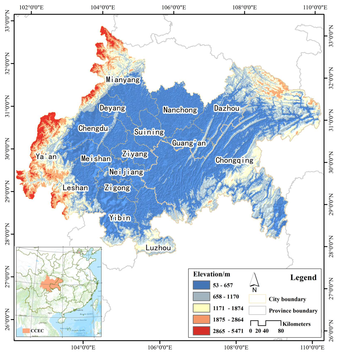
2.1. Study Area

The CCEC is situated in the upper reaches of the Yangtze River, within the Sichuan Basin. The region is deeply committed to green development, characterized by ongoing enhancements in the overall quality of its ecological environment. The foundation for ecological co-construction and environmental protection is robust and well established. Encompassing the central urban area of Chongqing, the planning scope of the CCEC extends to 27 districts and counties (Figure 1). In total, the CCEC spans an expansive area of 185,000 km2. The CCEC occupies a vital position as a barrier zone in the upper reaches of the Yangtze River. It plays a critical role in soil and water conservation, water resource preservation, and biodiversity protection within China. To ensure a comprehensive understanding of the ecosystem’s integrity and authenticity, this study encompasses all districts and counties of Chongqing Municipality within the analysis of the CCEC. Consequently, our study centers on the 15 prefecture-level cities in Sichuan Province and Chongqing Municipality as the study area.

2.2. Data Sources

The land use data for the CCEC in 2020 were collected from the GlobeLand30 database (http://www.globallandcover.com/; 30 m spatial resolution; accessed on 9 March 2022). Supported by China’s 863 Key Projects, the National Geomatics Center of China collaborated with 18 esteemed institutions to undertake pioneering research in global land cover mapping through advanced remote sensing technologies. By adopting the innovative Per-pixel Object Knowledge (POK) classification method, they achieved substantial reductions in errors arising from challenges like “same object, different spectra” or “different objects, same spectra”. The data product attained an exceptional level of excellence and consistency worldwide [32,33].

2.3. Habitat Quality Assessment

Habitat quality assessment relies on the Habitat Quality Module (HQM) integrated within the InVEST model [27]. This module operates on the basis of assumptions regarding the threats associated with specific land use types on the local ecosystem and habitat quality [28,34]. These underlying assumptions play a crucial role in discerning the potential level of threat that land use practices may pose to ecological resources. Within this module, we take into account the spatial decay of threats impacting the ecosystem. The parameter values of the model were determined by consulting the user guide of the InVEST model and referring to other studies (Supplementary Materials Tables S1 and S2) [27,35,36,37]. The outputs of the InVEST model were classified into five categories in ArcGIS (v10.6): optimal (0.8–1), high (0.6–0.8), medium (0.4–0.6), low (0.2–0.4), and unsuitable (0–0.2) [37,38].

2.4. Ecological Sources

Ecological sources play a pivotal role in the ecological security framework [4]. They constitute the foundation for maintaining ecosystem equilibrium, stability, and enhancing the vitality of the ecological environment, while also fostering biodiversity. Through judicious preservation and utilization of ecological sources, we can preemptively mitigate natural disasters, alleviate environmental pollution, and maintain ecological equilibrium, thus effectively safeguarding ecological security. Ecological sources encompass the elements, substances, or processes that play a pivotal role in upholding ecological balance and biodiversity within natural ecosystems. They are indispensable components that sustain ecosystem stability and functionality, thereby crucially contributing to the overall health and sustainability of the ecosystem. By offering diverse organisms suitable living conditions, such as access to food, water sources, habitat structures, and appropriate temperature ranges, ecological sources facilitate the existence and interaction of various species, ensuring they can thrive and reproduce within their specific habitats [2,4,13]. This study identified ecological sources as grids with a habitat suitability index surpassing 0.8 and a patch area exceeding 10 km2 [10,37].

2.5. Ecological Resistance Surface

The ecological resistance surface represents ecological elements that indicate the degree to which various geographic and environmental factors impede the movement or migration of organisms within an ecosystem. The ecological resistance surface is typically used to assess the ease or difficulty of biological movement between different regions and to assist in the planning of ecological connectivity networks, protection of species migration pathways, design of nature reserves, and other ecological management and planning activities. To assess landscape heterogeneity, resistance surface models like the Circuit Theory model and the Least-cost Distance model are commonly employed [39,40]. In this study, innovative methods were employed to incorporate the Habitat Suitability Index (HSI) with low motion resistance into the models. These models assign movement resistance values according to matrix permeability and compute diffusion resistance among populations. The calculation formula is shown below:
If HSI > Threshold → Suitable habitat → Resistance = 1
If   HSI   <   Threshold     Non - suitable   habitat / Matrix     Resistance = e ln 0 . 001 threshold × HSI × 1000
The InVEST model calculates the Habitat Suitability Index (HSI) to differentiate between suitable and unsuitable habitats. A threshold value of 0.8 is utilized, where HSI values equal to or greater than this threshold denote a suitable habitat, while values below it signify an unsuitable habitat.

2.6. Ecological Corridors

We utilized ecological sources and resistance surfaces to delineate ecological corridors within the CCEC. For this purpose, we employed the Circuit Theory model, which combines the notion of “circuits” with movement ecology. This model utilizes random walk theory to simulate the movement patterns of a random walker between source and target cells within the landscape. Through this approach, the Circuit Theory model identifies areas of notable ecological significance, such as wildlife migration routes and gene flow patterns [26,41,42]. In our study, the simulation of ecological corridors was conducted using Circuitscape 4.0 [40,42]. The Circuitscape running parameters were set as follows: (1) model mode: pairwise mode; (2) calculation mode: use average conductance instead of resistance for connections between cells, and run in low memory mode; (3) plot options: cumulative & max current maps, with focal node currents set to zero; (4) other model parameters are selected as default. The ecological corridors have been delineated in ArcGIS based on the direction and magnitude of cumulative current flow.

3. Results

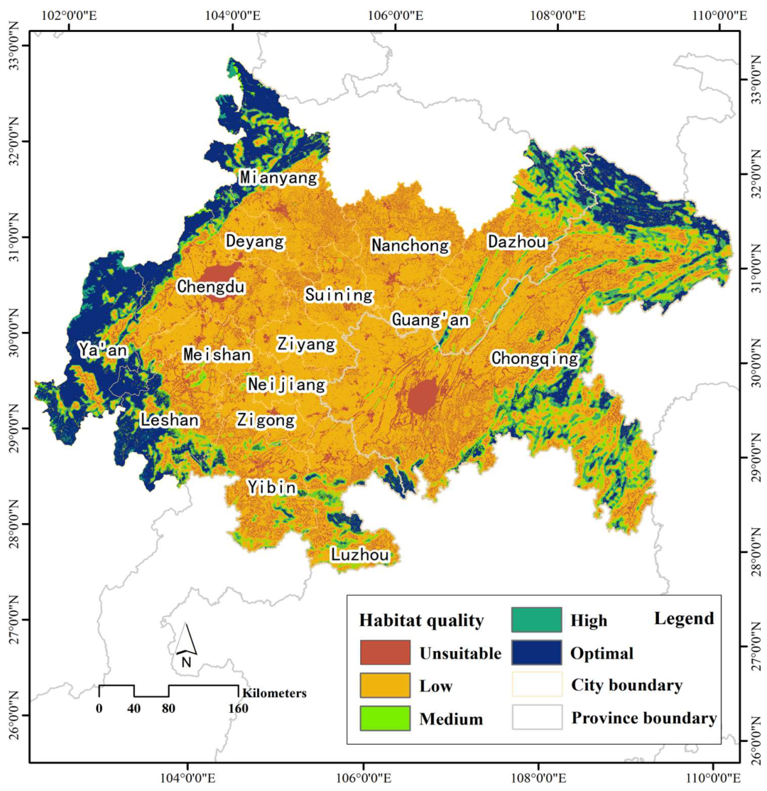
3.1. Spatial Variation of Habitat Quality

The findings derived from the InVEST model revealed distinct spatial variations in habitat quality within the CCEC. Notably, the western and northeastern regions exhibited higher habitat quality, while the central region exhibited relatively lower habitat quality, illustrating a clear pattern (Figure 2). The total habitat area within the CCEC encompassed 208,728.3 km2, which accounted for approximately 87.14% of the overall study area. Among these habitats, the areas designated as low, medium, high, and optimal quality accounted for 140,912.18 km2, 15,341.89 km2, 15,578.38 km2, and 36,895.85 km2, respectively, representing 58.83%, 6.40%, 6.50%, and 15.40% of the total study area. Notably, the cities of Ya’an, Mianyang, and Leshan featured larger proportions of optimal quality habitats compared to other cities, encompassing 61.72%, 33.68%, and 31.38% of their respective city areas. Conversely, the cities of Nanchong, Suining, and Ziyang exhibited lower habitat qualities, with low quality habitats comprising 79.73%, 83.86%, and 93.21% of their respective city areas (Table 1).

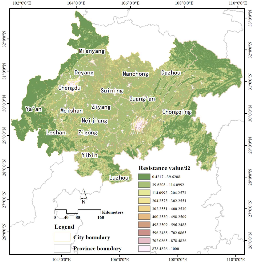
3.2. Spatial Distribution Characteristics of Habitat Landscape Resistance, Ecological Sources, and Landscape Connectivity

The central and southern regions of the CCEC exhibited significantly higher habitat landscape resistance values compared to the northwest and northeast regions. Habitats with higher landscape resistance were primarily distributed within Chengdu, Chongqing, and their surrounding regions (Figure 3). The areas with higher anthropogenic activities experienced more frequent disturbance and degradation of the ecological environment, which consequently led to severe habitat fragmentation and reduced connectivity among habitat patches. In contrast, habitats with lower landscape resistance were predominantly observed in the mountainous and river valley areas of the northwest and northeast regions (Figure 3).
The ecological sources area in the CCEC was 35,935.26 km2, accounting for approximately 15% of the total study area. Ecological sources were mainly distributed across 11 cities within the study area, with Ya’an, Mianyang, and Leshan having larger areas of ecological sources, accounting for 61.15%, 33.54%, and 30.46% of their respective city areas (Table 2). Continuous large-scale ecological sources have not yet been identified in Zigong, Neijiang, Nanchong, Suining, and Ziyang (Figure 4). The overall landscape connectivity in the CCEC exhibited a pattern of higher connectivity in the eastern and western parts and lower connectivity in the central and northern regions. Specifically, the central-southern parts of Ya’an, the northwestern part of Mianyang, the southwestern part of Leshan, and the southeastern part of Chongqing had relatively higher current values, indicating higher landscape connectivity compared to other regions (Figure 4).

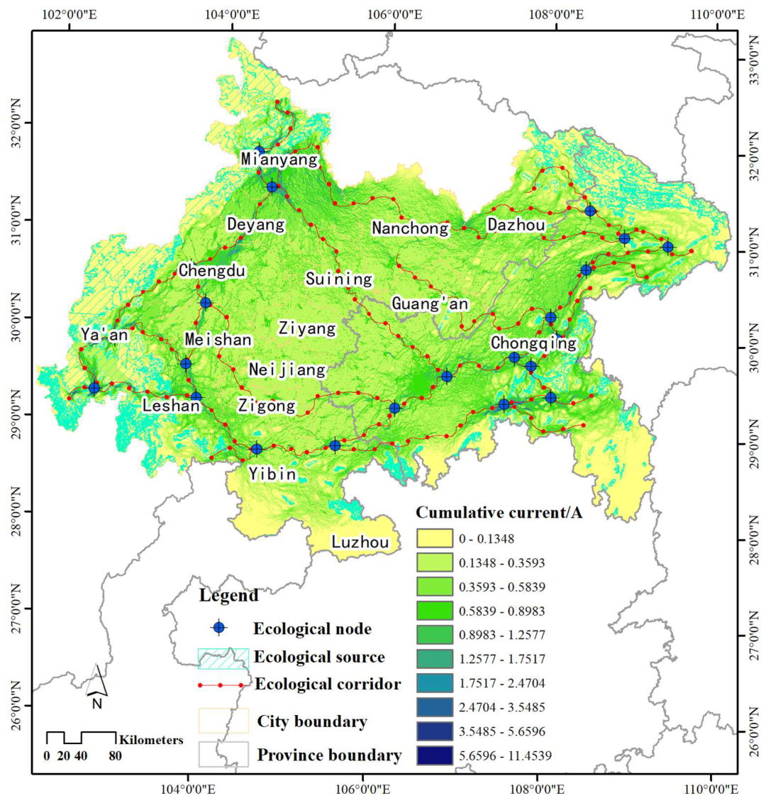
3.3. Characteristics of the Ecological Security Patterns

The results obtained from the Circuit Theory model revealed that the ecological security pattern in the CCEC was composed of multiple ecological nodes, ecological corridors, and ecological sources. Specifically, the pattern included 22 ecological nodes, 36 clusters of ecological corridors (with a total length of approximately 4525.28 km), and 136 ecological source patches (Figure 4). Ecological nodes were primarily located at the intersections of ecological corridors in the western and eastern regions, while no ecological nodes were identified in the central region. The ecological corridors exhibited a circular distribution, connecting the core ecological source areas in the western and eastern parts through the southern mountainous regions. The ecological corridors in the northeastern region mainly followed the mountainous areas, while those in the eastern region were distributed along the Yangtze River valley. From an ecological zoning perspective, the ecological security pattern in the CCEC was primarily composed of core ecological areas such as Qionglai Mountain–Minshan Mountain–Longquan Mountain in the west, Tiefeng Mountain–Fangdou Mountain–Qiyue Mountain–Wushan Mountain in the east and northeast, and Dalou Mountain in the southeast.

4. Discussion

The construction of a regional ecological security pattern generally relies on identifying optimal ecological networks, while scientifically planning and strictly protecting these networks serve as crucial means to balance regional economic development and ecological environmental conservation [11]. In this study, we employed an ecosystem services model to evaluate the spatial variations in habitat quality within the CCEC. Concurrently, we considered habitat quality, landscape resistance, and ecological sources as fundamental elements for constructing the ecological security pattern. Subsequently, utilizing the Circuit Theory model, we established the ecological security pattern in the CCEC. Numerous studies have utilized the HQM to evaluate the regional distribution of habitat quality and the spatiotemporal dynamics of habitats [11,28,34]. These investigations have utilized model outputs and environmental variables to identify core ecological sources. This approach is relatively scientific and mitigates the influence of subjective factors in ecological environmental assessments [37]. Furthermore, the research methodology for identifying ecological corridors and optimal ecological networks based on the Circuit Theory model is well developed, with some research outcomes demonstrating their effectiveness in the management of nature reserves and biodiversity conservation practices.
The identification of optimal ecological patterns is a fundamental requirement for constructing ESPs [4,13]. Their implementation facilitates the maintenance and regulation of ecological processes while enhancing ecosystem functions [11]. This study, by examining spatial variations in habitat quality, ecological corridors, and related characteristics, contributes significantly to the scientific foundation for ESP construction in the CCEC. By delineating core ecological sources primarily concentrated in the mountainous regions of the west and northeast, and identifying ecological corridors aligned along the course of the mountainous Yangtze River Valley, this research underscores the critical role of these areas as key ecological regions linking the eastern and western parts of the CCEC. These findings highlight the necessity for implementing rigorous ecosystem protection measures in this region. Furthermore, the integration of these spatial insights into ecosystem planning and management strategies is essential to ensure the resilience and sustainability of the CCEC’s ecological landscape. Such efforts are crucial for maintaining biodiversity, supporting ecosystem services, and safeguarding the long-term ecological integrity of the region.
The construction of ESPs depends on adhering to the principles of ecology [10]. This entails establishing regional ecological security patterns to manage ecological processes and achieve rational allocation of natural resources and infrastructure within the area [13]. In this study, we adopted a problem-oriented and method-based research framework, focusing on integrating interdisciplinary knowledge, methodologies, and diverse data sources. Such an approach aids in exploring the complexity of ecosystems and provides sustainable development management strategies. Carefully selected ecological significance indexes addressed the unique ecological issues and geographical variations in the CCEC. To construct ESPs for the CCEC, an interdisciplinary approach was employed, incorporating landscape management knowledge and comprehensive methodologies. This approach proved beneficial in ensuring ecological security in Southwest China and fostering a harmonious coexistence between humans and nature. By combining expertise from multiple fields, a holistic understanding of the region’s ecological dynamics and challenges was achieved. This approach not only facilitated the development of ESPs specific to the CCEC but also contributed to the broader goal of promoting sustainable practices and ecological well-being in the region.
We not only evaluated the spatial distribution differences in habitat quality but also identified critical ecological corridors. It has been demonstrated that targeted protection is more effective than random implementation of conservation plans [43], particularly in developing countries [11]. However, determining priority conservation areas is highly challenging due to spatial heterogeneity within ecosystems and geographical environments. While using the InVEST model and ecological network structure analysis to identify and assess ESPs is relatively objective and scientific, these methods primarily focus on ecological attributes and often overlook the impact of human activities on the ecosystem [10]. In this study, we endeavored to construct a scientifically informed ecological security pattern using the ecosystem services model and Circuit Theory model, providing a reference for scientifically identifying priority conservation areas for ecological corridors. This approach has the advantage of reducing subjectivity and uncertainty in ecosystem protection efforts.
Our study conducted a comprehensive analysis of habitat quality, ecological corridors, and spatial heterogeneity within the CCEC, providing in-depth insights and scientific support for ecological conservation decision-makers. Through systematic evaluation of the ESPs, we gained a thorough understanding of the structure and function of the local ecosystem, thereby offering crucial information for future ecological conservation planning and management. Our research findings identified the ecological core areas, connecting areas, and peripheral areas of CCEC, thus providing a scientific basis for delineating and planning future protected areas. Additionally, the study on ecological corridors and spatial heterogeneity serves as an important reference for the rational planning and design of ecological, residential, and industrial spaces. The value of these spatial planning endeavors lies not only in safeguarding the integrity and stability of ecosystems but also in fostering harmonious coexistence between humans and the natural environment, thereby promoting sustainable development and the establishment of an ecological civilization.
However, it should be noted that the factors influencing the ESPs are diverse and complex, encompassing natural environmental changes, human activities, and climate variations, among others. While our study made efforts to consider some of these factors, it did not comprehensively encompass all potential influencing factors. Moreover, due to limitations in data availability, we were unable to fully account for the impacts of socio-economic factors on the ESPs. Additionally, since subjective scoring of parameters was employed in the InVEST model, it may introduce certain degrees of evaluation bias. Nevertheless, these limitations do not invalidate the scientific rigor of our study. On the contrary, our research still serves as a significant reference for the identification and understanding of ESPs. For future research endeavors, we recommend not only continuing to refine the quality of models and data but also striving to collect more extensive and comprehensive data, particularly through in-depth investigations of threats beyond the study area. This will facilitate a better understanding and interpretation of the driving mechanisms behind the changes in ecological security landscapes.

5. Conclusions

Our study has uncovered substantial spatial disparities in the distribution of ecological nodes, corridors, and sources, which are pivotal in shaping the ESPs within the CCEC. These spatial variations are influenced by differential natural environmental factors and varying degrees of human disturbances. Particularly in the western and northeastern mountainous regions, endowed with favorable natural ecological conditions and relatively low human interference, we observe a denser presence of ecological nodes and corridors, alongside expansive ecological sources, thus forming a contiguous distribution pattern. Consequently, these regions exhibit notably elevated levels of ecological security compared to the central area. Moreover, the western and northeastern regions, distinguished by their relatively high habitat quality, boast extensive forest cover and rich biodiversity. In contrast, the hilly areas of the southeast demonstrate moderate levels of ecological security, facing dual challenges from desertification and human disturbance. Consequently, habitat fragmentation is pronounced, leading to a decline in habitat quality. Areas exhibiting the lowest levels of ecological security are predominantly situated in the central region, particularly in the vicinity of Chengdu and Chongqing. These areas are characterized by high population density, extensive road networks, urban sprawl, and intensive agricultural activities. Furthermore, the ecosystems and surface vegetation in these regions tend to be more homogenized, rendering them highly susceptible to external disturbances. Expanding upon these findings, our study underscores the intricate interplay between natural and anthropogenic factors in shaping ecological security landscapes. These insights are essential for devising targeted conservation strategies and sustainable development plans within the CCEC.
To enhance the ecological security of the CCEC, it is essential to prioritize the management and protection of core ecological source areas. These areas, including the Qionglai Mountains, Min Mountains, Dalou Mountains, Daba Mountains, Wushan Mountains, and other significant ecological regions, play a crucial role in maintaining the overall ecological balance. Given that forestland constitutes the largest proportion of ecological sources, it is imperative to focus on improving the habitat quality and connectivity of forests in these regions and their adjacent ecological functional zones. Strategies such as controlling urban expansion, revitalizing and upgrading developed areas in the regions, and increasing the carrying capacity of the ecosystem should be employed. Additionally, restoring exposed mountains within forested areas can significantly enhance the ecological security within these ecological sources. By implementing restoration measures, the internal ecological balance of the core areas can be preserved and safeguarded. Furthermore, it is vital to promote the integration of ecological and environmental protection across the Chengdu–Chongqing region, with particular emphasis on strengthening the conservation of ecological corridors and nodes. Establishing ecological corridors that connect the Qionglai Mountains–Min Mountains ecological region in the west, the Dalou Mountains ecological region in the south, the Wuling Mountains ecological region in the southeast, and the Daba Mountains–Wushan Mountains ecological region in the northeast is crucial. These ecological corridors will facilitate the movement and gene exchange of species, fostering a healthy and sustainable ecosystem within the four major ecological regions.

Supplementary Materials

The following supporting information can be downloaded at: https://www.mdpi.com/article/10.3390/su16072835/s1, Table S1. Influence range and weight of threat factors; Table S2. Sensitivity of the different habitats to the threat factors.

Author Contributions

Conceptualization, Q.W. and Y.D.; methodology, Q.W. and Y.D.; software, Y.D.; validation, Q.W.; writing—original draft preparation, Q.W.; writing—review and editing, Q.W. and Y.D.; funding acquisition, Q.W. All authors have read and agreed to the published version of the manuscript.

Funding

This research was funded by the Scientific Project conducted by the Development Research Center for Small and Medium-sized Cities within the Chengdu–Chongqing Twin City Economic Circle (Grant/Award Number: 23CRKCYPT01) and the Humanities and Social Sciences Research Project of Chongqing Municipal Education Commission (The Dynamic Evaluation and Enhancement Pathways of Ecological Security of Cultivated Land in the Chengdu–Chongqing Twin City Economic Circle).

Institutional Review Board Statement

Not applicable.

Informed Consent Statement

Not applicable.

Data Availability Statement

Data are contained within the article.

Conflicts of Interest

The authors declare no conflicts of interest.

References

  1. Feng, W.; Liu, Y.; Qu, L. Effect of land-centered urbanization on rural development: A regional analysis in China. Land Use Policy 2019, 87, 104072. [Google Scholar] [CrossRef]
  2. Wanghe, K.; Guo, X.; Wang, M.; Zhuang, H.; Ahmad, S.; Khan, T.U.; Li, K. Gravity model toolbox: An automated and open-source ArcGIS tool to build and prioritize ecological corridors in urban landscapes. Glob. Ecol. Conserv. 2020, 22, e01012. [Google Scholar] [CrossRef]
  3. Feist, B.E.; Buhle, E.R.; Baldwin, D.H.; Spromberg, J.A.; Damm, S.E.; Davis, J.W.; Scholz, N.L. Roads to ruin: Conservation threats to a sentinel species across an urban gradient. Ecol. Appl. 2017, 27, 2382–2396. [Google Scholar] [CrossRef] [PubMed]
  4. Peng, J.; Yang, Y.; Liu, Y.; Du, Y.; Meersmans, J.; Qiu, S. Linking ecosystem services and circuit theory to identify ecological security patterns. Sci. Total Environ. 2018, 644, 781–790. [Google Scholar] [CrossRef]
  5. Dong, L.; Liu, J.; Du, X.; Dai, C.; Liu, R. Simulation-based risk analysis of water pollution accidents combining multi-stressors and multi-receptors in a coastal watershed. Ecol. Indic. 2018, 92, 161–170. [Google Scholar] [CrossRef]
  6. Teixeira, L.; Tisovec-Dufner, K.C.; Marin GD, L.; Marchini, S.; Dorresteijn, I.; Pardini, R. Linking human and ecological components to understand human–wildlife conflicts across landscapes and species. Conserv. Biol. 2021, 35, 285–296. [Google Scholar] [CrossRef]
  7. McCarty, J.P. Ecological consequences of recent climate change. Conserv. Biol. 2001, 15, 320–331. [Google Scholar] [CrossRef]
  8. Díaz, S.; Fargione, J.; Chapin, F.S., III; Tilman, D. Biodiversity loss threatens human well-being. PLoS Biol. 2006, 4, e277. [Google Scholar] [CrossRef]
  9. Liu, C.; Li, W.; Xu, J.; Zhou, H.; Li, C.; Wang, W. Global trends and characteristics of ecological security research in the early 21st century: A literature review and bibliometric analysis. Ecol. Indic. 2022, 137, 108734. [Google Scholar] [CrossRef]
  10. Zhang, J.; Zhang, P.; Wang, R.; Liu, Y.; Lu, S. Identifying the coupling coordination relationship between urbanization and forest ecological security and its impact mechanism: Case study of the Yangtze River Economic Belt, China. J. Environ. Manag. 2023, 342, 118327. [Google Scholar] [CrossRef]
  11. Xiao, S.; Wu, W.; Guo, J.; Ou, M.; Pueppke, S.G.; Ou, W.; Tao, Y. An evaluation framework for designing ecological security patterns and prioritizing ecological corridors: Application in Jiangsu Province, China. Landsc. Ecol. 2020, 35, 2517–2534. [Google Scholar] [CrossRef]
  12. Esbah, H.; Cook, E.A.; Ewan, J. Effects of increasing urbanization on the ecological integrity of open space preserves. Environ. Manag. 2009, 43, 846–862. [Google Scholar] [CrossRef] [PubMed]
  13. Peng, J.; Pan, Y.; Liu, Y.; Zhao, H.; Wang, Y. Linking ecological degradation risk to identify ecological security patterns in a rapidly urbanizing landscape. Habitat Int. 2018, 71, 110–124. [Google Scholar] [CrossRef]
  14. Zhao, Y.Z.; Zou, X.Y.; Cheng, H.; Jia, H.K.; Wu, Y.Q.; Wang, G.Y.; Zhang, C.L.; Gao, S.Y. Assessing the ecological security of the Tibetan plateau: Methodology and a case study for Lhaze County. J. Environ. Manag. 2006, 80, 120–131. [Google Scholar] [CrossRef] [PubMed]
  15. Huang, J.; Hu, Y.; Zheng, F. Research on recognition and protection of ecological security patterns based on circuit theory: A case study of Jinan City. Environ. Sci. Pollut. Res. 2020, 27, 12414–12427. [Google Scholar] [CrossRef] [PubMed]
  16. Wang, C.; Yu, C.; Chen, T.; Feng, Z.; Hu, Y.; Wu, K. Can the establishment of ecological security patterns improve ecological protection? An example of Nanchang, China. Sci. Total Environ. 2020, 740, 140051. [Google Scholar] [CrossRef] [PubMed]
  17. Zhang, L.; Peng, J.; Liu, Y.; Wu, J. Coupling ecosystem services supply and human ecological demand to identify landscape ecological security pattern: A case study in Beijing–Tianjin–Hebei region, China. Urban Ecosyst. 2017, 20, 701–714. [Google Scholar] [CrossRef]
  18. Guo, R.; Wu, T.; Liu, M.; Huang, M.; Stendardo, L.; Zhang, Y. The construction and optimization of ecological security pattern in the Harbin-Changchun urban agglomeration, China. Int. J. Environ. Res. Public Health 2019, 16, 1190. [Google Scholar] [CrossRef] [PubMed]
  19. Wanghe, K.; Guo, X.; Luan, X.; Li, K. Assessment of urban green space based on bio-energy landscape connectivity: A case study on Tongzhou district in Beijing, China. Sustainability 2019, 11, 4943. [Google Scholar] [CrossRef]
  20. Wang, Y.; Pan, J. Building ecological security patterns based on ecosystem services value reconstruction in an arid inland basin: A case study in Ganzhou District, NW China. J. Clean. Prod. 2019, 241, 118337. [Google Scholar] [CrossRef]
  21. Xu, J.; Fan, F.; Liu, Y.; Dong, J.; Chen, J. Construction of ecological security patterns in nature reserves based on ecosystem services and circuit theory: A case study in Wenchuan, China. Int. J. Environ. Res. Public Health 2019, 16, 3220. [Google Scholar] [CrossRef] [PubMed]
  22. Liu, Y.; Zhao, C.; Liu, X.; Chang, Y.; Wang, H.; Yang, J.; Yang, X.; Wei, Y. The multi-dimensional perspective of ecological security evaluation and drive mechanism for Baishuijiang National Nature Reserve, China. Ecol. Indic. 2021, 132, 108295. [Google Scholar] [CrossRef]
  23. Balasooriya BL, W.K.; Samson, R.; Mbikwa, F.; Boeckx, P.; Van Meirvenne, M. Biomonitoring of urban habitat quality by anatomical and chemical leaf characteristics. Environ. Exp. Bot. 2009, 65, 386–394. [Google Scholar] [CrossRef]
  24. Hirzel, A.H.; Hausser, J.; Chessel, D.; Perrin, N. Ecological-niche factor analysis: How to compute habitat-suitability maps without absence data? Ecology 2002, 83, 2027–2036. [Google Scholar] [CrossRef]
  25. Nematollahi, S.; Fakheran, S.; Kienast, F.; Jafari, A. Application of InVEST habitat quality module in spatially vulnerability assessment of natural habitats (case study: Chaharmahal and Bakhtiari province, Iran). Environ. Monit. Assess. 2020, 192, 487. [Google Scholar] [CrossRef] [PubMed]
  26. Dai, Y.; Peng, G.; Wen, C.; Zahoor, B.; Ma, X.; Hacker, C.E.; Xue, Y. Climate and land use changes shift the distribution and dispersal of two umbrella species in the Hindu Kush Himalayan region. Sci. Total Environ. 2021, 777, 146207. [Google Scholar] [CrossRef]
  27. Sharp, R.; Tallis, H.; Ricketts, T.; Guerry, T.; Wood, S.A. InVEST 3.7.0. The Natural Capital Project; Stanford University: Stanford, CA, USA, 2018. [Google Scholar]
  28. Zhong, L.; Wang, J. Evaluation on effect of land consolidation on habitat quality based on InVEST model. Trans. Chin. Soc. Agric. Eng. 2017, 33, 250–255. [Google Scholar]
  29. Huang, J.; Huang, J.; Liu, C.; Zhang, J.; Lu, X.; Ma, K. Diversity hotspots and conservation gaps for the Chinese endemic seed flora. Biol. Conserv. 2016, 198, 104–112. [Google Scholar] [CrossRef]
  30. Lu, S.; Tang, X.; Guan, X.; Qin, F.; Liu, X.; Zhang, D. The assessment of forest ecological security and its determining indicators: A case study of the Yangtze River Economic Belt in China. J. Environ. Manag. 2020, 258, 110048. [Google Scholar] [CrossRef]
  31. Li, W.; Wang, Y.; Xie, S.; Cheng, X. Coupling coordination analysis and spatiotemporal heterogeneity between urbanization and ecosystem health in Chongqing municipality, China. Sci. Total Environ. 2021, 791, 148311. [Google Scholar] [CrossRef]
  32. Chen, J.; Cao, X.; Peng, S.; Ren, H. Analysis and applications of GlobeLand30: A review. ISPRS Int. J. Geo-Inf. 2017, 6, 230. [Google Scholar] [CrossRef]
  33. Chen, J.; Chen, J.; Liao, A.; Cao, X.; Chen, L.; Chen, X.; He, C.; Han, G.; Peng, M.; Mills, J.; et al. Global land cover mapping at 30 m resolution: A POK-based operational approach. ISPRS J. Photogramm. Remote Sens. 2015, 103, 7–27. [Google Scholar] [CrossRef]
  34. Sallustio, L.; De Toni, A.; Strollo, A.; Di Febbraro, M.; Gissi, E.; Casella, L.; Geneletti, D.; Munafò, M.; Vizzarri, M.; Marchetti, M. Assessing habitat quality in relation to the spatial distribution of protected areas in Italy. J. Environ. Manag. 2017, 201, 129–137. [Google Scholar] [CrossRef] [PubMed]
  35. Nelson, E.; Mendoza, G.; Regetz, J.; Polasky, S.; Tallis, H.; Cameron, D.; Chan, K.M.; Daily, G.C.; Goldstein, J.; Shaw, M.; et al. Modeling multiple ecosystem services, biodiversity conservation, commodity production, and tradeoffs at landscape scales. Front. Ecol. Environ. 2009, 7, 4–11. [Google Scholar] [CrossRef]
  36. Qiu, J.; Turner, M.G. Spatial interactions among ecosystem services in an urbanizing agricultural watershed. Proc. Natl. Acad. Sci. USA 2013, 110, 12149–12154. [Google Scholar] [CrossRef] [PubMed]
  37. Zheng, Q.; Shen, M.; Zhong, L. Construction of ecological security pattern in Pudacuo National Park. Acta Ecol. Sin. 2021, 41, 874–885. [Google Scholar]
  38. Li, C.; Wang, J.; Liu, X.; Xu, K. Construction of Karst Landscape Ecological Security Pattern Based on Conflict between Human and Nature in Puzhehei. Sustainability 2024, 16, 908. [Google Scholar] [CrossRef]
  39. Adriaensen, F.; Chardon, J.P.; De Blust, G.; Swinnen, E.; Villalba, S.; Gulinck, H.; Matthysen, E. The application of ‘least-cost’modelling as a functional landscape model. Landsc. Urban Plan. 2003, 64, 233–247. [Google Scholar] [CrossRef]
  40. McRae, B.H.; Dickson, B.G.; Keitt, T.H.; Shah, V.B. Using circuit theory to model connectivity in ecology, evolution, and conservation. Ecology 2008, 89, 2712–2724. [Google Scholar] [CrossRef]
  41. Li, J.; Xu, J.; Chu, J. The construction of a regional ecological security pattern based on circuit theory. Sustainability 2019, 11, 6343. [Google Scholar] [CrossRef]
  42. Du, L.; Hou, Y.; Zhong, S.; Qu, K. Identification of Priority Areas for Ecological Restoration in Coal Mining Areas with a High Groundwater Table Based on Ecological Security Pattern and Ecological Vulnerability. Sustainability 2023, 16, 159. [Google Scholar] [CrossRef]
  43. Williams, J.C.; Snyder, S.A. Restoring habitat corridors in fragmented landscapes using optimization and percolation models. Environ. Model. Assess. 2005, 10, 239–250. [Google Scholar] [CrossRef]
Figure 1. Geographical location of the Chengdu–Chongqing Economic Circle (CCEC), Southwestern China.
Sustainability 16 02835 g001
Figure 2. Spatial distribution of habitat quality in the CCEC.
Sustainability 16 02835 g002
Figure 3. Spatial distribution of ecological resistance in the CCEC.
Sustainability 16 02835 g003
Figure 4. Spatial distribution of ecological security patterns in the CCEC.
Sustainability 16 02835 g004
Table 1. Characteristics of habitats of different quality in the CCEC.
Administrative AreaUnsuitable
Habitat/km2
Suitable Habitat/km2The Proportion of the
Administrative Area Occupied by Optimal Habitat/%
LowMediumHighOptimal
Ya’an282.592743.90904.161829.449286.4361.72
Mianyang1957.308810.86903.191725.276803.8833.68
Leshan1227.955363.761278.16858.643992.2631.38
Meishan776.805066.44138.03157.80995.5513.95
Chengdu3249.378469.69388.06321.791906.6113.30
Chongqing11,139.7446,273.677616.857389.619982.3112.11
Deyang807.664103.52118.98248.26633.4910.72
Dazhou1852.859731.031513.841815.521687.3810.16
Luzhou1700.387801.021104.89541.741084.318.86
Yibin2344.328879.831051.02550.62457.563.44
Guang’an699.935278.05188.47108.4764.801.02
Zigong503.983795.7858.8722.140.770.02
Neijiang509.184815.9355.065.750.000.00
Nanchong2511.339948.7114.023.330.500.00
Suining850.864463.038.290.000.000.00
Ziyang390.675366.960.000.000.000.00
Table 2. Spatial distribution characteristics of ecological sources in the CCEC.
Administrative AreaArea of Ecological Source/km2Proportion of the Administrative Area
Occupied by Ecological Source/%
Ya’an9201.6661.15
Mianyang6774.4833.54
Leshan3874.2330.46
Meishan989.0213.86
Chengdu1895.3913.22
Chongqing9515.7211.55
Deyang627.1910.61
Dazhou1608.949.69
Luzhou991.008.10
Yibin392.832.96
Guang’an64.801.02
Disclaimer/Publisher’s Note: The statements, opinions and data contained in all publications are solely those of the individual author(s) and contributor(s) and not of MDPI and/or the editor(s). MDPI and/or the editor(s) disclaim responsibility for any injury to people or property resulting from any ideas, methods, instructions or products referred to in the content.

