Abstract
This article addresses the sustainable urbanization model of urban valley-bottom areas, focusing on the Jaguaré stream basin in São Paulo, Brazil. It tackles the challenge of integrating environmental criteria into the management of urbanized watersheds to promote urban and environmental resilience through adaptive infrastructures. São Paulo, the largest and most populous city in Brazil, has often overlooked the natural characteristics of watersheds, resulting in significant flooding and necessitating a reassessment of urban practices. The study, through the analysis of a referential project, qualitative analyses, and geoprocessing techniques, proposes an urbanization model in valley bottom areas that combines adaptive infrastructures—green-blue and gray infrastructures. It highlights the importance of a systemic, transdisciplinary, and integrated approach that considers the political-administrative, environmental, urbanistic, and infrastructural dimensions to address the challenges posed by climate change and urbanization. Specific recommendations are presented to adapt urbanized valley-bottom areas, emphasizing nature-based solutions and community participation in the management of hydrological risks towards the promotion of sustainable and fair urban spaces.
1. Introduction
The UN Sixth Report of the Intergovernmental Panel on Climate Changes (IPCC-AR6) evinces that global climate change and extreme events such as heat waves, intense rainfalls, downpours, and droughts are undeniably influenced by human activity [1,2].
The relationship between climate change and urban occupation currently constitutes one of the major challenges in the development of public policies, requiring systemic, transdisciplinary, and multisectoral approaches in different scales, as well as examining the effects of anthropic actions on natural resources [3] and on the worsening of social disparities, with an emphasis on less favored populations [4,5].
In Brazilian cities, facing this challenge requires confronting several sectoral and technocratic public policies implemented over a century, as well as proposing solutions that integrate the city, the society, and the environment.
The main gaps in the context of Brazilian cities regarding climate change and urbanization can be summarized as follows:
- Integrated understanding of impacts: There is a lack of integrated understanding of how urbanization affects and is affected by extreme weather events. This includes the need for studies that simultaneously address climate, urban, and socio-economic dimensions.
- Local data and research: There is a shortage of detailed local data and research that allow for precise analysis of the effects of climate change on Brazilian cities. This scarcity hampers adaptive urban planning and the formulation of effective public policies.
- Sustainable urbanization practices: There is a gap in the implementation of urbanization practices that consider environmental sustainability, especially in the management of permeable areas and the preservation of urban green spaces.
- Risk area management: Inadequate management of risk areas, particularly flood-prone valley bottoms, reflects a significant gap. Often, these areas are improperly urbanized without considering associated risks.
- Adaptive infrastructure: There is an absence of urban infrastructure designed to be resilient and adaptive to climate change, including efficient drainage systems and measures to mitigate heat islands.
- Integrated public policies: There is a need for more integrated public policies that simultaneously address urbanization, climate change, and social justice. Fragmented policies hinder effective approaches to mitigate and adapt to climate impacts.
- Community participation and awareness: There is a gap in community participation and awareness of the interactions between urbanization, climate change, and their local impacts. Increasing awareness and involving local communities are essential for promoting urban resilience.
These gaps highlight the urgent need for a holistic and integrated approach in urban planning and management, considering the complex interactions between urbanization, climate change, and social inequalities to promote more resilient and sustainable cities in Brazil. Far from attempting to address all these gaps, this article will focus on the emerging problems related to valley-bottom areas, with an emphasis on the management of hydrological risk areas and the possibilities of adaptive infrastructure, especially green and blue.
In valley-bottom areas, frequent flooding resulting from the overflow of rivers during periods of more intense rain could be normal if floodable areas remained preserved, that is, permeable and vegetated. However, the urbanization model of several Brazilian cities has taken up space in river floodplain areas for a much-desired “urban development”. In several cities, the management of urban waters throughout the 20th century has adopted a purely “technocratic” approach, focusing on the construction of large infrastructure works for the rapid drainage of rainwater, river covering and/or channeling, and road construction on valley bottoms. Thus, greater water flow and the mobility of people and goods were prioritized over environmental quality.
In São Paulo, the largest and most populated Brazilian city, with an urbanized area of 914.56 km2, a population of 11,451,245 inhabitants, and a demographic density around 7527.76 inhabitants/km2; main rivers have had their geomorphologies deeply altered to control flooding and quickly remove wastewater, according to a model that constituted an urban and infrastructure solution at the same time [6,7] Channeling riverbeds and building riverside avenues, or even “erasing” several watercourses and replacing them with road systems, were predominant solutions in valley bottoms, turning rivers into elements of urban infrastructure. Combined with this model, “urban voids” that result from the straightening of riverbeds were occupied by precarious settlements in many places, contributing to the recurrent worsening of inundations, causing hydrological disasters with major impacts.
Such procedures are seen as structural in nature and are part of technical solutions with heavy infrastructure artifacts—termed gray infrastructure by many authors—and have not solved the conflict between urbanization and floods in the medium and long term.
Due to the limitations and inefficiency of the current model, public policy, scholars, and creators have been advocating for a “non-conventional” approach, with a focus on regeneration, preservation, environmental conservation, and sustainable managing of water and river landscapes in valley-bottom areas. This concept of integrated management of water resources (GIRH), also known as risk management, enables the necessary sustainable environmental development for city infrastructure [8] one that pursues urban and environmental resilience from a perspective that integrates the population, rivers, and floodable areas [7,9,10,11].
In general, such an approach regards the hydrographical basin as a planning and management unit, combining structural measures and infrastructural engineering solutions with non-structural measures and, when necessary, the implementation of Nature-based Solutions (NbS) and short and long-term institutional preventive actions —environmental monitoring, regulation, control, and education [8,12]. In other words, it is an approach that conciliates “gray and green-blue infrastructures” in favor of an “adaptive infrastructure”.
This article reflects on the urbanization model of valley-bottom areas, with an emphasis on the case study of the Jaguaré stream, located in the southwest zone of the city of São Paulo. From a series of reference plans and successful projects, which relied on the concept of integrated water resources and risk management, we seek to build a set of principles and recommendations for implementing an environmental approach in the adjustment and adaptation of infrastructure and land use in this watershed.
The study is the product of academic research advocating for an integrated and systemic urban planning process. It considers the hydrological and socio-environmental characteristics of river basins, aiming to promote their sustainability and regenerate watercourses as structural elements of the landscape. This analysis is conducted in light of four dimensions of sustainability: political-administrative, environmental, urbanistic and infrastructural.
The text is organized into five parts: (1) theoretical framework—a brief revision of literature, highlighting concepts, theories, and studies; (2) methodology describing the methodological procedures of the study that gave origin to the article, considering its replicability; (3) results and discussion—main results of the study and highlighting the case study of the Jaguaré stream, in São Paulo; (4) synthesis of the main recommendations that can be applied to other valley-bottom areas with similar characteristics; (5) conclusion, which sums up the major features of the article, reinforcing the need to build sustainable paths that promote engagement between the population and urban rivers.
2. Theoretical Framework
The urban transformations caused by the rapid expansion of cities pose significant challenges for environmental sustainability, especially regarding water resource management and flood control. Intensive urbanization, with its disorderly densification and occupation of naturally flood-prone areas, such as floodplains and valley bottoms, requires a critical re-evaluation of traditional drainage strategies and urban water management. These strategies, historically focused on rapidly removing rainwater to prevent flooding in urbanized areas, often do not consider the multifaceted benefits of water for urban ecosystems and quality of life of the population.
Traditional infrastructural drainage systems based on the quick removal of rainwater consider this precious resource as a mere residue. They aim to reduce the impacts of water runoff with structural measures composed of robust elements to conduct rainwater, applied in predominantly local solutions. Although they do reduce conflicts between drainage and urbanization in affected areas, they often transfer floods to downstream areas. These problems are worsened by the occupation of originally floodable areas in a strategy of “space allocation” [13] quite common in the urbanization processes. The occupation of floodplains and the inappropriate densification of valley-bottom areas, supported by the installation of large infrastructures, jeopardize the natural capacity of retaining rainwater, making it necessary to find other places to this end.
In general, these built systems are considered a kind of defense against risks, but they do not consider the complexities of rapid urbanization and the several socio-economic and biophysical processes involved [14,15]. They include physical infrastructures, management, and urban services, which are subject to external governance and whose interactions can encompass different areas in local and remote operations, often leading to unintended consequences due to a lack of understanding of systemic connections. The ability to plan and govern with a systemic, intersectoral, and multi-scaled approach is of major importance to deal with this complexity [14,16] and to reach the desired urban sustainability.
Flood control exclusively by means of local structural measures fails and is easily overcome by trying to change rivers’ natural state to reduce flooding. This control requires huge investments in ever-larger works that are never successful [5,17,18,19,20,21,22].
Urban rainwater management has become more and more complex in recent decades, evolving from flood control and risk reduction to consider rainwaters as a resource subject to quality control and capable of restoring flow regimes and promoting microclimatic resilience in the current context of climate change [23].
Faced with the limitations of traditional drainage systems, which often result in transferring flood problems downstream and do not contribute to urban sustainability, there is a need to explore innovative and unconventional approaches. In this context, “adaptive infrastructure”, which encompasses elements of both green and blue infrastructure, emerges as a promising solution. Wright and Furlong [24] and McDonald et al. [25] emphasize that integrating these elements into the urban fabric not only mitigates flood risks but also promotes biodiversity, improves air and water quality, and enhances aesthetics and well-being in urban spaces.
According to Fletcher at al [23] the implementation of green and blue infrastructures goes beyond stormwater management, contributing to the restoration of natural flow regimes and fostering microclimatic resilience in the face of climate change. These adaptive strategies are essential for addressing the challenges posed by urbanization and climate change in an integrated and sustainable manner [26].
Therefore, the adoption of drainage systems that combine green and blue infrastructure, along with community participation and a systemic approach in urban planning, is essential to promote a harmonious coexistence between the city and its water resources, aligning urban development with sustainability principles [27,28,29].
This way, methods and strategies that adopt nature conservation and adaptation of urban areas to flooding as a principle, establishing parameters of coexistence with flooding situations, of evaluating and managing risks, and of recovering after extreme events have been emerging as much more resilient and efficient [30].
They include approaches that adopt adaptability and resilience to floods as a paradigm to reduce their adverse consequences, adapting cities and buildings to flooding events in view of the regime of climate change and extreme meteorological phenomena [30,31]. Such changes include the integration of naturally floodable areas as a premise, as well as guidelines for planning urban land use and occupation; they unfold in projects for the recovery of waterfronts, implementation of linear parks [19,32,33,34,35] and other strategies that value “Nature-based Solutions”.
As for the environmental approach, urban drainage unfolds into two systems that operate in an integrated and simultaneous way: the gray and the green-blue systems. The former is constituted by networks of traditional heavy infrastructure artifacts—reservoirs, dikes, and watercourse channels—and the latter is formed by natural drainage and infiltration systems—natural riverbeds, floodable floodplains, and green and permeable areas [12,36,37].
According to McDonald et al. [24] green infrastructure, which includes parks, rain gardens, green roofs, and other strategically planned vegetations, can play a vital role in reducing surface runoff, improving air quality, and promoting cooler and more pleasant urban spaces. Additionally, blue infrastructure, which encompasses aquatic elements, such as detention ponds, bio-swales, and constructed wetlands, is essential for effective water management.
The environmental approach operations are developed through mixed systems of gray infrastructure—channels, pipes, and —and blue-green infrastructure—beds and ditches, lakes and buffering areas, and vegetated floodplains. By superficially conducing or damming rainwater in an association with green spaces, natural drainage networks, buried and hidden by traditional systems, are made visible and tangible in urban environments.
Gray infrastructure networks are usually located and concentrated in valley-bottom areas, while green-blue infrastructure networks are spread throughout the whole river basin surface. In this way, to create resilient, low-maintenance, and failure-resistant systems, it is advisable to explore the qualities and characteristics of both and, if necessary, to combine their possibilities.
Promoting a systemic approach is crucial to face up to socio-environmental conflicts generated by urbanization processes, which do not manifest in the same way throughout the territory. This implies understanding the origin of the current systems structure—social, economic, ecological, and political—within and beyond the city, exploring new arrangements and new forms for a possible future.
The environmental strategy approach for urban infrastructure consists in promoting a co-design and co-production process that presents innovative ideas and solutions, combined with collective adherence to goals shared by a wide range of decision-makers and other interested parties regarding urban planning and management, either in the public, private, or community sectors [14,15]. An effective systemic approach can empower disadvantaged groups by addressing the causes of inequalities and disparities.
Regarding issues related to drainage management in cities, the environmental infrastructural approach has advanced towards a view that aims to coordinate environmental, social, and economic development by adopting strategies and solutions to reach a sustainable development that includes green-blue infrastructures [31].
These strategies comprise interventions that unfold in many scales, define river basins as planning and management units, and adopt macro and micro drainage solutions adequately combined with patterns of land occupation and mixed systems of drainage infrastructure [17]. Generally, they integrate social housing, sanitation, drainage, and green area plans and designs, treating valley-bottom areas as systems of green-blue parks with leisure and outdoor activities so they can be fully occupied, accepted, and cared for by riverside communities [6,33,38,39,40,41].
3. Methodology
The research methodology that gave rise to this study involved three fundamental and interconnected stages: (1) conceptual framework and theoretical references; (2) understanding the urbanization process of the study area; and (3) definition of principles and recommendations for the sustainable occupation of valley-bottom areas, focusing on the Jaguaré stream basin, São Paulo.
Stage 1 was extensively discussed in the previous section and allowed for the identification of the general principles that should guide the systematic planning of a watershed, particularly in valley-bottom areas.
Stage 2 aimed to deepen the empirical subject through documentary research and collection of secondary data developed by various institutions, with an emphasis on the “Jaguaré Project” [42] developed by the Hydraulic and Technological Center of the University of São Paulo, which was fundamental for understanding the possibilities of this watershed. This study provided us with socio-economic, political, and environmental data, georeferenced information, measurements, and biochemical analyses, as well as essential hydrological modeling for the research development. It also proposed guidelines for socio-environmental recovery projects and infrastructures in the watershed, based on the central concept of urban quality through the restoration of physiographic and environmental elements, guiding infrastructure policies and land-use planning in the basin.
Its aim was to understand the processes of land occupation, the decisions regarding planned sectoral works, and their impacts on flooding. For this purpose, cartographic databases were constructed, and through the method of overlaying maps with layers of specific information, it was possible to understand the territorial and environmental characteristics of the urbanization process, especially the hydrological dynamics, as well as the frameworks of the urbanization processes in the basin area [43,44,45,46,47]. The results of these analyses are summarized in Section 4.1.
Next, in Stage 3, building upon the synthesized theoretical references mentioned earlier, and the cross-referencing with the physical and hydrological characteristics of the Jaguaré basin, a set of principles was defined that should be observed in the planning process of valley-bottom areas. From the general principles, a set of recommendations was proposed, which had as their starting point the case study of the Jaguaré stream, but which can be replicated for other basins given their singularities, nature, and mode of operation. Each recommendation corresponds to a set of actions that impact the land-use pattern of the basin and therefore should be viewed systematically.
The recommendations were organized into a matrix structured in four dimensions political-institutional, environmental, urbanistic, and infrastructural. These dimensions, appear to be operational, but aim to reinforce the need for implementing a set of interdependent and systemic actions [47], especially in valley-bottom areas, as discussed in Section 2.
The political-institutional dimension considers the laws and standards regulating land use and occupation, water use, and conservation issues in the three federative tiers Brazil is organized into: federal, state, and municipal entities. They represent the set of federal and state laws that regulate and protect rivers, watercourses, and protection areas (Water and Forest Codes), federal and state agency standards (National Agency of Water-ANA—and the São Paulo State Sanitation and Energy Regulation Agency—ARSESP), and the standards defined by companies and authorities that operate basic infrastructure services (Municipal Water and Sewage Service—SEMAE and the São Paulo State Basic Sanitation Authority—SABESP). Regarding these laws and regulations, the proposals aim to define their jurisdictions, mainly with reference to the application and enforcement of this legal framework.
The environmental dimension looks at the natural elements that form the natural environment in valley-bottom areas: watercourses, beds and banks, and the river flora in its physiographic aspects, considering the different degrees of anthropic change to which these elements are subjected in urbanization processes.
The urbanistic dimension considers how the analysis of the features of land use and occupation have an impact on issues regarding drainage and water quality in valley-bottom areas. Those features are street layout (streets, sidewalks, and type of paving); buildings, considering their location and the activities developed there (land use and occupation); the existence or absence of trees and other sets of green areas; free spaces, such as squares and (public or private) gardens, linear parks and permanent protection areas, and geologically vulnerable areas (slopes and hillsides).
The infrastructural dimension analyzes the elements of basic environmental sanitation systems (water supply and sewage collection networks), drainage systems, solid waste collection, and sweeping systems.
The circular diagram represents each dimension and the whole set of elements and/or actions that allow the river basin context to be analyzed. The circular format reinforces the systemic and multidimensional approach of these analyzes [44] (Scheme 1).
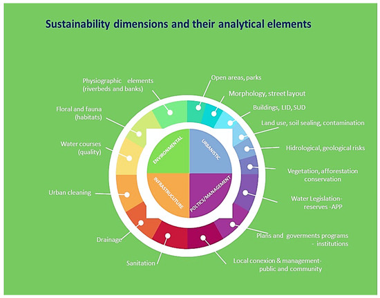
Scheme 1.
The dimensions of sustainability. Source: [39]. Adapted by the authors.
4. Results and Discussions
The history of São Paulo’s rivers is marked by challenges arising from intense urbanization. Initially, these rivers were essential elements of the local ecosystem, crucial for both the original indigenous communities and the early settlers. However, the rapid growth of the metropolis, especially from the late 19th to the 20th century, negatively impacted these watercourses.
The rivers of São Paulo, characterized as “plain rivers”, have extensive flat areas prone to flooding, including their floodplains. The straightening and channelization of these rivers facilitated the occupation of previously flood-prone areas, transforming them into urbanized zones with a variety of uses. These interventions, although they altered the natural flow of the rivers, intensified the effects of floods, increasing their frequency and strength.
One of the chronic problems is pollution. With urban expansion and the lack of appropriate infrastructure for sewage treatment and waste management, the rivers became receptors of pollutants. The situation worsened with industrialization, which added chemical effluents and other industrial waste to the waters, further compromising their quality.
Straightening and channelization, strategies adopted to facilitate water drainage and prevent urban floods, resulted in the reduction of biodiversity and alteration of river ecosystems, in addition to reducing the rivers’ capacity to absorb flow variations. Urban expansion also led to soil sealing, exacerbating the risks of flooding—a problem that such interventions initially sought to mitigate.
The irregular occupation of riverbanks, especially in flood-prone areas, represents another significant challenge. The lack of regulation and oversight allowed the establishment of communities in risk zones, where floods are common and access to basic services, such as sanitation, is limited, further contributing to river pollution.
The Jaguaré stream watershed exemplifies these problems and allows us to rethink sustainable processes for its occupation.
4.1. The Jaguaré Stream River Basin in São Paulo and Proposals for Reducing Floods
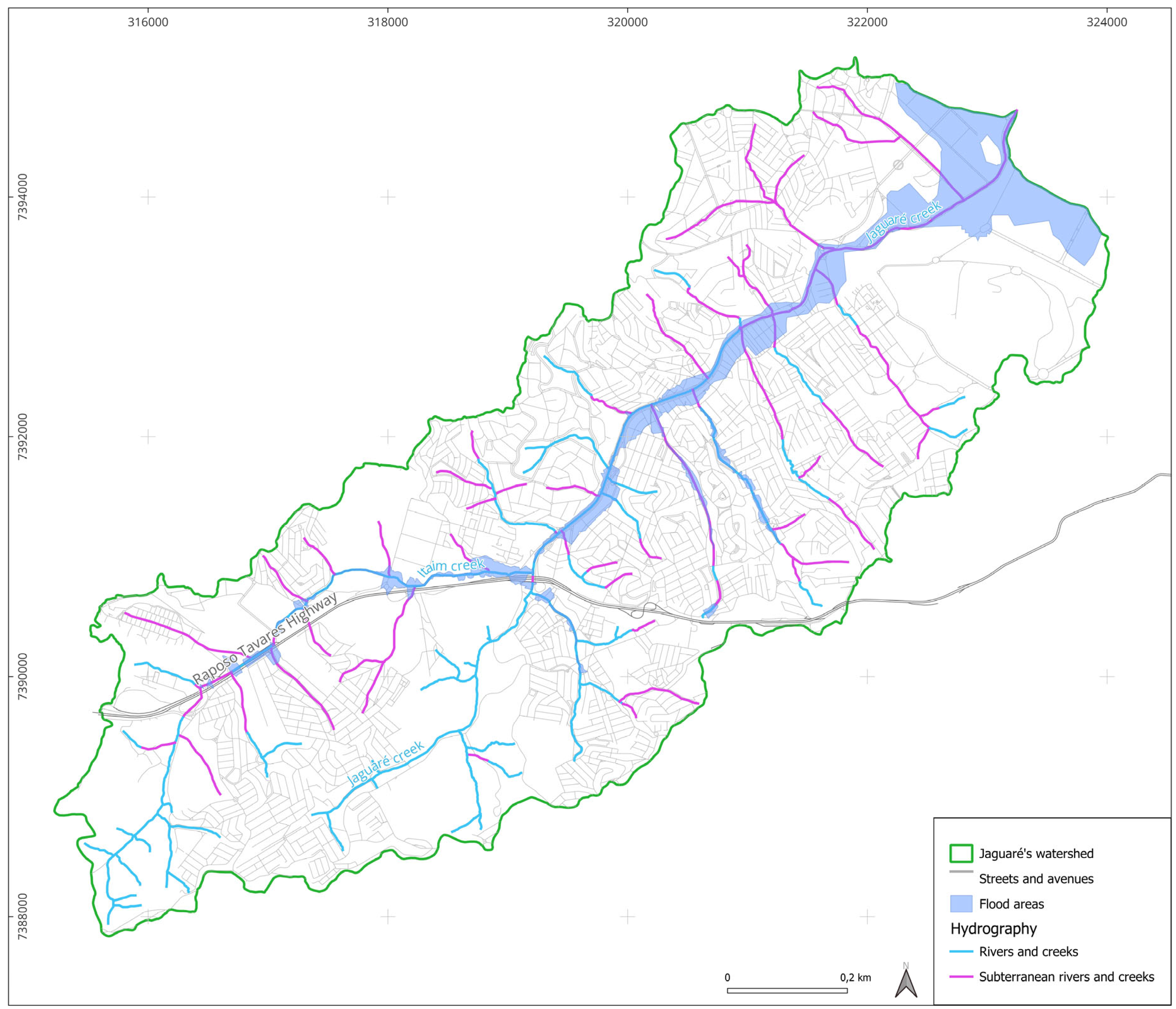
The Jaguaré stream watershed is in the western zone of the municipality of São Paulo, covering an area of 28.2 km2, corresponding to 1.9% of the municipality’s total area [42]. This region of São Paulo, called the southwestern vector, has transitioned from historically intensive industrial and residential use to a significant global financial hub. It boasts high employability and high land value, making it a subject of disputes in the context of a metropolis marked by great socio-spatial inequalities [1,45].
The study of the Jaguaré stream hydrographic basin is justified because (i) it is completely situated within the limits of the city of São Paulo; (ii) its diversity of occupation has allowed for studies on different urbanization scenarios with conservation areas in the headwaters and natural beds protected by vegetation in the main contributors; with low- and medium-density neighborhoods made up of single-family and multi-family homes in the middle portion of the basin, which coexist with preserved natural beds and sections occupied by precarious settlements; with industrial occupation, which has been changing due to the construction of vertical residential condominiums and the presence of institutions, such as the University of São Paulo (USP) and the Institute of Technological Research (IPT), in its lower region next to the river mouth; and (iii) the basin has been the subject of interventions in order to protect and restore environmental quality with the implementation of some stretches of linear parks and environmental sanitation government programs (Córrego Limpo) [Clean Stream] promoted by the Water Supply and Sanitation Services Company (Sabesp) and by state and municipal governments.
The main hydrography consists of the Jaguaré and Itaim streams, along with important tributaries. The length of the main axis is 11.8 km, and the total length of watercourses in the Jaguaré stream basin is approximately 90 km. As for its geological units, it is characterized as an alluvial plain with valley-bottom areas with low slope (less than 5%), sandy and clayey soils of varying thickness, and shallow water levels, which are areas prone to flooding. With a population of approximately 250,000 inhabitants and an average population density of 37.24 in/ha, its land use and occupation characteristics include a predominance of horizontal and vertical residential use, commerce and services, and incipient industry. There is a significant percentage of preserved green areas, mainly upstream but also associated with road and infrastructure systems. There are favelas located in high-risk and environmentally fragile areas (Table 1).

Table 1.
Uses observed in the Jaguaré stream basin with their respective areas and percentage in relation to the total area of the basin. Source: [42]. Adapted by the authors.
The Jaguaré stream basin has areas prone to flooding (see Figure 1 Map of flood-prone areas in the Jaguaré stream basin) with critical areas located upstream at the confluence of the Itaim stream bed with the Raposo Tavares highway, resulting from a section restriction in the crossing of this infrastructure. In the Jaguaré stream, critical flood-prone areas occur in the headwater region and at the confluence with a tributary (Jacarezinho stream). At these two points, there is also a section restriction due to the crossing of the road system, which highlights conflicts arising from the implementation of mobility infrastructure systems in relation to the hydrological dynamics of the basin. Additionally, there are flood-prone areas in the low-lying region adjacent to the estuary, influenced by the backwater of the Pinheiros river, to which the Jaguaré stream contributes.
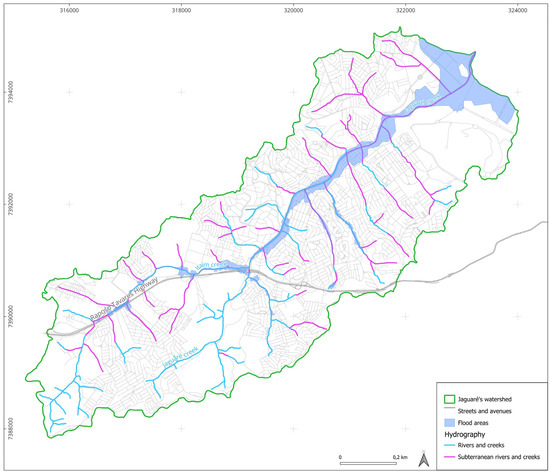
Figure 1.
Map of flood-prone areas in the Jaguaré stream basin. Source: Compiled by the authors.
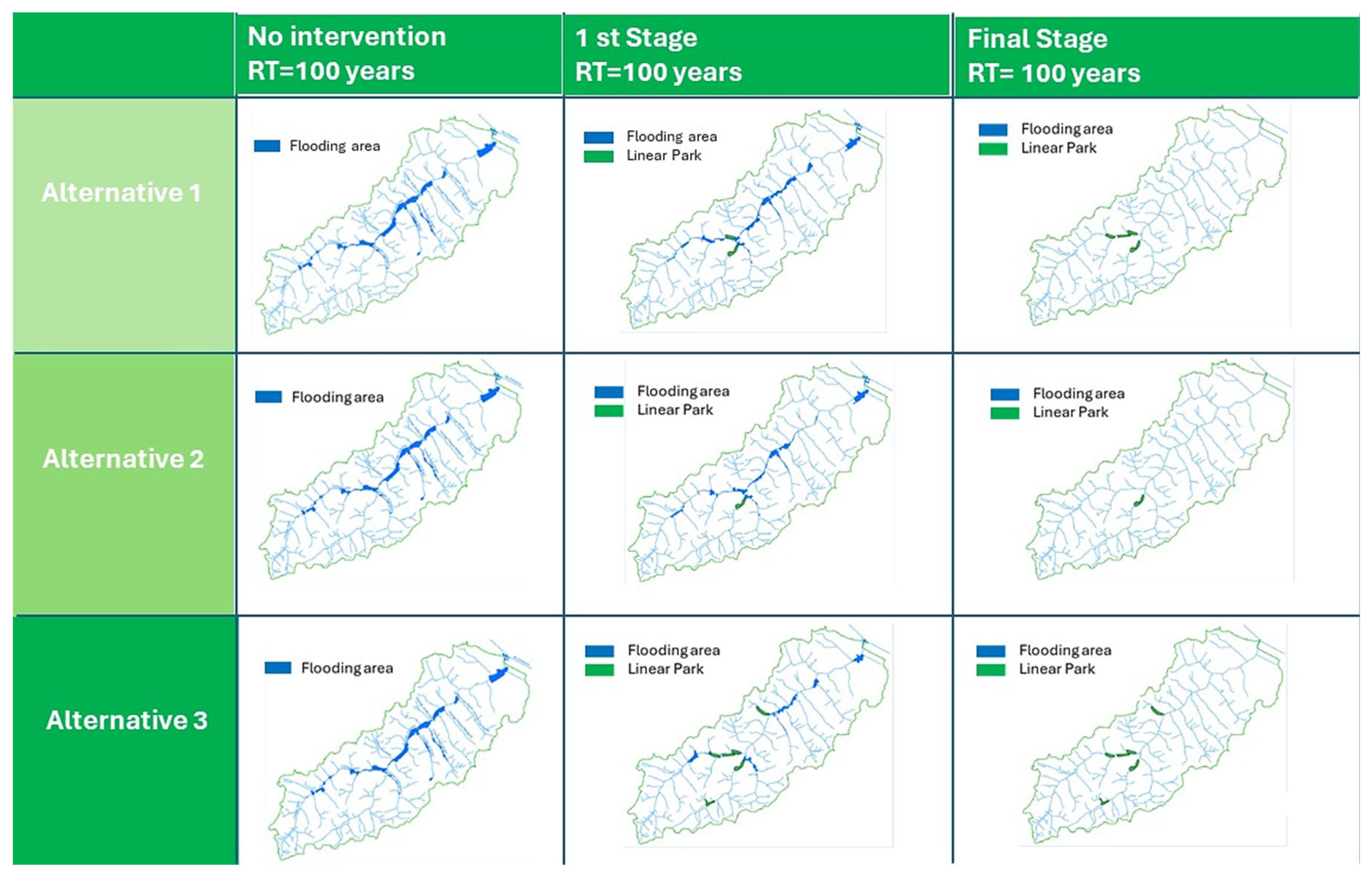
For flood-prone areas, the Jaguaré Project presented measures aimed at controlling surface runoff and reducing flooding to the level of hydrological risk for 100-year return (RT = 100) period rains. Mixed structural solutions were adopted, including gray infrastructures (strengthening of drainage systems, construction of reservoirs, and channelization of streams) and green-blue infrastructures (linear parks), and hydraulic modeling was carried out with three alternatives to be implemented in three stages (current situation, stage 1, and stage 2).
Alternative 1 included two storage reservoirs, four linear parks, stream channelization, drainage system reinforcement, elevation of two bridges, and a forced drainage system. Alternative 2 included four storage reservoirs, one linear park, stream channelization, and drainage-system reinforcement. Alternative 3 included two storage reservoirs, six linear parks, stream channelization, drainage-system reinforcement, elevation of two bridges, and a forced drainage system. Table 2 below, generated from a mathematical model of the studied alternatives, shows the respective flood areas and the number of affected lots for each stage. Cartographies were also produced to represent the calculation of flood areas resulting from rainfall, as they are an efficient method of visualizing the effect of proposed control measures (Figure 2).
Table 2.
Effects of alternatives 1, 2, and 3 in the Jaguaré stream basin. Source: [42]. Adapted by the authors.

Figure 2.
Flood areas in the Jaguaré stream basin in the 3 described alternatives. Source: [42]. Adapted by the authors.
4.2. General Principles and Recommendations for Redevelopment and Adaptation in Urbanized Botton Valley
The studies presented by the Jaguaré Project aimed to provide support for future discussions within the municipality of São Paulo regarding solutions to address hydrological risk situations and watershed management, especially to subsidize the basin notebooks that comprise the Drainage Master Plan of the municipality of São Paulo. We opted for a qualitative interpretation instead of measurements. By adopting new paradigms for proposing mixed infrastructure solutions, the Jaguaré Project demonstrated the technical feasibility of adopting adaptive infrastructure solutions.
For the research presented in this article, the studies supported investigations and propositions by providing data that sought to expand analyses at the watershed scale beyond the issue of risk reduction. This systemic approach incorporated other dimensions of sustainability, integrating them into land-use management, aiming to propose guidelines and recommendations of a socio-environmental nature that comprehensively cover the territory of the watershed [46,47].
Areas subject to floods were analyzed based on hydrological and socio-environmental studies on the Jaguaré basin and considering urbanistic and infrastructure aspects. The goal was to propose solutions to make urban structures and buildings safer, adjusting them to environmental features, and evaluating the need for adjustment to existing legal standards and urban plans.
From the analysis of the Jaguaré Project, additional data from the basin were analyzed through surveys and on-site visits from aerial photos, allowed for a necessary systemic approach to evaluate the multiple dimensions and relationships in the region of the Jaguaré stream basin. This enabled the extraction of principles and recommendations that can be generalized to other basins.
The principles were selected to compose analytical tables by topics and organize the recording of the communications in a direct manner, identifying key issues to be pondered and evaluated.
The recommendations were organized according to the four dimensions of sustainability (urbanistic, environmental, political-administrative, and infrastructure), which structured the final stage of the research.
Such recommendations cover structural and non-structural measures, i.e., the environmental approach, considering occupation patterns that are compatible with the environmental features of the valley-bottom areas; participatory management processes; and recasting programs, plans, and specific standards to reduce flood impact and risks in these areas. These recommendations encourage a systemic involving several scales and promote a collaboration between local authorities (state companies and regional municipal governments), local communities, and private owners to implement interventions in public spaces and adjustments in private properties, with public technical and financial support.
Table 3.
General principles for redevelopment and adaptation in urbanized valley-bottom areas. Source: [39]. Adapted by the authors.
Table 4.
Regeneration and adjustment recommendations for urbanized valley-bottom areas. Source: [39]. Adapted by the authors.
The general principles outlined in Table 3 aim to guide the creation of urban planning for areas located in valley bottoms, emphasizing the integration of green and blue infrastructure as an essential part of a systemic approach in urban environmental planning and management. This methodology proposes merging drainage and stormwater management strategies based on both structural and non-structural solutions, including the use of parks, rain gardens, restored wetlands, and green and blue corridors to enhance water and waste management, as well as to restore the natural water cycles and promote biodiversity. Furthermore, it emphasizes the importance of active participation from all stakeholders in the land-use and occupation process, including public authorities, public service and infrastructure companies, community members and residents, as well as the general population, aiming to create more resilient, sustainable, and harmonious urban environments with environmental dynamics.
Based on the general principles, the recommendations systematized in Table 4 can be replicated provided that the specifics and modes of operation of each basin are considered. It is emphasized that all recommendations unfold into actions that consider the basin in an integrated manner, especially the relationship between land use and the implementation of adaptive infrastructures (green-blue and grey, when necessary). These suggestions highlight actions that require involvement from both the public and private sectors, respecting anthropic and natural contexts to promote harmony between urbanization and environmental dynamics. In other words, they must align with the hydrological and environmental characteristics of the basin, promoting public uses and the adaptation of structures in already urbanized areas prone to flooding in a way that does not compromise individual and collective safety.
The recommendations were organized into four integrated dimensions, as pointed out in the methodology (Section 2): political-institutional, environmental, urban planning, and infrastructural.
In the political-institutional dimension, watershed planning, and governance model, a systemic, multi-scale, and participatory model of urban planning and governance is presumed, implying the effective participation of various players—public officers, public service concessionaires, local communities, and the population in general.
For the environmental dimension, the recommendation is to implement new sustainable rainwater management systems, which have been adopted in several countries under different names (LID, SuDS, WSUD) but are all based on the same concepts and principles that emphasize nature-based solutions, acknowledging the fundamental importance of restoring and preserving the natural cycles of water and vegetation in urban environments. The need for environmental design for valley-bottom areas is reinforced.
For the urbanistic and infrastructural dimensions, the recommendations include the mapping and zoning of flood-prone areas and the implementation of mixed infrastructures, with an emphasis on blue-green, to reduce situations of risk (strictly for public officers) and adjustments in flood and drainage areas in both the public and the private realms.
Without aiming to exhaust the complexity of the topic, these recommendations contribute to reclaiming/recovering riparian spaces, fostering a connection between people and water, anticipating flood risks, reducing socio-environmental damages and losses, and promoting urban space resilience.
5. Conclusions
Urban and environmental planning must adapt to periodic flooding. This requires the development of innovative social and technical frameworks based on a shared governance model between the state and society, especially considering the effects of climate change that have been challenging for managers and have impacted life in cities across the world.
In the context of extreme climate events, it is pressing to reconsider the urbanization models and infrastructure solutions adopted in Brazilian cities and to point to sustainable paths that can promote a closer relationship between urban rivers and the population.
The analyses of the Jaguaré stream basin in São Paulo have contributed to the creation of a set of general planning principles and recommendations that can be replicated in valley -bottom areas, aiming to promote the regeneration of river landscapes, improve the quality of the water, and establish sustainable balances between society and the environment.
This study aimed to contribute to urban studies that link infrastructure, urbanization, and the environment, especially in terms of overcoming entrenched conceptual and functionalist paradigms. It also highlighted the need to adopt systemic and multi-scale approaches to integrate socio-environmental complexities. In this sense, a revision of the territorial management and governance approach is essential so that local cultures can be valued through participatory processes. Valley-bottom regions with floodable areas, like the Jaguaré stream case study, play a vital role in hydrological regimes, in climate balance, and in the quality of urban life when adaptive infrastructure is incorporated, especially integrating non-structural measures, particularly green-blue systems. The idea is to value the biomes and watercourses that have a significant role in absorbing the impacts of basin waterproofing, in filtering and infiltrating rainwater, and in restoring balance in the hydrological regime, in addition to privileging the public use of green spaces.
In a metropolis as large and complex as São Paulo, strengthening local management can offer clarifications for implementing more viable, more economical, and more efficient infrastructure and land-use solutions. This approach contrasts with large-scale construction works that require heavy public investment and are subject to political pressures and influences, which are often external and unrelated to the interests of local groups.
Promoting sustainable and integrated management of urban waters, drainage, and the built environment in Brazilian cities may seem, at first glance, like a utopian proposition. However, it entails a shift in the dominant paradigm in urbanization and signals that the revitalization of urbanized valley-bottom areas is a crucial step towards social sustainability.
It is recognized that there is a long way to go in improving measures aimed at establishing environmental justice situations in the valley-bottom regions in Brazilian cities. This path is marked by significant challenges and limitations. The effective implementation of these measures is conditioned by the political-administrative sphere, placing our research within the academic realm, replicable through experiments, modeling, and mathematical calculations, and subject to theoretical-experimental analyses.
For their effective incorporation into the territory, these measures depend not only on the implementation of land-use laws and regulations but also on a change in society’s mindset. Additionally, it is crucial to establish a continuous monitoring process to ensure the adaptation and adjustment of strategies as new information and contexts emerge.
Finally, we want to reiterate our conviction that the regeneration of valley-bottom areas is vital for the future and quality of life in cities, representing one of the most important strategies to address extreme events resulting from climate change.
Supplementary Materials
The following supporting information can be downloaded at: https://www.mdpi.com/article/10.3390/su16073018/s1, File S1: General principles for the requalification and adaptation of occupations in urbanized valley bottom areas.
Author Contributions
Conceptualization, A.C.V.d.C.; Methodology, A.C.V.d.C. and A.T.B.A.; Investigation, A.C.V.d.C.; Writing—original draft, A.C.V.d.C. and A.T.B.A.; Writing—review & editing, A.T.B.A.; Funding acquisition, A.T.B.A. All authors have read and agreed to the published version of the manuscript.
Funding
This study is part of project research “INFRASTRUCTURE NETWORKS OF BRAZILIAN CITIES IN THE CONTEXT OF CLIMATE CHANGE: VULNERABLE AREAS AND RESILIENCE” (nº 221074, MACK—0008793) financed by the “Fundo Mackenzie de Pesquisa e Inovação” (MackPesquisa) and “Conselho Nacional de Pesquisa e Tecnologia” (CNPq, Universal Edital). It’s also part of the thesis “Parameters for the Sustainable Occupation of Valley Bottom Areas in Urban Environments: The Case of the Jaguaré Stream Watershed, São Paulo” founded by the Mackenzie Presbyterian Institute and Academic Excellence Program of “Coordenação de Aperfeiçoamento de Pessoal de Nível Superior-Brasil” (CAPES).
Institutional Review Board Statement
Not applicable.
Informed Consent Statement
Not applicable.
Data Availability Statement
Data are contained within the Supplementary Materials.
Acknowledgments
The authors are grateful to Mackenzie Presbyterian University, MackPesquisa, CAPES PROEX and CNPq for making this work possible.
Conflicts of Interest
The authors declare no conflicts of interest.
References
- Iglecias, W. Impactos da Mundialização Sobre Uma Metrópole Periférica: O Vetor Sudoeste de São Paulo. Cad. Metrópole 2001, 6, 9–41. Available online: https://revistas.pucsp.br/index.php/metropole/article/view/9267 (accessed on 12 October 2023).
- IPCC. The Intergovernmental Panel on Climate Change—Climate Changes 2023. Available online: https://www.ipcc.ch/report/ar6/syr/downloads/report/IPCC_AR6_SYR_SPM.pdf (accessed on 1 February 2024).
- Nobre, C.; Young, A. (Eds.) Vulnerabilidades das Megacidades Brasileiras às Mudanças Climáticas: Região Metropolitana de São Paulo; Instituto Nacional de Pesquisas Espaciais e universidade Estadual de Campinas: Campinas, SP, Brazil, 2011; Available online: https://www.nepo.unicamp.br/publicacao/vulnerabilidades-das-megacidades-brasileiras-as-mudancas-climaticas-rmsp/ (accessed on 12 October 2023).
- Dodman, D. Cities, settlements and key infrastructure. In Climate Change in Impacts, Adaptation, and Vulnerability; Cambridge University Press: Cambridge, UK, 2022; Volume 1, Available online: https://ink.library.smu.edu.sg/cis_research/33/ (accessed on 1 March 2023).
- Marengo, J.A.; Camarinha, P.I.; Alves, L.M.; Diniz, F.; Betts, R.A. Extreme Rainfall and Hydro-Geo-Meteorological Disaster Risk in 1.5, 2.0, and 4.0 °C Global Warming Scenarios: An Analysis for Brazil. Front. Clim. 2021, 3, 610433. [Google Scholar] [CrossRef]
- Alencar, J.C. Bacias Hidrográficas Urbanizadas: Renaturalização, Revitalização e Recuperação. Um estudo da Bacia do Jaguaré. Ph.D. Thesis, Escola Politécnica da Universidade de São Paulo, São Paulo, Brazil, 2017. [Google Scholar]
- Travassos, L.R.F.C. Revelando os Rios: Novos Paradigmas Para Intervenção em Fundos de Vale Urbanos Na Cidade De São Paulo. Ph.D. Dissertation, Faculdade de Arquitetura e Urbanismo da Universidade de São Paulo, São Paulo, SP, Brasil, 2010. [Google Scholar]
- Tucci, C.E.M. Urban Waters. Estud. Avançados 2008, 22, 63. Available online: https://www.scielo.br/j/ea/a/SfqYWrhrtvkxybFsjYQtx7v/?format=pdf&lang=en (accessed on 27 December 2023).
- Anelli, R. Redes de Mobilidade e Urbanismo em São Paulo. Das Radiais/Perimetrais do Plano de Avenidas à Malha Direcional PUB. Arquitextos, São Paulo, Ano 07, n. 082.00, Vitruvius, March 2007. Available online: https://vitruvius.com.br/revistas/read/arquitextos/07.082/259 (accessed on 1 March 2023).
- New York Cit. Zoning for Coastal Flood Resiliency. 2019. Available online: https://www1.nyc.gov/assets/planning/download/pdf/plans-studies/flood-resiliency-update/zoning-for-flood-resiliency.pdf (accessed on 12 October 2023).
- Tucci, C. Gestão Da Drenagem Urbana. Brasília, DF: CEPAL. Escritório No Brasil/IPEA, 2012. (Textos Para Discussão CEPAL-IPEA, 48). Available online: http://www.cepal.org/brasil (accessed on 27 December 2023).
- Woods Ballard, B.; Wilson, S.; Udale-Clarke, H.; Illman, S.; Scott, T.; Ashley, R.; Kellagher, R. The SuDS Manual; CIRIA: London, UK, 2015. [Google Scholar]
- Canholi. Aluísio Pardo Drenagem Urbana e Controle de Enchentes/Aluísio Pardo Canholi, 2nd ed.; Oficina de Textos: São Paulo, Brazil, 2014. [Google Scholar]
- Bai, X.; Surveyer, A.; Elmqvist, T.; Gatzweiler, F.W.; Güneralp, B.; Parnell, S.; Prieur-Richard, A.-H.; Shrivastava, P.; Siri, J.G.; Stafford-Smith, M.; et al. Defining and advancing a systems approach for sustainable cities. Curr. Opin. Environ. Sustain. 2016, 23, 69–78. [Google Scholar] [CrossRef]
- McPhearson, T.; Pickett, S.T.A.; Grimm, N.B.; Niemelä, J.; Alberti, M.; Elmqvist, T.; Weber, C.; Haase, D.; Breuste, J.; Qureshi, S. Advancing Urban Ecology toward a Science of Cities. BioScience 2016, 66, 198–212. [Google Scholar] [CrossRef]
- Alvim, A.; Abascal, E.H.S.; Brocaneli, M.P.F.; Stuermer, M.M.M. A modernidade e os conflitos socioambientais em São Paulo: Um olhar sobre o Plano Diretor Estratégico Municipal. In Encontro da Associação Nacional de Pós-Graduação E Pesquisa Em Ambiente E Sociedade (ANPPAS); Annablume: São Paulo, Brasília, 2006; Volume 3, pp. 1–17. [Google Scholar]
- Arkansas Community Design Center. Low Impact Development: A Design Manual for Urban Area; University of Arkansas Press: Fayetteville, AR, USA, 2010. [Google Scholar]
- Christofoletti, A. Modelagem de Sistemas Ambientais; Edgard Blücher: São Paulo, Brazil, 1999. [Google Scholar]
- Costanza, R.; d’Arge, R.; De Groot, R.; Farber, S.; Grasso, M.; Hannon, B.; Limburg, K.; Naeem, S.; O’Neill, R.V.; Paruelo, J.; et al. The value of ecosystem services: Putting the issues in perspective. Ecol. Econ. 1998, 25, 67–72. [Google Scholar] [CrossRef]
- Gorski, M.C.B. Rios e Cidades: Ruptura e Reconciliação; Senac: São Paulo, Brazil, 2010. [Google Scholar]
- Petts, J. Learning about learning: Lessons for public engagement and deliberation on urban river restoration. Geogr. J. 2007, 173, 300–311. [Google Scholar] [CrossRef]
- Riley, A.L. Restoring Streams in Cities: A Guide for Planners, Policy Makers, and Citizens; Island Press: Washington, DC, USA, 1998; 423p. [Google Scholar]
- Fletcher, T.D.; Shuster, W.; Hunt, W.F.; Ashley, R.; Butler, D.; Arthur, S.; Trowsdale, S.; Barraud, S.; Semadeni-Davies, A.; Bertrand-Krajewski, J.L.; et al. SUDS, LID, BMPs, WSUD and more—The evolution and application of terminology surrounding urban drainage. Urban Water J. 2015, 12, 525–542. [Google Scholar] [CrossRef]
- Mcdonald, R.I.; Depietri, Y. Green and Blue Infrastructure: Integrating Nature into Urban Environments for Climate Adaptation. Urban For. Urban Green. 2016, 18, 1–8. [Google Scholar]
- Wright, H.; Furlong, C. Integrating Nature-based Solutions in Urban Planning: A Review. Environ. Sci. Policy 2011, 58, 85–92. [Google Scholar]
- Lafortezza, R.; Chen, J.; van den Bosch, C.K.; Randrup, T.B. Nature-based solutions for resilient landscapes and cities. Environ. Res. 2018, 165, 431–441. [Google Scholar] [CrossRef] [PubMed]
- Ahern, J. Urban landscape sustainability and resilience: The promise and challenges of integrating ecology with urban planning and design. Landsc. Ecol. 2013, 28, 1203–1212. [Google Scholar] [CrossRef]
- Gill, S.E.; Handley, J.F.; Ennos, A.R.; Pauleit, S. Adapting Cities for Climate Change: The Role of the Green Infrastructure. Built Environ. 2007, 33, 115–133. [Google Scholar] [CrossRef]
- Meerow, S.; Newell, J.; Pstults, M. Defining urban resilience: A review. Landsc. Urban Plan. 2016, 147, 38–49. [Google Scholar] [CrossRef]
- Wang, C.C.; Yeh, T.Y.; Chang, C.S.; Li, M.S.; Tsuboki, K.; Liu, C.H. A modeling study of an extreme rainfall event along the northern coast of Taiwan on 2 June 2017. Atmos. Chem. Phys. 2023, 23, 501–521. Available online: https://acp.copernicus.org/articles/23/501/2023/acp-23-501-2023-discussion.html (accessed on 1 February 2024).
- Rosseto, G.; Travassos, L. Transição Para Sustentabilidade em Drenagem e Manejo de Águas Pluviais: Caminhos Teóricos Para a Pesquisa Empírica; ENANPUR: Belém, Brasil, 2023; Available online: https://anpur.org.br/wp-content/uploads/2023/10/st07-30.pdf (accessed on 27 December 2023).
- Burkhard, B. Mapping ecosystem service supply, demand and budgets. Ecol. Indic. 2012, 21, 17–29. [Google Scholar] [CrossRef]
- Cengiz, B. Urban River Landscape in Advances in Landscape Architecture; InTech: Vienna, Austria, 2013. [Google Scholar] [CrossRef]
- Demantova, G.C. Redes Técnicas Ambientais: Diversidade e Conexão Entre Pessoas e Lugares. Ph.D. Dissertation, Faculdade de Arquitetura e Urbanismo da Universidade Estadual de Campinas, Campinas, Brazil, 2009. [Google Scholar]
- Naeem, S.; Chapin Iii, F.S.; Costanza, R.; Ehrlich, P.R.; Golley, F.B.; Hooper, D.U.; Lawton, J.H.; O’Neill, R.V.; Mooney, H.A.; Sala, O.E. Biodiversity and ecosystem functioning: Maintaining natural life support processes, issues in ecology. Ecol. Soc. Am. 1999, 4, 2–12. [Google Scholar]
- Benedict, M.; McMahon, E. Green Infrastructure: Smart Conservation for the 21st Century. Renew. Resour. J. 2002, 20, 12–17. Available online: https://www.researchgate.net/publication/273127683_Green_Infrastructure_Smart_Conservation_for_the_21st_Century (accessed on 28 August 2023).
- Maranhão, D.S.D.A. Soluções Baseadas Na Natureza Na Estratégia De Clima de Uma Empresa Global de Energia Que Atua No Brasil: Um Estudo De Caso. Fundação Getúlio Vargas (FGV). 2020. Available online: https://bibliotecadigital.fgv.br/dspace/bitstream/handle/10438/29788/ta_denisemaranhao_2020oct27Final.pdf?sequence=1&isAllowed=y> (accessed on 12 October 2023).
- Alvim, A.T.B.; Kato, V.R.C.; de Godoy Rosin, J.R. Water urgency: Urban intervention in watershed areas. Cad. Metrópole 2015, 33, 83–107. [Google Scholar] [CrossRef]
- Castro, A.C.V. Parâmetros Para a Ocupação Sustentável de Areas de Fundo de Vale No Meio Urbano: O Caso da Bacia Hidrográfica do Córrego Jaguaré, São Paulo. Ph.D. Dissertation, Faculdade de Arquitetura e Urbanismo da Universidade Presbiteriana Mackenzie, São Paulo, Brazil, 2021. Available online: https://dspace.mackenzie.br/items/d3c01095-991b-44e0-ac2b-9b8abe9d5fd1 (accessed on 1 March 2023).
- Travassos, L.R.F. C Recuperação Socioambiental de Fundos de Vale Urbanos na Cidade de São Paulo, Entre Transformações e Permanências. Cad. Metrópole 2013, 15, 29. Available online: https://revistas.pucsp.br/metropole/article/view/15826 (accessed on 12 October 2023).
- Ying, J.; Zhang, X.; Zhang, Y.; Bilan, S. Green infrastructure: Systematic literature review. Econ. Res.-Ekon. Istraživanja 2022, 35, 343–366. [Google Scholar] [CrossRef]
- FCTH. Desenvolvimento de Metodologia e Projeto Piloto de Revitalização de Bacia Urbana, Replicável Para as Demais Bacias da Região Metropolitana (Bacia do Córrego Jaguaré), Empreendimento 2014 AT-653. Volumes I, II, III e IV, 2017. Available online: https://www.researchgate.net/publication/324506297_PROJETO_JAGUARE_METODOLOGIA_PARA_REQUALIFICACAO_DE_BACIAS_HIDROGRAFICAS_URBANAS (accessed on 12 October 2023).
- Felson, A.J.; Pavao-Zuckerman, M.; Carter, T.; Montalto, F.; Shuster, B.; Springer, N.; Stander, E.K.; Starry, O. Mapping the Design Process for Urban Ecology Researchers. BioScience 2013, 63, 854–865. [Google Scholar] [CrossRef]
- Farias, A. A comunicação diagramática na abordagem multidimensional da sustentabilidade urbana. In Sustentabilidade em Projetos Para Urbanização de Assentamentos Precários no Brasil: Contexto, Dimensões e Perspectivas; Alvim, A., Rubio, V., Eds.; Editora Manole: Santana do Parnaiba, Brazil, 2020. [Google Scholar]
- Pasternak, S. Loteamentos Irregulares No Município de São Paulo: Uma Avaliação Espacial Urbanística; Revista Planejamento e Políticas Públicas—PPP: São Paulo, Brazil, 2010. Available online: https://www.ipea.gov.br/ppp/index.php/PPP/issue/view/28 (accessed on 12 October 2023).
- Alvim, A.T.B.; Rubio, V.; Ledo, A. Dimensões da Sustentabilidade nos Projetos de Urbanização de Assentamentos Precários em Areas Protegidas. In Proceedings of the XII Seminario Internacional de Investigación en Urbanismo, São Paulo, Brazil, Lisboa, Portugal, 15–26 June 2020; Faculdade de Arquitectura da Universidade de Lisboa: Lisboa, Portugal, 2020. [Google Scholar] [CrossRef]
- Alvim, A.T.B.; Rubio, V.M.; Marques, A.L. Projetos de urbanização de assentamentos precários e as dimensões da sustentabilidade: Caminhos da pesquisa. In Angélica Tanus Benatti Alvim; Viviane Manzione Rubio. (Org.). Sustentabilidade em Projetos Para Urbanização de Assentamentos Precários no Brasil. Contexto, Dimensões e Perspectivas, 1st ed.; Manole: Sao Paulo, Brazil, 2022; Volume 1, pp. 202–225. [Google Scholar] [CrossRef]

Disclaimer/Publisher’s Note: The statements, opinions and data contained in all publications are solely those of the individual author(s) and contributor(s) and not of MDPI and/or the editor(s). MDPI and/or the editor(s) disclaim responsibility for any injury to people or property resulting from any ideas, methods, instructions or products referred to in the content. |
© 2024 by the authors. Licensee MDPI, Basel, Switzerland. This article is an open access article distributed under the terms and conditions of the Creative Commons Attribution (CC BY) license (https://creativecommons.org/licenses/by/4.0/).