


Chinchero as Tourism Hub and Green Corridor as a Social Integrator in Cusco Peru 2023

Abstract
1. Introduction
2. Literature Review
3. Materials and Methods
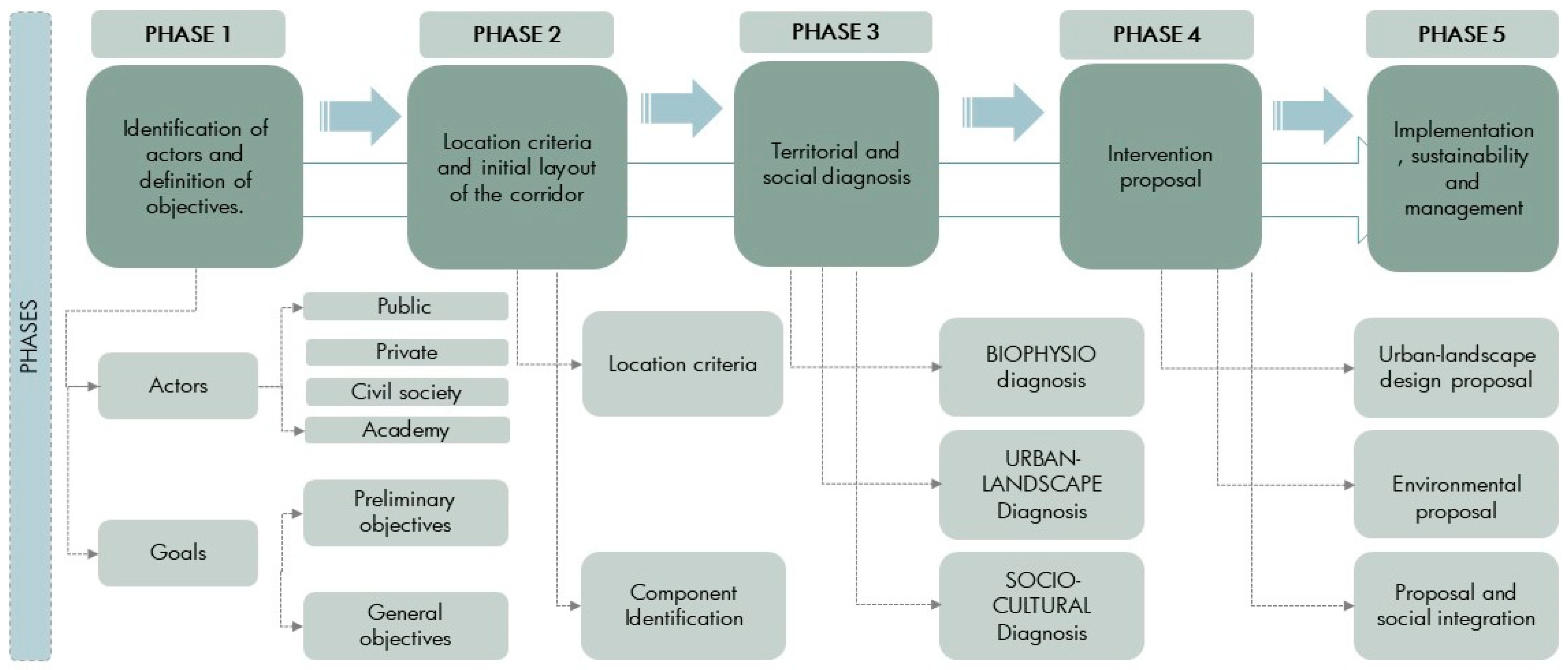
3.1. Methodology
- Identification of key stakeholders and definition of objectives.
- Establishment of criteria for the location and initial layout.
- Territorial and social diagnosis.
- Intervention proposal.
- Implementation, sustainability, and management.
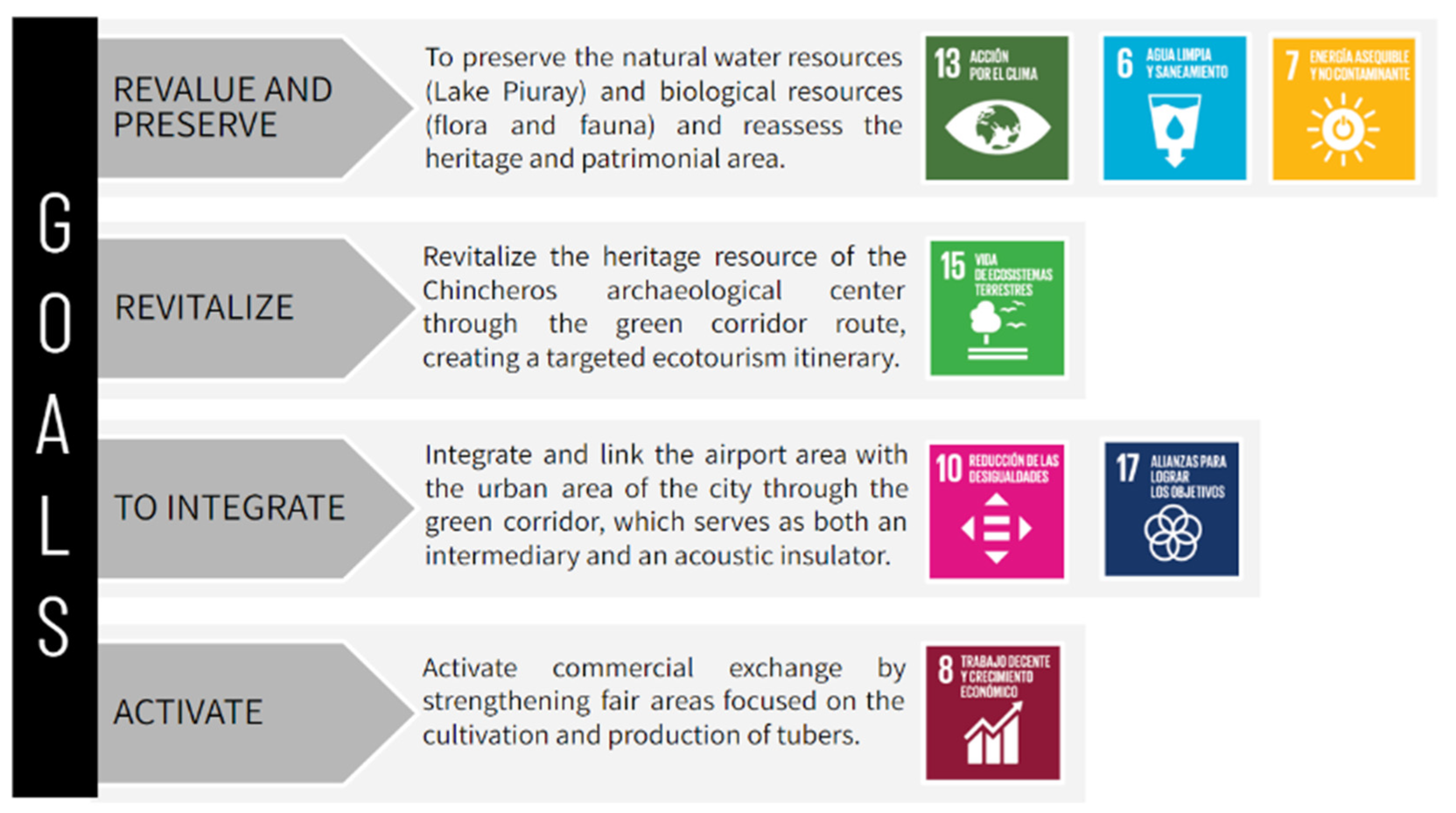
3.1.1. Identification of Key Stakeholders and Definition of Objectives
3.1.2. Establishment of Criteria for the Location and Initial Layout
- Spaces that are part of public green areas
- Spaces that allow for the integration and enhancement of natural resources
- Spaces that allow the articulation of existing urban projects and/or those planned by the government.
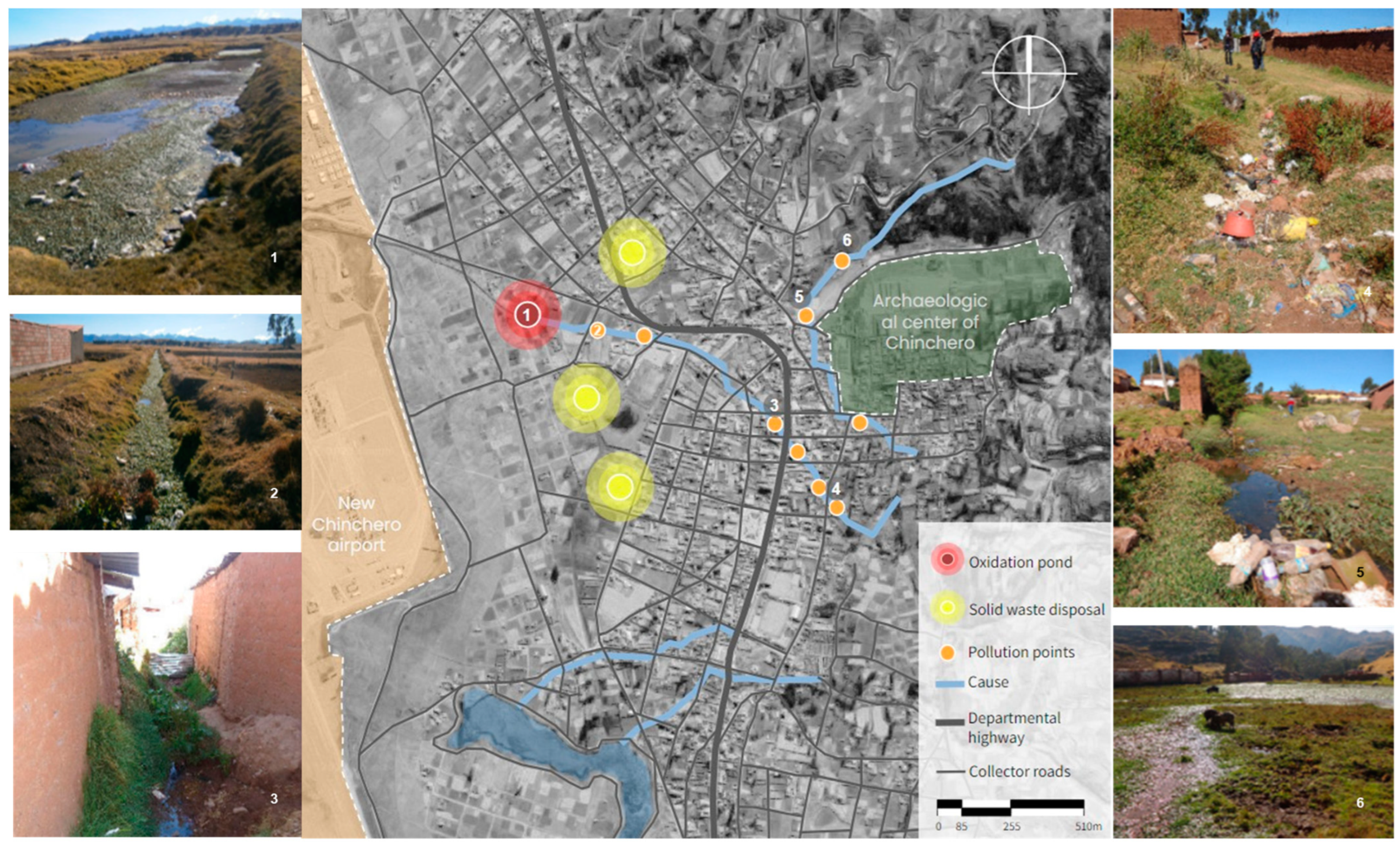
3.1.3. Territorial and Social Diagnosis
- Diagnosis of the biophysical environment
- Diagnosis of the urban and landscape environment
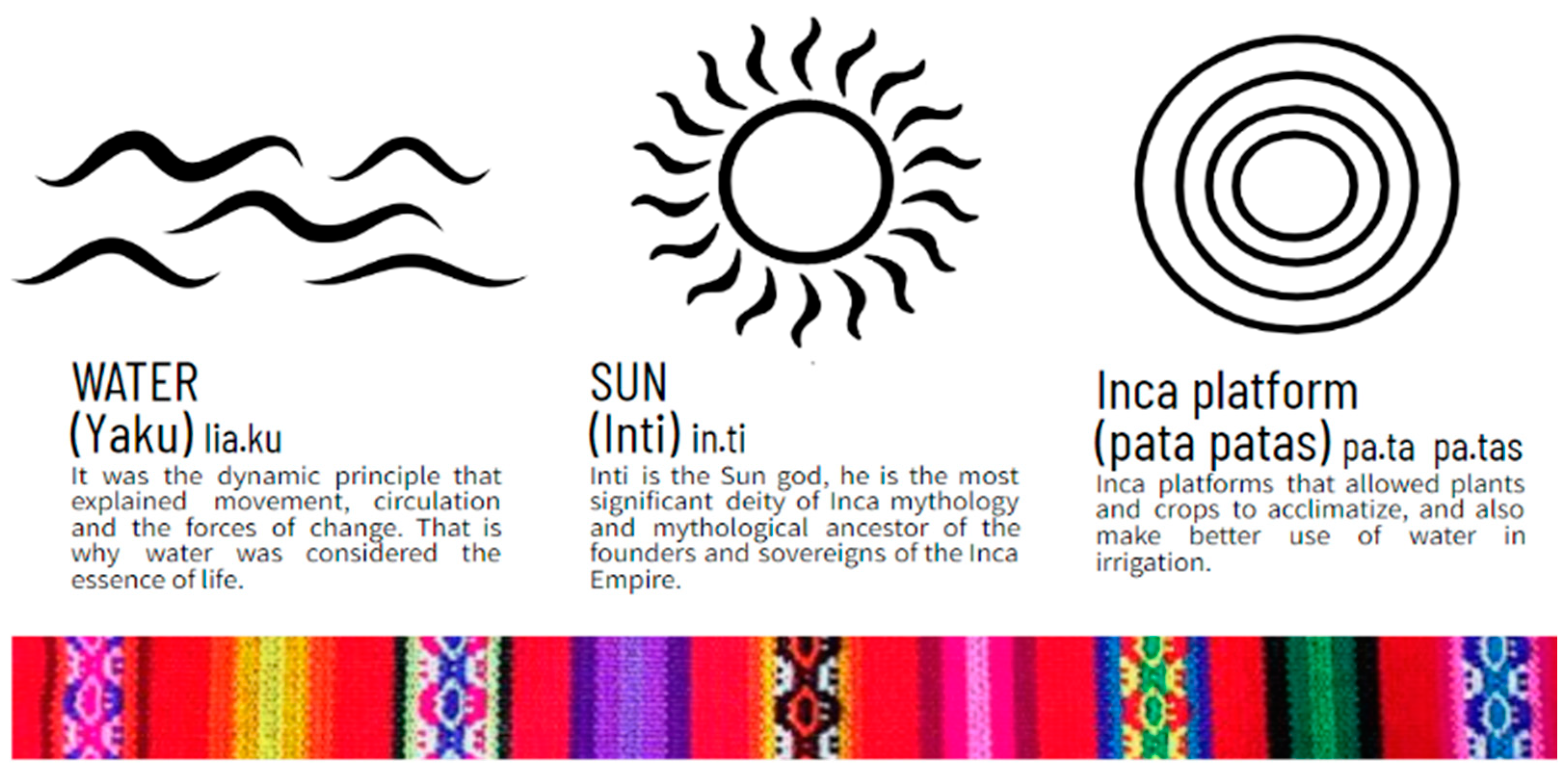
- Socio-cultural diagnosis
3.1.4. Intervention Proposal
3.1.5. Implementation, Sustainability, and Management
3.2. Actors Involved in the Design of a Green Corridor
Actors Involved in the Proposal
- Public institutions: District Municipality of Chinchero, Peruvian National Police, health center, Regional Culture Directorate, and educational institutions.
- Functional grass-roots social organizations: soup kitchens, milk banks, sports, cultural and/or folkloric associations, etc.
- Territorial social organizations: peasant communities and citizen participation.
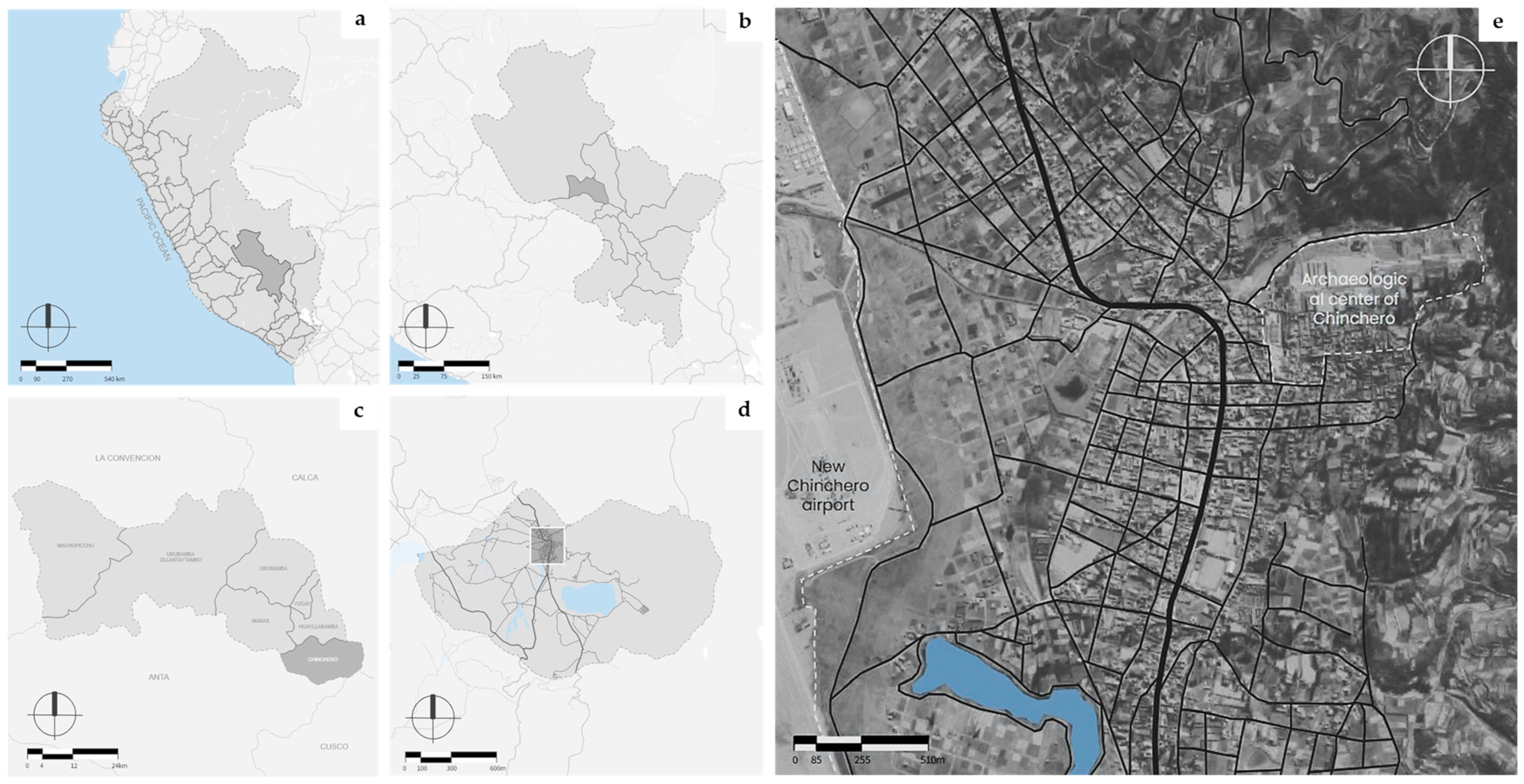
3.3. Place of Study
3.4. Diagnosis of the Territory
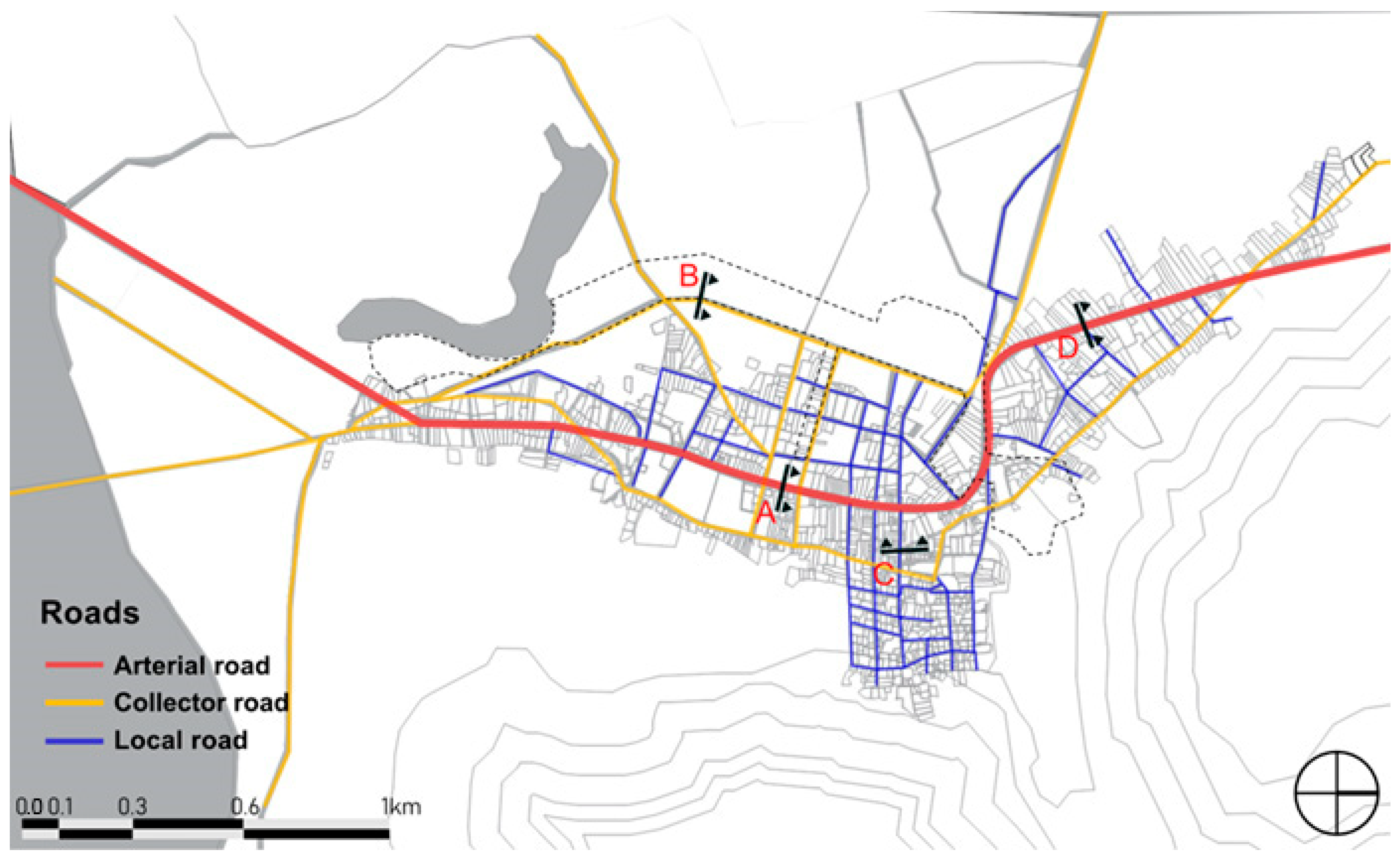
3.4.1. Urban Analysis
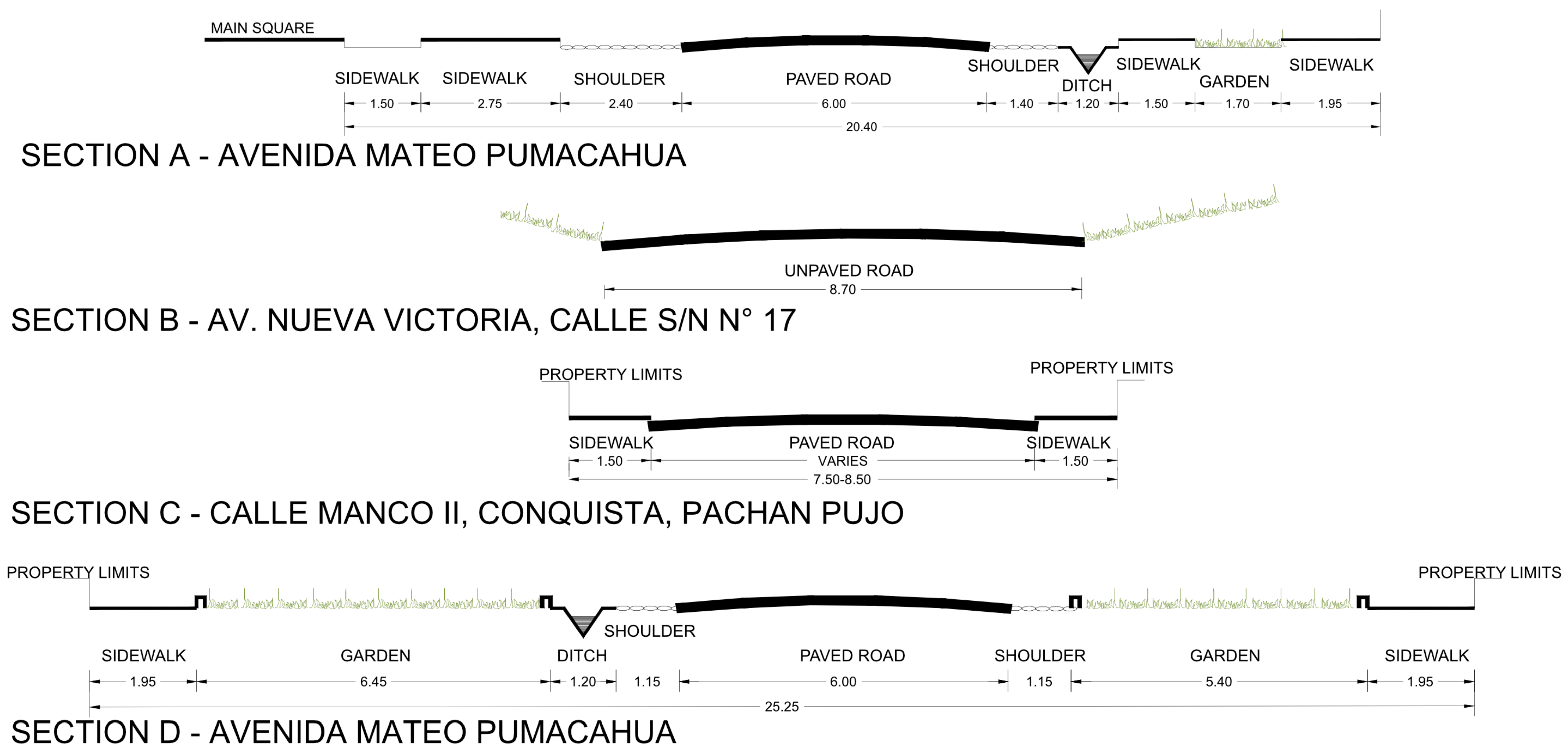
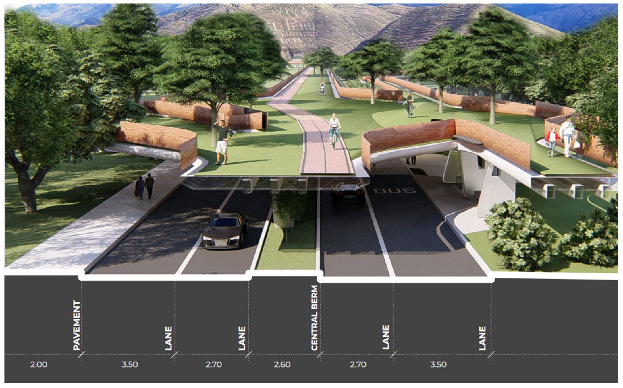
- Road analysis
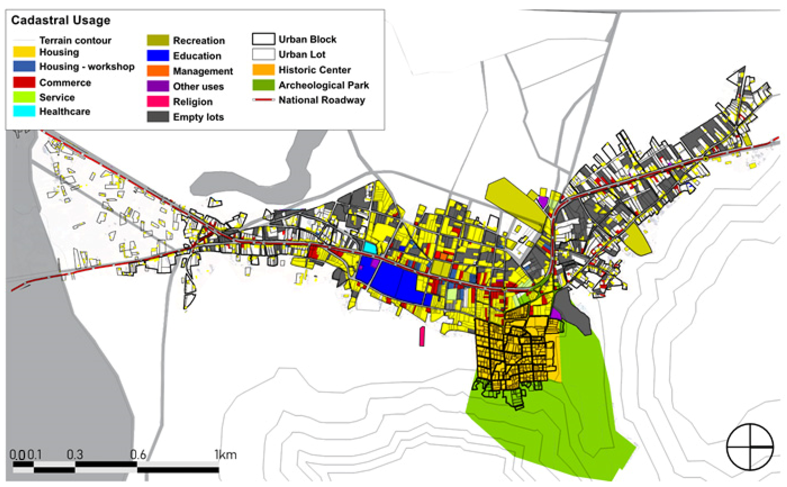
- Land use
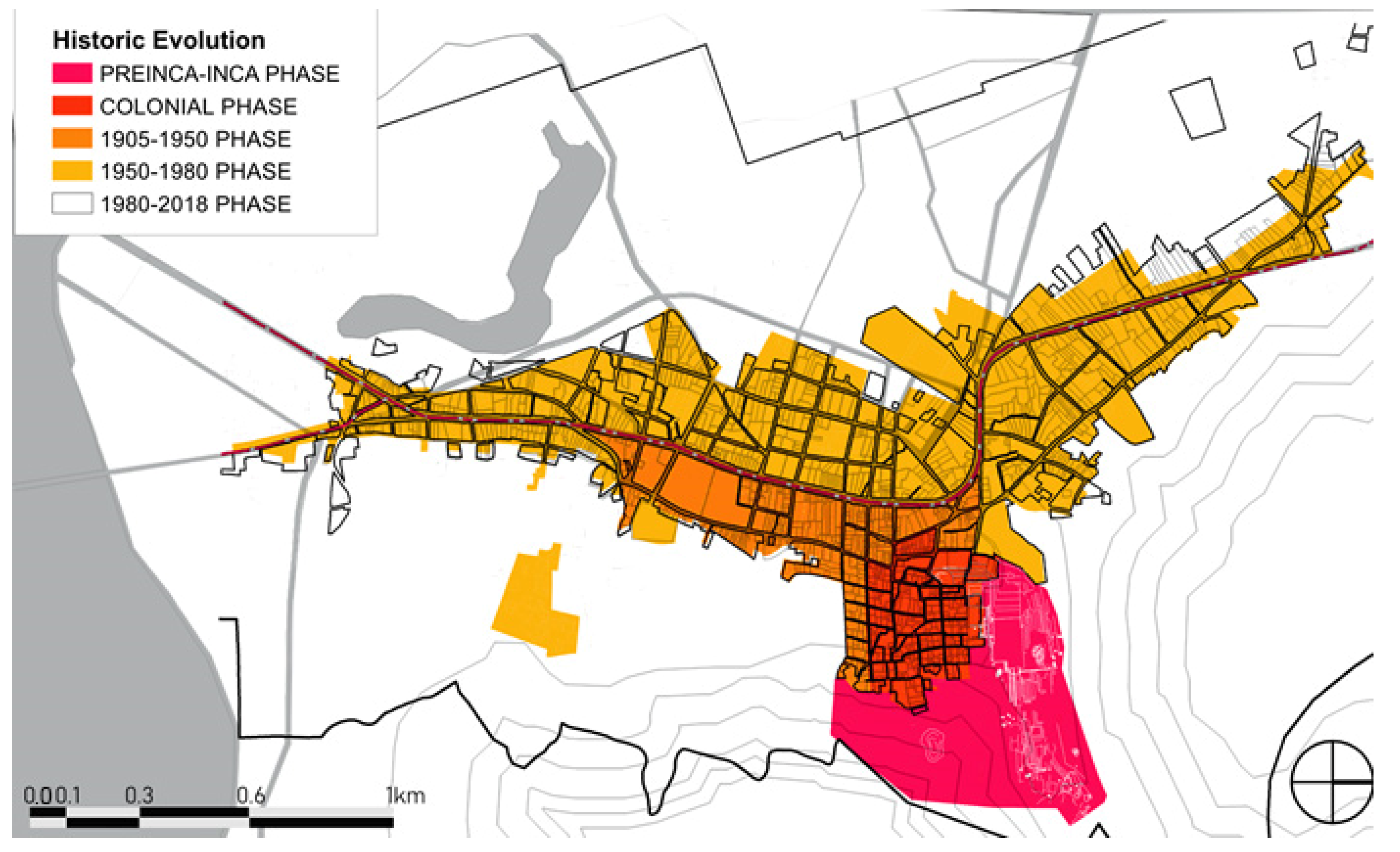
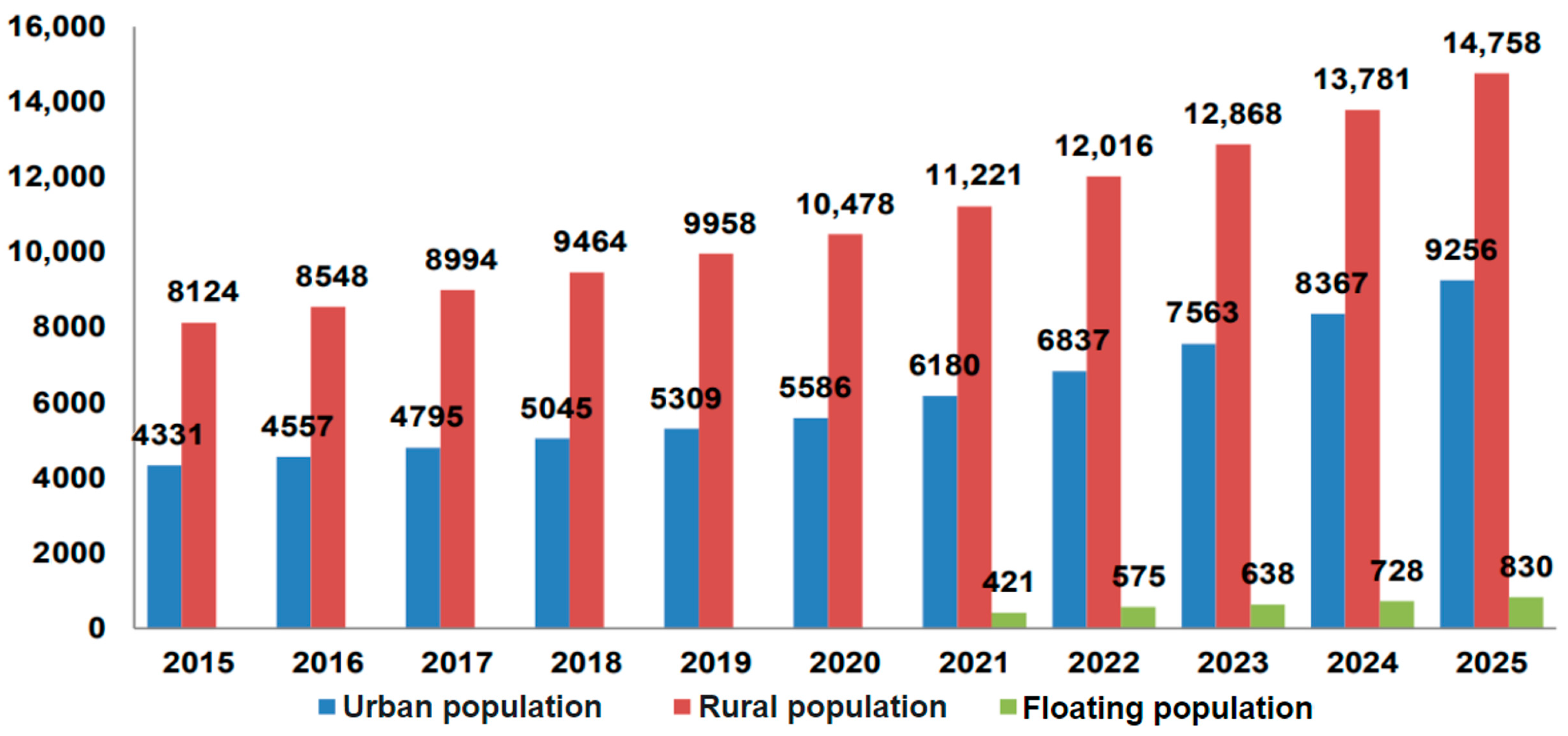
- Historic evolution and demography
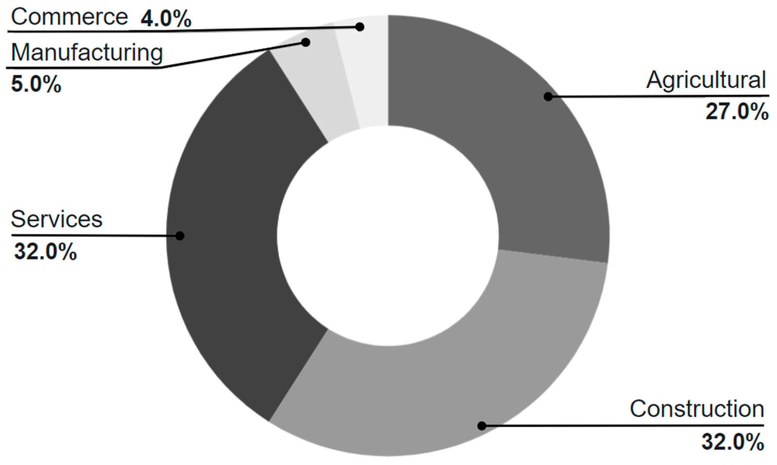
- Economic activities
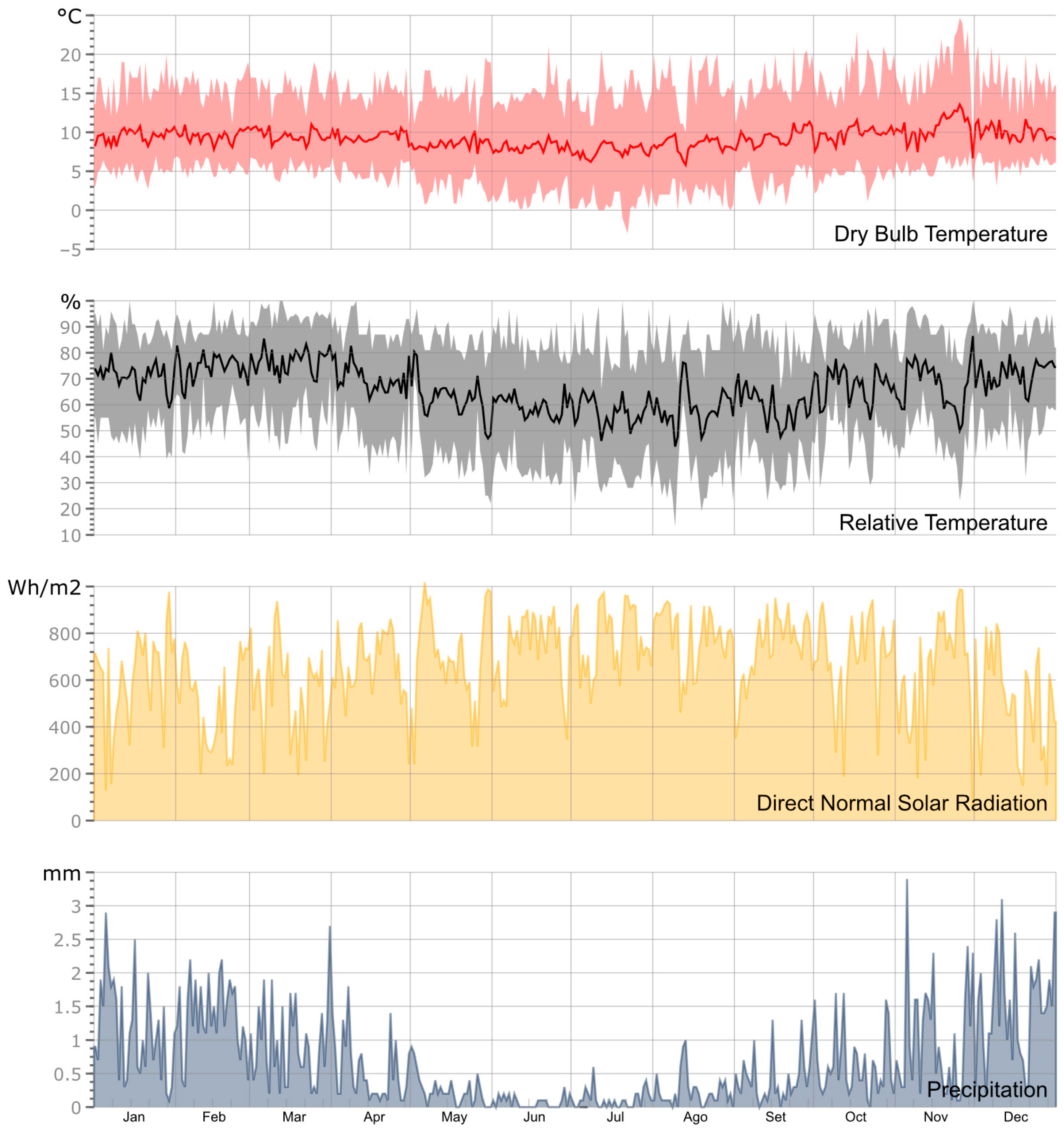
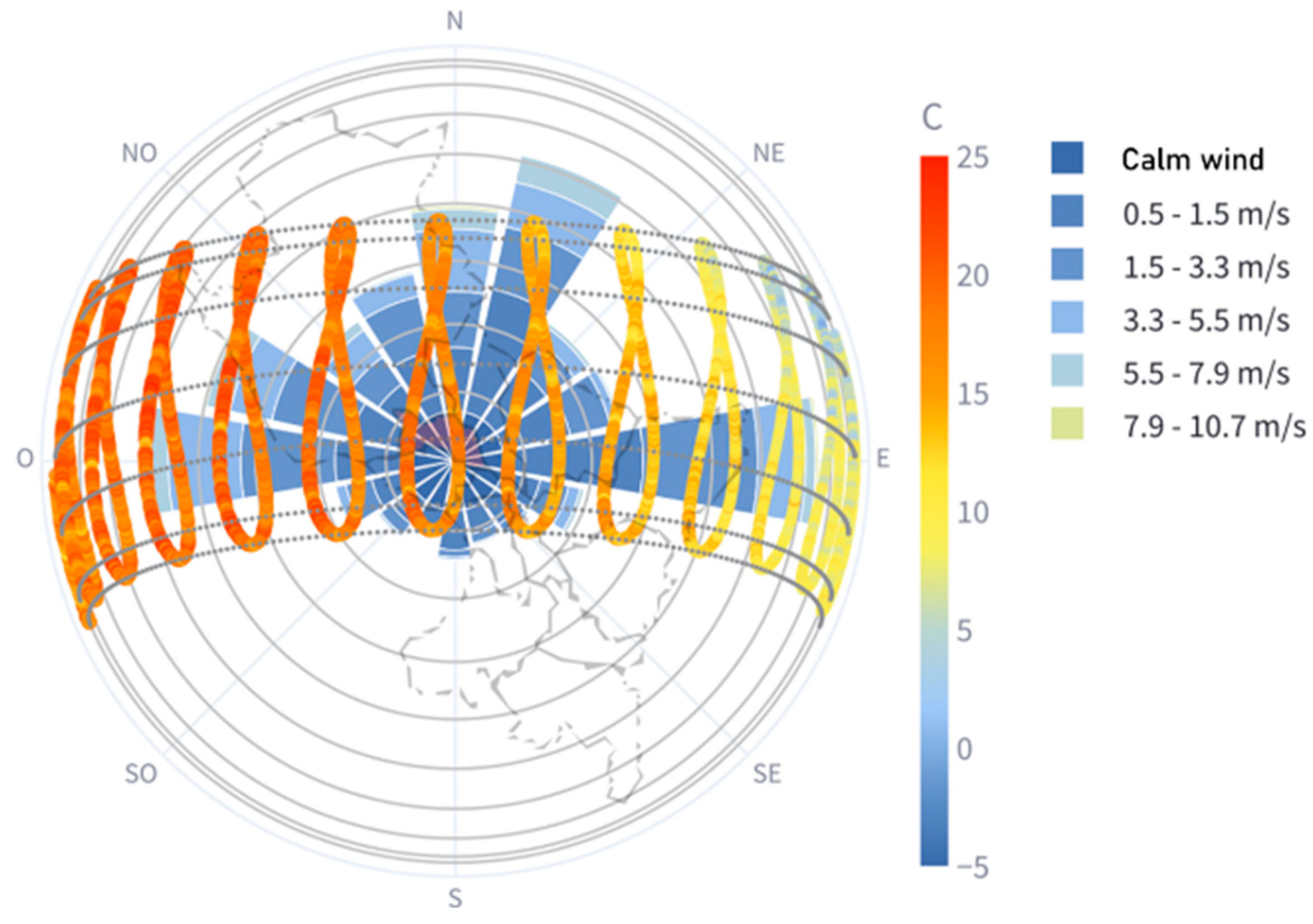
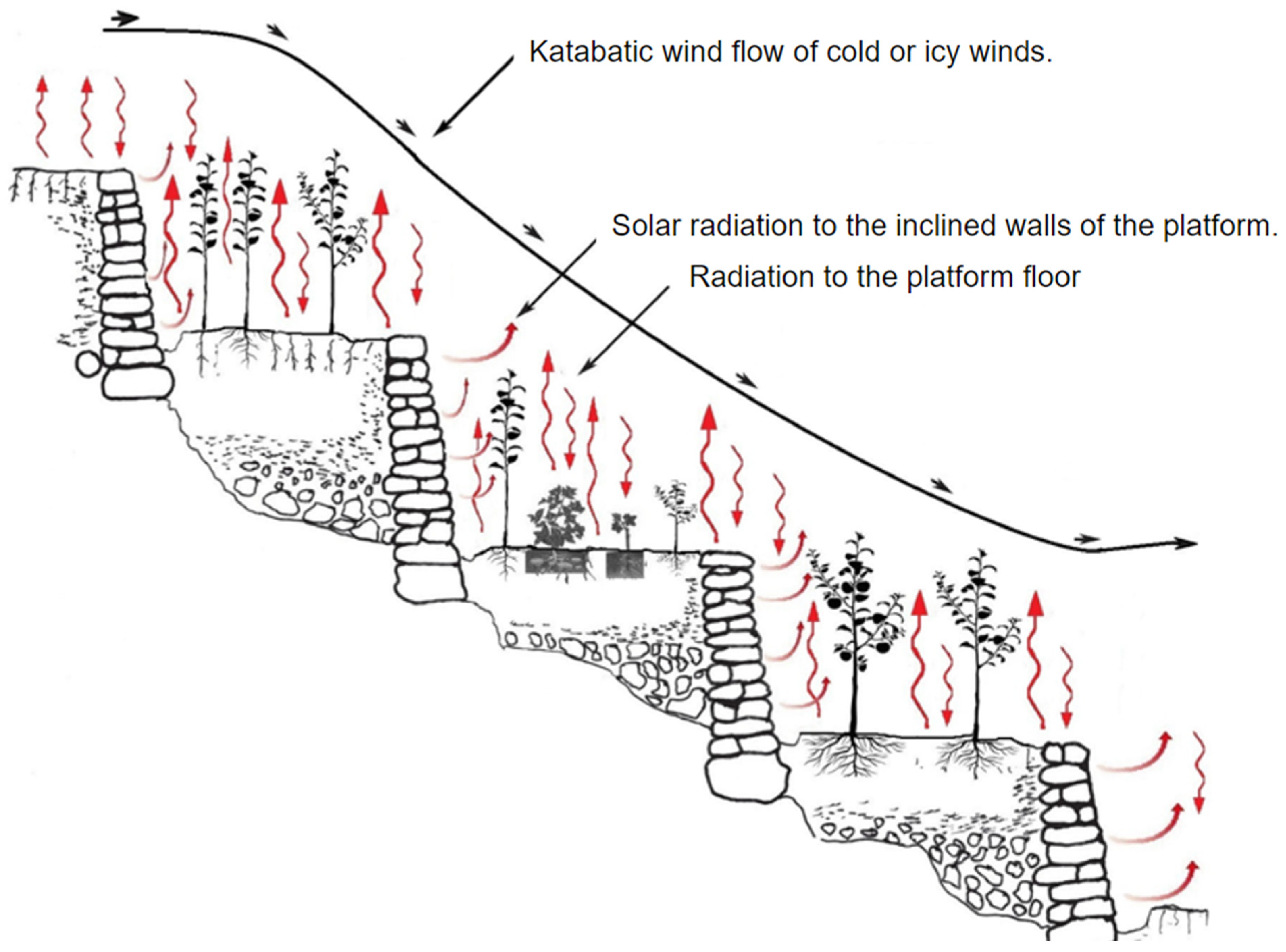
3.4.2. Climate Analysis
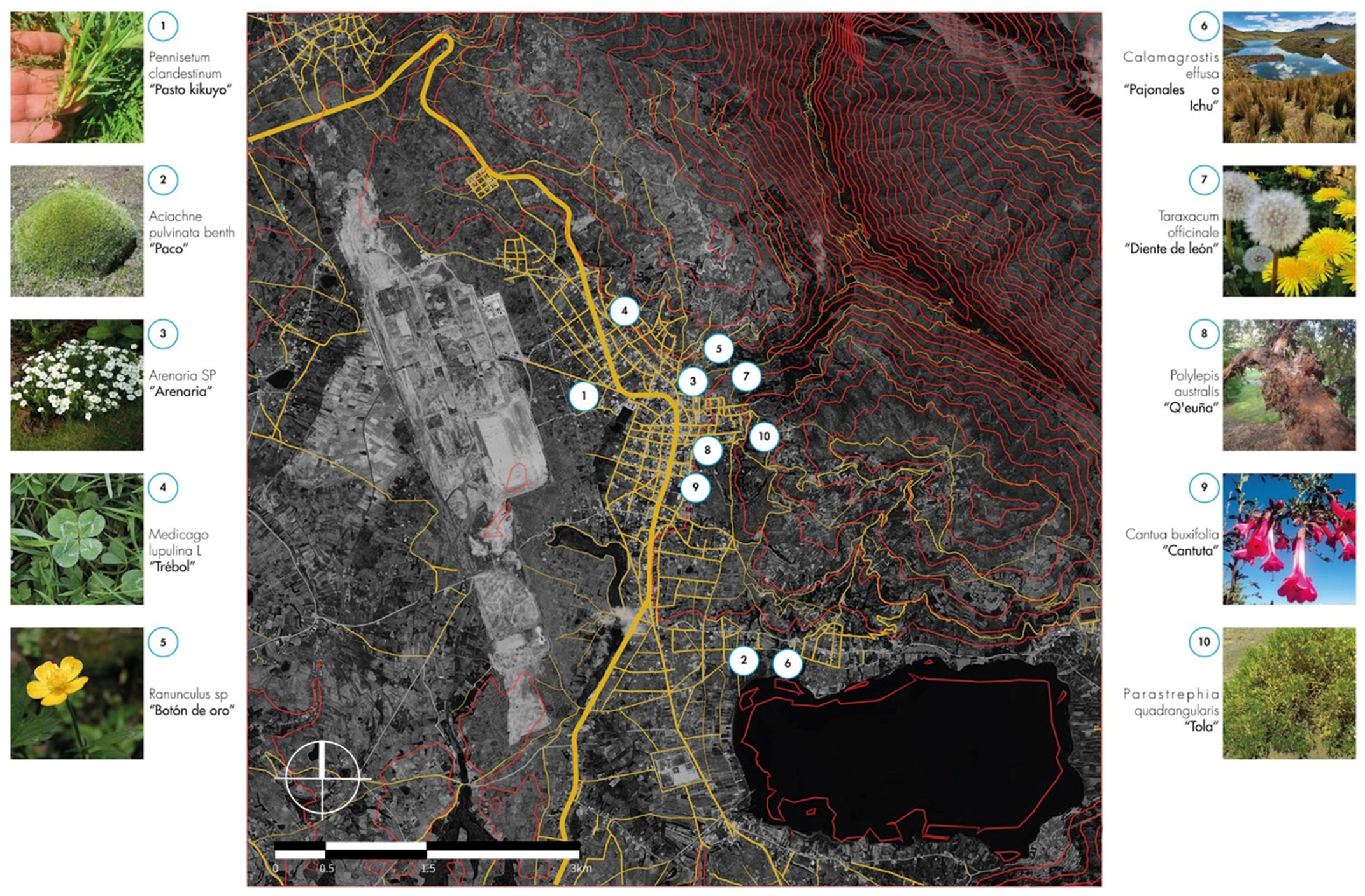
3.4.3. Flora
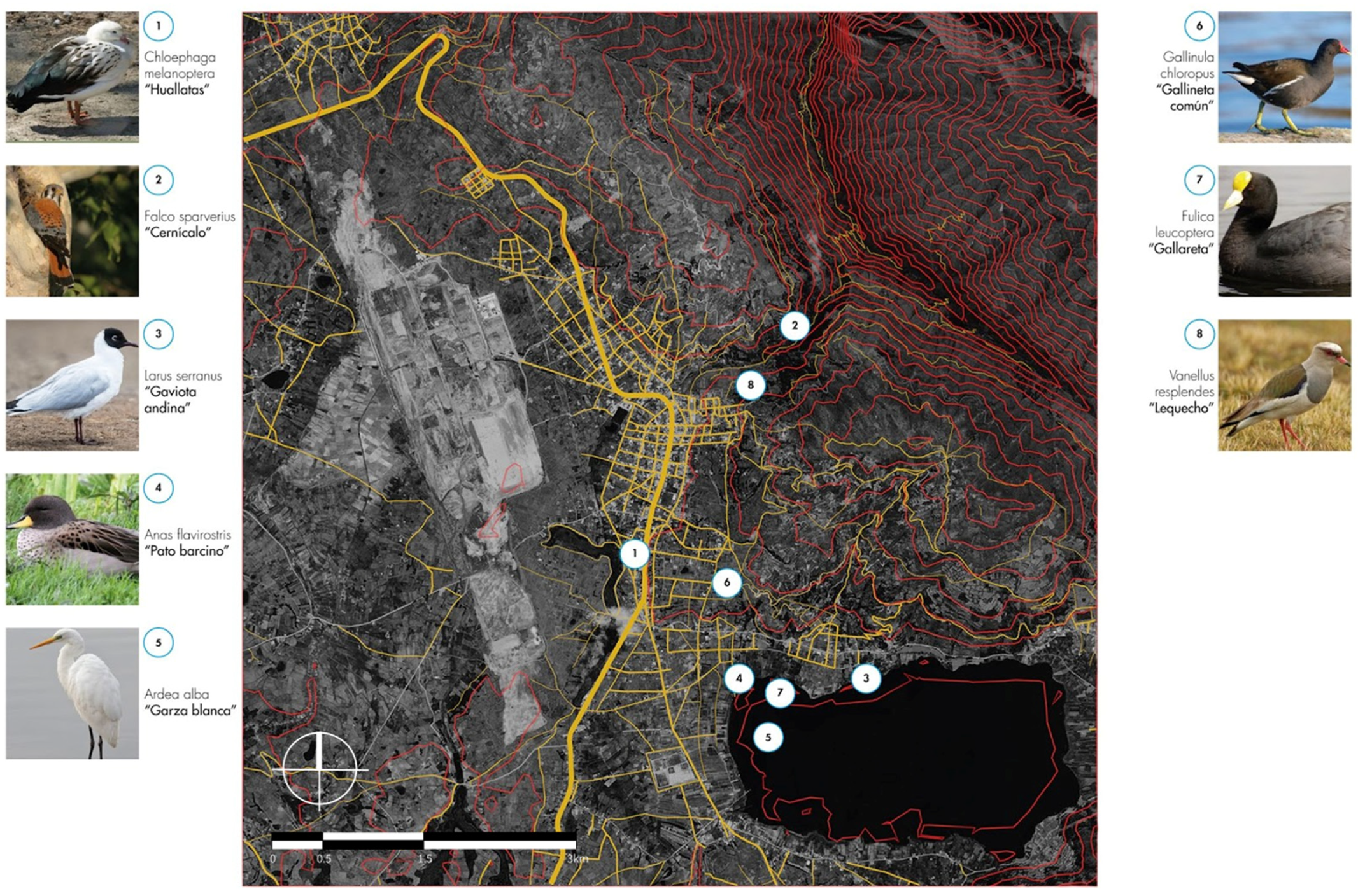
3.4.4. Fauna
4. Results
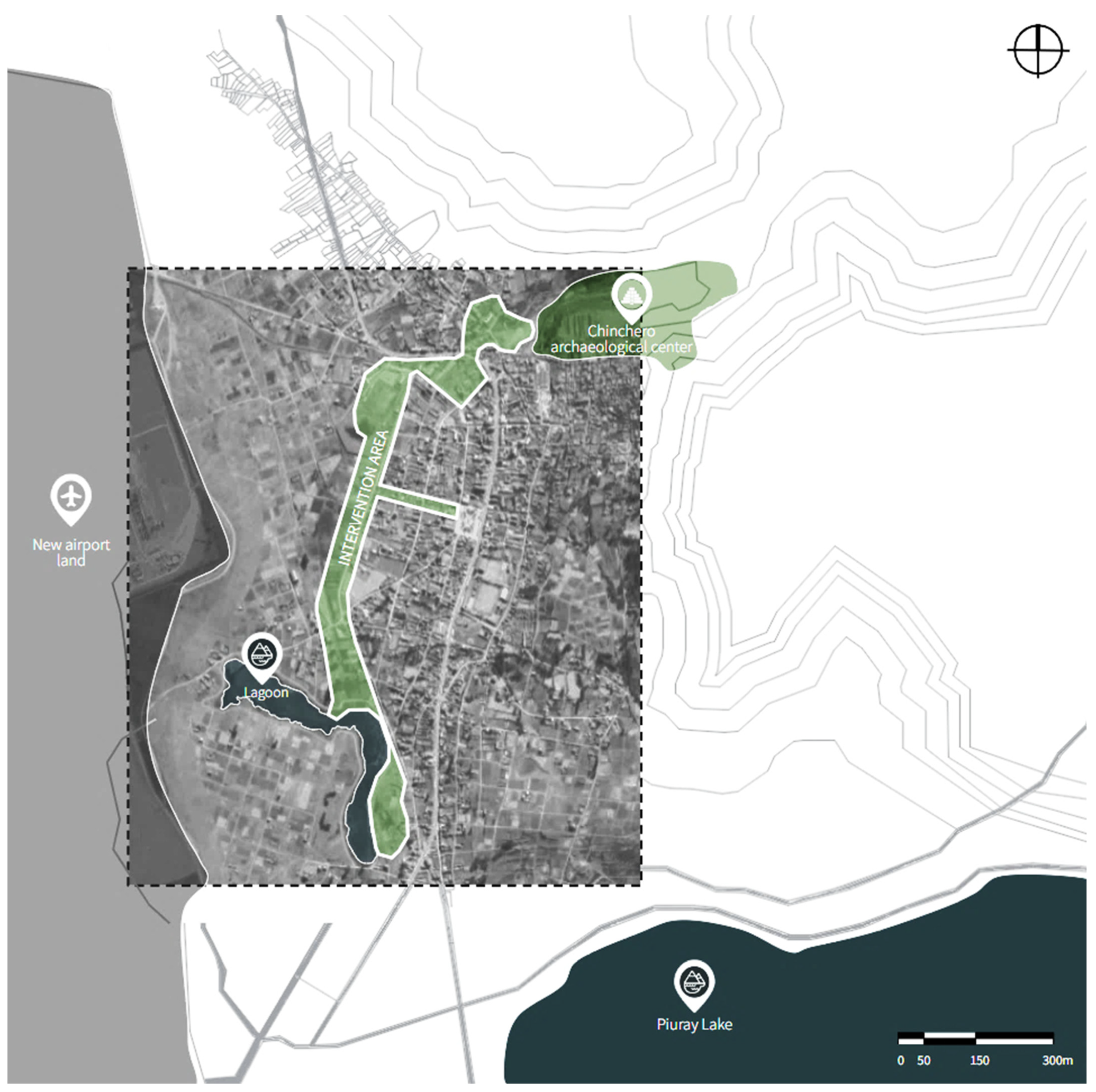
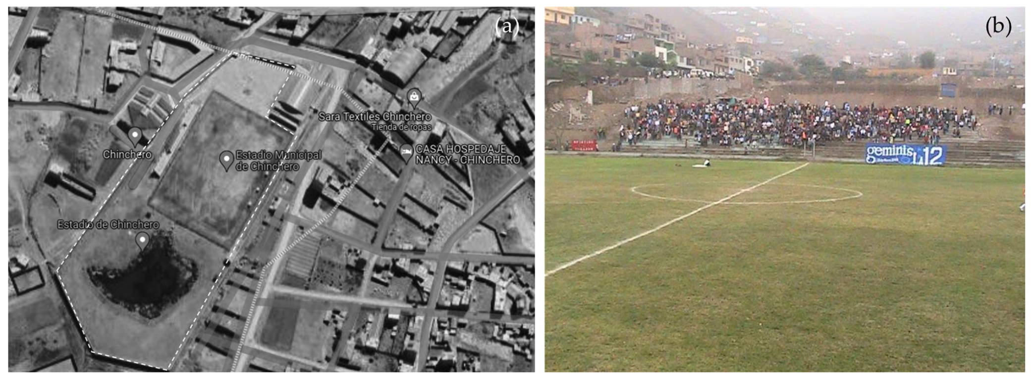
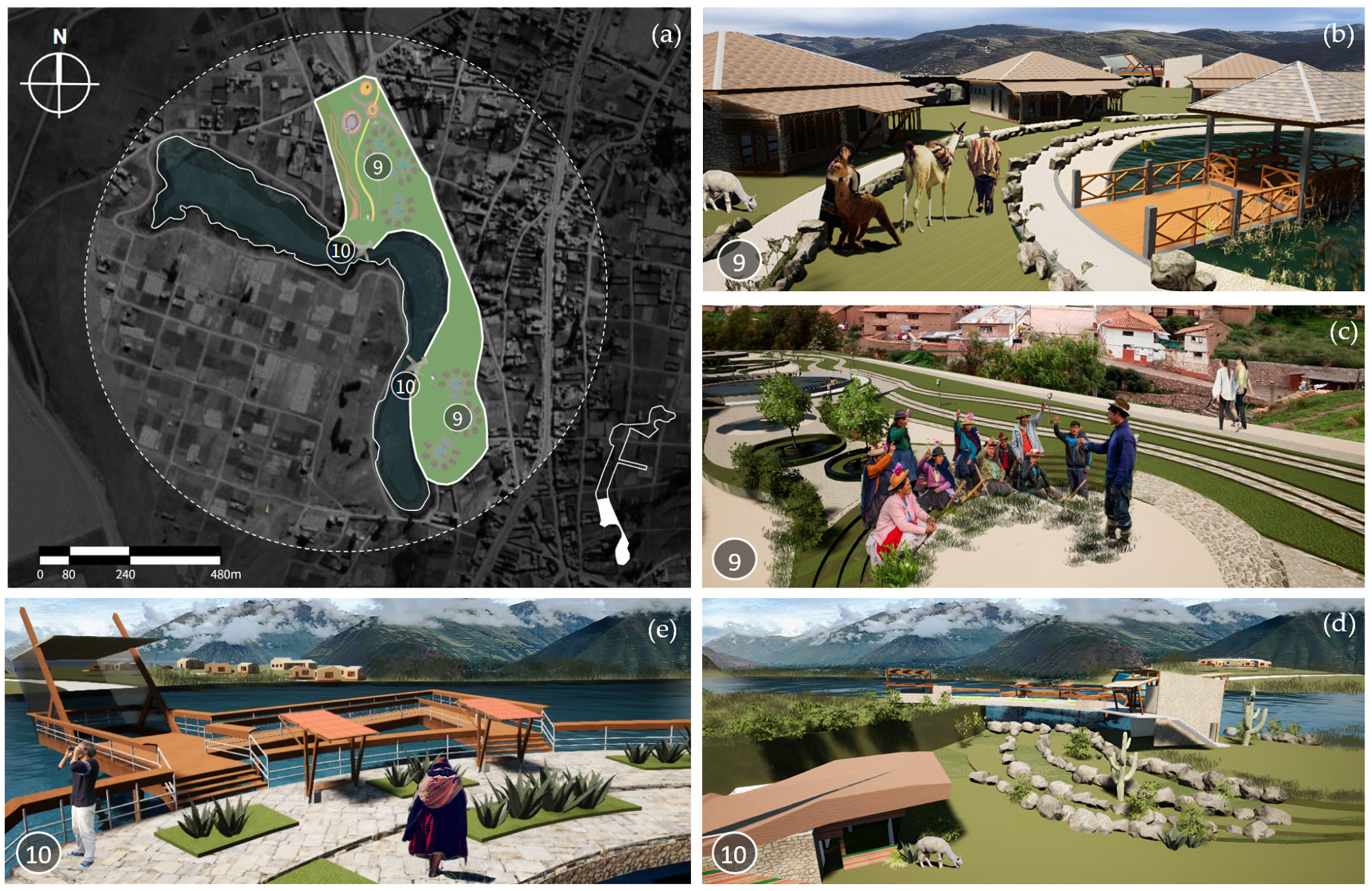
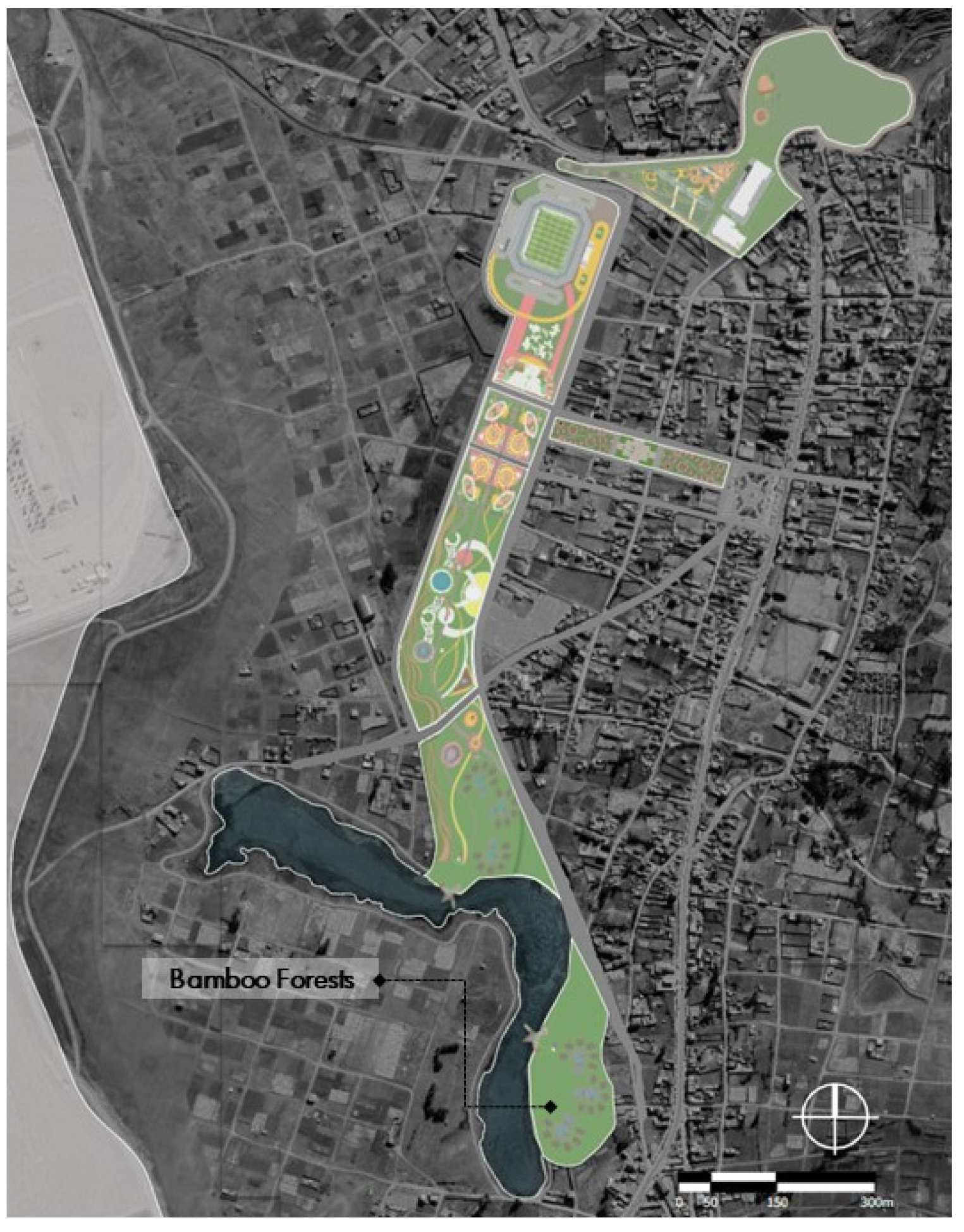
4.1. Location
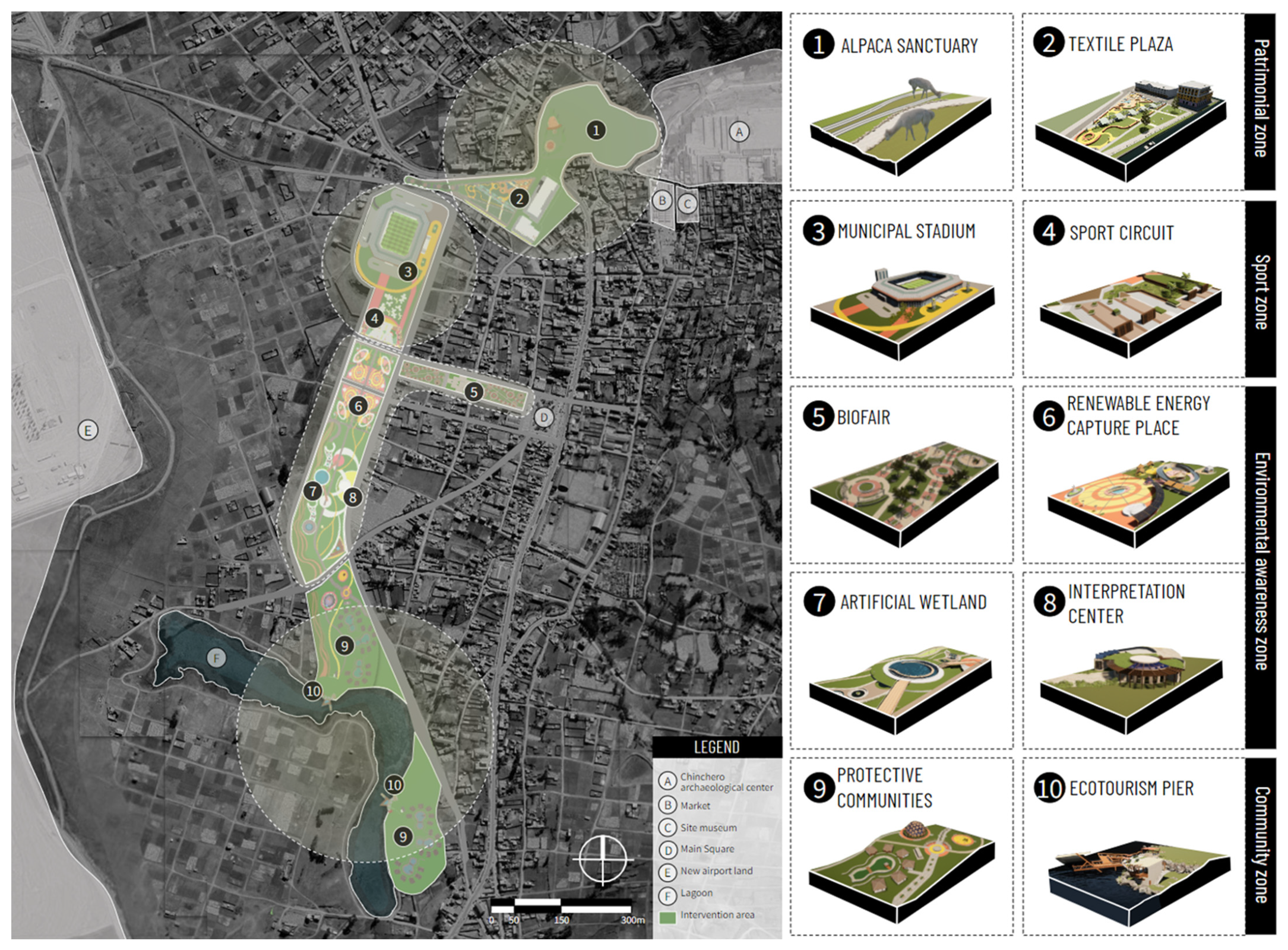
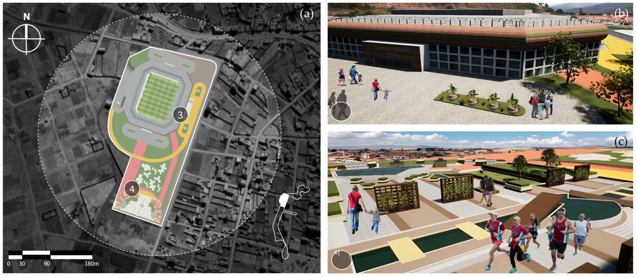
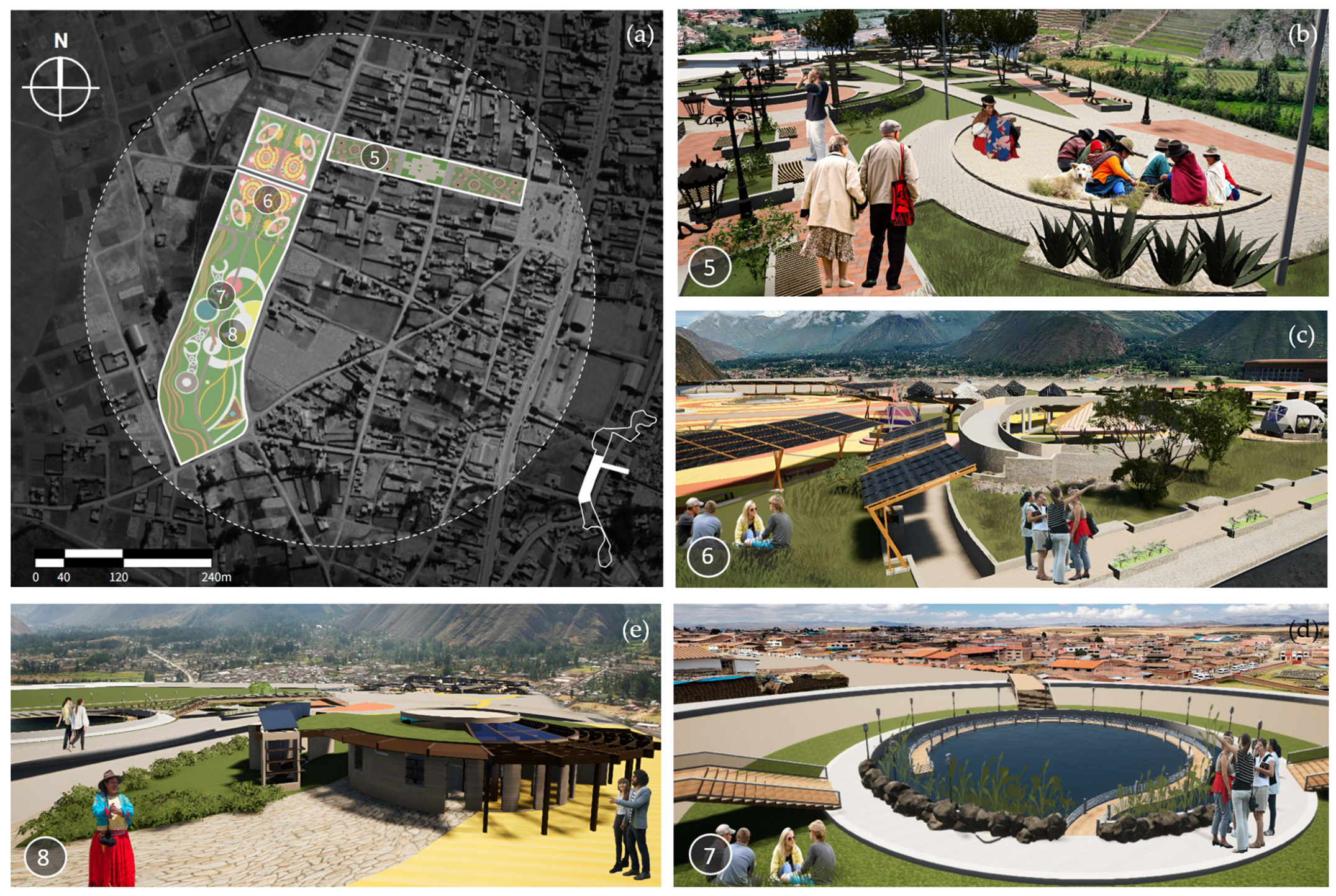
4.2. Master Plan
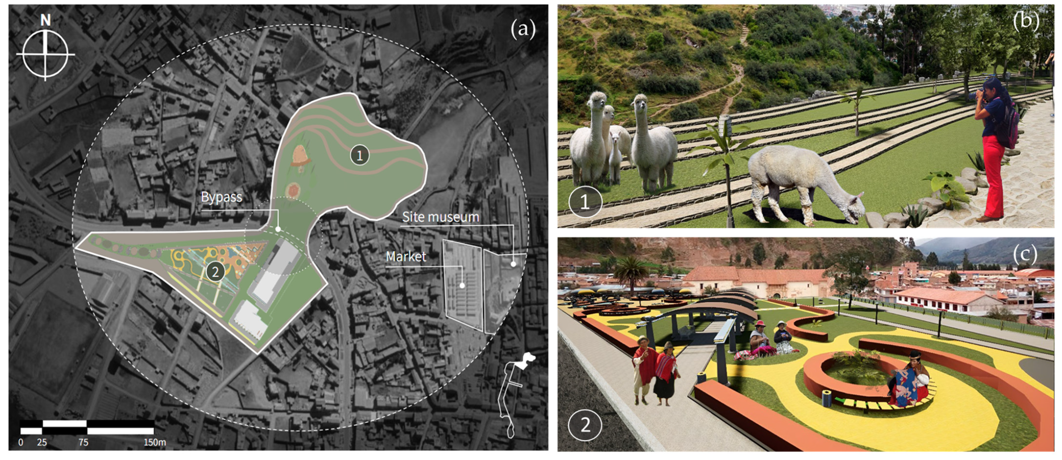
4.2.1. Patrimonial Zone
4.2.2. Sport Zone
4.2.3. Environmental Awareness Zone
Biofair
Renewable Energy Capture Place
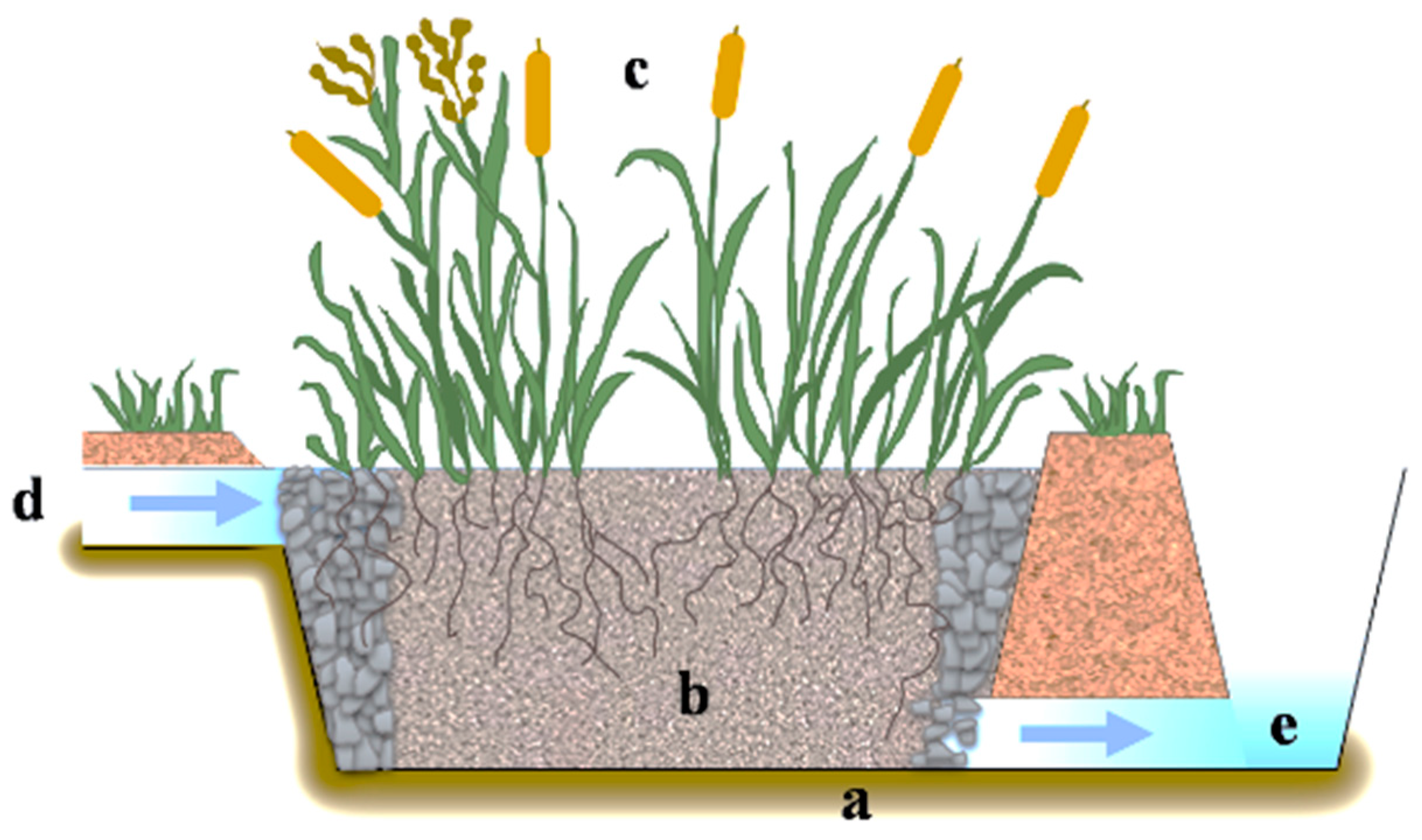
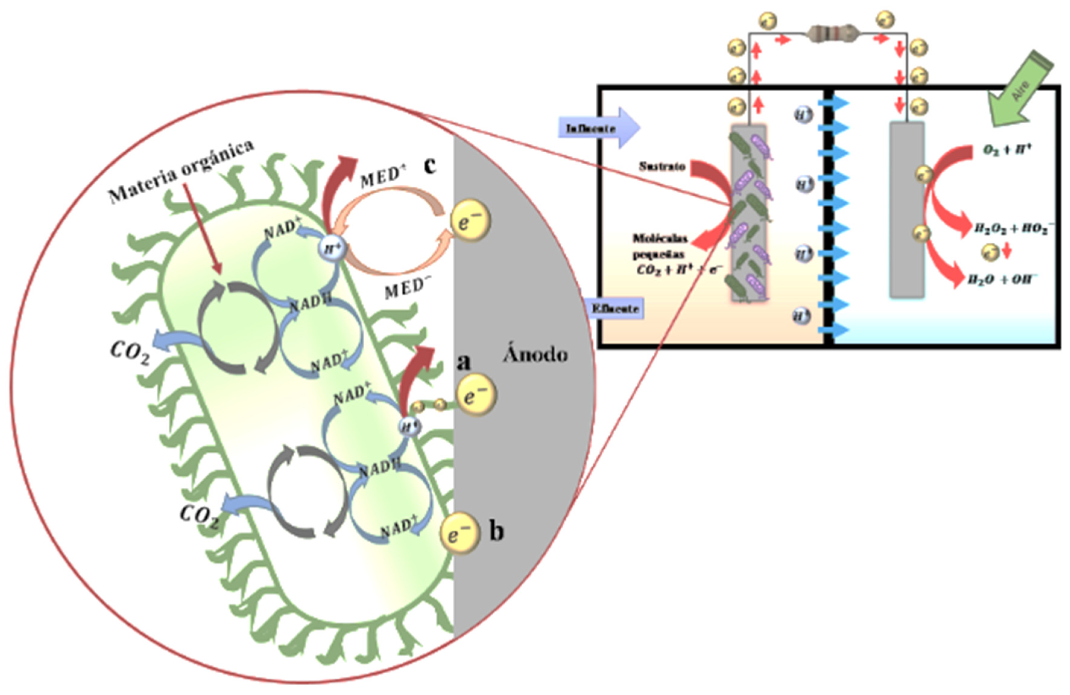
Artificial Wetland
Interpretation Center
4.2.4. Community Zone

5. Discussion
6. Conclusions
Author Contributions
Funding
Institutional Review Board Statement
Informed Consent Statement
Data Availability Statement
Conflicts of Interest
References
- Freestone, R. Planning, Sustainability and Airport-Led Urban Development. Int. Plan. Stud. 2009, 14, 161–167. [Google Scholar] [CrossRef]
- May, M.; Hill, S.B. Questioning airport expansion—A case study of Canberra International Airport. J. Transp. Geogr. 2006, 14, 437–450. [Google Scholar] [CrossRef]
- Damigos, D.; Laliotis, E. Estimating The Economic Benefits of Redeveloping The Former Athens International Airport. Environmental Economics and Investment Assessment III. WIT Trans. Ecol. Environ. 2010, 131, 39–49. [Google Scholar] [CrossRef]
- Quispe, M.; del Carmen, V. Impacto del Proyecto del Aeropuerto de Chinchero, en El Bienestar de la Población de la Comunidad Yanacona en el Distrito de Chinchero, Provincia de Urubamba, Departamento del Cusco, 2013–2021; Universidad Andina del Cusco: Cusco, Peru, 2022. [Google Scholar]
- PERÚ-INEI. Cusco: Resultados Definitivos de los Censos Nacionales 2017. Gob.pe. Available online: https://www.inei.gob.pe/media/MenuRecursivo/publicaciones_digitales/Est/Lib1559/ (accessed on 25 April 2023).
- Sánchez Valdés, A.; Icaza Castro, G.G.; Del Valle Pérez, M.; Jiménez-Ruiz, A.E.; De Jesús Contreras, D.; Palmas Castrejón, Y.D.; García Vargas, H.; Serrano Barquín, R.D.C.; Ramírez Hernández, O.I.; Camacho Gómez, M.D.S.; et al. Desarrollo, Cultura Y Administración en Espacios Turísticos; Universidad Autónoma del Estado de México: Toluca, Mexico, 2022. [Google Scholar]
- Paulino, I.; Prats, L.; Schofield, P. Tourist hub consumption systems: Convenient flexibility versus administrative constraint. J. Hosp. Tour. Manag. 2019, 41, 69–79. [Google Scholar] [CrossRef]
- Kim, H.S.; Lee, S.J. 서해안 관광권역 활성화 방안 (West Coast Tourism Area Revitalization Plan). CEo Report 2009, No.15. 2009. Available online: https://www.dbpia.co.kr/Journal/articleDetail?nodeId=NODE01431776 (accessed on 15 May 2023).
- Llorca-Rodríguez, C.M.; Casas-Jurado, A.; Soler-Domingo, A. Development of the Cuzco region: The Tourism Contribution. Ambiente Y Desarro. 2012, 16, 77–89. [Google Scholar]
- Cusco: Elaboran Plan de Desarrollo Urbano de Distrito de Chinchero. Andina.pe. Available online: https://andina.pe/agencia/noticia-cusco-elaboran-plan-desarrollo-urbano-distrito-chinchero-722939.aspx (accessed on 25 April 2023).
- El Proyecto de Aeropuerto Internacional Y El “Boom” de la Construcción en Chinchero. Revista Argumentos. Available online: https://argumentos-historico.iep.org.pe/articulos/proyecto-aeropuerto-internacional-boom-la-construccion-chinchero/ (accessed on 25 April 2023).
- Ministerio de Vivienda, Construcción y Saneamiento. Plan de Desarrollo Urbano de la Ciudad de Chinchero 2018–2028 Provincia de Urubamba Departamento de Cuzco; MVCS, Dirección general de políticas y regulación en vivienda y urbanismo: Cusco, Perú, 2023.
- Pipitone, J.M.; Jović, S. Urban green equity and COVID-19: Effects on park use and sense of belonging in New York City. Urban For. Urban Greening. 2021, 65, 127338. [Google Scholar] [CrossRef]
- Ministerio de Vivienda y Construcción y Saneamiento. 2005. Plan De Desarrollo Urbano Distrito de Chinchero. 2005–2015. Available online: https://eudora.vivienda.gob.pe/observatorio/PAZYDESARROLLO/APURIMAC_Chinchero/PDU-Chinchero.pdf (accessed on 12 May 2023).
- Liu, N.; Wang, Y.; Bai, Q.; Liu, Y.; Wang, P.S.; Xue, S.; Yu, Q.; Li, Q. Road life-cycle carbon dioxide emissions and emission reduction technologies: A review. J. Traffic Transp. Eng. 2022, 9, 532–555. [Google Scholar] [CrossRef]
- Ministerio de Ambiente. Zonas Priorizadas. 2001. Available online: https://www.minam.gob.pe/calidadambiental/zonas-priorizadas-de-calidad-del-aire/ (accessed on 8 April 2023).
- Diener, A.; Mudu, P. How can vegetation protect us from air pollution? A critical review on green spaces’ mitigation abilities for air-borne particles from a public health perspective—With implications for urban planning. Sci. Total Environ. 2021, 796, 148605. [Google Scholar] [CrossRef]
- Kumar, P.; Druckman, A.; Gallagher, J.; Gatersleben, B.; Allison, S.; Eisenman, T.S.; Hoang, U.; Hama, S.; Tiwari, A.; Sharma, A.; et al. The nexus between air pollution, green infrastructure and human health. Environ. Int. 2019, 133, 105181. [Google Scholar] [CrossRef]
- France-Mensah, J.; Kothari, C.; O’Brien, W.J.; Jiao, J. Integrating social equity in highway maintenance and rehabilitation programming: A quantitative approach. Sustain. Cities Soc. 2019, 48, 101526. [Google Scholar] [CrossRef]
- Alshahibi, A. Urban Green Belts in the Twenty-First Century. 2019. Available online: https://www.academia.edu/38856198/URBAN_GREEN_BELTS_IN_THE_TWENTY_FIRST_CENTURY (accessed on 25 April 2023).
- Vasquez, A.E. Infraestructura verde, servicios ecosistémicos y sus aportes para enfrentar el cambio climático en ciudades: El caso del corredor ribereño del río Mapocho en Santiago de Chile. Rev. De Geogr. Norte Gd. 2016, 63, 63–86. [Google Scholar] [CrossRef]
- Aguirre, S.D.; del Rosario, M. The Public Space as Backbone for Social Integration and as the Scenario of Civic Life. Universidad Cooperativa de Colombia. Available online: https://repository.ucc.edu.co/items/56296f1d-d726-4b5b-bce6-d154e2fb0af9 (accessed on 1 April 2023).
- Niemelä, J.; Breuste, J.H.; Guntenspergen, G.; McIntyre, N.E.; Elmqvist, T.; James, P. (Eds.) Urban Ecology: Patterns, Processes, and Applications; OUP Oxford: Oxford, UK, 2011. [Google Scholar]
- Marcus, L.; Colding, J. Towards a spatial morphology of urban social-ecological systems. In Proceedings of the 18th International Seminar on Urban form ‘Urban Morphology and the Post-Carbon city’, Montreal, QC, Canada, 26–29 August 2011; Available online: https://www.diva-portal.org/smash/get/diva2:469884/FULLTEXT01.pdf (accessed on 5 March 2023).
- Meerow, S. The politics of multifunctional green infrastructure planning in New York City. Cities 2020, 100, 102621. [Google Scholar] [CrossRef]
- Daniels, P.; El Baghdadi, O.; Desha, C.; Matthews, T. Evaluating net community benefits of integrating nature within cities. Sustain. Earth 2020, 3, 12. [Google Scholar]
- Forman, R. Some general principles of landscape and regional ecology. Landsc. Ecol. 1995, 10, 133–142. [Google Scholar] [CrossRef]
- Ramyar, R.; Ackerman, A.; Johnston, D.M. Adapting cities for climate change through urban green infrastructure planning. Cities 2021, 117, 103316. [Google Scholar] [CrossRef]
- McMahon, B.Y. Why Green infrastructure? Green Infrastructure: Linking Landscape and Communities; Island Press: Washington, DC, USA, 2006; Available online: https://plannersweb.com/wp-content/uploads/2000/01/372.pdf (accessed on 3 March 2023).
- Rößler, S.Y. Understanding the term green infrastructure: Origins, rationales, semantic content and purposes as well as its relevance for application in spatial planning. Land Use Policy 2020, 97, 104785. [Google Scholar]
- Dobbs, C.; Nitschke, C.R.; Kendal, D. Global Drivers and Tradeoffs of Three Urban Vegetation Ecosystem Services. PLoS ONE 2014, 9, e113000. [Google Scholar] [CrossRef] [PubMed]
- Baró, F.; Palomo, I.; Zulian, G.; Vizcaino, P.; Haase, D.; Gómez-Baggethun, E. Mapping ecosystem service capacity, flow and demand for landscape and urban planning: A case study in the Barcelona metropolitan region. Land Use Policy 2016, 57, 405–417. [Google Scholar] [CrossRef]
- Keeler, B.L.; Hamel, P.; McPhearson, T.; Hamann, M.H.; Donahue, M.L.; Prado, K.A.M.; Arkema, K.K.; Bratman, G.N.; Brauman, K.A.; Finlay, J.C.; et al. Social-ecological and technological factors moderate the value of urban nature. Nat. Sustain. 2019, 2, 29–38. [Google Scholar] [CrossRef]
- Cooperación alemana. Guía Para el Diseño de Corredores Verdes Urbanos: Experiencia de Loja. 2022. Available online: https://www.bivica.org/files/6332_Gu%C3%ADa%20para%20el%20dise%C3%B1o%20de%20Corredores%20Verdes%20Urbanos.pdf (accessed on 20 February 2023).
- Ministerio de Transportes y Comunicaciones. Aeropuerto Internacional de Chinchero-Cusco. 2014. Available online: https://portal.mtc.gob.pe/transportes/concesiones/infraestructura_aeroportuaria/aeropuerto_chinchero.html (accessed on 10 February 2023).
- Decreto Supremo-Nº 017-2007-MTC. Ministerio de Transportes y Comuniaciones. 2007. Available online: https://www.proviasdes.gob.pe/Prog_incentivos/Normatividad/Norm_sectorial_vinc_meta_40/DS_017_2007_Reglamento_Jerarquizacion.pdf (accessed on 10 February 2023).
- Gómez, N.; Guillermo, A. Velázquez. Asociación entre los espacios verdes públicos y la calidad de vida en el municipio de Santa Fe, Argentina. Cuad. Geogr. Rev. Colomb. Geogr. 2018, 27, 164–179. [Google Scholar] [CrossRef]
- Viceministerio de transportes, Dirección general de caminos y ferrocarriles. Manual de Carreteras Suelos Geología, Geotécnica y Pavimentos; Ministerio de transportes y comunicaciones: Lima, Perú, 2014. Available online: https://portal.mtc.gob.pe/transportes/caminos/normas_carreteras/MTC%20NORMAS/ARCH_PDF/MAN_7%20SGGP-2014.pdf (accessed on 14 December 2023).
- El Peruano. Especialistas Resaltan Beneficios Socioeconómicos que Traerá el Aeropuerto de Chinchero. Perú. 2021. Available online: https://elperuano.pe/noticia/121669-especialistas-resaltan-beneficios-socioeconomicos-que-traera-el-aeropuerto-de-chinchero (accessed on 14 December 2023).
- Plataforma digital única del Estado Peruano Plan COPESCO del Gobierno Regional Cusco socializó la Estrategia Regional Nodo Cusco-Chinchero ante la CCRT. Perú: RRPP. 2023. Available online: https://www.gob.pe/institucion/peplancopesco/noticias/858461-plan-copesco-del-gobierno-regional-cusco-socializo-la-estrategia-regional-nodo-cusco-chinchero-ante-la-ccrt (accessed on 14 December 2023).
- Instituto Nacional de Estadística e Informática. Cusco, Resultados definitivos. Perú. 2018. Available online: https://www.inei.gob.pe/media/MenuRecursivo/publicaciones_digitales/Est/Lib1559/08TOMO_01.pdf (accessed on 15 December 2023).
- Oficina de planificación y presupuesto. Unidad de Planeamiento y Racionalización. Plan de Desarrollo Local Concertado Chinchero al 2021. Perú: Municipalidad Distrital de Chinchero. 2016; pp. 58–62. Available online: https://cdn.www.gob.pe/uploads/document/file/3525132/PLAN%20LOCAL%20CONCERTADO-Municipalidad%20distrital%20de%20Chinchero%202021.pdf.pdf (accessed on 15 December 2023).
- Andina. Cusco: Firman Contrato Para Ejecutar Proyecto de Agua Potable en el Distrito de Chinchero. Perú. 2023. Available online: https://www.inei.gob.pe/media/MenuRecursivo/publicaciones_digitales/Est/Lib0867/libro.pdf (accessed on 15 December 2023).
- Dirección Desconcentrada de Cultura Cusco. Cartilla Informativa Marco Normativo Que Protege el Patrimonio Cultural de la Nación. Perú. 2017. Available online: https://www.culturacusco.gob.pe/wp-content/uploads/2017/07/DDC-Z.A.-DE-CHINCHERO-2021.pdf (accessed on 15 December 2023).
- Senamhi. Tiempo/Pronóstico Meteorológico. Perú. 2023. Available online: https://www.senamhi.gob.pe/main.php?dp=cusco&p=pronostico-meteorologico (accessed on 15 December 2023).
- Plan de Desarrollo Local Concertado Ampliación Chinchero al 2025. 2022. Available online: https://cdn.www.gob.pe/uploads/document/file/3525221/PLAN%20DE%20DESARROLL0%20LOCAL%20CONCERTADO%20AMPLIACION%20%20CHINCHERO%20AL%202025_.pdf.pdf (accessed on 15 December 2023).
- Vuille, M.; Francou, B.; Wagnon, P.; Juen, I.; Kaser, G.; Mark, B.G.; Bradley, R.S. Climate change and tropical Andean glaciers—Past, present and future. Earth Sci. Rev. 2008, 89, 79–96. [Google Scholar] [CrossRef]
- Aguilar-Lome, J.; Espinoza-Villar, R.; Espinoza, J.C.; Rojas-Acuña, J.; Willems, B.; Leyva-Molina, W.M. Elevation-dependent warming of land surface temperature in the Andes assessed using MODIS LST series (2000–2017). Int. J. Appl. Earth Obs. Geoinf. 2019, 77, 119–128. [Google Scholar] [CrossRef]
- Posthumus, H. Adoption of Terraces in the Peruvian Andes. Doctoral Thesis, Wageningen University, Wageningen, The Netherlands, 2005. [Google Scholar]
- Masson, F.L.; Cotler, H. Inventory, Evaluation and Use of the Terraces in the Rimac River Sub-Basin; National Council of Science and Technology: Lima, Peru, 1986.
- Kendall, A.; Rodríguez, A. Development and Perspectives of the Andenería Systems of the Central Andes of Peru; Institut français d’études andines: Cuzco, Peru, 2009. [Google Scholar] [CrossRef]
- Artificial Wetlands and Microbian Fuel Cells as Individual and Combined Systems for Wastewater Treatment: A Review; InfoAnalytics; Pontificia Universidad Católica del Ecuador: Quito, Ecuador, 2019; Volume 7.
- Rabaey, K.; Verstraete, W. Microbial fuel cells: Novel biotechnology for energy generation. Trends Biotechnol. 2005, 23, 291–298. [Google Scholar] [CrossRef] [PubMed]
- Logan, B.E.; Hamelers, B.; Rozendal, R.; Schröder, U.; Keller, J.; Freguia, S.; Aelterman, P.; Verstraete, W.; Rabaey, K. Microbial fuel cells: Methodology and technology. Environ. Sci. Technol. 2006, 40, 5181–5192. [Google Scholar] [CrossRef] [PubMed]
- Malvankar, N.S.; Lovley, D.R. Microbial nanowires for bioenergy applications. Curr. Opin. Biotechnol. 2014, 27, 88–95. [Google Scholar] [CrossRef] [PubMed]
- Gómez, A.; Esenarro, D.; Martinez, P.; Vilchez, S.; Raymundo, V. Thermal Calculation for the Implementation of Green Walls as Thermal Insulators on the East and West Facades in the Adjacent Areas of the School of Biological Sciences, Ricardo Palma University (URP) at Lima, Peru 2023. Buildings 2023, 13, 2301. [Google Scholar] [CrossRef]
- Avilés, M.; Emilio, H.; Bustamante, M.; Manuel, E.; del Salto, R.; Mercedes, J. Potencial económico de los cañaverales de bambú de la zona 5 del Ecuador en el comercio de emisiones. Rev. Univ. Y Soc. 2019, 11, 377–386. [Google Scholar]
- Aprobados Los Planes Especiales de Protección Y Mejora de la Infraestructura Verde, Un Gran Avance Para El Proyecto Bosque Metropolitano de Madrid. Available online: https://estrategiaurbana.madrid.es/2023/03/31/aprobados-los-planes-especiales-de-proteccion-y-mejora-de-la-infraestructura-verde-un-gran-avance-para-el-proyecto-bosque-metropolitano-de-madrid/ (accessed on 10 March 2023).
- Bosque Metropolitano. Available online: https://www.madrid.es/portales/munimadrid/es/Inicio/Vivienda-urbanismo-y-obras/Urbanismo/Bosque-Metropolitano/?vgnextfmt=default&vgnextoid=effb3c0a55e16710VgnVCM1000001d4a900aRCRD&vgnextchannel=2af331d3b28fe410VgnVCM1000000b205a0aRCRD (accessed on 26 February 2023).
- Jiménez Garcinuño, L. Urban occupation dynamics of Madrid’s Metropolitan Greenbelt. Cuad. Investig. Urbanística 2017, 5. [Google Scholar] [CrossRef][Green Version]
- El parque agrícola de Milán. Un Referente Internacional en la Conformación Urbana Contemporánea; Trabajo Fin de Grado; Universidad de Zaragoza, EINA: Zaragoza, Spain, 2015; Available online: https://zaguan.unizar.es/record/48235?ln=es# (accessed on 15 December 2023).
- Echeverry-Tamayo, J.D. Medellín: Una ciudad de encrucijadas. Pobreza, modelo de ciudad y cambio social en el proyecto Cinturón Verde. Territorios 2019, 40, 273–289. [Google Scholar] [CrossRef]
- Ministerio de Vivienda, Construcción y Saneamiento Decreto Supremo N° 012-2022-VIVIENDA. Available online: https://www.gob.pe/institucion/vivienda/normas-legales/3588833-012-2022-vivienda (accessed on 15 July 2023).


| Activity | PM10 | SOX | NOX | CO | VOC | Pb |
|---|---|---|---|---|---|---|
| Solvents and paint | 0.0 | 0.00 | 0.00 | 0.00 | 282.83 | 0.00 |
| Food manufacturing | 664.2 | 0.00 | 0.00 | 0.00 | 0.00 | 0.00 |
| Sawmills and carpentry | 3.8 | 0.00 | 0.00 | 0.00 | 4.57 | 0.00 |
| Printers | 0.0 | 0.00 | 0.00 | 0.00 | 1.71 | 0.00 |
| Brick making | 1067.3 | 7.96 | 55.75 | 5574.44 | 1831.93 | 0.00 |
| Use of boilers and heaters | 0.7 | 26.63 | 6.45 | 3.77 | 1.41 | 0.00 |
| Rotisseries | 38.3 | 0.78 | 2.08 | 132.27 | 41.62 | 0.00 |
| Bakeries | 134.3 | 5.41 | 13.37 | 1252.94 | 526.68 | 0.00 |
| Fuel sales | 0.0 | 0.00 | 0.00 | 0.00 | 135.67 | 0.00 |
| Vehicular transport | 148,989.4 | 605.33 | 2437.47 | 6848.87 | 1264.94 | 30.26 |
| Air transport | 5.0 | 7.60 | 72.00 | 0.00 | 103.40 | 0.00 |
| Laundries | 0.0 | 0.00 | 0.00 | 0.00 | 112.80 | 0.00 |
| Houses | 650.2 | 45.89 | 97.41 | 3944.96 | 1994.69 | 0.00 |
| Code | Typology | Length | Surface |
|---|---|---|---|
| PE-28J Emp. PE-28F (Chinchero) | National road | 6.245 km | Affirmed |
| Platform | Platform Profile | Retaining Wall | Irrigation System |
|---|---|---|---|
| (Type 1) | Horizontal | Inclined | Yes |
| (Type 2) | Horizontal | Vertical | Yes and no |
| (Type 3) | Inclined | Rustic | Generally not |
| (Type 4) | Without platform profile | Without retaining wall | Not |
| Landscaped Green Area in Green Corridor (ha²) | Absorbed CO₂ (kg) | Produced Fresh Air (kg) | |
|---|---|---|---|
| 1 | 9.20 | 21.16 | 15.64 |
| Total | 9.20 | 21.16 | 15.64 |
| Green Bamboo Forest Area (ha²) | Absorbed CO₂ (ton) | |
|---|---|---|
| 1 | 2.2 | 47.11 |
| Total | 2.2 | 47.11 |
Disclaimer/Publisher’s Note: The statements, opinions and data contained in all publications are solely those of the individual author(s) and contributor(s) and not of MDPI and/or the editor(s). MDPI and/or the editor(s) disclaim responsibility for any injury to people or property resulting from any ideas, methods, instructions or products referred to in the content. |
© 2024 by the authors. Licensee MDPI, Basel, Switzerland. This article is an open access article distributed under the terms and conditions of the Creative Commons Attribution (CC BY) license (https://creativecommons.org/licenses/by/4.0/).
Share and Cite
Esenarro, D.; Cho, A.; Vargas, N.; Calderon, O.; Raymundo, V. Chinchero as Tourism Hub and Green Corridor as a Social Integrator in Cusco Peru 2023. Sustainability 2024, 16, 3068. https://doi.org/10.3390/su16073068
Esenarro D, Cho A, Vargas N, Calderon O, Raymundo V. Chinchero as Tourism Hub and Green Corridor as a Social Integrator in Cusco Peru 2023. Sustainability. 2024; 16(7):3068. https://doi.org/10.3390/su16073068
Chicago/Turabian StyleEsenarro, Doris, Alejandro Cho, Nalia Vargas, Oscar Calderon, and Vanessa Raymundo. 2024. "Chinchero as Tourism Hub and Green Corridor as a Social Integrator in Cusco Peru 2023" Sustainability 16, no. 7: 3068. https://doi.org/10.3390/su16073068
APA StyleEsenarro, D., Cho, A., Vargas, N., Calderon, O., & Raymundo, V. (2024). Chinchero as Tourism Hub and Green Corridor as a Social Integrator in Cusco Peru 2023. Sustainability, 16(7), 3068. https://doi.org/10.3390/su16073068