Abstract
The essential significance of forest ecological corridors primarily revolves around their role in enhancing and maintaining balance in the ecological environment. However, an aspect that has not been adequately addressed is their potential in terms of recreational services. Focusing on the main urban area of Daqing City, this research investigates the integration of ecological and recreational objectives, adopting an “ecology-humanity” composite perspective. (1) Morphological Spatial Pattern Analysis (MSPA) and connectivity analyses were employed to identify ecological sources and construct an ecological resistance framework, and potential corridors were then delineated under ecological scenarios using the Minimum Cumulative Resistance (MCR) model; (2) then, the resistance system was refined using ArcGIS network analysis to identify potential corridors for recreational scenarios; (3) finally, this study examined the network layout of ecological and recreational routes, aiming to integrate an optimal humanistic configuration of forest ecological corridors that aligns with dual objectives. The spatial distribution of forest ecological corridors in Daqing City’s main urban area reveals a pattern where densely constructed areas predominantly feature recreational corridors and less-developed regions are characterized by ecological corridors. Ecological composite corridors serve as crucial links between these types of areas, mainly enhancing the urban layout and refining its structure.
1. Introduction
Forest ecological corridors represent a vital green framework of urban ecosystems, acting as linear or band-shaped landscape elements. They intricately weave the city’s ecological fabric into a cohesive unit [1]. The development of these ecological networks enhances urban accessibility and continuity [2], facilitates species migration, and amplifies the region’s ecological service capabilities [3]. By seamlessly integrating fragmented ecological zones into dispersed human-centric areas, these corridors optimize the ecological and recreational utility of each segment [2,4]. Consequently, the establishment of forest ecological corridors serves a dual purpose: it enriches the urban ecological landscape and fosters balanced urban development, underscoring its significant ecological and humanistic importance.
In the realm of multifunctional forest ecological corridor research, Liu Xinrong et al. [5] focused on the central area of Luoyang city, amalgamating three distinct functions to design a network encompassing ecological, heritage, and commuter corridors. Zhang Yali et al. [6] envisioned a resource-efficient ecological network for Dongshan Island, prioritizing ecological conservation. Similarly, Wang et al. [7] explored the interplay between greenways and low-carbon urban living, advocating for the integration of greenways into the fabric of urban low-carbon initiatives. Li Fangzheng et al. [4] examined Qian’an city’s greenway development, evaluating it within the framework of a low-carbon city concept [8,9,10]. The construction of forest ecological corridors is considered an important means to improve the quality and functionality of urban ecosystems; however, there are several notable limitations. Research primarily focuses on specific types of cities and specific areas, with insufficient exploration into designing ecological–humanistic composite forest ecological corridors across different city types, developmental goals, and urban challenges. Additionally, there is a significant challenge in determining how to balance multiple interests while pursuing ecological value realization, necessitating more detailed and specific research to find a balance. This highlights the need for a broadened research scope to include diverse urban environments and the complex interplay of ecological and humanistic values within them.
Addressing these limitations, this study refines several key scientific questions. (1) How can adaptive ecological–humanistic composite forest ecological corridors and stages of development be designed in order to meet the diverse objectives and challenges of urban development? (2) In the face of challenges, such as reduced ecological continuity, increased habitat fragmentation, and declining biodiversity in cities, how can forest ecological corridors be effectively utilized to restore ecosystems, promote biodiversity conservation, and enhance urban ecological service functions? (3) How can the emphasis on ecological protection be balanced with the coordination of multiple interests in urban development, especially in cities with a strong dependence on resources, in order to achieve diversified economic development and maximize ecological values?
This study uses the main urban area of Daqing, a quintessential resource-based city, as a case study, identifying the principal factors influencing the city’s sustainable development, including ecological degradation, economic reliance on non-renewable resources, and the need for diversified economic development strategies, and positions ecological emphasis as the fundamental guideline for constructing forest ecological corridors. Adopting the dual lens of “ecological protection and recreational function”, this study underscores how ecological corridors can enhance the human ecological environment, emphasizes their role in coordinating recreational activities and guiding the logical organization of urban spaces, and offers insights for the development of forest ecological networks in cities oriented towards resource utilization.
2. Materials and Methods
2.1. Study Area Overview
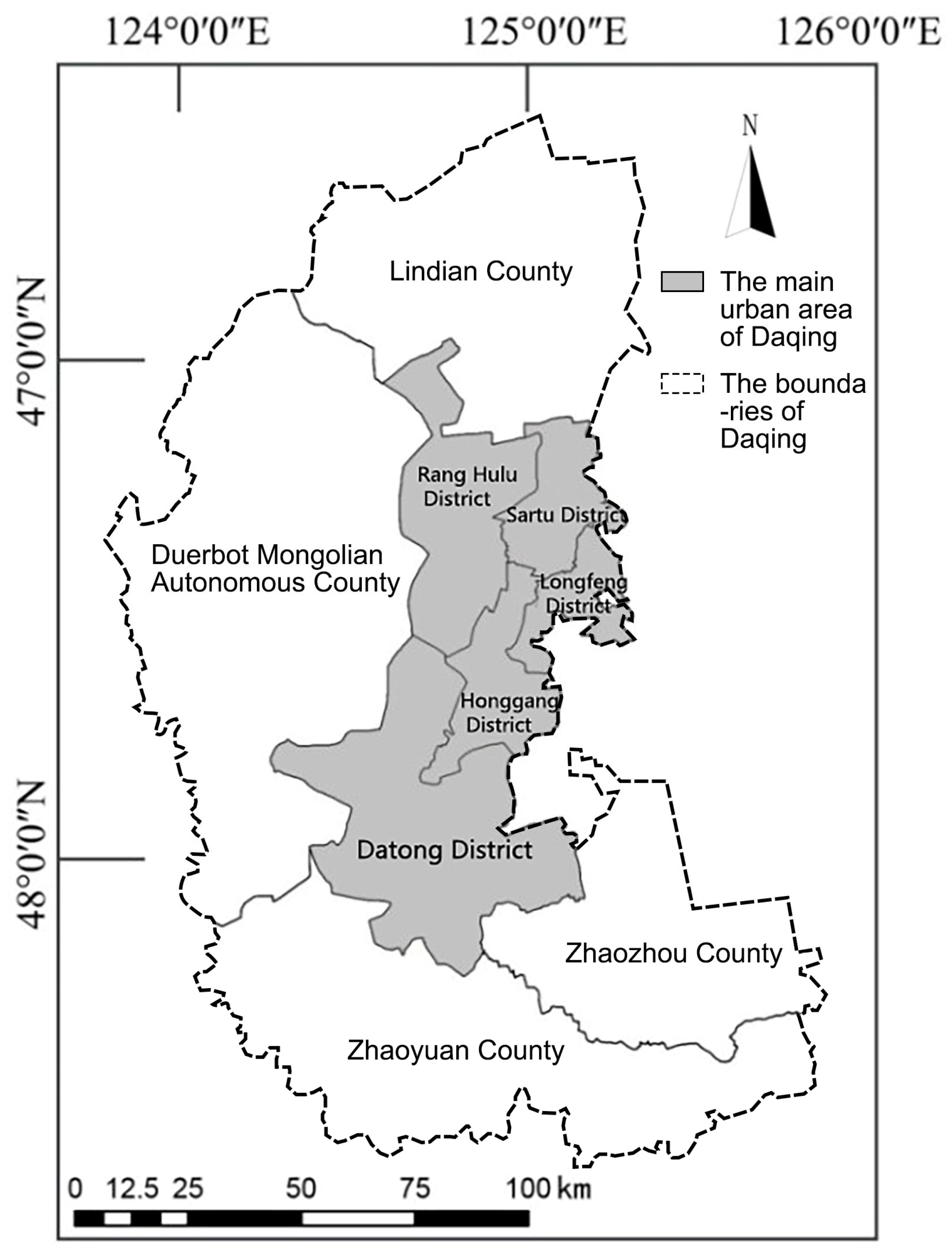
Daqing, renowned as a petroleum-centric city, has evolved in tandem with the development of its oil fields and the burgeoning oil economy. Situated in the southwestern region of Heilongjiang Province, it spans from 45°46’ N to 46°55’ N latitude and 124°19’ E to 125°12’ E longitude (Figure 1) and experiences a temperate monsoon climate. The city encompasses five municipal districts, three counties, one autonomous county, and a national high-tech industrial development zone, covering a total area of approximately 2,121,900 hm2. Specifically, this study focuses on the main urban area, accounting for 504,900 hm2. As a prototypical resource-based city, Daqing’s urban structure is characterized by a dispersed town layout, deviating from a centralized urban core in favor of multiple satellite towns. This configuration has implications for urban cohesion and efficiency, such as traffic congestion and a sparse road network [11,12]. Ecologically, the city faces challenges, such as urban green space fragmentation, biodiversity loss, and diminished landscape functionality and connectivity, all of which impinge on Daqing’s green development prospects. However, Daqing also boasts unique natural and cultural assets, including its iconic oil heritage, diverse wetland landscapes, wildlife, and therapeutic hot springs [13]. This study aims to harmonize these fractured ecological settings with the city’s rich tourism potential. Furthermore, this research intends to delineate a path for the development of humanistic composite forest ecological corridors in Daqing’s main urban area, thus integrating ecological and recreational elements into the urban fabric.
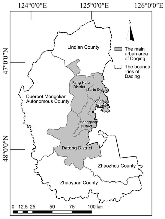
Figure 1.
Study area location.
2.2. Data Sources and Pre-Processing
This study utilized Landsat 8 OLI multispectral remote sensing imagery and 30 m resolution Digital Elevation Model (DEM) data of Daqing City from September 2019 (data source: http://www.gscloud.cn/ (accessed on 8 June 2023)). These specific datasets were selected due to their high resolution and comprehensive coverage, which are instrumental in capturing the intricate patterns of land use and land cover during this pivotal year. The integration of these precise and high-quality satellite images and elevation data enhances our analysis, enabling a more accurate and detailed examination of the environmental and socio-economic dynamics at play. The data were processed using ENVI 5.2 software for radiometric calibration, atmospheric correction, image mosaicking, and cropping to match the administrative boundaries of Daqing City. Supervised classification employing the maximum likelihood method was applied, with the accuracy of the classification results further refined by integrating high-resolution Google Earth imagery from the same period and corroborating with field research findings. Subsequent post-classification processing included patch elimination and clustering to refine the interpretation results. This study utilized the Daqing City Master Plan (2011–2020) and the Classification of Current Land Use Situations [14] (GB/T 21010-2017) standards to derive a detailed land use classification map for the main urban area of Daqing City. In the context of using ENVI 5.3 software for precision assessment of remote sensing data, a methodology involving confusion matrix comparison against expert-selected ground truth locations is employed. This approach dictates the random selection of 500 points within the study area, ensuring that no less than 40 points are chosen within each identified category of terrain or land use type. These points are then verified through field surveys to validate the accuracy of the remote sensing interpretations. The overall accuracy of the remote sensing data interpretation is confirmed to be 96.18%.
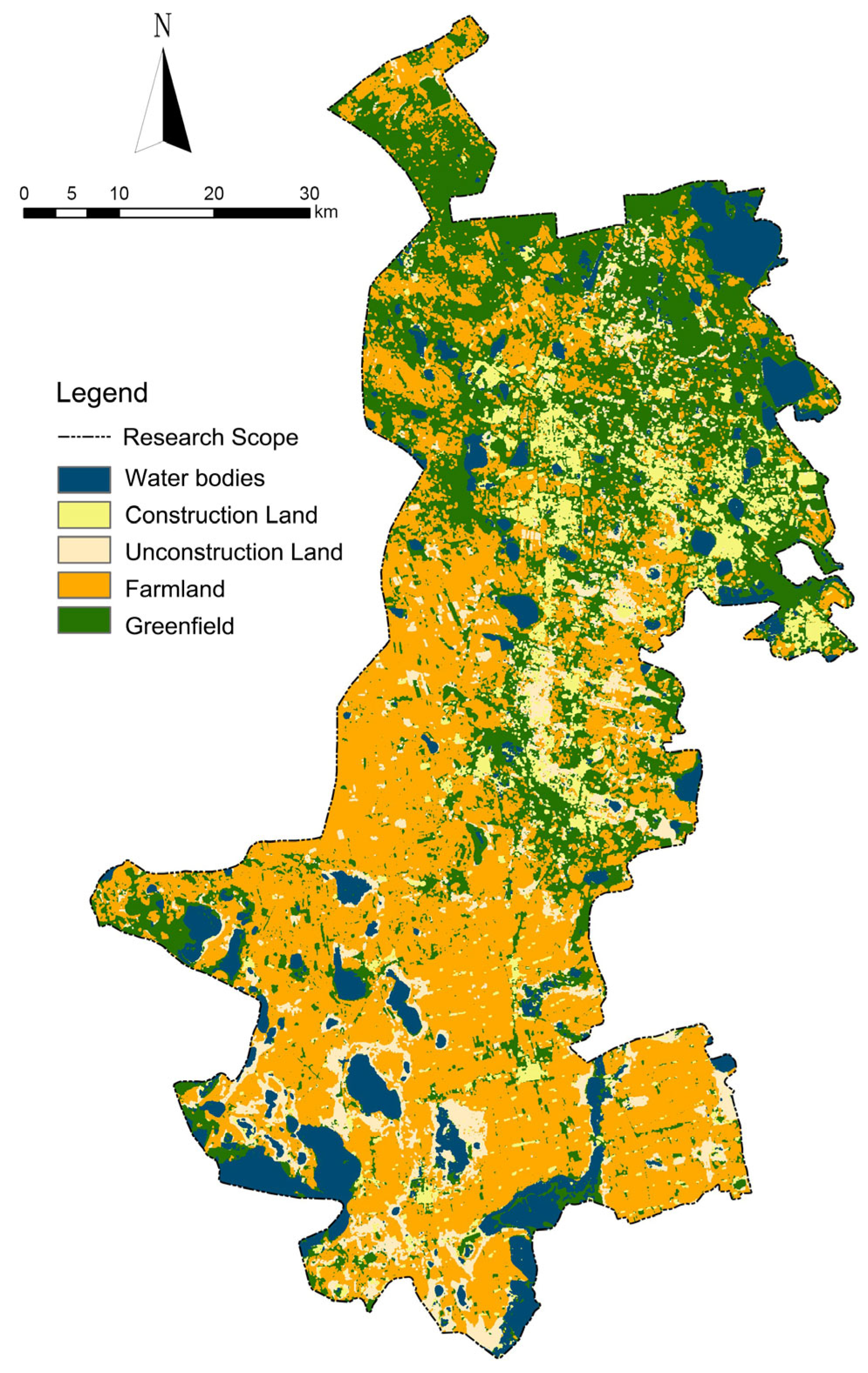
This map, with a raster accuracy of 30 m × 30 m, categorizes the area into water bodies, constructed land, unbuilt land, farmland, and green land (Figure 2). Water bodies are a key feature scattered throughout, with noticeable clusters in the southern part of the region. Constructed land is central and is indicative of densely populated towns or city centers, while the interspersed unconstructed land suggests potential space for future development or currently vacant plots. Farmland dominates as the primary land type, especially toward the central and northern parts of the area, signifying agriculture as an essential aspect and a backbone of the regional economy. Greenfield areas are not as concentrated; they are mainly located on the periphery of constructed land, representing urban green belts, natural reserves, or other forms of undeveloped land. Despite the apparent dominance of natural landscapes, the existing and potential development areas present unique opportunities to explore the sustainability of urban expansion in the context of preserving natural resources and maintaining ecological balance. Additionally, data on Daqing City’s road network were obtained from the Open-StreetMap website, as well as various planning documents, such as the Daqing Urban Comprehensive Transportation System Planning (2010–2020) and Daqing Rail Transit Recent Construction Planning (2019–2025). This information is crucial for understanding the spatial layout and planning of road networks within the main urban area of Daqing City.

Figure 2.
The main city of Daqing City 2019 land use status.
2.3. Research Methodology
2.3.1. MSPA-Based Ecological Source Site Identification
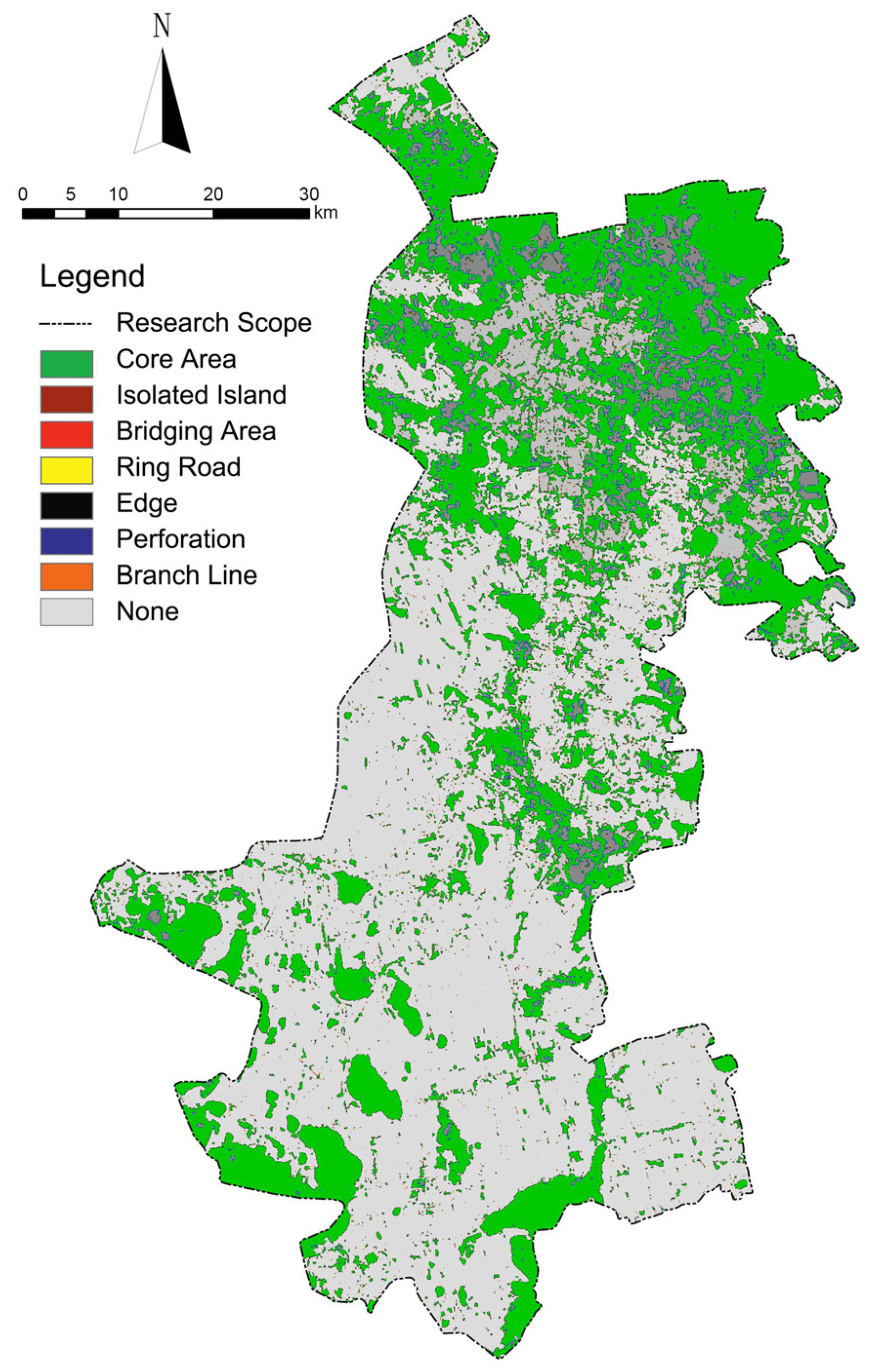
Ecological sources are fundamental to the establishment of corridor networks, emphasizing the importance of prioritizing the scientific identification and extraction of these ecological sources, especially in the context of ecological conservation. Recent advancements in Morphological Spatial Pattern Analysis (MSPA) have proven instrumental in enhancing objectivity and scientific integrity in identifying ecological source areas and extracting ecological corridors. MSPA’s robust structural connectivity attributes, facilitated by meticulously calibrated parameters, play a pivotal role in this process. The edge width parameter, tailored according to our data’s spatial resolution, is crucial for accurately capturing landscape features without overestimating edge effects, ensuring that edges are appropriately defined to reflect actual landscape boundaries. Moreover, the transition parameter has been carefully calibrated to optimally detect the subtle transitions between different land cover types, enhancing the morphological classification’s accuracy by identifying ecotones and landscape heterogeneity. This provides a more nuanced understanding of the area under study. Additionally, the intext (internal texture) parameter, adjusted to distinguish between various land cover types based on texture characteristics observable in satellite imagery, improves classification accuracy by considering the internal pattern of classified patches, which is essential for differentiating between similar-looking areas with different functional characteristics. Furthermore, the foreground connectivity (FG connectivity) setting ensures that only patches with significant spatial connectivity are classified as being in the foreground, which is critical for accurately delineating built-up areas from natural landscapes. This method not only categorizes and plans these landscapes but also mitigates the subjective bias inherent in direct identification methods for selecting natural resource points, thereby improving the overall accuracy of the MSPA analysis. Consequently, MSPA enhances the identification and planning of landscapes, which is pivotal for maintaining ecological connectivity at the image element level, thereby supporting the scientific extraction of ecological corridors [15].
This study utilized 2019 land use classification data from the main urban area of Daqing City (Figure 2), focusing on the role of different land types in the development of forest ecological corridors. Green areas and water bodies were extracted as the foreground values of ecological source land elements. In contrast, farmland, constructed land, and unconstructed land were designated as the background values [16], emphasizing the importance of green areas and water bodies over farmlands, which are primarily used for agricultural production, indirectly providing urban ecological services. Thus, this study focuses on those land use types that inherently support urban ecology, based on the specific context and goals of urban green infrastructure enhancement. A binary map was analyzed using MSPA with Guidos software (version 3.0), employing the eight-neighborhood rule [17]. This analysis yielded seven distinct, non-overlapping landscape types: core, isolated island, bridging, loop, edge, perforation, and spur [18,19]. The implications of these results are further discussed in the context of enhancing corridor network construction.
The level of landscape connectivity can quantitatively express whether landscape patches are favorable for species migration and whether good connectivity is favorable for maintaining ecological diversity. Utilizing Conefor2.6 software, based on a raster scale of 30 m (pixel size) × 30 m (edge width), three landscape connectivity indices of overall connectivity (IIC), probable connectivity (PC), and patch importance (dI) [20] were selected. The connectivity distance threshold was meticulously set to 1000 m after a detailed review of landscape features and preliminary analyses that indicated that this distance optimally captures the connectivity relevant to our urban and peri-urban focus. Similarly, the connectivity probability was carefully chosen to be 0.5 [21,22], aiming to provide a balanced view of connectivity that mitigates the risk of over- or underestimation in the fragmented habitats under investigation. With these parameters, landscape connectivity was evaluated for maintaining connectivity in important core areas (Table 1).

Table 1.
Ecological resistance evaluation system.
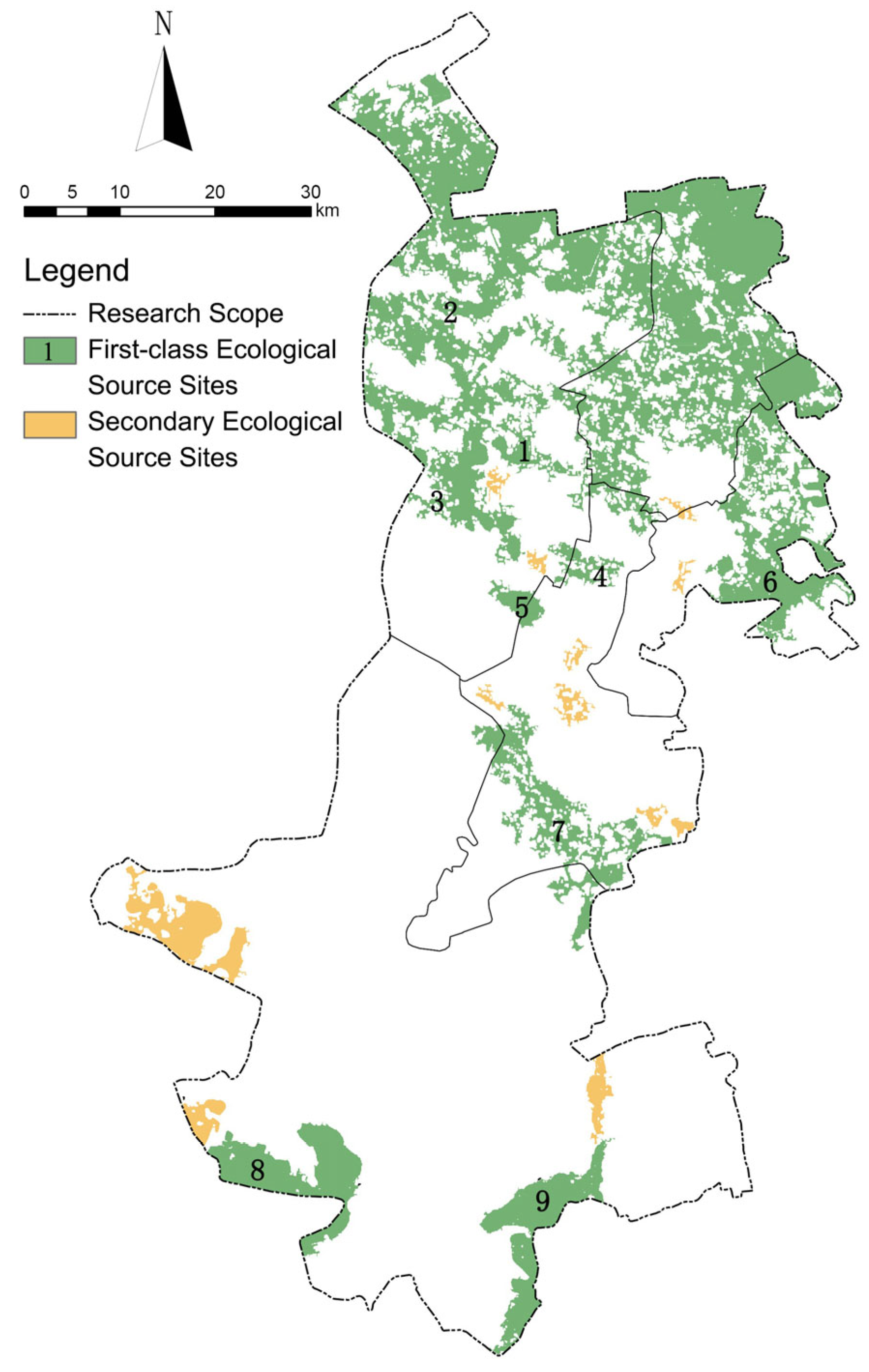
A threshold of dPC > 0.5 was chosen to identify patches with strong connectivity to surrounding landscape elements, indicative of their role in facilitating ecological flows and maintaining landscape integrity, leading to their identification as primary ecological source sites. Additionally, the size criterion of >1000 hm2 ensures the inclusion of patches large enough to support viable populations of species and maintain ecosystem functions, which is critical for their designation. As a result, nine patches were identified as primary ecological source sites. For secondary ecological source sites, patches with 0.1 < dPC < 0.5 were extracted and classified. This range was selected to recognize patches that, while not as connected or as large as primary sites, still play a vital role in the ecological network by acting as stepping stones or support areas, contributing to ecological connectivity and resilience, albeit to a lesser extent than primary sites. Consequently, 13 patches were classified as secondary ecological source sites. This methodological approach ensures a comprehensive evaluation of landscape connectivity, supporting the conservation of ecological diversity by maintaining critical core areas for species migration [3].
where n represents the total number of patches; are the area of the respective patch; refers to the maximum value of the product of the probability of all paths between patches i and j; is the total area of the landscape in the region; PC represents the probable connectivity index of a given patch in the landscape, where 0 ≤ PC ≤ 1; dPC stands for the importance of the patch; and represents the probable connectivity index after removing the patch.
2.3.2. Ecological Resistance System Construction
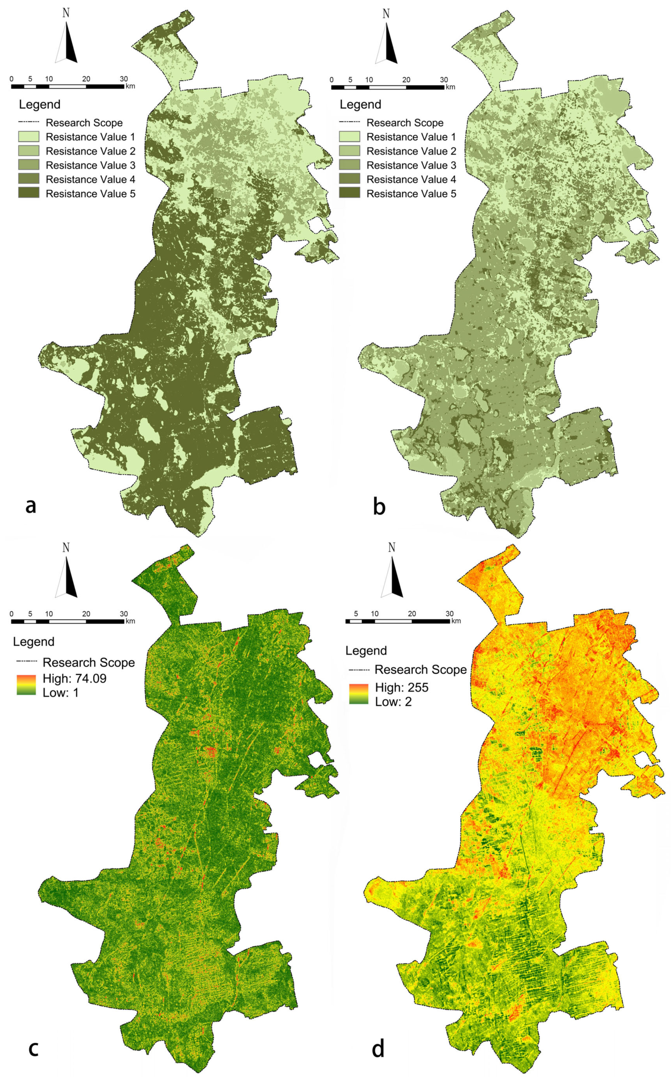
The concept of ecological resistance factors encompasses the landscape impediments encountered during species movement. This notion primarily focuses on barriers potentially impacting species distribution and mobility. Key geographical attributes, such as Morphological Spatial Pattern Analysis (MSPA) landscape types, land use, slope, and elevation, are instrumental in delineating regional characteristics, and these factors are commonly employed to outline fundamental aspects of ecological corridor construction. In alignment with prior academic findings [23,24], this study adopted a stratified assignment approach for evaluating resistance indices. Utilizing the Delphi method, each index was assigned a resistance value ranging from 1 to 5 (refer to Table 1). A lower score denotes diminished resistance and enhanced suitability for corridor establishment. This research study integrated four distinct ecological resistance layers, employing expert scoring to ascertain the weight coefficients of each layer (as shown in Table 1). Subsequently, individual resistance maps were generated for four categories: MSPA cost, land use cost [25], slope cost, and elevation cost [26,27]. Utilizing the weighted sum function in ArcGIS 10.2, these quantified indicators were amalgamated in accordance with their respective weights [28], culminating in a comprehensive cost map for the forest ecological corridor.
2.3.3. Extraction of Ecological Routing Based on MCR Modeling
The Minimum Cumulative Resistance model (MCR) is distinguished by its straightforward design and broad applicability, efficiently generating the shortest potential path by computing the cumulative resistance value between a source and a destination. Central to this process is the competitive diffusion from the source across adjacent spatial units within a resistance surface system. This approach effectively captures the dynamics of material and energy movement within a landscape, facilitating a deeper understanding of interactions among various patches [29,30]. The governing equation of the MCR model is presented below:
where represents the spatial distance from the source point j to the target point I; represents the resistance value at the target point i.
2.3.4. Open Space Resource Point Identification and Functional Evaluation System Construction
By organizing and analyzing both the collected basic information and the results of the on-site research, it is established that A-level tourist attractions that can provide leisure and vacation, recreation and fitness functions, parks and green areas with relatively complete and characteristic infrastructure, and natural resource points with an excellent ecological environment, such as scenic areas and nature reserves, ought to be used to determine the source of ecological corridor routing for recreational functions [2]. The road grade and rail and bus station service radius are selected as the evaluation indices of the recreational function, and recreational resistance and weighting coefficients are assigned (Table 2); then, the recreational cost resistance surface is produced.
Table 2.
Recreation resistance evaluation system.
2.3.5. Recreational Route Selection Extraction Based on GIS Network Analysis
The ArcGIS spatial module’s network analyst tool encapsulates a comprehensive suite of data elements, including centers, links, nodes, and impedance values. This tool is adept at delineating the most efficient routes within a road network, facilitated by target resource points that navigate in accordance with varying resistance values [31,32]. The formulation of the optimal pathway connecting source points is an intricate process that involves a sequential methodology: initially, the cost-influencing factors are analyzed; subsequently, a road raster resistance surface is established; following this, a network dataset is created; source locations are then incorporated; analysis options are meticulously set; the analysis procedure is executed; and, finally, the results of the analysis are displayed. This framework also categorizes the paths into three distinct types: the primary (critical) path, the secondary path, and the general path. Each differs in terms of their strategic importance and utility within the network analysis.
3. Results and Analysis
3.1. Identification of Source Lands and Extraction of Line Selection Based on Ecological Protection Perspectives
The comprehensive analysis, anchored in the robust data delineated in Table 3 and Table 4, Figure 3 and Figure 4, discloses that the core area spans approximately 165,470 hectares (hm2), accounting for 84.5% of the total designated ecological landscape and 32.77% of the overall study domain. This significant area is primarily located in the northern segment of Daqing City’s urban core. Here, the ecological patches are distinguished by their exceptional connectivity, weaving together to form a cohesive ecological matrix. In stark contrast, the southern part of the region is marked by a much more fragmented distribution of core patches, showcasing a palpable decrease in inter-patch connectivity and, thus, highlighting a critical area for targeted ecological restoration efforts.
Table 3.
Landscape type classification statistics.
Table 4.
Core area connectivity index ranking.

Figure 3.
MSPA analysis results.
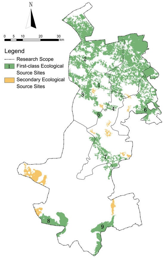
Figure 4.
Ecological source distribution.
The primary ecological source sites identified—patches 1, 2, and 6—are centrally positioned in the northern and central sections of the study area. These patches stand out due to their vast expanse and intact ecological fabric, acting as vital hubs for biological migration and interaction. Their strategic importance lies in bolstering the region’s ecological dynamics. Meanwhile, patches 3, 4, and 5, nestled at the heart of the ecological network, are instrumental in enhancing connectivity across the landscape, thereby facilitating the movement and diversity of species. On the periphery, source sites 7, 8, and 9, albeit more isolated, point to a significant opportunity for developing ecological corridors to bridge these gaps. The establishment of such corridors is essential for promoting species interchange, enriching biodiversity, and enhancing ecosystem resilience. Conversely, the secondary ecological source sites, characterized by a disturbance potential coefficient (0.1 < dPC < 0.5), play an indispensable role in the spatial ecology of the region. These sites act as a vital buffer, mitigating the disparities in the distribution of primary source sites and facilitating a strategic ecological balance. Located primarily in the south-central part of the city, these secondary sites are crucial for establishing a north–south ecological axis, thereby ensuring a more balanced distribution of ecological resources across the urban landscape.
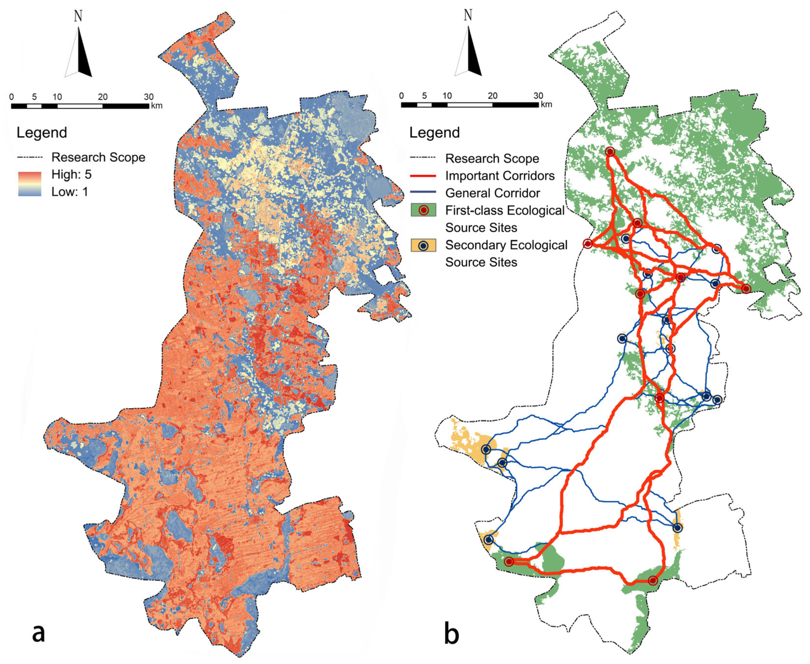
The methodology employed in this study integrates primary and secondary ecological source sites using a nuanced approach, leveraging the ecological single-factor cost map (illustrated in Figure 5) and the comprehensive ecological cost map (depicted in Figure 6a). Through a meticulous assessment using ArcGIS’s cost distance and cost path tools, potential ecological corridors were identified, providing a strategic framework for the development of forest ecological corridors. These corridors, categorized into ‘important’ and ‘general’ based on their origination from primary or secondary source sites, respectively, embody a dual-tiered network structure (as visualized in Figure 6b). The layout of important corridors is particularly strategic, extending southward and linking urban areas of high construction intensity. This not only enhances the ecological integrity of Daqing City’s urban core but also plays a pivotal role in connecting fragmented habitats, thereby augmenting the overall ecological value and fostering urban integration. The general corridors, forming the secondary layer of the network, complement the layout of important corridors by addressing spatial discontinuities. This tiered approach ensures a cohesive, hierarchical, and functionally diverse forest ecological corridor system, underpinning a sustainable urban ecological framework. This study underscores the imperative of a balanced ecological strategy, intertwining conservation efforts with urban development to achieve a resilient and vibrant ecological urban landscape.
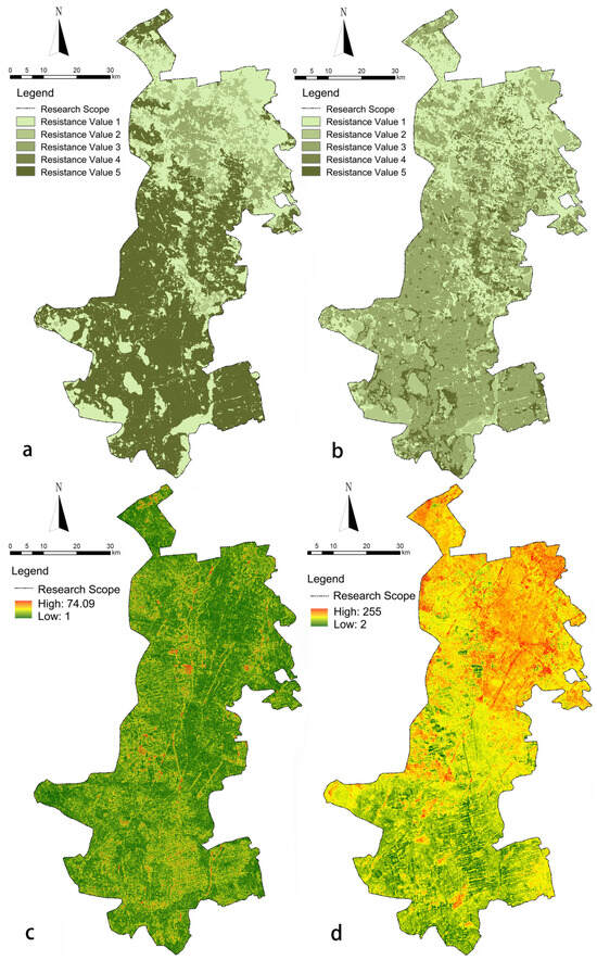
Figure 5.
Ecological single-factor cost: (a). MSPA cost; (b). land use cost; (c). slope cost; (d). altitude cost.
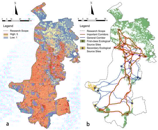
Figure 6.
Corridor ecological function model. (a). Ecological integration cost. (b). Ecological potential corridor.
3.2. Resource Identification and Line Selection Extraction Based on Recreational Perspective
This study, referencing the regional cooperation development research in tourism conducted by the Daqing Tourism Bureau [12], highlights Daqing’s distinctive cultural and natural attributes. Daqing is internationally recognized for its rich oil culture and as the birthplace of the esteemed “Iron Man” spirit. The city’s diverse and extensive wetland areas, coupled with its abundant geothermal reserves, create ideal conditions for hot springs and recuperative tourism. Daqing boasts a significant number of tourist attractions, including 12 4A-rated and 11 3A-rated scenic spots, alongside 9 industrial and agricultural tourism demonstration sites (Figure 7). The proposed forest ecological corridor represents a strategic implementation of ecological value-led planning, which aligns with the overarching theme of ecological construction in resource-dependent cities like Daqing. It seeks to inspire citizens to interact more deeply with the city’s natural and cultural resources, fostering an ethos of low-carbon travel. Consequently, the recreational route construction cost analysis incorporates considerations for enhancing the ecological network and integrating with the public transportation system to promote a sustainable, low-carbon tourism model. In the realm of road categorization, the urban expressways and highways, despite providing extensive urban, long-distance, and rapid transportation services, rank lower in terms of carbon efficiency. In contrast, urban arterial roads, which serve as key connectors across various urban districts and primarily facilitate traffic distribution, are identified to have a moderate level of carbon efficiency. Urban secondary roads, crucial for linking different infrastructure segments and accommodating daily traffic and leisure activities, are highlighted as epitomizing the highest level of carbon efficiency and decarbonization potential. In the context of Daqing City’s rail transit line network planning, noteworthy developments include the planned interchange points at Yuanwang and Sanyong Lake for the first phase of Line 1, and at Sanyong Lake and the Saltu District Government for the first phase of Line 3. Additionally, the envisioned R3 line is set to extend through Sada Road to Datong Town. Due to the current lack of detailed planning for Daqing City’s rail transit network, these interchange points are provisionally considered evaluation hubs. The locations of bus stops and passenger terminals were ascertained through analysis of the city’s point of interest (POI) big data.
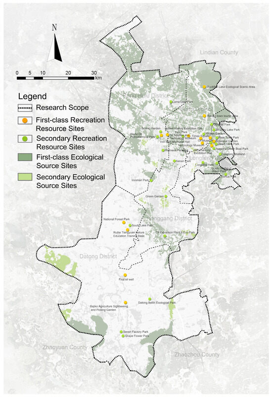
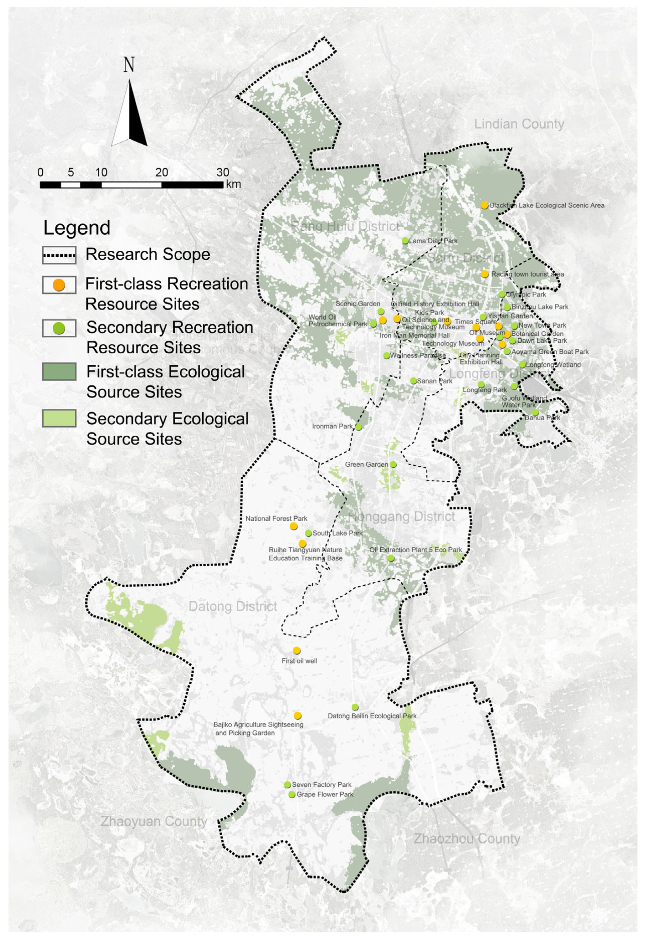
Figure 7.
Distribution of recreation resource sites.
In the main city of Daqing, A-level scenic spots, such as the Tieren Memorial Hall, Oilfield History Exhibition Hall, and Times Square, are identified as key resources, epitomizing the city’s brand and cultural essence. Concurrently, ecologically significant sites such as the National Forest Park and Bajizi Agricultural Sightseeing and Picking Park are acknowledged as primary recreational resource points. Additionally, urban parks and green spaces, serving as critical spatial carriers for “ecology and recreation”, play an irreplaceable role in the urban landscape. Following an extensive network data search and field research, park nodes of high resource value and public satisfaction, such as Lamaideen Park, Jingyuan Park, Tieren Park, Longfeng Park, and Datong Beilin Ecological Park, were selected as secondary recreational points. These selections were informed by the recreation cost resistance surface, forming the basis for the recreation model of the forest ecological corridor in the study area (Figure 8). The analysis reveals a relatively balanced distribution of primary and secondary resource points, although with a noted concentration in the north-eastern part of the densely urbanized area, suggesting the need for a strategic focus on the equitable distribution of recreational and ecological resources. The structured layout of recreational routes, organized into three tiers, provides a coherent and effective framework for connecting recreational resource points through low-carbon transportation options. This study demonstrates a synergistic relationship between the forest ecological corridors and urban transportation systems, enhancing the accessibility of public transport for citizens and contributing to a reduction in carbon emissions from private vehicles. This integrated approach not only supports the control of carbon emissions but also serves as a functional blueprint for the ecologically oriented composite forest ecological corridor, thereby enriching recreational activities and promoting sustainable urban development. This in-depth analysis further elaborates on the critical role of strategic planning in achieving a balanced integration of recreational resources and ecological considerations, paving the way for a more sustainable, low-carbon future for cities like Daqing.
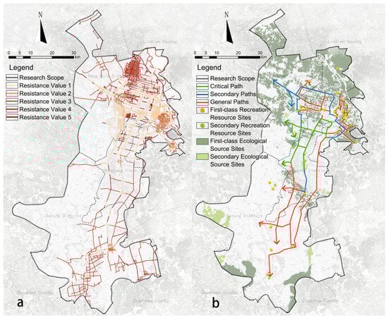
Figure 8.
Forest ecological corridor recreation function model: (a). combined cost of recreation; (b). potential pathways for recreation.
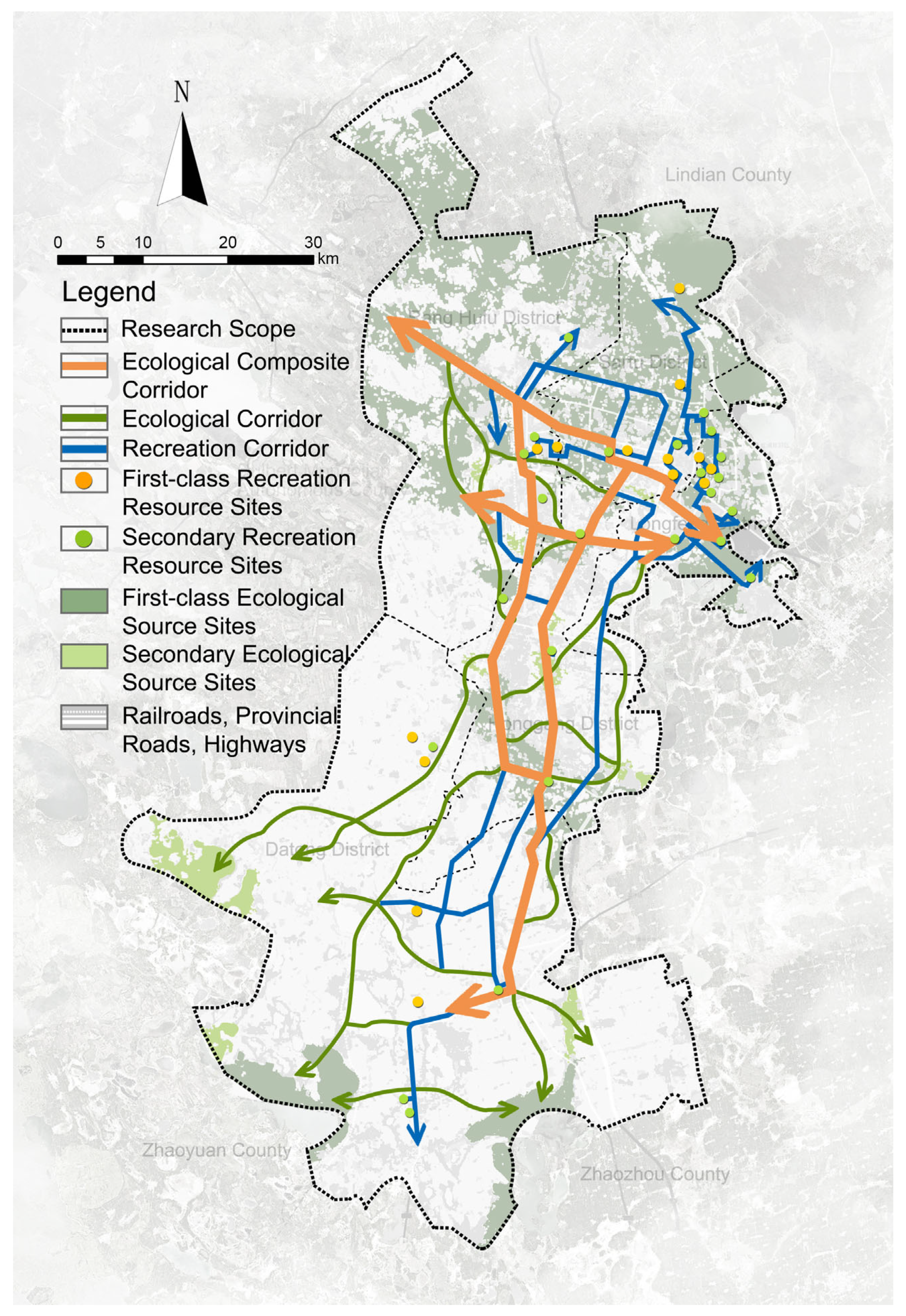
3.3. Construction of Composite Forest Ecological Corridors
Addressing the ecological challenges inherent in resource cities and fostering urban transformation and development, this study presents an analysis of the ecological and recreational resources of Daqing City. This analysis is conducted from a dual perspective of “ecologyrecreation”, spatially coupling and integrating the selection of both ecological and recreational corridors. The selection of ecological routes is prioritized, forming the basis of a composite forest ecological corridor and is then complemented by recreational route selection. This composite approach necessitates a reclassification and integration of the source and selection lines, leading to an optimized arrangement of resource points and network layouts, which are specifically categorized into three types: ecological composite corridors, ecological corridors, and recreational corridors. Ecological composite corridors, embodying the concept of multifunctional green infrastructure, are designed to serve multiple purposes, including habitat conservation, recreation, stormwater management, and climate adaptation. This multifunctionality underlines the capacity of ecological composite corridors to meet the specific needs and constraints of both densely constructed urban areas and less-developed regions. By offering significant environmental and social values to urban residents, ecological composite corridors stand as pivotal links between ecological and recreational functionalities.
The overall layout of the forest ecological corridors in the main urban area of Daqing City reveals a distinct pattern: high-density construction areas predominantly feature recreational corridors, whereas less-developed areas are primarily characterized by ecological corridors. The ecological composite corridors function as the pivotal link between these two characteristics (Figure 9) [5]. In the northern part of Daqing City’s main urban area, an ecologically superior zone is identified, characterized by its exceptional service functions and environmental values. This zone, functioning as an independent source patch, warrants a preservation-focused approach. Consequently, the construction of additional artificial corridors in this area is discouraged in order to maintain its pristine original environment. In the city’s high-density areas, which are rich in recreational resources such as oil culture landmarks, the development of recreational corridors is advised. This initiative should hinge on a thorough evaluation of the potential of these roads to contribute to the city’s low-carbon goals, ensuring that the enhancement of recreational access does not come at the expense of environmental sustainability. In the southern sector of Daqing, characterized by its fragmented ecological patches, the focus shifts towards the creation of ecological corridors. These corridors aim to bridge the gaps between isolated ecological patches and natural landscape nodes, enhancing ecological continuity and connectivity. This strategy is critical in mitigating the effects of urbanization on natural habitats, promoting biodiversity and facilitating the movement of wildlife across the urban landscape. The unique narrow and elongated urban distribution of Daqing’s main city imposes limitations on achieving a closed layout for forest ecological corridors. Nonetheless, this spatial characteristic presents opportunities for tailoring the development and construction of corridor functions to local conditions. Embracing the concept of “ecological dominance with coordinated recreational function”, this approach seeks to maximize the ecological regulation and social service functions of the corridors and is instrumental in fostering a more compact and cohesive urban layout pattern:

Figure 9.
Complex forest ecological corridor network spatial structure.
(1) The ecological composite corridors are strategically located along the east–west arterial roads, such as Zhongsan Road and Nansan Road, which traverse the city’s densely constructed areas. Additionally, Sada Road, pivotal in connecting the city’s north–south layout, contributes to a well-orchestrated layout. These corridors form the backbone of the forest ecological corridor network, offering significant ecological value. They are designed to enhance ecological connectivity, biodiversity conservation, and the provision of ecosystem services, including flood prevention and urban heat island mitigation, thereby facilitating daily commuting for residents and acting as primary conduits for long-distance recreational activities. The overlapping of these corridors does not imply redundancy but rather an integration of functions that enhances both ecological integrity and human well-being.
(2) Eco-corridors, functioning as extensions of the ecological composite network, play a vital role in linking various ecological sources. Predominantly situated in the southern part of the city where development intensity is comparatively lower, these corridors are designed with consideration of topographical features and slope, among other fundamental resistance factors. This approach is part of establishing new composite corridors in place of existing ones to augment the existing green infrastructure by adding value through enhanced biodiversity, improved environmental quality, and increased green space. The resulting network structure of ecological corridors, characterized by its streamlined layout and pronounced sense of extension, is instrumental in facilitating gene exchange and migration for various species, serving multiple functions, enhancing species diversity and landscape connectivity, promoting ecological conservation, and acting as a buffer against urban sprawl, while also incorporating elements of ecological preservation alongside providing recreational spaces for human enjoyment.
(3) Recreational corridors, strategically reliant on existing road layouts and transportation hubs, serve to connect A-level scenic spots and green park nodes. These corridors are primarily situated in high-density urban areas, which are rich in cultural and natural recreational nodes, and extend into the southern parts of the city, where the development intensity is lower and the network structure is less dense, thereby fulfilling a complementary role. Leveraging and optimizing existing resources, this approach creates a more comprehensive and multifunctional green network, enriching both the urban ecological framework and the quality of human life. These corridors are seamlessly integrated with urban roads, exhibiting an orderly layout. They play a crucial role in connecting and enhancing the city’s humanistic recreational value while simultaneously protecting and promoting its cultural heritage and incorporating elements of ecological preservation.
4. Discussion
An in-depth analysis of the developmental trajectory and current state of resource cities was conducted to identify the principal conflicts and pressing issues that necessitate resolution, particularly in the realm of corridor construction. This study advocates for a dual-focused approach, firstly by emphasizing the nature protection function to counteract regional ecological fragmentation, and, secondly, by implementing a composite strategy that integrates leisure and recreational functions. This dual approach forms the foundational framework for forest ecological corridor planning in resource cities. This framework is anchored in a comprehensive and pragmatic blueprint for corridor development, encompassing detailed design plans, a phased implementation strategy. This expanded methodology and framework not only address the critiques but also further delineate the practical blueprint for the construction and implementation of composite humanistic forest ecological corridors, thereby reinforcing their role in sustainable urban development and the integration of ecological and humanistic values in city planning.
(1) To enhance the identification of “ecological-open space” source areas, we refined the subjective selection process of resource elements. Utilizing the Morphological Spatial Pattern Analysis (MSPA) method, we examined ecological source area patches at two distinct levels. This involved assessing the significance of these patches in preserving landscape connectivity, with a particular emphasis on their role in connectivity [33]. The categorization of two tiers of recreational resource spots was achieved through the amalgamation of extensive big data sourced from online platforms and was complemented by empirical field research. This approach was directed toward emphasizing humanistic values and service functionalities [34]. The corridor patches, identified at both levels, serve to mutually enhance and enrich one another, thereby fostering an integrated approach that aligns the multifaceted benefits of both ecological and societal values.
(2) In selecting the “ecological-recreational” corridors, the methodologically derived source patches offer a robust foundation for identifying potential corridors. This process is facilitated using a Geographic Information System (GIS) platform, employing the Minimum Cumulative Resistance (MCR) model. Such an approach ensures the seamless integration of Morphological Spatial Pattern Analysis (MSPA), landscape connectivity analysis, and minimum path analysis [35]. Concurrently, the utilization of ArcGIS network analysis lends vital scientific support to the selection of recreational routes [36]. Both methods are underpinned by the ecological resistance system and road resistance system, with the generated potential routes providing insightful guidance for the layout of the corridor network.
(3) In developing the “ecological-recreational” composite ecological corridor, the focus extends beyond mere natural ecology to a holistic approach that prioritizes ecological considerations while simultaneously coordinating human–nature interaction and balancing development with protection [37]. The forest corridor, as a pivotal element of urban green infrastructure, plays a critical role in achieving sustainable urban development, optimizing the spatial pattern by leveraging its habitat and service functions. The methodology involves selecting resource points and lines across the dual dimensions of “ecology and recreation”, which are then synergistically integrated with the urban context. This strategy addresses the prevalent issues in urban development, characterized by uneven distribution, fragmentation, and the underdevelopment of humanistic values and recreational functions. By integrating and connecting natural, humanistic, and recreational resources, the approach enhances the functions and values of the forest ecological corridors, which not only enriches the urban landscape but also serves as a model for the construction of humanistic and composite forest ecological corridors in resource-oriented cities.
In the realm of research methodologies, several aspects warrant further exploration. A notable issue is the sensitivity of Morphological Spatial Pattern Analysis (MSPA) to the scale of study. Variations in granularity and edge width significantly influence the outcomes of the analysis [38,39]. Furthermore, different distance thresholds and connectivity probabilities impact the values of the delta Integral Index of Connectivity (dIIC) and the probability of connectivity (PC), necessitating a more detailed investigation into the appropriate scale for MSPA [40]. Another critical aspect is the determination of landscape resistance values and the development of landscape resistance surfaces [41]. Due to the scarcity of comprehensive ecological data in the study area, the ecological network was not specifically tailored to the life characteristics of a particular species. The appropriateness of the chosen landscape resistance layers and their assigned values needs further scrutiny. Additionally, it is essential to align the research with the specific context and developmental trajectory of Daqing City. The width and construction sequence of forest ecological corridors should be tailored to local conditions, taking into account the unique environmental and developmental factors of the area.
5. Conclusions
Forest ecological corridors, as vital components of urban green infrastructure, play a crucial role in fostering urban compactness and integrated energy utilization [42]. However, the planning definition of these corridors becomes complex and somewhat nebulous when they encompass both ecological protection and recreational usage for residents. The singular designation of these corridors as solely ecological or recreational is insufficient for capturing their multifaceted purpose in optimizing the ecological environment and enhancing leisure. International research has delved into the concept of multi-objective corridor planning [43,44]. These studies predominantly focus on the functional differentiation within the corridors themselves; however, for resource-based cities, issues such as spatial layout unevenness and ecological fragmentation significantly impede ecological restoration and urban rehabilitation [45]. In this context, the ecological significance of forest corridors in the urban network layout is paramount. Concurrently, the exploration of the city’s resource endowments, the perpetuation of its cultural spirit, and the realization of its potential advantages should not be overlooked [12]. Integrating these ecological and recreational corridors into the urban fabric of Daqing not only serves ecological and recreational purposes but also acts as a strategic lever for urban regeneration. The implementation of these corridors can stimulate economic development in adjacent areas, encourage sustainable tourism, and enhance the overall quality of life for the city’s residents. Moreover, this strategy aligns with global trends towards sustainable urban development, positioning Daqing as a model city that harmonizes urban expansion with ecological sustainability. Our study aims to introduce a research approach and methodological framework by analyzing a particular city as a case study. We seek not only to offer solutions and recommendations for specific types of cities but also to provide a universally adaptable method for researchers and urban planners. We encourage the application of these methods in various urban contexts for tailored development goals and challenges.
Author Contributions
Conceptualization, Z.J. and P.C.; methodology, Z.J. and P.C.; software, Z.J.; formal analysis, Z.J.; investigation, Z.J.; resources, Z.J. and P.C.; data curation, Z.J.; writing—original draft preparation, Z.J.; writing—review and editing, Z.J.; visualization, Z.J.; supervision, P.C.; project administration, P.C.; funding acquisition, P.C. All authors have read and agreed to the published version of the manuscript.
Funding
This work was supported by the Fundamental Research Funds for the Central Universities (2572022BK02, 2572018CP06).
Institutional Review Board Statement
Not applicable.
Informed Consent Statement
Not applicable.
Data Availability Statement
The data presented in this study are available upon request from the corresponding author.
Acknowledgments
We would like to thank all the partners involved in this study and the experimental platform provided by Northeast Forestry University. The authors are also grateful to the journal’s editors and anonymous reviewers for their helpful comments.
Conflicts of Interest
The authors declare no conflict of interest.
References
- Zhou, Q.; Konijnendijk van den Bosch, C.C.; Chen, J.; Zhang, W.; Dong, J. Identification of ecological networks and nodes in Fujian province based on green and blue corridors. Sci. Rep. 2021, 11, 20872. [Google Scholar] [CrossRef] [PubMed]
- Hong, T.; Li, L.; Wang, B. The Planning and Construction Path of Innovative and Intelligent Park Cities Based on Big Data Technology. Math. Probl. Eng. 2022, 2022, 6049677. [Google Scholar] [CrossRef]
- Xu, X.; Wang, S.; Rong, W. Construction of ecological network in Suzhou based on the PLUS and MSPA models. Ecol. Indic. 2023, 154, 110740. [Google Scholar] [CrossRef]
- Lei, Q.; Lau, S.S.Y.; Fan, Y.; Fu, I.C.S.; Chan, J.T.Y.; Tao, Y.; Zhang, L.; Lai, H.; Miao, Y.; Qi, Y. From Policy to Implementation—An Analytic Network Process (ANP)-Based Assessment Tool for Low Carbon Urban and Neighborhood Planning. Buildings 2023, 13, 484. [Google Scholar] [CrossRef]
- Jiang, X.; Zhao, T. Research on the Spatial Structure of County Greenway Network Based on Gravitation-Resistance Measurement—A Case Study of Ning’an in China. Sustainability 2020, 12, 1352. [Google Scholar] [CrossRef]
- Yang, C.; Guo, H.; Huang, X.; Wang, Y.; Li, X.; Cui, X. Ecological Network Construction of a National Park Based on MSPA and MCR Models: An Example of the Proposed National Parks of “Ailaoshan-Wuliangshan” in China. Land 2022, 11, 1913. [Google Scholar] [CrossRef]
- Xue, W. Construction of Low Carbon City Economic Security Management System Based on BP Artificial Neural Network. Sustain. Energy Technol. Assess. 2022, 53, 102699. [Google Scholar] [CrossRef]
- Hou, L.; Wu, F.; Xie, X. The Spatial Characteristics and Relationships Between Landscape Pattern and Ecosystem Service Value Along an Urban-Rural Gradient in Xi’an City, China. Ecol. Indic. 2020, 108, 105720. [Google Scholar] [CrossRef]
- Wu, X.; Zhang, J.; Geng, X.; Wang, T.; Wang, K.; Liu, S. Increasing Green Infrastructure-Based Ecological Resilience in Urban Systems: A Perspective from Locating Ecological and Disturbance Sources in a Resource-Based City. Sustain. Cities Soc. 2020, 61, 102354. [Google Scholar] [CrossRef]
- Ntshanga, N.K.; Procheş, S.; Slingsby, J.A. Assessing the Threat of Landscape Transformation and Habitat Fragmentation in a Global Biodiversity Hotspot. Austral Ecol. 2021, 46, 1052–1069. [Google Scholar] [CrossRef]
- Xiong, G.; Cao, X.; Hamm NA, S.; Lin, T.; Zhang, G.; Chen, B. Unbalanced Development Characteristics and Driving Mechanisms of Regional Urban Spatial Form: A Case Study of Jiangsu Province, China. Sustainability 2021, 13, 3121. [Google Scholar] [CrossRef]
- Van Oijstaeijen, W.; Van Passel, S.; Cools, J. Urban Green Infrastructure: A Review on Valuation Toolkits from an Urban Planning Perspective. J. Environ. Manag. 2020, 267, 110603. [Google Scholar] [CrossRef] [PubMed]
- Daqing City Tourism Bureau. Study on the Development of Regional Cooperation in Tourism in Daqing City. Daqing Soc. Sci. 2017, 5, 5–7. [Google Scholar]
- GB/T 21010-2017; Classification of Current Land Use Situations. National Standards of the People’s Republic of China: Beijing, China, 2017.
- Le, V.N.T.; Ahderom, S.; Apopei, B.; Alameh, K. A Novel Method for Detecting Morphologically Similar Crops and Weeds Based on the Combination of Contour Masks and Filtered Local Binary Pattern Operators. GigaScience 2020, 9, giaa017. [Google Scholar] [CrossRef] [PubMed]
- Fu, Y.; Shi, X.; He, J.; Yuan, Y.; Qu, L. Identification and Optimization Strategy of County Ecological Security Pattern: A Case Study in the Loess Plateau, China. Ecol. Indic. 2020, 112, 106030. [Google Scholar] [CrossRef]
- Shi, F.; Liu, S.; An, Y.; Sun, Y.; Zhao, S.; Liu, Y.; Li, M. Spatio-Temporal Dynamics of Landscape Connectivity and Ecological Network Construction in Long Yangxia Basin at the Upper Yellow River. Land 2020, 9, 265. [Google Scholar] [CrossRef]
- Funk, A.; Baldan, D.; Bondar-Kunze, E.; Recinos Brizuela, S.; Kowal, J.; Hein, T. Connectivity as a Driver of River-Floodplain Functioning: A Dynamic, Graph Theoretic Approach. Ecol. Indic. 2023, 154, 110877. [Google Scholar] [CrossRef]
- Wang, S.; Wu, M.; Hu, M.; Chen, F.; Wang, T.; Xia, B. Promoting Landscape Connectivity of Highly Urbanized Area: An Ecological Network Approach. Ecol. Indic. 2021, 125, 107487. [Google Scholar] [CrossRef]
- Reza MI, H.; Rafaai, N.H.; Abdullah, S.A. Application of Graph-Based Indices to Map and Develop a Connectivity Importance Index for Large Mammal Conservation in a Tropical Region: A Case Study in Selangor State, Peninsular Malaysia. Ecol. Indic. 2022, 140, 109008. [Google Scholar] [CrossRef]
- Tang, Q.; Li, J.; Tang, T.; Liao, P.; Wang, D. Construction of a Forest Ecological Network Based on the Forest Ecological Suitability Index and the Morphological Spatial Pattern Method: A Case Study of Jindong Forest Farm in Hunan Province. Sustainability 2022, 14, 3082. [Google Scholar] [CrossRef]
- Li, Y.Y.; Zhang, Y.Z.; Jiang, Z.Y.; Guo, C.-X.; Zhao, M.-Y.; Yang, Z.-G.; Guo, M.-Y.; Wu, B.-Y.; Chen, Q.-L. Integrating Morphological Spatial Pattern Analysis and the Minimal Cumulative Resistance Model to Optimize Urban Ecological Networks: A Case Study in Shenzhen City, China. Ecol. Process. 2021, 10, 63. [Google Scholar] [CrossRef]
- Fei, W.; Zhao, M. Construction of Nanjing Green Infrastructure Network Based on MSPA. J. Nanjing For. Univ. 2022, 46, 50. [Google Scholar] [CrossRef]
- Cui, L.; Wang, J.; Sun, L.; Lv, C. Construction and Optimization of Green Space Ecological Networks in Urban Fringe Areas: A Case Study with the Urban Fringe Area of Tongzhou District in Beijing. J. Clean. Prod. 2020, 276, 124266. [Google Scholar] [CrossRef]
- Wang, Z.; Shi, Z.; Huo, J.; Zhu, W.; Yan, Y.; Ding, N. Construction and Optimization of an Ecological Network in Funiu Mountain Area Based on MSPA and MCR Models, China. Land 2023, 12, 1529. [Google Scholar] [CrossRef]
- Yi, D.; Guo, X.; Han, Y.; Guo, J.; Ou, M.; Zhao, X. Coupling Ecological Security Pattern Establishment and Construction Land Expansion Simulation for Urban Growth Boundary Delineation: Framework and Application. Land 2022, 11, 359. [Google Scholar] [CrossRef]
- Xu, W.; Wang, J.; Zhang, M.; Li, S. Construction of Landscape Ecological Network Based on Landscape Ecological Risk Assessment in a Large-Scale Opencast Coal Mine Area. J. Clean. Prod. 2021, 286, 125523. [Google Scholar] [CrossRef]
- Mei, Y.; Sun, Y.; Wang, Q.; Liu, Q.; Zhang, L. Construction of Green Space Ecological Network in Jinan City Based on MSPA and MCR Model. Pol. J. Environ. Stud. 2022, 31, 3701–3711. [Google Scholar] [CrossRef]
- Huang, R.; Nie, Y.; Duo, L.; Zhang, X.; Wu, Z.; Xiong, J. Construction Land Suitability Assessment in Rapid Urbanizing Cities for Promoting the Implementation of United Nations Sustainable Development Goals: A Case Study of Nanchang, China. Environ. Sci. Pollut. Res. 2021, 28, 25650–25663. [Google Scholar] [CrossRef] [PubMed]
- Yang, Z.; Ma, C.; Liu, Y.; Zhao, H.; Hua, Y.; Ou, S.; Fan, X. Provincial-Scale Research on the Eco-Security Structure in the Form of an Ecological Network of the Upper Yellow River: A Case Study of the Ningxia Hui Autonomous Region. Land 2023, 12, 1341. [Google Scholar] [CrossRef]
- Wu, W.; Wang, Y. Evaluation and Promotion of the Service Capacity of Urban Public Open Spaces Based on Improving Accessibility: A Case Study of Shenyang City, China. Chin. Geogr. Sci. 2021, 31, 1045–1056. [Google Scholar] [CrossRef]
- Xiao, H.; Guo, Y.; Wang, Y.; Xu, Y.; Liu, D. Evaluation and Construction of Regional Ecological Network Based on Multi-Objective Optimization: A Perspective of Mountains–Rivers–Forests–Farmlands–Lakes–Grasslands Life Community Concept in China. Appl. Sci. 2022, 12, 9600. [Google Scholar] [CrossRef]
- Wang, L.; Zhai, Y.L.; Jia, J.; Lu, Y.; Yao, M.C.; Zhang, L.X.; Ning, J.; Yao, Y.L. Ecological Cooling Demand in Changchun City of China: Spatial Response to Differences in Urban Thermal Environment Intensity. Appl. Ecol. Environ. Res. 2023, 21, 1711–1729. [Google Scholar] [CrossRef]
- Xiao, Z.; Zhao, D.; Hao, L. Analysis of Green Infrastructure Network Pattern Change in Zhengzhou Central City Based on Morphological Spatial Pattern Analysis. Earth Sci. Res. J. 2023, 27, 289–297. [Google Scholar] [CrossRef]
- Mell, I.; Clement, S. Progressing green infrastructure planning: Understanding its scalar, temporal, geo-spatial and disciplinary evolution. Impact Assess. Proj. Apprais. 2020, 38, 449–463. [Google Scholar] [CrossRef]
- Chen, N.N.; Kang, S.Z.; Zhao, Y.H.; Zhou, Y.J.; Yan, J.; Lu, Y.R. Construction of ecological network in Qinling Mountains of Shaanxi, China based on MSPA and MCR model. J. Appl. Ecol. 2021, 32, 1545–1553. [Google Scholar] [CrossRef]
- Xia, M.; Wang, L.; Wen, B.; Zou, W.; Ou, W.; Qu, Z. Land Consolidation Zoning in Coastal Tidal Areas Based on Landscape Security Pattern: A Case Study of Dafeng District, Yancheng, Jiangsu Province, China. Land 2021, 10, 145. [Google Scholar] [CrossRef]
- Clemente, M. Rethinking “Streetline Forestscapes” in a Broader Context of Urban Forestry: In-Between Ecological Services and Landscape Design, with Some Evidence from Rome, Italy. Sustainability 2023, 15, 3435. [Google Scholar] [CrossRef]
- Yang, R.; Bai, Z.; Shi, Z. Linking morphological spatial pattern analysis and circuit theory to identify ecological security pattern in the Loess Plateau: Taking Shuozhou city as an example. Land 2021, 10, 907. [Google Scholar] [CrossRef]
- Li, P.; Gao, J.; Chen, J. Quantitative assessment of ecological stress of construction lands by quantity and location: Case study in Southern Jiangsu, Eastern China. Environ. Dev. Sustain. 2020, 22, 1559–1578. [Google Scholar] [CrossRef]
- Huang, X.; Wang, H.; Shan, L.; Xiao, F. Constructing and optimizing urban ecological network in the context of rapid urbanization for improving landscape connectivity. Ecol. Indic. 2021, 132, 108319. [Google Scholar] [CrossRef]
- Ustaoglu, E.; Sisman, S.; Aydınoglu, A.C. Determining agricultural suitable land in peri-urban geography using GIS and Multi Criteria Decision Analysis (MCDA) techniques. Ecol. Model. 2021, 455, 109610. [Google Scholar] [CrossRef]
- Ahern, J. Greenways as a Planning Strategy. Landsc. Urban Plan. 1995, 33, 131–155. [Google Scholar] [CrossRef]
- Liu, Z.; Lin, Y.; De Meulder, B.; Wang, S. Heterogeneous Landscapes of Urban Greenways in Shenzhen: Traffic Impact, Corridor Width and Land Use. Urban For. Urban Green. 2020, 55, 126785. [Google Scholar] [CrossRef]
- Yang, J.; Chen, F.; Wang, Y.; Mao, J.; Wang, D. Performance evaluation of ecological transformation of mineral resource-based cities: From the perspective of stage division. Ecol. Indic. 2023, 154, 110540. [Google Scholar] [CrossRef]

Disclaimer/Publisher’s Note: The statements, opinions and data contained in all publications are solely those of the individual author(s) and contributor(s) and not of MDPI and/or the editor(s). MDPI and/or the editor(s) disclaim responsibility for any injury to people or property resulting from any ideas, methods, instructions or products referred to in the content. |
© 2024 by the authors. Licensee MDPI, Basel, Switzerland. This article is an open access article distributed under the terms and conditions of the Creative Commons Attribution (CC BY) license (https://creativecommons.org/licenses/by/4.0/).