Abstract
This paper analyzes the spatiotemporal evolution of a complex landslide risk scenario in a Latin American megacity, underscoring the key challenges it poses for sustainable urban planning in such cities. This research draws upon multiple studies commissioned by the mayor’s office of the megacity of Bogota, Colombia, and utilizes aerial photographs and satellite imagery from diverse sensor types. The methodology used considered six spatiotemporal analysis scenarios: rural/natural, mining, urban, landslide risk, stabilization and environmental park, and informal reoccupation. The findings reveal a complex interplay between the megacity’s peripheral areas, which face constraints for human settlement, and their potential for construction material exploitation. This complex relationship was further compounded by weaknesses in planning and controlling peripheral occupations, coupled with a burgeoning demand for developable land in a landslide risk context (landslide area: 73 ha). The analysis scenarios highlighted the predominant use of a reactive urban planning approach that addressed events, changes, or problems after they had occurred, rather than proactively anticipating and preventing potential risks at the study site. The detected land-use transformations unveiled different historical moments, culminating in a landslide disaster (804 houses destroyed, 3000 families at risk). This catastrophe necessitated a radical and significant intervention, incurring substantial costs for the megacity administration (USD 26.05 million). This landslide was the largest recorded in the megacity and one of the most extensive in urban areas across Latin America.
1. Introduction
The role of urban planning is to contribute to the objectives of equity, efficiency, and environmentally sound outcomes, fostering adequate hazard control and risk management [1,2]. It serves as an action framework for managers to influence the territory and build cities that promote collective well-being [3,4]. However, some urban actions face the challenge of overcoming conditions related to risk scenarios [5,6]. In the case of the megacity of Bogota, Colombia, various approaches have been implemented for urban planning without considering a comprehensive long-term vision. Ramírez [7] noted that in the late 1940s, physical planning, urban design, and the systemic approach embodied in documents such as ‘Le Corbusier’s Pilot Plan’ and ‘Regulatory Plan’ influenced urban planning in the megacity.
Urban physical planning was a process aimed at organizing and managing the development of urban areas in an efficient and sustainable manner [8]. It focused on the layout and distribution of a city’s physical elements, such as buildings, streets, parks, public services, and green areas, with the objective of creating functional, aesthetic, safe urban environments that improved residents’ quality of life [9]. Conversely, urban design was a multidisciplinary process that centered on the organization and physical configuration of urban areas to create functional, aesthetic, and sustainable environments [10,11]. Meanwhile, the systems approach to urban planning applied systems theory to understand and address the complexity of cities and urban environments [12]. It recognized cities as complex, dynamic systems composed of interrelated elements that influenced each other, and sought to understand these interconnections to address urban problems holistically [12].
Additionally, ‘Le Corbusier’s Pilot Plan’ and ‘Regulatory Plan’ considered the theory of human functions, master plans, neighborhood units theory, and urban zoning ordinances [13]. The theory of human functions aimed to design and organize urban environments based on the daily needs and activities of residents [14,15]. Master plans were detailed, strategic documents that established the vision, objectives, policies, and guidelines for the future development of a given urban area, often covering an extended time horizon and significantly influencing a community’s growth and evolution [16]. The neighborhood unit theory proposed organizing urban development into smaller, self-contained units with a mix of land uses and services, allowing residents to meet many of their daily needs within their own neighborhood [17,18]. Lastly, urban zoning ordinances were regulations established by local authorities that defined and regulated land use and development within a specific jurisdiction, with the main objective of controlling land use to promote coherent, equitable, and efficient urban development [19,20].
In the 1950s, the integral paradigm emerged in Bogota as a response to the evident limitations of previous urban planning approaches, amid internal crises within the guilds and sectors responsible for guiding urban planning in a city undergoing accelerated growth [7]. The integrated approach to urban planning was based on a comprehensive framework that addressed the complexity and interconnectedness of the different aspects that make up an urban environment [21,22]. It recognized cities as complex systems with numerous interrelated elements and sought to overcome sectoral or fragmented approaches by addressing urban challenges holistically [22]. Integrated urban planning, which emerged in the U.S.A., was conceived as a way of physically arranging a territory to achieve sustainable development objectives [23].
According to Mukhopadhyay and Faludi [24], current urban planning in the study megacity was based on substantive and procedural approaches. The substantive approach referred to the values and ethical principles of a society [22], while the procedural approach pertained to the specific needs and procedures of urban planning [25]. Ramírez [7] stated that three types of urban planning approaches have predominated in Colombia: technical/methodological/procedural, reactive of a substantive nature, and sociotechnical. Each of these approaches has left a mark on the megacity’s urban planning. The technical, methodological, and procedural approach to urban planning involved the application of specific methods, processes, techniques, and tools to carry out effective planning in a systematic and organized manner [26,27]. The reactive approach, on the other hand, responded to events, changes, or problems that had already occurred, rather than adopting a proactive perspective that anticipated and prevented potential urban challenges [28,29]. Lastly, the socio-technical approach recognized the interrelationship between social and technological aspects in the development and design of urban environments, seeking to integrate these dimensions to address urban challenges comprehensively and effectively [30,31].
Regarding risk scenarios in urban areas, Hungr et al. [32] analyzed the association between landslides and weaknesses in urban planning processes, leading to the proliferation of settlements in unplanned peripheral areas, affecting cities’ normal development. Musset [33] affirmed that urban landslide risk scenarios were generated through historical processes framed in the imaginaries and power exercises of some social groups over others. These ‘imaginaries’ referred to the collective perceptions, symbolic constructions, and mental representations that a society had about the risks and hazards they faced [34,35], influencing how communities interpreted and responded to natural or human-induced hazards. Power exercises in urban planning, on the other hand, referred to the dynamics and processes through which individuals, groups, institutions, or governments influenced decision-making and the configuration of urban development [36,37]. Landslide management policies are crucial in urban planning due to their impact on safety, infrastructure, economy, and sustainability [38]. These policies protect human lives by identifying and mitigating landslide risks, preserve the integrity of urban infrastructure by reducing vulnerability to such events, and help minimize the economic costs associated with repair and recovery [39]. Furthermore, they contribute to the creation of safer, more resilient and sustainable communities in the long term. By adhering to regulations and standards related to natural hazards, landslide management policies promote safe and responsible urban planning practices [40].
Indeed, urban risk scenarios were composed of the encounter of threat factors and vulnerability conditions. Chardon [41] and Cannon and Müller-Mahn [42] pointed out the close relationship between development models, the generation of vulnerabilities, and the emergence of risk zones in urban areas. UNU-WIDER [43] and Milbert and Nathan [44] indicated that in Latin American and Global South countries, there was an overlapping of urban risks, with poor and weaker populations being more exposed to classic or traditional risks (landslides, floods, earthquakes, and epidemics), which in turn generated socioeconomic risks such as violence and insecurity.
This work aims to analyze the spatiotemporal development of a complex landslide risk scenario in a Latin American megacity, highlighting the main challenges that this phenomenon represents for sustainable urban planning in this type of city. In the context of urban planning, this paper is relevant for the following practical considerations: (i) it elucidates the challenges associated with the evolution of Latin American cities and the formation of urban risk areas. (ii) It underscores the necessity for a proactive approach to land use planning to anticipate future issues in urban areas with unique vulnerabilities and territorial characteristics, such as land use constraints, morphological features, environmental limitations, and conservation zones. (iii) It examines the socioeconomic and financial implications that urban territories must confront to mitigate the effects stemming from the presence of such risk scenarios in peripheral areas. The article follows a structured framework. It begins with a comprehensive overview of the materials and methodologies employed, detailing the study site and the rigorous procedures undertaken for data collection and analysis. Subsequently, the findings of the research are delineated, followed by an immediate contextual discussion within the domain of urban planning. Lastly, the pivotal conclusions derived from this study are elucidated.
2. Materials and Methods
2.1. Study Site
The study was conducted in Bogota, Colombia, a high-altitude megacity situated at 2600 m asl in South America, with a population of approximately 9 million, expanding to over 10 million including its metropolitan area covering 5235 km2 [45]. Serving as Colombia’s primary economic, industrial, cultural, and political hub, the urban area spans around 478 km2 with a high population density of 17,700 inhabitants/km2 [46]. Positioned near the equator, Bogota features a tropical mountain climate characterized by significant hourly temperature fluctuations ranging from 9 to 19 °C, with average annual climate parameters of 800 mm rainfall, 14 °C temperature, 9.6 km/h wind speed, and 80% relative humidity [47].
The study site (4°34′56.8″ N, 74°10′37.1″ W), ‘Altos de la Estancia’ (AE), was situated southwest of Bogota in ‘Ciudad Bolívar’ (CB). It was distinguished by rocky terrain unsuitable for intensive agriculture, influencing its historical occupation and peripheral status in the 19th century. During the Republic era (1819–1831), city structuring decisions favored the northern zone with better-endowed public services, leaving southern settlements, including AE, underdeveloped. AE served as a site for construction material extraction, supplying gravel, clay, and sand for urbanization. However, informal occupation in hazard-prone areas, vulnerable to landslides exacerbated by previous mining, ensued [48]. Morphodynamically, AE’s unstable zone encompassed two distinct landslide sectors: ‘El Espino’ to the north and ‘La Carbonera’ to the south, covering an approximate area of 110 ha (Figure 1) [49].
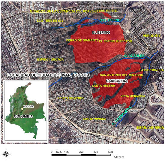
Figure 1.
Satellite image of the landslide zone under study: ‘Altos de la Estancia’ (AE). Black line: Geographic boundary, red: Landslide zone (‘El Espino’ and ‘La Carbonera’), and blue: Drainage network.
2.2. Data Collection
This research compiled data from various studies conducted by different companies and entities contracted by the mayor’s office of the megacity between 1997 and 2015. The megacity administration, through its Risk Management Office, conducted multiple geological and geotechnical studies (https://www.idiger.gov.co/, accessed on 1 February 2021) [50]. The studies considered for this research include those conducted by ‘Ingeocin Ltda.’ [51], ‘Investigaciones Geotécnicas’ [52], ‘Consorcio Civiles Ltda. and Hidroconsulta Ltda.’ [53], ‘Geotecnia and Cimentaciones Ltda.’ [54], ‘Ingeominas’ [55], ‘Ingeniería and Georriesgos’ [56], and ‘FOPAE’ [57]. Estancia [58] provided a geomorphological evolution model and characteristics of the landslide under study, which also contributed to this research. These studies provided valuable insights into planning approaches and landslide evolution during the study period.
The study was temporally delimited between 1952 and 2015, with consideration given to information from the nineteenth and twentieth centuries regarding urban planning approaches in the megacity [50]. Spatial data, including land use, land cover, and morphology, were collected for analyzing changes in the landslide’s physical conditions. Aerial photographs (1.0 m resolution) from the ‘Instituto Geográfico Agustín Codazzi’ (IGAC, https://www.igac.gov.co/, accessed on 15 March 2022) [59] and satellite images from sensors like Landsat (30 m resolution), Ikonos (4 m resolution), and Quickbird (2.44 m resolution, https://earthexplorer.usgs.gov/, accessed on 1 April 2022) [60] were utilized. These images captured terrain details and vegetation changes associated with the landslide, while QuickBird and Ikonos images facilitated detailed mapping and monitoring. Landsat images were used for global coverage and long-term monitoring. Moreover, topographic and climatic data complemented the analysis. The study area was spatially delimited based on the established period (1952–2015), focusing on significant landslide events and associated land use and land cover changes.
2.3. Data Analysis
The information analysis methodology used in this study to assess the spatiotemporal evolution of a landslide risk scenario within the framework of urban planning involved a multidisciplinary approach. Firstly, a comprehensive analysis of land use changes was conducted using remote sensing techniques and Geographic Information Systems [61] to evaluate alterations in land cover over the study period (1952–2015). Secondly, an exhaustive documentary review and historical analysis were carried out to contextualize observed land use changes and identify potential factors contributing to the evolution of the landslide risk scenario [62]. This entailed examining archival records, urban planning documents, historical maps, and relevant literature to uncover socioeconomic, environmental, and political factors within the scope of this research. By integrating these two methodological approaches, a comprehensive understanding of the spatiotemporal dynamics of the landslide risk scenario and its implications within the framework of urban planning in the megacity was achieved.
Quantitative methods were used to analyze changes in land use, land cover, and geomorphology in the landslide zone studied [63]. Multitemporal mapping of land use, land cover, and geomorphology was based on 2D and 3D (stereoscopic) interpretations of remote sensing records at a scale of 1:500 [64]. Initially, the aerial photographs were georeferenced by associating each pixel with a specific location on the ground (control points). We also corrected the geometric distortions inherent to the aerial photographs (tilt and perspective) to align the image with a reference coordinate system (MAGNA-SIRGAS, GRS80) [65]. Next, we performed image quality enhancements (contrast, brightness, and saturation) and corrected visual artifacts that could affect the interpretation [65]. We also identified relevant features associated with the landslide zone (land use, land cover, and geomorphology). We then digitized and mapped the landslide area using GIS tools (ArcGIS V.10.3. Software) and created thematic layers according to the variables considered in this study [66]. On the other hand, digital processing of satellite images included import, geometric corrections (orthorectification), atmospheric corrections, radiometric corrections, spatial enhancement, spectral enhancement, generation of 3D views, and anaglyphs from reference surveys [67]. Vector interpretations of the images were performed with statistical analysis using ArcGIS V.10.3. Software [64].
The information analyzed made it possible to establish land use, land cover, and geomorphology between 1952 and 2015. Initially, the areas were quantified based on the land use, land cover, and morphological categories considered in this study, which will be specified below. A spatial analysis was performed to identify patterns and relationships between the variables considered [68]. Then, a spatiotemporal analysis was performed to identify the evolution of the landslide under study [69]. That is, the rates of change of the variables considered and the areas that underwent significant transformations were evaluated. The results of the analysis were then compared with field data and reference information (selected studies) to validate the accuracy of the interpretations and maps generated [70]. Thematic maps were created to communicate the results of the analysis performed in this study. Lastly, documents related to the occupation history of the AE zone were reviewed, taking as a frame of reference the urban planning processes of the megacity of Bogota [7,48,71,72,73].
Based on the analysis of all documentary and cartographic information, this study proceeded to establish the following five spatiotemporal analysis scenarios, between 1952 and 2015: rural/natural, mining, urban, landslide risk, and stabilization and environmental park. In addition, a sixth scenario related to the occurrence of the COVID-19 pandemic was established: informal reoccupation. For each of the six scenarios, the following variables (categories) related to changes in land use, land cover, and morphology were analyzed [74]: erosion, shrub vegetation, rocky outcrops, grasslands, mining-quarries, landslides, reptation (slow and gradual movement of land on steep slopes), urban, anthropic landfill, urban pastures, anthropic works, and urban parks. Finally, to evaluate the effectiveness of the intervention measures [75] taken by the megacity administration to mitigate landslide risk at the study site, an exhaustive analysis of the spatiotemporal evolution in each of the scenarios considered was carried out.
3. Results and Discussion
The spatiotemporal analysis revealed that transformations in land use, land cover, and morphology occurred in the AE zone, potentially influenced by agricultural, mining, and urban dynamics (Table 1). This analysis also enabled the detection of land degradation due to landslides. Variations in land use, land cover, and morphology were observed across the six analysis scenarios considered in this study (between 1952 and 2015), which will be independently analyzed in subsequent sections. The results suggested that the landslide (5.53 ha) and mining activity (13.8 ha) commenced in 1977 (Figure 2). This mining activity was accompanied by a significant loss of shrub vegetation (8.7 ha) and pasture (13.4 ha) in relation to the situation observed in 1952. In 1984, the area affected by mining activity increased (52.2%) compared to 1977 and continued to rise until 1993 (58.5%), when urban land use emerged for the first time (36.7 ha). In 1997, urban land use peaked (86.1 ha). Within four years, urban land use in the landslide zone grew by 134%. In 2004, the landslide area increased significantly (36.8 ha) compared to 1977 (5.53 ha), effectively generating a decrease in urban land use (17.8 ha compared to 1997). Lastly, in 2015, the landslide was fully controlled.

Table 1.
Variation in land use, land cover, and morphology in the study area (1952–2015).
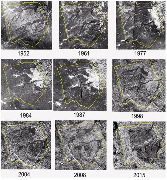
Figure 2.
Spatiotemporal variation in the landslide zone under study (1952–2015). Yellow line: geographic boundary.
3.1. Rural/Natural Scenario
The findings revealed that the urban development of Bogota commenced towards the late 19th and early 20th centuries. In the CB locality, where the AE zone was situated (southeast of the megacity), initial stages of agricultural parcelization and exploitation of construction materials were evident [76,77]. The analysis, based on the territory’s composition and morphology, indicated an occupation pattern characterized by a delay in public service provision (water and sewage) and limited road infrastructure improvement compared to other parts of the megacity. Pantoja [78] highlighted the non-uniform nature of the occupation process in the study area. Specifically, development began haphazardly in the lower landslide-prone zones, while higher elevations were utilized for agriculture and urban pastures. This disparity helped to explain the rural landscape detected in 1952 (Figure 3a).
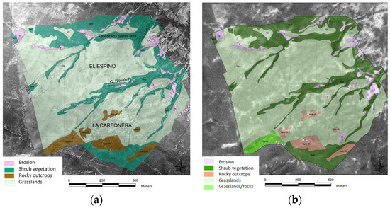
Figure 3.
Land cover, land use, and morphology for the rural/natural scenario in the landslide area under study (1952–1961). (a) 1952 and (b) 1961.
The results showed that at the outset of the 20th century, Bogota faced notable deficiencies in public service provision, particularly in peripheral areas, concerning water and sewage. Moreover, it was evident that the city’s land-use planning strategy predominantly favored central areas occupied by affluent social groups [48,73]. During this period, Agreements 10 of 1902 [79] and 6 of 1914 [80] were promulgated, aiming to establish guidelines for incorporating new land into the urbanization process, drawing from the urban planning traditions of Spanish colonizers and Creoles—descendants of Europeans born in Spanish territories in America [71]. Urbanism and urban planning have long been fundamental aspects of Latin American city development, tracing back to the Spanish conquest era [48]. Notably, French urbanism exerted a significant influence during the 19th century. In the case of Bogota, findings indicated the introduction of the ‘Future City Plan’ in the first two decades of the 20th century, formalized by Agreement 74 of 1925 [81]. This plan embraced the Damero design (chessboard or grid) inherited from Spanish colonization, extending towards the southwest and northwest zones of the megacity. Subsequently, in the ensuing two decades (1930–1940), Karl Brunner proposed a ‘Road Plan’ for urban planning in the central zone of the megacity [82]. Nevertheless, criticisms were raised regarding this urban planning approach. Cortés [71] and Montoya-Garay [48] contended that it fostered fragmented urbanism, lacking a comprehensive vision for the city’s development. Essentially, it catered to the needs of high-income sectors inclined towards abandoning the city center in favor of more commercially viable land use.
Additionally, the findings indicated that urban planning underwent a significant upheaval on 9 April 1949, following the devastation of the city center by fire and looting triggered by the death of a community leader [83]. This calamitous event catalyzed a reconstruction effort that partially aligned with the urban planning framework outlined in the ‘Le Corbusier Pilot Plan’ (1947–1953), envisioned for a city projected to accommodate 1,500,000 inhabitants over a span of 50 years. However, this ambitious urban plan faced hindrances in its full execution due to factors tied to Colombia’s political landscape and specific interests concerning urban land use [84]. Despite these setbacks, the plan encompassed pivotal elements crucial for the city’s future development, including a vision for regional planning, containment of urban sprawl westward, management of expansion towards the south and north, and the utilization of housing in the eastern mountainous region [71]. Consequently, the results suggested that while this urban plan may have effectively addressed functional zones within the city’s core, it overlooked burgeoning areas beyond its confines—such as the zone under scrutiny in the landslide study.
The results revealed that amidst the urban planning debates between the methodologies of Karl Brunner and the ‘Le Corbusier Pilot Plan’ (1952), the AE zone displayed a predominantly rural/natural (non-urbanized) landscape, characterized by grasslands (64.1%) and shrub vegetation (26.2%). This shrub vegetation predominantly surrounded the streams within the landslide-prone area (Santa Rita and Rosales streams), often concentrated in regions of steep incline (Figure 3a). Moreover, evidence of erosive water processes, such as gullies and laminar erosion, was identified, covering a total area of 4.47 ha (4.03%). The results indicated that initially, the lands within the landslide zone were utilized for grazing, yet their attributes hinted at the potential for mining exploitation, which could have contributed to the city’s physical expansion. Concurrently, the city witnessed rapid growth during this period. Furthermore, settlements in the form of small farms were noted in the lower and middle sections of the landslide-prone area (western zone, Figure 3b). Occupants primarily consisted of peasants migrating from regions affected by Colombian violence, characterized by political conflicts [76]. This context likely initiated a process of occupation within the landslide zone, diverging from established urban planning guidelines.
3.2. Mining Scenario
The findings indicated that the effectiveness of the ‘Le Corbusier Pilot Plan’ persisted nominally until the enactment of Agreement 51 in 1963 [85]. However, its implementation and principles were likely influenced by factors such as population expansion and the era of dictatorship in Colombia, which prioritized the execution of large-scale urban infrastructure projects over mitigating their socio-environmental repercussions. Consequently, there was a notable transition from the theoretical framework of this urban plan to its tangible manifestation in the physical development of the city [72]. In 1961, a new urban initiative, the ‘Pilot Road Plan,’ was introduced, aiming to reinforce the grid layout and establish concentric peripheral rings to foster a more compact urban environment. Nevertheless, this revised plan overlooked the potential ramifications of urban expansion, ultimately jeopardizing its own sustainability. As highlighted by Cortés [71], while municipal authorities endeavored to address interior deficiencies such as undeveloped lots, unauthorized urbanization proliferated along the city’s periphery via regional arterial roads. During this era, legislative measures including Agreement 65 of 1967 [86] and Decrees 1119 of 1968 [87] and 159 of 1974 [88] were implemented to regulate construction standards and procedures. However, these legal frameworks may have inadvertently fostered a fragmented approach to urban planning, diverging from the integrative vision advocated by the ‘Pilot Road Plan.’ Consequently, the city likely encountered unregulated growth in its peripheral regions, deviating from the established norms and regulations [89].
The investigation unveiled that the promulgation of Agreement 7 in 1979 [90] aimed to formalize the expansion of urbanization towards the western and southern fringes of the city, precisely where the focal landslide area was situated. This agreement facilitated the integration of neighborhoods into the extended urban periphery, delineating provisions for public services and land utilization, alongside establishing urban development categories [91]. Notably, the findings underscored construction as a pivotal driver of economic advancement in Colombia, particularly for urban centers like Bogota. Consequently, the study locale emerged as a crucial supplier of mining materials essential for the construction of various infrastructural and residential projects within the megacity. The landscape during this period was characterized by the exploitative extraction of construction materials from quarries. Moreover, the investigation unveiled that the progression of mining activities was marked by financial constraints, widespread poverty, and a dearth of technological sophistication [92]. These socioeconomic realities merited consideration concerning the operation of such industries in peripheral regions.
Additionally, the presence of economically disadvantaged settlements within the landslide zone facilitated access to low-cost labor. It was observed that during this scenario, six mining sites were operational within the megacity, with the CB region (comprising the landslide area) occupying a prominent position. The inception of mining activities predates the onset of urbanization, serving as a crucial supplier of construction materials to meet the burgeoning demands of an influx of migrants from diverse regions of the country, particularly gravitating towards the southern precincts of the city, including the subject landslide area. However, the consolidation of mining operations in the late 1950s was accompanied by extensive environmental degradation [93]. The findings indicated noteworthy fluctuations in mining and urban land utilization between 1977 and 1993 (Figure 4). Notably, mining land usage expanded significantly by 9.8 ha (representing a 71.0% increase) during this period. Conversely, the landslide area remained relatively stable in relation to the rural/natural scenario, spanning approximately 5.0 hectares. The urban land utilization experienced a substantial surge, encompassing an additional 36.7 hectares during this timeframe. This urban expansion was absent in the preceding rural/natural scenario observed between 1952 and 1961.
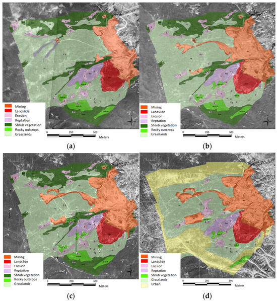
Figure 4.
Change in land use, land cover, and morphology during the mining scenario in the landslide area under study (1977–1993). (a) 1977, (b) 1984, (c) 1987, and (d) 1993.
3.3. Urban Scenario
The results indicated that economic planning took precedence over urban planning in the city. The country had an urgent need to solidify its economic growth, with construction emerging as a crucial sector to achieve this objective. Urban planning regulations were primarily geared towards facilitating this economic agenda [94,95]. Furthermore, the findings revealed the emergence of concepts such as self-regulated density, determined by market forces and the decisions of owners and developers. However, these density considerations did not contribute to the spatial segregation process within the city. This was mainly because the planning guidelines were predominantly designed for the formal city, resulting in significant challenges in their application in the southern region of the city. In this area, factors such as economic activity, valuation processes, and road hierarchies did not operate in the same manner as in the northern part of the city [71]. It is worth noting that during the 1970s, the Inter-American Development Bank (IDB) extended a loan to the city known as the ‘Integral Urban Development Program for the Eastern Zone of Bogota’ (PIDUZOB). This initiative aimed to support the execution of projects in deficit zones, including the landslide area under study. During this urban scenario, the landslide area was already recognized as a source of social and urban disarray [96].
Additionally, the findings revealed that in the 1980s, Decrees 1025 of 1987 [97] and 67 of 1988 [98] were issued, leading to the deregulation of the construction process within the city. Consequently, urban planning regulations ceased to function as instruments for land control and revaluation [99]. Concurrently, with the new loan from the IDB, a subsequent phase of the PIDUZOB was initiated, targeting the problematic areas of the city, including the area of the study landslide. This phase involved various infrastructure projects, such as road construction, provision of public services, establishment of social amenities, and the implementation of a housing program known as ‘Lots with Services,’ endorsed by the World Bank [100]. Moreover, the results indicated that Bogota Council enacted Agreement 11 of 1983 [101], delineating the Plan for CB (the landslide under study), aimed at earmarking the CB area for urban expansion, particularly for lower-income residents, given the lower agricultural suitability of the locality [76]. Furthermore, official studies conducted by entities such as the ‘Secretariat of Social Integration of Bogota’ [102] identified three key issues associated with urban planning in the landslide area under investigation. Firstly, there was a significant influx of population displaced by political violence from various parts of the country, with these communities seeking refuge in the landslide zone. Secondly, the government’s ‘Lots with Services’ program indirectly encouraged the occupation of the landslide zone by promoting self-built housing. Lastly, the accessibility of land for housing became entangled with clientelism, wherein individuals sought land through local politicians or social organizations, resulting in the illegal occupation of land and construction practices that did not meet the basic requirements for suitable urban settlement.
The findings indicated that the study area had previously served to accommodate low-cost housing, as well as populations migrating from various regions of the country and those displaced by violence. Essentially, by informally allocating this urban land, other areas of the city were relieved from these urban pressures. It was observed that between 1996 and 1997, there was a notable 61.8% increase in the utilization of urban land in the landslide-affected area (Figure 5). Moreover, an irregular urban landscape was evident in the study site during this period, characterized by a lack of clearly defined roadways and public service networks.
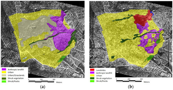
Figure 5.
Change in land use, land cover, and morphology during the urban scenario in the landslide area under study (1996–1997). (a) 1996 and (b) 1997.
In addition, the results indicated that during the urban scenario, there was an increase in the commercialization of land targeting individuals with low incomes. Lots were sold at very low prices, albeit without access to public services [76]. As previously noted, this period saw the emergence of the ‘Lots with Services’ program, which was funded by a USD 115 million loan from the IDB, supplemented by an additional USD 120 million contribution from the mayor’s office of the megacity. Once the study area had been occupied with rudimentary urban planning, the local administration began installing a basic network of public services, paving main streets, and initiating neighborhood legalization processes. Consequently, the landslide zone became an attractive option for new residents, as acquiring housing or developable land in other parts of the city was economically unfeasible [103]. Lastly, as an immediate consequence of this unplanned urbanization, natural watercourses were effectively buried under human-made landfills, leading to the emergence of a landslide zone on the northeast side (‘El Espino’, area = 6.68 ha) due to instability in 1997 (Figure 5b).
3.4. Landslide Risk Scenario
The results indicated that by the late 1990s, as the occupation of the study site (AE) reached a relative consolidation, a process of deurbanization (movement from urban to rural areas) linked with an increase in landslide occurrences gradually emerged. It was noted that state agencies adhered to the agreements outlined in the ‘Habitat I and II Conferences’ [104]. Essentially, urban planning efforts were directed towards addressing issues related to resettling the population affected by landslides. Activities included relocating households at risk of landslides, granting property titles, and undertaking engineering works (anthropic interventions) to improve the AE zone. This process continued until 2013 (Figure 6). Furthermore, the results revealed a pattern of houses being destroyed by landslides as state agencies proceeded with relocating inhabitants.
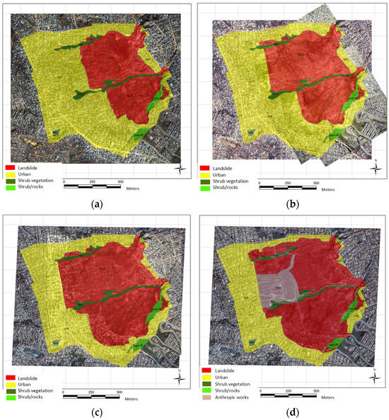
Figure 6.
Change in land use, land cover, and morphology during the landslide risk scenario in the area under study (2004–2013). (a) 2004, (b) 2007, (c) 2010, and (d) 2013.
The findings highlighted that in 1997, the landslide area covered 6.68 ha, expanding to 36.8 ha (551%) by 2004. By 2013, the landslide area further increased to 56.1 ha, indicating a pronounced upward trend during the study period (840%). Moreover, community-initiated actions were observed starting from 2006. Specifically, the community pursued legal action against the ‘Fund for the Prevention and Attention to Emergencies of Colombia’ (FOPAE) and the ‘Bogota Aqueduct and Sewage Company.’ Through this avenue of citizen participation, demands were made for the advancement of mitigation works and the provision of aqueduct and sewerage networks, within the framework of the ‘Recovery Plan of the AE Zone’ [56].
Therefore, the results suggested that the absence of urban planning in the AE zone necessitated significant investments by the local government in the medium to long term to address the risk situations that arose. Moreover, socio-environmental costs were likely incurred due to the urban degradation process triggered by the studied landslide (Figure 6).
The results showed that institutional management of the imminent landslide risk commenced in the late 1990s. The FOPAE identified the landslide, necessitating the relocation of affected families [76]. Engineering works were also undertaken (Figure 6), primarily in ‘La Carbonera’ (Figure 1). Despite these interventions, the landslide continued to exhibit activity, leading to the generation of the two strongest landslides observed at the study site in April 2000 and May 2002 [57]. The first slide had an elevation of 15 m, while the second slide formed a crack 30 m deep. During the latter event, 804 houses were damaged [105]. The findings suggested that this landslide was the largest recorded in the city of Bogota and the largest in urban areas in Latin America, covering 73 ha and affecting 16 neighborhoods in the AE zone [106]. The initial intervention in the AE zone by the megacity administration focused on the resettlement of 3033 families and the geomorphological recovery of the landslide area deemed to be at significant risk. According to data presented at the ‘Ibero-American and Caribbean Forum of Best Practices’ [103], by 2005, 50% of the affected families had been resettled. It was also reported that by 2014, over 5000 families had been relocated from the area affected by the landslide [76].
3.5. Stabilization and Environmental Park Scenario
The results indicated that once the houses affected by landslides (high threat) were evacuated and removed, landslide stabilization works commenced in 2013, involving the construction of retaining walls, drainage channels, terraces, and reforestation efforts. This led to the creation of an intervention landscape with engineering works (anthropic works, Figure 7). Moreover, the findings highlighted that upon the completion of landslide stabilization works, the mayor’s office of Bogota proposed a ‘Strategic Urban Intervention Plan’ for the AE zone through the enactment of Decree 489 of 2012 [107]. This decree prioritized the recovery process through inter-institutional actions in the risk zone.
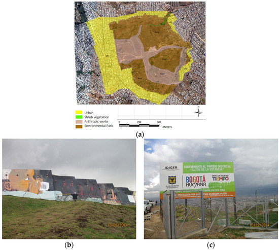
Figure 7.
Change in land use, land cover, and morphology during the stabilization and environmental park scenario in the area under study (2013–2015). (a) 2015, (b) retaining wall, and (c) environmental park.
Subsequently, Decree 364 of 2013 established the ‘Altos de la Estancia District Park’ (Figure 7) [57]. In December 2012, the megacity administration completed the mitigation works in the EA zone, with an investment of USD 6.75 million. Water management systems were implemented, and live fences were planted [106]. In 2013, a project called the ‘Urban Improvement Plan’ was proposed for the AE zone, comprising intervention lines in land clearance, family resettlement, and housing improvement, with an estimated value of USD 19.3 million [108].
The results suggested that for multilateral cooperation agencies, the AE zone phenomenon served as an example of urban development of illegal origin, characterized by a significant urban planning deficit and a population living in precarious economic conditions. Indeed, its evolution resulted in a high level of environmental deterioration. This landslide affected 13 neighborhoods and endangered the lives of 3000 families (15,000 people) in the megacity [103].
3.6. Informal Reoccupation Scenario
The findings revealed that, associated with the situation of isolation due to COVID-19 in Colombia, an illegal reoccupation by 300 families was observed in the EA zone since March 2020 [109]. This posed a significant problem in the sector, as it involved the occupation of the established environmental park and the construction of housing without adequate conditions, using materials such as cardboard, tiles, and construction waste. Subsequently, the authorities of the megacity initiated risk socialization processes and evicted these temporary dwellings. This situation underscored the complex nature of urban occupation in the AE zone, despite its designation as a risk and environmental recovery zone.
Comparison with other related studies [110] indicated that 89% of landslide-related deaths occurred in countries belonging to the Pacific region, typically comprising developing nations. Among Latin American countries, Brazil was the most affected by landslide deaths, averaging 88 deaths per year. Notably, the Campos do Jordão landslide [111] in Brazil highlighted issues related to environmental quality, urban segregation, and risk conditions similar to those observed in the AE zone. Similarly, the AE area exhibited common characteristics with the situation in the Campania region of Italy [112], where landslides resulted from long-term processes posing risks to urban areas.
Finally, the results suggested that the urban consequences were evident when landslide risk, the lack of adequate control from urban planning guidelines, and the significant population concentration in megacities in developing countries converged.
3.7. Effectiveness of Intervention Measures
To assess the effectiveness of the intervention measures taken by the administration of the megacity to mitigate the risk of landslides at the study site, it was necessary to conduct a comprehensive analysis of the spatiotemporal evolution in each of the considered scenarios.
The results hinted at a transformation in land use, vegetation cover, and morphology, influenced by agricultural, mining, and urban dynamics. Initially characterized by rural and natural landscapes, the area gradually experienced mining activities, followed by rapid urbanization. Despite urban planning efforts, such as ‘Le Corbusier’s Pilot Plan’ and subsequent regulatory agreements aimed at controlling urban growth, the area witnessed disorderly urbanization, informal settlements, and inadequate provision of public services. Consequently, landslide risks significantly increased over time, leading to destructive events and displacement of affected families. Subsequent intervention measures focused on stabilization and environmental restoration, including the creation of parks and infrastructure improvements.
However, challenges persist, as evidenced by informal reoccupation observed during the COVID-19 pandemic, highlighting the complex and ongoing nature of urban development and risk management in the study megacity. Therefore, while progress has been made in mitigating landslide risks, the effectiveness of intervention measures remains limited by issues such as inadequate urban planning, socioeconomic disparities, and environmental degradation.
4. Conclusions
The findings demonstrate that the urban planning approach inherited from the Spanish colonial system erroneously privileges the central zones and does not designate an adequate role for the peripheral zones of the megacity. This contributes to the generation of illegal occupation processes of the territory, intensified by processes of landslides and massive displacement due to episodes of violence (armed conflict). The results also suggest that the existence of this type of landslide risk scenario has environmental implications due to the deterioration of natural resources and an enormous socioeconomic burden for the community involved, which must endure a decrease in its quality of life, competitiveness, and sustainability. In this study, the following analysis scenarios are established according to the observed chronology in the urban landslide: rural and natural (initial status), mining (economic exploitation), urban (unplanned occupancy), landslide risk (threat/disaster), stabilization and environmental park (mitigation/investment), and informal reoccupation (illegal occupation). These analysis scenarios evidence the dominant use of a reactive urban planning approach that responds to events, changes, or problems that have already occurred, rather than adopting a planning approach that anticipates and prevents potential risks at the study site.
Additionally, the results show the complex relationship between the peripheral zones of a Latin American megacity with limitations for the location of low-income human settlements and the potential of these zones for the exploitation of construction materials (mining). This complex relationship is also intensified by the weakness in the administrative processes of planning and control of these occupations, and the growing demands for access to land for residential use in a context of landslide risk. The land use transformations detected also show different historical moments, which evolve up to a moment of landslide disaster. This disaster then requires a radical and significant intervention, which generates high economic costs for the megacity administration (stabilization and socio-environmental recovery works). Subsequently, the maintenance of residential land use and the creation of special environmental management zones (environmental park) generate a great challenge for the megacity administration. This is possibly because other factors generating the risk situation (e.g., competition for residential land and economic restrictions) continue and generate significant urban pressure, as shown by the new illegal occupation attempts in 2020 with the beginning of the COVID-19 pandemic.
This study can become a reference point for public and private organizations to identify key scenarios and factors during landslide risk processes in urban areas. Indeed, these key scenarios and factors are probably the main ones to be considered to improve urban planning processes in megacities in developing countries. However, this study has the following limitations, which require special attention. First, the six scenarios established focus exclusively on the analysis of factors affecting the urban planning process in the studied landslide area. In other words, this study does not propose possible strategies for the improvement of urban planning in the landslide area. Thus, this limitation becomes a possible line of research for the development of future studies. Second, the use of aerial photographs and satellite images was not continuous over time. That is, this information depended on their availability in the information sources consulted, which possibly prevented the identification of other analysis scenarios during the development of this study. Third, we believe that this type of study requires direct fieldwork with the affected population. Thus, the time scale considered in this study (63 years) was a limiting factor.
Author Contributions
Conceptualization, G.V.-C. and Y.T.H.-P.; Methodology, G.V.-C., Y.T.H.-P. and C.A.Z.-M.; Software, G.V.-C.; Validation, G.V.-C., Y.T.H.-P. and C.A.Z.-M.; Formal analysis, G.V.-C., Y.T.H.-P. and C.A.Z.-M.; Investigation, Y.T.H.-P.; Resources, Y.T.H.-P. and C.A.Z.-M.; Data curation, Y.T.H.-P. and C.A.Z.-M.; Writing—original draft, Y.T.H.-P. and C.A.Z.-M.; Writing—review & editing, C.A.Z.-M.; Visualization, G.V.-C. and C.A.Z.-M.; Supervision, Y.T.H.-P.; Project administration, Y.T.H.-P.; Funding acquisition, Y.T.H.-P. and C.A.Z.-M. All authors have read and agreed to the published version of the manuscript.
Funding
This research received no external funding.
Data Availability Statement
The original contributions presented in the study are included in the article material; further inquiries can be directed to the corresponding author/s.
Acknowledgments
The authors wish to acknowledge the support provided by the research groups in Environmental Engineering (GIIAUD) and Sustainable Development (INDESOS) of the Universidad Distrital Francisco José de Caldas (Colombia).
Conflicts of Interest
The authors declare no conflict of interest.
References
- March, A.; Kornakova, M.; Handmer, J. Chapter 2—Urban Planning and Recovery Governance. In Urban Planning for Disaster Recovery; March, A., Kornakova, M., Eds.; Butterworth-Heinemann: Boston, MA, USA, 2017; pp. 13–30. ISBN 978-0-12-804276-2. [Google Scholar]
- Bakhtiari, V.; Piadeh, F.; Chen, A.S.; Behzadian, K. Stakeholder Analysis in the Application of Cutting-Edge Digital Visualisation Technologies for Urban Flood Risk Management: A Critical Review. Expert Syst. Appl. 2024, 236, 121426. [Google Scholar] [CrossRef]
- Ramirez Lopez, L.J.; Grijalba Castro, A.I. Sustainability and Resilience in Smart City Planning: A Review. Sustainability 2021, 13, 181. [Google Scholar] [CrossRef]
- Galdini, R.; De Nardis, S. Urban Informality and Users-Led Social Innovation: Challenges and Opportunities for the Future Human Centred City. Futures 2023, 150, 103170. [Google Scholar] [CrossRef]
- Ligthart, F. Practical and Theoretical Issues: Integrating Urban Planning and Emergency Management; Australian National University: Canberra, Australia, 2018. [Google Scholar]
- Ganeshu, P.; Fernando, T.; Keraminiyage, K. Barriers to, and Enablers for, Stakeholder Collaboration in Risk-Sensitive Urban Planning: A Systematised Literature Review. Sustainability 2023, 15, 4600. [Google Scholar] [CrossRef]
- Ramírez Ríos, J.F. La planeación urbana en Colombia: Años sesenta-ochenta. Discursos, consultores y comunidades académicas. Rev. Estud. Soc. 2011, 40, 115–125. [Google Scholar]
- Fathi, S.; Sajadzadeh, H.; Mohammadi Sheshkal, F.; Aram, F.; Pinter, G.; Felde, I.; Mosavi, A. The Role of Urban Morphology Design on Enhancing Physical Activity and Public Health. Int. J. Environ. Res. Public Health 2020, 17, 2359. [Google Scholar] [CrossRef]
- Pozoukidou, G.; Chatziyiannaki, Z. 15-Minute City: Decomposing the New Urban Planning Eutopia. Sustainability 2021, 13, 928. [Google Scholar] [CrossRef]
- Carmona, M. Public Places Urban Spaces: The Dimensions of Urban Design, 3rd ed.; Routledge: New York, NY, USA, 2021; ISBN 978-1-315-15845-7. [Google Scholar]
- Kimic, K.; Ostrysz, K. Assessment of Blue and Green Infrastructure Solutions in Shaping Urban Public Spaces—Spatial and Functional, Environmental, and Social Aspects. Sustainability 2021, 13, 11041. [Google Scholar] [CrossRef]
- Kutty, A.A.; Abdella, G.M.; Kucukvar, M.; Onat, N.C.; Bulu, M. A System Thinking Approach for Harmonizing Smart and Sustainable City Initiatives with United Nations Sustainable Development Goals. Sustain. Dev. 2020, 28, 1347–1365. [Google Scholar] [CrossRef]
- O’Byrne, M.C. Apuntes sobre el Centro Cívico del plan director de Le Corbusier para Bogotá. Blanco Rev. Arquit. 2013, 5, 6–12. [Google Scholar] [CrossRef][Green Version]
- Živković, J. Urban Form and Function. In Climate Action; Leal Filho, W., Azul, A.M., Brandli, L., Özuyar, P.G., Wall, T., Eds.; Encyclopedia of the UN Sustainable Development Goals; Springer International Publishing: Cham, Switzerland, 2020; pp. 862–871. ISBN 978-3-319-95885-9. [Google Scholar]
- Gaglione, F.; Gargiulo, C.; Zucaro, F.; Cottrill, C. Urban Accessibility in a 15-Minute City: A Measure in the City of Naples, Italy. Transp. Res. Procedia 2022, 60, 378–385. [Google Scholar] [CrossRef]
- Bibri, S.E.; Krogstie, J.; Kärrholm, M. Compact City Planning and Development: Emerging Practices and Strategies for Achieving the Goals of Sustainability. Dev. Built Environ. 2020, 4, 100021. [Google Scholar] [CrossRef]
- Khavarian-Garmsir, A.R.; Sharifi, A.; Hajian Hossein Abadi, M.; Moradi, Z. From Garden City to 15-Minute City: A Historical Perspective and Critical Assessment. Land 2023, 12, 512. [Google Scholar] [CrossRef]
- Schebek, L.; Lützkendorf, T. Assessing Resource Efficiency of City Neighbourhoods: A Methodological Framework for Structuring and Practical Application of Indicators in Urban Planning. Sustainability 2022, 14, 7951. [Google Scholar] [CrossRef]
- Menzori, I.D.; de Sousa, I.C.N.; Gonçalves, L.M. Urban Growth Management and Territorial Governance Approaches: A Master Plans Conformance Analysis. Land Use Policy 2021, 105, 105436. [Google Scholar] [CrossRef]
- Ronchi, S.; Arcidiacono, A.; Pogliani, L. Integrating Green Infrastructure into Spatial Planning Regulations to Improve the Performance of Urban Ecosystems. Insights from an Italian Case Study. Sustain. Cities Soc. 2020, 53, 101907. [Google Scholar] [CrossRef]
- Pineo, H.; Zimmermann, N.; Davies, M. Integrating Health into the Complex Urban Planning Policy and Decision-Making Context: A Systems Thinking Analysis. Palgrave Commun. 2020, 6, 21. [Google Scholar] [CrossRef]
- Duivenvoorden, E.; Hartmann, T.; Brinkhuijsen, M.; Hesselmans, T. Managing Public Space—A Blind Spot of Urban Planning and Design. Cities 2021, 109, 103032. [Google Scholar] [CrossRef]
- Segura Calero, S. Planificación comprehensiva en Estados Unidos: Evolución en el caso de Arizona y del condado de Pima. Bol. Asoc. Geógr. Esp. 2018, 9, 1–26. [Google Scholar] [CrossRef]
- Mukhopadhyay, C.; Faludi, A. Faludi: Introducing a Theory of Planning. Andreas Faludi in Conversation with Chandrima Mukhopadhyay; InPlanning: Groningen, The Netherlands, 2015; ISBN 978-94-91937-07-1. [Google Scholar]
- Pelorosso, R. Modeling and Urban Planning: A Systematic Review of Performance-Based Approaches. Sustain. Cities Soc. 2020, 52, 101867. [Google Scholar] [CrossRef]
- Cenci, A.; Cawthorne, D. Refining Value Sensitive Design: A (Capability-Based) Procedural Ethics Approach to Technological Design for Well-Being. Sci. Eng. Ethics 2020, 26, 2629–2662. [Google Scholar] [CrossRef]
- Arlati, A.; Rödl, A.; Kanjaria-Christian, S.; Knieling, J. Stakeholder Participation in the Planning and Design of Nature-Based Solutions. Insights from CLEVER Cities Project in Hamburg. Sustainability 2021, 13, 2572. [Google Scholar] [CrossRef]
- Rana, I.A.; Asim, M.; Aslam, A.B.; Jamshed, A. Disaster Management Cycle and Its Application for Flood Risk Reduction in Urban Areas of Pakistan. Urban Clim. 2021, 38, 100893. [Google Scholar] [CrossRef]
- Anttiroiko, A.-V. Successful Government Responses to the Pandemic: Contextualizing National and Urban Responses to the COVID-19 Outbreak in East and West. Int. J. E-Plan. Res. 2021, 10, 1–17. [Google Scholar] [CrossRef]
- Nochta, T.; Wan, L.; Schooling, J.M.; Parlikad, A.K. A Socio-Technical Perspective on Urban Analytics: The Case of City-Scale Digital Twins. J. Urban Technol. 2021, 28, 263–287. [Google Scholar] [CrossRef]
- Manny, L. Socio-Technical Challenges towards Data-Driven and Integrated Urban Water Management: A Socio-Technical Network Approach. Sustain. Cities Soc. 2023, 90, 104360. [Google Scholar] [CrossRef]
- Cascini, L.C.J.R.J.O.; Bonnard, C.; Corominas, J.; Jibson, R.; Montero-Olarte, J. Landslide Hazard and Risk Zoning for Urban Planning and Development; Hungr, O., Fell, R., Couture, R., Eberhardt, E., Eds.; CRC Press: Boca Raton, FL, USA, 2005; pp. 209–246. [Google Scholar]
- Salcedo, M.T. ¿Geohistoria o geoficción? ciudades vulnerables y justicia espacial, de Alain Musset. Rev. Colomb. Antropol. 2010, 46, 217–223. [Google Scholar] [CrossRef]
- Arias-Maldonado, M. COVID-19 as a Global Risk: Confronting the Ambivalences of a Socionatural Threat. Societies 2020, 10, 92. [Google Scholar] [CrossRef]
- Vergara-Pinto, F.; Marín, A. Stratigraphy of Volcanic Memory: Sociocultural Dimensions of Volcanic Risk in the Southern Andes, Chile. J. Conting. Crisis Manag. 2023, 31, 1018–1033. [Google Scholar] [CrossRef]
- Hoover, F.-A.; Lim, T.C. Examining Privilege and Power in US Urban Parks and Open Space during the Double Crises of Antiblack Racism and COVID-19. Socio-Ecol. Pract. Res. 2021, 3, 55–70. [Google Scholar] [CrossRef]
- Verheij, J.; Corrêa Nunes, M. Justice and Power Relations in Urban Greening: Can Lisbon’s Urban Greening Strategies Lead to More Environmental Justice? Local Environ. 2021, 26, 329–346. [Google Scholar] [CrossRef]
- Uluç Keçik, A.; Çiftçi, C.; Eren, Ş.G.; Tepecik Diş, A.; Rizzo, A. Determination and Evaluation of Landslide-Prone Regions of Isparta (Turkey): An Urban Planning View. Sustainability 2023, 15, 14329. [Google Scholar] [CrossRef]
- Mateos, R.M.; López-Vinielles, J.; Poyiadji, E.; Tsagkas, D.; Sheehy, M.; Hadjicharalambous, K.; Liscák, P.; Podolski, L.; Laskowicz, I.; Iadanza, C.; et al. Integration of Landslide Hazard into Urban Planning across Europe. Landsc. Urban Plan. 2020, 196, 103740. [Google Scholar] [CrossRef]
- Hostettler, S.; Jöhr, A.; Montes, C.; D’Acunzi, A. Community-Based Landslide Risk Reduction: A Review of a Red Cross Soil Bioengineering for Resilience Program in Honduras. Landslides 2019, 16, 1779–1791. [Google Scholar] [CrossRef]
- Chardon, A.C. Amenaza, vulnerabilidad y sociedades urbanas una visión desde la dimensión institucional. Gest. Ambiente 2008, 11, 123–135. [Google Scholar]
- Cannon, T.; Müller-Mahn, D. Vulnerability, Resilience and Development Discourses in Context of Climate Change. Nat. Hazards 2010, 55, 621–635. [Google Scholar] [CrossRef]
- UNU-WIDER. UNU-WIDER: Working Paper: Reducing People’s Vulnerability to Natural Hazards. Available online: http://www.wider.unu.edu/publication/reducing-people%E2%80%99s-vulnerability-natural-hazards (accessed on 19 December 2023).
- Milbert, I.; Nathan, F. Gestion du risque et politiques urbaines au Nord et au Sud. Trace Trav. Rech. Dans Amériques Cent. 2009, 26–40. [Google Scholar]
- East, J.; Montealegre, J.S.; Pachon, J.E.; Garcia-Menendez, F. Air Quality Modeling to Inform Pollution Mitigation Strategies in a Latin American Megacity. Sci. Total Environ. 2021, 776, 145894. [Google Scholar] [CrossRef] [PubMed]
- Goya-Heredia, A.V.; Zafra-Mejía, C.A.; Rondón-Quintana, H.A. Spatial Analysis of Heavy Metal Pollution in Road-Deposited Sediments Based on the Traffic Intensity of a Megacity. Atmosphere 2023, 14, 1033. [Google Scholar] [CrossRef]
- Bustamante-Zapata, A.M.; Zafra-Mejía, C.A.; Rondón-Quintana, H.A. Influence of Vegetation on Outdoor Thermal Comfort in a High-Altitude Tropical Megacity: Climate Change and Variability Scenarios. Buildings 2022, 12, 520. [Google Scholar] [CrossRef]
- Montoya-Garay, J.W. De La Ciudad Hidalga a La Metrópoli Globalizada. Una Historiografía Urbana y Regional de Bogotá; Universidad Nacional de Colombia: Bogotá, Colombia, 2014; ISBN 978-958-783-314-0. [Google Scholar]
- Herrera-Coy, M.C.; Calderón, L.P.; Herrera-Pérez, I.L.; Bravo-López, P.E.; Conoscenti, C.; Delgado, J.; Sánchez-Gómez, M.; Fernández, T. Landslide Susceptibility Analysis on the Vicinity of Bogotá-Villavicencio Road (Eastern Cordillera of the Colombian Andes). Remote Sens. 2023, 15, 3870. [Google Scholar] [CrossRef]
- IDIGER. Inicio-IDIGER. Available online: https://www.idiger.gov.co/home (accessed on 20 December 2023).
- Ingeocim Ltda. Zonificación por Inestabilidad del Terreno para Diferentes Localidades en la Ciudad de Santafé de Bogotá D.C. 1998. Available online: https://bibliotecadigital.sire.gov.co/handle/idiger/62711 (accessed on 1 December 2021).
- Investigaciones Geotécnicas Ltda. Zonificación de Riesgo por Movimientos de Remoción en Masa en 101 Barrios de la Localidad de Usme. 1998. Available online: https://bibliotecadigital.sire.gov.co/handle/idiger/62468 (accessed on 1 December 2021).
- Hidroconsulta Civiles Ltda. Estudio Geotécnico, Evaluación Alternativas de Medidas de Mitigación y Diseños para las obras entre las Quebradas Santo Domingo y Santa Rita, barrio El Espino. 1999. Available online: https://bibliotecadigital.sire.gov.co/handle/idiger/62647 (accessed on 1 December 2021).
- Cimentaciones, G. Monitoreo y Seguimiento del Deslizamiento que Afecta a los Barrios San Antonio del Mirador, Santa Helena, Santa Viviana, Vista Hermosa, Santo Domingo y la Carbonera. 2002. Available online: https://bibliotecadigital.sire.gov.co/bitstream/handle/idiger/54029/DI-3114.pdf?sequence=1 (accessed on 1 December 2021).
- Ingeominas. Estudio y Evaluación de Amenazas por Deslizamiento de los Barrios El Espino y Cerros del Diamante, Ciudad Bolívar-Bogotá. 2002. Available online: https://bibliotecadigital.sire.gov.co/handle/idiger/62662 (accessed on 1 December 2021).
- Georiesgos. Estudio de Riesgo y Medidas de Mitigación en el Sector altos de la Estancia de la Localidad de Ciudad Bolívar en la Ciudad de Bogotá, D.C. 2004. Available online: https://bibliotecadigital.sire.gov.co/bitstream/handle/idiger/54242/DI-3398.pdf?sequence=1&isAllowed=y (accessed on 1 December 2021).
- Estancia, C.A.D.L. Diseños Detallados, Presupuestos y Especificaciones Técnicas para la Construcción de las obras de Mitigación de Riesgos Requeridas en el Sector Altos de la Estancia de la Localidad de Ciudad Bolívar en la Ciudad de Bogotá. 2008. Available online: https://bibliotecadigital.sire.gov.co/handle/idiger/62800 (accessed on 1 December 2021).
- Estancia, C.A.D.L. Monitoreo Geotécnico Especializado en el Sector de Altos de la Estancia de la Localidad de Ciudad Bolívar. 2010. Available online: https://bibliotecadigital.sire.gov.co/handle/idiger/62743 (accessed on 1 December 2021).
- IGAC. Instituto Geográfico Agustín Codazzi. Available online: https://www.igac.gov.co/es (accessed on 20 December 2023).
- USGS. EarthExplorer. Available online: https://earthexplorer.usgs.gov/ (accessed on 20 December 2023).
- Atay Kaya, İ.; Kut Görgün, E. Land Use and Land Cover Change Monitoring in Bandırma (Turkey) Using Remote Sensing and Geographic Information Systems. Environ. Monit. Assess. 2020, 192, 430. [Google Scholar] [CrossRef] [PubMed]
- Piacentini, D.; Troiani, F.; Daniele, G.; Pizziolo, M. Historical Geospatial Database for Landslide Analysis: The Catalogue of Landslide OCcurrences in the Emilia-Romagna Region (CLOCkER). Landslides 2018, 15, 811–822. [Google Scholar] [CrossRef]
- Zhong, C.; Liu, Y.; Gao, P.; Chen, W.; Li, H.; Hou, Y.; Nuremanguli, T.; Ma, H. Landslide Mapping with Remote Sensing: Challenges and Opportunities. Int. J. Remote Sens. 2020, 41, 1555–1581. [Google Scholar] [CrossRef]
- Lima, S.M.S.A.; Lopes, W.G.R.; Façanha, A.C. Changes in Soil Coverage in Teresina City, Piauí State, Brazil. Soc. Nat. 2021, 33, e58922. [Google Scholar] [CrossRef]
- Ettehadi Osgouei, P.; Sertel, E.; Kabadayı, M.E. Integrated Usage of Historical Geospatial Data and Modern Satellite Images Reveal Long-Term Land Use/Cover Changes in Bursa/Turkey, 1858–2020. Sci. Rep. 2022, 12, 9077. [Google Scholar] [CrossRef] [PubMed]
- Mosaad, S.; Kotb, A.D.M.; Basheer, A.A. Groundwater Potentiality Mapping: A Case Study in Baba and Sidri Watersheds, South Sinai, Egypt. J. Afr. Earth Sci. 2024, 210, 105145. [Google Scholar] [CrossRef]
- Xie, S.; Liu, L.; Zhang, X.; Yang, J. Mapping the Annual Dynamics of Land Cover in Beijing from 2001 to 2020 Using Landsat Dense Time Series Stack. ISPRS J. Photogramm. Remote Sens. 2022, 185, 201–218. [Google Scholar] [CrossRef]
- Franch-Pardo, I.; Napoletano, B.M.; Rosete-Verges, F.; Billa, L. Spatial Analysis and GIS in the Study of COVID-19. A Review. Sci. Total Environ. 2020, 739, 140033. [Google Scholar] [CrossRef] [PubMed]
- Wu, C. Using the Spatiotemporal Hot Spot Analysis and Multi-Annual Landslide Inventories to Analyze the Evolution and Characteristic of Rainfall-Induced Landslide at the Subwatershed Scale in Taiwan. Water 2023, 15, 1355. [Google Scholar] [CrossRef]
- Kontoes, C.; Loupasakis, C.; Papoutsis, I.; Alatza, S.; Poyiadji, E.; Ganas, A.; Psychogyiou, C.; Kaskara, M.; Antoniadi, S.; Spanou, N. Landslide Susceptibility Mapping of Central and Western Greece, Combining NGI and WoE Methods, with Remote Sensing and Ground Truth Data. Land 2021, 10, 402. [Google Scholar] [CrossRef]
- Cortés, R. Del Urbanismo a La Planeación En Bogotá (1900–1990) Esquema Inicial y Materiales Para Pensar La Trama de Un Relato. Rev. Bitácora Urbano Territ. 2007, 11, 160–213. [Google Scholar]
- Hernández Rodríguez, C.E. De Le Corbusier a Sert en el Plan Director de Bogotá 1947–1953. Ph.D. Thesis, Repositorio Universidad Nacional, Bogotá, Colombia, 2017. [Google Scholar]
- Mejía, G. Los Años Del Cambio: Historia Urbana de Bogotá, 1820–1910; Pontificia Universidad Javeriana: Bogotá, Colombia, 2000; ISBN 978-958-683-308-0. [Google Scholar]
- Tyagi, A.; Tiwari, R.K.; James, N. Mapping the Landslide Susceptibility Considering Future Land-Use Land-Cover Scenario. Landslides 2023, 20, 65–76. [Google Scholar] [CrossRef]
- Morar, C.; Lukić, T.; Basarin, B.; Valjarević, A.; Vujičić, M.; Niemets, L.; Telebienieva, I.; Boros, L.; Nagy, G. Shaping Sustainable Urban Environments by Addressing the Hydro-Meteorological Factors in Landslide Occurrence: Ciuperca Hill (Oradea, Romania). Int. J. Environ. Res. Public Health 2021, 18, 5022. [Google Scholar] [CrossRef]
- Huertas, D.P.V.; Ruiz, J.C. Resiliencia y organización comunitaria: El caso de la red de huertas en los Altos de la Estancia, en la localidad de Ciudad Bolívar en Bogotá. Ciudad Pazando 2015, 8, 65–85. [Google Scholar] [CrossRef][Green Version]
- Torres Tovar, C.A.; Robles Joya, S. Estrategias de inclusión-exclusión de la ciudad colombiana autoproducida mediante políticas de reasentamiento barrial. Bull. L’institut Français D’études Andin. 2014, 43, 587–609. [Google Scholar] [CrossRef]
- Pantoja, F.Z. Historia de la Localidad de Tunjuelito: El Poblamiento del Valle Medio del Río Tunjuelo; Alcaldía Mayor de Bogotá: Bogotá, Colombia, 2004; ISBN 978-958-701-360-3. [Google Scholar]
- Pardo, R. Acuerdo Número 10 De 1902 Reglamentando Las Construcciones, Apertura de Calles, Urbanización de Terrenos; Consejo Municipal de Bogotá: Bogotá, Colombia, 1902. Available online: https://biblioarchivo.bogota.gov.co/cgi-bin/koha/opac-detail.pl?biblionumber=94550 (accessed on 20 December 2022).
- Acuerdo 6 de 1914 Concejo de Bogotá, D.C. Available online: https://www.alcaldiabogota.gov.co/sisjur/normas/Norma1.jsp?i=10077 (accessed on 20 December 2023).
- Acuerdo 74 de 1925 Concejo de Bogotá, D.C. Available online: https://www.alcaldiabogota.gov.co/sisjur/normas/Norma1.jsp?i=10031 (accessed on 20 December 2023).
- Arango López, D. Historia de una configuración profesional de urbanismo. Karl Brunner en Bogotá, 1933–1940. Cuad. Vivienda Urban. 2018, 11, 2. [Google Scholar] [CrossRef]
- Cardeño Mejía, F.A. Historia Del Desarrollo Urbano Del Centro de Bogotá (Localidad De Los Mártires); Alcaldía Mayor de Bogotá, Secretaría Distrital de Cultura: Bogotá, Colombia, 2007; ISBN 978-958-8321-19-6. [Google Scholar]
- Restrepo Rojas, V.M. La Construcción Sntagónica de la Ciudad de Bogotá, debate en torno a la Reserva Thomas Van Der Hammen. 2019. Available online: https://bibliotecadigital.univalle.edu.co/entities/publication/76a04c14-b4cd-44d1-ab02-9367e1928e11 (accessed on 20 December 2022).
- Lemos, F.A. Le Corbusier en Bogotá: El Proyecto del “Grand Inmeuble”, 1950–1951; Universidad Nacional de Colombia: Bogotá, Colombia, 2008; ISBN 978-958-719-143-1. [Google Scholar]
- Acuerdo 65 de 1967 Concejo de Bogotá, D.C. Available online: https://www.alcaldiabogota.gov.co/sisjur/normas/Norma1.jsp?i=2955 (accessed on 20 December 2023).
- Decreto 1119 de 1968 Alcaldía Mayor de Bogotá, D.C. Available online: https://www.alcaldiabogota.gov.co/sisjur/normas/Norma1.jsp?dt=S&i=14948 (accessed on 20 December 2023).
- Decreto 159 de 1974 Alcaldía Mayor de Bogotá, D.C. Available online: https://www.alcaldiabogota.gov.co/sisjur/normas/Norma1.jsp?i=127457&dt=S (accessed on 20 December 2023).
- Ibañez, P. Crónicas de Bogotá-Tomo III. Available online: https://babel.banrepcultural.org/digital/collection/p17054coll10/id/2399 (accessed on 20 December 2023).
- Acuerdo 7 de 1979 Concejo de Bogotá, D.C. Available online: https://www.alcaldiabogota.gov.co/sisjur/normas/Norma1.jsp?i=902&dt=S (accessed on 20 December 2023).
- Ramírez García, N.L. El reemplazo de la Planeación Urbana por la Norma Urbana en Bogotá Durante la Década del 70; Universidad Nacional de Colombia: Bogotá, Colombia, 2020. [Google Scholar]
- Caribe, C.E. Industria Minera de los Materiales de Construcción. Su Sustentabilidad en América del Sur; Comisión Económica para América Latina y el Caribe: Santiago, Chile, 2004; ISBN 978-92-1-322582-0. [Google Scholar]
- Latorre, Á.M.L.R.; Tovar, M.H.T. Explotación minera y sus impactos ambientales y en salud. El caso de Potosí en Bogotá. Saúde Debate 2017, 41, 77–91. [Google Scholar] [CrossRef]
- Minvivienda Colombia: Cien Años de Políticas Habitacionales. Available online: https://www.minvivienda.gov.co/publicacion/colombia-cien-anos-de-politicas-habitacionales (accessed on 20 December 2023).
- Sarmiento-Rojas, J.A.; González-Sanabria, J.-S.; Hernández-Carrillo, C.G. Analysis of the Impact of the Construction Sector on Colombian Economy. Tecnura 2020, 24, 109–118. [Google Scholar] [CrossRef]
- Montenegro-Miranda, G. Pobreza urbana y mejoramiento integral de barrios en Bogotá. Cuad. Vivienda Urban. 2010, 3, 120–122. [Google Scholar]
- Decreto 1025 de 1987 Alcaldía Mayor de Bogotá, D.C. Available online: https://www.alcaldiabogota.gov.co/sisjur/normas/Norma1.jsp?i=1985 (accessed on 20 December 2023).
- Decreto 67 de 1988 Alcaldía Mayor de Bogotá, D.C. Available online: https://www.alcaldiabogota.gov.co/sisjur/normas/Norma1.jsp?i=3006 (accessed on 20 December 2023).
- Gómez Navas, D.; Serna Dimas, A. Procesos de construcción de ciudad y vivienda informal. El caso de las barriadas informales de los cerros orientales de Bogotá, Colombia. Cuad. Urbano Espac. Cult. Soc. 2016, 20, 95–118. [Google Scholar] [CrossRef]
- Pava Gómez, A.J.; Escallon Gartner, C. Planeación y gestión espontánea en Bogotá. Informalidad urbana, 1940–2019. Bitácora Urbano-Territ. 2020, 30, 75–89. [Google Scholar] [CrossRef]
- Acuerdo 11 de 1983 Concejo de Bogotá, D.C. Available online: https://www.alcaldiabogota.gov.co/sisjur/normas/Norma1.jsp?dt=S&i=906 (accessed on 20 December 2023).
- Alcaldía Mayor de Bogotá Ciudad Bolívar: Lectura de Realidades y Necesidades Territorio Pas. Available online: https://www.coursehero.com/file/56747639/19-ciudad-bolivar-lectura-de-realidades-paspdf/ (accessed on 13 December 2020).
- Colombia, F.H. Reasentamiento de Familias Localizadas en Alto Riesgo no Mitigable en El Sector de Altos de la Estancia; UN-Hábitat, Foro Iberoamericano y Del Caribe Sobre Mejores Prácticas: Bogotá, Colombia, 2005. [Google Scholar]
- Zuluaga Giraldo, L.M.; Grisales Vargas, A.L.; Zuluaga Giraldo, L.M.; Grisales Vargas, A.L. (In)Justicia Territorial En El Proceso de Urbanización. El Caso de Manizales. Rev. INVI 2018, 33, 79–103. [Google Scholar] [CrossRef]
- ISSMGE. The International Society for Soil Mechanics and Geotechnical Engineering. Available online: https://www.issmge.org/publications/publication/altos-de-la-estancia-a-large-landslide-area-in-bogota-colombia-history-and-remedial-measures (accessed on 20 December 2023).
- de Bogotá, A.M. Altos de La Estancia: Un Ejemplo de Resiliencia; Fondo de Atención y Prevención de Emergencias—FOPAE: Bogotá, Colombia, 2013. [Google Scholar]
- Alcaldía Mayor de Bogotá Decreto 489 de 2012 Alcaldía Mayor de Bogotá, D.C. Available online: https://www.alcaldiabogota.gov.co/sisjur/normas/Norma1.jsp?i=50070&dt=S (accessed on 20 December 2023).
- Camargo, M. Estudio Detallado de Amenaza y Riesgo por Movimientos en Masa y Definición de Medidas de Reducción en el barrio Mirador de la Localidad de Ciudad Bolívar. 2019. Available online: https://bibliotecadigital.sire.gov.co/handle/idiger/69321 (accessed on 20 December 2021).
- Martínez, J.M.Á.; Rojas, M.Y.C. “No pude aislarme en casa porque el gobierno me dejó sin casa”: Despojo y desigualdad socio espacial en tiempos de pandemia en Altos de la Estancia, sur de Bogotá, Colombia. Tlalli Rev. Investig. Geogr. 2021, 5, 33–57. [Google Scholar] [CrossRef]
- Aristizabal Giraldo, E.V.; Martínez, H.; Vélez Upegui, J.I. Una revisión sobre el estudio de movimientos en masa detonados por lluvias. Rev. Acad. Colomb. Cienc. Exactas Físicas Nat. 2010, 34, 209–228. [Google Scholar] [CrossRef]
- Filho, A.R. Os deslizamentos de encostas nas favelas em áreas de risco da “Suíça Brasileira” (The landslides of hillsides in the slum quarters in the areas of risk of “brazilian switzerland”). Acta Geogr. 2012, 6, 23–34. [Google Scholar] [CrossRef]
- Di Martire, D.; De Rosa, M.; Pesce, V.; Santangelo, M.A.; Calcaterra, D. Landslide Hazard and Land Management in High-Density Urban Areas of Campania Region, Italy. Nat. Hazards Earth Syst. Sci. 2012, 12, 905–926. [Google Scholar] [CrossRef]


Disclaimer/Publisher’s Note: The statements, opinions and data contained in all publications are solely those of the individual author(s) and contributor(s) and not of MDPI and/or the editor(s). MDPI and/or the editor(s) disclaim responsibility for any injury to people or property resulting from any ideas, methods, instructions or products referred to in the content. |
© 2024 by the authors. Licensee MDPI, Basel, Switzerland. This article is an open access article distributed under the terms and conditions of the Creative Commons Attribution (CC BY) license (https://creativecommons.org/licenses/by/4.0/).