Article

Sustainability of Historical Landscape to Gwanghalluwon Garden in Namwon City, Korea

1
College of Urban and Environmental Sciences, Peking University, Yiheyuan 5, Haidian District, Beijing 100871, China
2
Department of Urban and Regional Planning, Peking University, Yiheyuan 5, Haidian District, Beijing 100871, China
3
National Research Institute of Cultural Heritage, Cultural Heritage Adninstration, Yudeungro 927, Seogu, Daejeon 302-834, Korea
*
Author to whom correspondence should be addressed.
Sustainability 2015, 7(7), 8565-8586; https://doi.org/10.3390/su7078565
Submission received: 15 May 2015 / Revised: 26 June 2015 / Accepted: 26 June 2015 / Published: 2 July 2015
(This article belongs to the Special Issue Landscape and Sustainability)

Abstract

:
The present study was intend to track down the transitional process in which the hierarchical dominance in the urban structure of Namwon City shifted from the Namwoneupseong Walled Town to the area of Gwanghalluwon Garden by using cadastral data and various historical sources. It was aimed to find the factors regarding the transition and a sustainable development plan to the historical landscape. The results were as follows: First, the urban structure of former Namwon City has succeeded to a typical grid street structure of walled town. However, land use and urban landscape to an existing grid street structure and a modified grid street structure was formed by development of transportation in the city. In addition, as the fortress was demolished, land development expanded east and west along the railroad and Yochun River. Accordingly, the central areas of Namwon City also expanded and shifted from Namwoneupseong Walled Town to the new towns in the adjacent area. Secondly, lots transformation process of Gwanghalluwon Garden started the changing by transitioning from the pavilion of a past government office to tourist attraction in the novel Chunhyang-jeon, written during the Joseon Dynasty. It was transformed into the current area of Gwanghalluwon Garden through the regional expansion project in the 1960s, and the relocation of neighboring market in the 1970s by the conflagration. And Namwon County purchased these lands. Later, Gwanghalluwon Garden was designated a cultural asset and the current shape of Gwanghalluwon Garden has been preserved since then. Third, The secret of how Gwanghalluwon Garden has been able to survive as a “dominated landscape” is likely to be found in the relationship between the development of the city (external factor), historical landscapes (internal factor), and complex interactions of history, geography, culture, etc. Furthermore, each factor has served as a unique element in developing Gwanghalluwon Garden into a famous site. Now, people perceive the area surrounding Gwanghalluwon Garden as a valuable space. Fourth, to preserve Gwanghalluwon Garden’s important legacy as a historical landscape, it is necessary to shed new light on the awareness of values accumulated over time. Accordingly, the process by which a historical resource evolves in value, urban functions, and culture can be expected to have “unpredictable positive effects” in areas where cultural acts occur and society, environment, economics, etc. serve as motives to preserve the historical resource.

1. Introduction

In some of the historical cities of the world, fortresses form boundaries of city areas. Fortresses composed the urban infrastructure with urban expansion. Most of these areas belong to old downtowns used to be recognized as areas that inhibited the urban landscape. However, they are currently reconsidered as important elements of the historical landscape. Although restoration movements for historical cities have lately become more abundant, focusing on the historical value of such areas, it is still far from being ready to restore a prototype because the transition of urban structures has not been well enough understood and a rather passive attitude has been taken by paying attention to only seemingly “worthy” elements, ignoring the essential value of historical landscapes.
Recent history shows that interests in historical environments have extended to the historical landscapes that ultimately include all elements containing a visible historical significance [1]. In the past, a historical continuity was often disregarded for modernization in Asia. Most nations were eager to adopt Western style, while their traditional cultures have been neglected. The primary reason behind the destruction of large buildings can be explained quite simply: the cultural, symbolic and economic values were not as significant as the region’s urgency to adopt a new lifestyle, new structure, and utilize new materials for construction as well as earn a considerably large speculative profit [2].
However, preserving the cultural assets within the historical landscapes has depended only on preserving the original form, with no concern for the social situation. Cultural assets place special significance on scarcity regarding its achieved historical or academic value, while the historical landscape can include extensive regions beyond the range of single objects, which could emphasize the overall image and can comprehensively include both sociological and natural factors.
Especially Korea’s cultural assets require preservation of the entire cultural asset area, more so than other countries, because building arrangement and space composition is designed to merge with the natural environment [3]. Recently, focus has shifted away from solely preserving the individual cultural assets, as this is a notably narrow sense of preservation. There are rising efforts to preserve not only the individual cultural assets, but also the overall surrounding areas [4]. However, the extent of targeted objects for preservation, which include the surrounding area, only includes a limited scope and does not diverge from the narrow viewpoint of only focusing on the individual cultural asset. There is a struggle with the ability to change the scope of perception for what is necessary in regards to historical preservation.
Now, as a matter of history, in terms of preserving the principal value of an object, which can be affected by other factors, it is important to consider not only direct impact of the object itself, but also various external factors. Preservation of the main value of a particular object is not obtained by solely focusing on direct factors and effects, but by also considering those factors which are indirect factors. For example, In the case of the Unified Silla (BC 57-AD 935) Capital, restoration has been underway by the district unit for 20 years; however, even the restoration of the basic structures has yet to be completed.
Urban environment traces the history of past events, prior occupations and possession [5]. A multilateral effort is necessary, which includes tracing the changes of growth and development through history as well as factoring changes in society, both at the local and national level.
In this respect, the present study assumes an empirical research. This study chose a past city as an object of research, out of those that were formerly built in fortress structure and still preserve historically and culturally important elements, to understand how such a city, of historical value and importance, changed during urbanization and what factors were utilized in the process. The findings from this effort are expected to be used to restore and sustain the authenticity of historical landscapes. Particularly, studying the landscape for historical value and connecting phenomenon with an area, defining the regional development stage and development gap and also understanding developmental trends should be the preconditions for landscape restoration.
The elements of the city were physical boundary formed by a fortress. A fortress during the medieval period was the basic structure in determining the location, function and size of a city or a walled town. The arrangement of major functions inside each fortress is similar to that of a medieval fortress. Furthermore, the patterns of urban organization, which are created due to the collapse of a fortress in a developing city, are also similar to that in the medieval period [6].
This is the same case in Namwon City. Only part of the physical Namwoneupseong Walled Town remains as of today, which allows one to only assume its original form. Currently, Gwanghalluwon Garden is the most representative historical landscape in Namwon city. The paradigm of historical landscape was transferred to Gwanghallu Won Garden as a “dominated landscape”.
Within Gwanghalluwon Garden was the first pavilion (a high upper chamber) located in a vast granary in the Jeolla-Do Province. Built by Prime Minister Hwang-Hui, who was highly respected by the public, Gwanghalluwon Garden is an important landmark, in which master of lyric literature and provincial governor Jeong-Cheol embodied a cosmic symbolism utilizing Ojakgyo Bridge and Three Mysterious Groups of Islands.
Lately, the world is paying keen attention to the values of historical landscapes, which are utilized in order to form more cultural and creative cities, seeking to highlight their history and formulate their identity through studying the cases of European preservative endeavors on historical cities. Sasaki Masayuki (2004) mentioned Bologna (Italy), Kanazawa (Japan), Birmingham (UK), and Freiburg (Germany) as success cases of transforming “Doughnut Phenomenon”, though acknowledging the contribution of industrialization to rapid urbanization, by post-industrialism into cultural production cities through “the convergence of culture and economy” [7]. As M.R.G. Conzen’s urban morphology was introduced in Korea in the 1990s, his theory and methodology applied the domestic studies regarding land structure in a city. The primary focus of the studies was to track the transition of land patterns through examining urban tissue and transitional processes. Lee (1992) analyzed the spatial change of land by tracking the change of plot system [8]; Yang (1994) analyzed the characteristics of plot patterns and structure [9]. This approach of urban morphology method is useful in analyzing land patterns, especially more applicable to the historical cities of Korea.
Upon these theoretical backgrounds, the present study selected Namwon City, which is a historical city long representing the Jiri mountain area in Korea and which is built in a walled town, as a research object. The study aimed to track down the transitional process in which the hierarchical dominance in the urban structure of Namwon City shifted from Namwoneupseong Walled Town to the area of Gwanghalluwon Garden with help of cadastral data and various historical sources and factors regarding the transition. It also attempted to find a plan to develop sustainable historical landscape on the basis of its findings. As a result, this study finds its academic significance and relevance in the fact that it is an actual case study that can play a critical role in preserving and restoring the authenticity and integrity of a historical city.

2. Research Method

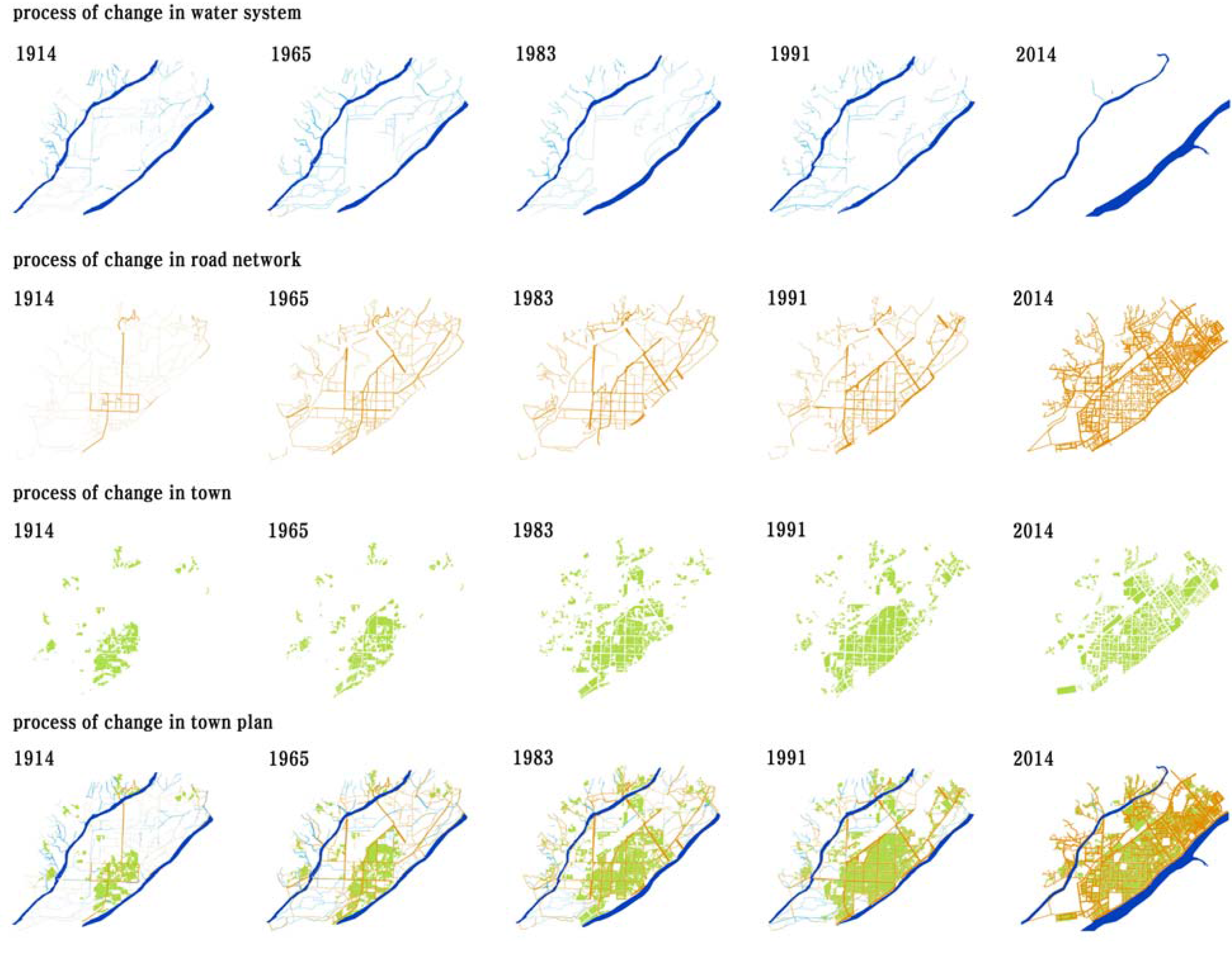
To demonstrate how the original landscape of Namwoneupseong Walled Town and Gwanghalluwon Garden has changed, and which factors have played a part in the transitional process, this study used macroscopic and microscopic approaches in conjunction: comparison with historical materials and cadastral maps. For the historical sources, this study examined Sam-Guk-Sa-Gi (1145, The Chronicles of the Three Kingdoms), Dong-Kuk-Yeo-Ji-Seung-Lam (1481), Ji-Sung map (1677), Hae-Dong-Ji-Do map (1750) as well as various county maps. Cadastral maps were used as cadastral data to track the transition pattern by period and ancient maps were used to define the original landscape before the existence of cadastral data. Both macroscopic and microscopic approaches were taken in carrying out analysis with cadastral maps. Looking into Namwon City and Namwoneupseong Walled Town, the macroscopic approach analyzed their geomorphological characteristics, such as route system, fixation line, central district and plane unit and urban plane composition, to understand the factors in the transitional process. In the meantime, the microscopic approach tracked down the details of the changes in the lots through the land registries and cadastral data of the whole Gwanghalluwon Garden area.
After tracking the transitional process and finding the political, economic and social preservation factors of Namwon City, this study analyzed the characteristics of Namwoneupseong Walled Town and Gwanghalluwon Garden (Figure 1), which is the dominated landscape of the Namwon region, and proposed a regional development plan for sustaining Namwoneupseong Walled Town by applied the Historic Urban Landscape (HUL) approach launched by UNESCO.
The present study took urban morphology and added to it microscopic methodology, which analyzes cadastral data such as lot change to better understand the detailed transition process of the historical landscape.
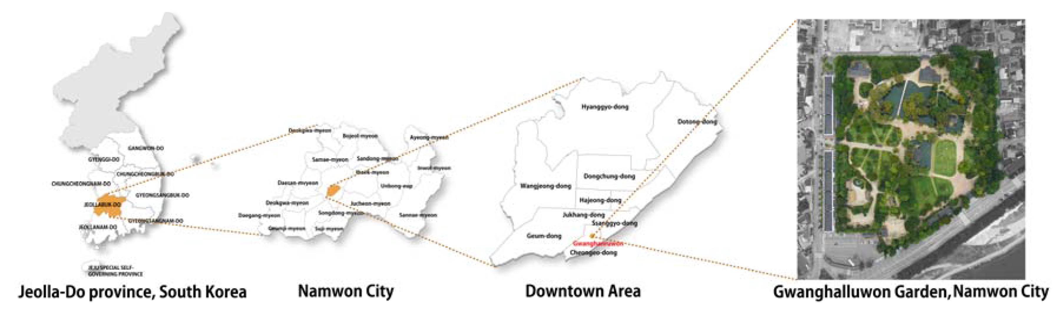
Figure 1. Location of the study area.
Sustainability 07 08565 g001

3. Results and Discussion

3.1. Transformation and Morphological Characteristics of Urban Form in Namwon City

3.1.1. Formation and Development of Urban in Namwon-Bu

According to Dong-Kuk-Yeo-Ji-Seung-Lam, which is the representative geographical book of the Joseon Dynasty (1392–1910), Namwon City was a county located in the southeast Jeolla-Do Province. It is surrounded by the Sumjingang River, which flows between Sobaek and Noryung Mountains. To its east and south, Namwon City is compartmentalized by Mt. Jiri and Mt. Gyoryong, and by Mt. Chungryung to its north. Yocheon River and Gwangchicheon streams flow from the northeastern to southwestern side. The section of “Silla-bongi”, in Sam-Guk-Sa-Gi, records that Namwon city was shaped in the form of a city during Shilla Dynasty. The section of Namwon Dohobu of Sin-Jung-Dong-Kuk-Yeo-Ji-Seung-Lam (1530) reads “Namwon town was divided into 9 areas by well-field system and the traces still remain”. It confirms that Namwon city was a walled town, of which the inner space was structured in a grid pattern by well-field system. Later, Namwon-bu (Namwon City’s old place-name in Joseon dynasty) was raised to the status of Namwon-gun in 1895 and Namwon-myun was raised to the status of Namwon-eup in 1931. On the 1 July, Namwon-eup was raised to the status of Namwon City and thus Namwon-gun and Namwon City were separated in terms of administrative district. On the 1 January 1995, Namwon City and Namwon-gun were integrated into the status of the current administrative district [10]. According to Ji-Sung map, Hae-Dong-Ji-Do map, and Gun-Eupji of Jeollabuk-do Province (1896), Namwon during the Joseon Dynasty period was located in the center of access roads to multiple regions. Namwon had a “+”-shaped street system with the fortress gate of the walled town as center. The south–north axis of the street clearly led to the downtown outside the south gate, the north gate and a confucian school (Hyang-Gyo) With the east–west road as base, an official residence was located in the center of the northwestern side, forming a circuit road to Chungnyeolsa Shrine, while the southwest side of Namwon served as an administrative center with a magistrate’s office in its center and thus had access roads to it. In addition, the areas to the north and south road were occupied with village storage (Sa-Chang) and general residential zones in grid pattern.
Nam-Won-Bu map (1872) shows a relatively clear picture of the facilities helpful in understanding the spatial structure of the whole area of Namwon walled town. The arrangement of official (Yong-Sung-Kwan), advisory organs (Hyang-Sa-Dang) and magistrate’s office of Namwon-bu, which were the primary facilities of the political and administrative district, followed the fundamental structure of the Joseon Dynasty.

3.1.2. Periodical Transformation of Urban Structure in Namwon City

The time series analysis of Namwon City on its geomorphological changes shows 5 different periods in which the city changed its forms. First period (1914–) covers the urban form of walled town, which lasted until the late Joseon Dynasty. During this period, Namwon-bu maintained the urban structure having base facilities, Namwonhyanggyo Confucian School and markets within its walled town.
When it came to the Japanese colonial period, the fortress began to disintegrate, but the impact seemed insignificant on urban plane and structure. Second (1965–) is referred to as the period when railways and new roadways were constructed, with street boundary expanding. Third (1983–) is time period when conurbation (urban development in which a large urban stuck together surrounded with the smaller towns around it) progressed as through traffic developed mainly due to the construction of national highways and expressways. Fourth (1991–) is featured with infill development. During this period, conurbation that started from the precious period continued and, in the meantime, the urban structure of the old downtowns was rearranged. Fifth period (2014–) is the period of the transfer of the central area and revitalization of old downtown. As major facilities moved out of the old downtown.
Figure 2. Periodical transformation process of morphological structure and urban plan in Namwon.
Sustainability 07 08565 g002
It was became hollow, which grew into an urban development issue. As seen in Figure 2, Kwangjichun Stream and Yocheon River, which formed the boundary of the urban area of Gwanghalluwon Garden, maintained the water system described in the ancient map of the Joseon Dynasty period and that neighborhood was used as agricultural land. Therefore, no particular change was observed.
As for the changes in the street system, the southern fortress of Namwoneupseong Walled Town was dismantled during the Urban Improvement Project that began in 1910 and the Road Planning and Vehicle Transportation Policy, while a new road was constructed connecting the axis of the east-west road. This new road was used for a main street along with the north-south road to the south gate.
In 1930, when Namwon Railway Station was constructed, roads were constructed in parallel with the railway, and the road system that had a strong axial line to the south and north changed to a circumambient shape that bypassed Namwon Station.
As a national highway was developed in Namwon-gun in 1976, an arterial road was also developed. The new road was constructed directly across Yocheon River and the railroad, rather than in grid-shape. In addition, the existing roads expanded and subdivided to reinforce the connectivity between old downtowns and developing areas.
As for change in the lot system, some of the lots where the inner facilities of Namwoneupseong Walled Town remained from late 1910 to the Joseon Dynasty period were connected to the areas outside of the walled town, and gave way to the construction of new roads and commercial functions. Moreover, the construction of Namwon Station served as a catalyst for demolishment of all parts of the fortress except some of the northern fortress. This meant the eradication of physically limiting factors to urban structure. As a result, plane urban structure expanded to the urban area along the south gate and Namwon Station and it helped rearrange the structure of the urban area, as well.
During the 1980s, the land development on the north-south axis, mainly along Yochun Stream, Kwangjichun Stream and the railroad of Namwon Station, grew saturated due to the expansion of the existing towns as well as the development of through traffic. Therefore, a new urban expansion appeared to face the east side of Namwon City that had many limitations to land development at that time.
The most noticeable phenomenon in the early 1990s is the change in urban structure due to housing land development. The developmental boom of row houses in the late 1980s absorbed the lots inside the downtowns and the absorption was developed into the developmental boom of apartment houses, contributing to the development on adjacent areas to the old downtowns.

3.1.3. Morphological Characteristics in Transformation Process of Urban Form

The walled town structure of Namwon remained until the period of Japanese colonialism in the 1910s. But, it started changing to the modern urban structure from then, and when it comes to the 1960s, the change in the urban structure and organization of the urban began to be apparent as urban development embarked on it in earnest. Later, additional urban development plans were established as through traffic developed in the 1980s. And housing land development and transfer of the central town area throughout the 1990s (Figure 3).
These series of processes are similar to the Urbanization Theory by Leo H. Klaassen, who asserts that an urban area develops from a series of processes: Urbanization–Suburbanization–Reverse Urbanization–Re-urbanization. Urban route system in Namwon City changed due to the demolition of the fortress, the subsequent construction of new roads and change in urban plane structure. Especially, new roads demolished the fortress-based city structure and city organization of the Joseon Dynasty period; developed road-based urban plane structure; and activated the commercial area in the southern part of Namwon City. The construction of the railroad also led to the change of urban plane structure. Namwon Station, which was newly constructed in the late 1930s, formed a break point that broke connectivity in the urban plane structure [11]. The fixation line to land development mainly defined by the fortress during the Namwon-bu period expanded to the downtown area due to the abolishment of the southern fortress, while the line remained on the east-west side of the fortress. Later, when the railroad was constructed, the northern development limit was rather drawn back while the southern limit expanded up to Yocheon Riverside along with the development of the southern commercial district. However, the artery road, which directly crossed Namwon Station, was constructed on the adjacent area to the existing central district as part of the urban development plan, which pushed the development limit to weaken or nullify the limiting factors of the walled town of Namwon City. In the meantime, Yocheon River maintained its role of naturally limiting development to the southern area and additional roads were constructed along the stream, which have remained until now. Clustered plane unit means a group of lots formed in narrow alleys that define the outer boundary as an access road. They were observable in the area of Jukhangdong in the southeast of the past government office area, the residential area near Yocheon River and Kwangjichun stream and Hyanggyodong where Namwonhyanggyo Confucian School and Chungnyeolsa Shrine are located.
Figure 3. Analysis of fixation line, fringe belt and central district in Namwon.
Sustainability 07 08565 g003
The plane units have three types. The linear plane unit is a plane type where row-shaped lots are formed along a road. It can be subdivided into single structure and parallel structure. Single structure row plane appears in the outskirt of a road which functions in connecting areas, which defines a concerned plane, turns to a branch road due to the emergence of substitute road. The representative examples are the south roadside paved in parallel with the old Namwon Station building and the commercial area formed along Yocheon Riverside. The parallel structure plane unit takes form of a road arranged facing a linear lot consisting of stores. This type of plane unit is witnessed in the commercial area established along the boundary to the stores on a new road once located in the south gate of the past Namwonseong Fortress and to the municipal market. Independent plane units are mainly occupied with facilities that require a large-scaled land, forming autonomous usage of land. For example, it includes school facility lands like Youngsung Elementary School and Namwon Jungang Elementary School; Idle land such as the old Namwon Station building; and historical sites primarily represented by Gwanghalluwon Garden.

3.2. Transformation and Morphological Characteristics of Gwanghalluwon Garden

3.2.1. Development Process of Gwanghalluwon Garden

Gwanghalluwon Garden was built as pavilion (government office) of Namwoneupseong Walled Town. Its first record is found in Hang-Su-Shin’s [Gwanghalluki (1458)]. Before Gwanghallu Pavilion, there was a pavilion named Gwangtongllu Pavilion, built in 1419 when Hwang-Hui was exiled to Namwon city. It is the former form of Gwanghallu Pavilion. It is assumed that Gwangtongllu Pavilion was a single small building near Yocheon River, built on a slow slop. After Hwang-Hui returned to the capital, however, Gwangtongllu Pavilion was degraded and demolished and Namwon-bu governor Minyeigong built a new government office in 1434. In 1444 (the 26th year of King Seijong), provincial envoy Jeong-In-Ji (1396–1478) named the pavilion “Gwanghallu” after “Kwanghancheonhurbu” in the story of the moon castle, where moon beauty Hang-A lives, and it became the origin of the current name of Gwanghallu Pavilion [12].
After Gwanghallu Pavilion was first built, it was remolded while Jeolla-Do provincial governor Jeong-Cheol (1536–1593) and Namwon-bu governor Jang-Ui-Kuk were in office. They made a pond by drawing in water from Yocheon River, built Ojakgyo Bridge and changed the whole area of Gwanghallu Pavilion into the shape of a circle. As suggested in the name of the building, “Gwanghallu Pavilion” at its original stage had a location comparable with that of World of th Taoist (Sin-Sun). It is assumed that the pond for which water was drawn from Yocheon River and Ojakgyo Bridge was built to symbolize them as the Milky Way [13]. This architecture is evaluated as the representative gardening technique to symbolize Three Mysterious Group of Island and thus it has significance as a government office and a garden.
Unfortunately, Gwanghalluwon Garden was lost in during the Japanese invasions of Korea in 1597 and later restored along with the restoration and reconstruction project of Namwon city. Gwanghallu Pavilion was first reconstructed in 1625 by governor Shin-Gam [14] and, accordingly to [Youngsungji], Namwon-bu governor Lee-Man-Gil had repaired it in 1795 (the 19th year of King Jeongjo) and wrote and hang the tablet. From this record, we can know that the whole area of Gwanghalluwon Garden completed restoration in the late 18th century [15].
In the meantime, a chestnut forest was formed in the southern area outside the boundary of Gwanghalluwon. It was created by Namwon-bu governor Yoo-Ji-Rye when he was inaugurated. The forest was used as a place for forced labor service and market after the Japanese invasions of Korea in 1592. Ancient maps also write “marketplace” on Gwanghalluwon Garden area, which indicates that the space was used mainly as a market outside the fortress.

3.2.2. Transformation Process of Gwanghalluwon Garden

The transition of Gwanghalluwon Garden can be characterized with 5 changes, changing from the Joseon Dynasty, Japanese colonialism, and modernization to the present time. The original landscape of Gwanghalluwon Garden was confirmed by related maps and literature.
The first change is found in a cadastral map (1914). As the market outside the fortress expanded through water work using a tributary of the from Yocheon River, the whole area of Gwanghalluwon Garden came to have commercial function. Second, as Chunhyang-kwak Pavilion, which is one of the spatial themes in the novel Chunhyang-jeon, was actually constricted in 1930, the purpose of Gwanghalluwon Garden shifted from government office to tourist attraction for Chunhyang. In addition, the space turned into a public space and as a local festival where the Chunhyang Festival was held. Third, is the transfer of the marketplace of Gwanghalluwon Garden due to the fire accident of the southern market. The land, which had been left idle after the transfer, was purchased by Namwon-gun for the expansion project of the Gwanghalluwon Garden neighborhood and incorporated in Gwanghalluwon Garden. Fourth, Chunhyang-kwak pavilion was built as part of the Promotion Project for the Eastern Part of Gwanghallu Garden as a tourism resource. It was constructed in the memory of Chunhyang’s fidelity. Because of it, the privately owned land was incorporated into Gwanghalluwon Garden and formed the present territoriality. Fifth, as the whole area of Gwanghalluwon Garden was recently re-designated as a scenic attraction,
An effort to exactly locate the spaces that possess old values that new streets and buildings should come first as the initial plan to activate the old downtown by taking advantage of its cultural heritage.
These transitions of the whole area of Gwanghalluwon Garden suggest that it has changed on plane level as space was added to the areas except the area of Gwanghallu Pavilion, which belongs to the government office garden during the Joseon Dynasty period. The sequential changes of Gwanghalluwon Garden area match with the transitions by space as demonstrated in the cadastral maps and the data of the lots. It is also known that the areas that were once included in the whole area of past Gwanghalluwon Garden are currently incorporated in the currently designated areas for Gwanghalluwon Garden.
First of all, Ssangkyodong Lot# 198, where Chunhyang-kwak Pavilion was built, was originally located outside of the boundary of Gwanghalluwon Garden. The lot area was privately owned in 1915 when the land survey was conducted by the Japanese government. On the 26 June 1974, the land category of the lot was changed from residential lot to public use and the ownership was transferred to Namwon City. The land was merged twice on the 10 June 1986 and 24 May 1989 to shape the current space. During that similar period, the land category of Ssangkyodong Lot# 195, 196, 197, 200 and 204-1 were also changed from residential lot to public use. As a result, the boundary of Gwanghalluwon Garden expanded from Chungeodong to Ssangkyodong (Table 1).
Table 1. Transition process of Chunhyang-kwak pavilion area lots.
Key-map19141965
Sustainability 07 08565 i001 Sustainability 07 08565 i002 Sustainability 07 08565 i003
198319912014
Sustainability 07 08565 i004 Sustainability 07 08565 i005 Sustainability 07 08565 i006
The refurbishment project of Gwanghalluwon Garden, which began in 1963, led to the Gwanghalluwon Garden Boundary Expansion Project in 1970s. At that time, Gwanghalluwon Garden was the main tourism income source for Namwon City. The Boundary Expansion Project, which was attempted to activate Gwanghalluwon Garden as a tourist site, merged the most lots of the southern area of Gwanghalluwon Garden, where there was once a cattle market. The ownership of the whole area of Chungeodong 187-1 that currently forms the southern part of Gwanghalluwon Garden was transferred to Namwon City from the government at that time through the 1963 Gwanghalluwon Garden Expansion and Refurbishment Project on the 14 February 1966. During that same period, a fire incident broke out in the market south of Gwanghalluwon Garden and, as a result, the existing commercial district had to be relocated. Later, Namwon-gun purchased the idle land in 1974 and the land category of Chungeodong Lot# 12, 13, 15, 57-1, 57-5, 58-1, 58-2, 172-1, 173-1, 174 and 185 were changed from residential lot to public use. In 1986 and 1989, they were incorporated in Chungeodong Lot# 187-1. Furthermore, Whanwoljeong Pavilion, which is built in water, and the main gate of Chonghurbu were built in 1971 and incorporated and incarnated in the zone of Gwanghalluwon Garden [13] (Table 2).
Table 2. Transition process of Lawn plaza.
Key-map19141965
Sustainability 07 08565 i007 Sustainability 07 08565 i008 Sustainability 07 08565 i009
198319912014
Sustainability 07 08565 i010 Sustainability 07 08565 i011 Sustainability 07 08565 i012
Meanwhile, Wolmaejip House was constructed in the southwest of Gwanghalluwon Garden. It is the place where Chunhyang used to live and swing. The whole area of Wolmaejip House was once a marketplace, but a large fire broke out on the 13 June 1970. Later, Namwon-gun purchased all the lots except Lot# 110-1, which had been left completely deserted after the fire. In 1985, Namwon-gun also transferred the ownership of Lot# 110-1, which was owned by Namyoung Educational Foundation, to Namwon City, changing the category of land to a park. As a result, a total of 60 lots of the areas southwest of Gwanghalluwon Garden were merged into one lot three times, in 1986, 1987 and 1989, by Namwon City’s Gwanghalluwon Garden Refurbishment Projects. And in the 1990s, the entire zone was walled in and incorporated in the zone of Gwanghalluwon Garden. On the other hand, Lot# 237-3, which was being used as a road, since it was located on the extended line of Ojakgyo Bridge, also changed its ownership to the Cultural Heritage Administration from the Ministry of Finance in 1985, at a similar period of Namwon-gun’s purchase of Namyoung Educational Foundation. Therefore, it was separated from Lot# 237 in 1988 and categorized as a park (Lot# 237-3) in 1989 (Table 3).
Table 3. Transition process of Wolmaejip House area.
Key-map19141965
Sustainability 07 08565 i013 Sustainability 07 08565 i014 Sustainability 07 08565 i015
198319912014
Sustainability 07 08565 i016 Sustainability 07 08565 i017 Sustainability 07 08565 i018
The western region near Gwanghalluwon Garden changed its ownership to Namwon City between 1985 and 1986. It is thought of as a result of Gwanghalluwon Garden Boundary Expansion Project. After the ownership transfer to Namwon City, about 23 lots that then belonged to Kumdong changed their administrative jurisdiction to Chungeordong on the 1 August 1992, becoming categorized as parks. Judging from the fact that almost all of the lots of Gwanghalluwon Garden then belonged to Chungeodong, it was probably a plan to incorporate them in the zone of Gwanghalluwon Garden. Later, Chunhyanglkwan exhibit hall was established in 1992, which indicates that Gwanghalluwon Garden continued expanding and growing to the present state.
Chunhyang-kwan exhibit hall was built in 1992 and is currently located in Chungeodong Lot# 240. Where Chunhyang-kwan exhibit hall was built is then- Kumdong in Namwon City. It, once privately owned, changed its ownership to Namwon City in 1986, according to the “Gwanghalluwon Garden Expansion” Plan and the lot was also re-categorized from residential lot to a park (Table 4). In addition, it again changed its administrative jurisdiction from Kumdong to Chungeodong on the 1 August 1992.
It currently belongs to Chungeodong. It allows us to assume that Gwanghalluwon Garden kept expanding and growing to the present state.
Table 4. Transition process of Chunhyang-kwan area.
Key-map19141965
Sustainability 07 08565 i019 Sustainability 07 08565 i020 Sustainability 07 08565 i021
198319912014
Sustainability 07 08565 i022 Sustainability 07 08565 i023 Sustainability 07 08565 i024

3.3. Preservation Factors of Gwanghalluwon Garden: The Sustainability of Gwanghalluwon Garden

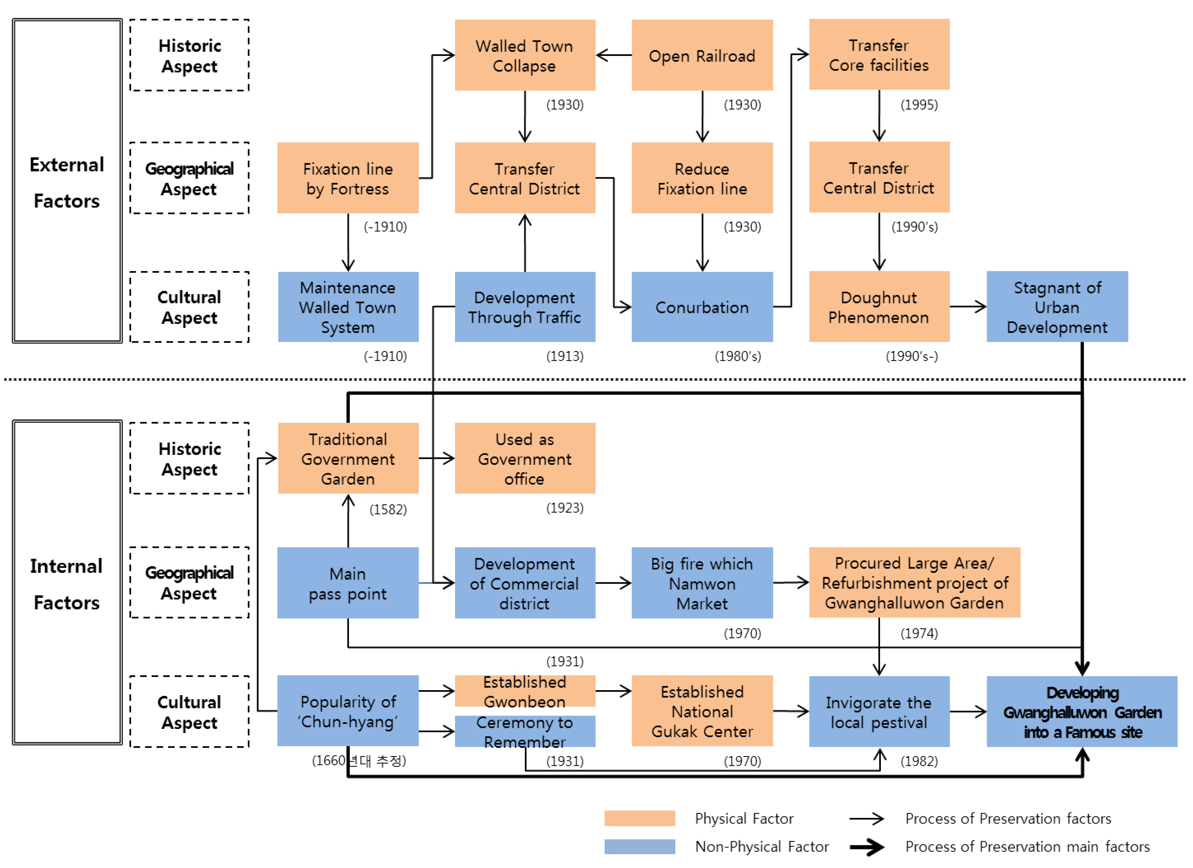
The factors that contributed to the conservation of Gwanghalluwon Garden as the “Dominated landscape” can be divided into external and internal factors. And, each factor has mutually related sub-factors in historic, cultural, and geographic aspects.
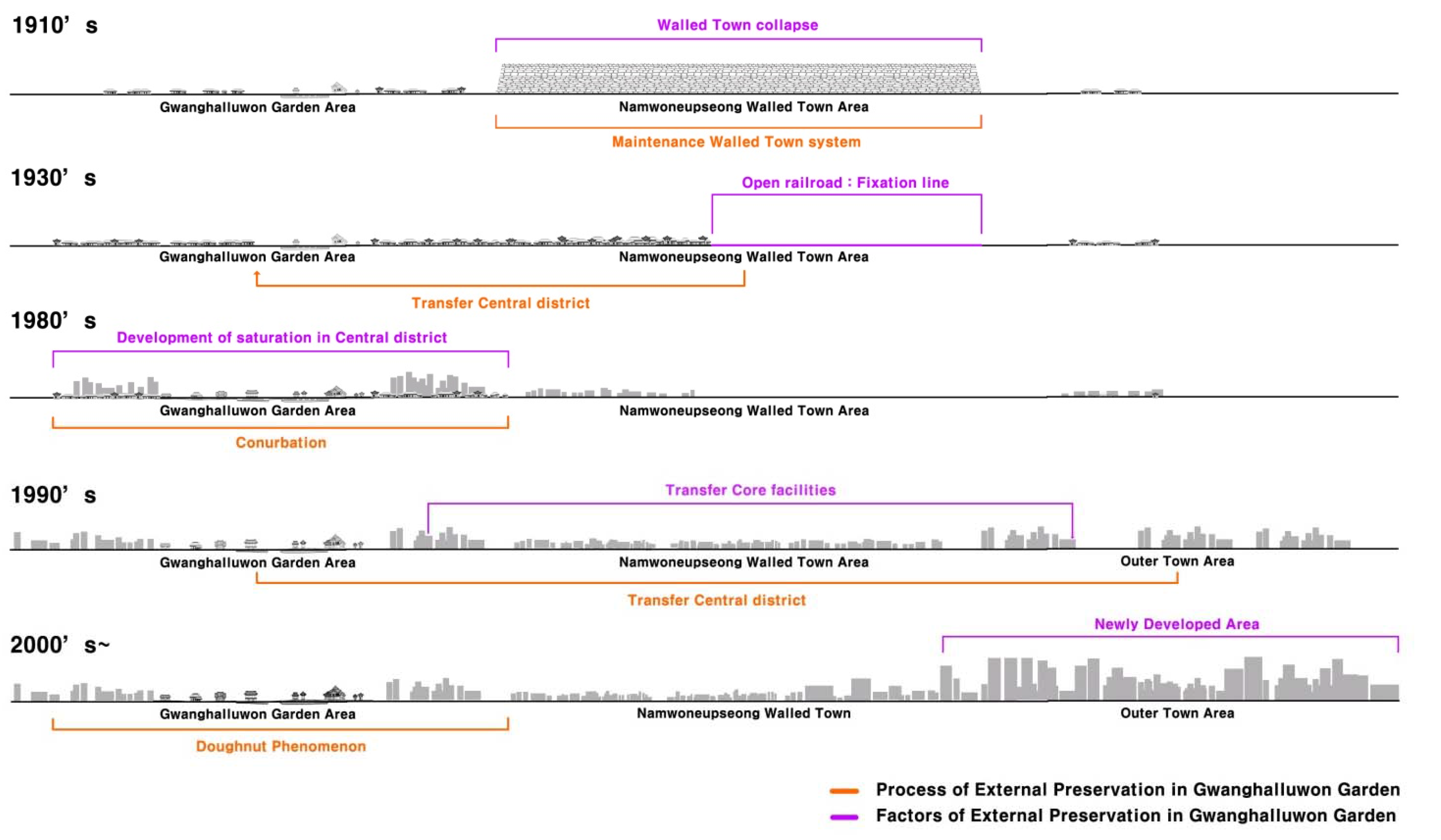
External factors contributing to Gwanghalluwon Garden’s preservation can be found in the fact that, as the area surrounding Gwanghalluwon Garden had been developed to a full extent, in the initial stage of urbanization of Namwon city, the central district had to move to outer areas, excluding the area surrounding Gwanghalluwon Garden from rapid changes of external landscape and pressures of further development (Figure 4).
During the Japanese colonial Period (1910–1945), as the walled town system with walls as its borders collapsed, Namwon city started to be urbanized. In 1913, as modern streets began to be built on the spaces where old city walls had been removed, the central districts moved out from the area inside the walls to Gwanghalluwon Garden. And, as railroad was constructed in the 1930s, the fixation line of Namwon city was restricted to the south of the railroad. Accordingly, before the urbanization of the 1980s started, the development of Gwanghalluwon Garden area had already become saturated, forcing the city government to choose conurbation, or expanding the urban development to the outskirts of the city. Then, as the expressway passing near the city was constructed in 1995, and the city hall and other core facilities moved to the newly developed area, Gwanghalluwon Garden area faced a doughnut phenomenon.
Figure 4. Process of External Preservation in Gwanghalluwon Garden. This figure was applied the methodology of the Nakamura Kazuo [16].
Sustainability 07 08565 g004
On the other hand, there have been some internal factors for the conservation of Gwanghalluwon Garden: use of it as administrative building (historical aspect), expansion of the area of Gwanghalluwon Garden (geographic aspect), and the popularity of the novel Chunhyang-jeon (cultural aspect). Gwanghalluwon Garden was built in 1434 as a pavilion, auxiliary to the city hall. During the Japanese Occupation Era, parts of Gwanghalluwon Garden and a considerable number of historic and cultural artifacts within it were damaged. But, it was used for administrative facilities such as the judicial court of Namwon city and a prison run by military police. In the modernization period, the pavilion was also used as temporary office buildings. That is the reason why Gwanghalluwon Garden could survive amid the changes of urban structures accompanying urban development of the city in the 1960s.
And, as the area surrounding Gwanghalluwon Garden-which is near Gurae and Sunchang cities to the south of it-has long been a transportation hub, it was developed as a commercial area after the Japanese Invasions of Joseon Dynasty (1592–1598). But, the big fire which occurred in Namwon Market in 1970 caused the area to lose its function as a commercial hub. Then, the Namwon municipal government procured large areas of land around Gwanghalluwon Garden, which added that land to Gwanghalluwon Garden’s total area. In 1974, the municipal government renovated Gwanghalluwon Garden itself to develop it as a tourist attraction. As the area of Gwanghalluwon Garden was expanded, a buffer zone between the Gwanghalluwon Garden space and the development area was formed. The revenue from the tourist area of Gwanghalluwon Garden contributed to the finances of the city government, so Gwanghalluwon Garden could be free from conflicts between development and conservation, forces frequently faced by the historical landscapes.
In addition, the popularity of the novel Chunhyang-jeon can be cited as a cultural factor contributing to the conservation of Gwanghalluwon Garden. In 1582, during the Joseon Dynasty, Gwanghalluwon Garden was equipped with Three Mysterious Groups of Islands, which symbolized the world of legendary hermits, and a pond. It became known as a beautiful site within the Joseon Dynasty. Chunhyang-jeon is a representative novel of the Joseon period and its stories are unfolded against the background of the beautiful landscape of Gwanghalluwon Garden. The romance and the main theme of the novel (that good ultimately triumphs over evil) was very popular among the people, making Gwanghalluwon Garden a popular place. Then, in 1931, Namwon Gwonbeon was established, and, in 1970, the National Gukak Center (Korean Classical Music Institute) was established in Gwanghalluwon Garden. Gwanghalluwon Garden was used as the stage for the Pansori (a Korean genre of musical storytelling) play, Chunhyang-ga. The ceremony to remember “Chunhyang”, which started in 1931, developed into a local festival with various themes and resources for tourists.
The secret of how Gwanghalluwon Garden has been able to survive as a “Dominated landscape” is likely to be found in the relationship between the development of the city (external factor), historical landscapes (internal factor), and complex interactions of history, geography, and culture, etc. And, each factor has served as a unique element in developing Gwanghalluwon Garden into a famous site. Now, people perceive the area surrounding Gwanghalluwon Garden as a valuable space (Figure 5).
Figure 5. Maintenance factors of Gwanghalluwon Garden.
Sustainability 07 08565 g005

3.4. Sustainability of the Area Surrounding Gwanghalluwon Garden

The sustainability that Gwanghalluwon Gardens has lies in the fact that it is a place where culture has accumulated over a long time, however it is threatened by urban development. To preserve Gwanghalluwon Garden’s important legacy as a historical landscape, it is necessary to shed new light on the awareness of values accumulated over time. Value awareness can be evaluated differently over time, and it has unpredictable variety. But, the awareness of respecting value and tradition of cultural spaces and natural environments has not diminished despite the long stream of time. Accordingly, the process by which a historical resource evolves in value, urban functions, and culture can be expected to have “unpredictable positive effects” where cultural acts occurring in areas like society, environment, and economics, etc. serve as motives to preserve the historical resource.
The UNESCO Recommendation promotes the Historic Urban Landscape (HUL) approach as a new way to include various aspects of conservation in an integrated framework, such as how cultural diversity affects values and approaches to conservation; the awareness of the link between natural and cultural factors in the conservation of the built environment; the new challenges brought about by rapid social and economic changes; and the need to ensure a sustainable future for heritage conservation. The HUL approach is not designed to replace existing doctrines or conservation approaches, but rather is envisaged as a tool to integrate policies and practices of conservation of the built environment by defining operational principles able to ensure urban conservation models that respect the values, traditions and environments of different cultural contexts, as well as to help redefine urban heritage as the centre of the spatial development process [17].
Steps to embody the approach for a historical city landscape are applied to the target places of this study as follows.

3.4.1. To Reach Consensus Using Participatory Planning and Stakeholder Consultations on What Values to Protect for Transmission to Future Generations and to Determine the Attributes that Carry these Values

When we consider its internal sustainability, we cannot ignore the effect of cultural tools, such as novels, traditional music called Pansori, and the garden surrounding the structure, which have functioned as internal borders. Furthermore, the construction of a natural environment of a fortress within the Garden made in accordance with feng-shui (the theory of divination based on topography) serves as a crucial element for the survival of Gwanghalluwon Garden. The retention of walled town as streets are part of the mass culture, which comprise Gwanghallu Pavilion, garden spaces, and the novel Chunhyang-jeon. Now, such places are used as leisure life spaces, and places where local festivals are held. The usage of these places for leisure and festival activities is the result of both current and past generations understanding their historic value as cultural properties. The recent trend of tourists preferring to enjoy traditional culture has contributed to an increase in visits to Gwanghalluwon Garden. The emergence of a link between a place which was part of Namwon city and that place being seen as a place for tourism serves as its external element. But, they can be contentious elements because there are conflicts of interests among various groups of people such as Namwon citizens and residents living near the old urban center, merchants in tourist districts, and tourists. Suitable compromises made between the leisure demands of Namwon citizens, demands of tourists, and demands of merchants in tourist districts should be the first priority in order to prevent them from tarnishing the essential value of Gwanghalluwon Garden.

3.4.2. To Integrate Urban Heritage Values and Their Vulnerability Status into a Wider Framework of City Development, which Shall Provide Indications of Areas of Heritage Sensitivity that Require Careful Attention to Planning, Design and Implementation of Development Projects

If we apply such phenomena to the area surrounding Gwanghalluwon Garden, it is to draw elements of perceiving values from external and internal aspects, and link them to other historical resources nearby in social, environmental, and cultural aspects. Through this process, we can recover the original form of Gwanghalluwon Garden.
From a social aspect, Namwon city’s Gwanghalluwon Garden still maintains some physical characteristics of street structure and a plane unit that was established in the period of the Three States. This means that the city still has a structural foundation for recovering the prototypes of the past. When value awareness for urban functions and culture enjoyment overlap, a high probability for sustainable development is possible.
Environmental aspects are divided into urban infrastructure, natural environment, and elements related with landmarks. The infrastructure before the demolition of the city walls is the element forming the image of the whole Namwon, and it is the object considered to be essential for recovering its original features. Its main structures have two fortresses, Namwoneupseong Walled Town and Gyoryongsanseong Fortress; Namwonhyanggyo Local Confucian School; and Gwanghalluwon Garden, entertainment facility that have remained until now. And, past landmarks―Seonwonsa temple (east), Gwanwangmyo shrine, Namwon (west), Gwanghalluwon Garden (south), and Gyoryongsanseong fortress (north)––are major elements which determine the four directions from the center of Namwon city, and can serve as standards determining the borders of the fortress.
Sustainability in cultural aspects has an overlapping relationship between cultural phenomenon perceived as an important element in the past and cultural value perception, which occurs nowadays. The past efforts to apply feng-shui (the theory of divination based on topography) and World of the Taoist concepts to geographic systems of the city were considered to be important values, serving as the momentum for historical resources to be able to survive up to now. The characteristics related with such concepts can be identified in the garden of Gwanghalluwon Garden, Seungwolgyo Bridge, and Seungwoldae Rock, and Gwanwangmyo Shrine, Namwon. Meanwhile, historical resources working as backgrounds for popular novels in the past such as Chunhyang-jeon (Gwanghalluwon Garden), Manboksa Jeopogi (Manboksa Temple site), and Hongdojeon (Tomb of Ten Thousand Patriotic Martyrs) are used as tourism themes related with story-telling, proving that historical resources have been preserved by changing them into sources of tourism.

3.4.3. To Prioritize Policies and Actions for Conservation and Development

Policies to preserve the area surrounding Gwanghalluwon Garden need to define the site based on values of the new age in order to secure its absolute value when such policies compete with other kinds of policies. In order to do that, proper value education, training, and perception, which can affect value decisions, caused by perception and culture formation on political, economic, and social importance should be secured. It is necessary to develop such cultural contents.

3.4.4. To Establish the Appropriate Partnerships and Local Management Frameworks for Each of the Identified Projects for Conservation and Development, as Well as to Develop Mechanisms for the Coordination of the Various Activities between Different Actors, both Public and Private

The examination of the awareness of value as a HUL mentioned above and a wider historical resources should be linked by fusing various awareness models as values evolve. To preserve Gwanghalluwon Garden’s sustainably, it is necessary to overlap values by linking values appearing per type in order to transcend social, economic, and political limits. Guided by the items suggested in the advice related with the “HUL” approach launched by UNESCO, joint examination of these issues by the committee consisting of the members of related agencies in the urban development project is necessary to reach an agreement on conservation of historic urban landscape considering its relationship with the project which is completes year by year. Therefore, national and local governments need to set up micro- and macro-goals and middle- and long-term goals for every stage of the urban development project, and long-term goals for recovering the original forms of historic urban landscape and activating it.
As seen in Figure 6, setting up of districts through linkage of different types of historical resources revealed that the area where values in various aspects overlapped the most is the district between the south and west border of the Namwon Eupseong walled town and Gwanghalluwon Garden. It is a residential area now suffering from Doughnut phenomenon. The district can be expected to serve as a buffer zone contributing to a recovery of the relationship between Namwon Eupseong walled town and Gwanghalluwon Garden. Through cultivating this area, the process of recovering sites where values are overlapped should be expanded.
Figure 6. Restoration network of Namwon walled town.
Sustainability 07 08565 g006

4. Conclusions

With Namwon City and Gwanghalluwon Garden as research objects, the present study examined the transitional process, in which the hierarchical dominance in the urban structure of Namwon City shifted from Namwon walled town to the area of Gwanghalluwon Garden, and its factors. The findings are as follows.
First, macroscopic analysis was conducted on the urban structure of Namwon City upon route system, urban pattern structure and urban pattern plane. The urban structure of past Namwon City had succeeded to the street structure of then-walled town. However, as through traffic developed in the urban, modified grid street structure coexisted with typical grid street structure in the land and the towns of the urban. In addition, as the fortress was demolished, limiting line to land development expanded east and west along the railroad and Yochun River. However, attention has returned to the activation of old downtown due to the saturation of development and urban hollowing out. The direction of new attention naturally steered to Gwanghalluwon Garden located in the old downtown.
Second, the microscope analysis was carried out on the whole area of Gwanghalluwon Garden. The changes in the lots in the cadastral map data showed that the garden, which was originally a government office pavilion, started to possess the characteristics of a tourist attraction with Chunhyang as its theme. It was transformed into the current figure of Gwanghalluwon Garden through the regional expansion project in the 1960s, relocation due to the fire accident in the neighboring market in the 1970s and a large-scaled land purchase of Namwon County. Later, Gwanghalluwon Garden was designated as a cultural asset and the current shape of Gwanghalluwon Garden has been preserved since then.
Third, external factor contributing to Gwanghalluwon Garden’s preservation can be found in the fact that, as the area surrounding Gwanghalluwon Garden had been developed to a full extent, in the initial stage of urbanization of Namwon city, excluding the area surrounding Gwanghalluwon Garden from rapid changes of external landscape and pressures of further development. On the other hand, there have been some internal factors for the conservation of Gwanghalluwon Garden: use of it as administrative building (historical aspect), expansion of the area of Gwanghalluwon Garden (geographic aspect), and the popularity of the novel Chunhyang-jeon (cultural aspect).
Fourth, to preserve Gwanghalluwon Garden’s important legacy as a historical landscape, it is necessary to shed new light on the awareness of values accumulated over time. Accordingly, the process by which a historical resource evolves in value, urban functions, and culture can be expected to have “unpredictable positive effects” where cultural acts occurring in areas like society, environment, and economics, etc. serve as motives to preserve the historical resource.
In the past, a historical continuity was often disregarded for modernization in eastern society. And preserving the cultural assets within the historical landscapes has depended only on preserving the original form with no concern for the social situation. However, now, as a matter of history, in terms of preserving the principal value of an object, which can be affected by other factors, it is important to consider not only direct impact of the object itself, but also various external factors. Preservation of the main value of a particular object is not obtained by solely focusing on direct factors and effects but by also considering those factors which are indirect. A multilateral effort is necessary, which includes tracing the changes of growth and development through history, as well as factoring changes in society, both at the local and national level.

Acknowledgments

We would like to thank the two anonymous referees for their helpful comments.

Author Contributions

Hyun Sil Shin, Yaohua Chen, Won Ho Lee and Dong Hyun Kim work together. Specifically, the first author Hyun Sil Shin wrote the paper and designed the research. The second author and corresponding author Yaohua chen co-designed the reseach and made detailed revisions. The third author Won Ho Lee brings the ideas, quide the experiments, and conducts the organization of the content and gives proposal about the study. The fourth author Dong Hyun Kim carries out the main experiments of measuring the Namwon city and Gwanghalluwon garden transition and gives some analysis of the results. All authors have read and approved the final manuscript.

Conflicts of Interest

The authors declare no conflict of interest.

References

  1. United Nations Environment Programme National Committee for the Republic of Korea. Available online: http://www.unep.or.kr/sub/sub05_01.php?mNum=5&sNum=1&boardid=planet&mode=view&idx=234 (accessed on 22 November 2005).
  2. Kuban, D. Toward an Architecture in the Spirit of Islam; The Aga Khan Award for Architecture: Philadelphia, PA, USA, 1978. [Google Scholar]
  3. Lee, H.J. A Study on the Management around Cultural Properties for Historic Landscape Conservation; University of Seoul Press: Seoul, Korea, 2003. [Google Scholar]
  4. Kim, B.S. A Study on the Cultural Heritage Policy Network of Yeincheon-gun in Korea; University of Seoul Press: Seoul, Korea, 2012. [Google Scholar]
  5. Guenzel, S. Topologie; Transcript Verlag Publisher: Bielefeld, Germany, 2013. [Google Scholar]
  6. Ryu, E.K.; Park, C.S. A Preliminary Study on the Characteristic for Spatial Organization in NAMWON EUPSEONG––In the Community Facilities and Spatial Organization. J. Korea Plan. Assoc. 1997, 23, 61–73. [Google Scholar]
  7. Masayuki, S. A Creative City; Sohwa Publication: Seoul, Korea, 2004. [Google Scholar]
  8. Lee, K.C. Transformational Characteristics of Plot System in the Urban Spatial Structure; Seoul National University Press: Seoul, Korea, 1992. [Google Scholar]
  9. Yang, S.W. A Study on the Type of Urban Tissue of Seoul in the Late Choseon Dynasty; Seoul National University Press: Seoul, Korea, 1994. [Google Scholar]
  10. Namwon City Hall Homepage. Available online: http://www.namwon.go.kr/index.nwn?contentUid=ff808081414a8cb701414d947638017c (accessed on 29 June 2015).
  11. Clay, G. Close-Up-How to Read the American City; The University of Chicago Press: Chicago, IL, USA, 1980. [Google Scholar]
  12. Park, Y.S. Gwanghancheongherbu in Namwon. Korea Spat. Plan. Rev. 2009, 334, 149. [Google Scholar]
  13. Kang, G.O. The Monthly News Korea. Available online: http://www.k-today.com/news/articleView.html?idxno=118 (accessed on 13 December 2013).
  14. Lee, W.H.; Kim, D.H.; Kim, J.U.; Ahn., H.I.; Kim, D.Y.; Cho, U.Y. A Study on the aspect of landscape change for Gwanghalluwon Garden. J. Korean Inst. Tradit. Landsc. Archit. 2014, 32, 82–94. [Google Scholar]
  15. Namwon Cultural Council. History of Yong Sung; Namwon Cultural Council: Namwon, Korea, 1995. [Google Scholar]
  16. Kazuo, N. Regional and Landscape; Sunhaksa: Sungnam, Korea, 2001. [Google Scholar]
  17. Rao, K. The Historic Urban Landscape Approach. In Proceedings of the UNESCO Asia-Pacific Mayor’s Forum for World Heritage Cities, Gyeongju, Korea, 29–30 August 2012; UNESCO: Seoul, Korea, 2012; pp. 15–24. [Google Scholar]

