Atmospheric and Radiometric Correction Algorithms for the Multitemporal Assessment of Grasslands Productivity

 ,
,  and
and
Abstract
:
1. Introduction
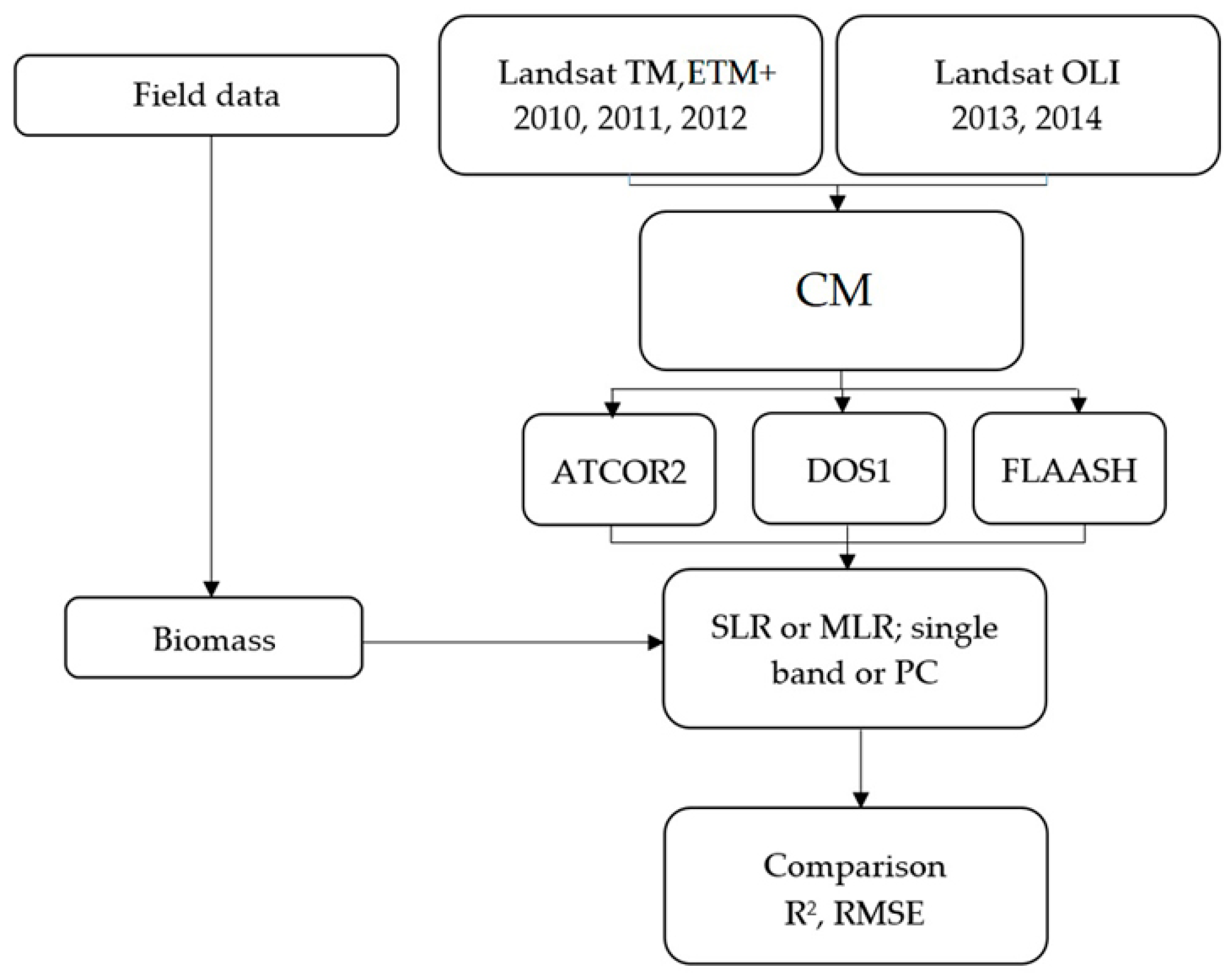
2. Materials and Methods
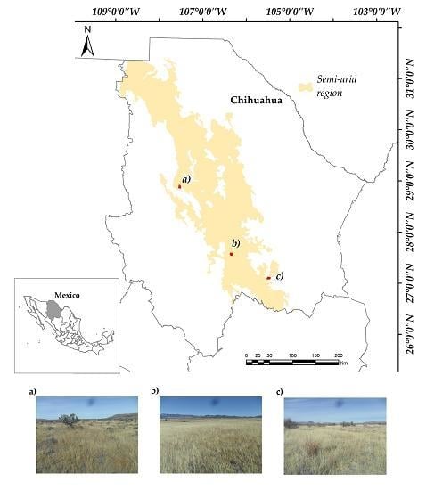
2.1. Study Area
2.2. Biomass Sampling
2.3. Satellite Data
2.4. Correction Methods
2.5. Accuracy of the Correction Methods
3. Results
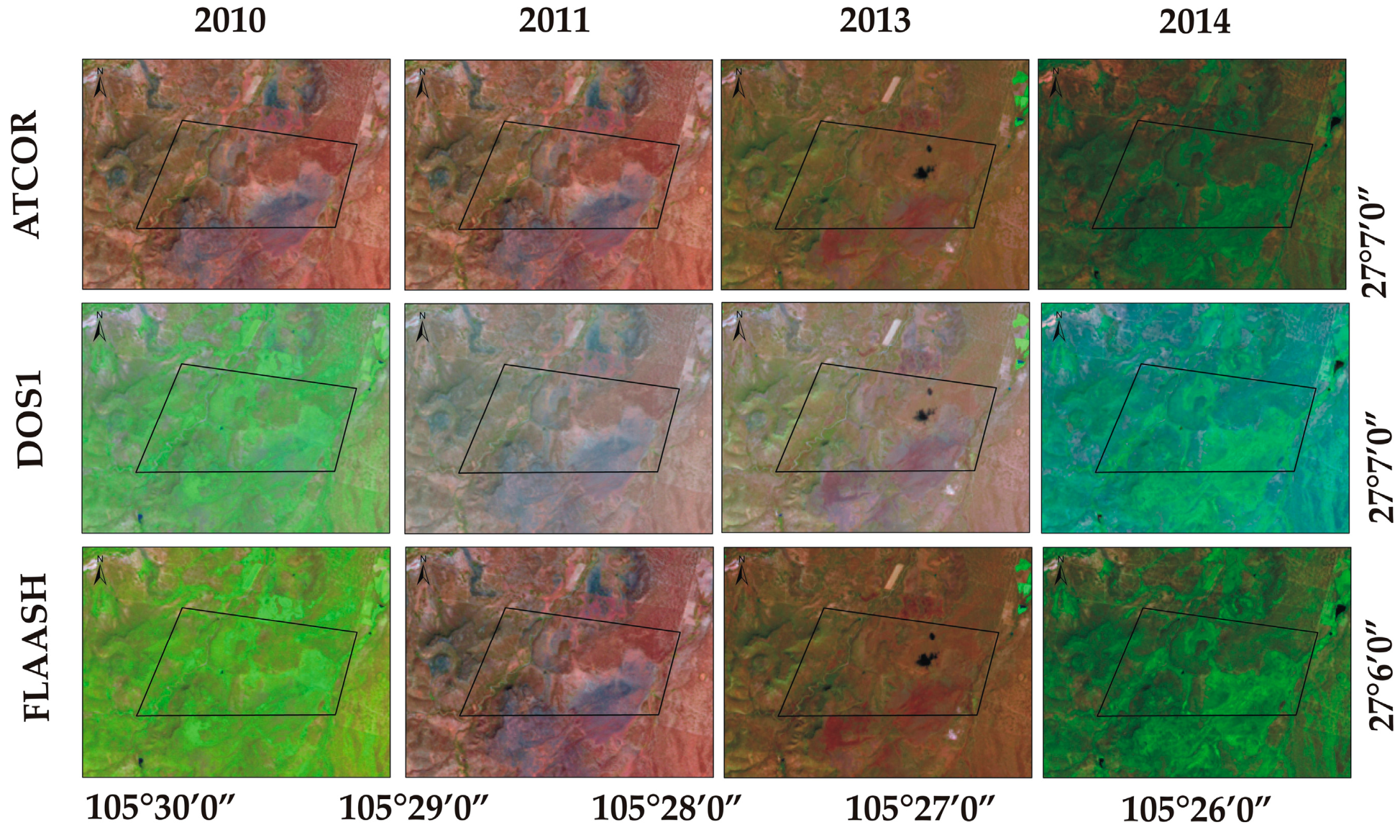
3.1. Composition of Radiometrically Corrected Images
3.2. Comparative Analysis of the Correction Methods
3.3. Estimated Annual Biomass
4. Discussion
5. Conclusions
Acknowledgments
Author Contributions
Conflicts of Interest
References
- Yang, Y.; Fang, J.; Pan, Y.; Ji, C. Aboveground biomass in Tibetan grasslands. J. Arid Environ. 2009, 73, 91–95. [Google Scholar] [CrossRef]
- Jin, Y.X.; Yang, X.C.; Qiu, J.J.; Li, J.Y.; Gao, T.; Wu, Q.; Zhao, F.; Ma, H.L.; Yu, H.D.; Xu, B. Remote sensing-based biomass estimation and its spatio-temporal variations in temperate grassland, Northern China. Remote Sens. 2014, 6, 1496–1513. [Google Scholar] [CrossRef]
- Craine, J.M. Long-term climate sensitivity of grazer performance: A cross-site study. PLoS ONE 2013, 8, e67065. [Google Scholar] [CrossRef] [PubMed]
- Manjarrez-Domínguez, C.; Pinedo-Alvarez, A.; Pinedo-Alvarez, C.; Villarreal-Guerrero, F.; Cortes-Palacios, L. Vegetation landscape analysis due to land use changes on arid lands. Pol. J. Ecol. 2015, 63, 272–279. [Google Scholar] [CrossRef]
- Estrada-Castillón, E.; Scott-Morales, L.; Villarreal-Quintanilla, J.A.; Jurado-Ybarra, E.; Cotera-Correa, M.; Cantú-Ayala, C.; García-Pérez, J. Clasificación de los pastizales halófilos del noreste de México asociados con perrito de las praderas (Cynomys mexicanus): Diversidad y endemismo de especies. Revista Mexicana de Biodiversidad 2010, 81, 401–416. [Google Scholar]
- He, C.; Zhang, Q.; Li, Y.; Li, X.; Shi, P. Zoning grassland protection area using remote sensing and cellular automata modeling-A case study in Xilingol steppe grassland in northern China. J. Arid Environ. 2005, 63, 814–826. [Google Scholar] [CrossRef]
- Fan, J.W.; Zhong, H.P.; Harris, W.; Yu, G.R.; Wang, S.Q.; Hu, Z.M.; Yue, Y.Z. Carbon storage in the grassland of China based on field measurement of above- and below- ground biomass. Clim. Chang. 2007, 86, 375–396. [Google Scholar] [CrossRef]
- Ruppert, J.C.; Linstädter, A. Convergence between ANPP estimation methods in grasslands—A practical solution to the comparability dilemma. Ecol. Indic. 2014, 36, 524–531. [Google Scholar] [CrossRef]
- Xie, Y.C.; Sha, Z.Y.; Yu, M.; Bai, Y.F.; Zhang, L. A comparison of two models with Landsat data for estimating above ground grassland biomass in Inner Mongolia, China. Ecol. Model. 2009, 220, 1810–1818. [Google Scholar] [CrossRef]
- Goetz, S.J.; Prince, S.D.; Goward, S.N.; Thawley, M.M.; Small, J. Satellite remote sensing of primary production: An improved production efficiency modeling approach. Ecol. Model. 1999, 122, 239–255. [Google Scholar] [CrossRef]
- Li, J.Y.; Yang, X.C.; Jin, Y.X.; Yang, Z.; Huang, W.G.; Zhao, L.N.; Gao, T.; Yu, H.D.; Ma, H.L.; Qin, Z.H.; et al. Monitoring and analysis of grassland desertification dynamics using Landsat images in Ningxia, China. Remote Sens. Environ. 2003, 138, 19–26. [Google Scholar] [CrossRef]
- Zhao, P.; Dengsheng, L.; Guangxing, W.; Chuping, W.; Yujie, H.; Shuquan, Y. Examining spectral reflectance saturation in Landsat imagery and corresponding solutions to improve forest aboveground biomass estimation. Remote Sens. 2016, 8, 469. [Google Scholar] [CrossRef]
- Naesset, E.; Gobakken, T.; Bollandsås, O.M.; Gregoire, T.G.; Nelson, R.; Ståhl, G. Comparison of precision of biomass estimates in regional field sample surveys and airborne LiDAR-assisted surveys in Hedmark County, Norway. Remote Sens. Environ. 2013, 130, 108–120. [Google Scholar] [CrossRef]
- Schino, G.; Borfecchia, F.; De Cecco, L. Satellite estimate of grass biomass in a mountainous range in central Italy. Agrofor. Syst. 2003, 59, 157–162. [Google Scholar] [CrossRef]
- Marsett, C.R.; Qi, J.; Heilman, P.; Biedenbender, H.S.; Watson, C.M.; Amer, S.; Weltz, M.; Goodrich, D.; Marsett, R. Remote sensing for grassland management in the arid Southwest. Rangel. Ecol. Manag. 2006, 59, 530–540. [Google Scholar] [CrossRef]
- Dusseux, P.; Huber-Moy, L.; Corpetti, T.; Vertès, F. Evaluation of SPOT imagery for the estimation of grassland biomass. Int. J. Appl. Earth Obs. 2015, 38, 72–77. [Google Scholar] [CrossRef]
- Rodríguez-Maturino, A.; Martínez-Guerrero, J.H.; Chairez-Hernández, I.; Pereda-Solis, M.E.; Villarreal-Guerrero, F.; Renteria-Villalobos, M.; Pinedo-Alvarez, A. Mapping land cover and estimating the grassland structure in a priority area of the Chihuahuan desert. Land 2017, 6, 70. [Google Scholar] [CrossRef]
- Cohen, W.B.; Goward, S.N. Landsat’s role in ecological applications of remote sensing. BioScience 2004, 54, 535–545. [Google Scholar] [CrossRef]
- Woodcock, C.E.; Macomber, S.A.; Pax-Lenney, M.; Cohen, W.C. Monitoring large areas for forest change using Landsat: Generalization across space, time and Landsat sensors. Remote Sens. Environ. 2001, 78, 194–203. [Google Scholar] [CrossRef]
- Wulder, M.A.; White, J.C.; Goward, S.N.; Masek, J.G.; Irons, J.R.; Herold, M.; Cohen, W.B.; Loveland, T.R.; Woodcock, C.E. Landsat continuity: Issues and opportunities for land cover monitoring. Remote Sens. Environ. 2008, 112, 955–969. [Google Scholar] [CrossRef]
- Hansen, M.C.; Loveland, T.R. A review of large are monitoring of land cover change using Landsat data. Remote Sens. Environ. 2012, 122, 66–74. [Google Scholar] [CrossRef]
- Chander, G.; Markham, B.L.; Helder, D.L. Summary of current radiometric calibration coefficients for Landsat MSS, TM, ETM+, and EO-1 ALI sensors. Remote Sens. Environ. 2009, 113, 893–903. [Google Scholar] [CrossRef]
- Tan, K.C.; San Lim, H.; MatJafri, M.Z.; Abdullah, K. A comparison of radiometric correction techniques in the evaluation of the relationship between LST and NDVI in Landsat imagery. Environ. Monit. Assess. 2012, 184, 3813–3829. [Google Scholar] [CrossRef] [PubMed]
- Roy, D.P.; Zhang, H.K.; Ju, J.; Gomez-Dans, J.L.; Lewis, P.E.; Schaaf, C.B.; Sun, Q.; Li, J.; Hung, H.; Kovalskyy, V. A general method to normalized Landsat reflectance data to nadir BRDF adjusted reflectance. Remote Sens. Environ. 2016, 176, 255–271. [Google Scholar] [CrossRef]
- Körner, I.; Oreopoulos, L.; Feingold, G.; Remer, L.A.; Altaratz, O. How small is a small cloud? Atmos. Chem. Phys. 2008, 8, 3855–3864. [Google Scholar] [CrossRef]
- Zelazowski, P.; Sayer, A.M.; Thomas, G.E.; Grainger, R.G. Reconciling satellite-derived atmospheric properties with fine-resolution land imagery: Insights for atmospheric correction. J. Geophys Res. Atmos. 2011, 116. [Google Scholar] [CrossRef]
- Pons, X.; Pesquer, L.; Cristóbal, J.; González-Guerrero, O. Automatic and improved radiometric correction of Landsat imagery using reference values from MODIS surface reflectance images. Int. J. Appl. Earth. Obs. 2014, 33, 243–254. [Google Scholar] [CrossRef]
- Pinedo, A.C.; Pinedo, A.A.; Martinez, Q.R.M. Análisis de áreas deforestadas en la región centro-norte de la Sierra Madre Occidental, Chihuahua, México. Tecnociencia Chihuah. 2007, 1, 36–43. [Google Scholar]
- Vázquez-Quintero, G.; Solís-Moreno, R.; Pompa-García, M.; Villarreal-Guerrero, F.; Pinedo-Alvarez, C.; Pinedo-Alvarez, A. Detection and projection of forest changes by using the Markov Chain Model and Cellular Automata. Sustainability 2016, 8, 236. [Google Scholar] [CrossRef]
- Prieto-Amparán, J.A.; Pinedo-Alvarez, A.; Villarreal-Guerrero, F.; Pinedo-Alvarez, C.; Morales-Nieto, C.; Manjarrez-Domínguez, C. Past and future spatial growth dynamics of Chihuahua city, Mexico: Pressures for land use. ISPRS Int. Geo-Inf. 2016, 5, 235. [Google Scholar] [CrossRef]
- Chavez, P.S., Jr. An improved dark-object subtraction technique for atmospheric scattering correction of multispectral data. Remote Sens. Environ. 1988, 24, 459–479. [Google Scholar] [CrossRef]
- Kaufman, Y.J.; Wald, A.E.; Remer, L.A.; Gao, B.C.; Li, R.-R.; Flynn, L. The MODIS 2.1-um channel-correlation with visible reflectance for use in remote sensing of aerosol. IEEE Trans. Geosci. Remote Sens. 1997, 35, 1286–1298. [Google Scholar] [CrossRef]
- Janzen, T.D.; Fredeen, L.A.; Wheate, D.R. Radiometric correction techniques and accuracy assessment for Landsat TM data in remote forested regions. Can. J. Remote Sens. 2006, 32, 330–340. [Google Scholar] [CrossRef]
- Lyapustin, A.; Williams, D.L.; Markham, B.; Irons, J.; Holben, B.; Wang, Y. A method for unbiased high-resolution aerosol retrieval from Landsat. J. Atmos. Sci. 2004, 61, 1233–1244. [Google Scholar] [CrossRef]
- Richter, R.; Schlapfer, D.; Muller, A. An automatic atmospheric correction algorithm for visible/NIR imagery. Int. J. Remote Sens. 2006, 27, 2077–2085. [Google Scholar] [CrossRef]
- Kruse, F.A. Comparison of ATREM, ACORN, and FLAASH atmospheric corrections using low-altitude AVIRIS data of Boulder, CO. In Proceedings of the 13th JPL Airborne Geoscicence Workshop, Pasadena, CA, USA, 31 March–2 April 2004. [Google Scholar]
- Neubert, M.; Meinel, G. Atmospheric and terrain correction of IKONOS imagery using ATCOR3. In Proceedings of the ISPRS Workshop 2005: High-Resolution Earth Imaging for Geospatial Information, Hannover, Germany, 17–20 May 2005. [Google Scholar]
- Geosystems. Haze Reduction, Atmospheric and Topographic Correction. User Manual ATCOR2 and ATCOR3; Geosystems GmbH: Geneva, Switzerland, 2013. [Google Scholar]
- Paolini, L.; Grings, F.; Sobrino, J.A.; Jiménez Muñoz, J.C.; Karszenbaum, H. Radiometric correction effects in Landsat multi-date/multi-sensor change detection studies. Int. J. Remote Sens. 2006, 27, 685–704. [Google Scholar] [CrossRef]
- Cui, Q.Y.; Gaillard, M.J.; Lemdahl, G.; Stenberg, L.; Sugita, S.; Zernova, G. Historical land-use and landscape change in Southern Sweden and implications for present and future biodiversity. Ecol. Evol. 2014, 4, 3555–3570. [Google Scholar] [CrossRef] [PubMed]
- El Hajj, M.; Bégué, A.; Lafrance, B.; Hagolle, O.; Dedieu, G.; Rumeau, M. Relative radiometric normalization and atmospheric correction of a SPOT 5 time series. Sensors 2008, 8, 2774–2791. [Google Scholar] [CrossRef] [PubMed]
- Chang, J.; Clay, D.E.; Leigh, L.; Aaron, D.; Dalsted, K.; Volz, M. Evaluating modified atmospheric correction methods for Landsat Imagery: Image-based and model-based calibration methods. Commun. Soil Sci. Plan. 2008, 39, 1532–1545. [Google Scholar] [CrossRef]
- Callieco, F.; Dell’Acqua, F. A comparison between two radiative transfer models for atmospheric correction over a wide range of wavelengths. Int. J. Remote Sens. 2011, 32, 1357–1370. [Google Scholar] [CrossRef]
- Agrawal, G.; Sarup, J.; Bhopal, M. Comparision of QUAC and FLAASH atmospheric correction modules on EO-1 Hyperion data of Sanchi. Int. J. Adv. Eng. Sci. Technol. 2011, 4, 178–186. [Google Scholar]
- Nazeer, M.; Nichol, J.E.; Yung, Y.K. Evaluation of atmospheric correction models and Landsat surface reflectance product in an urban coastal environment. Int. J. Remote Sens. 2014, 35, 6271–6291. [Google Scholar] [CrossRef]
- López-Serrano, P.M.; Corral-Rivas, J.J.; Díaz-Varela, R.A.; Álvarez-González, J.G.; López-Sánchez, C.A. Evaluation of radiometric and atmospheric correction algorithms for aboveground forest biomass estimation using Landsat 5 TM data. Remote Sens. 2016, 8, 369. [Google Scholar] [CrossRef]
- Martins, V.S.; Barbosa, C.C.F.; de Carvalho, L.A.S.; Jorge, D.S.F.; Lobo, F.D.L.; Novo, E.M.L.D.M. Assessment of atmospheric correction methods for Sentinel-2 MSI images applied to Amazon floodplain lakes. Remote Sens. 2017, 9, 322. [Google Scholar] [CrossRef]
- Vicente-Serrano, S.M.; Pérez-Cabello, F.; Lasanta, T. Assessment of radiometric correction techniques in analyzing vegetation variability and change using time series of Landsat images. Remote Sens. Environ. 2008, 112, 3916–3934. [Google Scholar] [CrossRef]
- Nguyen, H.C.; Jung, J.; Lee, J.; Choi, S.U.; Hong, S.Y.; Heo, J. Optimal atmospheric correction for above-ground forest biomass estimation with the ETM+ remote sensor. Sensors 2015, 15, 18865–18886. [Google Scholar] [CrossRef] [PubMed]
- Raab, C.; Barrett, B.; Cawkwell, F.; Green, S. Evaluation of multi-temporal and multi-sensor atmospheric correction strategies for land-cover accounting and monitoring in Ireland. Remote Sens. Lett. 2015, 6, 784–793. [Google Scholar] [CrossRef]
- CGG-SAGARPA; COLPOS. Manual de Campo Para la Red Básica del Sistema Nacional de Monitoreo Terrestre Orientado a la Ganadería; Coordinación General de Ganadería de la Secretaria de Agricultura, Ganadería, Desarrollo Rural, Pesca y Alimentación: Distrito Federral, Mexico, 2009. [Google Scholar]
- CONABIO (Comisión Nacional para el Conocimiento y Uso de la Biodiversidad). La Biodiversidad en Chihuahua: Estudio de Estado; Comisión Nacional para el Conocimiento y Uso de la Biodiversidad: Distrito Federral, Mexico, 2014.
- Jurado, G.P.; Saucedo, T.R.A.; Morales, N.C.R.; Martínez, S.M. Almacén y Captura de Carbono en Pastizales y Matorrales de Chihuahua; INIFAP: Chihuahua, Mexico, 2013. [Google Scholar]
- Samson, F.B.; Knopf, F.L.; Ostlie, W.R. Great Plains ecosystems: Past, present, and future. Wildl. Soc. Bull. 2004, 32, 6–15. [Google Scholar] [CrossRef]
- IUCN (International Union for Conservation of Nature). Available online: http://www.iucnredlist.org/details/18868/0 (accessed on 20 November 2016).
- Ni, J. Estimating net primary productivity of grasslands from field biomass measurements in temperate northern China. Plant Ecol. 2004, 174, 217–234. [Google Scholar] [CrossRef]
- United States Geological Survey. Available online: http://glovis.usgs.gov (accessed on 20 June 2016).
- Barsi, J.A.; Lee, K.; Kvaran, G.; Markham, B.L.; Pedelty, J.A. The spectral response of the Landsat-8 operational land imager. Remote Sens. 2014, 6, 10232–10251. [Google Scholar] [CrossRef]
- Berk, A.; Bernstein, L.S.; Anderson, G.P.; Acharya, P.K.; Robertson, D.C.; Chetwynd, J.H.; Adler-Golden, S.M. MODTRAN cloud and multiple scattering upgrades with application to AVIRIS. Remote Sens. Environ. 1998, 65, 367–375. [Google Scholar] [CrossRef]
- Marcello, J.; Eugenio, F.; Perdomo, U.; Medina, A. Assessment of atmospheric algorithms to retrieve vegetation in natural protected areas using multispectral high resolution imagery. Sensors 2016, 16, 1624. [Google Scholar] [CrossRef] [PubMed]
- Adler-Golden, S.; Berk, A.; Bernstein, L.S.; Richtsmeier, S.; Acharya, P.K.; Matthew, M.W.; Chetwynd, J.H. FLAASH, A MODTRAN4 atmospheric correction package for hyperspectral data retrievals and simulations. In Proceedings of the 7th Annal JPL Airborne Earth Science Workshop, Pasadena, CA, USA, 4–8 March 1998; pp. 9–14. [Google Scholar]
- Anderson, G.P.; Felde, G.W.; Hoke, M.L.; Ratkowski, A.J.; Cooley, T.W.; Chetwynd, J.H.; Bernstein, L.S. MODTRAN4-based atmospheric correction algorithm: FLAASH (Fast Line-of-sight Atmospheric Analysis of Spectral Hypercubes. In Algorithms and Technologies for Multispectral, Hyperspectral, and Ultraspectral Imagery VIII; Society of Photo Optics: Orlando, FL, USA, 2002; Volume 4725, pp. 65–72. [Google Scholar]
- Congedo, L. Semi-Automatic Classification Plugin for QGIS; Technical Report; Sapienza University, ACC Dar Project: Rome, Italy, 2013. [Google Scholar]
- Lu, D.; Mausel, P.; Brondizio, E.; Moran, E. Assessment of atmospheric correction methods for Landsat TM data applicable to Amazon basin LBA research. Int. J. Remote Sens. 2002, 23, 2651–2671. [Google Scholar] [CrossRef]
- Manakos, I.; Manevski, K.; Kalaitzidis, C.; Edler, D. Comparison between atmospheric correction modules on the basis of Worldview-2 imagery and in situ spectroradiometric measurements. In Proceedings of the 7th EARSeL Workshop on Imaging Spectroscopy, Edinburgh, UK, 11–13 April 2011; pp. 1–12. [Google Scholar]
- Chavez, P.S. Image-based atmospheric corrections revisited and improved. Photogramm. Eng. Remote Sens. 1996, 62, 1025–1036. [Google Scholar]
- Matthew, M.W.; Adler-Golden, S.M.; Berk, A.; Richtsmeier, S.C.; Levine, R.Y.; Bernstein, L.S.; Acharya, P.K.; Anderson, G.P.; Felde, G.W.; Hoke, M.P. Status of atmospheric correction using a MODTRAN4-based algorithm. In Proceedings of the Algorithms for Multispectral, Hyperspectral, and Ultraspectral Imagery VI, Orlando, FL, USA, 24–26 April 2000; pp. 199–207. [Google Scholar]
- Hadjimitsis, D.G.; Clayton, C.R.I.; Hope, V.S. An assessment of the effectiveness of atmospheric correction algorithms through the remote sensing of some reservoirs. Int. J. Remote Sens. 2004, 25, 3651–3674. [Google Scholar] [CrossRef]
- Song, C.; Woodcock, C.E.; Seto, K.C.; Lenney, M.P.; Macomber, S.A. Classification and change detection using Landsat TM data: When and how to correct atmospheric effects? Remote Sens. Environ. 2001, 75, 230–244. [Google Scholar] [CrossRef]
- Liang, S.; Fang, H.; Morisette, J.T.; Chen, M.; Shuey, C.J.; Walthall, C.L.; Daughtry, C.S. Atmospheric correction of Landsat ETM+ land surface imagery. II. Validation and applications. IEEE Trans. Geosci. Remote Sens. 2002, 40, 2736–2746. [Google Scholar] [CrossRef]
- Mahiny, A.S.; Turner, B.J. A comparison of four common atmospheric correction methods. Photogramm. Eng. Remote Sens. 2007, 73, 361–368. [Google Scholar] [CrossRef]
- Mason, S.; Kruczkiewicz, A.; Ceccato, P.; Crawford, A. Accessing and Using Climate Data and Information in Fragile, Data-Poor States; International Institute for Sustainable Development: Winnipeg, MB, Canada, 2015. [Google Scholar]
- Wu, J.; Wang, D.; Bauer, M.E. Image-based atmospheric correction of QuickBird imagery of Minnesota cropland. Remote Sens. Environ. 2005, 99, 315–325. [Google Scholar] [CrossRef]
- Chuvieco, E.; Aguado, I.; Yebra, M.; Nieto, H.; Salas, J.; Pilar, M.M.; Vilar, L.; Martínez, J.; Martin, S.; Ibarra, P.; et al. Development of a framework for fire risk assessment using remote sensing and geographic information system technologies. Ecol. Model. 2010, 221, 46–58. [Google Scholar] [CrossRef]
- Sonobe, R.; Yamaya, Y.; Tani, H.; Wang, X.; Kobayashi, N.; Mochizuki, K. Mapping crop cover using multi-temporal Landsat 8 OLI imagery. Int. J. Remote Sens. 2017, 38, 4348–4361. [Google Scholar] [CrossRef]
- Yan, J.; Zhu, C.; Liu, W.; Luo, F.; Mi, J.; Ren, Y.; Li, J.; Sang, T. High photosynthetic rate and water use efficiency of Miscanthus lutarioriparius characterize an energy crop in the semiarid temperate region. GCB Bioenergy 2015, 7, 207–218. [Google Scholar] [CrossRef]
- Roy, P.S.; Ravan, S.A. Biomass estimation using satellite remote sensing data—An investigation on possible approaches for natural forest. J. Biosci. 1996, 21, 535–561. [Google Scholar] [CrossRef]
- Schroeder, T.A.; Cohen, W.B.; Song, C.; Canty, M.J.; Yang, Z. Radiometric correction of multi-temporal Landsat data for characterization of early successional forest patterns in western Oregon. Remote Sens. Environ. 2006, 103, 16–26. [Google Scholar] [CrossRef]


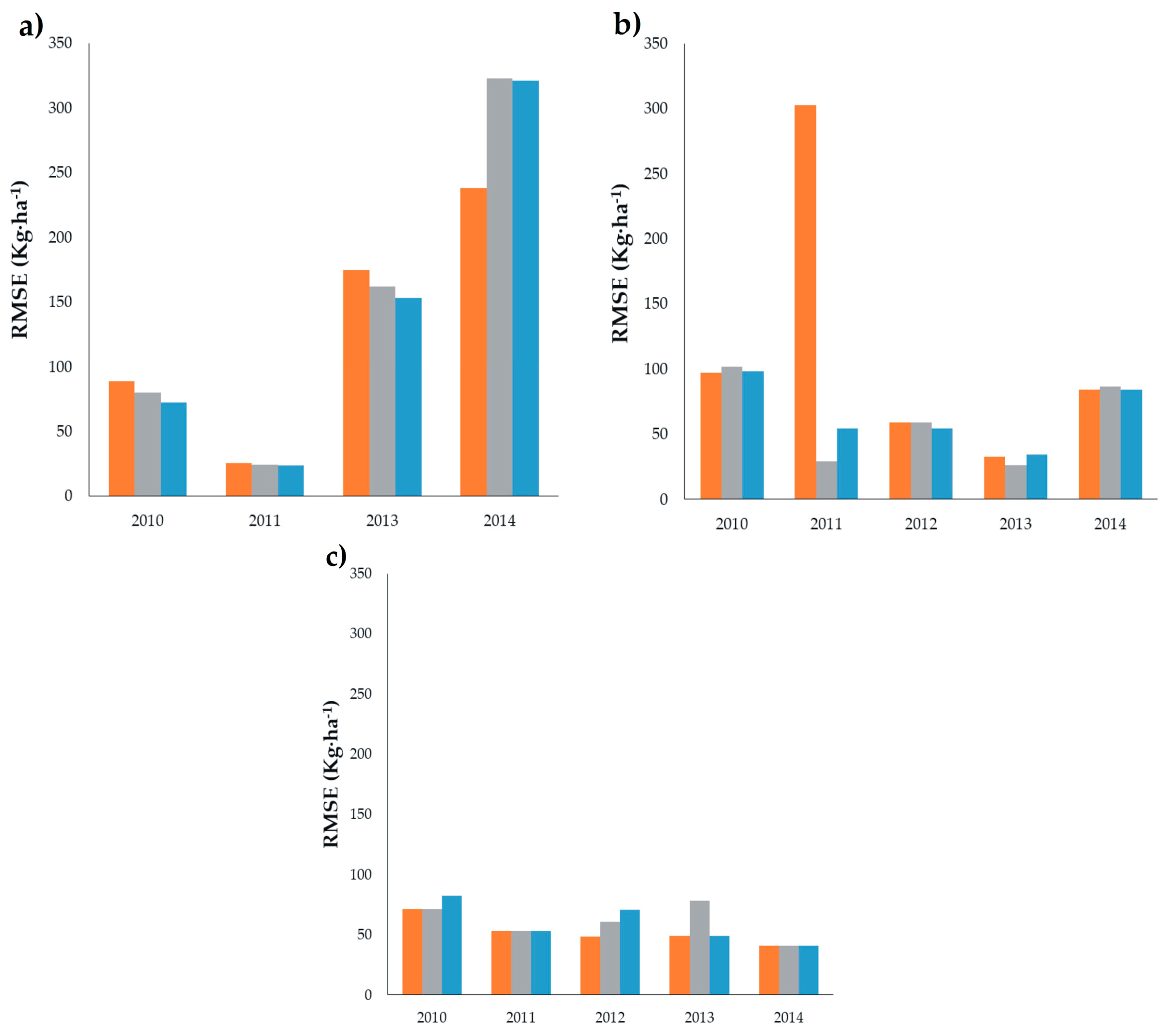
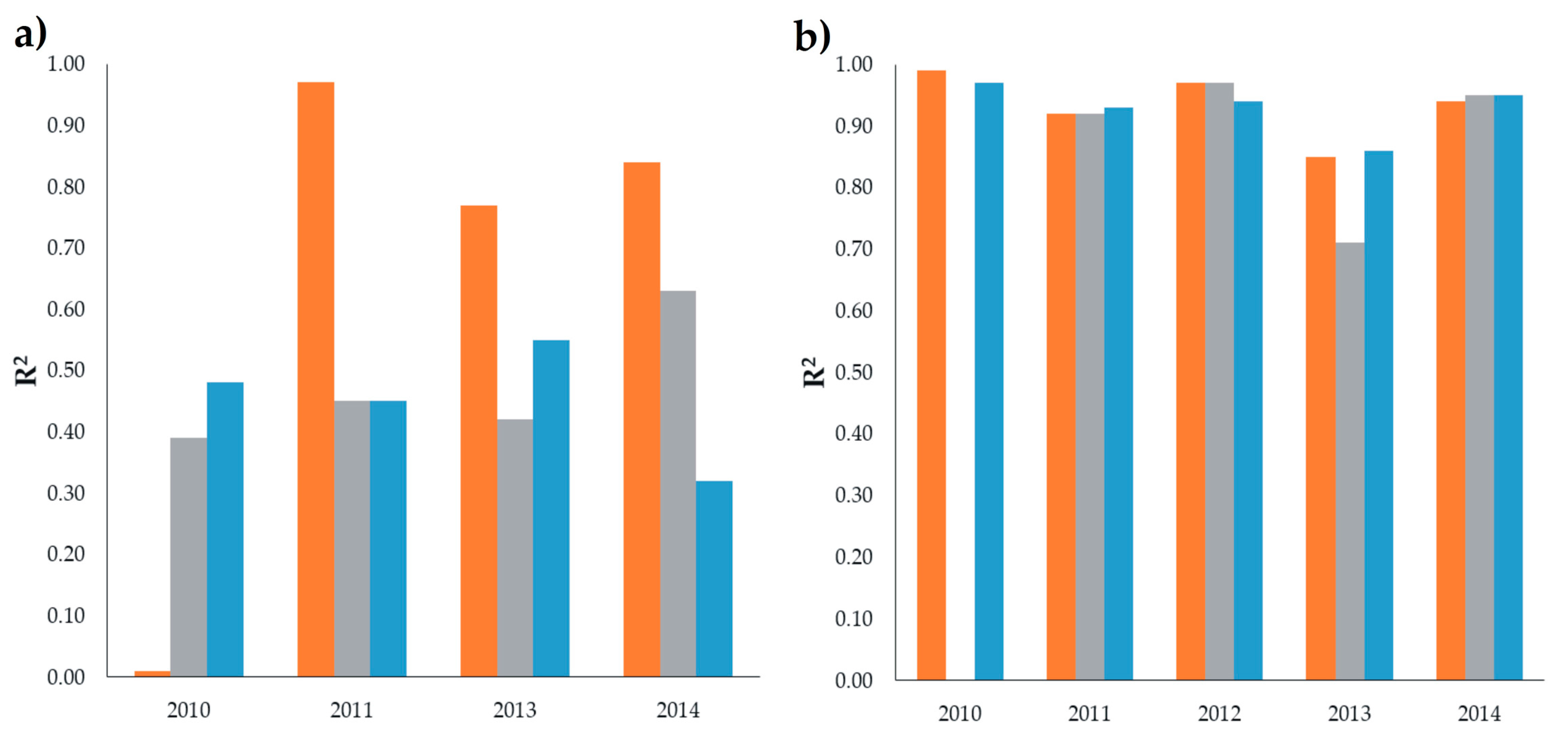
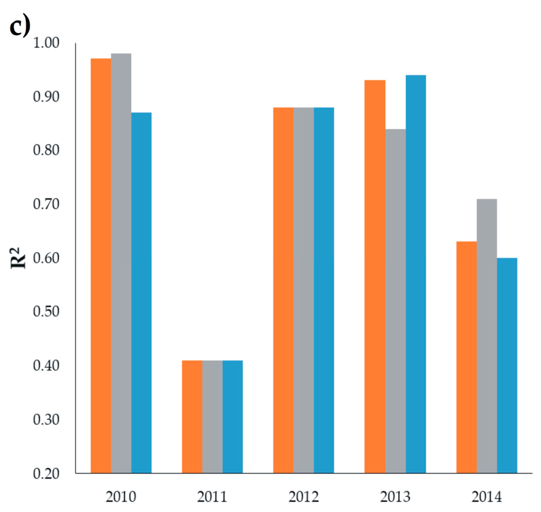
 ), DOS1 (
  ) and FLAASH (
  ). NIR: near infra-red; SWIR: shortwave infra-red.
), DOS1 ( ) and FLAASH ( ). NIR: near infra-red; SWIR: shortwave infra-red.
). NIR: near infra-red; SWIR: shortwave infra-red.
), DOS1 ( ) and FLAASH ( ). NIR: near infra-red; SWIR: shortwave infra-red. ), DOS1 ( ), and FLAASH ( ).
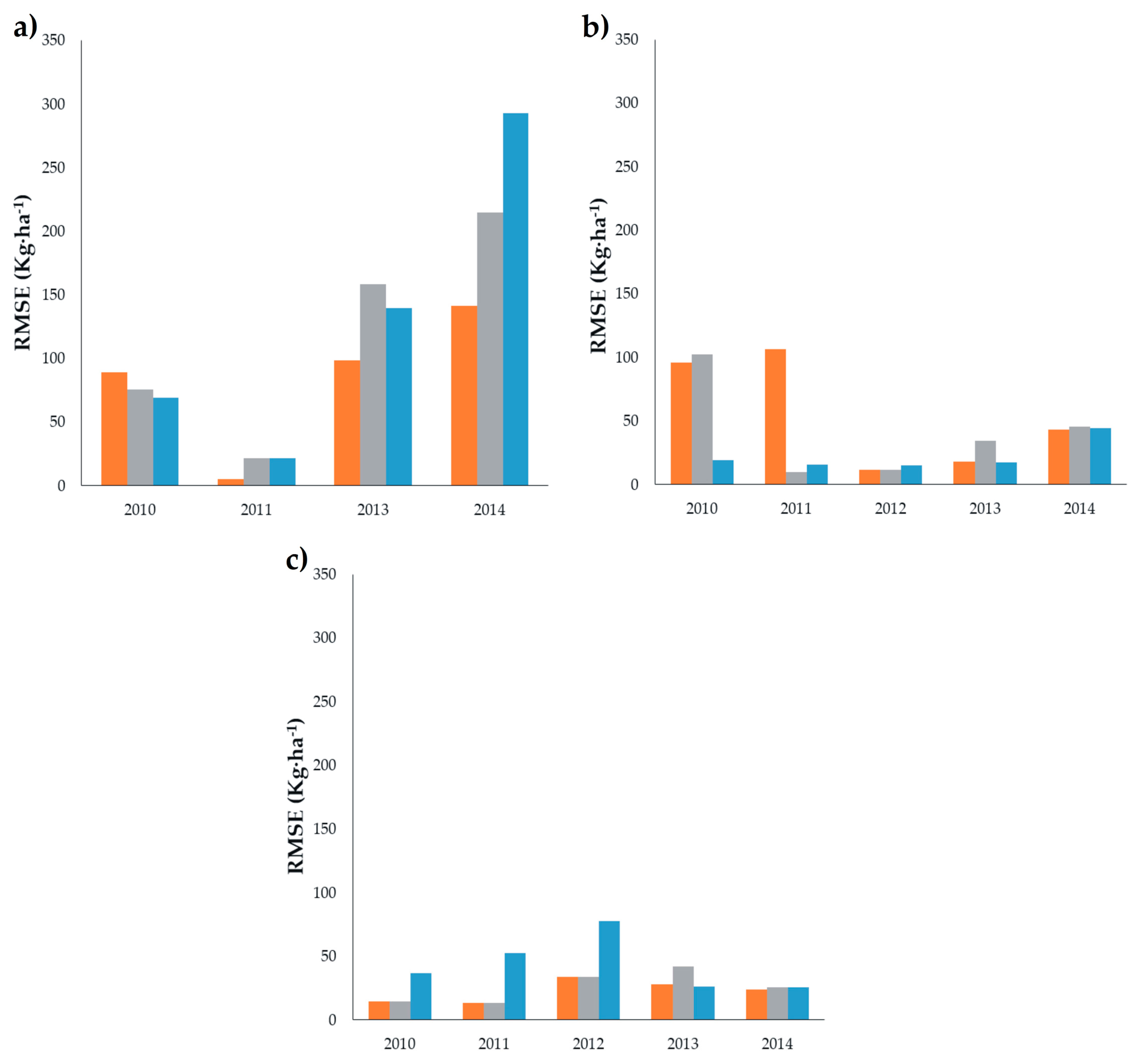
), DOS1 ( ), and FLAASH ( ).
), DOS1 ( ), and FLAASH ( ). ), DOS1 ( ), and FLAASH ( ).
), DOS1 ( ), and FLAASH ( ).
), DOS1 ( ), and FLAASH ( ). ), DOS1 ( ) and FLAASH ( ) through single band.
), DOS1 ( ) and FLAASH ( ) through single band.
), DOS1 ( ) and FLAASH ( ) through single band. ), DOS1 ( ) and FLAASH ( ) through single band.
), DOS1 ( ) and FLAASH ( ) through single band.
), DOS1 ( ) and FLAASH ( ) through single band. ), DOS1 ( ), and FLAASH ( ) through PC.
), DOS1 ( ), and FLAASH ( ) through PC.
), DOS1 ( ), and FLAASH ( ) through PC.
 ), DOS1 ( ), and FLAASH ( ) through PC.
), DOS1 ( ), and FLAASH ( ) through PC.
), DOS1 ( ), and FLAASH ( ) through PC.

| PMS | Scene ID | Date of Image | Sensor | Path/Row |
|---|---|---|---|---|
| Eden | LT50310412010279EDC00 | 6 October 2010 | TM | 31/41 |
| LT50310412011298EDC00 | 25 October 2011 | |||
| LC80310412013319LGN00 | 15 November 2013 | OLI | ||
| LC80310412014274LGN00 | 1 October 2014 | |||
| El Sitio | LT50320412010302EDC00 | 29 October 2010 | TM | 32/41 |
| LT50320412011305EDC00 | 1 November 20111 | |||
| LE70320412012028EDC00 | 28 October 2012 | |||
| LC80320412013278LGN00 | 5 October 2013 | OLI | ||
| LC80320412014281LGN00 | 8 October 2014 | |||
| Teseachi | LT50330402010309EDC00 | 5 November 2010 | TM | 33/40 |
| LT50330402011296EDC00 | 23 October 2011 | |||
| LE70330402012339EDC00 | 4 December 2012 | |||
| LC80330402013285LGN00 | 12 October 2013 | OLI | ||
| LC80330402014288LGN00 | 15 October 2014 |
| No | Site | CA | Year | Band (Spectrum Region) | R2 | RMSE (kg·ha−1) |
|---|---|---|---|---|---|---|
| 1 | Eden | ATCOR2 | 2010 | 1 (Blue) | 0.35 | 72.01 |
| 2 | 2011 | 1 (Blue) | 0.22 | 23.92 | ||
| 3 | 2012 | n/d | n/d | n/d | ||
| 4 | 2013 | 2 (Blue) | 0.38 | 153.31 | ||
| 5 | 2014 | 6 (SWIR1) | 0.05 | 321.27 | ||
| 6 | DOS1 | 2010 | 2 (Green) | 0.02 | 88.36 | |
| 7 | 2011 | 1 (Blue) | 0.12 | 25.42 | ||
| 8 | 2012 | n/d | n/d | n/d | ||
| 9 | 2013 | 5 (NIR) | 0.19 | 174.70 | ||
| 10 | 2014 | 5 (NIR) | 0.48 * | 237.99 | ||
| 11 | FLAASH | 2010 | 1 (Blue) | 0.19 | 80.11 | |
| 12 | 2011 | 1 (Blue) | 0.20 | 24.22 | ||
| 13 | 2012 | n/d | n/d | n/d | ||
| 14 | 2013 | 2 (Blue) | 0.31 | 161.73 | ||
| 15 | 2014 | 7 (SWIR2) | 0.04 | 323.04 | ||
| 1 | El Sitio | ATCOR2 | 2010 | 1 (Blue) | 0.08 | 98.32 |
| 2 | 2011 | 1 (Blue) | 0.09 | 54.14 | ||
| 3 | 2012 | 2 (Green) | 0.07 | 54.14 | ||
| 4 | 2013 | 2 (Blue) | 0.40 | 34.43 | ||
| 5 | 2014 | 5 (NIR) | 0.81 * | 84.16 | ||
| 6 | DOS1 | 2010 | 5 (SWIR1) | 0.10 | 97.21 | |
| 7 | 2011 | 7 (SWIR2) | 0.26 | 302.29 | ||
| 8 | 2012 | 2 (Green) | 0.07 | 59.06 | ||
| 9 | 2013 | 5 (NIR) | 0.46 * | 32.54 | ||
| 10 | 2014 | 5 (NIR) | 0.81 * | 84.16 | ||
| 11 | FLAASH | 2010 | 1 (Blue) | 0.02 | 101.54 | |
| 12 | 2011 | 1 (Blue) | 0.27 | 29.10 | ||
| 13 | 2012 | 2 (Green) | 0.08 | 58.94 | ||
| 14 | 2013 | 5 (NIR) | 0.67 * | 26.24 | ||
| 15 | 2014 | 5 (NIR) | 0.79 * | 86.66 | ||
| 1 | Teseachi | ATCOR2 | 2010 | 5 (SWIR1) | 0.26 | 82.58 |
| 2 | 2011 | 3 (Red) | 0.40 | 52.92 | ||
| 3 | 2012 | 5 (SWIR1) | 0.42 | 70.76 | ||
| 4 | 2013 | 7 (SWIR2) | 0.76 * | 48.79 | ||
| 5 | 2014 | 5 (NIR) | 0.57 * | 40.90 | ||
| 6 | DOS1 | 2010 | 7 (SWIR2) | 0.44 * | 71.42 | |
| 7 | 2011 | 3 (Red) | 0.40 | 52.93 | ||
| 8 | 2012 | 7 (SWIR2) | 0.72 * | 48.65 | ||
| 9 | 2013 | 7 (SWIR2) | 0.76 * | 48.79 | ||
| 10 | 2014 | 5 (NIR) | 0.42 * | 40.90 | ||
| 11 | FLAASH | 2010 | 7 (SWIR2) | 0.44 * | 71.44 | |
| 12 | 2011 | 3 (Red) | 0.40 | 53.00 | ||
| 13 | 2012 | 7 (SWIR2) | 0.72 * | 60.76 | ||
| 14 | 2013 | 7 (SWIR2) | 0.76 * | 77.97 | ||
| 15 | 2014 | 6 (SWIR1) | 0.57 * | 40.61 |
| No | Site | Correction Method | Year | PC1 | PC2 | R2 | RMSE (kg·ha−1) |
|---|---|---|---|---|---|---|---|
| Bands | Bands | ||||||
| 1 | Eden | ATCOR2 | 2010 | 1 2 3 4 | 5 7 | 0.48 | 69.08 |
| 2 | 2011 | 1 2 3 | 4 5 7 | 0.45 | 21.54 | ||
| 3 | 2012 | n/d | n/d | n/d | n/d | ||
| 4 | 2013 | 2 3 4 | 6 7 | 0.55 | 139.53 | ||
| 5 | 2014 | 2 3 4 | 6 7 | 0.32 | 292.99 | ||
| 6 | DOS1 | 2010 | 1 2 3 4 5 7 | 0.01 | 88.78 | ||
| 7 | 2011 | 1 2 | 3 4 5 7 | 0.97 * | 4.97 | ||
| 8 | 2012 | n/d | n/d | n/d | n/d | ||
| 9 | 2013 | 2 3 4 6 7 | 5 | 0.77 * | 98.49 | ||
| 10 | 2014 | 2 3 4 6 7 | 5 | 0.84 * | 141.18 | ||
| 11 | FLAASH | 2010 | 1 4 7 | 3 | 0.39 | 75.30 | |
| 12 | 2011 | 4 7 | 1 2 3 | 0.45 | 21.56 | ||
| 13 | 2012 | n/d | n/d | n/d | n/d | ||
| 14 | 2013 | 3 4 5 6 7 | 2 | 0.42 | 158.38 | ||
| 15 | 2014 | 2 3 4 | 5 6 7 | 0.63 * | 214.41 | ||
| 16 | El Sitio | ATCOR2 | 2010 | 1 2 3 | 4 7 | 0.97 * | 19.10 |
| 17 | 2011 | 1 2 3 | 4 5 | 0.93 * | 15.82 | ||
| 18 | 2012 | 2 3 4 5 7 | 1 | 0.94 * | 15.20 | ||
| 19 | 2013 | 3 4 6 7 | 2 5 | 0.86 * | 17.36 | ||
| 20 | 2014 | 2 3 4 6 7 | 5 | 0.95 * | 44.52 | ||
| 21 | DOS1 | 2010 | 2 3 4 5 7 | 0.99 * | 95.61 | ||
| 22 | 2011 | 1 2 3 4 5 7 | 7 | 0.92 * | 106.37 | ||
| 23 | 2012 | 2 3 4 5 7 | 1 | 0.97 ** | 11.46 | ||
| 24 | 2013 | 2 3 4 6 7 | 5 | 0.85 * | 18.09 | ||
| 25 | 2014 | 2 3 4 6 7 | 5 | 0.94 * | 43.24 | ||
| 26 | FLAASH | 2010 | 1 2 3 4 5 7 | 0.00 | 102.50 | ||
| 27 | 2011 | 2 3 4 | 1 5 7 | 0.92 * | 9.90 | ||
| 28 | 2012 | 1 2 | 3 4 5 7 | 0.97 ** | 11.39 | ||
| 29 | 2013 | 3 4 6 7 | 2 5 | 0.71 | 34.29 | ||
| 30 | 2014 | 2 3 4 6 7 | 5 | 0.95 ** | 45.61 | ||
| 31 | Teseachi | ATCOR2 | 2010 | 1 2 3 4 | 5 7 | 0.87 * | 36.92 |
| 32 | 2011 | 1 2 3 | 0.41 | 52.32 | |||
| 33 | 2012 | 1 2 3 4 | 5 7 | 0.88 * | 77.96 | ||
| 34 | 2013 | 3 4 5 | 2 6 7 | 0.94 * | 25.92 | ||
| 35 | 2014 | 2 3 4 5 6 7 | 0.60 * | 25.35 | |||
| 36 | DOS1 | 2010 | 1 2 3 4 | 5 7 | 0.97 ** | 14.69 | |
| 37 | 2011 | 1 2 3 | 0.41 | 13.09 | |||
| 38 | 2012 | 1 2 3 4 | 5 7 | 0.88 * | 33.62 | ||
| 39 | 2013 | 2 3 6 7 | 4 5 | 0.93 * | 28.03 | ||
| 40 | 2014 | 2 3 4 5 6 7 | 0.63 * | 23.53 | |||
| 41 | FLAASH | 2010 | 1 2 3 4 | 5 7 | 0.98 ** | 14.63 | |
| 42 | 2011 | 1 2 3 | 0.41 | 13.24 | |||
| 43 | 2012 | 1 2 3 4 | 5 7 | 0.88 * | 33.49 | ||
| 44 | 2013 | 2 3 6 7 | 4 5 | 0.84 * | 42.16 | ||
| 45 | 2014 | 2 6 7 | 3 4 5 | 0.71 | 25.50 |
© 2018 by the authors. Licensee MDPI, Basel, Switzerland. This article is an open access article distributed under the terms and conditions of the Creative Commons Attribution (CC BY) license (http://creativecommons.org/licenses/by/4.0/).
Share and Cite
Prieto-Amparan, J.A.; Villarreal-Guerrero, F.; Martinez-Salvador, M.; Manjarrez-Domínguez, C.; Santellano-Estrada, E.; Pinedo-Alvarez, A. Atmospheric and Radiometric Correction Algorithms for the Multitemporal Assessment of Grasslands Productivity. Remote Sens. 2018, 10, 219. https://doi.org/10.3390/rs10020219
Prieto-Amparan JA, Villarreal-Guerrero F, Martinez-Salvador M, Manjarrez-Domínguez C, Santellano-Estrada E, Pinedo-Alvarez A. Atmospheric and Radiometric Correction Algorithms for the Multitemporal Assessment of Grasslands Productivity. Remote Sensing. 2018; 10(2):219. https://doi.org/10.3390/rs10020219
Chicago/Turabian StylePrieto-Amparan, Jesús A., Federico Villarreal-Guerrero, Martin Martinez-Salvador, Carlos Manjarrez-Domínguez, Eduardo Santellano-Estrada, and Alfredo Pinedo-Alvarez. 2018. "Atmospheric and Radiometric Correction Algorithms for the Multitemporal Assessment of Grasslands Productivity" Remote Sensing 10, no. 2: 219. https://doi.org/10.3390/rs10020219
APA StylePrieto-Amparan, J. A., Villarreal-Guerrero, F., Martinez-Salvador, M., Manjarrez-Domínguez, C., Santellano-Estrada, E., & Pinedo-Alvarez, A. (2018). Atmospheric and Radiometric Correction Algorithms for the Multitemporal Assessment of Grasslands Productivity. Remote Sensing, 10(2), 219. https://doi.org/10.3390/rs10020219