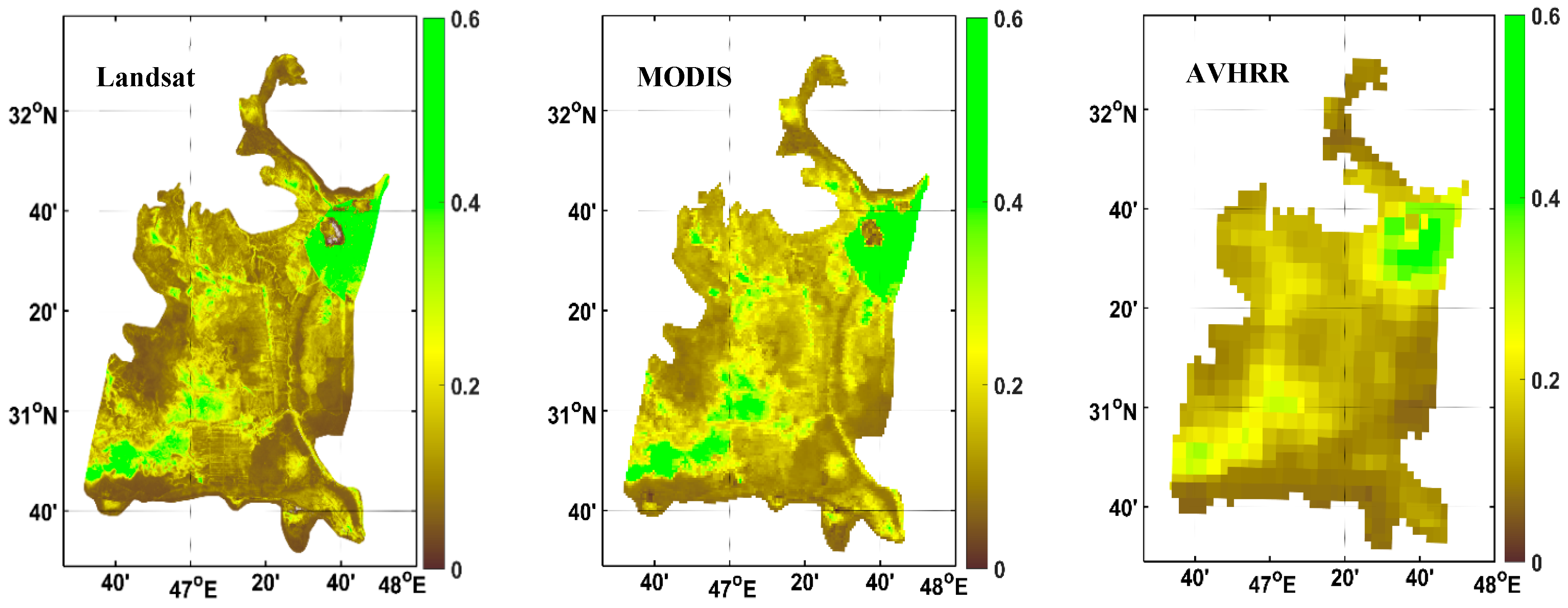
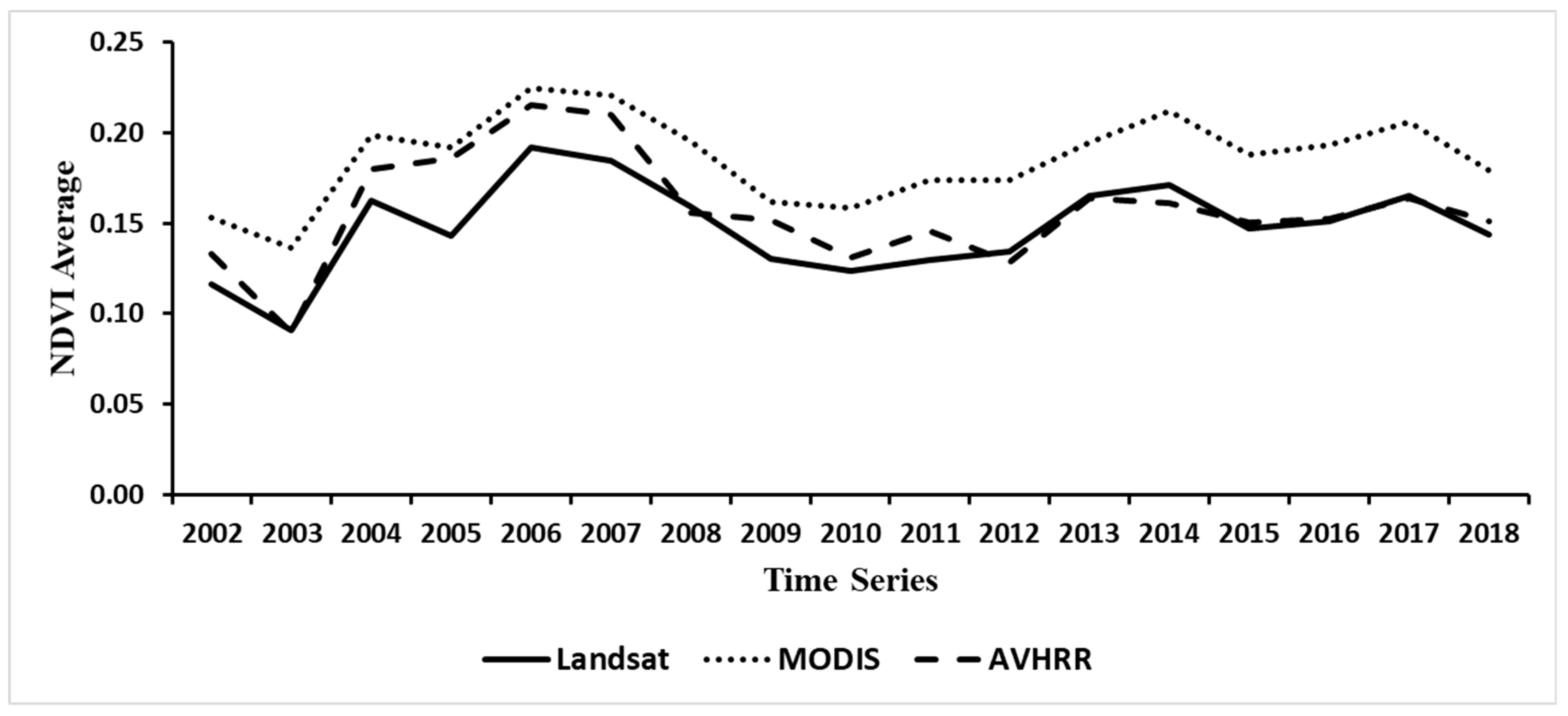
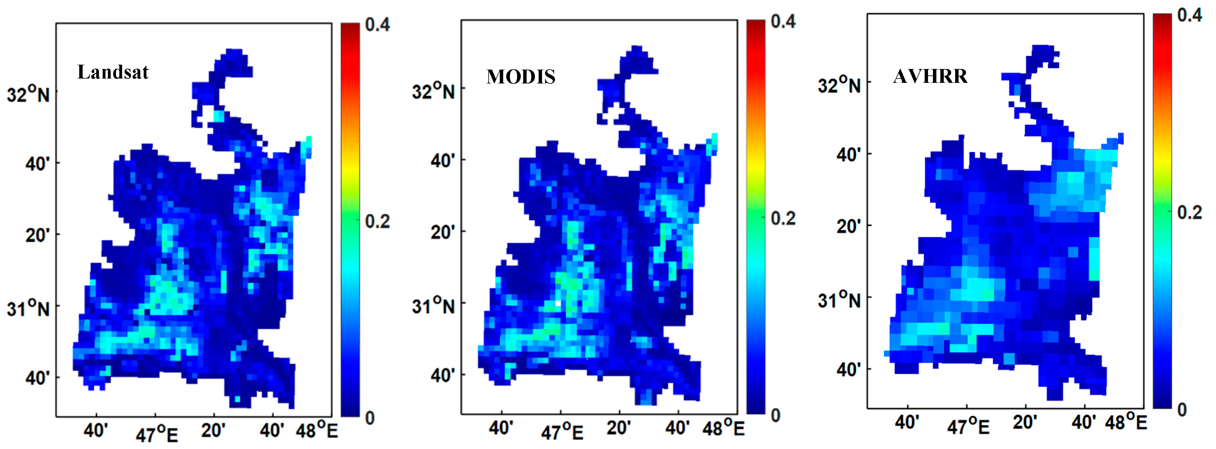
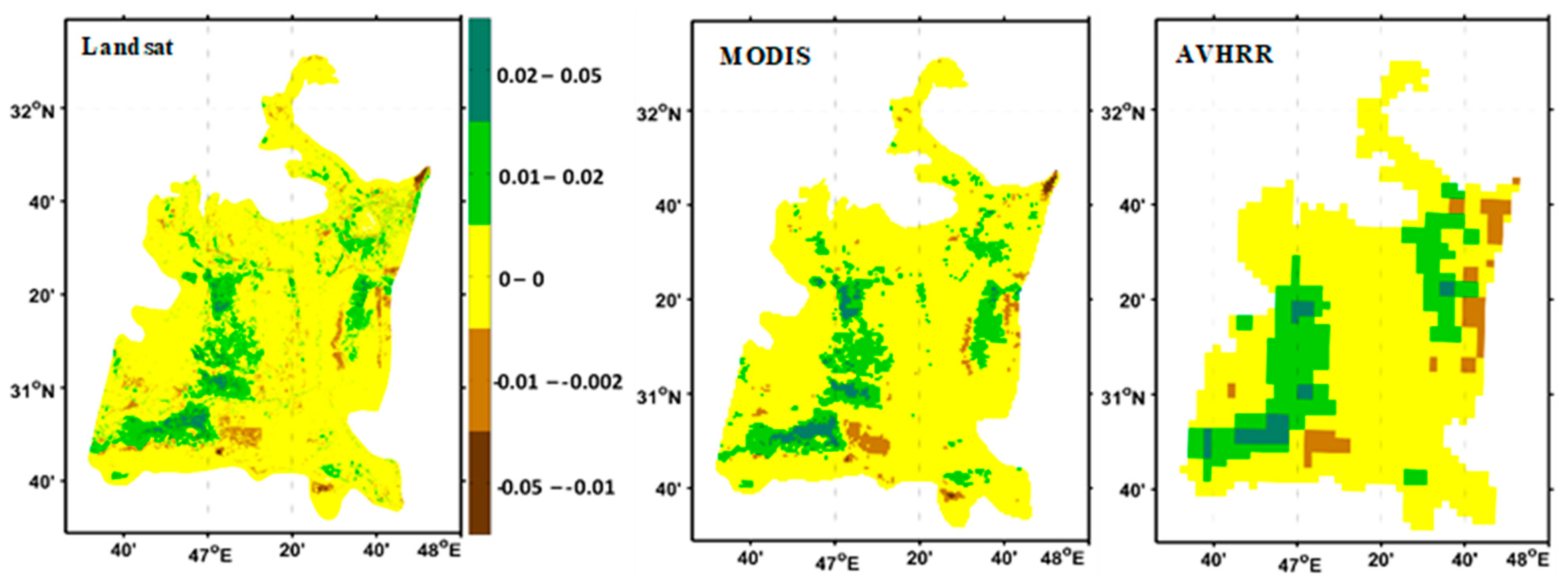
Comparison of Normalized Difference Vegetation Index Derived from Landsat, MODIS, and AVHRR for the Mesopotamian Marshes Between 2002 and 2018
Abstract
:1. Introduction
2. Datasets and Methods
2.1. Study Area
2.2. Data
2.2.1. AVHRR LTDR V5 Daily NDVI Product
2.2.2. MODIS Data
2.2.3. Landsat
2.2.4. Additional Data
2.3. Methodology
3. Result
3.1. Time Series Analysis
3.2. Comparison of Linear NDVI Trend Components
4. Discussion
5. Conclusion
Author Contributions
Funding
Acknowledgments
Conflicts of Interest
References
- Richardson, C.J.; Hussain, N.A. Restoring the garden of Eden: An ecological assessment of the marshes of Iraq. AIBS Bull. 2006, 56, 477–489. [Google Scholar] [CrossRef]
- Albarakat, R.; Lakshmi, V.; Tucker, C. Using Satellite Remote Sensing to Study the Impact of Climate and Anthropogenic Changes in the Mesopotamian Marshlands, Iraq. Remote Sens. 2018, 10, 1524. [Google Scholar] [CrossRef]
- CIMI (Canada-Iraq Marshlands Initiative). Managing for Change: The Present and Future State of the Marshes of Southern Iraq; University of Victoria: Victoria, BC, Canada; Canadian International Development Agency: Gatineau, QC, Canada, 2010.
- Douabul, A.A.Z.; Al-Saad, H.T.; Abdullah, D.S.; Salman, N.A. Designated protected Marsh within Mesopotamia: Water quality. Am. J. Water Resour. 2013, 1, 39–44. [Google Scholar]
- Partow, H. The Mesopotamian Marshlands: Demise of an Ecosystem; Division of Early Warning and Assessment, United Nations Environment Programme; UNEP Publication: Nairobi, Kenya, 2001. [Google Scholar]
- Maltby, E. An Environmental and Ecological Study of the Marshlands of Mesopotamia Wetland Ecosystem; AMAR Appeal Trust; University of Exeter: London, UK, 1994. [Google Scholar]
- Vinez, M.; Leonard, S. The Iraq Marshlands: The Loss of the Garden of Eden and Its People; PLSI No. 3443; Illinois State University: Normal, IL, USA, 2010. [Google Scholar]
- Stellmes, M.; Udelhoven, T.; Röder, A.; Sonnenschein, R.; Hill, J. Dryland observation at local and regional scale—Comparison of Landsat TM/ETM+ and NOAA AVHRR time series. Remote Sens. Environ. 2010, 114, 2111–2125. [Google Scholar] [CrossRef]
- Turner, B.L.; Lambin, E.F.; Reenberg, A. The emergence of land change science for global environmental change and sustainability. Proc. Natl. Acad. Sci. USA 2007, 104, 20666–20671. [Google Scholar] [CrossRef] [Green Version]
- Tucker, C.J. Red and photographic infrared linear combinations for monitoring vegetation. Remote Sens. Environ. 1979, 8, 127–150. [Google Scholar] [CrossRef] [Green Version]
- Escuin, S.; Navarro, R.; Fernandez, P. Fire severity assessment by using NBR (Normalized Burn Ratio) and NDVI (Normalized Difference Vegetation Index) derived from LANDSAT TM/ETM images. Int. J. Remote Sens. 2008, 29, 1053–1073. [Google Scholar] [CrossRef]
- Brown, M.E.; Pinzón, J.E.; Didan, K.; Morisette, J.T.; Tucker, C.J. Evaluation of the consistency of long-term NDVI time series derived from AVHRR, SPOT-vegetation, SeaWiFS, MODIS, and Landsat ETM+ sensors. IEEE Trans. Geosci. Remote Sens. 2006, 44, 1787–1793. [Google Scholar] [CrossRef]
- Gallo, K.; Ji, L.; Reed, B.; Eidenshink, J.; Dwyer, J. Multi-platform comparisons of MODIS and AVHRR normalized difference vegetation index data. Remote Sens. Environ. 2005, 99, 221–231. [Google Scholar] [CrossRef] [Green Version]
- Tong, A.; He, Y. Comparative analysis of SPOT, Landsat, MODIS, and AVHRR normalized difference vegetation index data on the estimation of leaf area index in a mixed grassland ecosystem. J. Appl. Remote Sens. 2013, 7, 073599. [Google Scholar] [CrossRef]
- Goetz, S.J. Multi-sensor analysis of NDVI, surface temperature and biophysical variables at a mixed grassland site. Int. J. Remote Sens. 1997, 18, 71–94. [Google Scholar] [CrossRef]
- Gianelle, D.; Vescovo, L.; Mason, F. Estimation of grassland biophysical parameters using hyperspectral reflectance for fire risk map prediction. Int. J. Wildland Fire 2009, 18, 815–824. [Google Scholar] [CrossRef]
- Guo, X.; Zhang, H.; Wu, Z.; Zhao, J.; Zhang, Z. Comparison and evaluation of annual NDVI time series in China derived from the NOAA AVHRR LTDR and Terra MODIS mod13c1 products. Sensors 2017, 17, 1298. [Google Scholar]
- Peng, J.; Liu, Z.; Liu, Y.; Wu, J.; Han, Y. Trend analysis of vegetation dynamics in Qinghai—Tibet Plateau using Hurst Exponent. Ecol. Indic. 2012, 14, 28–39. [Google Scholar] [CrossRef]
- Zhao, J.; Wang, Y.; Hashimoto, H.; Melton, F.S.; Hiatt, S.H.; Zhang, H.; Nemani, R.R. The variation of land surface phenology from 1982 to 2006 along the Appalachian Trail. IEEE Trans. Geosci. Remote Sens. 2013, 51, 2087–2095. [Google Scholar] [CrossRef]
- Piao, S.; Fang, J.; Zhou, L.; Guo, Q.; Henderson, M.; Ji, W.; Li, Y.; Tao, S. Interannual variations of monthly and seasonal normalized difference vegetation index (NDVI) in China from 1982 to 1999. J. Geophys. Res. Atmos. 2003, 108, 4401. [Google Scholar] [CrossRef]
- Mao, D.; Wang, Z.; Luo, L.; Ren, C. Integrating AVHRR and MODIS data to monitor NDVI changes and their relationships with climatic parameters in Northeast China. Int. J. Appl. Earth Obs. Geoinform. 2012, 18, 528–536. [Google Scholar] [CrossRef]
- Chirici, G.; Chiesi, M.; Corona, P.; Puletti, N.; Mura, M.; Maselli, F. Prediction of forest NPP in Italy by the combination of ground and remote sensing data. Eur. J. For. Res. 2015, 134, 453–467. [Google Scholar] [CrossRef] [Green Version]
- Patil, V.; Singh, A.; Naik, N.; Unnikrishnan, S. Estimation of mangrove carbon stocks by applying remote sensing and GIS techniques. Wetlands 2015, 35, 695–707. [Google Scholar] [CrossRef]
- Ruimy, A.; Saugier, B.; Dedier, G. Methodology for the estimation of terrestrial net primary production from remotely sensed data. J. Geophys. Res. 1994, 99, 5263–5283. [Google Scholar] [CrossRef]
- Prince, S.D.; Goward, S.N. Global primary production: A remote sensing approach. J. Biogeogr. 1995, 22, 815–835. [Google Scholar] [CrossRef]
- Pedelty, J.; Devadiga, S.; Masuoka, E.; Brown, M.; Pinzon, J.; Tucker, C.; Roy, D.P.; Ju, J.; Vermote, E.F.; Prince, S.D.; et al. Generating a long-term land data record from the AVHRR and MODIS Instruments. In Proceedings of the IEEE International Geoscience and Remote Sensing Symposium, Barcelona, Spain, 23–28 July 2007; pp. 1021–1025. [Google Scholar]
- McCloy, K.R.; Los, S.; Lucht, W.; Højsgaard, S. A comparative analysis of three longterm NDVI data sets derived from AVHRR satellite data. EARSeL eProc. 2005, 4, 52–69. [Google Scholar]
- Anyamba, A.; Tucker, C.J. Analysis of Sahelian vegetation dynamics using NOAA AVHRR NDVI data from 1981–2003. J. Arid Environ. 2005, 63, 596–614. [Google Scholar] [CrossRef]
- Jeyaseelan, A.T.; Roy, P.S.; Young, S.S. Persistent changes in NDVI between 1982 and 2003 over India using AVHRR GIMMS (Global Inventory Modeling and Mapping Studies) data. Int. J. Remote Sens. 2007, 28, 4927–4946. [Google Scholar] [CrossRef]
- Helldén, U.; Tottrup, C. Regional desertification: A global synthesis. Global Planet Chang. 2008, 64, 169–176. [Google Scholar] [CrossRef]
- Xiao, J.; Moody, A. Geographical distribution of global greening trends and their climatic correlates: 1982–1998. Int. J. Remote Sens. 2005, 26, 2371–2390. [Google Scholar] [CrossRef]
- Hickler, T.; Eklundh, L.; Seaquist, J.; Smith, B.; Ardö, J.; Olsson, L.; Sykes, M.T.; Sjostrom, M. Precipitation controls Sahel greening trend. Geophys. Res. Lett. 2005, 32, L21415. [Google Scholar] [CrossRef]
- Herrmann, S.M.; Anyamba, A.; Tucker, C.J. Recent trends in vegetation dynamics in the African Sahel and their relationship to climate. Global Environ. Chang. 2005, 15, 394–404. [Google Scholar] [CrossRef]
- Fensholt, R.; Rasmussen, K.; Nielsen, T.T.; Mbow, C. Evaluation of earth observation based long term vegetation trends—Intercomparing NDVI time series trend analysis consistency of Sahel from AVHRR GIMMS, Terra MODIS, and SPOT VGT data. Remote Sens. Environ. 2009, 113, 1886–1898. [Google Scholar] [CrossRef]
- Viedma, O.; Moreno, J.M.; Rieiro, I. Interactions between land use/land cover change, forest fires and landscape structure in Sierra de Gredos (Central Spain). Environ. Conserv. 2006, 33, 212–222. [Google Scholar] [CrossRef]
- Röder, A.; Udelhoven, T.; Hill, J.; del Barrio, G.; Tsiourlis, G. Trend analysis of Landsat-TM and ETM+ imagery to monitor grazing impact in a rangeland ecosystem in Northern Greece. Remote Sens. Environ. 2008, 112, 2863–2875. [Google Scholar] [CrossRef]
- Röder, A.; Duguy, B.; Alloza, J.A.; Vallejo, R.; Hill, J. Using long time series of Landsat data to monitor fire events and post-fire dynamics and identify driving factors. Remote Sens. Environ. 2008, 112, 259–273. [Google Scholar] [CrossRef]
- Kennedy, R.E.; Cohen, W.B.; Schroeder, T.A. Trajectory-based change detection for automated characterization of forest disturbance dynamics. Remote Sens. Environ. 2007, 110, 370–386. [Google Scholar] [CrossRef]
- Hostert, P.; Röder, A.; Hill, J. Coupling spectral unmixing and trend analysis for monitoring of long-term vegetation dynamics in Mediterranean rangelands. Remote Sens. Environ. 2003, 87, 183–197. [Google Scholar] [CrossRef]
- Fensholt, R. Earth observation of vegetation status in the Sahelian and Sudanian West Africa: Comparison of Terra MODIS and NOAA AVHRR satellite data. Int. J. Remote Sens. 2004, 25, 1641–1659. [Google Scholar] [CrossRef]
- Huete, A.R.; Didan, K.; Miura, T.; Rodriguez, E.P.; Gao, X.; Ferreira, L.G. Overview of the radiometric and biophysical performance of the MODIS vegetation indices. Remote Sens. Environ. 2002, 83, 195–213. [Google Scholar] [CrossRef]
- Kawamura, K.; Akiyama, T.; Yokota, H.; Tsutsumi, M.; Yasuda, T.; Watanabe, O.; Wang, S. Comparing MODIS vegetation indices with AVHRR NDVI for monitoring the forage quantity and quality in Inner Mongolia grassland, China. Grassl. Sci. 2005, 51, 33–40. [Google Scholar] [CrossRef]
- Tarnavsky, E.; Garrigues, S.; Brown, M.E. Multiscale geostatistical analysis of AVHRR, SPOT-VGT, and MODIS global NDVI products. Remote Sens. Environ. 2008, 112, 535–549. [Google Scholar] [CrossRef]
- Tucker, C.J.; Pinzon, J.E.; Brown, M.E.; Slayback, D.A.; Pak, E.W.; Mahoney, R.; Vermote, E.F.; Saleous, N.E. An extended AVHRR 8-km NDVI dataset compatible with MODIS and SPOT vegetation NDVI data. Int. J. Remote Sens. 2005, 2, 4485–4498. [Google Scholar] [CrossRef]
- Venturini, V.; Bisht, G.; Islam, S.; Jiang, L. Comparison of evaporative fractions estimated from AVHRR and MODIS sensors over South Florida. Remote Sens. Environ. 2004, 93, 77–86. [Google Scholar] [CrossRef]
- Maxwell, G. People of the Reeds; ASIN: B0007DMCTC; Harper: New York, NY, USA, 1957; 223p. [Google Scholar]
- Young, G. Return to the Marshes: Life with the Marsh Arabs of Iraq; Collins: London, UK, 1977; 224p, ISBN 9780571280971. [Google Scholar]
- Lubinski, B.J.; Jackson, J.R.; Eggleton, M.A. Relationships between floodplain lake fish communities and environmental variables in a large river-floodplain ecosystem. Trans. Am. Fish Soc. 2008, 137, 895–908. [Google Scholar] [CrossRef]
- Peltier, L.C. The geographic cycle in periglacial regions as it is related to climatic geomorphology. Ann. Assoc. Am. Geogr. 1950, 40, 214–236. [Google Scholar] [CrossRef]
- Fookes, P.G.; Dearman, W.R.; Franklin, J.A. Some engineering aspects of rock weathering with field examples from Dartmoor and elsewhere. Q. J. Eng. Geol. Hydrogeol. 1971, 4, 139–185. [Google Scholar] [CrossRef]
- Richardson, C.J. The Status of Mesopotamian Marsh Restoration in Iraq: A Case Study of Transboundary Water Issues and Internal Water Allocation Problems; Towards New Solutions in Managing Environmental Crisis; University of Helsinki: Helsinki, Finland, 2010. [Google Scholar]
- Rogan, J.; Franklin, J.; Roberts, D.A. A comparison of methods for monitoring multitemporal vegetation change using thematic mapper imagery. Remote Sens. Environ. 2002, 80, 143–156. [Google Scholar] [CrossRef]
- Finlayson, C.; Davidson, N.; Spiers, A.; Stevenson, N. Global wetland inventory—Current status and future priorities. Mar. Freshw. Res. 1999, 50, 717–727. [Google Scholar] [CrossRef]
- Moreno Ruiz, J.A.; Riaño, D.; Arbelo, M.; French, N.H.F.; Ustin, S.L.; Whiting, M.L. Burned area mapping time series in Canada (1984–1999) from NOAA-AVHRR LTDR: A comparison with other remote sensing products and fire perimeters. Remote Sens. Environ. 2012, 117, 407–414. [Google Scholar] [CrossRef]
- Moreno-Ruiz, J.A.; Riano, D.; Garcia-Lazaro, J.R.; Ustin, S.L. Intercomparison of AVHRR PAL and LTDR version 2 long-term data sets for Africa from 1982 to 2000 and its impact on mapping burned area. IEEE Geosci. Remote Sens. Lett. 2009, 6, 738–742. [Google Scholar] [CrossRef]
- Ruiz, J.A.M.; Lázaro, J.R.G.; Cano, I.D.Á.; Leal, P.H. Burned area mapping in the North American boreal forest using Terra-MODIS LTDR (2001–2011): A comparison with the MCD45A1, MCD64A1, and BA GEOLAND-2 products. Remote Sens. 2014, 6, 815–840. [Google Scholar] [CrossRef]
- Ghulam, A.; Kasimu, A.; Kusky, T. Normalization of modified perpendicular drought index using LTDR and GIMMS dataset for drought assessment in the United States. In Proceedings of the IEEE International Geoscience and Remote Sensing Symposium, Boston, MA, USA, 7–11 July 2008; pp. III-856–III-859. [Google Scholar]
- Vermote, E. Climate Algorithm Theoretical Basis Document (C-ATBD): AVHRR Land Bundle-Surface Reflectance and Normalized Difference Vegetation Index. 2013.f3. Available online: https://www.ncdc.noaa. gov (accessed on 20 November 2018).
- Holben, B.N. Characteristics of maximum-value composite images from temporal avhrr data. Int. J. Remote Sens. 1986, 7, 1417–1434. [Google Scholar] [CrossRef]
- Huete, A.; Didan, K.; van Leeuwen, W.; Miura, T.; Glenn, E. MODIS vegetation indices. In Land Remote Sensing and Global Environmental Change; Springer: New York, NY, USA, 2010; pp. 579–602. [Google Scholar]
- Vermote, E.F.; El Saleous, N.Z.; Justice, C.O. Atmospheric correction of MODIS data in the visible to middle infrared: First results. Remote Sens. Environ. 2002, 83, 97–111. [Google Scholar] [CrossRef]
- NASA ESPA. Landsat 7 Etm+ Level 2 Landsat 4-7 Surface Reflectance (Ledaps) Product GUIDE USGS Earth Resources Observation and Science (EROS) Center, Sioux Falls, South Dakota. 2018. Available online: https://lpdaac.usgs.gov (accessed on 8 September 2018).
- Altinbilek, D. Development and management of the Euphrates–Tigris basin. Int. J. Water Resour. Dev. 2004, 20, 15–33. [Google Scholar] [CrossRef]
- Bédard, F.; Crump, S.; Gaudreau, J. A comparison between Terra MODIS and NOAA AVHRR NDVI satellite image composites for the monitoring of natural grassland conditions in Alberta, Canada. Can. J. Remote Sen. 2006, 32, 44–50. [Google Scholar] [CrossRef]
- Tsuchiya, K.; Kaneko, M.; Sung, S.J. Comparison of image data acquired with AVHRR, MODIS, ETM+, and ASTER over Hokkaido, Japan. Adv. Space Res. 2003, 32, 2211–2216. [Google Scholar]


| Sensor/Model | Variable | Spatial Resolution | Temporal Resolution | Coverage |
|---|---|---|---|---|
| AVHRR 1 | NDVI 2 | 0.05° (~5 km) | Daily | 1981–Present |
| MODIS 3 | NDVI | 1 km | 16 Days | 2002–Present |
| Landsat7 | Bands 1–7 | 30 m | 16 Days | 1999–Present |
| Elevation Range (m) | Area of Elevation in km2 | Area of Increase in Biomass Over 17 Years |
|---|---|---|
| 0–3 | 3984.6 | 1615.7 |
| 3–6 | 3659.6 | 975.2 |
| 6–10 | 1279.4 | 412.8 |
| 10–17 | 97.6 | 5.8 |
| >17 | 37.2 | 0.4 |
© 2019 by the authors. Licensee MDPI, Basel, Switzerland. This article is an open access article distributed under the terms and conditions of the Creative Commons Attribution (CC BY) license (http://creativecommons.org/licenses/by/4.0/).
Share and Cite
Albarakat, R.; Lakshmi, V. Comparison of Normalized Difference Vegetation Index Derived from Landsat, MODIS, and AVHRR for the Mesopotamian Marshes Between 2002 and 2018. Remote Sens. 2019, 11, 1245. https://doi.org/10.3390/rs11101245
Albarakat R, Lakshmi V. Comparison of Normalized Difference Vegetation Index Derived from Landsat, MODIS, and AVHRR for the Mesopotamian Marshes Between 2002 and 2018. Remote Sensing. 2019; 11(10):1245. https://doi.org/10.3390/rs11101245
Chicago/Turabian StyleAlbarakat, Reyadh, and Venkataraman Lakshmi. 2019. "Comparison of Normalized Difference Vegetation Index Derived from Landsat, MODIS, and AVHRR for the Mesopotamian Marshes Between 2002 and 2018" Remote Sensing 11, no. 10: 1245. https://doi.org/10.3390/rs11101245
APA StyleAlbarakat, R., & Lakshmi, V. (2019). Comparison of Normalized Difference Vegetation Index Derived from Landsat, MODIS, and AVHRR for the Mesopotamian Marshes Between 2002 and 2018. Remote Sensing, 11(10), 1245. https://doi.org/10.3390/rs11101245


