GPR and ERT Investigations in Urban Areas: the Case-Study of Matera (Southern Italy)
Abstract
:1. Introduction
2. Materials and Methods
2.1. The Test Site
2.2. Ground Penetrating Radar
2.3. Electrical Resistivity Tomography
3. Results
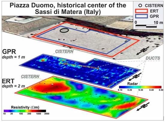
3.1. Piazza Duomo
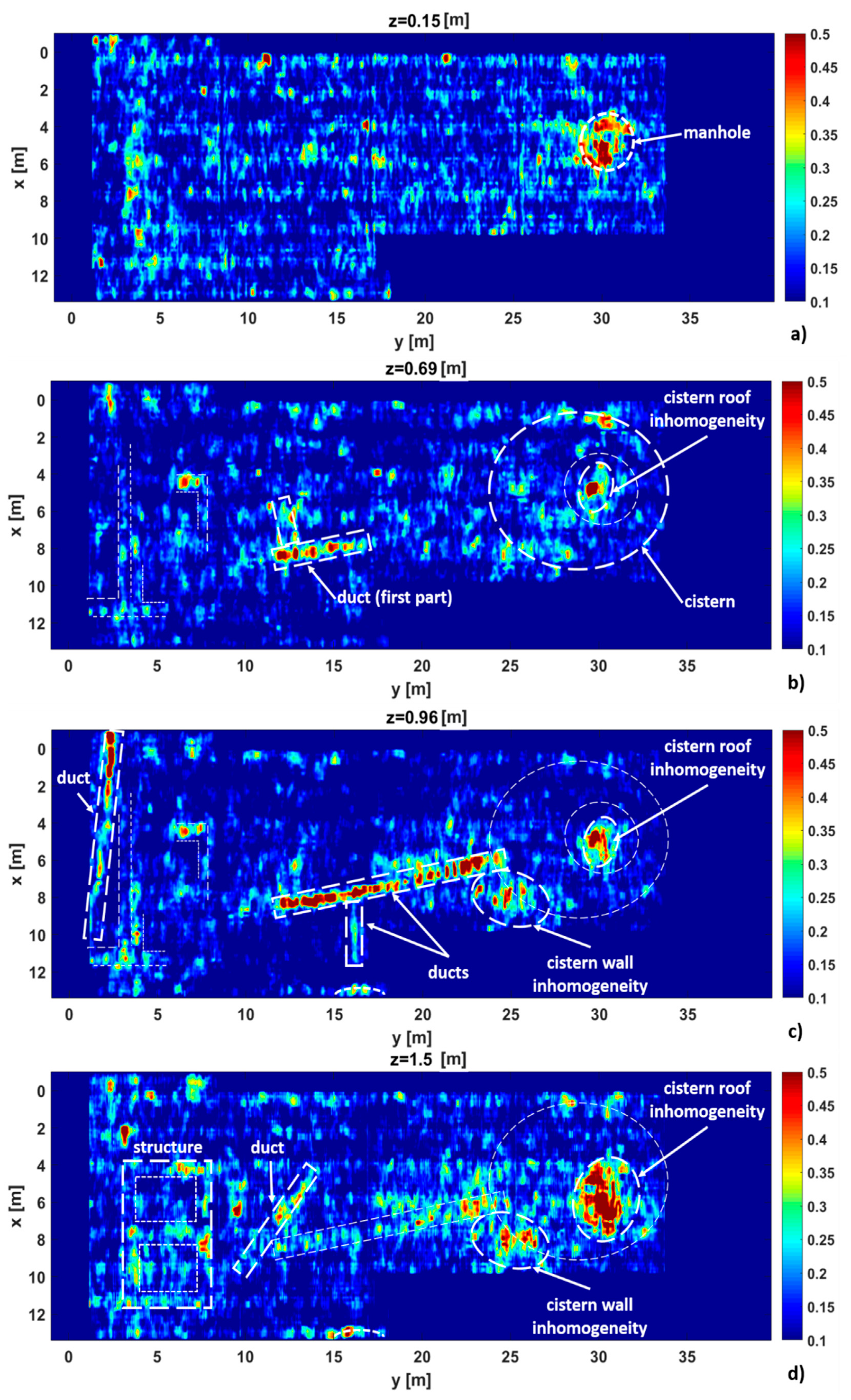
3.2. Piazza San Giovanni
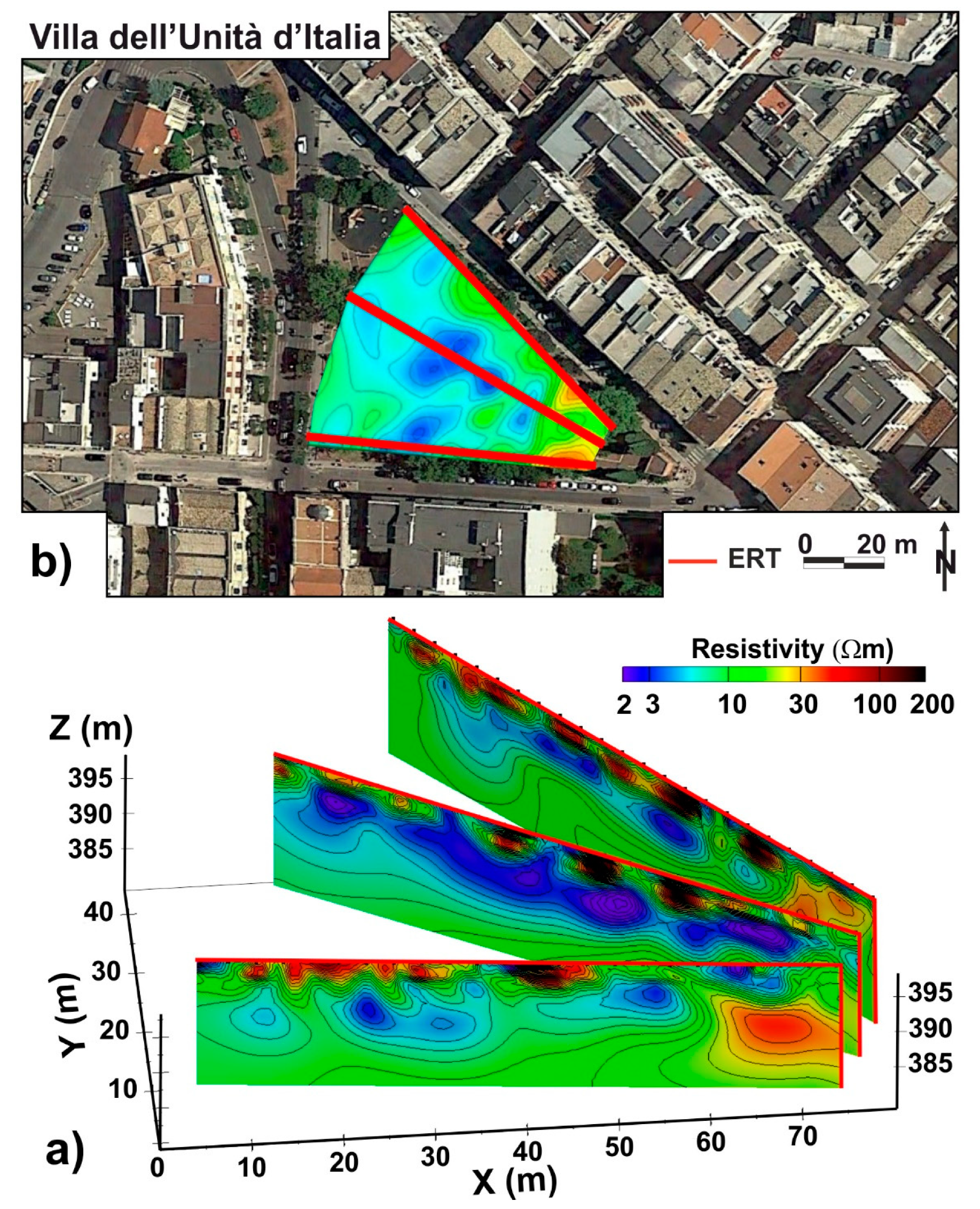
3.3. Villa dell’Unità d’Italia
- The presence of a 2–3-m thick shallow resistive layer (100–200 Ωm), that could be associated to filling material, locally affected by underground services;
- In all the ERTs, the occurrence of a very conductive layer (2–3 Ωm), probably related to alluvial silt deposits with remarkable water content;
- The existence at the bottom of a moderate resistivity layer (2–25 Ωm) correlated with the sub-Apennine clays;
- The identification, on the right of all the ERT images, of a sector with electrical resistivity values ranging in the interval 30–50 Ωm related to the calcarenite substratum in heteropic contact with the sub-Apennine clays, as reported in the geological map [30].
4. Conclusions
Author Contributions
Funding
Acknowledgments
Conflicts of Interest
References
- Meijer, A.; Bolivar, M. Governing the smart city: A review of the literature on smart urban governance. Int. Rev. Adm. Sci. 2016, 82, 392–408. [Google Scholar] [CrossRef]
- Trindade, E.P.; Hinning, M.P.; Moreira da Costa, E.; Sabatini Marques, J.; Cid Bastos, R.; Yigitcanlar, T. Sustainable development of smart cities: A systematic review of the literature. J. Open Innov. Technol. Mark. Complex. 2017, 3–11. [Google Scholar] [CrossRef] [Green Version]
- Salvia, M.; Cornacchia, C.; Di Renzo, G.C.; Braccio, G.; Annunziato, M.; Colangelo, A.; Orifici, L.; Lapenna, V. Promoting smartness among local areas in a Southern Italian region: The Smart Basilicata Project. Indoor Built Environ. 2016, 25, 1024–1038. [Google Scholar] [CrossRef]
- Desouza, K.C.; Flanery, T.H. Designing, planning, and managing resilient cities: A conceptual framework. Cities 2013, 35, 89–99. [Google Scholar] [CrossRef]
- Arafah, Y.; Winarso, H. Redefining smart city concept with resilience approach. IOP Conf. Ser. Earth Environ. Sci. 2017, 70, 012065. [Google Scholar] [CrossRef]
- Cuomo, V.; Soldovieri, F.; Ponzo, F.C.; Ditommaso, R. A holistic approach to long term SHM of transport infrastructures. In The International Emergency Management Society (TIEMS) Newsletter; THE International Emergency Management Society: Brussels, Belgium, 2018; pp. 67–84, ISSN 2033-1614. [Google Scholar]
- Showstack, R. Scientist call for a renewed emphasis on urban geology. EOS Earth Space Sci. News 2014, 47, 431–432. [Google Scholar] [CrossRef]
- Bobylev, N. Sterling, Urban underground space: A growing imperative perspectives and current research in planning and design for underground space use. Tunn. Undergr. Space Technol. 2016, 55, 1–4. [Google Scholar] [CrossRef]
- Bobylev, N. Underground space as an urban indicator: Measuring use of subsurface. Tunn. Undergr. Space Technol. 2016, 55, 40–51. [Google Scholar] [CrossRef] [Green Version]
- Lapenna, V. Resilient and sustainable cities of tomorrow: The role of applied geophysics. Boll. Geofis. Teor. Appl. 2017, 58, 237–251. [Google Scholar] [CrossRef]
- Laureano, P. Iscrizione alla Lista del Patrimonio Mondiale, Comune di Matera, I Sassi e il Parco delle Chiese Rupestri; Verso il Piano di gestione del sito UNESCO: Matera, Italy, 2012. [Google Scholar]
- Tropeano, M.; Sabato, L.; Festa, V.; Capolongo, D.; Casciano, C.I.; Chiarella, D.; Gallicchio, S.; Longhitano, S.G.; Moretti, M.; Petruzzelli, M.; et al. “Sassi”, the old town of Matera (southern Italy): First aid for geotourists in the "European Capital of Culture 2019. Alp. Mediterr. Quat. 2018, 31, 133–145. [Google Scholar] [CrossRef]
- Tropeano, M.; Sabato, L.; Pieri, P. Filling and cannibalization of a foredeep: The Bradanic Trough, southern Italy. Geol. Soc. Lond. Spec. Publ. 2002, 191, 55–79. [Google Scholar] [CrossRef]
- Beneduce, P.; Festa, V.; Francioso, R.; Schiattarella, M.; Tropeano, M. Conflicting drainage patterns in the Matera Horst area, Southern Italy. Phys. Chem. Earth 2004, 29, 717–724. [Google Scholar] [CrossRef]
- Festa, V.; Sabato, L.; Tropeano, M. 1:5000 geological map of the upper Cretaceous intraplatform-basin succession in the “Gravina di Matera” canyon (Apulia Carbonate Platform, Basilicata, southern Italy). Ital. J. Geosci. 2018, 137, 3–15. [Google Scholar] [CrossRef] [Green Version]
- Solimene, R.; Catapano, I.; Gennarelli, G.; Cuccaro, A.; Dell’Aversano, A.; Soldovieri, F. SAR Imaging Algorithms and some Unconventional Applications: A Unified Mathematical Overview. IEEE Signal Proc. Mag. 2014, 31, 90–98. [Google Scholar] [CrossRef]
- Persico, R. Introduction to Ground Penetrating Radar: Inverse Scattering and Data Processing; John Wiley & Sons: Hoboken, NJ, USA, 2014. [Google Scholar]
- Catapano, I.; Gennarelli, G.; Ludeno, G.; Soldovieri, F.; Persico, R. Ground-Penetrating Radar: Operation Principle and Data Processing. Wiley Encycl. Electr. Electron. Eng. 2019, 1–23. [Google Scholar] [CrossRef]
- Catapano, I.; Gennarelli, G.; Ludeno, G.; Soldovieri, F. Applying Ground-Penetrating Radar and Microwave Tomography Data Processing in Cultural Heritage: State of the art and future trends. IEEE Signal Process. Mag. 2019, 36, 53–61. [Google Scholar] [CrossRef]
- Catapano, I.; Ludeno, G.; Soldovieri, F.; Tosti, F.; Padeletti, G. Structural Assessment via Ground Penetrating Radar at the Consoli Palace of Gubbio (Italy). Remote Sens. 2018, 10, 45. [Google Scholar] [CrossRef] [Green Version]
- Bertero, M.; Boccacci, M. Introduction to Inverse Problems in Imaging; CRC Press: London, UK; Taylor&Francis Group: London, UK, 1998. [Google Scholar]
- Giocoli, A.; Hailemikael, S.; Bellanova, J.; Calamita, G.; Perrone, A.; Piscitelli, S. Site and building characterization of the Orvieto Cathedral (Umbria, Central Italy) by electrical resistivity tomography and single-station ambient vibration measurements. Eng. Geol. 2019, 260, 105195. [Google Scholar] [CrossRef]
- Moscatelli, M.; Piscitelli, S.; Piro, S.; Stigliano, F.; Giocoli, A.; Zamumer, D.; Marconi, F. Integrated geological and geophysical investigations to characterize the anthropic layer of the Palatine hill and Roman Forum (Rome, Italy). Bull. Earthq. Eng. 2014, 12, 1319–1338. [Google Scholar] [CrossRef]
- Pazzi, V.; Tapete, D.; Cappuccini, L.; Fanti, R. An electric and electromagnetic geophysical approach for subsurface investigation of anthropogenic mounds in an urban environment. Geomorphology 2016, 273, 335–347. [Google Scholar] [CrossRef] [Green Version]
- Rizzo, E.; Capozzoli, L.; De Martino, G.; Grimaldi, S. Urban geophysical approach to characterize the subsoil of the main square in San Benedetto del Tronto town (Italy). Eng. Geol. 2019, 257, 105–133. [Google Scholar] [CrossRef]
- Morelli, G.; Labrecque, D.J. Advances in ERT inverse modeling. Eur. J. Environ. Eng. Geophysics 1996, 1, 171–186. [Google Scholar]
- Novo, A.; Vinent, M.L.; Levy, T.M. Geophysical Surveys at Khirbat Faynan, an Ancient Mound Site in Southern Jordan. Int. J. Geophys. 2012, 2012, 8. [Google Scholar] [CrossRef] [Green Version]
- Sogliani, F. Archeologia urbana a Matera. In Dall’indagine stratigrafica alla condivisione dei dati: Lo scavo di S. Giovanni Battista-S. Maria La Nova. Mappa Data Book 1; Edizioni Nuova Cultura: Roma, Italy, 2015. [Google Scholar]
- Piscitelli, S.; Rizzo, E.; Cristallo, F.; Lapenna, V.; Crocco, L.; Persico, R.; Soldovieri, F. GPR and microwave tomography for detecting shallow cavities in the historical area of ‘‘Sassi of Matera’’(southern Italy). Near Surface Geophys. 2007, 5, 275–284. [Google Scholar] [CrossRef]
- Studio Geologico RU Matera. Studio Geologico Tecnico. Carta Geologica Centro Capoluogo Parte Nord. 2014. Available online: https://www.comune.matera.it/amministrazione-trasp/pianificazione-e-governo-del-territorio (accessed on 13 January 2017).


© 2020 by the authors. Licensee MDPI, Basel, Switzerland. This article is an open access article distributed under the terms and conditions of the Creative Commons Attribution (CC BY) license (http://creativecommons.org/licenses/by/4.0/).
Share and Cite
Bellanova, J.; Calamita, G.; Catapano, I.; Ciucci, A.; Cornacchia, C.; Gennarelli, G.; Giocoli, A.; Fisangher, F.; Ludeno, G.; Morelli, G.; et al. GPR and ERT Investigations in Urban Areas: the Case-Study of Matera (Southern Italy). Remote Sens. 2020, 12, 1879. https://doi.org/10.3390/rs12111879
Bellanova J, Calamita G, Catapano I, Ciucci A, Cornacchia C, Gennarelli G, Giocoli A, Fisangher F, Ludeno G, Morelli G, et al. GPR and ERT Investigations in Urban Areas: the Case-Study of Matera (Southern Italy). Remote Sensing. 2020; 12(11):1879. https://doi.org/10.3390/rs12111879
Chicago/Turabian StyleBellanova, Jessica, Giuseppe Calamita, Ilaria Catapano, Alessandro Ciucci, Carmela Cornacchia, Gianluca Gennarelli, Alessandro Giocoli, Federico Fisangher, Giovanni Ludeno, Gianfranco Morelli, and et al. 2020. "GPR and ERT Investigations in Urban Areas: the Case-Study of Matera (Southern Italy)" Remote Sensing 12, no. 11: 1879. https://doi.org/10.3390/rs12111879
APA StyleBellanova, J., Calamita, G., Catapano, I., Ciucci, A., Cornacchia, C., Gennarelli, G., Giocoli, A., Fisangher, F., Ludeno, G., Morelli, G., Perrone, A., Piscitelli, S., Soldovieri, F., & Lapenna, V. (2020). GPR and ERT Investigations in Urban Areas: the Case-Study of Matera (Southern Italy). Remote Sensing, 12(11), 1879. https://doi.org/10.3390/rs12111879


