Article

Unprecedented Temporary Reduction in Global Air Pollution Associated with COVID-19 Forced Confinement: A Continental and City Scale Analysis

1
Department of Geography, University of Connecticut, Storrs, CT 06269, USA
2
Key Laboratory of Digital Earth Science, Aerospace Information Research Institute, Chinese Academy of Sciences, Beijing 100094, China
3
University of Chinese Academy of Sciences, Beijing 100049, China
4
Department of Irrigation and Drainage, University of Agriculture Faisalabad, Faisalabad 38040, Pakistan
*
Author to whom correspondence should be addressed.
Remote Sens. 2020, 12(15), 2420; https://doi.org/10.3390/rs12152420
Submission received: 22 June 2020 / Revised: 24 July 2020 / Accepted: 27 July 2020 / Published: 28 July 2020
(This article belongs to the Section Atmospheric Remote Sensing)

Abstract

:
Shortly after the outbreak of the novel infectious disease (COVID-19) started at the end of 2019, it turned into a global pandemic, which caused the lockdown of many countries across the world. Various strict measures were adopted to reduce anthropogenic activities in order to prevent further spread and infection of the disease. In this study, we utilized continental scale remotely sensed data along with city scale in situ air quality observations for 2020 as well as data from the baseline period (2015–2019) to provide an early insight on air pollution changes in response to the COVID-19 pandemic lockdown, by combining both continental and city scales. For the continental scale analysis, data of NO2, SO2, and O3 were acquired from the ozone monitoring instrument (OMI) and data of aerosol optical depth (AOD) were collected from the moderate resolution imaging spectroradiometer (MODIS). For city scale analysis, data of NO2, CO, PM2.5, O3, and SO2 were derived from ground-based air quality observations. Results from satellite observations at the continental scale showed that concentrations of NO2, SO2, and AOD substantially dropped in 2020 during the lockdown period compared to their averages for the baseline period over all continents, with a maximum reduction of ~33% for NO2 in East Asia, ~41% for SO2 in East Asia, and ~37% for AOD in South Asia. In the case of O3, the maximum overall reduction was observed as ~11% in Europe, followed by ~10% in North America, while a slight increase was found in other study regions. These findings align with ground-based air quality observations, which showed that pollutants such as NO2, CO, PM2.5, and SO2 during the 2020 lockdown period decreased significantly except that O3 had varying patterns in different cities. Specifically, a maximum reduction of ~49% in NO2 was found in London, ~43% in CO in Wuhan, ~38% in PM2.5 in Chennai, and ~48% in SO2 in Beijing. In the case of urban O3, a maximum reduction of ~43% was found in Wuhan, but a significant increase of ~47% was observed in Chennai. It is obvious that restricted human activities during the lockdown have reduced the anthropogenic emissions and subsequently improved air quality, especially across the metropolitan cities.

Graphical Abstract

1. Introduction

According to current estimations, the global population has reached about 7.8 billion and continues to increase by more than 81 million people per year in recent years [1]. The fast-growing population around the world increases pressure on daily anthropogenic activities such as industrial and processing activities [2,3] to fulfill the daily demands of more food, shelter and other services [4,5], which subsequently threatens the sustainability of the global ecosystem [6,7]. Nowadays, more than 55% of the global population is living in metropolitan areas [8]. Along with the population boost, power generation, industrialization, transport demand, and transport quantities have also been increasing. Massive anthropogenic emissions from these sectors have resulted in various environmental issues in terms of harmful effects on human health [9,10,11], worsened outdoor air quality [12,13], and an altered climate system [14,15]. In the list of the world’s most polluted cities, most of the top 30 most polluted cities are located in Asia, especially in India, Pakistan, and China [16,17,18,19,20,21]. One of many causes leading up to outdoor air pollution is that the developing countries around the world do not adopt the standard operating protocols to run industrial units [22]. Another cause is the use of low-quality fuel in transport vehicles, which consequently releases various air pollutants to the atmosphere [23,24,25,26]. In the major metropolitan cities, nitrogen dioxide (NO2), sulfur dioxide (SO2), particulate matters (e.g., PM2.5, and PM10), tropospheric ozone (O3) and carbon monoxide (CO) are among the foremost vulnerable air pollutants [27,28,29]. SO2 is mainly induced by natural phenomenon (volcanoes) and anthropogenic sources such as the burning of fuels, power generation, and metal smelting [30]. Its presence in the low troposphere can degrade air quality and is also a precursor gaseous source of sulfate aerosols that can further affect the cloud reflectivity [31]. In the atmosphere, presence of hydrogen peroxide (H2O2) and O3 can predominantly oxidize the SO2 in the aqueous phase to formulate sulfuric acid (H2SO4), which can further lead to particulate sulfate [31]. Moreover, sulphates are key components of particulate matters (PM2.5) and compose 11%–65% of aerosol mass [32]. Combustion of fossil fuels in industries, transportation and other human sectors lead to the formation of NO2 [33], which can further play an important role as a catalyst in tropospheric O3 formation and serve as a precursor of inorganic aerosols (PM2.5) [10,34,35]. Several legislations have been implemented over the past several years to reduce the air pollution around the globe; however, the current air pollution level is still exceeding the World Health Organization (WHO) air quality standards over most major metropolitan cities.
On the other hand, the outbreak of COVID-19 that started in late December of 2019, spread quickly to many countries (212 countries and territories) over the world and eventually turned into a global pandemic [36,37,38,39,40]. The World Health Organization had to declare a global health emergency on 30 January 2020 [41,42]. Many major human activities, in the areas of culture, education, transportation, and industrial manufacturing were constrained globally [43,44] to prevent the further spread of COVID-19 disease [45,46,47,48]. The ongoing restrictions of anthropogenic activities in many countries have largely reduced the industrial production as well as energy consumption by 30% or so within a few weeks, as strict lockdown measures were imposed for public health concerns [49,50]. Restricted human activities during the pandemic lockdown have reduced the emissions of pollutants into the atmosphere [51] and thus decreased the pollution level across the global metropolitan cities [52,53]. This provides a unique chance to investigate the impacts of these restricted anthropogenic emissions on air quality, as well as to better understand the complex response of the atmospheric environment to anthropogenic activities.
Ground-based air quality observations provide accurate estimates of mass concentration of air pollutants but are short of spatial representativeness, which restricts our understanding of air pollution changes in response to COVID-19 pandemic lockdown at the continental scale. To better address this problem, satellite observations along with ground-based data during COVID-19 pandemic lockdown at continental and city scales—as indicated in other studies [54,55]—can provide a unique chance to detect real-time changes in air pollution globally. Moderate resolution imaging spectroradiometer (MODIS) and ozone monitoring instrument (OMI) have facilitated the observation of particulate matters and pollutants at high spatial and temporal resolutions [56,57]. Mass concentrations of air pollutants observed from these space missions revealed a significant reduction in NO2, SO2, and PM2.5, coinciding with the strict quarantine measures, as was pointed out by some recent publications [44,58,59,60,61]. Recent imageries from MODIS on Terra satellite launched by the National Aeronautics and Space Administration (NASA) reported a reduction in aerosol optical depth (AOD) over Asia in April (2020) compared with its average over past years [44]. However, certain limitations did exist in the aforementioned studies. For example, most of these studies analyzed the changes in the mass concentration of air pollutants in 2020 by comparing with the data of just the previous year, 2019, as a baseline, which may be subject to the effects of inter-annual climatic variability and bring uncertainty in results. Therefore, there is a critical need to consider the data from the past several years as a baseline to reduce the effects of inter-annual climatic variability. Moreover, most studies were conducted on a regional scale rather than on a global scale.
This study compiled the global scale data from multi missions of satellites (MODIS and OMI) along with city scale data from ground-based air quality observations to investigate the changes of air pollution in response to the COVID-19 pandemic lockdown by comparing 2020 data from the lockdown period with the baseline period (2015–2019). By combining continental scale and city scale data, we formed a scale hierarchy for a more detailed analysis on the impact of the COVID-19 induced global lockdown on air quality. The main objective of this study is to shed light on uneven changes in air pollution under the potential effects of restricted human activities during the lockdown period.

2. Materials and Methods

2.1. Study Area

This study was carried out over a global scale, especially covering three main continents: North America, Europe, and Asia. We did not include South America and Africa because from our examination on satellite retrieved data, the abnormal change in these two continents is not as significant as other continents. Therefore, we mainly focused on ten countries: Three countries from South Asia (Pakistan, India, and Bangladesh), one from East Asia (China), five from Europe (Spain, France, Italy, Germany, and the UK) and one from North America (United States of America). In Figure 1a, dots drawn in red color show the locations of countries selected in this study. In order to investigate air pollution changes at the city scale, we selected 16 major metropolitan cities around the world based on (i) the historical level of air pollution in the city, (ii) emission sources of pollution, (iii) geographical setting, (iv) COVID-19 cases in that city, (v) the city lockdown history, (vi) NASA evidence on effects of national lockdown on city pollution and (vii) population density among others. Figure 1b illustrates the origins and spatial distributions of different types of emission sources in the world. Most of the air pollution in selected study regions is mainly induced by transport, smelter, oil, gas, and power plants. Figure 1c highlights the dates of lockdown and severity restricted internal movement by countries.

2.2. Ground-Based Air Quality Monitoring

For the city scale analysis of air quality, data of five main pollutants, NO2, CO, PM2.5, O3, and SO2, were used to investigate the changes in air quality over metropolitan cities before and after the lockdown measures. Air quality data of these pollutants were obtained from World’s Air Pollution: Real-time air quality index (WAQI project, https://aqicn.org/). These data were compiled from more than 12,000 ground-based monitoring stations, spatially distributed over 1000 major cities in more than 100 countries in the world. New dedicated worldwide COVID-19 datasets of air quality, updated 3 times a day, and covering about 380 major cities in the world were also collected from Air Quality Open Data Platform (available at aqicn.org/data-platform/covid19/). However, some air quality parameters are missing from the WAQI project, especially for North America. Therefore, in order to fill in the gap of missing data, we collected air quality data of PM2.5, NO2, and CO from the United States Environmental Protection Agency (EPA) (available at www.epa.gov/outdoor-air-quality-data/).
In the present study, we used the daily concentration of five pollutants (NO2, CO, PM2.5, O3 and SO2) from 1 January–15 May for the year of 2015–2019 (defined as baseline period) and 2020, for sixteen selected cities located in South Asia, East Asia, Europe, and North America (Figure 1a). The pre-assumption behind the baseline period was that the air quality in this period mainly responded to regular conditions of anthropogenic emissions while changes in the air quality during January–May 2020 was caused primarily by effects of country-specific lockdown measures when most of the anthropogenic activities were stopped [51,55,62]. Also, using past multi-year data as baseline helps to reduce the effects of inter-annual climatic variability in air pollution [63]. Therefore, we compared the air quality data of the baseline period (2015–2019) with the data of 2020 in the same time frame to shed light on uneven improvement in the air quality under strict lockdown measures.

2.3. Space Observations Data

Satellites in space provide global observation data for air quality monitoring over the Earth. For continental scale analysis, we used global datasets of tropospheric NO2, SO2, O3, and AOD. Tropospheric NO2, SO2, and O3 data were collected from OMI onboard the NASA Aura satellite, available from October 2004 to present. OMI sensor provides the measurement of backscattered radiations from the Earth’s surface as well as atmosphere layer with a spectral resolution of ~0.5 nm, wavelength range from 270 to 500 nm, and spatial resolution of 13 × 24 km2, at daily global coverage [64]. Scientific applications of OMI sensors provide data in monitoring tropospheric pollution of pollutants like SO2, NO2, and O3. We used the gridded products of OMI/AURA satellite, (1) the planetary boundary layer (PBL) SO2 vertical column density (OMSO2.v003), (2) tropospheric NO2 (OMNO2d.v003) and (3) total ozone columns (OMDOAO3.v003). The original OMI PBL SO2 products have a high noise level [65,66]; therefore, a new operational OMI PBL SO2 product produced with the principal component analysis (PCA) algorithm was used, because it performed better with smaller bias [67].
The tropospheric NO2 columns and total ozone column observations were retrieved from OMI based on the differential optical absorption spectroscopy (DOAS) technique within 405–465 nm [68,69,70,71]. Moreover, detailed description of the DOAS analysis and algorithm, data filtering, and quality control methods are available at http://disc.gsfc.nasa.gov/Aura/OMI/. On a global scale, the average uncertainty between OMI retrieved columns and ground-based column observations was found to be less than 2% [72], however, the relative difference can be larger at individual stations [73]. NO2 (OMNO2d.003) data were used due to the improved algorithms and sensitivity of OMI for NO2 detection at the lower atmosphere. It has been found that there is good agreement between in situ measurements and OMI satellite observations for NO2 [67,74,75], SO2 [67,76], and for O3 [69,77,78,79]. In the present study, daily records of standard Level 3 OMI grid products at 0.25-degree resolution were acquired globally for the period of 1 January–15 May (2015–2020) from the NASA Goddard Earth Sciences (GES) Data and Information Services Center (DISC).
MODIS onboard NASA’s Terra and Aqua satellites provides dataset to monitor AOD and the size distribution of the ambient aerosol. AOD is retrieved using two algorithms dark target (DT) and deep blue (DB) [80,81,82]. Several improved algorithms have been incorporated in the latest MODIS collections (V6.1) to mitigate the uncertainties as compared to previous products [83,84,85]. Detailed descriptions about aerosol products, aerosol retrieval, calibration procedure, and uncertainties can be found in the literature [86,87,88]. It has been well established that both MODIS DT and DB AOD measurements at 550 nm are in good agreement with ground observations [87,89]. In this study, latest records of daily AOD (MOD08_D3) at 550 nm of MODIS onboard NASA’s Terra sensor were acquired globally at 1° × 1° spatial resolution for the period of 1 January–15 May (2015–2020) from the NASA GES DISC. A detailed description of satellite products used in this study is listed in Table 1.

2.4. Supplementary Data

Mobility index data of different human activities were tracked from Google reports covering January–May 2020 to understand the anthropogenic changes caused by the pandemic lockdown as well as the lockdown scenario in different countries. Time series datasets of COVID-19 were collected from WHO concerning the COVID-19 cases, numbers of death and the recovered since the epidemic started [42].

2.5. Methods

Daily data of tropospheric NO2, SO2, O3, and AOD were processed using NASA Giovanni user interface. Giovanni is a web application that provides a simple, intuitive way to visualize, analyze, and access Earth science remote sensing data, particularly from satellites. Time series maps were made from daily acquired data for January–April, averaged over the past years during 2015–2019, as the baseline data and compared with the data of the same dates from 2020 in different lockdown scenarios. Daily time series of tropospheric NO2, SO2, O3, and AOD averaged over selected regions were acquired using NASA Giovanni from 1 January–15 May. Daily anomaly changes were computed using absolute difference, of which the formula was shown as follows:
Anomaly = Daily values (2020) − Daily values (averaged over 2015–2019)
Daily concentration of ground-based air quality data acquired from the United States Environmental Protection Agency (EPA) was usually expressed in mass density. Therefore, the following standard equations were applied to convert the concentration of mass density into volume mixing ratio:
Concentration (mg/m3) = concentration (ppm) × (molecular mass/molar volume)
Concentration (ug/m3) = concentration (ppb) × (molecular mass/molar volume)

3. Results

In this section, satellite observation and ground-based air quality data along with some supplementary data (COVID-19 and mobility) were analyzed to understand changes of global air pollution from a spatial and temporal point of view (both continental and city scale) in response to COVID-19 lockdown measures. The time series of data averaged on 1 January–15 May from 2015 to 2019 as baseline were compared with the data derived from the same duration in 2020. For the continental scale analysis of perspective pollutants, the results averaged over the area were used, while for the city level analysis the averaged time series data from different ground-based air quality monitoring stations in the specific city were used to explore the air pollution changes in response to COVID-19 lockdown.

3.1. COVID-19 Pandemic Lockdown and Anthropogenic Mobility

Time series of COVID-19 pandemic along with mobility index of different human activities were adopted to investigate the impacts of pandemic lockdown stages on human activities. The outbreak of COVID-19 started in late December of 2019. At the beginning stage, COVID-19 cases were mainly detected in Asian countries. But a few weeks later, it turned into a global pandemic and started to spread not only in Asia but also in other countries (Figure 2a). The World Health Organization (WHO) reported that the COVID-19 cases recorded in America were as high as 3,234,875 followed by Europe recorded as 2,268,311 until 4 June, 2020 [90]. With the rapid spread of COVID-19, strict lockdown measures were imposed by more and more countries all over the world to prevent the massive infections of the virus between people. Figure 2b illustrates the changes in mobility index with time in terms of different human activities for 9 of the 10 countries selected for this study. The Google mobility index divides usual mobility activities into different specific categories as follows: Retail and recreation, grocery and pharmacy, transit stations, workplaces, residential, and park. It can be observed clearly that all the activities including transport, industries, social places, and educational sectors were running normally before lockdown, but after the lockdown was imposed, the mobility index of human activities decreased by a large extent while the mobility index for residential increased since the lockdown began. The decline of mobility index for the selected countries was observed as 70–90% in workplaces followed by 60–85 % in transit stations till 25 May, 2020 since the pandemic started. However, the UK, France, Spain, and Italy exhibited larger drops in these activities.

3.2. Change in Air Pollution at Global and Continental Scale from Satellite Observations

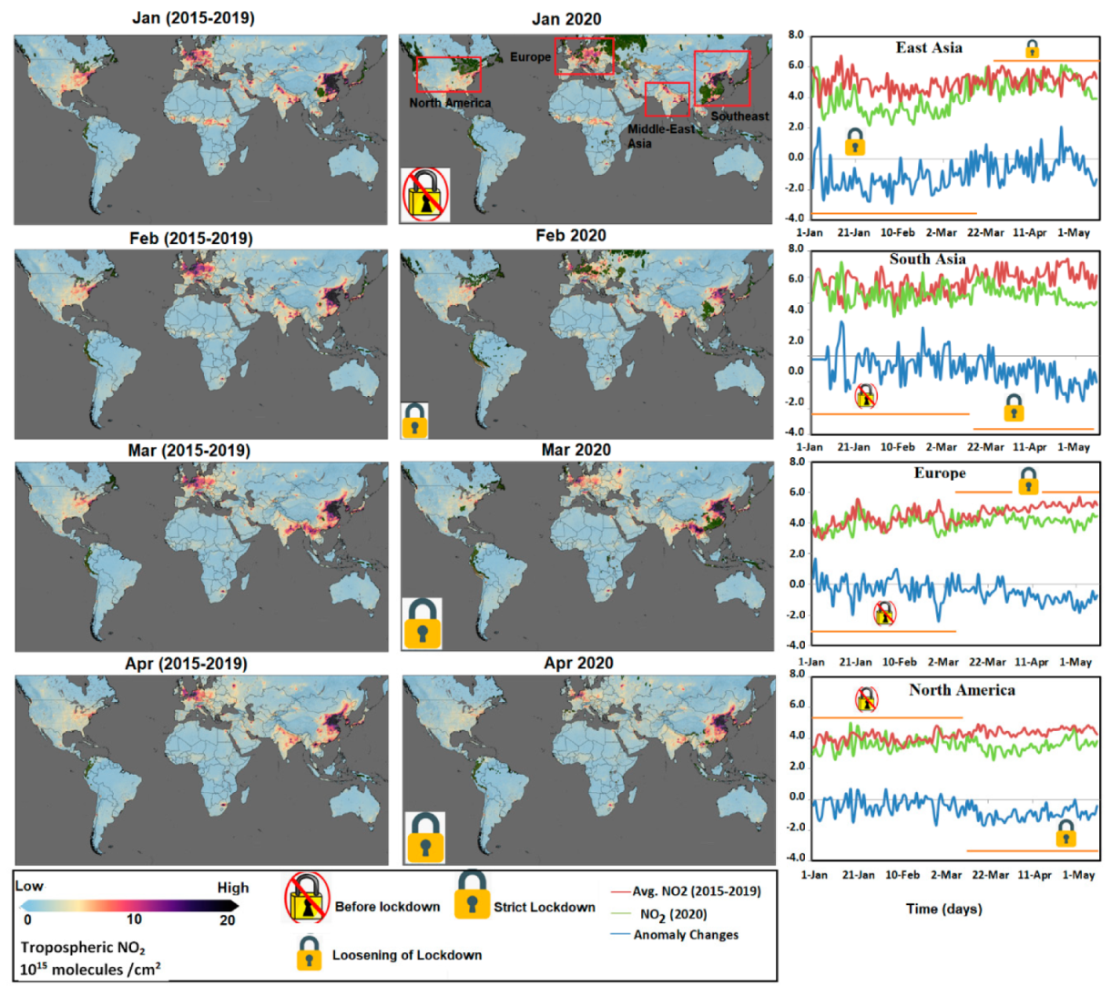
Spatial-temporal variations of airborne NO2 before and after lockdown in 2020 compared with the baseline are presented in the left two columns of Figure 3. The right column in Figure 3 illustrates the comparison of daily averaged time series data during the baseline period with the daily data from the same dates of 2020. The maps of the NO2 concentration clearly exhibit that the highest level of NO2 concentration appeared in East Asia and Europe in contrast to a relatively lower level of NO2 concentration in South Asia and North America. Moreover, the NO2 pollution level is very unevenly distributed throughout East Asia as well as over North America. However, the NO2 level is more evenly distributed over South Asia and Europe. A higher level of NO2 observed over Europe can be explained by higher contributions from transport sectors, since the transport sector is considered as the largest contributor to NOx emissions in European cities [91]. The higher NO2 level over Asia and Europe probably can be attributed to the contribution of NOX emissions, 40% of which is from automobile exhaust and road transport [92]. Seven compounds are contained within the NOX family, but EPA only regulates NO2 as a surrogate for its family. The reason is that the most prevalent form of NOX in the atmosphere generated by anthropogenic activities is NO2 [93]. Spatial maps clearly reveal that the level of NO2 has largely decreased in the 2020 lockdown period, especially from March–Apr 2020 compared to the baseline period. For example, in Europe, an NO2 level of about 10 to 20 (1015 molecules/cm2) was observed in an extensive area over European countries (Spain, France, Italy, Germany, and the UK) during March–April in the baseline period. While in 2020, during the lockdown period (March–April), not only the NO2 emission level was reduced to about 10 (1015 molecules/cm2) but also its spatial extent largely decreased over all countries studied.
It is clear from time series graphs that NO2 level before the lockdown period in 2020 was showing a similar behavior in fluctuation trend as it was in the baseline period, while after the lockdown was imposed, time series of mean NO2 began to drop down compared to the baseline level. Moreover, it can also be observed that anomaly variations in NO2 before the lockdown were fluctuating with positive (increasing trend) and negative (decreasing trend) values around the zero baseline (gray line), while after the lockdown was imposed, it showed negative values continuously below the baseline due to strict lockdown measures. One interesting finding is observed in East Asia (mainly in China), where we can see a significant decline of NO2 between January to March followed by a sharp increase to the same emission level as averaged in previous 5 years, which is associated with the lockdown being lifted starting from mid-March [61]. The decline in the NO2 emission level is generally associated with the local mobility trend.
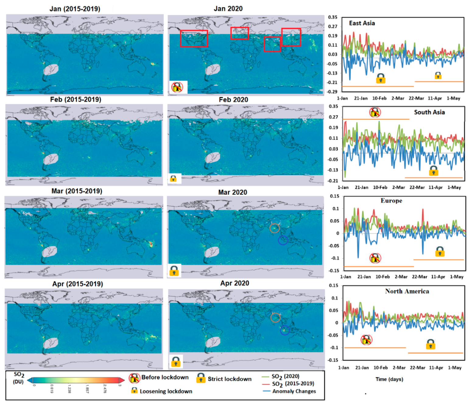
Figure 4 exhibits the spatial and temporal variations of SO2 compared with the baseline before and after lockdown in 2020. SO2 is measured by the Dobson unit (DU), which is a unit of the amount of gas measured in a vertical column through the Earth’s atmosphere. We can see that in general, a higher level of SO2 emission was found in East and South Asia regions compared to other regions, followed by Europe. The high level of SO2 in East and South Asia regions is related to the abundant power plants and smelters, as shown in Figure 1b. Spatial maps of SO2 show a substantial reduction, especially over South Asia and Europe during the lockdown (March–April 2020) compared to the baseline. For example, in South Asia (marked with a brown circle in Figure 4), SO2 hotspots can be clearly observed with concentration > 1.5 DU in March of 2020 (before the strict lockdown) while these hotspots disappeared due to the reduction of SO2 level to < 0.6 DU in April of 2020 (during the strict lockdown). Variation of SO2 emission over the Sumatra region (marked with a blue circle in Figure 4) was almost invisible from January–March of 2020. However, in April 2020, some visible spots of SO2 emissions can be seen over the Sumatra region, which may reflect the unusual weather conditions in April 2020. As shown in Figure 1b, Sumatra lies in a volcanic region and SO2 air pollution is mainly induced by volcanic activities caused by climatic variations due to its unique location near to the Indian Ocean. From daily variations of SO2 level, we can also find that reduction in SO2 is related to lockdown status which is more significant over the two Asia regions compared to Europe and North America.
Figure 5 exhibits the spatial and temporal variations of the total ozone column (O3) compared with the baseline level during 2015–2019 before and after lockdown in 2020. These maps reveal that the spatial extent and magnitude of O3 over the North Americas and Europe significantly reduced during March–April 2020 (lockdown period) compared to the baseline. It can be seen that O3 level over North America was close to the baseline level during January–February, 2020. But from March–April, a significant decline of O3 occurred. For example, in April (2015–2019) O3 level was more than 370 DU over North America while in April (2020) it reduced to less than 310 DU. However, a substantial increase of O3 was observed for the period of March–April of 2020 over the South Asia region (Mainly India and Pakistan). Daily time series of average O3 and its anomaly during February–March 2020 (before lockdown in most countries) fluctuated around their respective baselines (for the anomaly, its baseline is the black dot line at zero) over North America and Europe. However, after the lockdown was imposed, a sharp decline was observed as the anomaly fluctuated below the baseline level during this period. In the case of South Asia, the time series of average O3 was above the baseline level and the anomaly was increasing during January–April (2020). However, it decreased to the baseline level after the lockdown was imposed in those countries of the region. For example, from 1 January–20 March, O3 anomaly time series could reach 29 DU but after the lockdown was imposed from 20 March, it declined to 5 DU on the 15th May.
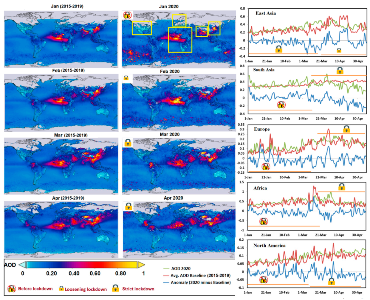
Figure 6 presents the spatial and temporal variations of AOD before and after lockdown in 2020 compared with the baseline. AOD maps clearly depict that its spatial extent and magnitude were much higher in East Asia, South Asia, and Africa compared with Europe and North America. No significant changes in AOD were found over North America and Europe before and after the lockdown period since the values of AOD were already too low over these two regions. It seems that lockdown did not pose significant effects on AOD in Europe and North America but had more influence over the two Asia regions. In South Asia, the spatial extent of the AOD level as well its magnitude was higher during January–February, 2020 (before lockdown) with a value > 0.8 but dropped to < 0.6 in March–April 2020 during the lockdown. The daily mean AOD dataset and its anomaly changes in South Asia show that during the first 10 weeks of 2020 the AOD was increasing, but it abruptly decreased right after the lockdown was imposed. In East Asia, traditional Chinese New Year is usually around mid-January to late February each year, which often causes a decline in emissions, the average level of AOD in the past years over this duration was relatively low. Therefore, no significant decline of AOD in these two months of 2020 was observed. But from March, when Chinese New Year is usually over, the AOD level often increases as shown by the baseline but we can see a clear decline of AOD level after Chinese New Year in 2020. We can also see a significant surge in the AOD level after the lockdown was partially lifted in East Asia (mainly China) [61] around April.
Table 2 summarizes the averaged NO2, AOD, O3, and SO2 levels from January to April of 2020 compared to the baseline at a continental scale. This table shows percentage reductions of air pollutants during the pandemic lockdown, which were calculated and compared to baseline values to infer how much the data in 2020 increased (+) or decreased (−) compared to baseline. Continental scale data depict the maximum amount of reduction in NO2 to be ~33% (East Asia), in SO2 to be ~41% (East Asia) and in AOD to be ~37% (South Asia). In the case of O3, the maximum reduction was ~11% (Europe), followed by ~10% (North America) while in other regions it increased slightly. We can see that in general, lockdown has posed significant impacts on the decline of pollutants like NO2 and SO2, as well as AOD. But O3 appeared not to be affected as much by the reduction of human activity during the lockdown as the other three indicators. Even after strict lockdown, the O3 level only declined slightly relative to baseline but for some regions, it increased. This was probably related to the combined factors triggered by abnormal weak upper atmospheric wave events from December 2019 to March 2020 as reported by NASA. Note that the total column ozone is used for the continental scale analysis for O3, which could also partially lead to our finding. Ground-based observation data lack spatial representative and cannot be used to cover large areas such as continental scale, so a remote sensing approach is required when it comes to continental scale data analysis.

3.3. Change in Air Pollution at City Scale from Ground-Based Observations

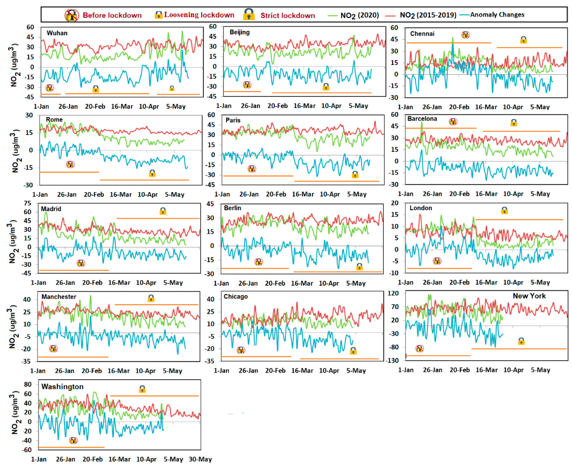
For city scale analysis of air quality, ground-observed data of five main air pollutants NO2, CO, PM2.5, O3, and SO2 were used to investigate the changes of air quality in metropolitan cities before and after lockdown. Since some data of five main air pollutants for some cities are still missing, we ignored those pollutants of those cities in graphs. Figure 7 illustrates the daily mean NO2 dataset and its anomaly changes observed from January to May of 2020 compared to the baseline over the different global metropolitan cities.
It can be seen that all cities showed a significant drop in mean emission of NO2 and its anomaly after the lockdown was imposed in these cities, however, reduction in Madrid, Rome, Barcelona, Berlin, and Wuhan were relatively larger. Before lockdown, human activities were running normally in terms of both normal daily activities and emitting pollutants, which should be the reason why time series of anomaly changes were fluctuating around the zero line. However, after the strict lockdown measures were imposed, abrupt reduction of human activities during pandemic lockdown resulted in sharp decreases in NOx emissions and thus time series of anomaly changes moved down below the baseline continuously. For those cities that were severely impacted by COVID-19 and strict measures for lockdown were imposed, dramatic drop of emissions during lockdown and rapid increase of emissions shortly after the lockdown was gradually lifted can be seen clearly from the figure, such as Wuhan and Beijing.
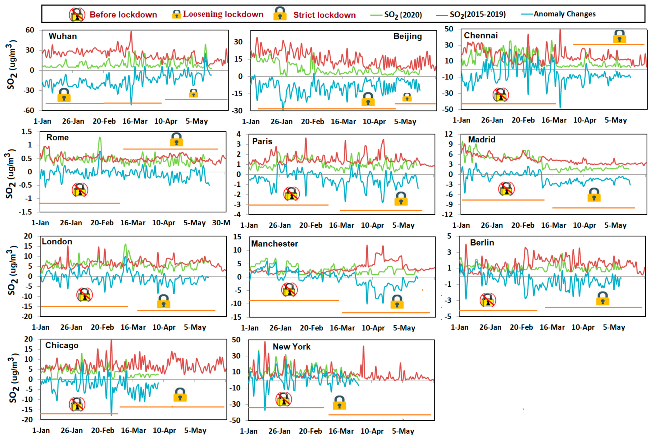
Figure 8 shows the daily mean SO2 changes in different major cities from January to May of 2020 compared to the baseline. For the labels in the figure please refer to the explanations for Figure 7 of NO2. Quite similar to the variations of NO2 in terms of daily mean as well as anomaly, for most cities, such as Wuhan and Beijing, Madrid, Chicago, Chennai, and Paris, lockdown immediately resulted in significant decrease of SO2 emission. However, for cities like Rome, and London, there were only very slight decline in SO2 even after the lockdown was imposed, because the emissions level of SO2 was relatively low in these regions over the past years.
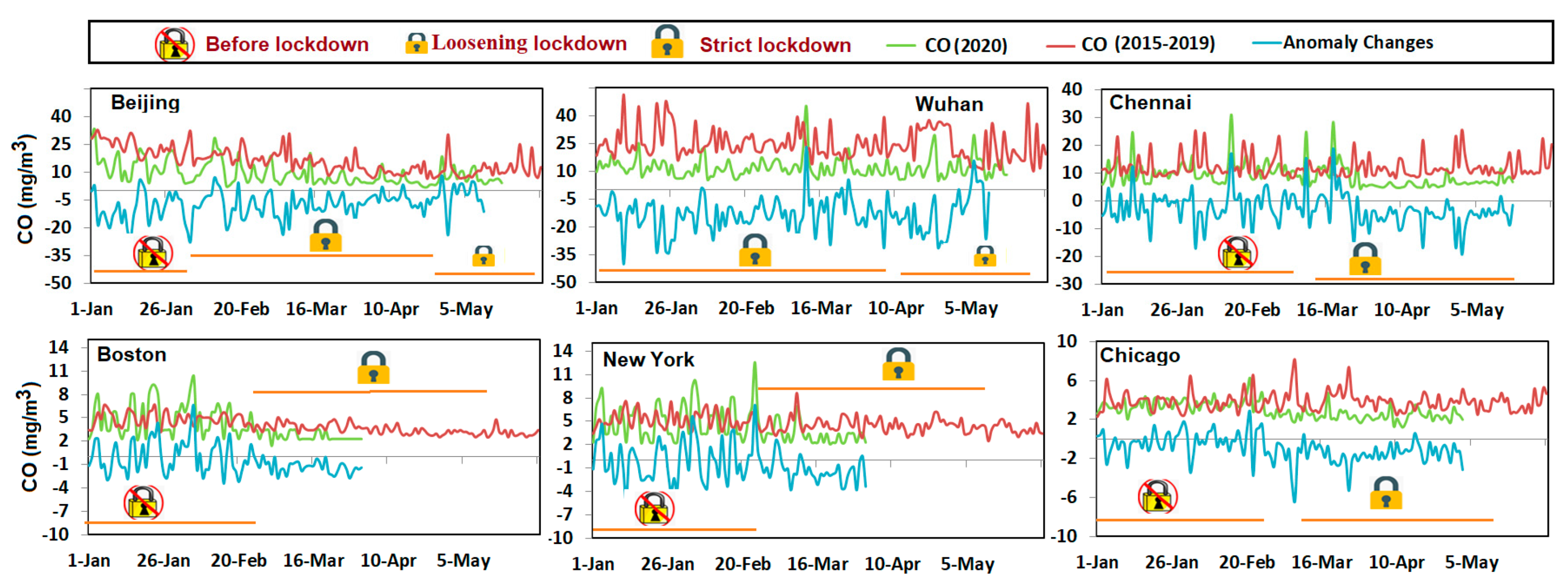
Figure 9 plots the daily mean variations of CO and its anomaly changes in different major cities from January to May of 2020 compared to the baseline. Since the CO data are not sufficiently available as the data of other pollutants for our chosen metropolitan cities, only six cities with available data were taken as examples in this study. Decrease of CO was found for all studied cities after lockdown, the declining trend is obvious for Beijing, Wuhan, and Chennai probably owning to more CO related emissions. The CO concentration in Wuhan was about 6 times higher than that averaged in Chicago, but both declined approximately 40% after lockdown. An increasing trend in CO anomaly compared to baseline before the lockdown period was found for cities like Boston, New York, and Chicago. After the lockdown was imposed, slight decrease in CO level appeared over these cities.
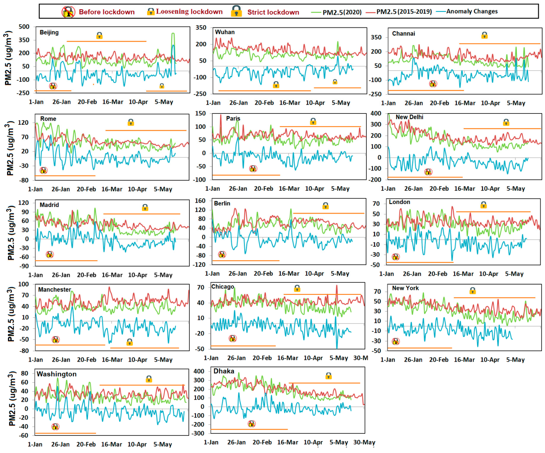
Figure 10 plots the daily mean dataset of PM2.5 and its anomaly changes compared to the baseline from January to May of 2020 over different major cities. In general, PM2.5 fluctuated obviously between different cities. The concentration of PM2.5 dropped considerably from 38.19% to 16.90% compared to the baseline during pandemic lockdown for all major cities presented in the graph. Before lockdown, the PM2.5 in 2020 over most cities overlapped with the baseline, which implies that PM2.5 pollution levels were similar between 2020 and 2015–2019 before lockdown. But after lockdown, the daily PM2.5 in 2020 was lower than the baseline. Cities in Asia decreased more significantly in PM2.5 after lockdown than those major cities in North America and Europe.
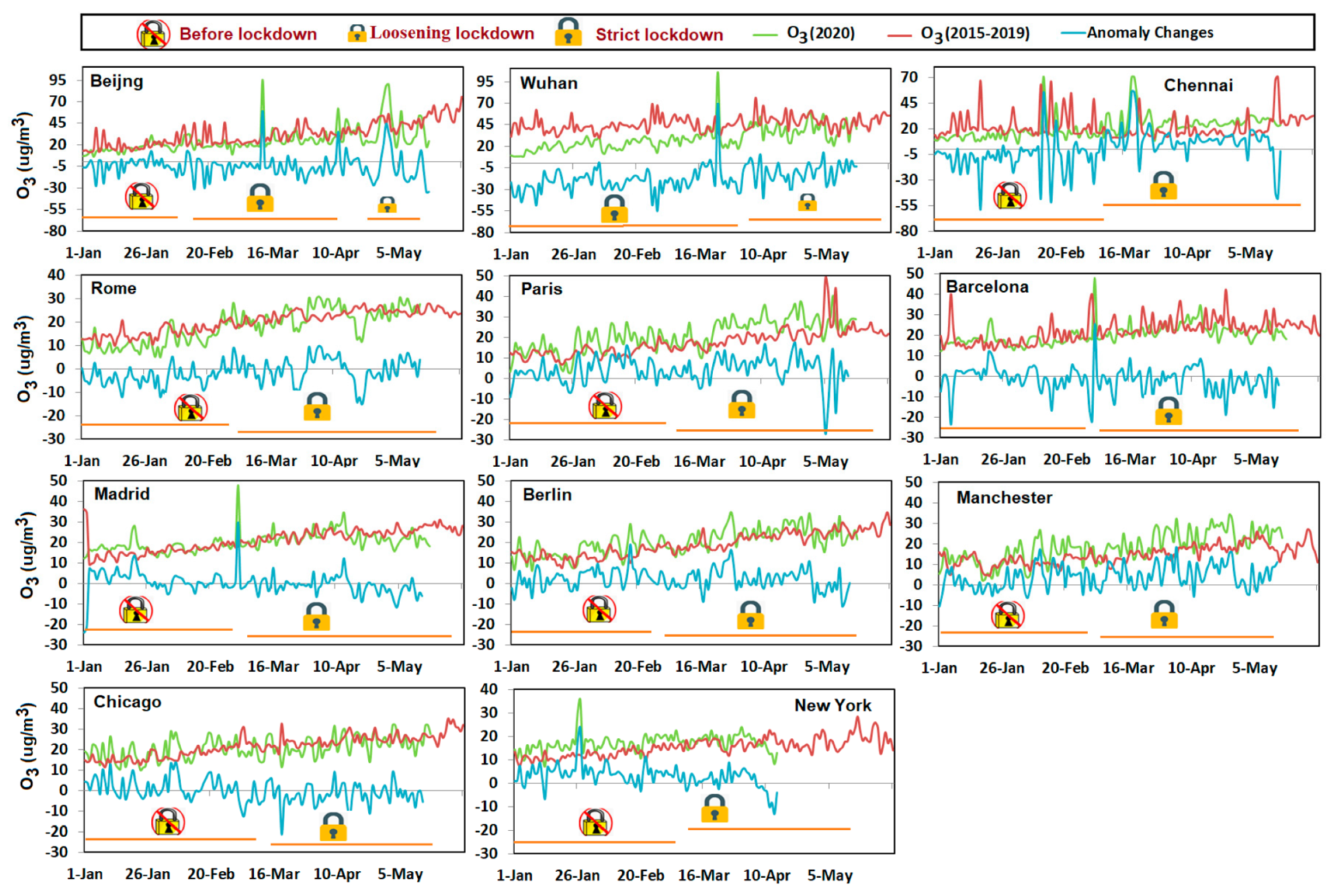
Figure 11 illustrates the daily mean dataset of tropospheric O3 concentration and its anomaly changes compared to the baseline from January to May of 2020 over different major cities. Higher concentration of O3 was observed in the Asian cities especially Beijing and Wuhan compared to cities in Europe and North America, which can be explained by the higher contribution of vehicle exhaust emission for O3 formation. O3 concentration was much lower than the baseline in Wuhan after the lockdown was imposed. However, for Chennai city in South Asia, the O3 concentration increased compared to previous years’ data after lockdown. The same phenomenon was also observed in European cities like Rome, Paris, and Manchester. In Barcelona and Madrid where slight decline occurred after the first week of April 2020. The increase of O3 in many European cities compared to Asian cities can be explained by their lower NOx emissions which might lead to a lower titration of O3 under the controlled transport emissions caused by the lockdown.
Table 3 lists the percentage change of NO2, CO, SO2, O3 and PM2.5 concentrations comparing the emission level of 2020 during lockdown period with the baseline (the same period in 2015–2019) over the 16 major cities selected. From this table, clear drops in air pollution caused by lockdown can be observed. Overall results indicate that concentrations of pollutants dropped over all of the studied cities during the lockdown period. The maximum reduction in NO2 was ~49% (London), CO was ~43% (Wuhan), PM2.5 was ~38% (Chennai) and SO2 was ~48% (Beijing). In the case of urban O3, the maximum reduction was ~43% in Wuhan, but a significant increase of ~47% was also observed in Chennai. Combined with the WHO COVID-19 case confirmed number data, we can observe a general trend that the more cases confirmed in a city, the stricter level of lockdown was enforced and the greater the improvement in air quality.

4. Discussions

The results from in situ ground-based observation agree well with the results from the satellite observation, which was not only confirmed in this study but also in other studies [61]. This provides a foundation for us to discuss the findings from different observation methods together. In our study, past multi-year data were used as the baseline to help reduce the effects of inter-annual climatic variability in air pollution [63].

4.1. Satellite Observation

We can see from the satellite observation results that the strict lockdown measures facilitated substantial reductions in NO2, SO2, and AOD. Strict lockdown measures imposed during the COVID-19 epidemic not only decreased the power generation and energy consumption but also lowered the oil demand, consequently posing positive implications on the ecosystem [94,95]. NO2 in 2020 remained at the same level as the baseline before lockdown but declined obviously after lockdown. Recent evidence from imageries published by the ESA (European Space Agency) and NASA also reported that NO2 emission during 2020 lockdown had dramatically dropped for about 30% over the Northeast US and 40–49% over Asian countries (mainly China, India, and Pakistan) compared to 2019 data during the same time period [58].
SO2 concentration of this year was overall higher than that of the past several years before lockdown, but declined unevenly over all regions after lockdown. Similar evidence was also provided by NASA [61] and ESA [44], which showed a strong decline in SO2 emissions, especially over South Asia and East Asia. Recent declines in air pollution across all global regions are associated with less consumption of fossil fuels [22,96], which ultimately reduced the level of pollutants in the atmosphere during the lockdown period [51,53,97].
The AOD maps indicated that the values were much higher in both Asia regions compared to Europe and North America, which might contribute to Europe and North America’s low response in AOD to lockdown. AOD level over East Asia (mainly China) exhibited significant drop during the first 7 weeks of 2020, which highlights a clear impact of reduced anthropogenic activities on the AOD level during both Chinese New Year and the pandemic lockdown period [61]. However, after the lockdown was gradually and partially lifted, the AOD level started to increase and approached to past years’ average values [98,99]. Similar behavior of AOD was also observed in South Asia. The majority of the aerosols formed in the Indo-Pak region are associated with anthropogenic emissions such as emissions from vehicles, coal-fired power plants, industrial sources, and burning agricultural farms [100]. During the pandemic lockdown, the restricted use of fossil fuels has decreased the emission sources of airborne particles in the atmosphere [51] and these changes can be proxies for the decline in AOD [31,101].
We used total column ozone data only for continent scale analysis and used ground-based observation data which is tropospheric ozone for city scale analysis. Ground-based observation data lack spatial representativeness and cannot be used to cover large areas such as continental scale, so a remote sensing approach is required when it comes to continental scale data analysis. However, separating between tropospheric ozone and stratosphere ozone to acquire only tropospheric ozone using reflectance spectra in remote sensing is difficult [94]. Because only total ozone column data can be acquired without substantial calculation for extracting tropospheric ozone, we chose to only use total column ozone from the OMI sensor for continental level ozone analysis. A large portion of the total ozone column consists of stratospheric ozone that is mostly naturally induced and is sensitive to clouds and weather phenomena. A smaller portion of the total column ozone consists of tropospheric ozone [102,103,104] and it is mainly generated from air pollution, which means that it is mainly affected by human activities. While using total column ozone alone to assess the impact of lockdown on tropospheric ozone may create bias since a bigger portion of ozone in the total column is not primarily affected by human activity, we did not mean to use it in direct quantitative analysis for the tropospheric ozone. We only used this data to assess the change in overall O3 condition globally and qualitatively to imply its influence on tropospheric ozone. By taking into consideration the inter-annual variability and seasonal changes of stratospheric ozone, we minimized the bias in qualitative analysis of the relationship between lockdown and tropospheric ozone level indicated from total column O3. Decline in total column O3 was observed over the North America region while only slight decline was observed in some locations over East Asia during the first 9 weeks of 2020. In general, our result indicated that O3 in 2020 decreased compared to the baseline. O3 levels from both the baseline and 2020 were higher in March and April, which exactly coincided with recent evidence provided by NASA scientists that the unusual weather in 2020 led to a low-level of ozone [44] and that stratospheric O3 is thicker in March and April. Studies conducted by [105,106] revealed a positive correlation between NO2 and stratosphere O3, which would partially explain the decrease of O3 in North America and Europe since those two regions had larger decline in NO2. SO2 is one of the ozone-depleting chemicals [107] and less decline in SO2 in North America and Europe will also lead to the decline of O3.

4.2. Ground-Based Observation

We used ground-based air quality data over metropolitan cities along with the satellite observed data for the following reasons: Firstly, satellite datasets used in this study do not reflect changes in pollutant concentration at city scale with finer details due to their 0.250×0.250 spatial resolution. Secondly, some pollutants like PM2.5 cannot be measured directly from space satellites. The changes in air pollution might also be induced by meteorological effects [105]; however, the air pollution over the city level are mainly prejudiced by anthropogenic emissions and chemical mechanisms [108,109]. Ground-based observations in this study revealed that strict lockdown measures caused substantial reduction in NO2, CO, PM2.5, and SO2 over the studied metropolitan cities.
Larger decline in NO2 was seen over the metropolitan cities in Europe, which can be explained by the reduced contribution of NO2 emission from transport sectors, the largest contributor to NO2 emission in European cities [91]. In East Asia (mainly China), NO2 emission dropped by ~39% (Beijing) and ~37% (Wuhan) and remained at a low level till April 2020, but the NO2 level started to recover to the level of baseline since April. Rise in NO2 can be explained by the partial lifting of lockdown and resuming of anthropogenic activities that contribute to primary NO2 emission, since the fossil fuel consumption and road traffic are the major sources of air pollution in these cities [92].
Metropolitan cities located in South and East Asia exhibited bigger reduction in PM2.5 compared to those from Europe and North America. Anthropogenic emissions (e.g., coal consumption, industrial harboring of iron, and smelting steel) are the major contributors (about 67%) to PM2.5 compared to the transport sector which only contributes 5% [92,110]. Mainly in East Asian cities (Beijing and Wuhan), the higher reduction in PM2.5 can be considered proxies to the controlled emissions from coal combustion and industrial activities during the lockdown [61]. The SO2 level declined significantly over all studied cities while maximum decline was observed over Wuhan (~48%) and Beijing (~49%). The main sources of SO2 emissions are power generation, smelter, and burning of fossil fuels. As explained in Figure 1b, the higher density of power plants and smelters in South and East Asia contributed to higher SO2 emissions, but reduced emissions from the source during lockdown lowered the SO2 level largely.
Ground-based city scale surface ozone data was used to accurately analyze the impact of lockdown on ozone pollution [111]. Tropospheric O3 increased primarily over Rome, Paris, Berlin, and Manchester; however, a visible drop remains to be seen over Barcelona, Beijing, and Wuhan. Because tropospheric O3 mainly forms from the chemical reaction between NOx and volatile organic compounds (VOCs) in the presence of ultraviolet radiations from sunlight, a lack of sunshine will result in the reduction of O3. In urban regions, formation of O3 mainly depends on the VOC-NOx ratio, which implies that reduction in VOC can decrease the O3 formation, while the reduction in NOx can increase the O3 formation over the Earth’s surface [112]. In cities, O3 is mainly depleted by the NOX emission from the transport sector [113]. Strict lockdown measures especially over the metropolitan cities have reduced the NOx emission which ultimately has increased the tropospheric O3 production [63,114]. Generally, the increase in O3 over the European cities can be explained by the decrease of road traffic emissions following the strict lockdown measures, because the overall contribution of road traffic emissions to O3 levels is about 12–35% over some European cities [115]. The varying pattern in the O3 level can be explained by different conditions in weather (sunshine), NOX emission, and VOC level. For example, even though the huge reduction in NOX around the globe would normally lead to the increase in surface O3 as exhibited in many cities, the production of O3 in cities like Wuhan is also largely restrained by VOC [63]. In addition, both the generally cloudy weather (http://tianqi.2345.com/wea_history/57494.htm) and the high AOD level in Wuhan during January–March 2020 contributed to the reduction of sunshine that is needed to form O3, thus partially leading to the reduced level of O3 in 2020 compared to the baseline. In general, our findings agree with those reported by some recent studies, the controlled human activities have reduced the anthropogenic emissions [116] and improved the air quality for 40–54% over the metropolitan and industrialized regions [51,53,117,118,119] due to strict quarantine measures [95].

5. Conclusions

This study attempted to compile the data from multiple missions (MODIS and OMI) along with ground-based air quality data to investigate the changes in air pollution in response to COVID-19 pandemic lockdown at continental and city scales. While satellite datasets used in this study cover the whole globe and have a relatively higher spatial resolution, they do not reflect changes in pollutant concentration at the city scale; therefore, we supplemented satellite data with ground-based in situ observed air quality data.
Results of satellite observations at the continental scale depict that concentrations of NO2, SO2, and AOD substantially dropped in 2020 during the lockdown period compared to their averages in the baseline period over all continents, where a maximum reduction of ~33% for NO2 was found in East Asia, ~41% for SO2 also in East Asia, and ~37% for AOD in South Asia. In the case of O3, a maximum reduction was observed as ~11% in Europe followed by ~10% in North America, while a slight increase was found in other study regions. These findings align with ground-based air quality data in this study, which showed that pollutants such as NO2, CO, PM2.5, and SO2 during the 2020 lockdown period decreased significantly except for O3 which increased over the South and East Asia regions. Specifically, a maximum reduction of ~49% for NO2 emission was found in London, ~43% for CO emission in Wuhan, ~38% for PM2.5 in Chennai, and ~48% for SO2 in Beijing. In the case of urban O3, a maximum reduction of ~43% was found in Wuhan, but a significant increase of ~47% was also observed in Chennai. It is generally observed that pollutants that are contributed more by industrial emissions have a larger decline after lockdown.
By combining different scales of data, we analyzed and discussed the effect of lockdown measures on air pollutants and air quality at different scales. This study revealed an overall decline in pollutants around the globe during lockdown time and had some interesting findings, which are in agreement with other regional studies. To fully explore the long-term effect of COVID-19, more follow-up studies using a longer period of pollutant data will be required. We hope this paper can inspire further studies on the topic of COVID-19, one of the largest global pandemics that, for the first time in history, paused human activity for such a long time.

Author Contributions

Conceptualization, C.Z., Z.Z., and A.A.; methodology, Z.Z. and A.A.; software, Z.Z., A.A. and S.H.; validation, Z.Z.; formal analysis, Z.Z. and A.A.; investigation, Z.Z.; resources, C.Z. and W.L.; data curation, S.H.; writing—original draft preparation, Z.Z., C.Z., W.L. and A.A.; writing—review and editing, Z.Z. and W.L.; visualization, A.A.; supervision, C.Z.; project administration, C.Z.; funding acquisition, C.Z. All authors have read and agreed to the published version of the manuscript.

Funding

This research received no external funding.

Acknowledgments

We are grateful to NASA for its great efforts to make remote sensing data available to the public. Zhijie Zhang is very grateful to both Connecticut Safety Research Center for providing GA-ship that supports his Ph.D. study and Zhe Zhu for his mentoring and the Remote Sensing Class he designed. Arshad is very grateful to CAS-TWAS President’s Fellowship Program for providing financial support for his Ph.D. study as well as the equipment involved in this study.

Conflicts of Interest

The authors declare no conflict of interest.

References

  1. Worldometer. Worldometers.Info/World-Population. Available online: https://www.worldometers.info/world-population/ (accessed on 2 June 2020).
  2. Subramaniam, Y.; Masron, T.A.; Azman, N.H.N. Biofuels, environmental sustainability, and food security: A review of 51 countries. Energy Res. Soc. Sci. 2020, 68, 101549. [Google Scholar] [CrossRef]
  3. Weis, T. Food security and food sovereignty. In International Encyclopedia of Human Geography, 2nd ed.; Kobayashi, A., Ed.; Elsevier: Oxford, UK, 2020; pp. 191–196. [Google Scholar]
  4. Helin, J.; Weikard, H.-P. A model for estimating phosphorus requirements of world food production. Agric. Syst. 2019, 176, 102666. [Google Scholar] [CrossRef]
  5. Fukase, E.; Martin, W. Economic growth, convergence, and world food demand and supply. World Dev. 2020, 132, 104954. [Google Scholar] [CrossRef]
  6. Iqbal, M.M.; Shoaib, M.; Agwanda, P.; Lee, J.L. Modeling approach for water-quality management to control pollution concentration: A case study of Ravi River, Punjab, Pakistan. Water 2018, 10, 1068. [Google Scholar] [CrossRef] [Green Version]
  7. Iqbal, M.M.; Shoaib, M.; Agwanda, P.O. The Response of Pollution Load from Coastal River Waterfront on Red Tides in South Sea. J. Coast. Res. 2019, 91, 231–235. [Google Scholar] [CrossRef]
  8. Nations, U. World Urbanization Prospects 2018-Highlights; Department of Economic and Social Affairs, Population Division: New York, NY, USA, 2019. [Google Scholar]
  9. Kim, K.-H.; Kabir, E.; Kabir, S. A review on the human health impact of airborne particulate matter. Environ. Int. 2015, 74, 136–143. [Google Scholar] [CrossRef]
  10. Lelieveld, J.; Evans, J.S.; Fnais, M.; Giannadaki, D.; Pozzer, A. The contribution of outdoor air pollution sources to premature mortality on a global scale. Nature 2015, 525, 367–371. [Google Scholar] [CrossRef]
  11. Anenberg, S.; Miller, J.; Henze, D.; Minjares, R. A Global Snapshot of the Air Pollution-Related Health Impacts of Transportation Sector Emissions in 2010 and 2015; International Council on Clean Transportation: Washington, DC, USA, 2019. [Google Scholar]
  12. Gu, Y.; Zhang, W.; Yang, Y.; Wang, C.; Streets, D.G.; Yim, S.H.L. Assessing outdoor air quality and public health impact attributable to residential black carbon emissions in rural China. Resour. Conserv. Recycl. 2015, 159, 104812. [Google Scholar] [CrossRef]
  13. Chen, X.; Li, F.; Zhang, J.; Zhou, W.; Wang, X.; Fu, H. Spatiotemporal mapping and multiple driving forces identifying of PM2.5 variation and its joint management strategies across China. J. Clean. Prod. 2020, 250, 119534. [Google Scholar] [CrossRef]
  14. Ramanathan, V.; Feng, Y. Air pollution, greenhouse gases and climate change: Global and regional perspectives. Atmos. Environ. 2009, 43, 37–50. [Google Scholar] [CrossRef]
  15. Shakun, J.D.; Clark, P.U.; He, F.; Marcott, S.A.; Mix, A.C.; Liu, Z.; Otto-Bliesner, B.; Schmittner, A.; Bard, E. Global warming preceded by increasing carbon dioxide concentrations during the last deglaciation. Nature 2012, 484, 49–54. [Google Scholar] [CrossRef] [PubMed]
  16. Maji, K.J. Substantial changes in PM2 5 pollution and corresponding premature deaths across China during 2015–2019: A model prospective. Sci. Total Environ. 2020, 279, 138838. [Google Scholar] [CrossRef] [PubMed]
  17. Conticini, E.; Frediani, B.; Caro, D. Can atmospheric pollution be considered a co-factor in extremely high level of SARS-CoV-2 lethality in Northern Italy? Environ. Pollut. 2020, 261, 114465. [Google Scholar] [CrossRef] [PubMed]
  18. Yousefian, F.; Nadafi, K. An Appropriate Theoretical Model. for Developing Ambient Air Quality Standard in Iran. Based on Standard Setting Approaches of Different Parts of the World. J. Health 2019, 10, 411–426. [Google Scholar] [CrossRef]
  19. Beig, G.; Sahu, S.K.; Singh, V.; Tikle, S.; Sobhana, S.B.; Gargeva, P.; Ramakrishna, K.; Rathod, A.; Murthy, B.S. Objective evaluation of stubble emission of North. India and quantifying its impact on air quality of Delhi. Sci. Total Environ. 2020, 709, 136126. [Google Scholar] [CrossRef]
  20. Gao, M.; Gao, J.; Zhu, B.; Kumar, R.; Lu, X.; Song, S.; Zhang, Y.; Jia, B.; Wang, P.; Beig, G.; et al. Ozone pollution over China and India: Seasonality and sources. Atmos. Chem. Phys. 2020, 20, 4399–4414. [Google Scholar] [CrossRef] [Green Version]
  21. Mathur, B.H. High resolution air pollution mapping using wireless sensor nodes. In Proceedings of the 2020 6th International Conference on Advanced Computing and Communication Systems (ICACCS), Coimbatore, India, 6–7 March 2020. [Google Scholar]
  22. Wang, Z.; Wei, W.; Zheng, F. Effects of industrial air pollution on the technical efficiency of agricultural production: Evidence from China. Environ. Impact Assess. Rev. 2020, 83, 106407. [Google Scholar] [CrossRef]
  23. Reinardt, F.; Seifert, H.; Gehrmann, H.-J. Use of Low-quality Biogenic Fuels in a Decentralized Biomass Boiler for Thermal Energy Generation. Energy Procedia 2017, 120, 286–293. [Google Scholar] [CrossRef]
  24. Han, S.; Kim, J.; Bae, C. Effect of air–fuel mixing quality on characteristics of conventional and low temperature diesel combustion. Appl. Energy 2014, 119, 454–466. [Google Scholar] [CrossRef]
  25. Zhang, Y.; Zhu, j.; Lyu, Q.; Liu, J.; Pan, F.; Zhang, J. The ultra-low NOx emission characteristics of pulverized coal combustion after high temperature preheating. Fuel 2020, 277, 118050. [Google Scholar] [CrossRef]
  26. Jiang, L.; He, S.; Cui, Y.; Zhou, H.; Kong, H. Effects of the socio-economic influencing factors on SO2 pollution in Chinese cities: A spatial econometric analysis based on satellite observed data. J. Environ. Manag. 2020, 268, 110667. [Google Scholar] [CrossRef] [PubMed]
  27. Cohen, A.J.; Brauer, M.; Burnett, R.; Anderson, H.R.; Frostad, J.; Estep, K.; Balakrishnan, K.; Brunekreef, B.; Dandona, L.; Dandona, R.; et al. Estimates and 25-year trends of the global burden of disease attributable to ambient air pollution: An analysis of data from the Global Burden of Diseases Study 2015. Lancet 2017, 389, 1907–1918. [Google Scholar] [CrossRef] [Green Version]
  28. Nuvolone, D.; Petri, D.; Voller, F. The effects of ozone on human health. Environ. Sci. Pollut. Res. 2018, 25, 8074–8088. [Google Scholar] [CrossRef] [PubMed]
  29. Qu, Z.; Henze, D.K.; Li, C.; Theys, N.; Wang, Y.; Wang, J.; Wang, W.; Han, J.; Shim, C.; Dickerson, R.R. SO2 emission estimates using OMI SO2 retrievals for 2005–2017. J. Geophys. Res. Atmos. 2019, 124, 8336–8359. [Google Scholar] [CrossRef] [PubMed] [Green Version]
  30. Šerbula, M.S.; Ţivkovic, T.D.; Radojević, A.A.; Kalinovic, S.; Kalinovic, V.J. Emission of SO2 and SO42− from copper smelter and its influence on the level of total s in soil and moss in Bor and the surroundings. Hem. Ind. 2015, 69, 51–58. [Google Scholar] [CrossRef]
  31. Seinfeld, J.H.; Pandis, S.N. Atmospheric Chemistry and Physics: From Air Pollution to Climate Change; John Wiley & Sons: Hoboken, NJ, USA, 2016. [Google Scholar]
  32. Zhang, Q.; Jimenez, J.L.; Canagaratna, M.R.; Allan, J.D.; Coe, H.; Ulbrich, I.; Alfarra, M.R.; Takami, A.; Middlebrook, A.M.; Sun, Y.L. Ubiquity and dominance of oxygenated species in organic aerosols in anthropogenically-influenced Northern Hemisphere midlatitudes. Geophys. Res. Lett. 2007, 34. [Google Scholar] [CrossRef] [Green Version]
  33. Cheng, M.; Jiang, H.; Guo, Z. Evaluation of long-term tropospheric NO2 columns and the effect of different ecosystem in Yangtze River Delta. Procedia Environ. Sci. 2012, 13, 1045–1056. [Google Scholar] [CrossRef] [Green Version]
  34. Federico, K.; van Dingenen, R.; Claudio, B.; Greet, G.-M.; Monica, C.; Diego, G.; Franciscus, D. Attribution of Anthropogenic PM2.5 to Emission Sources; JRC Technical Reports; EUR 28510 EN; Publications Office of the European Union: Brussels, Belgium, 2017.
  35. Atkinson, R.W.; Butland, B.K.; Anderson, H.R.; Maynard, R.L. Long-term concentrations of nitrogen dioxide and mortality: A meta-analysis of cohort studies. Epidemiology 2018, 29, 460–472. [Google Scholar] [CrossRef]
  36. Rana, W.; Mukhtar, S.; Mukhtar, S. Mental health of medical workers in Pakistan during the pandemic COVID-19 outbreak. Asian J. Psychiatry 2020, 51, 102080. [Google Scholar] [CrossRef]
  37. Ferretti, L.; Wymant, C.; Kendall, M.; Zhao, L.; Nurtay, A.; Abeler-Dörner, L.; Parker, M.; Bonsall, D.; Fraser, C. Quantifying SARS-CoV-2 transmission suggests epidemic control with digital contact tracing. Science 2020, 368, eabb6936. [Google Scholar] [CrossRef] [Green Version]
  38. Mittal, R.; Ni, R.; Seo, J.-H. The flow physics of COVID-19. J. Fluid Mech. 2020, 894. [Google Scholar] [CrossRef]
  39. World Health Organization. Getting Your Workplace Ready for COVID-19: How COVID-19 Spreads; World Health Organization: Geneva, Switzerland, 2020. [Google Scholar]
  40. Givi, B.; Schiff, B.A.; Chinn, S.B.; Clayburgh, D.; Iyer, N.G.; Jalisi, S.; Moore, M.G.; Nathan, C.A.; Orloff, L.A.; O’Neill, J.P.; et al. Safety recommendations for evaluation and surgery of the head and neck during the COVID-19 pandemic. JAMA Otolaryngol. Head Neck Surg. 2020, 146, 579–584. [Google Scholar] [CrossRef] [Green Version]
  41. Sohrabi, C.; Alsafi, Z.; O’Neill, N.; Khan, M.; Kerwan, A.; Al-Jabir, A.; Iosifidis, C.; Agha, R. World Health Organization declares global emergency: A review of the 2019 novel coronavirus (COVID-19). Int. J. Surg. 2020, 76, 71–76. [Google Scholar] [CrossRef] [PubMed]
  42. World Health Organization. Coronavirus Disease 2019 (COVID-19): Situation Report, 92; World Health Organization: Geneva, Switzerland, 2020. [Google Scholar]
  43. Tosepu, R.; Gunawan, J.; Effendy, D.S.; Ahmad, L.O.A.I.; Lestari, H.; Bahar, H.; Asfian, P. Correlation between weather and Covid-19 pandemic in Jakarta, Indonesia. Sci. Total Environ. 2020, 725, 138436. [Google Scholar] [CrossRef] [PubMed]
  44. NASA, National Aeronautics and Space Administration. Available online: https://www.nasa.gov/feature/goddard/2020/nasa-reports-arctic-stratospheric-ozone-depletion-hit-record-low-in-march (accessed on 30 May 2020).
  45. Alvarez, F.E.; Argente, D.; Lippi, F. A simple planning problem for covid-19 lockdown. Natl. Bur. Econ. Res. 2020. [Google Scholar] [CrossRef]
  46. Lau, H.; Khosrawipour, V.; Kocbach, P.; Mikolajczyk, A.; Schubert, J.; Bania, J.; Khosrawipour, T. The positive impact of lockdown in Wuhan on containing the COVID-19 outbreak in China. J. Travel Med. 2020, 27, taaa037. [Google Scholar] [CrossRef] [Green Version]
  47. Willan, J.; King, A.J.; Djebbari, F.; Turner, G.D.H.; Royston, D.J.; Pavord, S.; Collins, G.P.; Peniket, A. Assessing the Impact of Lockdown: Fresh Challenges for the Care of Haematology Patients in the COVID-19 Pandemic. Br. J. Haematol. 2020, 189, e224–e227. [Google Scholar] [CrossRef] [PubMed]
  48. Pulla, P. Covid-19: India imposes lockdown for 21 days and cases rise. Br. Med J. Publ. Group 2020, 368, m1251. [Google Scholar] [CrossRef] [Green Version]
  49. McKibbin, W.J.; Fernando, R. The Global Macroeconomic Impacts of COVID-19: Seven Scenarios; CAMA Work. Paper, No. 19/2020; Brookings Institute: Washington, DC, USA, 2020. [Google Scholar] [CrossRef] [Green Version]
  50. May, B. World Economic Prospects Monthly (2/2020) Economic Outlook. Oxf. Econ. 2020, 44, 1–33. [Google Scholar] [CrossRef]
  51. Mahato, S.; Pal, S.; Ghosh, K.G. Effect of lockdown amid COVID-19 pandemic on air quality of the megacity Delhi, India. Sci. Total Environ. 2020, 730, 139086. [Google Scholar] [CrossRef]
  52. Sharma, S.; Zhang, M.; Anshika; Gao, J.; Zhang, H.; Kota, S.H. Effect of restricted emissions during COVID-19 on air quality in India. Sci. Total Environ. 2020, 728, 138878. [Google Scholar] [CrossRef] [PubMed]
  53. Isaifan, R. The dramatic impact of Coronavirus outbreak on air quality: Has it saved as much as it has killed so far? Glob. J. Environ. Sci. Manag. 2020, 6, 275–288. [Google Scholar]
  54. Zhang, Y.; Gautam, R.; Zavala-Araiza, D.; Jacob, D.J.; Zhang, R.; Zhu, L.; Sheng, J.-X.; Scarpelli, T. Satellite-Observed Changes in Mexico’s Offshore Gas. Flaring Activity Linked to Oil/Gas. Regulations. Geophys. Res. Lett. 2019, 46, 1879–1888. [Google Scholar] [CrossRef] [Green Version]
  55. Li, R.; Mei, X.; Chen, L.; Wang, L.; Wang, Z.; Jing, Y. Long-Term (2005–2017) View of Atmospheric Pollutants in Central China Using Multiple Satellite Observations. Remote Sens. 2020, 12, 1041. [Google Scholar] [CrossRef] [Green Version]
  56. Krotkov, N.A.; McLinden, C.A.; Li, C.; Lamsal, L.N.; Celarier, E.A.; Marchenko, S.V.; Swartz, W.H.; Bucsela, E.J.; Joiner, J.; Duncan, B.N.; et al. Aura OMI observations of regional SO2 and NO2 pollution changes from 2005 to 2014. Atmos. Chem. Phys. Discuss. 2015, 16, 4605–4629. [Google Scholar] [CrossRef] [Green Version]
  57. Kaufman, Y.J.; Tanré, D.; Remer, L.; Vermote, E.F.; Chu, A.W.-H.; Holben, B.N. Operational remote sensing of tropospheric aerosol over land from EOS moderate resolution imaging spectroradiometer. J. Geophys. Res. Atmos. 1997, 102, 17051–17067. [Google Scholar] [CrossRef]
  58. ESA, European Space Agency. Available online: https://www.esa.int/Applications/Observing_the_Earth/Copernicus/Sentinel-5P (accessed on 4 June 2020).
  59. Muhammad, S.; Long, X.; Salman, M. COVID-19 pandemic and environmental pollution: A blessing in disguise? Sci. Total Environ. 2020, 728, 138820. [Google Scholar] [CrossRef]
  60. Bauwens, M.; Compernolle, S.; Stavrakou, T.; Müller, J.; van Gent, J.; Eskes, H.; Levelt, P.F.; Veefkind, J.P.; Vlietinck, J.; Yu, H.; et al. Impact of coronavirus outbreak on NO2 pollution assessed using TROPOMI and OMI observations. Geophys. Res. Lett. 2020, 47, e2020GL087978. [Google Scholar] [CrossRef]
  61. Fan, C.; Li, Y.; Guang, J.; Li, Z.; Elnashar, A.; Allam, M.; de Leeuw, G. The Impact of the Control. Measures during the COVID-19 Outbreak on Air Pollution in China. Remote Sens. 2020, 12, 1613. [Google Scholar] [CrossRef]
  62. Gil, M.; Yela, M.; Gunn, L.N.; Richter, A.; Alonso, I.; Chipperfield, M.P.; Cuevas, E.; Iglesias, J.; Navarro, M.; Puentedura, O.; et al. NO2 climatology in the northern subtropical region: Diurnal, seasonal and interannual variability. Atmos. Chem. Phys. 2008, 8, 1635–1648. [Google Scholar] [CrossRef] [Green Version]
  63. Sicard, P.; De Marco, A.; Agathokleous, E.; Feng, Z.; Xu, X.; Paoletti, E.; Rodriguez, J.J.D.; Calatayud, V. Amplified ozone pollution in cities during the COVID-19 lockdown. Sci. Total Environ. 2020, 735, 139542. [Google Scholar] [CrossRef] [PubMed]
  64. Levelt, P.F.; van den Oord, G.H.J.; Dobber, M.R.; Malkki, A.; Visser, H.; de Vries, J.; Stammes, P.; Lundell, J.O.V.; Saari, H. The Ozone Monitoring Instrument; IEEE Transactions on Geoscience and Remote Sensing: Piscataway, NJ, USA, 2006. [Google Scholar]
  65. Fioletov, V.E.; McLinden, C.A.; Krotkov, N.; Moran, M.D.; Yang, K. Estimation of SO2 emissions using OMI retrievals. Geophys. Res. Lett. 2011, 38. [Google Scholar] [CrossRef]
  66. Lee, C.; Martin, R.V.; van Donkelaar, A.; Lee, H.; Dickerson, R.R.; Hains, J.C.; Krotkov, N.; Richter, A.; Vinnikov, K.; Schwab, J.J. SO2 emissions and lifetimes: Estimates from inverse modeling using in situ and global, space-based (SCIAMACHY and OMI) observations. J. Geophys. Res. Atmos. 2011, 116. [Google Scholar] [CrossRef] [Green Version]
  67. Li, C.; Joiner, J.; Krotkov, N.A.; Bhartia, P.K. A fast and sensitive new satellite SO2 retrieval algorithm based on principal component analysis: Application to the ozone monitoring instrument. Geophys. Res. Lett. 2013, 40, 6314–6318. [Google Scholar] [CrossRef] [Green Version]
  68. Eskes, H.; Boersma, K. Averaging kernels for DOAS total-column satellite retrievals. Atmos. Chem. Phys. 2003, 3, 1285–1291. [Google Scholar] [CrossRef] [Green Version]
  69. Kroon, M.; Veefkind, J.P.; Sneep, M.; McPeters, R.D.; Bhartia, P.K.; Levelt, P.F. Comparing OMI-TOMS and OMI-DOAS total ozone column data. J. Geophys. Res. Atmos. 2008, 113. [Google Scholar] [CrossRef] [Green Version]
  70. Levelt, P.F.; Joiner, J.; Tamminen, J.; Veefkind, J.P.; Bhartia, P.K.; Carn, S. The Ozone Monitoring Instrument: Overview of 14 years in space. Atmos. Chem. Phys. 2018, 18, 5699. [Google Scholar] [CrossRef] [Green Version]
  71. Van Geffen, J.; Boersmaet, K.F.; Eskes, H.; Sneep, M.; ter Linden, M.; Zara, M.; Veefkind, J.P. S5P TROPOMI NO2 slant column retrieval: Method, stability, uncertainties and comparisons with OMI. Atmos. Meas. Tech. 2020, 13, 1315–1335. [Google Scholar] [CrossRef] [Green Version]
  72. Balis, D.S.; Kroon, M.; Koukouli, M.; Brinksma, E.J.; Labow, G.J.; Veefkind, J.P.; Mcpeters, R.D. Validation of Ozone Monitoring Instrument total ozone column measurements using Brewer and Dobson spectrophotometer ground-based observations. J. Geophys. Res. Atmos. 2007, 112. [Google Scholar] [CrossRef] [Green Version]
  73. Buchard, V.; Brogniez, C.; Auriol, F.; Bonnel, B.; Lenoble, J.; Tanskanen, A.; Bojkov, B.; Veefkind, P. Comparison of OMI ozone and UV irradiance data with ground-based measurements at two French sites. Atmos. Chem. Phys. 2008, 8, 4517–4528. [Google Scholar] [CrossRef] [Green Version]
  74. Oluleye, A.; Okogbue, E.C. Analysis of temporal and spatial variability of total column ozone over West. Africa using daily TOMS measurements. Atmos. Pollut. Res. 2013, 4, 387–397. [Google Scholar] [CrossRef] [Green Version]
  75. Boersma, K.F.; Jacob, D.J.; Bucsela, E.J.; Perring, A.E.; Dirksen, R.; van der A, R.J.; Yantosca, R.M.; Park, R.J.; Wenig, M.O.; Bertram, T.H.; et al. Validation of OMI tropospheric NO2 observations during INTEX-B and application to constrain NOx emissions over the eastern United States and Mexico. Atmos. Environ. 2008, 42, 4480–4497. [Google Scholar] [CrossRef] [Green Version]
  76. Yan, H.-H.; Li, X.-J.; Zhang, X.-Y.; Wang, W.-H.; Chen, L.-F.; Zhang, M.-G.; Xu, J. Comparison and validation of band residual difference algorithm and principal component analysis algorithm for retrievals of atmospheric SO2 columns from satellite observations. Acta Phys. Sinica. 2016, 65, 084204. [Google Scholar]
  77. Fu, D.; Worden, J.R.; Liu, X.; Kulawik, S.S.; Bowman, K.W.; Natraj, V. Characterization of ozone profiles derived from Aura TES and OMI Radiances. Atmos. Chem. Phys. Discuss. 2013, 13, 3445–3462. [Google Scholar] [CrossRef] [Green Version]
  78. Paschou, P.; Koukouli, M.-E.; Balis, D.; Lerot, C.; Van Roozendael, M. The effect of considering polar vortex dynamics in the validation of satellite total ozone observations. Atmos. Res. 2020, 238, 104870. [Google Scholar] [CrossRef]
  79. Hulswar, S.; Soni, V.K.; Sapate, J.P.; More, R.S.; Mahajan, A.S. Validation of satellite retrieved ozone profiles using in-situ ozonesonde observations over the Indian Antarctic station, Bharati. Polar Sci. 2020, 100547. [Google Scholar] [CrossRef]
  80. Hsu, N.C.; Jeong, M.-J.; Bettenhausen, C.; Sayer, A.M.; Hansell, R.; Seftor, C.S.; Huang, J.; Tsay, S.-C. Enhanced Deep Blue aerosol retrieval algorithm: The second generation. J. Geophys. Res. Atmos. 2013, 118, 9296–9315. [Google Scholar] [CrossRef]
  81. Hsu, N.C.; Lee, J.; Sayer, A.M.; Kim, W.; Bettenhausen, C.; Tsay, S.-C. VIIRS Deep Blue aerosol products over land: Extending the EOS long-term aerosol data records. J. Geophys. Res. Atmos. 2019, 124, 4026–4053. [Google Scholar] [CrossRef]
  82. Levy, R.C.; Remer, L.A.; Mattoo, S.; Vermote, E.F.; Kaufman, Y.J. Second-generation operational algorithm: Retrieval of aerosol properties over land from inversion of Moderate Resolution Imaging Spectroradiometer spectral reflectance. J. Geophys. Res. Atmos. 2007, 112. [Google Scholar] [CrossRef] [Green Version]
  83. Sayer, A.M.; Hsu, N.C.; Lee, J.; Kim, W.V.; Dutcher, S.T. Validation, stability, and consistency of MODIS Collection 6.1 and VIIRS Version 1 Deep Blue aerosol data over land. J. Geophys. Res. Atmos. 2019, 124, 4658–4688. [Google Scholar] [CrossRef]
  84. Tian, X.; Liu, Q.; Li, X.; Wei, J. Validation and comparison of MODIS C6. 1 and C6 aerosol products over Beijing, China. Remote Sens. 2018, 10, 2021. [Google Scholar] [CrossRef] [Green Version]
  85. Wang, Y.; Yuan, Q.; Li, T.; Shen, H.; Zheng, L.; Zhang, L. Evaluation and comparison of MODIS Collection 6.1 aerosol optical depth against AERONET over regions in China with multifarious underlying surfaces. Atmos. Environ. 2019, 200, 280–301. [Google Scholar] [CrossRef] [Green Version]
  86. Sayer, A.M.; Hsu, N.C.; Bettenhausen, C.; Jeong, M.-J. Validation and uncertainty estimates for MODIS Collection 6 “Deep Blue” aerosol data. J. Geophys. Res. Atmos. 2013, 118, 7864–7872. [Google Scholar] [CrossRef] [Green Version]
  87. Levy, R.C.; Mattoo, S.; Munchak, L.A.; Remer, L.A.; Sayer, A.M.; Patadia, F.; Hsu, N.C. The Collection 6 MODIS aerosol products over land and ocean. Atmos. Meas. Tech. 2013, 6, 2989. [Google Scholar] [CrossRef] [Green Version]
  88. Sayer, A.M.; Munchak, L.A.; Hsu, N.C.; Levy, R.C.; Bettenhausen, C.; Jeong, M.-J. MODIS Collection 6 aerosol products: Comparison between Aqua’s e-Deep Blue, Dark Target., and “merged” data sets, and usage recommendations. J. Geophys. Res. Atmos. 2014, 119, 965–989. [Google Scholar] [CrossRef]
  89. Tao, M.; Chen, L.; Wang, Z.; Tao, Z.; Che, H.; Wang, X.; Wang, Y. Comparison and evaluation of the MODIS Collection 6 aerosol data in China. J. Geophys. Res. Atmos. 2015, 120, 6992–7005. [Google Scholar] [CrossRef]
  90. WHO. Available online: https://covid19.who.int/ (accessed on 29 May 2020).
  91. Gottlicher, S.; Micheal, G.; Nicole, M.; Katarina, M. European Union Emission Inventory Report 1990–2008 under the UNECE Convention on Long-range Transboundary Air Pollution (LRTAP); European Environment Agency: Copenhagen, Denmark, 2010.
  92. Wang, S.; Yu, S.; Yan, R.; Zhang, Q.; Li, P.; Wang, L.; Liu, W.; Zheng, X. Characteristics and origins of air pollutants in Wuhan, China, based on observations and hybrid receptor models. J. Air Waste Manag. Assoc. 2017, 67, 739–753. [Google Scholar] [CrossRef] [Green Version]
  93. Yienger, J.; Levy, H. Empirical model of global soil-biogenic NOχ emissions. J. Geophys. Res. Atmos. 1995, 100, 11447–11464. [Google Scholar] [CrossRef]
  94. Hasekamp, O.P.; Landgraf, J. Tropospheric ozone information from satellite-based polarization measurements. J. Geophys. Res. Atmos. 2002, 107, ACH 3-1–ACH 3-13. [Google Scholar] [CrossRef] [Green Version]
  95. Unprecedented Reduction in Airborne Aerosol Particles and Nitrogen Dioxide Level in Response to COVID-19 Pandemic Lockdown Over the Indo-Pak Region. Available online: https://www.essoar.org/pdfjs/10.1002/essoar.10503543.1 (accessed on 15 June 2020).
  96. Sharma, R.K.; Thanu, T.C.; Elampari, K. Surface Ozone Measurements in Southernmost Tip of Peninsular India. Univers. J. Environ. Res. Technol. 2013, 3, 255–265. [Google Scholar]
  97. Zhang, R.; Zhang, Y.; Lin, H.; Feng, X.; Fu, T.-M.; Wang, Y. NOx Emission Reduction and Recovery during COVID-19 in East. China. Atmosphere 2020, 11, 433. [Google Scholar] [CrossRef] [Green Version]
  98. Lal, P.; Kumar, A.; Kumar, S.; Kumari, S.; Saikia, P.; Dayanandan, A.; Adhikari, D.; Khan, M.L. The dark cloud with a silver lining: Assessing the impact of the SARS COVID-19 pandemic on the global environment. Sci. Total Environ. 2020, 732, 139297. [Google Scholar] [CrossRef] [PubMed]
  99. Timmermann, A.; Lee, S.; Chu, J.; Chung, E.; Lee, J. COVID-19-related drop in anthropogenic aerosol emissions in China and corresponding cloud and climate effects. Eartharxiv 2020. eartharxic.org/z5dm8. [Google Scholar]
  100. Guo, H.; Kota, S.H.; Sahu, S.K.; Hu, J.; Ying, Q.; Gao, A.; Zhang, H. Source apportionment of PM2.5 in North. India using source-oriented air quality models. Environ. Pollut. 2017, 231, 426–436. [Google Scholar] [CrossRef]
  101. Tariq, S.; Ali, M. Spatiotemporal patterns of correlation between atmospheric nitrogen dioxide and aerosols over South. Asia. Meteorol. Atmos. Phys. 2017, 129, 507–527. [Google Scholar]
  102. Remer, L.A.; Kaufman, Y.J.; Tanré, D.; Mattoo, S.; Chu, D.A.; Martins, J.V.; Li, R.-R.; Ichoku, C.; Levy, R.C.; Kleidman, R.G.; et al. The MODIS aerosol algorithm, products, and validation. J. Atmos. Sci. 2005, 62, 947–973. [Google Scholar] [CrossRef] [Green Version]
  103. Levelt, P.F.; Hilsenrath, E.; Leppelmeier, G.W.; van den Oord, G.H.J.; Bhartia, P.K.; Tamminen, J.; de Haan, J.F.; Veefkind, J.P. Science objectives of the ozone monitoring instrument. IEEE Trans. Geosci. Remote Sens. 2006, 44, 1199–1208. [Google Scholar] [CrossRef]
  104. UCAR. Center For Science Education. Available online: https://scied.ucar.edu/learn/about-ozone (accessed on 12 July 2020).
  105. Venkitaswamy, S.; Bhaskar, V. Relationship between ozone with nitrogen dioxide and climatic impacts over major cities in India. Sustain. Environ. Res. 2015, 25, 295–304. [Google Scholar]
  106. Safieddine, S.; Clerbaux, C.; George, M.; Hadji-Lazaro, J.; Hurtmans, D.; Coheur, P.-F.; Wespes, C.; Loyola, D.; Valks, P.; Hao, N. Tropospheric ozone and nitrogen dioxide measurements in urban and rural regions as seen by IASI and GOME-2. J. Geophys. Res. Atmos. 2013, 118, 555–566. [Google Scholar] [CrossRef] [Green Version]
  107. Klobas, J.E.; Wilmouth, D.M.; Weisenstein, D.K.; Anderson, J.G.; Salawitch, R.J. Ozone depletion following future volcanic eruptions. Geophys. Res. Lett. 2017, 44, 7490–7499. [Google Scholar] [CrossRef]
  108. Huszar, P.; Belda, M.; Halenka, T. On the long term impact of emissions from central European cities on regional air-quality. Atmos. Chem. Phys. Discuss. 2015, 15, 1331–1352. [Google Scholar] [CrossRef]
  109. Monks, P.S. Tropospheric ozone and its precursors from the urban to the global scale from air quality to short-lived climate forcer. Atmos. Chem. Phys. Discuss. 2015, 15, 8889–8973. [Google Scholar] [CrossRef] [Green Version]
  110. Qian, Z.; He, Q.; Lin, H.-M.; Kong, L.; Liao, D.; Dan, J.; Bentley, C.M.; Wang, B. Association of daily cause-specific mortality with ambient particle air pollution in Wuhan, China. Environ. Res. 2007, 105, 380–389. [Google Scholar] [CrossRef]
  111. Shi, X.; Brasseur, G.P. The Response in Air Quality to the Reduction of Chinese Economic Activities during the COVID-19 Outbreak. Geophys. Res. Lett. 2020, e2020GL088070. [Google Scholar] [CrossRef]
  112. Pusede, S.; Cohen, R. On the observed response of ozone to NOx and VOC reactivity reductions in San Joaquin Valley California 1995-present. Atmos. Chem. Phys. Discuss. 2012, 12, 8323–8339. [Google Scholar] [CrossRef] [Green Version]
  113. Molina, L.T.; de Foy, B.; Martínez, O.V.; Paramo Figueroa, V.H. Air quality, weather and climate in Mexico City. WMO Bull. 2009, 58, 48. [Google Scholar]
  114. Sicard, P.; Augustaitis, A.; Belyazid, S.; Calfapietra, C.; Marco, A.; Fenn, M.; Bytnerowicz, A.; Grulke, N.; He, S. Global topics and novel approaches in the study of air pollution, climate change and forest ecosystems. Environ. Pollut. 2016, 213, 977–987. [Google Scholar] [CrossRef]
  115. Mertens, M.; Kerkweg, A.; Grewe, V.; Joeckel, P.; Sausen, R. Attributing land transport emissions to ozone and ozone precursors in Europe and Germany. Atmos. Chem. Phys. Discuss 2019. [Google Scholar] [CrossRef]
  116. Gandhiok, J. Delhi: Factories Shut, Yamuna Water Sparkles. Available online: https://timesofindia.indiatimes.com/city/delhi/delhi-factories-shut-yamuna-water-sparkles/articleshow/74988548.cms (accessed on 10 June 2020).
  117. Wright, R. The World’s Largest Coronavirus Lockdown is Having a Dramatic Impact on Pollution in India; CNN: Atlanta, GA, USA, 2020. [Google Scholar]
  118. Cadotte, M. Early evidence that COVID-19 government policies reduce urban air pollution. Eartharxiv 2020. eartharxiv.org/nhgj3. [Google Scholar]
  119. Nakada, L.Y.K.; Urban, R.C. COVID-19 pandemic: Impacts on the air quality during the partial lockdown in São Paulo state, Brazil. Sci. Total Environ. 2020, 730, 139087. [Google Scholar] [CrossRef]
Figure 1. Illustration of study regions with some relevant details: (a) Locations of studied metropolitan cities, (b) spatial distribution of different emission sources of Sulphur, and (c) dates of lockdown and severity restricted internal movement by countries.
Remotesensing 12 02420 g001
Figure 2. Mobility index of different human activities before and after the lockdown being put into effect. (A) The daily data of cases confirmed with COVID-19 in different regions of the world. (B) The mobility index changes of different human activities with time in different cities.
Remotesensing 12 02420 g002
Figure 3. Spatial and temporal variations of NO2 before and after the lockdown in 2020 compared with the baseline (2015–2019 averaged data). The left two columns represent the spatial views and the right column represents the time series view.
Remotesensing 12 02420 g003
Figure 4. Spatial and temporal variations of SO2 before and after the lockdown in 2020 compared with the baseline condition (2015–2019 averaged data).
Remotesensing 12 02420 g004
Figure 5. Spatial and temporal variations of the total ozone column compared with the baseline level before and after the lockdown being put into effect in 2020. Gray dotted line in the time series graphs indicates the zero line for anomaly time series.
Remotesensing 12 02420 g005
Figure 6. Spatial and temporal variations of aerosol optical depth (AOD) before and after the lockdown in 2020 compared with the baseline (2015–2019).
Remotesensing 12 02420 g006
Figure 7. Daily mean NO2 dataset and its anomaly changes in different global metropolitan cities from January to May of 2020 against baseline value (average of 2015–2019 data). The bigger lock icon with a stop sign indicates the time before lockdown in 2020. The bigger lock icon indicates the period when lockdown is strictly enforced, and the smaller lock icon indicates the period when lockdown is still enforced but different stages of reopening already started. The light black line in the figure represents the zero line.
Remotesensing 12 02420 g007
Figure 8. Daily mean SO2 dataset and its anomaly changes compared to the baseline values in different global metropolitan cities in 2020 (i.e., average values of SO2 from different ground-based monitoring stations on the same dates of 2015–2019).
Remotesensing 12 02420 g008
Figure 9. Daily mean dataset of CO and its anomaly changes in different global metropolitan cities in 2020 against the baseline (average of 2015–2019).
Remotesensing 12 02420 g009
Figure 10. Daily mean dataset of PM2.5 and its anomaly changes over different major cities in 2020 against the baseline (the averaged value of PM2.5 for 2015–2019).
Remotesensing 12 02420 g010
Figure 11. Daily mean ozone (O3) and its anomaly changes compared to the average of past years (2015–2019) over different major cities in 2020.
Remotesensing 12 02420 g011
Table 1. Detailed description of the data used in this study.
Scale of StudyDatasetsSpatial ResolutionTemporal ResolutionAcquisition DateSensor/
Observations
Data Sources
Continental and GlobalNO2, SO2, and O3 0.25 × 0.25Daily and monthly2015–2020 (Jan–Apr)Ozone monitoring instrument (OMI)https://disc.gsfc.nasa.gov/datasets/
https://giovanni.gsfc.nasa.gov/giovanni/
Aerosol optical depth (AOD)1° × 1°Daily and monthly2015–2020 (Jan–Apr)Moderate resolution imaging spectroradiometer (MODIS) Terrahttps://disc.gsfc.nasa.gov/datasets/
City scaleNO2, CO, PM2.5, O3, and SO2Average over cityDaily2015–2020 (Jan–May)Ground-basedhttps://aqicn.org/.
aqicn.org/data-platform/covid19/
https://www.epa.gov/outdoor-air-quality-data/
Country scaleMobility indexAverage over countryDaily2020 (Jan–Jun)Google reports
Country scaleCOVID-19 datasetAverage over countryDaily2020 (Jan–Jun)World health organization (WHO)https://covid19.who.int/
Table 2. Percentage reduction of NO2, AOD, O3, and SO2 when comparing the level of 2020 during lockdown period with the baseline (the same period in 2015–2019). (*: Since other parameters for Africa have no significant change, they were skipped in this study. Only AOD was provided as significant changes of AOD occurred in Africa).
Study RegionsMonthNO2AODO3SO2Lockdown Stages
%%%%
East AsiaJan−27.40−6.101.37−30.40Lockdown
Feb−32.64−15.01−2.09−24.01Strict lockdown
Mar−14.30−29.801.70−9.57Strict lockdown
Apr−3.696.371.43−40.71Loosening lockdown
South AsiaJan−3.28−13.733.323.25No lockdown
Feb−11.712.544.972.43No lockdown
Mar−12.37−0.484.32−3.21Lockdown
Apr−25.28−37.173.38−31.65Strict lockdown
North AmericaJan−11.05−13.206.440.79No lockdown
Feb−6.38−4.405.550.98No lockdown
Mar−19.89−7.25−6.39−22.98Lockdown
Apr−29.39−12.61−9.55−35.53Strict lockdown
EuropeJan−1.391.331.835.49No lockdown
Feb−6.23−19.18−3.36−6.50No lockdown
Mar−7.46−9.16−0.55−18.43Strict Lockdown
Apr−26.86−9.10−10.533.32Lockdown
Africa *JanNA−9.88NANANo lockdown
FebNA−16.64NANANo lockdown
MarNA−3.91NANALockdown
AprNA−19.30NANAStrict lockdown
Table 3. Percentage changes in NO2, CO, SO2, O3, and PM2.5 concentrations when comparing 2020 lockdown period to the same period in 2015–2019 across the different global metropolitan cities.
CitiesMonthNO2COPM2.5SO2O3Lockdown Status
BeijingJan–Feb−26.54−32.18−16.34−37.15−18.11Loosening lockdown
Ma–Apr−38.88−40.12−33.19−48.18−10.79Strict lockdown
WuhanJan–Feb−43.89−39.25−34.26−47.46−43.42strict lockdown
Mar–Apr−36.86−42.45−28.83−39.85−28.21Loosening lockdown
New DelhiJan–FebNA−10.15−7.29NANABefore lockdown
Mar–AprNA−29.71−33.08NANAStrict lockdown
Jan–FebNANA−1.87NANABefore lockdown
DhakaMar–AprNANA−19.12NANAStrict lockdown
ChennaiJan–Feb2.97NA−9.46−2.07−33.42Before lockdown
Mar–Apr−30.62NA−38.19−25.9647.13Strict lockdown
RomeJan–Feb3.50NA14.08−2.63−24.01Before lockdown
Mar–Apr−41.38NA−16.95−17.55−2.29Strict lockdown
ParisJan–Feb−4.91NA−9.85−11.9429.58Before lockdown
Mar–Apr−32.95NA−31.47−41.2330.20Strict lockdown
BarcelonaJan–Feb−15.04NANANA−2.59Before lockdown
Mar–Apr−44.31NANANA−8.57Strict lockdown
MadridJan–Feb−9.32NA15.244.42−19.71Before lockdown
Mar–Apr−43.04NA−30.36−43.06−0.07Strict lockdown
BerlinJan–Feb−8.75NA−17.001.6519.88Before lockdown
Mar–Apr−28.44NA−31.87−39.1115.15Strict lockdown
LondonJan–Feb14.99NA4.26−2.45NABefore lockdown
Mar–Apr−49.02NA−29.33−5.74NAStrict lockdown
ManchesterJan–Feb−8.73NA−6.0812.1024.01Before lockdown
Mar–Apr−31.79NA−19.23−30.7932.63Strict lockdown
ChicagoJan–Feb−7.06−6.96−1.68−11.8013.72Before lockdown
Mar–Apr−39.36−39.07−22.46−42.17−9.94Strict lockdown
New YorkJan–Feb−11.577.66−4.789.1838.24Before lockdown
Mar–Apr−29.00−24.70−23.45−2.704.17Strict lockdown
BostonJan–FebNA2.78NANANABefore lockdown
Mar–AprNA−34.71NANANAStrict lockdown
WashingtonJan–Feb1.9NA2.43NANABefore lockdown
Mar–Apr−33.45NA−21.67NANAStrict lockdown