Article

Parameterization of Vegetation Scattering Albedo in the Tau-Omega Model for Soil Moisture Retrieval on Croplands

1
National Institute of Meteorological Sciences, Earth System Research Division, Korea Meteorological Administration (KMA), Jeju 63567, Korea
2
Microwaves and Radar Institute, German Aerospace Center (DLR), 82234 Weßling, Germany
3
Jet Propulsion Laboratory, California Institute of Technology, Pasadena, CA 91109, USA
4
Department of Geography, Environment and Geomatics, University of Guelph, Guelph, ON N1G 2W1, Canada
5
Hydrology and Remote Sensing Laboratory, Agricultural Research Service (ARS), United States Department of Agriculture (USDA), Beltsville, MD 20705, USA
6
Institute of Physics and Meteorology, University of Hohenheim, 70599 Stuttgart, Germany
*
Author to whom correspondence should be addressed.
Remote Sens. 2020, 12(18), 2939; https://doi.org/10.3390/rs12182939
Submission received: 28 July 2020 / Revised: 3 September 2020 / Accepted: 8 September 2020 / Published: 10 September 2020

Abstract

:
An accurate radiative transfer model (RTM) is essential for the retrieval of soil moisture (SM) from microwave remote sensing data, such as the passive microwave measurements from the Soil Moisture Active Passive (SMAP) mission. This mission delivers soil moisture products based upon L-band brightness temperature data, via retrieval algorithms for surface and root-zone soil moisture, the latter is retrieved using data assimilation and model support. We found that the RTM based on the tau-omega (τ-ω) model can suffer from significant errors over croplands in the simulation of brightness temperature (Tb) (in average between −9.4K and +12.0K for single channel algorithm (SCA); −8K and +9.7K for dual-channel algorithm (DCA)) if the vegetation scattering albedo (omega) is set constant and temporal variations are not considered. In order to reduce this uncertainty, we propose a time-varying parameterization of omega for the widely established zeroth order radiative transfer τ-ω model. The main assumption is that omega can be expressed by a functional relationship between vegetation optical depth (tau) and the Green Vegetation Fraction (GVF). Assuming allometry in the tau-omega relationship, a power-law function was established and it is supported by correlating measurements of tau and GVF. With this relationship, both tau and omega increase during the development of vegetation. The application of the proposed time-varying vegetation scattering albedo results in a consistent improvement for the unbiased root mean square error of 16% for SCA and 15% for DCA. The reduction for positive and negative biases was 45% and 5% for SCA and 26% and 12% for DCA, respectively. This indicates that vegetation dynamics within croplands are better represented by a time-varying single scattering albedo. Based on these results, we anticipate that the time-varying omega within the tau-omega model will help to mitigate potential estimation errors in the current SMAP soil moisture products (SCA and DCA). Furthermore, the improved tau-omega model might serve as a more accurate observation operator for SMAP data assimilation in weather and climate prediction model.

Graphical Abstract

1. Introduction

The prediction of extreme weather events, such as heat waves and cold surges, is important in time spans from one week to several months (S2S: sub-seasonal to seasonal) [1]. However, existing weather and climate models still perform very poorly in the prediction for this time scale. This issue is known as the weather and climate prediction gap [2]. At this time scale, the initial conditions of atmosphere, land and ocean components affect the prediction skill. One of the important missing pieces in S2S predictions is the role of the land surface; in particular, soil moisture, which is the main variable transferring water and energy to atmosphere. Furthermore, soil moisture plays an important role in cloud and precipitation formation emphasized in the recent modeling and land—atmosphere feedback studies [3,4,5]. Estimation of global soil moisture variability, particularly within the root zone, can be realized in a land surface model using data assimilation of remote sensing measurements [6]. Assimilation systems opens new possibilities to improve the accuracy and robustness of land surface models with microwave brightness temperature assimilated from satellite such as the Soil Moisture Active Passive (SMAP) mission [7,8,9] and SMOS (Soil Moisture and Ocean Salinity) mission [10,11,12]. For this purpose, accurate and realistic microwave radiative transfer modeling (RTM) is essential as an operator for simulating microwave brightness temperature (Tb). One of the uncertainty sources in microwave RTM is modeling of wave–canopy interaction, which is commonly represented with a zeroth-order RTM using vegetation optical depth (VOD) and single scattering albedo (omega) [13,14,15].
Currently, the SMAP baseline soil moisture algorithm (SCA, single channel algorithm) uses an NDVI climatology-based VOD in its RTM [16]. The wavelength, or frequency, limits the penetration of electromagnetic waves through vegetation. Shorter wavelengths have less capacity to penetrate through the vegetation saturating the VOD at lower vegetation density. Longer wavelengths have the ability to capture VOD over a wider range of the vegetation growth stages [17]. Therefore, low-frequency microwave measurements from L-band radiometers such as SMAP and using algorithms such as dual-channel algorithm, DCA [18] and multi-temporal DCA, MT-DCA [19] allows full penetration of wide variety of vegetation types.
In this study, we will investigate the improvement of the operational SMAP SCA and DCA algorithms by proposing a time-varying parameterization of omega for the two algorithms. Currently, both of the SMAP operational algorithms consider the scattering albedo as constant, e.g., a value of 0.05 for cropland type, while in experimental algorithms such as the MT-DCA omega is varying in space but fixed over the time domain of the retrieval period for SM and tau. An important difference between DCA and MT-DCA is whether omega is estimated by the cost function minimization along with tau and SM. The main assumption in the minimization of the cost function of MT-DCA is that the temporal variability of scattering albedo is much larger than SM and tau. However, the assumption of one fixed omega for each vegetation type domain may be invalid over heterogeneous surfaces and for fast growing crops. This heterogeneity issue ultimately adds to the uncertainty of SM estimation using SCA, DCA and MT-DCA algorithms (e.g., [20]). In this study, we apply time- and space-varying omega that is synchronized with VOD and investigate whether a newly parameterized (time-varying vegetation scattering albedo) tau-omega (τ-ω) radiative transfer model based on SCA and DCA is able to simulate Tb more accurately over spatially and temporally heterogeneous croplands.

2. Methods

2.1. The τ-ω Model of Vegetated Soil Emission

The τ-ω model represents a zeroth order solution of the radiative transfer equation [15] and is a common basis of current passive microwave electromagnetic interaction modeling for vegetated soils at L-band. This model is also applied in the SMAP soil moisture retrieval algorithms [16]. It expresses the aggregated Tb in the resolution cell over of view as follows [21]:
T b l a n d = e s γ T + ( 1 ω ) ( 1 γ ) T + γ ( l e s ) ( 1 ω ) ( 1 γ ) T
where γ = exp τ / cos θ , T b l a n d is the brightness temperature, emitted from land surface; e s is the soil emissivity; γ indicates the transmissivity of canopy which is determined by vegetation optical thickness τ at nadir incidence θ ; T is the physical surface temperature and ω is the single-scattering albedo, set to a constant of 0.05 ( ω 0.05 ) for croplands in the SMAP SCA. In this study, this approach is called the fixed-omega approach. The basis to estimate the value of τ (or VOD) has arguably improved from the NDVI-based τ used in SCA. In DCA and MT-DCA, τ and ω are directly determined from the polarimetric microwave L-band Tb, respectively. We focus here on improving the scattering parameter ω , which is a constant in space and time for SCA and DCA and a constant in time for MT-DCA. In contrast, we by establish a spatially heterogeneous and temporally varying ω v a r to account for the heterogeneity of vegetation scattering albedo in croplands and their dynamics. Owing to the varying omega, this approach differs from the multi-temporal dual-channel algorithm (MT-DCA) in that omega is a time-constant value over the optimization period in MT-DCA. The latter is retrieved from a model selection during multi-temporal optimization of the estimation of τ and permittivity [22].

2.2. New Parameterization of Vegetation Scattering Albedo ω with GVF

In order to derive the temporally varying vegetation scattering albedo (ω) within the τ-ω model, we assume that omega can be derived based on a proportionality to the sub-grid scale vegetation fraction, Green Vegetation Fraction (GVF) [23].
ω v a r = 1 G V F ω 0 + G V F   ω m a x
Based on this assumption, the temporal variability of ω v a r is determined by the temporal variability of the vegetation fraction G V F . With no vegetation scattering condition for the bare soil fraction (1 − GVF), ω 0 becomes 0, which leads Equation (2) to:
ω v a r = G V F   ω m a x

2.3. Combining Tau and Omega Via GVF

Our hypothesis is that we can parametrize the 2-D (spatial) vegetation cover fraction (GVF) with the measured VOD via a power-law function. Firstly, VOD (or τ) can be expressed with a parameter b and the vegetation water content VWC [22],
τ = b   V W C
where b is a parameter related to the wavelength and vegetation structural characteristics. Now, we define the vegetation cover fraction with the vegetated area, A, per unit ground area.
G V F   [ m 2 / m 2 ]   =   A   [ m 2 ] / 1   [ m 2 ]
Studies in the past have established empirical relationships between above ground biomass (AGB) and tree height, H. The allometric relationship has been derived as AGB ~ H2 for forest by [24,25]. As vegetation grows, it typically increases in height (H) and covers a larger area (A). The height and area of vegetation can be related using allometric functions. Using allometric functions we express the 1-D height in terms of the 2-D area of the vegetation calculated with tree diameter D [26,27,28]. However, instead of using the ln(H)-ln(D)2 non-linear approach, we apply an H-D linear approach without violation of their physical units as shown in Equation (6),
H   [ m ]   =   C   ·   A   m 2
where c is a non-dimensional factor related with environmental variables and model uncertainty from the proposed function [26]. In a recent study, total VWC in a SMAP grid was scrutinized in terms of volume and height of canopy by [29],
V W C =   ρ E ρ V H
where physical density of plant elements ( ρ E ), density of canopy in plant elements ( ρ ), volume of vegetation ( V ), height of vegetation layer ( H ). In this study, we express V as a function of a (area of a plant element) and h (the unique thickness of the plant element):
V = a   h
If all plant elements are homogeneous in a measured resolution cell, we can compute the vegetation area as shown in Equation (9)
A = i = 1 N a i = ρ   a ,
where ρ is the number density of the plant elements.
Then we can get the volume of a plan element from A and h.
V = A ρ h
Hence,
V W C =   ρ E · c · A 3 / 2 · h
Then, we can express vegetation optical depth ( τ ) by putting Equation (8) into Equation (4) and using Equation (6):
τ = b ρ E c h G F V 3 / 2
GVF can now be expressed with tau, a vegetation canopy parameter b [m2/kg], a canopy environmental parameter including an uncertainty c[-] and unique parameters for a specific plant: ρ E [kg/m3] and h [m], which are collectively expressed with the non-dimensional parameter β [-]:
G F V =   β · τ 2 / 3
This results in a new GVF [cm2/cm2 or %]-   τ [-] relationship. The new relationship is differentiated from the exponential function of LAI (Leaf Area Index), which can be estimated as tau or VWC via the approximated relation (τ = 0.5 ∗ LAI) to estimate the vegetation fraction proposed by [30]. Chaubell et al. [31] and Fernandez-Moran et al. [32] suggested that VOD is proportional to grass or crop height linearly. The non-linearity between VOD—vegetation fraction—turned out to be the power-law function with 2/3 exponent as shown in Equation (13). Finally, without ancillary input, ω e f f can be derived as a power-law function of tau based on Equations (3) and (10) as follows:
ω e f f = ω m a x · β · τ 2 3
In the various studies [31,32,33,34,35,36], the constant or average ω ranged from 0.05 to 0.12. In this study, the ω m a x (vegetation scattering albedo with no bare soil exposed in the SMAP grid) is empirically set to 0.1.

2.4. Experimental Results and Validation of Parameterization

In order to confirm the developed time-dynamic vegetation scattering albedo approach, we performed a validation process. The control cases (SCA1 and DCA1) are used for Tb simulation with in-situ SM which is the reference input as shown in Figure 1. In this step, the difference between the simulated and observed Tb is considered as the modeling mismatch (mainly ω in this study).
The standard τ-ω is used for Tb simulations with in-situ SM as reference input. In this simulation, the difference between Tb simulated and the observed is considered as an error. With the same in-situ SM input, we simulate Tb, but this time by applying the new parameterization of vegetation scattering albedo, ω v a r . We evaluate the differences between the newly parameterized, time-varying τ-ω model (SCA2 and DCA2) with the results obtained using the control runs (SCA1 and DCA1). The amount of reduction (SCA2-SCA1 and DCA2-DCA1) represents the RTM improvement due to the time-variation of the vegetation scattering albedo, ω v a r .

3. Data

In-situ soil moisture from the U.S. Surface Climate Observing Reference Networks (USCRN) soil moisture network [37] was used as the input for Tb simulations from May to November 2015, which are used as the reference for the comparisons. In-situ soil moisture from the U.S. Surface Climate Observing Reference Networks (USCRN) soil moisture network [37] was used as the input for Tb simulations from May to November 2015, which are used as the reference for the comparisons. Figure A1 in Appendix A presents the USCRN sites and soil moisture networks selected for the investigation. The sites are located on croplands (with information of crop type) according to MODIS IGBP land cover classification. Table 1 provides the detailed description of the study sites.
In the SCA ( τ S C A ) case, the τ-ω model uses a τ value estimated from the MODIS NDVI (Normalized difference vegetation index) data. In the DCA ( τ D C A ) case, τ is retrieved simultaneously in addition to the SM. In both cases, omega is constant 0.05 for the crop surface type following [39].
For the newly parameterized approach, the Tb simulations consider the canopy interaction heterogeneity in the τ-ω model by applying time- and space-variable ω , which is a function of the τ estimated in SCA or DCA. The heterogeneity inclusion in the DCA and SCA will be investigated by comparing the SMAPL2 soil moisture product [39,40,41] in the specific crop sites over USCRN. Furthermore, the validation SMAP Level 2 Enhanced Passive Soil Moisture Product [16,42] will be performed from 2015 to 2019 presented in Table 2. The detailed description of the validation data with SMAP Level 2 products at USCRN validation sites and SMAP Level 2 Enhanced Products in core validation sites are provided in Table A1, Table A2 and Table A3.

4. Result

4.1. New Parameterization of ω in the τ-ω Model

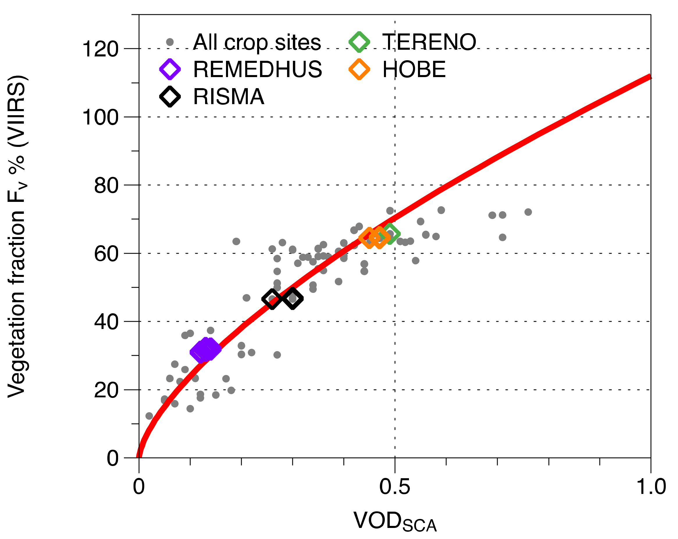
The parameter 𝛾 required in Equation (11) is determined from temporal average of τ S C A and VIIRS GVF measurements over the calibration sites (TERENO, HOBE, REMEDHUS, RISMA) as shown in Figure 2. The determined 𝛾 in this study is 1.12 for the GVF simulation (p-value from Wilcoxon rank sum test is 0.6817, which means our hypothesis is reliable enough).
The computation of the time-varying ω based on Equation (11) requires also the maximum ω m a x . For the new parameterization of forward model parameters, the time-varying ω was tuned via the optimal β (1.12) and ω m a x . According to Equation (14) and Figure 2, the effective scattering albedo or variational scattering albedo can range from 0 to 1.12 if VOD changes from 0 to 1. The results of the calibration and validation are presented in Table 2.

4.2. Quality Assessment of the New Parameterization in the τ-ω Model

We investigate if the τ-ω model error in the simulation of Tb is reduced by replacing the time-constant omega ( ω 0.05 ) with time-varying omega ( ω var ) that depends on the value of τ . Equation (11) indicates that a higher τ measured in a SMAP resolution cell is likely to have a higher effective value of omega;
Higher τ → larger vegetation fraction (less bare soil) in a grid → higher effective ω .
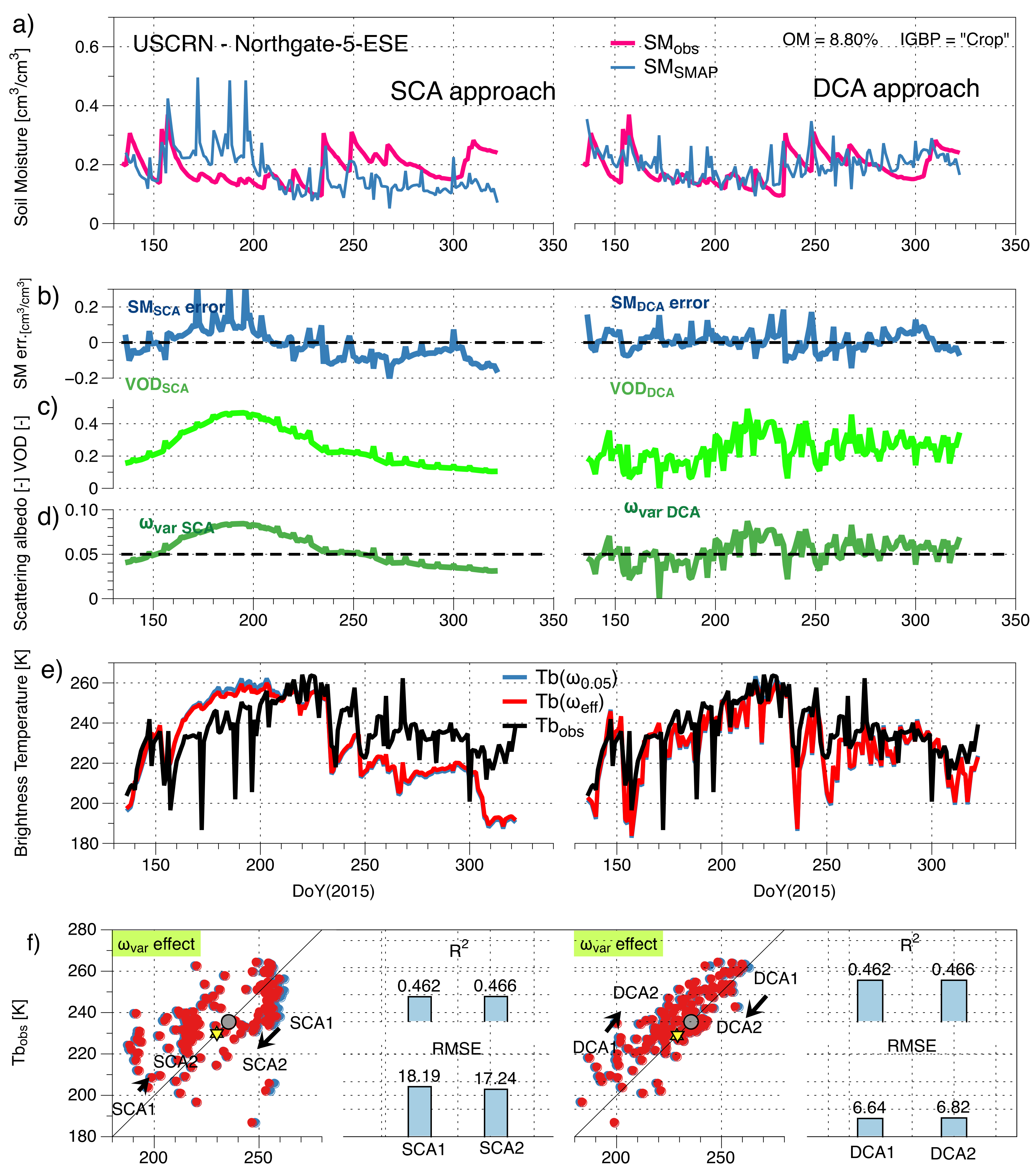
Figure 3a shows the significant overestimation of SMAP that SM RTMs can produce. Particularly, the SCA-based SM reached the limit value, up to 0.6 m3/m3 during half of the time-series. These errors (Figure 3b) were estimated by deducting in-situ SM and are temporally correlated with the varying ω (Figure 3c). The SM estimation is affected by the required ancillary parameters of vegetation, τ and ω . If one of the ancillaries is not realistic—in this study the time-constant ω —it will affect the SM estimation. In other words, one of the error sources in SM are the vegetation properties within RTM and this error is at least to a certain extent addressed with time- and space-varying ω . This result confirms the validity of the hypothesis that ω can be approximated with τ . The τ -derived ω was more than 0.1 and two times larger than the constant ω applied in SMAP baseline algorithm. We investigated the improvement by applying the time- and space-varying ω . The time series of Tb in (Figure 3e) shows that the overestimated Tb (blue) decreases in the Tb simulations with DMM (red curve). The effect of the new parameterization of ω in the τ-ω model is displayed in Figure 3f. The application of varying ω significantly reduces the Tb bias form SCA1 to SCA2. Over cropland (Figure 3a), this type of SM bias seems to be more of a serious issue in SCA- than DCA-based soil moisture retrievals. We can expect the unrealistically overestimated SM from both approaches will have a positive effect by applying varying ω during the SM estimation process from the measured Tb. The SMAP DCA SM estimates in the right panel of Figure 3a are close to 0.6 cm3/cm3 missing the seasonal SM evolution observed in-situ. The time-varying ω ranges between 0.08 and 0.12, which is a much larger value than the default value, 0.05. In addition to the large difference in the absolute value, a temporally varying pattern that exhibits a similar pattern of the SM error due to the constant ω . In this case, the application of the time-varying ω also significantly reduced the overestimation of Tb.
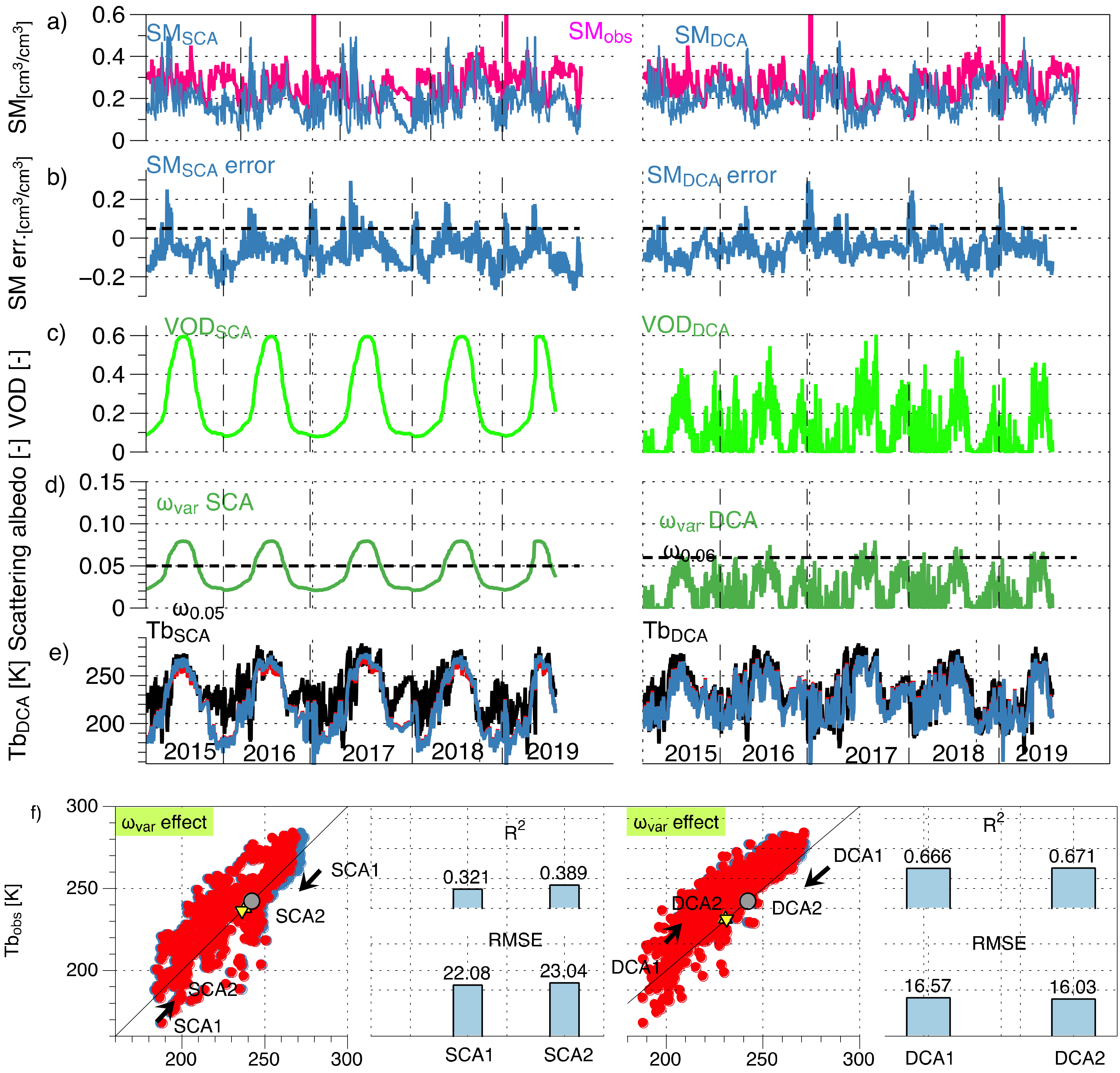
On the other hand, in the Figure 4, the overestimation of SM by using the constant ω in SMAP RTM is less severe than Figure 3 showing the limited SM value in all-time series in SCA approach. In this case, SM estimated by SCA is much closer to the in-situ SM than the one by DCA. The SCA τ used in the computation of ω (c) in Figure 4 is lower than the one in Figure 3. Still, the DCA τ of Figure 4 ranges from 0.8 to 0.12, which is similar to Figure 3. With given Tb and higher τ , the SM is higher in the simultaneous optimal estimation. It means that the DCA τ in Figure 4c should be lower. Particularly, DCA SM error becomes larger when τ was high in DOY approximately over 0.6, which leads to a DCA-based SM much higher than the in-situ in this period. Probably, the further improvement of DCA approach for simultaneous estimation of τ and SM can be expected in the minimization process finding optimal τ with the temporally varying ω than the constant ω .
As a result, SM estimated by the SMAPL2 SCA and DCA was overestimated as shown in Figure 3 and Figure 4a. The difference of the SMAP SM to the in-situ in Figure 4b shows the temporal correlation with the changes of the omega in DCA of Figure 3 and Figure 4. It means that both the SCA and DCA approaches suffer from a low value of ω ; DCA can detect the temporal changes of vegetation better, which is revealed in its SM error. The improvement in the Tb simulation is mostly originated from the overall larger value of the new ω in both SCA and DCA and less because of the temporal variance. This uncertainty is attributed to the scattering properties of the τ-ω model which was the reason we replaced the constant ω with the varying ω . The results in Figure 3 and Figure 4 suggest that the soil moisture estimations using the τ-ω model based on the fixed ω were mostly underestimated and the new ω is on a higher level than the constant one showing reduced bias compared to the measured Tb.
During the early growth and senesce period of the crop (soybean), the newly parameterized vegetation ω for cropland in Figure 5c decreases lower than the constant ω (0.05). This dynamic results in reduced SMAP SM estimation. Impacts include: (b) negative bias in SM, (c) low τ in growing and senescence season (d) a lower vegetation ω estimated from the τ .
Even though the improvement is not really significant as compared to the case presented in Figure 3 and Figure 4, the direction of the improvement is promising. The results show an increase of the Tb simulation when the SMAP SM has a negative bias, which occurs mostly during the growing and ripening season, and a decrease of the Tb simulation when the SMAP SM has a positive bias (similar to Figure 3 and Figure 4), which occurs mostly during the mature crop state. The crop phenology shows in the uncertainty (Figure 5a,b). It appears also in the cause (constant ω ) and solution (varying ω ) (Figure 5d) and the improvement (Figure 5e,f), reasonably. This temporal pattern has been shown not only in the case of USCRN crop case Figure 5 but also in other intensive field studies using SMAP Level 2 Enhanced Passive Soil Moisture [42] over croplands (corn) from 2015 to 2019 in Figure 6.
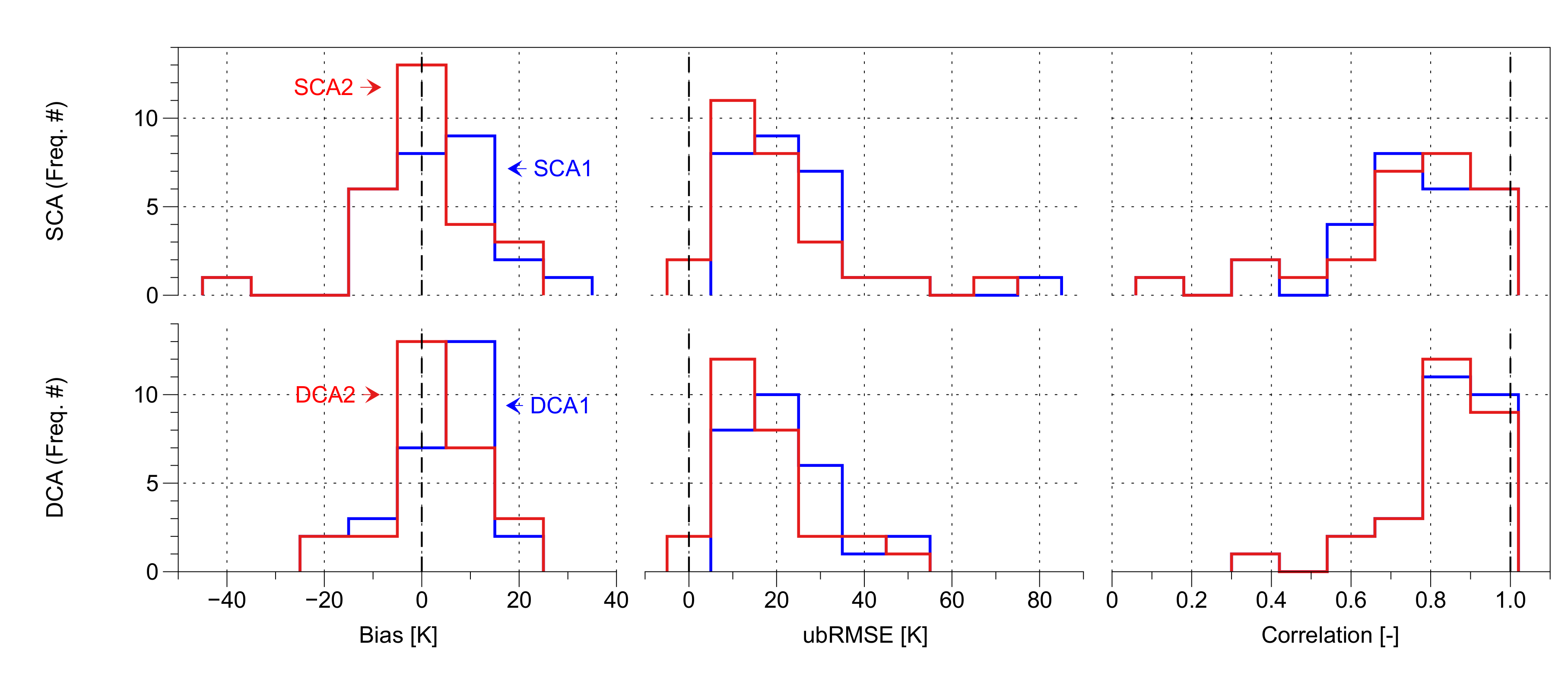
As a result, the vegetation ω variability in the newly parameterized τ-ω model improves the Tb simulation. Bias and ubRMSE (unbiased Root Mean Square Error) tend to decrease. Owing to this, the SM estimation from the SMAP Tb will be closer to the in-situ SM. Furthermore, the newly parameterized τ-ω model provides a more accurate observation operator for data assimilation, which would result in more accurate soil moisture update to NWP. The validation over the crop sites matched with 9km Tb products, showed a very little improvement by varying ω (SCA1→SCA2 and DCA1→DCA2). Further case studies have been performed and the results are summarized in Table 3.
Overall, the biases were reduced (SCA1→SCA2 and DCA1→DCA2) and ubRMSE becomes closer to zero for croplands as shown in Table 4 and Figure 7.
This study derived temporally variable ω from τ (green curves in Figure 3d, Figure 5d and Figure 6d), which is treated as a constant in DCA (black dotted) and MT-DCA. We investigated whether the time-varying ω actually leads to a more accurate RTM in terms of correlation and unbiased RMSE. As shown in the results of Table 4, the improvement by temporally varying ω is indicated by an ubRMSE decrease for SCA from 23.1 to 19.5 and for DCA from 21.3 to 18.1. Furthermore, the correlation score has improved for SCA from 0.725 to 0.732 but not for DCA from 0.836 to 0.832. As τ in SCA is pre-determined by the MODIS NDVI data, the improvement of ω is subsequently not affecting τ. On the other hand, in the DCA the optimal estimation of SM as well as τ is performed based on a constant ω. That means the ω improvement requires a simultaneous change in SM and τ accordingly in the optimization probably resulting in different ubRMSE and correlation in the later validation. More details on the validation statistics for the sites, used in Figure A1, can be found in Table A4 of Appendix B.

5. Discussions

As vegetation cover represents a critical source of uncertainty when estimating soil moisture underneath [21]. We identified in this study that the vegetation disturbance originated from the difference in VOD either from SCA or DCA. This causes the difference between SMSCA and SMDCA as presented in the results of Figure 3a, Figure 4a, Figure 5a and Figure 6a. Furthermore, we also found that if VOD of SCA or DCA is greater than 0.3 as shown in Figure 3c, Figure 4c, Figure 5c and Figure 6c, the constant scattering albedo (ω = 0.05) can be interpreted to be underestimated comparing to the variational ω derived from VOD. The underestimated and constant ω is probably one of the main reasons to contribute to the overestimation of SM as shown in Figure 3b, Figure 4b, Figure 5b and Figure 6b. The ω for both approaches is fixed to 0.05 for croplands which means 1) the vegetation is fully occupied within 36 km by 36km SMAP grid (i.e., vegetation fraction is 1 in every grid) and 2) only the optical depth is allowed to vary during vegetation development. Therefore, we hypothesized that an increasing τ is supposed to induce increasing ω according to allometric power-law function with the exponent, 2/3, in the vegetation phenological development. Another required factor is β , which determines the slope of the power-law function. This study improves the τ-ω model only for croplands and the β was empirically derived and applicable only for croplands. This is a limitation for the global application of the new approach. Furthermore, because even the crop type can be classified as C3 or C4, the β factor should be more specified. This limitation in the new approach, however, can be overcome with further specifying β according to crop types (C3 or C4) or forest types (needleleaf or broadleaf). This kind of experiment will hopefully provide a range of effective ω-value for various vegetation types.
However, if land use heterogeneity within the SMAP grid is severe, e.g., mixed forest or partially urban areas included, the presented approach might not work properly and further inclusion of information about urban area fraction is required for the τ-ω approach before computing the effective scattering albedo over bare and vegetated areas. In addition, the τ-ω model is based on the assumption of single scattering albedo. Higher-order scattering scheme should be considered such as the 1st order τ-ω model, proposed in the recent study [43].
Regardless of those limitations, the improvement by time- and space-varying ω appeared in cropland case studies of SCRN in an unexpected way. A τ increase in RTM causes a Tb increase in the simulation, but ω-increase induced Tb to decrease. As they change Tb with the opposite directions, the overall effect on Tb is less than when only the τ increase is accounted for. We investigated whether or not this new interplay between vegetation properties (τ and ω) and the emitted microwave Tb measured in SMAP leads to improvements in the accuracy of the Tb simulations. The results showed that the temporal variability of simulated Tb with the time-varying ω improved the correlation and ubRMSE compared to the measured Tb as shown in the histogram of the validation results in Figure 7. In the time series, when ω drops below 0.05 in spring and winter seasons, the simulated Tb decreases more than the default simulation in most cases and, in the summer, the ω becomes greater than 0.05, with an opposite effect on the simulated Tb, as shown in Figure 5. This is the reason why time-varying ω improved the ubRMSE in time series analysis. Regarding the ω-change on average, the overall bias in the Tb simulation was improved. The average of the computed time-varying ω was larger than the default ω of 0.05. These results agree with the spatially varying ω product recently computed by MT-DCA [19].

6. Summary and Outlook

In this study, we found that the soil moisture retrieved with SCA and DCA from the SMAP mission suffers from over- and under-estimations for cropland sites. In order to tackle this bias, we derived a time-varying omega (ωvar) based on the assumption of a power-law relationship between GVF and VOD instead of a time-constant omega (ω0.05), as used in the SMAP baseline algorithms (SCA and DCA). The formulation allows us to express a time-varying omega ωvar based on the temporal dynamics of τ. Hence, ωvar is able to account at least partly for the temporal variation of the vegetation properties in cropland. In this study, we focused on linking the measured VOD and the effective value of omega (effective single scattering albedo) mainly via vegetation volumetric traits such as the height and area fraction within the measured resolution cell. The assessment was performed with the SMAPL2 brightness temperature (Tb). It is matched with the forward modeled brightness temperature using input from in-situ stations of the USCRN (27 croplands (11 corn, 7 soybean, 2 cotton, grapes, alfalfa, 1 wheat, citrus, unknown sites)) in 2015 and in the SMAPL2 Enhanced H-pol brightness core validation sites (3 cropland) from 2015 to 2019.
As one conclusion, we were able to reduce the positive Tb bias for several reference sites over cropland (C1, 3–11, 13–17, 20, 22, 25, 27 d in Table A4) including Gadsden-19-N (Atlanta) and Durham-2-N (Boston) presented in Figure 3 and Figure 4. This bias reduction mitigates the overestimation of Tb (K) by 80% and 35% in the SCA and DCA approach, respectively. These results demonstrate that owing to a different phenology of the VOD time series over cropland, the time-varying omega parametrized with VOD can implement a more realistic τ-ω model simulation than the one applied with constant omega in SCA and DCA approaches.
In a future study, further experiments will be performed including organic matter (OM) to the applied dielectric mixing model [44]. The soil moisture of USCRN used for validation in this study was also estimated based on probe algorithm [45], where the soil organic matter is not considered. We would like to recall that this missing consideration in the reference soil moisture values might affect the validation of Tb simulations.
One key feature of the approach is that no more variables are added with this new parameterization of the τ-ω model contributing to a more accurate but less complex global soil moisture estimation. This is equally important for retrieval and data assimilation approaches based on microwave brightness temperature measurements, e.g., from SMOS or AMSR-2.
As satellite remote sensing is the only operational way to determine global soil moisture, an accurate radiative transfer model for soil moisture estimation is essential. We propose that the presented parameterization for a time-varying vegetation scattering albedo from VOD dynamics implemented within the τ-ω model provides more realistic retrievals of soil moisture dynamics. Even for air-borne applications which are capable to measure in higher spatial resolution than satellite applications, the temporally constant omega within the applied RTM can cause the temporally heterogeneous issue in the Tb simulation regardless of the spatially unique omega obtained. The previous approach including the most recent approach, MT-DCA, can suffer from this temporally constant omega issue in the application of air-borne remote sensing. The here proposed approach can be a way to resolve for both spatial and temporal heterogeneity of vegetation parameters, like ω, in space-borne as well as air-borne remote sensing applications.

Author Contributions

Conceptualization, C.-H.P., J.L. and V.W.; data curation, A.C., A.B., M.C. and S.-b.K.; formal analysis, C.-H.P. and T.J.; funding acquisition, J.L. and Y.K.; investigation, Y.K.; methodology, C.-H.P.; resources, C.-H.P., J.L. and S.-b.K.; validation, C.-H.P., A.C., A.B., M.C. and S.-b.K.; visualization, C.-H.P. and T.J.; writing—original draft, C.-H.P.; writing—review and editing, T.J., A.C., J.L., A.B., M.C. and V.W. All authors have read and agreed to the published version of the manuscript.

Funding

This work was funded by the Korea Meteorological Administration Research and Development Program “Development of Climate Prediction System” under Grant (KMA2018-00322). A partial contribution to this work was made at the Jet Propulsion Laboratory, California Institute of Technology under a contract with the National Aeronautics and Space Administration. USDA is an equal opportunity employer and provider.

Acknowledgments

The authors specially thank Howard J. Diamond for providing the data of soil properties over USCRN sites and his valuable advices for this study.

Conflicts of Interest

The authors declare no conflict of interest.

Appendix A. Data Description

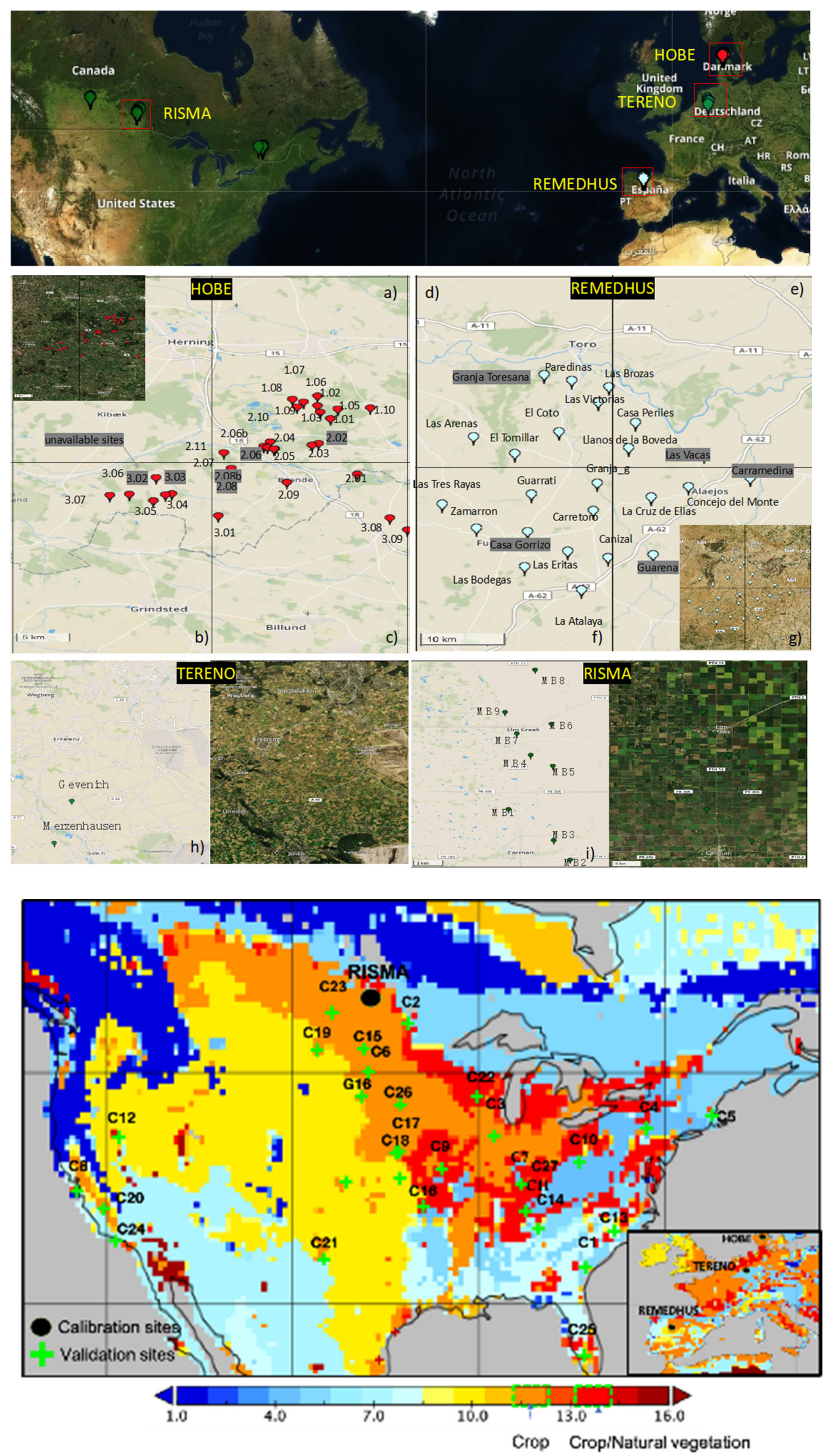
Figure A1. Map of ISMN (International Soil Moisture Network) sites [46] for calibration (upper panel), (ac) for HOBE, (dg) for REMEDHUS, (h) for TERENO, (i) for RISMA; and validation in USCRN sites (lower panel) over the IGBP (International Geosphere-Biosphere Programme) land classification based on MODIS measurements obtained from SMAP L4 (orange (IGBP 12): croplands and red (IGBP 14): cropland/natural vegetation).
Remotesensing 12 02939 g0a1
Table A1. Data used for Tb calibration over croplands.
Calibration SitesCrop SiteClay
[cm3/cm3]
Sand
[cm3/cm3]
Silt
[cm3/cm3]
OM (%)
HOBE [47]1.020.040.870.0927.86
1.030.040.870.0927.86
1.050.040.870.0927.86
1.060.040.870.0927.86
1.070.040.870.0927.86
1.080.040.870.0927.86
1.090.040.870.0927.86
1.100.040.870.0927.86
2.010.040.870.0928.03
2.030.040.870.0928.03
2.040.040.870.0928.03
2.050.040.870.0928.03
2.06b0.040.870.0928.03
2.070.040.870.0928.03
2.090.040.870.0928.03
2.100.040.870.0928.03
2.110.040.870.0928.03
3.010.040.870.0928.03
3.040.040.870.0928.03
3.050.040.870.0928.03
3.060.040.870.0928.03
3.070.040.870.0928.03
3.080.10.810.0927.62
3.090.10.810.0927.62
REMEDHUS [48]Canizal0.490.190.322.95
Carretoro0.180.340.483.12
CasaPeriles0.210.360.433.12
ConcejodelMonte0.210.360.433.62
ElCoto0.180.340.483.12
ElTomillar0.490.190.323.12
Guarrati0.180.340.483.12
LaAtalaya0.490.190.322.95
LaCruzdeElias0.490.190.323.12
LasArenas0.490.190.323.38
LasBodegas0.210.360.432.95
LasBrozas0.490.190.323.12
LasEritas0.490.190.322.95
LasTresRayas0.490.190.323.38
LasVictorias0.490.190.323.12
LlanosdelaBoveda0.210.360.433.12
Paredinas0.210.360.433.12
Zamarron0.490.190.324.36
TERENO [49]Gevenich0.220.410.3715.13
Merzenhausen0.220.410.3715.13
RISMA [50]MB10.410.120.4713.59
MB20.410.120.4711.25
MB30.410.120.4714.28
MB40.410.120.4714.28
MB50.410.120.4714.28
MB60.410.120.4714.28
MB70.410.120.4713.59
MB80.410.120.4715.68
MB90.410.120.4713.58
Table A2. Data used for validation over croplands.
Validation SitesIDClay
[cm3/cm3]
Sand
[cm3/cm3]
Silt
[cm3/cm3]
OM (%)Crop
Type
Blackville-3-WC10.230.470.316.33Cotton
Goodridge-12-NNWC20.220.380.418.42Soybean
Shabbona-5-NNEC30.240.350.418.47Corn
Ithaca-13-EC40.20.410.3940.15Corn
Kingston-1-NWC50.050.850.155.06Corn
Aberdeen-35-WNWC60.230.360.415.76Corn
Bedford-5-WNWC70.240.490.2714.41Soybean *
Bodega-6-WSWC80.230.390.380.00Grapes
Chillicothe-22-ENEC90.240.350.417.37Soybean
Coshocton-8-NNEC100.20.410.3918.11Corn
Crossville-7-NWC110.240.490.2716.69Corn
Denio-52-WSWC120.230.360.413.39Alfalfa
Durham-2-NC130.130.490.3852.60Corn
Gadsden-19-NC140.240.490.2712.76Soybean
Jamestown-38-WSWC150.090.720.197.88Soybean
Joplin-24-NC160.240.350.4113.52Soybean *
Lincoln-11-SWC170.240.350.413.91Corn *
Lincoln-8-ENEC180.240.350.412.72Corn *
Medora-7-EC190.220.430.355.04Wheat
Merced-23-WSWC200.20.390.417.57Alfalfa
Muleshoe-19-SC210.210.50.291.13Cotton
Necedah-5-WNWC220.060.830.1119.47Corn
Northgate-5-ESEC230.230.360.418.80-
Santa-Barbara-11-WC240.240.470.290.00Grapes
Sebring-23-SSEC250.080.820.127.59citrus
Sioux-Falls-14-NNEC260.230.390.383.82Corn *
Versailles-3-NNWC270.240.470.2914.43Soybean
The crop type information was extracted from the 30 m resolution Cropland Data Layer database [51] within SMAP’s 36 km grid boundaries for the year 2015 (*: both corn and soybean are dominated within the SMAP grid).

Appendix B. Validation Results

Table A3. Data used for Tb validation with SMAPL2 Enhanced H-pol brightness temperature.
Site NameState, CountryPI(s)Land Cover# of SensorsReferences
South ForkIA, USACoshCropland (corn)20[52]
KenastonSaskatchewan, CanadaBerg, Rowlandsoncropland28[53]
CarmanManitoba, CanadaMcNairn, Pachecocropland9[50]
Table A4. Validation scores over USCRN cropland.
#BiasubRMSECorrelation
S1S2D1D2S1S2D1D2S1S2D1D2
C111.57.113.89.323.3414.6327.7219.110.9720.9710.9850.967
C2−6.56.2−3.62.625.2524.4710.208.760.0650.0990.9320.932
C313.611.8−7.26.531.5428.9221.8820.350.5680.4960.5460.579
C44.50.65.51.89.63.511.454.470.9320.9330.9600.972
C52.30.98.82.819.535.6317.996.460.580.790.8060.801
C69.99.97.38.622.7222.5117.2819.460.7680.7820.8900.888
C75.30.47.73.911.524.4415.718.600.9080.9150.9570.959
C80.0−5.4−3.22.619.8822.6620.3920.240.3400.333Z0.348
C95.93.90.50.514.2910.738.558.130.8830.8960.8850.889
C104.80.39.25.410.865.3719.0811.880.8710.8320.8910.893
C115.12.49.20.110.675.5518.532.410.9480.9470.9620.968
C12−10.710.02.42.725.4524.2813.1813.280.6820.6840.7380.746
C1314.93.96.52.330.7110.6915.148.970.7240.7250.7380.723
C147.24.013.27.015.129.1526.5014.480.9180.9150.9800.955
C1515.215.214.415.532.4932.2329.8932.000.7440.7570.9040.900
C161.40.8−1.70.88.828.3810.759.920.9130.9200.9000.899
C170.40.0−5.84.512.6512.1917.6716.370.8120.8150.8720.871
C181.2−2.1−12.711.415.0015.0327.1024.670.6910.6950.9000.902
C19−5.44.45.87.216.1214.8414.5116.870.5820.5890.7870.788
C2017.318.020.621.936.2737.6442.4844.950.8530.8530.8840.887
C21−37.736.6−21.520.876.9774.8045.0343.720.7610.7600.8250.825
C2213.68.413.18.827.7117.5026.6318.320.8550.8470.8950.838
C23−7.87.70.92.222.7021.826.857.830.6800.6830.8750.876
C246.5−6.53.84.915.7215.8210.3612.130.3490.3540.5510.545
C2526.223.922.623.253.6449.2546.7347.820.5490.5530.7090.687
C269.0−10.2−16.115.026.5927.4034.5632.600.7300.7240.8650.864
C272.80.48.76.48.416.3618.0213.520.8890.8830.9370.952
The stressed values indicate better score.

References

  1. Vitart, F.; Ardilouze, C.; Bonet, A.; Brookshaw, A.; Chen, M.; Codorean, C.; Déqué, M.; Ferranti, L.; Fucile, E.; Fuentes, M.; et al. The Subseasonal to Seasonal (S2S) Prediction Project Database. Bull. Am. Meteorol. Soc. 2017, 98, 163–173. [Google Scholar] [CrossRef]
  2. Mariotti, A.; Ruti, P.M.; Rixen, M. Progress in Subseasonal to Seasonal Prediction through a Joint Weather and Climate Community Effort. Npj Clim. Atmos. Sci. 2018, 1, 1–4. [Google Scholar] [CrossRef]
  3. Yoon, J.-H.; Leung, L.R. Assessing the Relative Influence of Surface Soil Moisture and ENSO SST on Precipitation Predictability over the Contiguous United States. Geophys. Res. Lett. 2015, 42, 5005–5013. [Google Scholar] [CrossRef]
  4. Santanello, J.A.; Dirmeyer, P.A.; Ferguson, C.R.; Findell, K.L.; Tawfik, A.B.; Berg, A.; Ek, M.; Gentine, P.; Guillod, B.P.; van Heerwaarden, C.; et al. Land-Atmosphere Interactions the LoCo Perspective. Am. Meteorol. Soc. 2018, 1, 1253–1272. [Google Scholar] [CrossRef]
  5. Santanello Jr, J.A.; Lawston, P.; Kumar, S.; Dennis, E. Understanding the Impacts of Soil Moisture Initial Conditions on NWP in the Context of Land–Atmosphere Coupling. J. Hydrometeorol. 2019, 20, 793–819. [Google Scholar] [CrossRef]
  6. Reichle, R.H.; Koster, R.D.; Dong, J.; Berg, A.A.; Reichle, R.H.; Koster, R.D.; Dong, J.; Berg, A.A. Global Soil Moisture from Satellite Observations, Land Surface Models, and Ground Data: Implications for Data Assimilation. J. Hydrometeorol. 2004, 5, 430–442. [Google Scholar] [CrossRef]
  7. Reichle, R.H.; de Lannoy, G.J.M.; Liu, Q.; Koster, R.D.; Kimball, J.S.; Crow, W.T.; Ardizzone, J.V.; Chakraborty, P.; Collins, D.W.; Conaty, A.L.; et al. Global Assessment of the SMAP Level-4 Surface and Root-Zone Soil Moisture Product Using Assimilation Diagnostics. J. Hydrometeorol. 2017, 18, 3217–3237. [Google Scholar] [CrossRef]
  8. Reichle, R.H.; de Lannoy, G.J.M.; Liu, Q.; Ardizzone, J.V.; Chen, F.; Colliander, A.; Conaty, A.; Crow, W.; Jackson, T.; Kimball, J.; et al. Global Modeling and Assimilation Office Soil Moisture Active Passive Mission L4_SM Data Product Assessment (Version 2 Validated Release); NASA: Washington, DC, USA, 2016. [Google Scholar]
  9. Reichle, R.H.; Ardizzone, J.v.; Kim, G.-K.; Lucchesi, R.A.; Smith, E.B.; Weiss, B.H. Global Modeling and Assimilation Office. Soil Moisture Active Passive (SMAP) Mission Level 4 Surface and Root Zone Soil Moisture (L4_SM) Product Specification Document; NASA: Washington, DC, USA, 2018. [Google Scholar]
  10. De Lannoy, G.J.M.; Reichle, R.H. Assimilation of SMOS Brightness Temperatures or Soil Moisture Retrievals into a Land Surface Model. Hydrol. Earth Syst. Sci. 2016, 20, 4895–4911. [Google Scholar] [CrossRef] [Green Version]
  11. De Lannoy, G.J.M.; Reichle, R.H. Global Assimilation of Multiangle and Multipolarization SMOS Brightness Temperature Observations into the GEOS-5 Catchment Land Surface Model for Soil Moisture Estimation. J. Hydrometeorol. 2016, 17, 669–691. [Google Scholar] [CrossRef] [Green Version]
  12. De Rosnay, P.; Calvet, J.C.; Kerr, Y.; Wigneron, J.P.; Lemaître, F.; Escorihuela, M.J.; Sabater, J.M.; Saleh, K.; Barrié, J.; Bouhours, G.; et al. SMOSREX: A Long Term Field Campaign Experiment for Soil Moisture and Land Surface Processes Remote Sensing. Remote Sens. Environ. 2006, 102, 377–389. [Google Scholar] [CrossRef]
  13. Jackson, T.J.; Schmugge, J.; Engman, E.T. Application de La Télédétection à l’hydrologie: L’humidité Du Sol. Hydrol. Sci. J. 1996, 41, 517–530. [Google Scholar] [CrossRef]
  14. Wigneron, J.P.; Calvet, J.C.; Pellarin, T.; van de Griend, A.A.; Berger, M.; Ferrazzoli, P. Retrieving Near-Surface Soil Moisture from Microwave Radiometric Observations: Current Status and Future Plans. Remote Sens. Environ. 2003, 489–506. [Google Scholar] [CrossRef]
  15. Mo, T.; Choudhury, B.J.; Schmugge, T.J.; Wang, J.R.; Jackson, T.J. A Model for Microwave Emission from Vegetation-Covered Fields. J. Geophys. Res. 1982, 87, 11229. [Google Scholar] [CrossRef]
  16. Chan, S.K.; Bindlish, R.; O’Neill, P.; Jackson, T.; Njoku, E.; Dunbar, S.; Chaubell, J.; Piepmeier, J.; Yueh, S.; Entekhabi, D.; et al. Development and Assessment of the SMAP Enhanced Passive Soil Moisture Product. Remote Sens. Environ. 2018, 204, 931–941. [Google Scholar] [CrossRef] [Green Version]
  17. Rodríguez-Fernández, N.J.; Mialon, A.; Mermoz, S.; Bouvet, A.; Richaume, P.; al Bitar, A.; Al-Yaari, A.; Brandt, M.; Kaminski, T.; le Toan, T.; et al. An Evaluation of SMOS L-Band Vegetation Optical Depth (L-VOD) Data Sets: High Sensitivity of L-VOD to above-Ground Biomass in Africa. Biogeosciences 2018, 15, 4627–4645. [Google Scholar] [CrossRef] [Green Version]
  18. Owe, M.; de Jeu, R.; Walker, J. A Methodology for Surface Soil Moisture and Vegetation Optical Depth Retrieval Using the Microwave Polarization Difference Index. IEEE Trans. Geosci. Remote Sens. 2001, 39, 1643–1654. [Google Scholar] [CrossRef] [Green Version]
  19. Konings, A.G.; Piles, M.; Rötzer, K.; McColl, K.A.; Chan, S.K.; Entekhabi, D. Vegetation Optical Depth and Scattering Albedo Retrieval Using Time Series of Dual-Polarized L-Band Radiometer Observations. Remote Sens. Environ. 2016, 172, 178–189. [Google Scholar] [CrossRef]
  20. Zwieback, S.; Colliander, A.; Cosh, M.H.; Martínez-Fernándezj, J.; McNairn, H.; Starks, P.J.; Thibeault, M.; Berg, A. Estimating time-dependent vegetation biases in the SMAP soil moisture product. Hydrol. Earth Sys. Sci. 2018, 22, 4473–4489. [Google Scholar] [CrossRef] [Green Version]
  21. Jackson, T.J.; Schmugge, T.J. Vegetation Effects on the Microwave Emission of Soils. Remote Sens. Environ. 1991, 36, 203–212. [Google Scholar] [CrossRef]
  22. Konings, A.G.; Piles, M.; Das, N.; Entekhabi, D. L-Band Vegetation Optical Depth and Effective Scattering Albedo Estimation from SMAP. Remote Sens. Environ. 2017, 198, 460–470, doi;101016/jrse201706037. [Google Scholar] [CrossRef]
  23. Jiang, L.; Kogan, F.N.; Guo, W.; Tarpley, J.D.; Mitchell, K.E.; Ek, M.B.; Tian, Y.; Zheng, W.; Zou, C.Z.; Ramsay, B.H. Real-Time Weekly Global Green Vegetation Fraction Derived from Advanced Very High Resolution Radiometer-Based NOAA Operational Global Vegetation Index (GVI) System. J. Geophys. Res. 2010, 115, D11114. [Google Scholar] [CrossRef]
  24. Asner, G.P.; Mascaro, J.; Anderson, C.; Knapp, D.E.; Martin, R.E.; Kennedy-Bowdoin, T.; van Breugel, M.; Davies, S.; Hall, J.S.; Muller-Landau, H.C.; et al. High-Fidelity National Carbon Mapping for Resource Management and REDD+. Carbon Balance Manag. 2013, 8, 1–14. [Google Scholar] [CrossRef] [PubMed] [Green Version]
  25. Asner, G.P.; Mascaro, J. Mapping Tropical Forest Carbon: Calibrating Plot Estimates to a Simple LiDAR Metric. Remote Sens. Environ. 2014, 140, 614–624. [Google Scholar] [CrossRef]
  26. Chave, J.; Réjou-Méchain, M.; Búrquez, A.; Chidumayo, E.; Colgan, M.S.; Delitti, W.B.C.; Duque, A.; Eid, T.; Fearnside, P.M.; Goodman, R.C.; et al. Improved Allometric Models to Estimate the Aboveground Biomass of Tropical Trees. Glob. Chang. Biol. 2014, 20, 3177–3190. [Google Scholar] [CrossRef] [PubMed]
  27. Chambers, J.Q.; dos Santos, J.; Ribeiro, R.J.; Higuchi, N. Tree Damage, Allometric Relationships, and above-Ground Net Primary Production in Central Amazon Forest. For. Ecol. Manag. 2001, 152, 73–84. [Google Scholar] [CrossRef]
  28. Chave, J.; Andalo, C.; Brown, S.; Cairns, M.A.; Chambers, J.Q.; Eamus, D.; Fölster, H.; Fromard, F.; Higuchi, N.; Kira, T.; et al. Tree Allometry and Improved Estimation of Carbon Stocks and Balance in Tropical Forests. Oecologia 2005, 145, 87–99. [Google Scholar] [CrossRef]
  29. Jagdhuber, T.; Konings, A.G.; McColl, K.A.; Alemohammad, S.H.; Das, N.N.; Montzka, C.; Link, M.; Akbar, R.; Entekhabi, D. Physics-Based Modeling of Active and Passive Microwave Covariations over Vegetated Surfaces. IEEE Trans. Geosci. Remote Sens. 2019, 57, 788–802. [Google Scholar] [CrossRef]
  30. Norman, J.M.; Kustas, W.P.; Humes, K.S. Source Approach for Estimating Soil and Vegetation Energy Fluxes in Observations of Directional Radiometric Surface Temperature. Agric. For. Meteorol. 1995, 77, 263–293. [Google Scholar] [CrossRef]
  31. Chaubell, M.J.; Asanuma, J.; Berg, A.A.; Bosch, D.D.; Caldwell, T.; Cosh, M.H.; Collins, C.H.; Martinez-Fernandez, J.; Seyfried, M.; Starks, P.J.; et al. Improved SMAP Dual-Channel Algorithm for the Retrieval of Soil Moisture. IEEE Trans. Geosci. Remote Sens. 2020, 58, 3894–3905. [Google Scholar] [CrossRef]
  32. Fernandez-Moran, R.; Wigneron, J.P.; Lopez-Baeza, E.; Al-Yaari, A.; Coll-Pajaron, A.; Mialon, A.; Miernecki, M.; Parrens, M.; Salgado-Hernanz, P.M.; Schwank, M.; et al. Roughness and Vegetation Parameterizations at L-Band for Soil Moisture Retrievals over a Vineyard Field. Remote Sens. Environ. 2015, 170, 269–279. [Google Scholar] [CrossRef]
  33. Fernandez-Moran, R.; Al-Yaari, A.; Mialon, A.; Mahmoodi, A.; al Bitar, A.; de Lannoy, G.; RodriguezFernandez, N.; Lopez-Baeza, E.; Kerr, Y.; Wigneron, J.-P. SMOS-IC: An Alternative SMOS Soil Moisture and Vegetation Optical Depth Product. Remote Sens. 2017, 9, 457. [Google Scholar] [CrossRef] [Green Version]
  34. Pellarin, T.; Wigneron, J.P.; Calvet, J.C.; Waldteufel, P. Global Soil Moisture Retrieval from a Synthetic L-Band Brightness Temperature Data Set. J. Geophys. Res. Atmos. 2003, 108. [Google Scholar] [CrossRef]
  35. Pellarin, T.; Tran, T.; Cohard, J.-M.; Galle, S.; Laurent, J.-P.; de Rosnay, P.; Vischel, T. Soil Moisture Mapping over West Africa with a 30-Min Temporal Resolution Using AMSR-E Observations and a Satellite-Based Rainfall Product. Hydrol. Earth Sys. Sci. 2009, 13, 1887–1896. [Google Scholar] [CrossRef] [Green Version]
  36. Wigneron, J.-P.; Pellarin, T.; Calvet, J.-C.; de Rosnay, P.; Saleh, K.; Waldteufel, P.; Kerr, Y. L-MEB: A Simple Model at L-Band for the Continental Areas—Application to the Simulation of a Half-Degree Resolution and Global Scale Dataset. 2006. Available online: https://hal.inrae.fr/hal-02820857/document (accessed on 10 September 2020).
  37. Bell, J.E.; Palecki, M.A.; Baker, C.B.; Collins, W.G.; Lawrimore, J.H.; Leeper, R.D.; Hall, M.E.; Kochendorfer, J.; Meyers, T.P.; Wilson, T.; et al. Climate Reference Network Soil Moisture and Temperature Observations. J. Hydrometeorol. 2013, 14, 977–988. [Google Scholar] [CrossRef]
  38. Park, C.-H.; Behrendt, A.; LeDrew, E.; Wulfmeyer, V. New Approach for Calculating the Effective Dielectric Constant of the Moist Soil for Microwaves. Remote Sens. 2017, 9, 732. [Google Scholar] [CrossRef] [Green Version]
  39. Chan, S.K.; Bindlish, R.; O’Neill, P.E.; Njoku, E.; Jackson, T.; Colliander, A.; Chen, F.; Burgin, M.; Dunbar, S.; Piepmeier, J.; et al. Assessment of the SMAP Passive Soil Moisture Product. IEEE Trans. Geosci. Remote Sens. 2016, 54, 4994–5007. [Google Scholar] [CrossRef]
  40. O’Neill, P.; Entekhabi, D.; Njoku, E.; Kellogg, K. The NASA Soil Moisture Active Passive (SMAP) Mission: Overview. In Proceedings of the IEEE International Geoscience and Remote Sensing Symposium (IGARSS 2010), Honolulu, HI, USA, 25–30 July 2010. [Google Scholar] [CrossRef]
  41. SMAP L2 Radiometer Half-Orbit 36 km EASE-Grid Soil Moisture, Version 6; National Snow and Ice Data: Boulder, CO, USA, 2019; Available online: https://nsidc.org/data/SPL2SMP/versions/6 (accessed on 4 June 2020).
  42. Colliander, A.; Jackson, T.J.; Bindlish, R.; Chan, S.; Das, N.; Kim, S.B.; Cosh, M.H.; Dunbar, R.S.; Dang, L.; Pashaian, L.; et al. Validation of SMAP Surface Soil Moisture Products with Core Validation Sites. Remote Sens. Environ. 2017, 191, 215–231. [Google Scholar] [CrossRef]
  43. Feldman, A.F.; Akbar, R.; Entekhabi, D. Characterization of higher-order scattering from vegetation with SMAP measurements. Remote Sens. Environ. 2018, 219, 324–338. [Google Scholar] [CrossRef]
  44. Park, C.; Montzka, C.; Jagdhuber, T.; Jonard, F.; de Lannoy, G.; Hong, J.; Jackson, T.J.; Wulfmeyer, V.A. Dielectric Mixing Model Accounting for Soil Organic Matter. Vadose Zone J. 2019, 18, 190036. [Google Scholar] [CrossRef]
  45. Seyfried, M.S.; Grant, L.E.; Du, E.; Humes, K. Dielectric Loss and Calibration of the Hydra Probe Soil Water Sensor. Vadose Zone J. 2005, 4, 1070–1079. [Google Scholar] [CrossRef]
  46. Dorigo, W.A.; Xaver, A.; Vreugdenhil, M.; Gruber, A.; Hegyiová, A.; Sanchis-Dufau, A.D.; Zamojski, D.; Cordes, C.; Wagner, W.; Drusch, M. Global Automated Quality Control of In Situ Soil Moisture Data from the International Soil Moisture Network. Vadose Zone J. 2012, 12. [Google Scholar] [CrossRef]
  47. Bircher, S.; Skou, N.; Jensen, K.H.; Walker, J.P.; Rasmussen, L.; Verhoest, N. A soil moisture and temperature network for SMOS validation in Western Denmark. Hydrol. Earth Sys. Sci. 2012, 16, 1445–1463. [Google Scholar] [CrossRef] [Green Version]
  48. Sanchez, N.; Martínez-Fernández, J.; Scaini, A.; Perez-Gutierrez, C. Validation of the SMOS L2 soil moisture data in the REMEDHUS network (Spain). IEEE Trans. Geosci. Remote Sens. 2012, 50, 1602–1611. [Google Scholar] [CrossRef]
  49. Bogena, H.R.; Montzka, C.; Huisman, J.A.; Graf, A.; Schmidt, M.; Stockinger, M.; von Hebel, C.; Hendricks-Franssen, H.J.; van der Kruk, J.; Tappe, W.; et al. The TERENO-Rur hydrological observatory: A multiscale multi-compartment research platform for the advancement of hydrological science. Vadose Zone J. 2018, 17, 1–22. [Google Scholar] [CrossRef]
  50. Bhuiyan, H.A.; McNairn, H.; Powers, J.; Friesen, M.; Pacheco, A.; Jackson, T.J.; Cosh, M.H.; Colliander, A.; Berg, A.; Rowlandson, T.; et al. Assessing SMAP soil moisture scaling and retrieval in the Carman (Canada) study site. Vadose Zone J. 2018, 17, 1–14. [Google Scholar] [CrossRef] [Green Version]
  51. Johnson, D.; Mueller, R. The 2009 Cropland Data Layer. Photogramm. Eng. Remote Sens. 2010, 76, 1201–1205. [Google Scholar]
  52. Coopersmith, E.J.; Cosh, M.H.; Petersen, W.A.; Prueger, J.; Niemeier, J.J. Soil Moisture Model Calibration and Validation: An ARS Watershed on the South Fork Iowa River. J. Hydrometeorol. 2015, 16, 1087–1101. [Google Scholar] [CrossRef]
  53. Tetlock, E.; Toth, B.; Berg, A.; Rowlandson, T.; Ambadan, J.T. An 11-Year (2007–2017) Soil Moisture and Precipitation Dataset from the Kenaston Network in the Brightwater Creek Basin, Saskatchewan, Canada. Earth Sys. Sci. Data 2019, 11, 787–796. [Google Scholar] [CrossRef] [Green Version]
Figure 1. Simulation of brightness temperatures (Tb) using the (a) classical τ-ω model with time-constant ω, (b) time-varying parameterization of the τ-ω model with variable ω (DMM: dielectric mixing model)
Remotesensing 12 02939 g001
Figure 2. Scatter plot with vegetation optical depth single channel algorithm (VOD-SCA) and the measured vegetation fraction (VIIRS) over croplands (grapy points and colored diamond) and Green Vegetation Fraction (GVF) simulation with the VOD ranged from 0 to 1 by Equation (13) (red curve).
Remotesensing 12 02939 g002
Figure 3. Validation of the improvement by applying time-varying ω within SCA and dual-channel algorithm (DCA) approaches; (a) the soil moisture estimation by SCA (left) and DCA (right), (b) their uncertainty, (c) SCA and DCA VOD, (d) the constant adapted by the Soil Moisture Active Passive (SMAP) algorithm and the proposed time-varying ω. (e) The brightness temperature simulated by τ-ω model applied with the constant and time-varying ω from (d) and the input of the in-situ soil moisture presented in (a) in the U.S. Surface Climate Observing Reference Network (USCRN) Durham-2-N (crop type: corn). (f) ▲: mean SCA and DCA 1, ▼: mean SCA and DCA2, ●: mean SMAP Tb measurements, →: direction of change from mean SCA and DCA1 to SCA and DCA2 towards the reference Tb.
Remotesensing 12 02939 g003
Figure 4. Validation of the improvement by applying time-varying ω within SCA and DCA approaches; (a) the soil moisture estimation by SCA (left) and DCA (right), (b) their uncertainty, (c) SCA and DCA VOD, (d) the constant adapted by the SMAP algorithm and the proposed time-varying ω. (e) The brightness temperature simulated by τ-ω model applied with the constant and time-varying ω from (d) and the input of the in-situ soil moisture presented in (a) in USCRN Gadsden-19-N (crop type: soybean). (f) ▲: mean SCA and DCA1, ▼: mean SCA and DCA2, ●: mean SMAP Tb measurements, →: direction of change from mean SCA and DCA1 to SCA and DCA2 towards the reference Tb.
Remotesensing 12 02939 g004
Figure 5. Validation of the improvement by applying time-varying ω within SCA and DCA approaches; (a) the soil moisture estimation by SCA (left) and DCA (right), (b) their uncertainty, (c) SCA and DCA VOD, (d) the constant adapted by the SMAP algorithm and the proposed time-varying ω. (e) The brightness temperature simulated by τ-ω model applied with the constant and time-varying ω from (d) and the input of the in-situ soil moisture presented in (a) in USCRN Northgate-5-ESE (crop type: unknown). (f) ▲: mean SCA and DCA1, ▼: mean SCA and DCA2, ●: mean SMAP Tb measurements, →: direction of change from mean SCA and DCA1 to SCA and DCA2 towards the reference Tb.
Remotesensing 12 02939 g005
Figure 6. Validation of the improvement by applying time-varying ω within SCA and DCA approaches; (a) the soil moisture estimation by SCA (left) and DCA (right), (b) their uncertainty, (c) SCA and DCA VOD, (d) the constant adapted by the SMAP algorithm and the proposed time-varying ω. (e) The brightness temperature simulated by τ-ω model applied with the constant and time-varying ω from (d) and the input of the in-situ soil moisture presented in (a) in South Fork (crop type: corn) (latitude: 42.42, longitude: −93.41). (f) ▲: mean SCA and DCA1, ▼: mean SCA and DCA2, ●: mean SMAP Tb measurements, →: direction of change from mean SCA and DCA1 to SCA and DCA2 towards the reference Tb.
Remotesensing 12 02939 g006
Figure 7. Histogram analysis of bias, ubRMSE and correlation for τ-ω (SCA1 and DCA1) and semi-empirical τ-ω (SCA2 and DCA2).
Remotesensing 12 02939 g007
Table 1. Experimental set up to validate the effect of time-varying vegetation scattering albedo ω in the τ-ω model.
ModelSimulationVegetation PartSoil Part
τωDMMSM
SCA1 T b τ S C A , ω 0.05 , ε M SCA0.05[38]In-situ
SCA2 T b τ S C A , ω v a r , ε M Variational
DCA1 T b τ D C A , ω 0.05 , ε M DCA0.05
DCA2 T b τ D C A , ω v a r , ε M Variational
Table 2. Performance of SCA (S) and DCA (D) over the calibration sites.
BiasubRMSECorrelation
S1S2D1D2S1S2D1D2S1S2D1D2
TERENO3.20−0.753.370.6412.068.499.736.250.910.910.870.91
HOBE8.465.902.913.7715.6112.2310.4811.050.860.870.720.74
RISMA−8.38−8.69−6.13−4.9420.0319.7214.8414.280.490.500.820.82
REDMUS−12.04−10.94−4.44−3.7037.0236.0628.9328.620.760.760.780.77
The stressed values indicate the best.
Table 3. Total validation score over USCRN (U.S. Surface Climate Observing Reference Networks) cropland validation site.
South ForkKenastonCarman
biasubRMSECorr.biasubRMSECorr.biasubRMSECorr.
SCA1−7.526.20.6215.136.50.76−10.725.60.82
SCA27.525.70.63−15.536.70.7610.024.30.83
DCA1−5.4118.50.81−9.522.70.850.98.60.93
DCA24.4017.30.818.721.40.851.99.30.93
The stressed values indicate better score.
Table 4. Total validation score for USCRN cropland validation site.
#BiasubRMSECorrelation
S1S2D1D2S1S2D1D2S1S2D1D2
total2.90.63.72.423.119.521.318.10.7250.7320.8360.832
win5229185228179181512
The stressed values indicate better score.