A New Remote Sensing Method to Estimate River to Ocean DOC Flux in Peatland Dominated Sarawak Coastal Regions, Borneo
Abstract
:1. Introduction
2. Materials and Methods
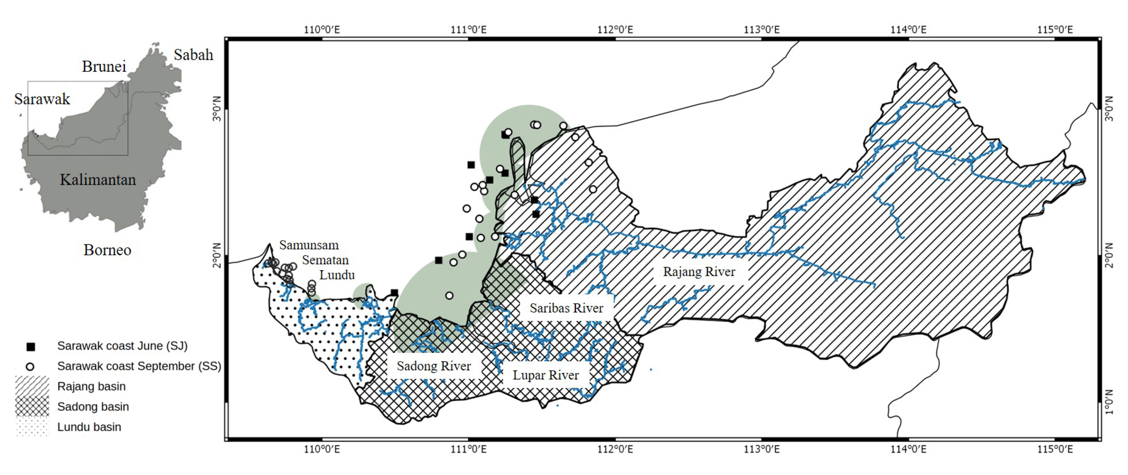
2.1. Study Area
2.2. Water Sampling
2.3. In-Situ Optical Measurements
2.4. Algorithm Development, Validation, and Accuracy Assessment
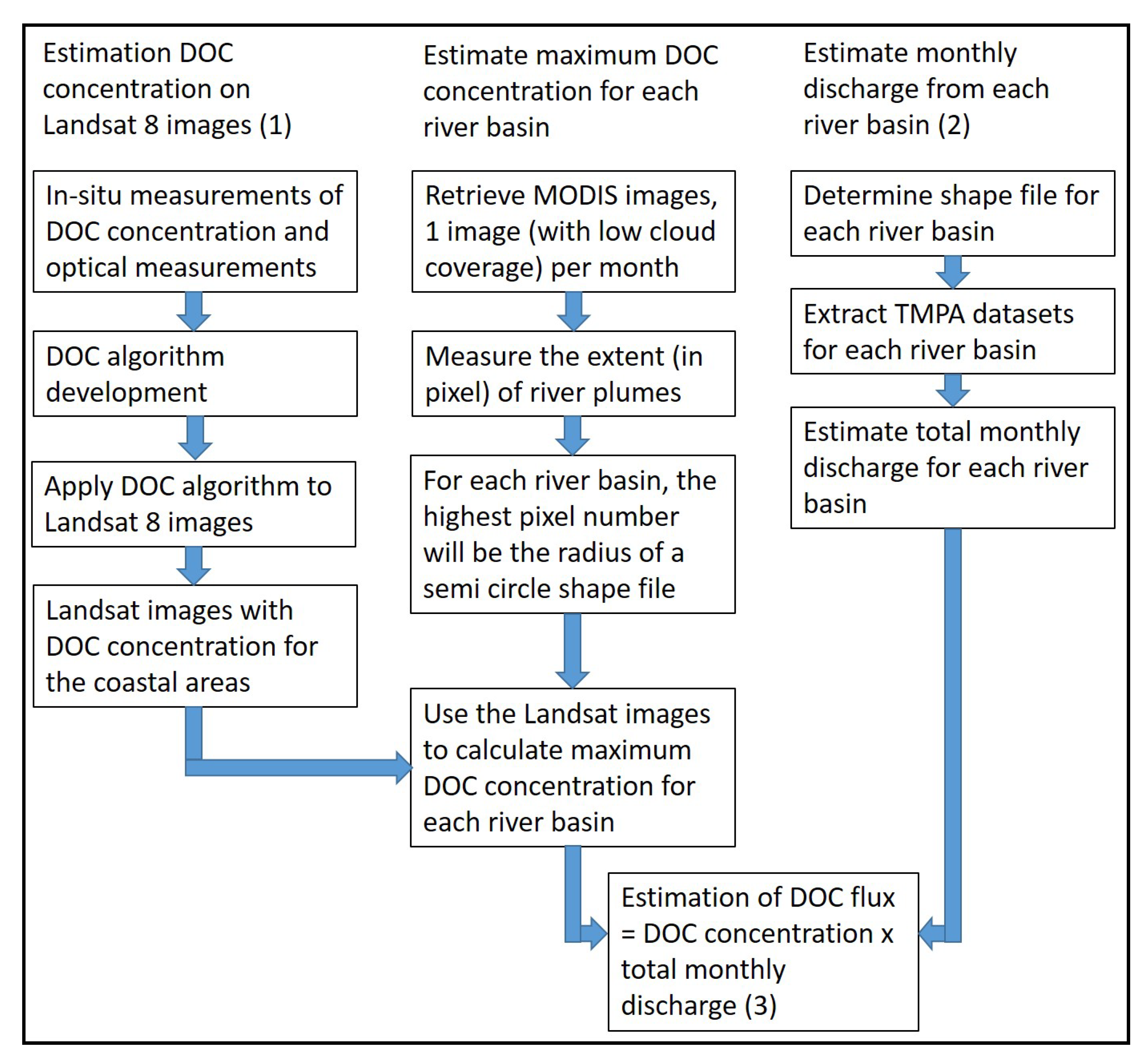
2.5. Landsat-8 Image Acquisition and Estimation of DOC Concentration of Coastal Water
2.6. Estimate Maximum DOC Concentration for Each River Basin
2.7. TMPA Data Acquisition and Estimation of Water Discharge
2.8. DOC Flux Demonstration
3. Results
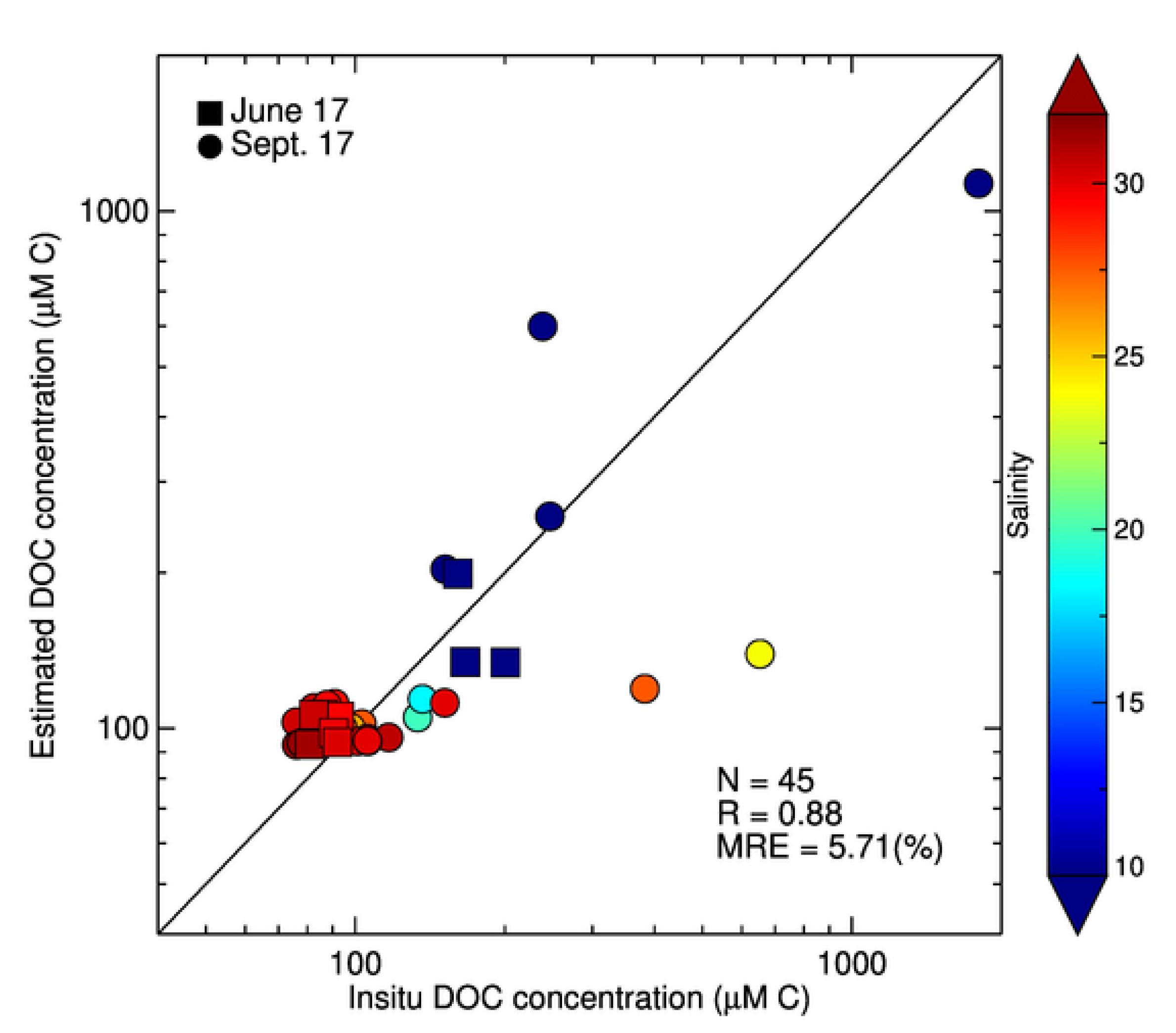
3.1. Determination of the Best DOC Algorithm for Landsat-8 in Sarawak Waters
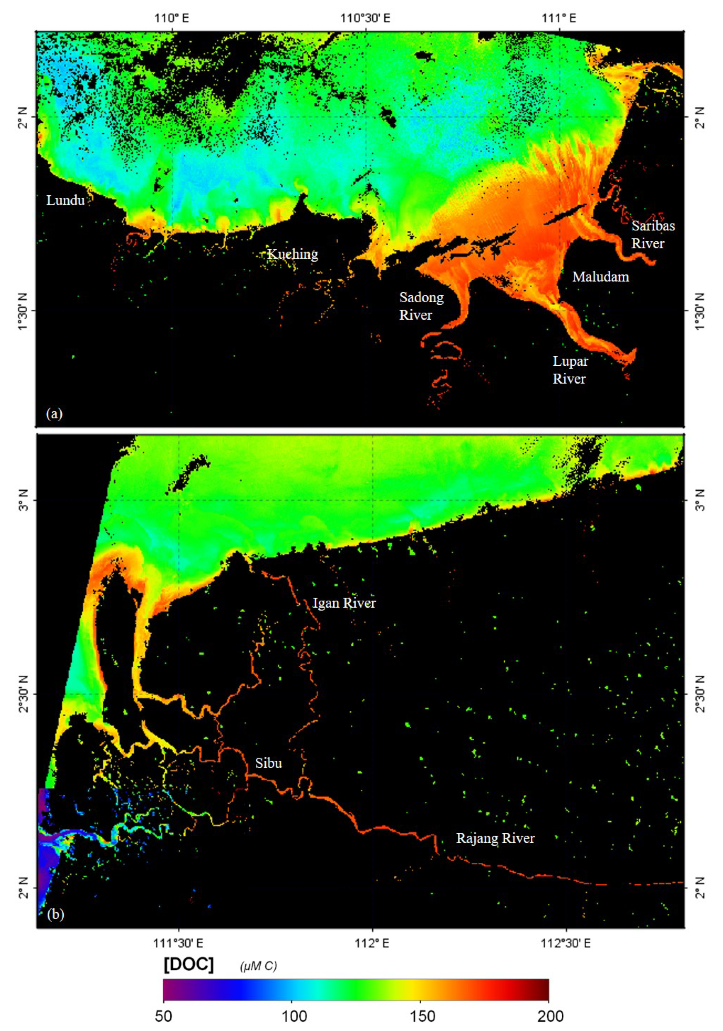
3.2. Applying the Algorithm to Landsat-8 Imagery
3.3. Calculation of Precipitation and Discharge from TMPA Dataset
4. Discussions
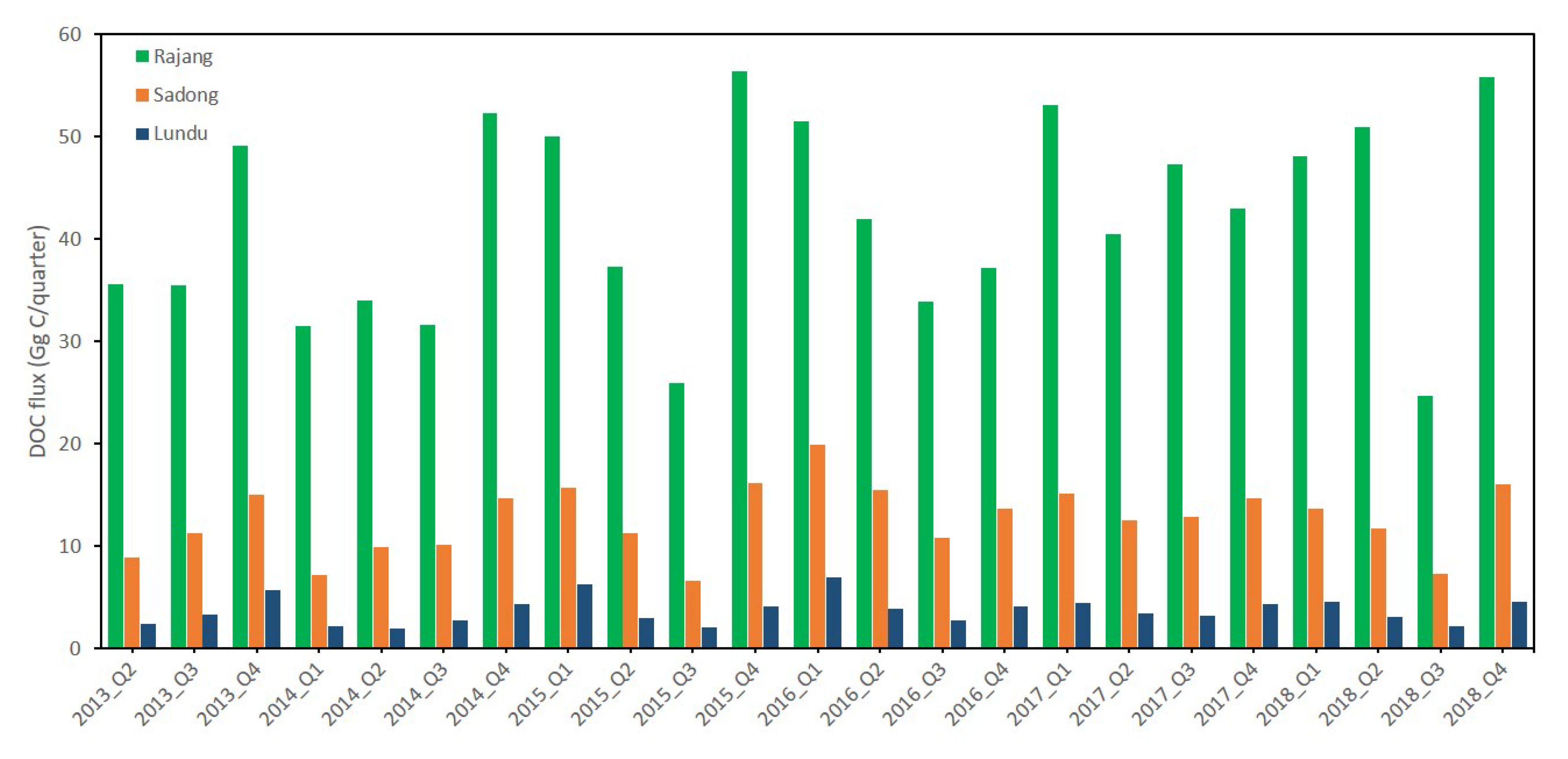
4.1. DOC Flux Variability in Sarawak Coastal Waters
4.2. Uncertainties and Limitations
5. Conclusions
Supplementary Materials
Author Contributions
Funding
Acknowledgments
Conflicts of Interest
References
- Hansell, D.A.; Carlson, C.A. Deep-ocean gradients in the concentration of dissolved organic carbon. Nature 1998, 395, 263–266. [Google Scholar] [CrossRef]
- Dai, M.; Yin, Z.; Meng, F.; Liu, Q.; Cai, W.J. Spatial distribution of riverine DOC inputs to the ocean: An updated global synthesis. Curr. Opin. Environ. Sustain. 2012, 4, 170–178. [Google Scholar] [CrossRef]
- Huang, T.H.; Chen, C.T.A.A.; Tseng, H.C.; Lou, J.Y.; Wang, S.L.; Yang, L.; Kandasamy, S.; Gao, X.; Wang, J.T.; Aldrian, E.; et al. Riverine carbon fluxes to the South China Sea. J. Geophys. Res. Biogeosci. 2017, 122, 1239–1259. [Google Scholar] [CrossRef]
- Page, S.E.; Rieley, J.O.; Banks, C.J. Global and regional importance of the tropical peatland carbon pool. Glob. Chang. Biol. 2011, 17, 798–818. [Google Scholar] [CrossRef] [Green Version]
- Wit, F.; Müller, D.; Baum, A.; Warneke, T.; Pranowo, W.S.; Müller, M.; Rixen, T. The impact of disturbed peatlands on river outgassing in Southeast Asia. Nat. Commun. 2015, 6, 1–9. [Google Scholar] [CrossRef] [Green Version]
- Moore, S.; Gauci, V.; Evans, C.D.; Page, S.E. Fluvial organic carbon losses from a Bornean blackwater river. Biogeosciences 2011, 8, 901–909. [Google Scholar] [CrossRef] [Green Version]
- Ward, N.D.; Bianchi, T.S.; Medeiros, P.M.; Seidel, M.; Richey, J.E.; Keil, R.G.; Sawakuchi, H.O. Where Carbon Goes When Water Flows: Carbon Cycling across the Aquatic Continuum. Front. Mar. Sci. 2017, 4, 1–27. [Google Scholar] [CrossRef] [Green Version]
- Petihakis, G.; Perivoliotis, L.; Korres, G.; Ballas, D.; Frangoulis, C.; Pagonis, P.; Ntoumas, M.; Pettas, M.; Chalkiopoulos, A.; Sotiropoulou, M.; et al. An integrated open-coastal biogeochemistry, ecosystem and biodiversity observatory of the eastern Mediterranean—The Cretan Sea component of the POSEIDON system. Ocean Sci. 2018, 14, 1223–1245. [Google Scholar] [CrossRef] [Green Version]
- Palmer, S.C.J.; Kutser, T.; Hunter, P.D. Remote sensing of inland waters: Challenges, progress and future directions. Remote Sens. Environ. 2015, 157. [Google Scholar] [CrossRef] [Green Version]
- Cardille, J.A.; Leguet, J.B.; Giorgio, P.D. Remote sensing of lake CDOM using noncontemporaneous field data. Can. J. Remote Sens. 2013, 39, 118–126. [Google Scholar] [CrossRef]
- Zhu, W.; Yu, Q. Inversion of chromophoric dissolved organic matter from EO-1 Hyperion imagery for turbid estuarine and coastal waters. IEEE Trans. Geosci. Remote Sens. 2013, 51, 3286–3298. [Google Scholar] [CrossRef]
- Cao, F.; Miller, W.L. A new algorithm to retrieve chromophoric dissolved organic matter (CDOM) absorption spectra in the UV from ocean color. J. Geophys. Res. Oceans 2014, 120, 496–516. [Google Scholar] [CrossRef]
- Brezonik, P.L.; Olmanson, L.G.; Finlay, J.C.; Bauer, M.E. Factors affecting the measuement of CDOM by remote sensing of optically complex inland waters. Remote Sens. Environ. 2014, 157, 199–215. [Google Scholar] [CrossRef]
- Joshi, I.; D’Sa, J. Seasonal variation of colored dissolved organic matter in Baratarian Bay, Louisiana, using combined Landsat and field data. Remote Sens. 2015, 7, 12478–12502. [Google Scholar] [CrossRef] [Green Version]
- Cao, F.; Tzortziou, M.; Hu, C.; Mannino, A.; Fichot, C.G.; Del Vecchio, R.; Najjar, R.G.; Novak, M. Remote sensing retrievals of colored dissolved organic matter and dissolved organic carbon dynamics in North American estuaries and their margins. Remote Sens. Environ. 2018, 205, 151–165. [Google Scholar] [CrossRef]
- Chen, J.; Zhu, W.N.; Tian, Y.Q.; Yu, Q. Estimation of Colored Dissolved Organic Matter from Landsat-8 Imagery for Complex Inland Water: Case Study of Lake Huron. IEEE Trans. Geosci. Remote Sens. 2017, 55, 2201–2212. [Google Scholar] [CrossRef]
- Li, M.; Peng, C.; Zhou, X.; Yang, Y.; Guo, Y.; Shi, G.; Zhu, Q. Modeling Global Riverine DOC Flux Dynamics From 1951 to 2015. J. Adv. Model. Earth Syst. 2019, 11, 514–530. [Google Scholar] [CrossRef] [Green Version]
- Xu, J.; Fang, C.; Gao, D.; Zhang, H.; Gao, H.; Xu, Z.; Wang, Y. Optical models for remote sensing of chromophoric dissolved organic matter (CDOM) absorption in Poyang Lake. ISPRS J. Photogramm. Remote Sens. 2018, 142, 124–136. [Google Scholar] [CrossRef]
- Cherukuru, N.; Ford, P.W.; Matear, R.J.; Oubelkheir, K.; Clementson, L.A.; Suber, K.; Steven, A.D.L. Estimating dissolved organic carbon concentration in turbid coastal waters using optical remote sensing observations. Int. J. Appl. Earth Observ. Geoinf. 2016, 52, 149–154. [Google Scholar] [CrossRef]
- Alcântara, E.; Bernardo, N.; Watanabe, F.; Rodrigues, T.; Rotta, L.; Carmo, A.; Shimabukuro, M.; Gonçalves, S.; Imai, N. Estimating the CDOM absorption coefficient in tropical inland waters using OLI/Landsat-8 images. Remote Sens. Lett. 2016, 7, 661–670. [Google Scholar] [CrossRef]
- Olmanson, L.G.; Brezonic, P.L.; Finlay, J.C.; Bauer, M.E. Comparison of Landsat 8 and Landsat 7 for regional measurements of CDOM and water clarity in lakes. Remote Sens. Environ. 2016, 185, 119–128. [Google Scholar] [CrossRef]
- Slonecker, E.T.; Jones, D.K.; Pellerin, B.A. The new Landsat 8 potential for remote sensing of colored dissolved organic matter (CDOM). Mar. Pollut. Bull. 2016, 107, 518–527. [Google Scholar] [CrossRef] [PubMed]
- Toming, K.; Kutser, T.; Laas, A.; Sepp, M.; Paavel, B.; Noges, T. First experiences in mapping lake water quality parameters with Sentinel-2 MSI Imagery. Remote Sens. 2016, 8, 640. [Google Scholar] [CrossRef] [Green Version]
- Coelho, C.; Heim, B.; Foerster, S.; Brosinsky, A.; Arauho, J.C. In situ and satellite observation of CDOM and chlorophyll-a dynamics in small water surface reservoir in the Brazillian semiaric region. Water 2017, 9, 913. [Google Scholar] [CrossRef] [Green Version]
- Griffin, C.G.; McClelland, J.W.; Frey, K.E.; Fiske, G.; Holmes, R.M. Quantifying CDOM and DOC in major Arctic rivers during ice-free conditions using Landsat TM and ETM+ data. Remote Sens. Environ. 2018, 209, 395–409. [Google Scholar] [CrossRef]
- Herrault, P.A.; Gandois, L.; Gascoin, S.; Tanavaev, N.; Dantec, T.L.; Teisserenc, R. Using high spatio-temporal optical remote sensing to monitor dissolved organic carbon in the Arctic. Remote Sens. 2016, 8, 803. [Google Scholar] [CrossRef] [Green Version]
- Martin, P.; Cherukuru, N.; Tan, A.S.Y.; Sanwlani, N.; Mujahid, A.; Müller, M. Distribution and cycling of terrigenous dissolved organic carbon in peatland-draining rivers and coastal waters of Sarawak, Borneo. Biogeosciences 2018, 15, 6847–6865. [Google Scholar] [CrossRef] [Green Version]
- Tehrani, N.C.; D’Sa, E.J.; Osburn, C.L.; Bianchi, T.S.; Schaeffer, B.A. Chromophoric dissolved organic matter and dissolved organic carbon from Sea-Viewing Wide Field-of-View Sensor (SeaWiFS), Moderate Resolution Imaging Spectroradiometer (MODIS) and MERIS Sensors: Case study for the northern Gulf of Mexico. Remote Sens. 2013, 5, 1439–1464. [Google Scholar] [CrossRef] [Green Version]
- Vantrepotte, V.; Danhiez, F.-P.; Loisel, H.; Ouillon, S.; Mériaux, X.; Cauvin, A.; Dessailly, D. CDOM-DOC relationship in contrasted coastal waters: Implication for DOC retrieval from ocean color remote sensing observation. Opt. Express 2015, 23, 33. [Google Scholar] [CrossRef]
- Meng, J.; Li, L.; Hao, Z.; Wang, J. Suitability of TRMM satellite rainfall in driving a distributed hydrological model in the source region of Yellow River. J. Hydrol. 2014, 509, 320–332. [Google Scholar] [CrossRef]
- Worqlul, A.W.; Yen, H.; Collick, A.S.; Tilahun, S.A.; Langan, S.; Steenhuis, T.S. Evaluation of CFSR, TMPA 3B42 and ground-based rainfall data as input for hydrological models-scarce region: The upper Blue Nile. Catena 2017, 152, 242–251. [Google Scholar] [CrossRef]
- Zhao, Y.; Xie, Q.; Lu, Y.; Hu, B. Hydrologic evaluation of TRMM multisatellite precipitation analysis for Nanliu River basin in humid southwestern China. Sci. Rep. 2017, 7, 2470. [Google Scholar] [CrossRef] [PubMed] [Green Version]
- Kummerow, C.; Barnes, W.; Kozu, T.; Shiue, J.; Simpson, J. The Tropical Rainfall Measuring Mission (TRMM) sensor package. J. Atmos. Ocean. Technol. 1998, 15, 809–817. [Google Scholar] [CrossRef]
- Jiang, S.; Zhang, Z.; Huang, Y.; Chen, X.; Chen, S. Evaluating the TRMM Multisatellite Precipitation Analysis for Extreme Precipitation and Streamflow in Ganjiang River Basin, China. Adv. Meteorol. 2017. [Google Scholar] [CrossRef]
- Mahmud, M.R.; Numata, S.; Matsuyama, H.; Hosaka, T.; Hashim, M. Assessment of effective seasonal downscaling of TRMM precipitation data in Peninsular Malaysia. Remote Sens. 2015, 7, 4092–4111. [Google Scholar] [CrossRef] [Green Version]
- Tan, M.L.; Duan, Z. Assessment of GPM and TRMM precipitation products over Singapore. Remote Sens. 2017, 9, 720. [Google Scholar] [CrossRef] [Green Version]
- Takahashi, A.; Kumagai, T.; Kanamori, H.; Fujinami, H.; Hiyama, T.; Hara, M.; Science, E. Impact of tropical deforestation and forest degradation on precipitation over Borneo Island. J. Hydrometeorol. 2017, 18, 2907–2922. [Google Scholar] [CrossRef]
- Sun, C. Riverine influence on ocean color in the equatorial South China Sea. Cont. Shelf Res. 2017, 143, 151–158. [Google Scholar] [CrossRef]
- As-syakur, A.R.; Adnyana, I.W.; Mahendra, M.S.; Arthana, I.W.; Merit, I.N.; Kasa, I.W.; Ekayanti, N.W.; Nuarsa, I.W.; Sunarta, I.N. Observation of spatial patterns on the rainfall response to ENSO and IOD over Indonesia using TRMM multisatellite Precipitation Analysis (TMPA). Int. J. Climatol. 2014, 34, 3825–3839. [Google Scholar] [CrossRef]
- Hidayat, H.; Teuling, A.J.; Vermeulen, B.; Taufik, M.; Kastner, K.; Geertsema, T.J.; Bol, D.C.C.; Hoekman, D.H.; Haryani, G.S.; Van Lanen, H.A.J.; et al. Hydrology of inland tropical lowland: The kapuas and Mahakam wetlands. Hydrol. Earth Syst. Sci. 2017, 21, 2579–2594. [Google Scholar] [CrossRef] [Green Version]
- Barsi, J.A.; Lee, K.; Kvaran, G.; Markham, B.L.; Pedelty, J.A.; Imager, L.; Barsi, J.A.; Lee, K.; Kvaran, G.; Markham, B.L.; et al. The spectral response of the Landsat-8 operational land imager. Remote Sens. 2014, 6, 10232–10251. [Google Scholar] [CrossRef] [Green Version]
- Kutser, T.; Casal Pascual, G.; Barbosa, C.; Paavel, B.; Ferreira, R.; Carvalho, L.; Toming, K. Mapping inland water carbon content with Landsat 8 data. Int. J. Remote Sens. 2016, 37, 2950–2961. [Google Scholar] [CrossRef]
- Kuhn, M. Building predictive models in R using the caret package. J. Stat. Softw. 2008, 28, 1–26. [Google Scholar] [CrossRef] [Green Version]
- Bates, D.M.; Chamber, J.M. Statistical Model in S (Nonlinear Models); Chapman and Hall: London, UK, 1992. [Google Scholar]
- Seegers, B.N.; Stumpf, R.P.; Schaeffer, B.A.; Loftin, K.A.; Werdell, P.J. Performance metrics for the assessment of satellite data products: An ocean color case study. Opt. Express 2018, 26, 7404. [Google Scholar] [CrossRef] [Green Version]
- Vanhellemont, Q. Adaptation of the dark spectrum fitting atmospheric correction for aquatic applications of the Landsat and Sentinel-2 archives. Remote Sens. Environ. 2019, 225, 175–192. [Google Scholar] [CrossRef]
- Whitmore, T. Tropical Rain Forests of the Far East, 2nd ed.; Oxford University Press: Oxford, UK, 1984. [Google Scholar] [CrossRef]
- Müller, D.; Warneke, T.; Rixen, T.; Müller, M.; Mujahid, A.; Bange, H.W.; Notholt, J. Fate of terrestrial organic carbon and associated CO2 and CO emissions from two Southeast Asian estuaries. Biogeosciences 2016, 13, 691–705. [Google Scholar] [CrossRef] [Green Version]
- Cao, Y.; Zhang, W.; Wang, W. Evaluation of TRMM 3B43 data over the Yangtze River Delta of China. Sci. Rep. 2018, 8, 1–12. [Google Scholar] [CrossRef] [PubMed] [Green Version]
- Staub, J.R.; Among, H.L.; Gastaldo, R.A. Seasonal sediment transport and deposition in the Rajang River delta, Sarawak, East Malaysia. Sediment. Geol. 2000, 133, 249–264. [Google Scholar] [CrossRef] [Green Version]
- Müller-Dum, D.; Warneke, T.; Rixen, T.; Müller, M.; Baum, A.; Christodoulou, A.; Oakes, J.; Eyre, B.D.; Notholt, J. Impact of peatlands on carbon dioxide emissions from the Rajang River and Estuary, Malaysia. Biogeosciences 2019, 16, 17–32. [Google Scholar] [CrossRef] [Green Version]
- Bange, H.; Hock, S.C.; Bastian, D.; Kallert, J.; Kock, A.; Mujahid, A.; Müller, M. Nitrous oxide (N2O) and methane (CH4) in rivers and estuaries of northwestern borneo. Biogeosciences 2019, 16, 4321–4335. [Google Scholar] [CrossRef] [Green Version]
- Czapla-Myers, J.; McCorkel, J.; Anderson, N.; Thome, K.; Biggar, S.; Helder, D.; Aaron, D.; Leigh, L.; Mishra, N. The ground-based absolute radiometric calibration of Landsat 8 OLI. Remote Sens. 2015, 7, 600–626. [Google Scholar] [CrossRef] [Green Version]
| Parameter | SJ (June 2017) | SS (September 2017) |
|---|---|---|
| Stations, n | 10 | 35 |
| Depth (m) | 1.0–31.7 (12.4 ± 11.6) | 3.0–34.3 (13.5 ± 9.3) |
| Temperature (C) | 27.2–31.2 (29.5 ± 1.1) | 26.5–31.4 (29.5 ± 1.2) |
| Salinity (psu) | 0.1–32.1 (22.0 ± 13.9) | 0.0–32.6 (26.3 ± 10.2) |
| TSS (mg/L) | 1.1–72.4 (21.0 ± 24.0) | 0.5–335.6 (28.9 ± 72.3) |
| DOC (±M) | 81–200 (115 ± 43) | 76–1799 (179.0 ± 306.8) |
| Model | Function | x | R | RMSE | MRE% | K-Fold Validation | |
|---|---|---|---|---|---|---|---|
| Linear | y = (−278.47) · x + 327.13 | B2/B3 | 0.40 | 0.16 | 243.14 | +30.17 | y = (−278.50) · x + 327.10 |
| Linear | y = 4.80 · x + 129.78 | B3/B2 | 0.33 | 0.11 | 250.12 | +41.19 | y = 4.80 · x + 129.78 |
| Linear | y = (−39.00) · x + 287.52 | B3/B4 | 0.34 | 0.12 | 248.91 | +37.37 | y = (−39.00) · x + 287.50 |
| Linear | y = 117.79 · x + 45.96 | B4/B3 | 0.78 | 0.60 | 166.80 | +9.58 | y = 117.79 · x + 45.96 |
| Linear | y = (-23.02) · x + 225.79 | B2/B4 | 0.26 | 0.066 | 255.87 | −43.64 | y = (−23.02) · x + 225.80 |
| Linear | y = 0.83 · x + 137.71 | B4/B2 | 0.40 | 0.16 | 243.13 | −40.59 | y = 0.83 · x + 137.70 |
| Power | y | B2/B3 | 0.49 | 0.24 | 236.39 | +6.24 | |
| Power | y | B3/B2 | 0.49 | 0.24 | 236.39 | +6.24 | |
| Power | y | B3/B4 | 0.67 | 0.45 | 224.18 | +6.90 | |
| Power | y | B4/B3 | 0.67 | 0.45 | 224.18 | +6.90 | |
| Power | y | B2/B4 | 0.58 | 0.34 | 228.77 | −6.33 | |
| Power | y | B4/B2 | 0.58 | 0.34 | 228.77 | −6.33 | |
| Exp. | y | B2/B3 | 0.46 | 0.22 | 249.67 | +7.83 | |
| Exp. | y | B3/B2 | 0.18 | 0.033 | 265.68 | +10.13 | |
| Exp. | y | B3/B4 | 0.39 | 0.15 | 255.97 | +9.65 | |
| Exp. | y | B4/B3 | 0.88 | 0.77 | 143.54 | +5.71 | |
| Exp. | y | B2/B4 | 0.29 | 0.084 | 261.59 | +10.32 | |
| Exp. | y | B4/B2 | 0.24 | 0.056 | 260.75 | +10.64 | |
| Log. | y | B2/B3 | 0.52 | 0.27 | 225.66 | +18.37 | |
| Log. | y | B3/B2 | 0.52 | 0.27 | 225.66 | +18.37 | |
| Log. | y | B3/B4 | 0.56 | 0.32 | 218.80 | +18.26 | |
| Log. | y | B4/B3 | 0.56 | 0.32 | 218.80 | +18.26 | |
| Log. | y | B2/B4 | 0.55 | 0.30 | 221.26 | +17.30 | |
| Log. | y | B4/B2 | 0.55 | 0.30 | 221.26 | +17.30 | |
| Boot. | y | B4/B3 | 0.88 | 0.77 | 140.11 | +6.35 |
| March 2017 Data Set | Match Up with Landsat-8 | |||||||||
|---|---|---|---|---|---|---|---|---|---|---|
| River | Sta | Lat | Long | Time | DOC M | Lat | Long | D, km | DOC* M | MRE % |
| Rajang | 7 | 2.3425 | 111.3662 | 9:46 | 162.9 | 2.3367 | 111.3827 | 1.94 | 119.8 | −26.5 |
| Rajang | 8 | 2.3525 | 111.3536 | 10:43 | 155.0 | |||||
| Rajang | 11 | 2.4335 | 111.2818 | 12:50 | 152.5 | 2.4357 | 111.2834 | 0.30 | 119.2 | −21.9 |
| Rajang | 12 | 2.4576 | 111.2442 | 13:49 | 139.6 | 2.4287 | 111.2413 | 3.23 | 111.7 | −20.0 |
| Rajang | 13 | 2.4792 | 111.1311 | 15:30 | 96.2 | |||||
| Rajang | 14 | 2.1546 | 111.4021 | 18:24 | 94.6 | |||||
© 2020 by the authors. Licensee MDPI, Basel, Switzerland. This article is an open access article distributed under the terms and conditions of the Creative Commons Attribution (CC BY) license (http://creativecommons.org/licenses/by/4.0/).
Share and Cite
ChunHock, S.; Cherukuru, N.; Mujahid, A.; Martin, P.; Sanwlani, N.; Warneke, T.; Rixen, T.; Notholt, J.; Müller, M. A New Remote Sensing Method to Estimate River to Ocean DOC Flux in Peatland Dominated Sarawak Coastal Regions, Borneo. Remote Sens. 2020, 12, 3380. https://doi.org/10.3390/rs12203380
ChunHock S, Cherukuru N, Mujahid A, Martin P, Sanwlani N, Warneke T, Rixen T, Notholt J, Müller M. A New Remote Sensing Method to Estimate River to Ocean DOC Flux in Peatland Dominated Sarawak Coastal Regions, Borneo. Remote Sensing. 2020; 12(20):3380. https://doi.org/10.3390/rs12203380
Chicago/Turabian StyleChunHock, Sim, Nagur Cherukuru, Aazani Mujahid, Patrick Martin, Nivedita Sanwlani, Thorsten Warneke, Tim Rixen, Justus Notholt, and Moritz Müller. 2020. "A New Remote Sensing Method to Estimate River to Ocean DOC Flux in Peatland Dominated Sarawak Coastal Regions, Borneo" Remote Sensing 12, no. 20: 3380. https://doi.org/10.3390/rs12203380
APA StyleChunHock, S., Cherukuru, N., Mujahid, A., Martin, P., Sanwlani, N., Warneke, T., Rixen, T., Notholt, J., & Müller, M. (2020). A New Remote Sensing Method to Estimate River to Ocean DOC Flux in Peatland Dominated Sarawak Coastal Regions, Borneo. Remote Sensing, 12(20), 3380. https://doi.org/10.3390/rs12203380


