Using the Digital Elevation Model (DEM) to Improve the Spatial Coverage of the MODIS Based Reservoir Monitoring Network in South Asia


Abstract
:
1. Introduction
2. Data
2.1. Remote Sensing Data
2.2. Data for Validations
3. Reservoir Selection and Methodology
3.1. Reservoir Selection
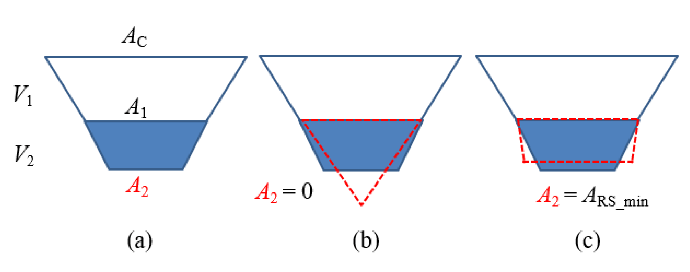
3.2. Methodology for Reservoir Storage Estimation
3.2.1. Surface Area Estimation
3.2.2. Area-Elevation (A-H) Relationship Development
3.2.3. Storage Estimation
4. Results
4.1. Validation Results
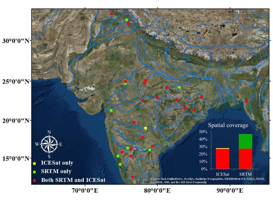
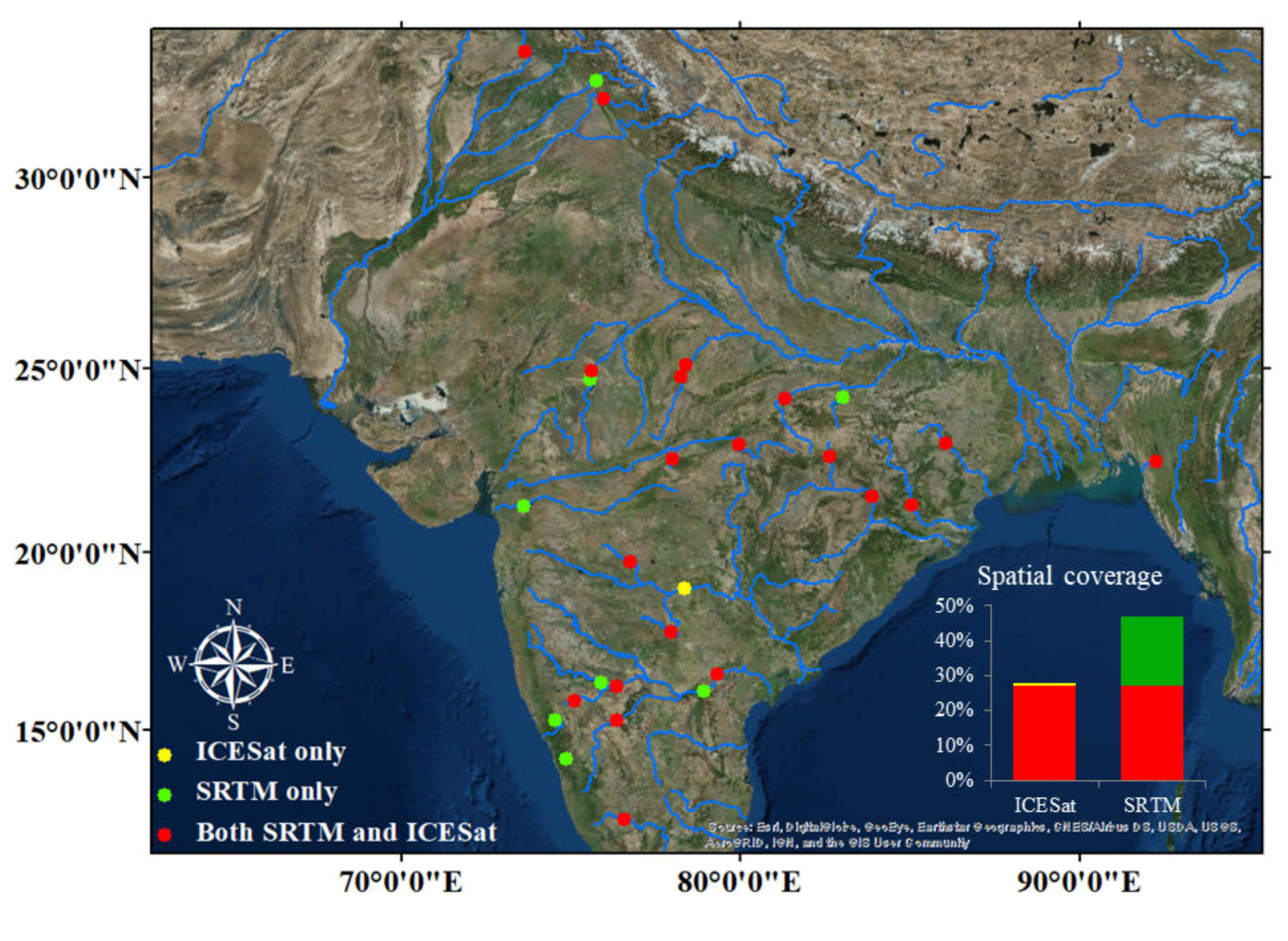
4.2. Spatial Coverage of the Reservoir Storage Dataset
4.3. Uncertainty Analysis
5. Conclusions
Author Contributions
Funding
Conflicts of Interest
References
- Bai, T.; Wu, L.; Chang, J.-X.; Huang, Q. Multi-objective optimal operation model of cascade reservoirs and its application on water and sediment regulation. Water Resour. Manag. 2015, 29, 2751–2770. [Google Scholar] [CrossRef]
- Haddeland, I.; Heinke, J.; Biemans, H.; Eisner, S.; Flörke, M.; Hanasaki, N.; Konzmann, M.; Ludwig, F.; Masaki, Y.; Schewe, J. Global water resources affected by human interventions and climate change. Proc. Natl. Acad. Sci. USA 2014, 111, 3251–3256. [Google Scholar] [CrossRef] [PubMed] [Green Version]
- Zhao, G.; Gao, H.; Naz, B.S.; Kao, S.-C.; Voisin, N. Integrating a reservoir regulation scheme into a spatially distributed hydrological model. Adv. Water Resour. 2016, 98, 16–31. [Google Scholar] [CrossRef] [Green Version]
- Li, Y.; Gao, H.; Jasinski, M.F.; Zhang, S.; Stoll, J.D. Deriving High-Resolution Reservoir Bathymetry From ICESat-2 Prototype Photon-Counting Lidar and Landsat Imagery. IEEE Trans. Geosci. Remote Sens. 2019, 57, 7883–7893. [Google Scholar] [CrossRef]
- Lauri, H.; de Moel, H.; Ward, P.; Räsänen, T.; Keskinen, M.; Kummu, M. Future changes in Mekong River hydrology: Impact of climate change and reservoir operation on discharge. Hydrol. Earth Syst. Sci. 2012, 16, 4603–4619. [Google Scholar] [CrossRef]
- Le, T.V.H.; Nguyen, H.N.; Wolanski, E.; Tran, T.C.; Haruyama, S. The combined impact on the flooding in Vietnam’s Mekong River delta of local man-made structures, sea level rise, and dams upstream in the river catchment. Estuar. Coast. Shelf Sci. 2007, 71, 110–116. [Google Scholar] [CrossRef]
- Pulwarty, R.S.; Sivakumar, M.V. Information systems in a changing climate: Early warnings and drought risk management. Weather Clim. Extrem. 2014, 3, 14–21. [Google Scholar] [CrossRef] [Green Version]
- Vicente-Serrano, S.M.; Beguería, S.; Gimeno, L.; Eklundh, L.; Giuliani, G.; Weston, D.; El Kenawy, A.; López-Moreno, J.I.; Nieto, R.; Ayenew, T. Challenges for drought mitigation in Africa: The potential use of geospatial data and drought information systems. Appl. Geogr. 2012, 34, 471–486. [Google Scholar] [CrossRef] [Green Version]
- Gao, H.; Birkett, C.; Lettenmaier, D.P. Global monitoring of large reservoir storage from satellite remote sensing. Water Resour. Res. 2012, 48, W09504. [Google Scholar] [CrossRef] [Green Version]
- Lettenmaier, D.P.; Alsdorf, D.; Dozier, J.; Huffman, G.J.; Pan, M.; Wood, E.F. Inroads of remote sensing into hydrologic science during the WRR era. Water Resour. Res. 2015, 51, 7309–7342. [Google Scholar] [CrossRef]
- Rodrigues, L.N.; Sano, E.E.; Steenhuis, T.S.; Passo, D.P. Estimation of small reservoir storage capacities with remote sensing in the Brazilian Savannah Region. Water Resour. Manag. 2012, 26, 873–882. [Google Scholar] [CrossRef]
- Pereira, B.; Medeiros, P.; Francke, T.; Ramalho, G.; Foerster, S.; De Araújo, J.C. Assessment of the geometry and volumes of small surface water reservoirs by remote sensing in a semi-arid region with high reservoir density. Hydrol. Sci. J. 2019, 64, 66–79. [Google Scholar] [CrossRef]
- Zhao, G.; Gao, H. Automatic correction of contaminated images for assessment of reservoir surface area dynamics. Geophys. Res. Lett. 2018, 45, 6092–6099. [Google Scholar] [CrossRef]
- Yao, F.; Wang, J.; Wang, C.; Crétaux, J.-F. Constructing long-term high-frequency time series of global lake and reservoir areas using Landsat imagery. Remote Sens. Environ. 2019, 232, 111210. [Google Scholar] [CrossRef]
- Berry, P.; Garlick, J.; Freeman, J.; Mathers, E. Global inland water monitoring from multi-mission altimetry. Geophys. Res. Lett. 2005, 32. [Google Scholar] [CrossRef]
- Birkett, C.M. Contribution of the TOPEX NASA radar altimeter to the global monitoring of large rivers and wetlands. Water Resour. Res. 1998, 34, 1223–1239. [Google Scholar] [CrossRef]
- Wang, X.; Gong, P.; Zhao, Y.; Xu, Y.; Cheng, X.; Niu, Z.; Luo, Z.; Huang, H.; Sun, F.; Li, X. Water-level changes in China’s large lakes determined from ICESat/GLAS data. Remote Sens. Environ. 2013, 132, 131–144. [Google Scholar] [CrossRef]
- Zhang, G.; Xie, H.; Kang, S.; Yi, D.; Ackley, S.F. Monitoring lake level changes on the Tibetan Plateau using ICESat altimetry data (2003–2009). Remote Sens. Environ. 2011, 115, 1733–1742. [Google Scholar] [CrossRef]
- Zhang, S.; Gao, H. A novel algorithm for monitoring reservoirs under all-weather conditions at a high temporal resolution through passive microwave remote sensing. Geophys. Res. Lett. 2016, 43, 8052–8059. [Google Scholar] [CrossRef]
- Zhang, G.; Chen, W.; Xie, H. Tibetan Plateau’s lake level and volume changes from NASA’s ICESat/ICESat-2 and Landsat missions. Geophys. Res. Lett. 2019, 46, 13107–13118. [Google Scholar] [CrossRef]
- Liebe, J.; Van De Giesen, N.; Andreini, M. Estimation of small reservoir storage capacities in a semi-arid environment: A case study in the Upper East Region of Ghana. Phys. Chem. Earth Parts A/B/C 2005, 30, 448–454. [Google Scholar] [CrossRef]
- Smith, L.C.; Pavelsky, T.M. Remote sensing of volumetric storage changes in lakes. Earth Surf. Processes Landf. 2009, 34, 1353–1358. [Google Scholar] [CrossRef]
- Busker, T.; de Roo, A.; Gelati, E.; Schwatke, C.; Adamovic, M.; Bisselink, B.; Pekel, J.-F.; Cottam, A. A global lake and reservoir volume analysis using a surface water dataset and satellite altimetry. Hydrol. Earth Syst. Sci. 2019, 23, 669–690. [Google Scholar] [CrossRef] [Green Version]
- Gao, H. Satellite remote sensing of large lakes and reservoirs: From elevation and area to storage. Wiley Interdiscip. Rev. Water 2015, 2, 147–157. [Google Scholar] [CrossRef]
- Zhang, S.; Gao, H.; Naz, B.S. Monitoring reservoir storage in South Asia from multisatellite remote sensing. Water Resour. Res. 2014, 50, 8927–8943. [Google Scholar] [CrossRef]
- Bonnema, M.; Hossain, F. Inferring reservoir operating patterns across the M ekong B asin using only space observations. Water Resour. Res. 2017, 53, 3791–3810. [Google Scholar] [CrossRef]
- Tseng, K.-H.; Shum, C.; Kim, J.-W.; Wang, X.; Zhu, K.; Cheng, X. Integrating Landsat imageries and digital elevation models to infer water level change in Hoover Dam. IEEE J. Sel. Top. Appl. Earth Obs. Remote Sens. 2016, 9, 1696–1709. [Google Scholar] [CrossRef]
- Getirana, A.; Jung, H.C.; Tseng, K.-H. Deriving three dimensional reservoir bathymetry from multi-satellite datasets. Remote Sens. Environ. 2018, 217, 366–374. [Google Scholar] [CrossRef]
- Adhikari, P.; Hong, Y.; Douglas, K.R.; Kirschbaum, D.B.; Gourley, J.; Adler, R.; Brakenridge, G.R. A digitized global flood inventory (1998–2008): Compilation and preliminary results. Natl. Hazards 2010, 55, 405–422. [Google Scholar] [CrossRef]
- Hydrology by Altimetry. Available online: http://www.legos.obs-mip.fr/soa/hydrologie/hydroweb/Page_2.html (accessed on 31 December 2019).
- Global Reservoirs and Lakes Monitor. Available online: https://ipad.fas.usda.gov/cropexplorer/global_reservoir/ (accessed on 31 December 2019).
- Goteti, G.; Famiglietti, J.S.; Asante, K. A catchment-based hydrologic and routing modeling system with explicit river channels. J. Geophys. Res. Atmos. 2008, 113. [Google Scholar] [CrossRef] [Green Version]
- Lehner, B.; Grill, G. Global river hydrography and network routing: Baseline data and new approaches to study the world’s large river systems. Hydrol. Processes 2013, 27, 2171–2186. [Google Scholar] [CrossRef]
- Berthier, E.; Arnaud, Y.; Vincent, C.; Remy, F. Biases of SRTM in high-mountain areas: Implications for the monitoring of glacier volume changes. Geophys. Res. Lett. 2006, 33. [Google Scholar] [CrossRef]
- Surazakov, A.B.; Aizen, V.B. Estimating volume change of mountain glaciers using SRTM and map-based topographic data. IEEE Trans. Geosci. Remote Sens. 2006, 44, 2991–2995. [Google Scholar] [CrossRef]
- Papa, F.; Frappart, F.; Güntner, A.; Prigent, C.; Aires, F.; Getirana, A.C.; Maurer, R. Surface freshwater storage and variability in the Amazon basin from multi-satellite observations, 1993–2007. J. Geophys. Res. Atmos. 2013, 118, 11951–11965. [Google Scholar] [CrossRef] [Green Version]
- Rabus, B.; Eineder, M.; Roth, A.; Bamler, R. The shuttle radar topography mission—A new class of digital elevation models acquired by spaceborne radar. ISPRS J. Photogramm. Remote Sens. 2003, 57, 241–262. [Google Scholar] [CrossRef]
- Farr, T.G.; Kobrick, M. Shuttle Radar Topography Mission produces a wealth of data. Eos Trans. Am. Geophys. Union 2000, 81, 583–585. [Google Scholar] [CrossRef]
- U.S. Geological Survey’s Long Term Archive. Available online: https://lta.cr.usgs.gov/SRTM1Arc (accessed on 31 December 2019).
- Indian Central Electricity Authority. Available online: http://www.cea.nic.in (accessed on 30 May 2016).
- Lehner, B.; Liermann, C.R.; Revenga, C.; Vörösmarty, C.; Fekete, B.; Crouzet, P.; Döll, P.; Endejan, M.; Frenken, K.; Magome, J. High-resolution mapping of the world’s reservoirs and dams for sustainable river-flow management. Front. Ecol. Environ. 2011, 9, 494–502. [Google Scholar] [CrossRef] [Green Version]
- Jain, A.K. Data clustering: 50 years beyond K-means. Pattern Recognit. Lett. 2010, 31, 651–666. [Google Scholar] [CrossRef]
- Gao, H.; Zhang, S.; Durand, M.; Lee, H. Satellite remote sensing of lakes and wetlands. In Hydrologic Remote Sensing; CRC Press: Boca Raton, FL, USA, 2016; pp. 57–72. [Google Scholar]
- Rodriguez, E.; Morris, C.S.; Belz, J.E. A global assessment of the SRTM performance. Photogramm. Eng. Remote Sens. 2006, 72, 249–260. [Google Scholar] [CrossRef] [Green Version]
- Jairath, J. Droughts and Integrated Water Resource Management in South Asia: Issues, Alternatives and Futures; SAGE Publications: Southend Oaks, CA, USA, 2008. [Google Scholar]
- India Speed. This Year’s Drought Is Severe, But Not Unprecedented. 2016. Available online: https://everylifecounts.ndtv.com/this-years-drought-is-severe-but-not-unprecedented-2230 (accessed on 31 December 2019).
- Kayani, S.-A. Mangla Dam Raising Project (Pakistan): General Review and Socio-Spatial Impact Assessment; Hal-00719226: Islamabad, Pakistan, 2012. [Google Scholar]
- Sud, S. 38 Reservoirs Down to 30 per Cent Storage. Rediff Business. 2004. Available online: https://www.rediff.com/money/report/water/20040728.htm (accessed on 31 December 2019).
- Bhosale, J. You Don’t Get Water Even If You Are Ready to Pay for It. The Economic Times. 2019. Available online: https://economictimes.indiatimes.com/news/politics-and-nation/you-dont-get-water-even-if-you-are-ready-to-pay-for-it/articleshow/69066949.cms?from=mdr (accessed on 31 December 2019).


| I.D. | Reservoir | Country | Location (°N, °E) | Area at Capacity (km2) | Capacity (km3) | Purpose a | A-H Relationship b |
|---|---|---|---|---|---|---|---|
| 01 | Almatti | India | 16.33, 75.89 | 424 | 2.63 | E | y = 0.026 x + 507.17 |
| 02 | Bango | India | 22.61, 82.60 | 104 | 3.41 | I,E | y = 0.201 x + 332.57 |
| 03 | Bansagar | India | 24.19, 81.29 | 384 | 5.41 | I,E | y = 0.713 x + 315.71 |
| 04 | Bargi | India | 22.95, 79.93 | 268 | 3.92 | I,E | y = 0.104 x + 400.28 |
| 05 | Chandil | India | 22.98, 86.02 | 139 | 1.96 | I,E | y = 0.166 x + 170.15 |
| 06 | Gandhi Sagar | India | 24.71, 75.55 | 578 | 5.60 | E | y= 0.034 x + 378.24 |
| 07 | Hirakud | India | 21.52, 83.85 | 603 | 4.08 | I,E | y = 0.270 x + 174.48 |
| 08 | Karnafuli | Bangladesh | 22.5, 92.23 | 777 | 6.48 | I,E,F | y = 0.024 x + 23.375 |
| 09 | Krisharaja Sagar | India | 12.42, 76.57 | 100 | 1.37 | I,E,W | y = 0.134 x + 736.91 |
| 10 | Linganamakki | India | 14.18, 74.85 | 316 | 4.18 | E | y = 0.079 x + 542.95 |
| 11 | Mangla | Pakistan | 33.13, 73.64 | 251 | 7.30 | I,E,F | y = 0.166 x + 319.61 |
| 12 | Malaprabha | India | 15.82, 75.09 | 130 | 1.07 | I,E | y = 0.136 x + 619.53 |
| 13 | Matatila | India | 25.10, 78.37 | 139 | 1.13 | I,E | y = 0.095 x + 292.84 |
| 14 | N. J. Sagar | India | 16.57, 79.31 | 240 | 6.54 | I,E | y = 0.270 x + 118.8 |
| 15 | Narayanapura | India | 16.22, 76.35 | 102 | 1.07 | I | y = 0.105 x + 482.91 |
| 16 | Pong | India | 31.97, 75.95 | 260 | 6.95 | I,E | y = 0.212 x + 366.98 |
| 17 | Rajghat | India | 24.76, 78.23 | 224 | 2.17 | I,E | y = 0.070 x + 350.35 |
| 18 | Ranjit Sagar | India | 32.44, 75.73 | 56 | 2.20 | E | y = 1.284 x + 441.10 |
| 19 | Rengali | India | 21.28,85.03 | 392 | 3.17 | I | y = 0.070 x + 100.88 |
| 20 | Rihand | India | 24.20, 83.01 | 485 | 5.85 | I,E | y = 0.083 x + 232.99 |
| 21 | R. P. Sagar | India | 24.92, 75.58 | 210 | 1.57 | I,E | y = 0.123 x + 325.49 |
| 22 | Singur | India | 17.75, 77.93 | 129 | 0.85 | W | y = 0.053 x + 517.21 |
| 23 | Srisailam | India | 16.09, 78.90 | 560 | 7.11 | I,E | y = 0.042 x + 254.05 |
| 24 | Supa | India | 15.28, 74.53 | 120 | 4.18 | E | y = 0.460 x + 506.89 |
| 25 | Tawa | India | 22.56, 77.98 | 200 | 2.31 | I | y = 0.117 x + 338.36 |
| 26 | Tungabhadra | India | 15.27, 76.33 | 390 | 3.76 | I,E | y = 0.052 x + 483.92 |
| 27 | Ukai | India | 21.25, 73.59 | 512 | 6.20 | I,E,F | y = 0.042 x + 81.364 |
| 28 | Yeldari | India | 19.72, 76.73 | 82 | 0.93 | I,E | y = 0.223 x + 443.45 |
| ID | Reservoir Name | R2 | Bias (%) | NRMSE (%) |
|---|---|---|---|---|
| 01 | Almatti | 0.84 | 12.40 | 35.87 |
| 05 | Gabdhi Sagar | 0.69 | 6.25 | 15.46 |
| 06 | Hirakud | 0.88 | −11.07 | 18.44 |
| 14 | N. J. Sagar | 0.82 | 2.80 | 27.95 |
| 15 | Pong | 0.88 | 19.25 | 24.52 |
| 17 | Ranjit Sagar | 0.47 | 17.77 | 37.69 |
| 18 | Rengali | 0.79 | −13.43 | 23.81 |
| 19 | Rihand | 0.84 | −16.22 | 28.69 |
| 20 | R. P. Sagar | 0.91 | −1.79 | 15.00 |
| 22 | Srisailam | 0.90 | −31.7 | 32.75 |
| 26 | Ukai | 0.81 | −14.76 | 15.93 |
| Hirakud | N.J. Sagar | Pong | Rengali | R.P. Sagar | ||
|---|---|---|---|---|---|---|
| NRSME (%) | ICESat | 14.58 | 26.50 | 15.21 | 19.69 | 18.18 |
| SRTM | 18.44 | 27.95 | 24.52 | 23.81 | 15.00 | |
| Relative Bias (%) | ICESat | −1.88 | 4.13 | 0.41 | −2.63 | −8.97 |
| SRTM | −11.07 | 2.80 | 19.25 | −13.43 | −1.79 | |
| R2 | ICESat | 0.94 | 0.85 | 0.98 | 0.85 | 0.92 |
| SRTM | 0.88 | 0.82 | 0.88 | 0.79 | 0.91 |
© 2020 by the authors. Licensee MDPI, Basel, Switzerland. This article is an open access article distributed under the terms and conditions of the Creative Commons Attribution (CC BY) license (http://creativecommons.org/licenses/by/4.0/).
Share and Cite
Zhang, S.; Gao, H. Using the Digital Elevation Model (DEM) to Improve the Spatial Coverage of the MODIS Based Reservoir Monitoring Network in South Asia. Remote Sens. 2020, 12, 745. https://doi.org/10.3390/rs12050745
Zhang S, Gao H. Using the Digital Elevation Model (DEM) to Improve the Spatial Coverage of the MODIS Based Reservoir Monitoring Network in South Asia. Remote Sensing. 2020; 12(5):745. https://doi.org/10.3390/rs12050745
Chicago/Turabian StyleZhang, Shuai, and Huilin Gao. 2020. "Using the Digital Elevation Model (DEM) to Improve the Spatial Coverage of the MODIS Based Reservoir Monitoring Network in South Asia" Remote Sensing 12, no. 5: 745. https://doi.org/10.3390/rs12050745
APA StyleZhang, S., & Gao, H. (2020). Using the Digital Elevation Model (DEM) to Improve the Spatial Coverage of the MODIS Based Reservoir Monitoring Network in South Asia. Remote Sensing, 12(5), 745. https://doi.org/10.3390/rs12050745