An Evaluation of Autonomous In Situ Temperature Loggers in a Coastal Region of the Eastern Mediterranean Sea for Use in the Validation of Near-Shore Satellite Sea Surface Temperature Measurements

 ,
,  , and
, and
Abstract
1. Introduction
2. Methods
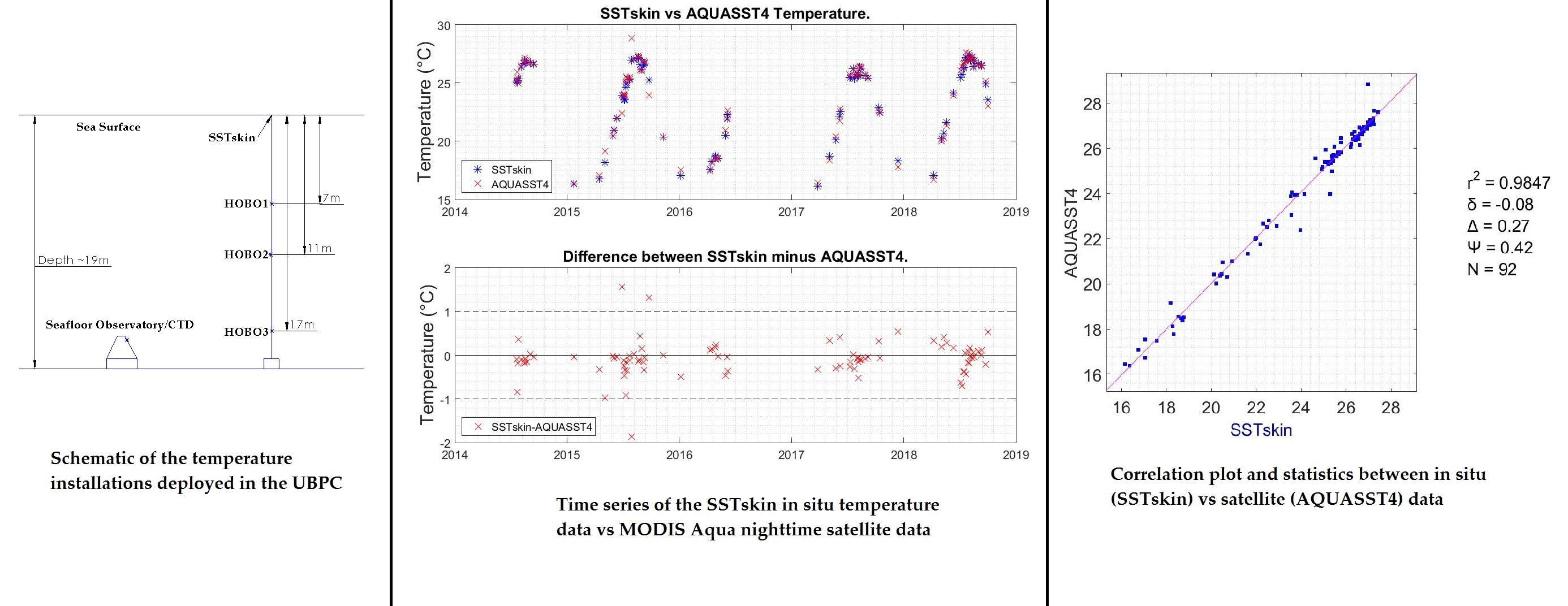
2.1. Study Area
2.2. In Situ Temperature Datasets
2.2.1. Seafloor Temperature Dataset from CTD
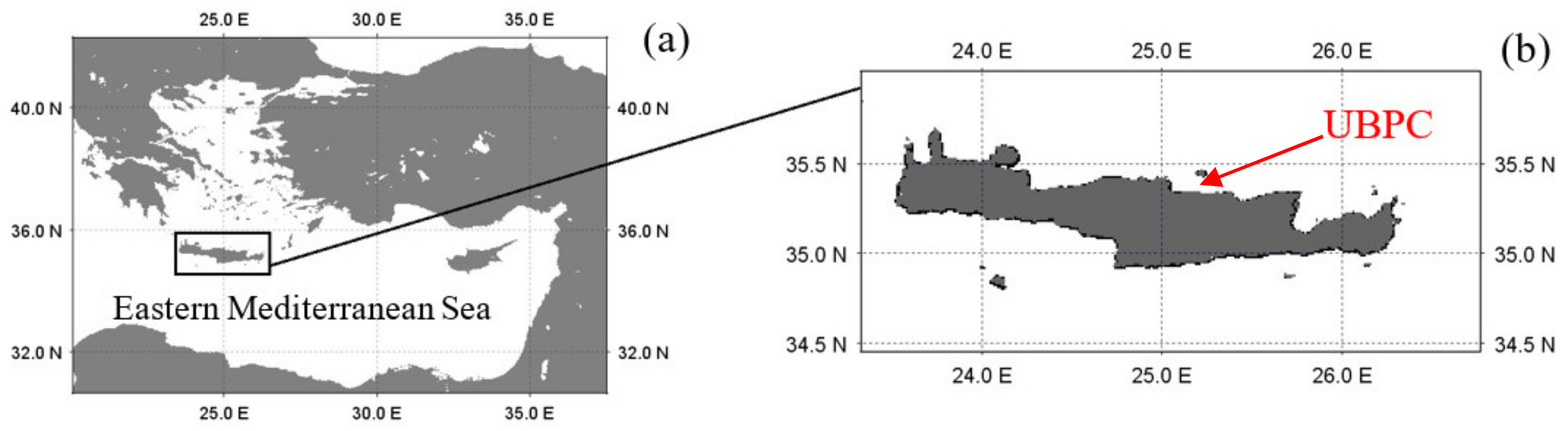
2.2.2. Water Column Temperature Dataset from HOBO Array
2.3. Remote Sensing SST Datasets
2.4. Data Processing and Analysis
3. Results
3.1. Comparison between In Situ Temperature Data
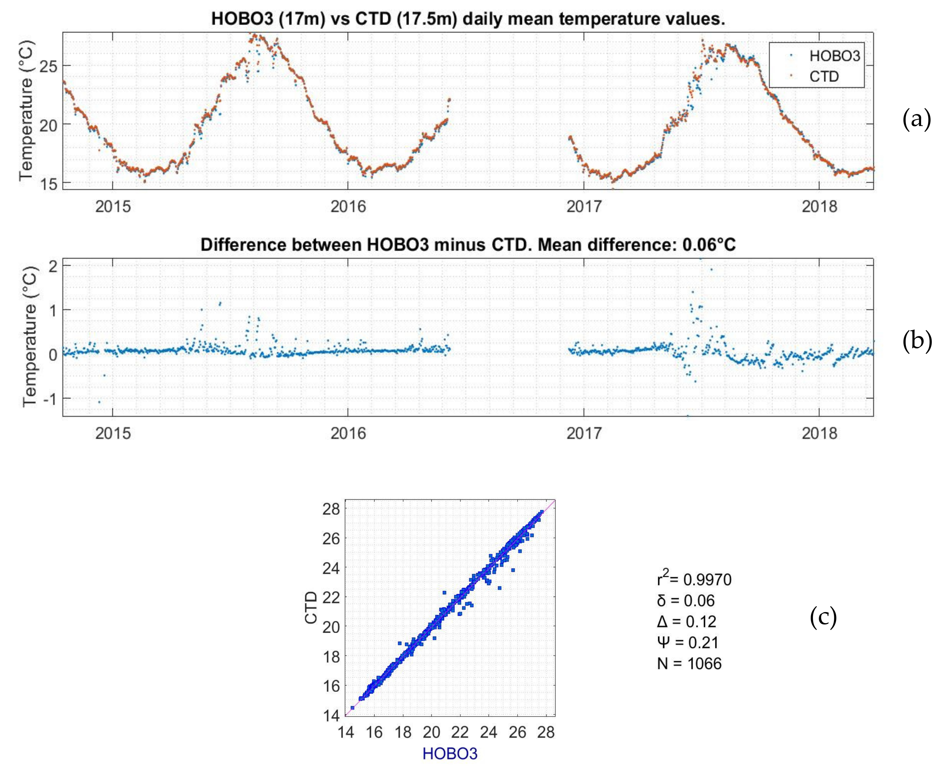
3.1.1. Comparison between the CTD and the HOBO3 Data
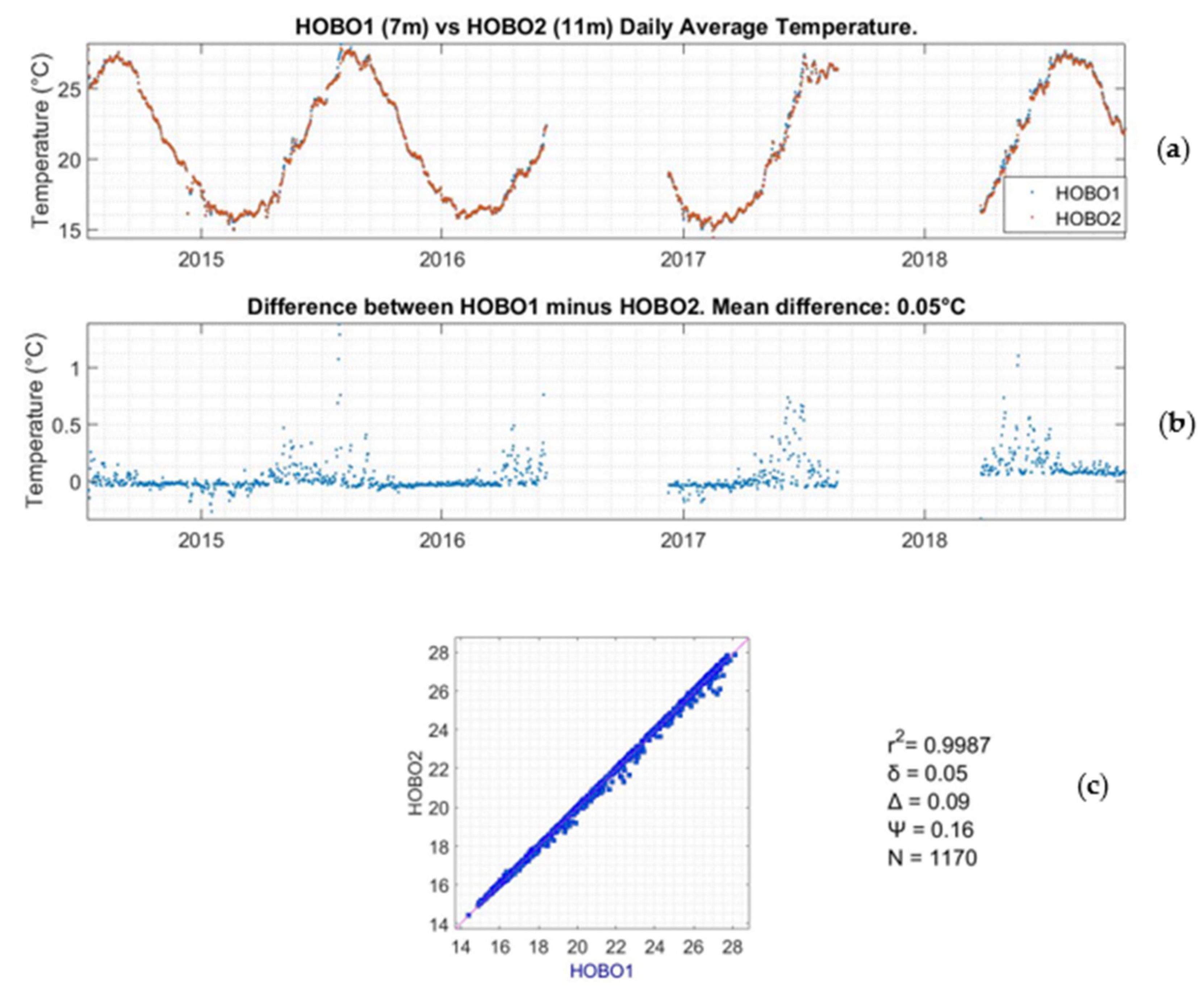
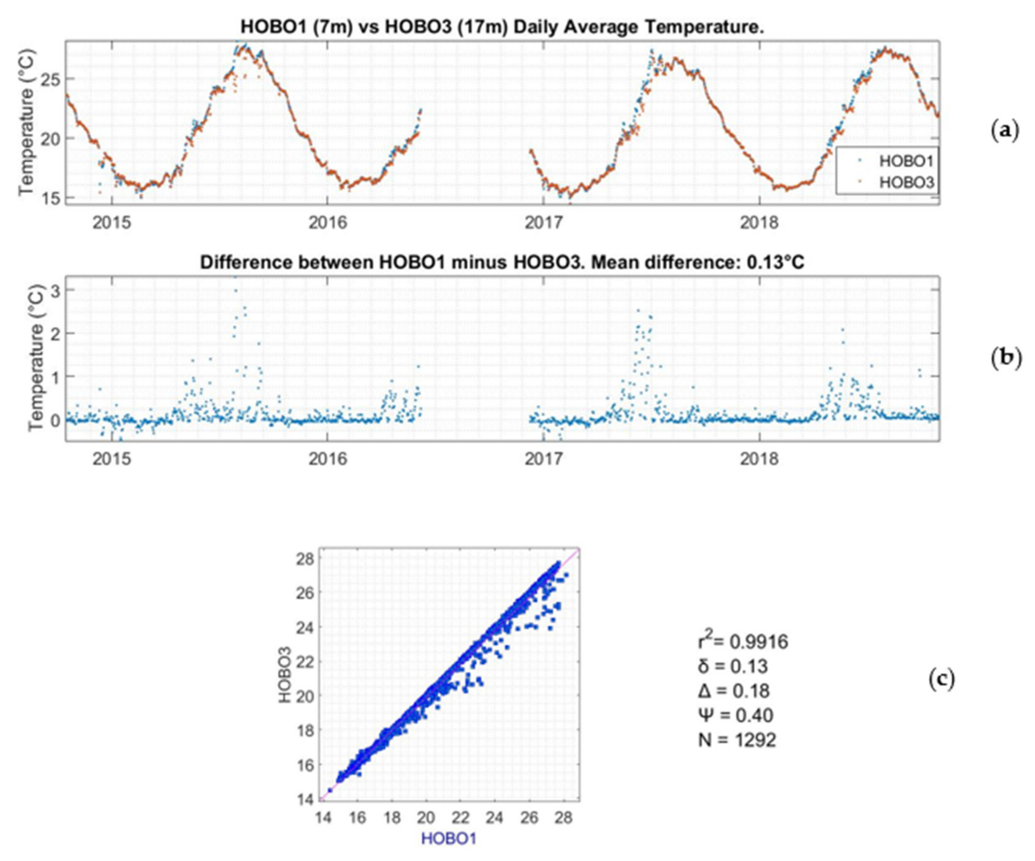
3.1.2. Comparison between the HOBO1, HOBO2, and HOBO3 Data
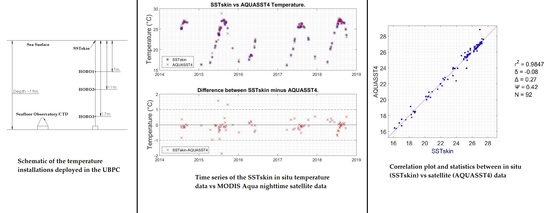
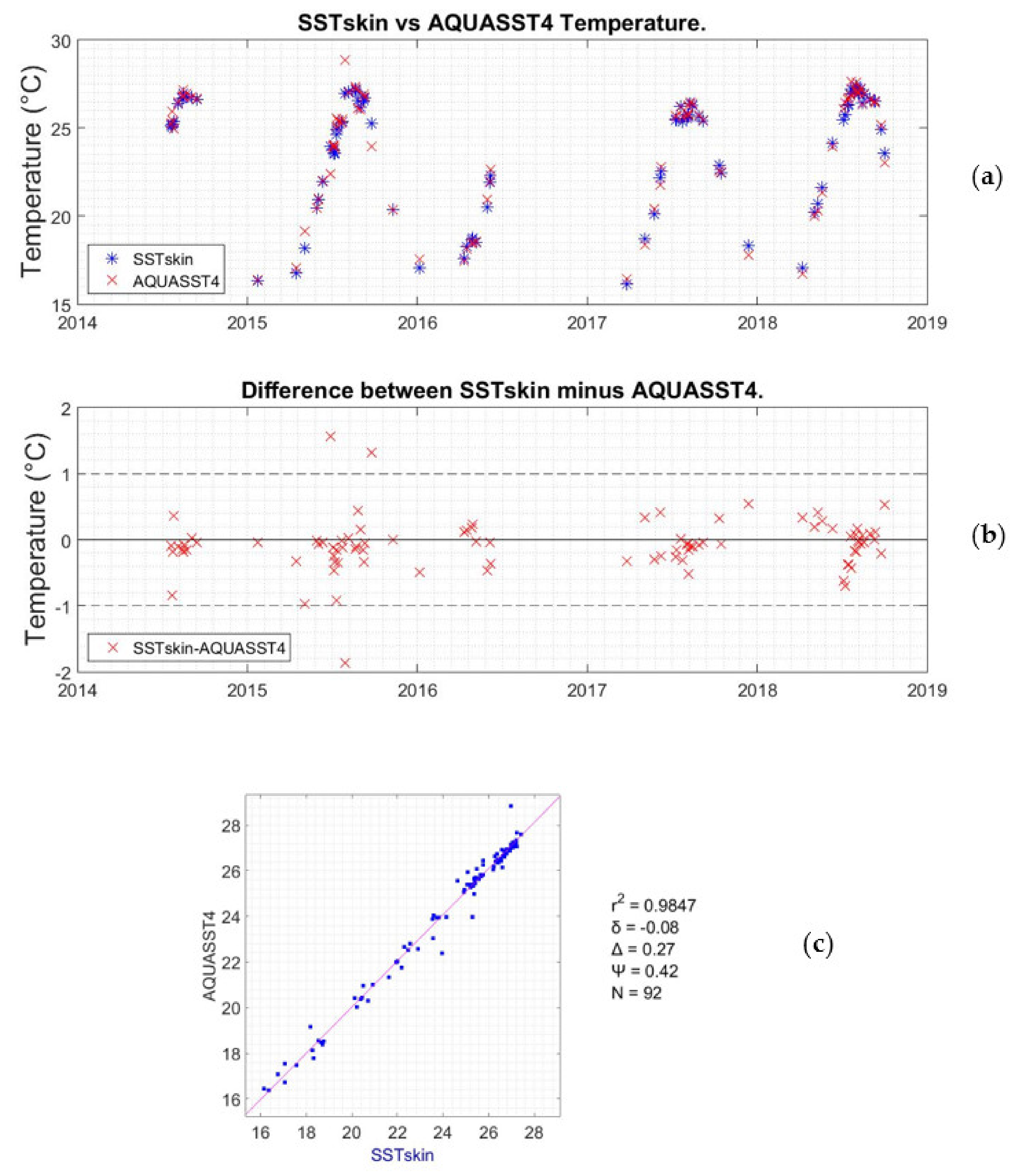
3.2. Comparison between In Situ and Remote Sensing Temperature Data
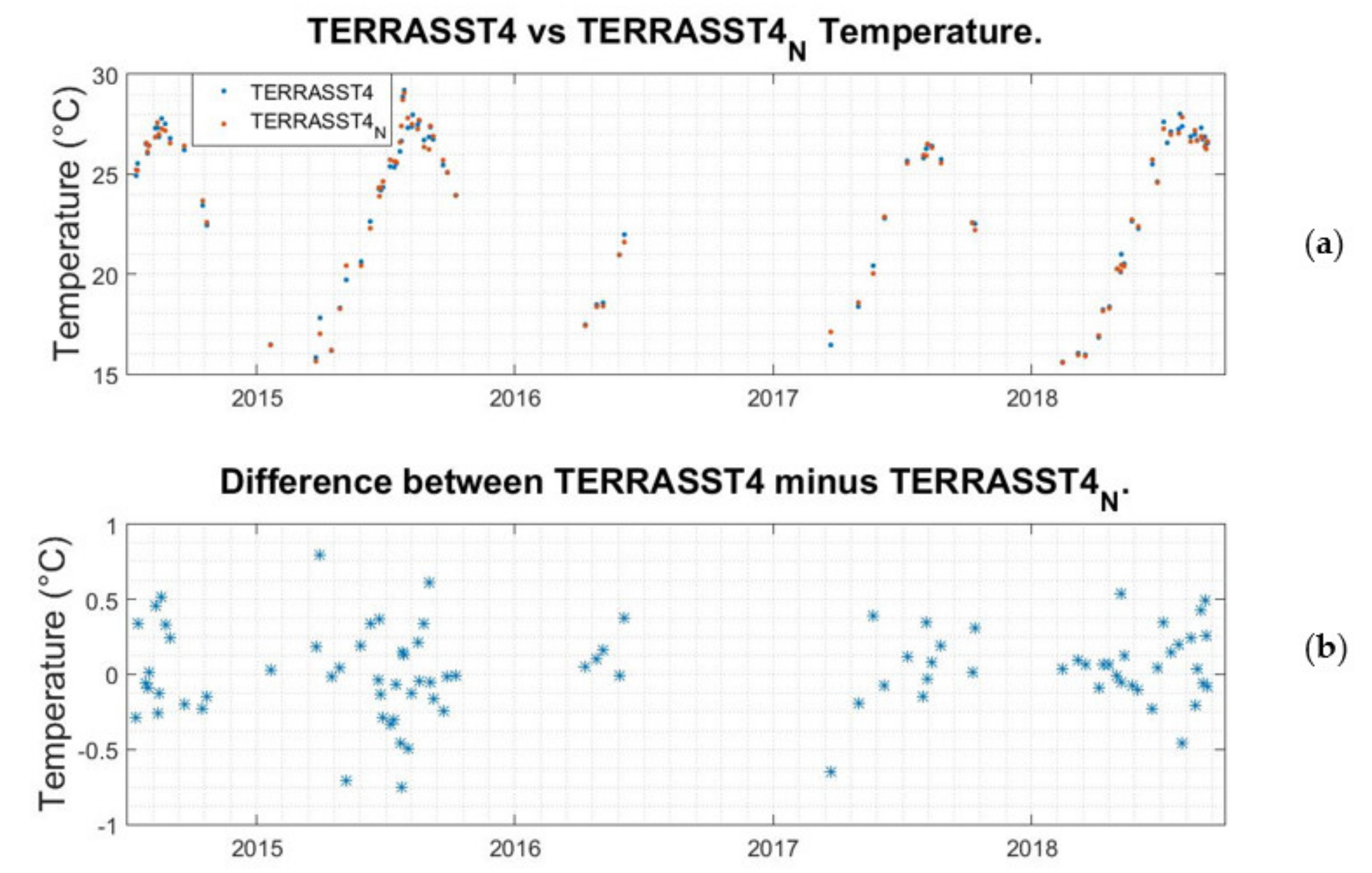
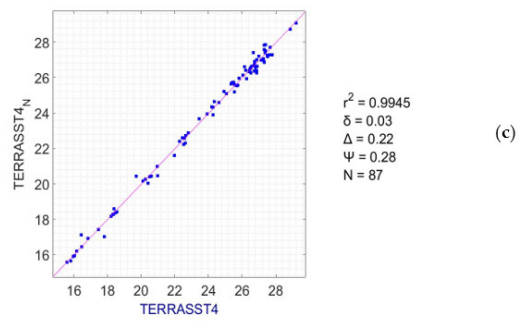
3.3. Comparison between the MODIS Aqua and Terra Data from the Cell Containing the Seafloor Observatory of the Underwater Biotechnological Park of Crete and the Northern Adjacent Cell
4. Discussion
5. Conclusions
Author Contributions
Funding
Acknowledgments
Conflicts of Interest
Appendix A

| Sensor | Year | Period |
|---|---|---|
| CTD | 2014 | 26/05/2014–31/12/2014 |
| 2015 | 01/01/2015–31/12/2015 | |
| 2016 | 01/01/2016–02/10/2016 & 07/12/2016–31/12/2016 | |
| 2017 | 01/01/2017–31/12/2017 | |
| 2018 | 01/01/2018–27/03/2018 | |
| HOBO1 | 2014 | 14/07/2014–31/12/2014 |
| 2015 | 01/01/2015–31/12/2015 | |
| 2016 | 01/01/2016–07/06/2016 & 09/12/2016–31/12/2016 | |
| 2017 | 01/01/2017–31/12/2017 | |
| 2018 | 01/01/2018–01/11/2018 | |
| HOBO2 | 2014 | 14/07/2014–31/12/2014 |
| 2015 | 01/01/2015–31/12/2015 | |
| 2016 | 01/01/2016–07/06/2016 & 09/12/2016–31/12/2016 | |
| 2017 | 01/01/2017–22/08/2017 | |
| 2018 | 27/03/2018–01/11/2018 | |
| HOBO3 | 2014 | 16/10/2014–31/12/2014 |
| 2015 | 01/01/2015–31/12/2015 | |
| 2016 | 01/01/2016–07/06/2016 & 09/12/2016–31/12/2016 | |
| 2017 | 01/01/2017–31/12/2017 | |
| 2018 | 01/01/2018–01/11/2018 |
| Sensor | Year | Mean | StD | SE | Min | Max | Days |
|---|---|---|---|---|---|---|---|
| CTD | 2014 | 23.2651 | 2.7996 | 0.194586 | 17.9808 | 27.3790 | 207 |
| 2015 | 20.6792 | 3.9237 | 0.205658 | 15.0753 | 27.7596 | 364 | |
| 2016 | 20.5336 | 4.1066 | 0.237095 | 15.4409 | 27.2247 | 300 | |
| 2017 | 20.4080 | 3.9063 | 0.204465 | 14.4606 | 27.0765 | 365 | |
| 2018 | 16.1836 | 0.4254 | 0.045872 | 15.5002 | 17.3387 | 86 | |
| HOBO1 | 2014 | 23.5580 | 3.1856 | 0.245046 | 16.0967 | 27.7329 | 169 |
| 2015 | 20.8872 | 4.0666 | 0.212856 | 14.9445 | 28.1352 | 365 | |
| 2016 | 17.6343 | 1.5589 | 0.115553 | 15.7778 | 22.3708 | 182 | |
| 2017 | 20.6020 | 4.0199 | 0.210411 | 14.3907 | 27.4004 | 365 | |
| 2018 | 21.4671 | 4.3554 | 0.249389 | 14.0752 | 27.6611 | 305 | |
| HOBO2 | 2014 | 23.5674 | 3.1649 | 0.243454 | 16.1505 | 27.8156 | 169 |
| 2015 | 20.8691 | 4.0223 | 0.210537 | 15.0354 | 27.8438 | 365 | |
| 2016 | 17.6100 | 1.5093 | 0.111877 | 15.7806 | 22.3003 | 182 | |
| 2017 | 19.8281 | 4.3129 | 0.281943 | 14.4217 | 27.2163 | 234 | |
| 2018 | 23.3735 | 3.3278 | 0.22436 | 16.1800 | 27.5739 | 220 | |
| HOBO3 | 2014 | 20.3626 | 1.7853 | 0.206149 | 15.3942 | 23.6355 | 75 |
| 2015 | 20.7576 | 3.9212 | 0.205245 | 15.0493 | 27.7035 | 365 | |
| 2016 | 17.5311 | 1.4586 | 0.108119 | 15.5188 | 22.1203 | 182 | |
| 2017 | 20.4538 | 3.9013 | 0.204203 | 14.4756 | 27.1492 | 365 | |
| 2018 | 21.3070 | 4.2799 | 0.245066 | 15.5077 | 27.5616 | 305 |
| Sensor | Year | Mean | StD | SE | Min | Max | Days |
|---|---|---|---|---|---|---|---|
| AQUASST | 2014 | 23.4166 | 3.5380 | 0.505429 | 16.2250 | 27.4900 | 49 |
| 2015 | 23.5043 | 3.6787 | 0.554585 | 15.8900 | 29.9450 | 44 | |
| 2016 | 22.8998 | 3.3402 | 0.427669 | 16.3550 | 28.8200 | 61 | |
| 2017 | 22.8295 | 4.1823 | 0.563941 | 14.5800 | 27.0400 | 55 | |
| 2018 | 25.2624 | 2.2572 | 0.301631 | 16.5900 | 27.6850 | 56 | |
| AQUASST4 | 2014 | 23.5379 | 3.2620 | 0.639731 | 16.7000 | 27.1550 | 26 |
| 2015 | 24.0261 | 3.2073 | 0.617245 | 16.3850 | 28.8450 | 27 | |
| 2016 | 23.2771 | 3.2781 | 0.642888 | 17.4700 | 27.1550 | 26 | |
| 2017 | 23.6767 | 3.1903 | 0.713373 | 16.4550 | 26.4850 | 20 | |
| 2018 | 25.3684 | 2.8590 | 0.5718 | 16.7300 | 27.6600 | 25 | |
| TERRASST | 2014 | 22.5046 | 3.8579 | 0.42346 | 12.1800 | 27.4400 | 83 |
| 2015 | 23.4049 | 3.8319 | 0.436686 | 14.6950 | 28.6600 | 77 | |
| 2016 | 22.8998 | 3.3402 | 0.427669 | 16.3550 | 28.8200 | 61 | |
| 2017 | 22.8295 | 4.1823 | 0.563941 | 14.5800 | 27.0400 | 55 | |
| 2018 | 23.1479 | 4.1998 | 0.491549 | 14.4050 | 27.9300 | 73 | |
| TERRASST4 | 2014 | 22.5683 | 3.9895 | 0.59472 | 15.4100 | 27.7850 | 45 |
| 2015 | 23.9990 | 3.8150 | 0.545 | 15.8250 | 29.2050 | 49 | |
| 2016 | 23.2771 | 3.2781 | 0.642888 | 17.4700 | 27.1550 | 26 | |
| 2017 | 23.6767 | 3.1903 | 0.713373 | 16.4550 | 26.4850 | 20 | |
| 2018 | 24.0743 | 3.8630 | 0.507237 | 15.6000 | 28.0150 | 58 | |
| AQUASST_N | 2014 | 23.3129 | 3.5346 | 0.510176 | 16.1050 | 27.4100 | 48 |
| 2015 | 23.4441 | 3.4335 | 0.542884 | 15.7800 | 29.7650 | 40 | |
| 2016 | 22.9784 | 3.3350 | 0.437907 | 16.2700 | 28.6000 | 58 | |
| 2017 | 22.7984 | 4.2106 | 0.627679 | 14.5950 | 27.0400 | 45 | |
| 2018 | 25.3579 | 2.3345 | 0.336956 | 16.4750 | 27.5100 | 48 | |
| AQUASST4_N | 2014 | 23.3467 | 3.3631 | 0.659558 | 16.2850 | 27.1750 | 26 |
| 2015 | 24.0608 | 2.8468 | 0.56936 | 17.3750 | 28.6800 | 25 | |
| 2016 | 23.3600 | 3.2674 | 0.6813 | 17.4200 | 27.1400 | 23 | |
| 2017 | 23.4629 | 3.1871 | 0.731171 | 16.5150 | 26.5750 | 19 | |
| 2018 | 25.0714 | 2.8814 | 0.614317 | 16.6900 | 27.5350 | 22 | |
| TERRASST_N | 2014 | 22.2908 | 3.8583 | 0.445518 | 12.1650 | 27.3250 | 75 |
| 2015 | 23.4556 | 3.7451 | 0.447625 | 14.8900 | 28.7600 | 70 | |
| 2016 | 22.9784 | 3.3350 | 0.437907 | 16.2700 | 28.6000 | 58 | |
| 2017 | 22.7984 | 4.2106 | 0.627679 | 14.5950 | 27.0400 | 45 | |
| 2018 | 22.7552 | 4.3419 | 0.560537 | 14.5200 | 27.4750 | 60 | |
| TERRASST4_N | 2014 | 22.3801 | 3.9640 | 0.626763 | 15.6400 | 27.4450 | 40 |
| 2015 | 23.8145 | 3.9018 | 0.575289 | 15.9800 | 28.7150 | 46 | |
| 2016 | 23.3600 | 3.2674 | 0.6813 | 17.4200 | 27.1400 | 23 | |
| 2017 | 23.4629 | 3.1871 | 0.731171 | 16.5150 | 26.5750 | 19 | |
| 2018 | 23.6804 | 3.9737 | 0.573554 | 16.0700 | 27.6750 | 48 |
References
- European Parliament. The Impact of Tourism on Coastal Areas: Regional Development Aspects, Study of Policy Department B: Structural and Cohesion Policies; European Parliament: Brussels, Belgium, 2008. [Google Scholar]
- Lu, Y.; Yuan, J.; Lu, X.; Su, C.; Zhang, Y.; Wang, C.; Cao, X.; Li, Q.; Su, J.; Ittekkot, V.; et al. Major threats of pollution and climate change to global coastal ecosystems and enhanced management for sustainability. Environ. Pollut. 2018, 239, 670–680. [Google Scholar] [CrossRef] [PubMed]
- McCaul, M.; Barland, J.; Cleary, J.; Cahalane, C.; McCarthy, T.; Diamond, D. Combining remote temperature sensing with in-situ sensing to track marine/freshwater mixing dynamics. Sensors 2016, 16, 1402. [Google Scholar] [CrossRef] [PubMed]
- Thomas, A.; Byrne, D.; Weatherbee, R. Coastal sea surface temperature variability from Landsat infrared data. Remote Sens. Environ. 2002, 81, 262–272. [Google Scholar] [CrossRef]
- Varela, R.; Lima, F.P.; Seabra, R.; Meneghesso, C.; Gómez-Gesteira, M. Coastal warming and wind-driven upwelling: A global analysis. Sci. Total Environ. 2018, 639, 1501–1511. [Google Scholar] [CrossRef]
- Yamamoto, T.; Nadaoka, K. Analyzing coastal turbidity under complex terrestrial loads characterized by a “stress connectivity matrix” with an atmosphere-watershed-coastal ocean coupled model. Estuar. Coast. Shelf Sci. 2018, 203, 44–58. [Google Scholar] [CrossRef]
- Tang, D.; Kester, D.R.; Wang, Z.; Lian, J.; Kawamura, H. AVHRR satellite remote sensing and shipboard measurements of the thermal plume from the Daya Bay, nuclear power station, China. Remote Sens. Environ. 2003, 84, 506–515. [Google Scholar] [CrossRef]
- Ishizu, M.; Miyazawa, Y.; Tsunoda, T.; Guo, X. Development of a biogeochemical and carbon model related to ocean acidification indices with an operational ocean model product in the north western pacific. Sustainability 2019, 11, 2677. [Google Scholar] [CrossRef]
- Rabalais, N.N.; Turner, R.E.; Díaz, R.J.; Justić, D. Global change and eutrophication of coastal waters. ICES J. Mar. Sci. 2009, 66, 1528–1537. [Google Scholar] [CrossRef]
- Nilsson, J.A.; Fulton, E.A.; Johnson, C.R.; Haward, M. How to sustain fisheries: Expert knowledge from 34 nations. Water 2019, 11, 213. [Google Scholar] [CrossRef]
- Bulleri, F.; Chapman, M.G. The introduction of coastal infrastructure as a driver of change in marine environments. J. Appl. Ecol. 2010, 47, 26–35. [Google Scholar] [CrossRef]
- Vergés, A.; Steinberg, P.D.; Hay, M.E.; Poore, A.G.B.; Campbell, A.H.; Ballesteros, E.; Heck, K.L.; Booth, D.J.; Coleman, M.A.; Feary, D.A.; et al. The tropicalization of temperate marine ecosystems: Climate-mediated changes in herbivory and community phase shifts. Proc. R. Soc. B 2014, 281, 20140846. [Google Scholar] [CrossRef] [PubMed]
- Harley, C.D.G.; Randall Hughes, A.; Hultgren, K.M.; Miner, B.G.; Sorte, C.J.B.; Thornber, C.S.; Rodriguez, L.F.; Tomanek, L.; Williams, S.L. The impacts of climate change in coastal marine systems: Climate change in coastal marine systems. Ecol. Lett. 2006, 9, 228–241. [Google Scholar] [CrossRef] [PubMed]
- Halpern, B.S.; Walbridge, S.; Selkoe, K.A.; Kappel, C.V.; Micheli, F.; D’Agrosa, C.; Bruno, J.F.; Casey, K.S.; Ebert, C.; Fox, H.E.; et al. A global map of human impact on marine ecosystems. Science 2008, 319, 948–952. [Google Scholar] [CrossRef] [PubMed]
- Hansen, J.; Ruedy, R.; Sato, M.; Lo, K. Global surface temperature change. Rev. Geophys. 2010, 48, RG4004. [Google Scholar] [CrossRef]
- Lima, F.P.; Wethey, D.S. Three decades of high-resolution coastal sea surface temperatures reveal more than warming. Nat. Commun. 2012, 3, 704. [Google Scholar] [CrossRef]
- Sea Surface Temperature, Essential Climate Variable (ECV) Factsheet, Global Climate Observing System.
- Smit, A.J.; Roberts, M.; Anderson, R.J.; Dufois, F.; Dudley, S.F.J.; Bornman, T.G.; Olbers, J.; Bolton, J.J. A coastal seawater temperature dataset for biogeographical studies: Large biases between in situ and remotely-sensed data sets around the coast of south Africa. PLoS ONE 2013, 8, e81944. [Google Scholar] [CrossRef]
- Banks, A.C.; Mélin, F. An assessment of cloud masking schemes for satellite ocean colour data of marine optical extremes. Int. J. Remote Sens. 2015, 36, 797–821. [Google Scholar] [CrossRef]
- Mélin, F.; Vantrepotte, V. How optically diverse is the coastal ocean? Remote Sens. Environ. 2015, 160, 235–251. [Google Scholar] [CrossRef]
- Brewin, R.; Smale, D.; Moore, P.; Dall’Olmo, G.; Miller, P.; Taylor, B.; Smyth, T.; Fishwick, J.; Yang, M. Evaluating operational AVHRR sea surface temperature data at the coastline using benthic temperature loggers. Remote Sens. 2018, 10, 925. [Google Scholar] [CrossRef]
- Thakur, K.K.; Vanderstichel, R.; Barrell, J.; Stryhn, H.; Patanasatienkul, T.; Revie, C.W. Comparison of remotely-sensed sea surface temperature and salinity products with in situ measurements from British Columbia, Canada. Front. Mar. Sci. 2018, 5, 121. [Google Scholar] [CrossRef]
- Castillo, K.D.; Lima, F.P. Comparison of in situ and satellite-derived (MODIS-Aqua/Terra) methods for assessing temperatures on coral reefs: Subtidal and SSTs on coral reefs. Limnol. Oceanogr. Methods 2010, 8, 107–117. [Google Scholar] [CrossRef]
- Delgado, A.L.; Jamet, C.; Loisel, H.; Vantrepotte, V.; Perillo, G.M.E.; Piccolo, M.C. Evaluation of the MODIS-Aqua Sea-Surface Temperature product in the inner and mid-shelves of southwest Buenos Aires Province, Argentina. Int. J. Remote Sens. 2014, 35, 306–320. [Google Scholar] [CrossRef]
- Baldock, J.; Bancroft, K.P.; Williams, M.; Shedrawi, G.; Field, S. Accurately estimating local water temperature from remotely sensed satellite sea surface temperature: A near real-time monitoring tool for marine protected areas. Ocean Coast. Manag. 2014, 96, 73–81. [Google Scholar] [CrossRef]
- Smale, D.; Wernberg, T. Satellite-derived SST data as a proxy for water temperature in nearshore benthic ecology. Mar. Ecol. Prog. Ser. 2009, 387, 27–37. [Google Scholar] [CrossRef]
- Stobart, B.; Mayfield, S.; Mundy, C.; Hobday, A.J.; Hartog, J.R. Comparison of in situ and satellite sea surface-temperature data from South Australia and Tasmania: How reliable are satellite data as a proxy for coastal temperatures in temperate southern Australia? Mar. Freshwater Res. 2016, 67, 612–625. [Google Scholar] [CrossRef]
- Lathlean, J.; Ayre, D.; Minchinton, T. Rocky intertidal temperature variability along the southeast coast of Australia: Comparing data from in situ loggers, satellite-derived SST and terrestrial weather stations. Mar. Ecol. Prog. Ser. 2011, 439, 83–95. [Google Scholar] [CrossRef]
- Alvera- Azcárate, A.; Troupin, C.; Barth, A.; Beckers, J.-M. Comparison between satellite and in situ sea surface temperature data in the Western Mediterranean Sea. Ocean Dyn. 2011, 61, 767–778. [Google Scholar] [CrossRef]
- Bernardello, R.; Serrano, E.; Coma, R.; Ribes, M.; Bahamon, N. A comparison of remote-sensing SST and in situ seawater temperature in near-shore habitats in the western Mediterranean Sea. Mar. Ecol. Prog. Ser. 2016, 559, 21–34. [Google Scholar] [CrossRef]
- Robles-Tamayo, C.; Valdez-Holguín, J.; García-Morales, R.; Figueroa-Preciado, G.; Herrera-Cervantes, H.; López-Martínez, J.; Enríquez-Ocaña, L. Sea surface temperature (SST) variability of the eastern coastal zone of the gulf of California. Remote Sens. 2018, 10, 1434. [Google Scholar] [CrossRef]
- Cavalli, R. Retrieval of sea surface temperature from MODIS data in coastal waters. Sustainability 2017, 9, 2032. [Google Scholar] [CrossRef]
- Cavalli, R. Comparison of split window algorithms for retrieving measurements of sea surface temperature from MODIS data in near-land coastal waters. Int. J. Geo-Inf. 2018, 7, 30. [Google Scholar] [CrossRef]
- Mueller, J.L.; Austin, R.W.; Morel, A.; Fargion, G.S.; McClain, C.R. Ocean Optics Protocols for Satellite Ocean Color Sensor Validation, Revision 4, Volume I: Introduction. Background and Conventions; NASA Technical Memorandum 2003-21621; NASA Goddard Space Flight Center: Greenbelt, MD, USA, 2003; pp. 1–56.
- Gerovasileiou, V.; Akel, E.K.; Akyol, O.K.; Alongi, G.; Azevedo, F.; Babali, N.; Bakiu, R.; Bariche, M.; Bennoui, A.; Castriota, L.; et al. New mediterranean biodiversity records. Medit. Mar. Sci. 2017, 18, 355–384. [Google Scholar] [CrossRef]
- Zenetos, A.; Corsini-Foka, M.; Crocetta, F.; Gerovasileiou, V.; Karachle, P.; Simboura, N.; Tsiamis, K.; Pancucci-Papadopoulou, M.-A. Deep cleaning of alien and cryptogenic species records in the Greek Seas (2018 update). Manag. Biol. Invasions 2018, 9, 209–226. [Google Scholar] [CrossRef]
- Mytilineou, C.; Akel, E.K.; Babali, N.; Balistreri, P.; Bariche, M.; Boyaci, Y.Ö.; Cilenti, L.; Constantinou, C.; Crocetta, F.; Çelik, M.; et al. New mediterranean biodiversity records. Medit. Mar. Sci. 2016, 17, 794–821. [Google Scholar] [CrossRef]
- SAIV A/S. Operating Manual for STD/CTD Model SD208 with Sound Velocity & Optional Sensors; SAIV A/S: Bergen, Norway, 2009; pp. 1-01–8-04. [Google Scholar]
- Minnett, P.; Kaiser-Weiss, A. Discussion document: Near-surface oceanic temperature gradients. Group for High Resolution Sea Surface Temperature (GHRSST), Version 12 January 2012. Available online: https://www.ghrsst.org/wp-content/uploads/2016/10/SSTDefinitionsDiscussion.pdf (accessed on 17 March 2020).
- Donlon, C.J.; Minnett, P.J.; Gentemann, C.; Nightingale, T.J.; Barton, I.J.; Ward, B.; Murray, M.J. Toward improved validation of satellite sea surface skin temperature measurements for climate research. J. Clim. 2002, 15, 353–369. [Google Scholar] [CrossRef]
- O’Carroll, A.G.; Eyre, J.R.; Saunders, R.W. Three-way error analysis between AATSR, AMSR-E, and in situ sea surface temperature observations. J. Atmos. Ocean. Technol. 2008, 25, 1197–1207. [Google Scholar] [CrossRef]
- Gentemann, C.L. Three way validation of MODIS and AMSR-E sea surface temperatures. J. Geophys. Res. Oceans 2014, 119, 2583–2598. [Google Scholar] [CrossRef]
- Xu, F.; Ignatov, A. Error characterization in i Quam SSTs using triple collocations with satellite measurements. Geophys. Res. Lett. 2016, 43, 10–826. [Google Scholar] [CrossRef]
- ESA, SPPA, Sensor Performance, Products and Algorithms. Available online: https://earth.esa.int/web/sppa/activities/frm (accessed on 8 January 2020).
- QA4EO, Quality assurance framework for earth observation. Available online: http://qa4eo.org/ (accessed on 8 January 2020).
- ESA Fiducial Reference Measurements: FRM. Available online: https://earth.esa.int/web/sppa/activities/frm (accessed on 13 January 2020).
- Fiducial Reference Measurements for Satellite Ocean Colour. Available online: https://frm4soc.org/ (accessed on 8 January 2020).
- Bahr, K.D.; Jokiel, P.L.; Rodgers, K.S. Influence of solar irradiance on underwater temperature recorded by temperature loggers on coral reefs: Evaluation of underwater temperature loggers. Limnol. Oceanogr. Methods 2016, 14, 338–342. [Google Scholar] [CrossRef]
- Brewin, R.J.W.; Cyronak, T.; Bresnahan, P.J.; Andersson, A.J.; Richard, J.; Hammond, K.; Billson, O.; de Mora, L.; Jackson, T.; Smale, D.; et al. Comparison of two methods for measuring sea surface temperature when surfing. Oceans 2020, 1, 2. [Google Scholar] [CrossRef]


| r2 | δ | Δ | Ψ | N | % of Matchups with Difference >2 °C/>3 °C | |
|---|---|---|---|---|---|---|
| HOBO3–CTD | 0.9970 | 0.06 | 0.12 | 0.21 | 1066 | - |
| HOBO1–HOBO2 | 0.9987 | 0.05 | 0.16 | 0.16 | 1170 | 0.004%/0% |
| HOBO1–HOBO3 | 0.9916 | 0.13 | 0.18 | 0.40 | 1292 | 1.17%/0.33% |
| HOBO2–HOBO3 | 0.9952 | 0.11 | 0.13 | 0.30 | 1076 | 0.53%/0.06% |
| r2 | δ | Δ | Ψ | N | |
|---|---|---|---|---|---|
| SSTskin–AQUASST4 | 0.9847 | −0.08 | 0.27 | 0.42 | 92 |
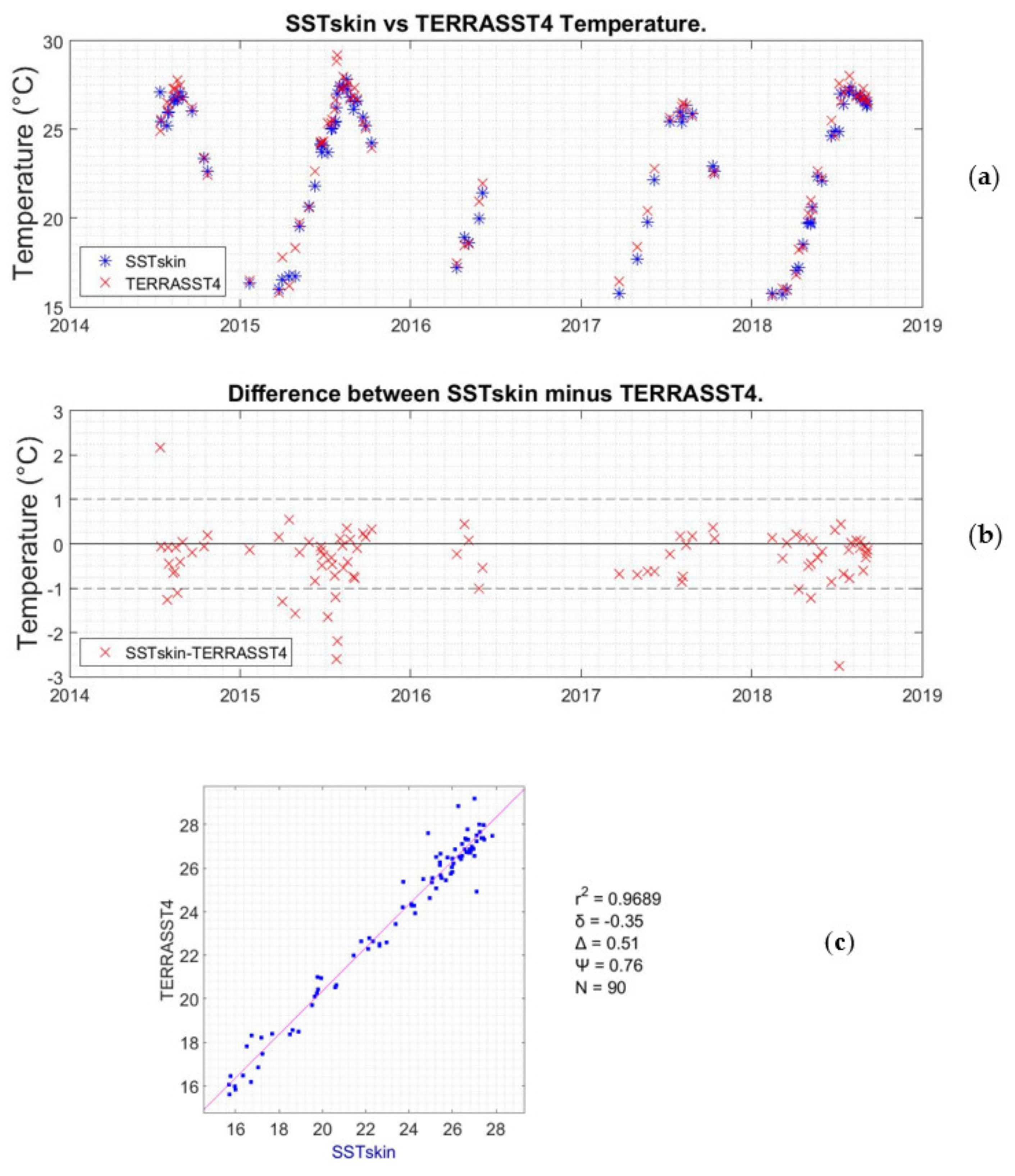
| SSTskin–TERRASST4 | 0.9689 | −0.35 | 0.51 | 0.76 | 90 |
| r2 | δ | Δ | Ψ | N | |
|---|---|---|---|---|---|
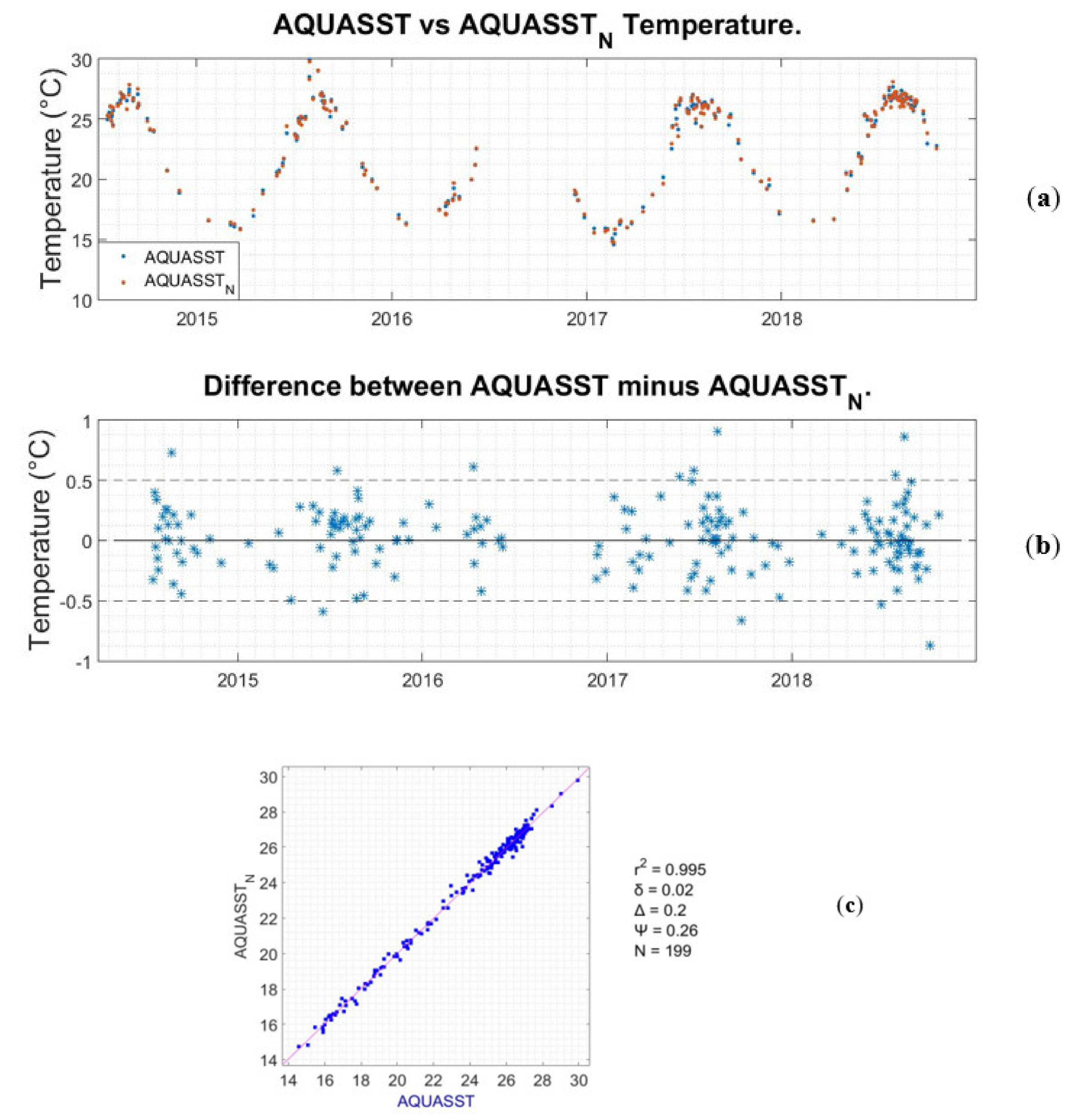
| AQUASST–AQUASST_N | 0.9950 | 0.02 | 0.20 | 0.26 | 199 |
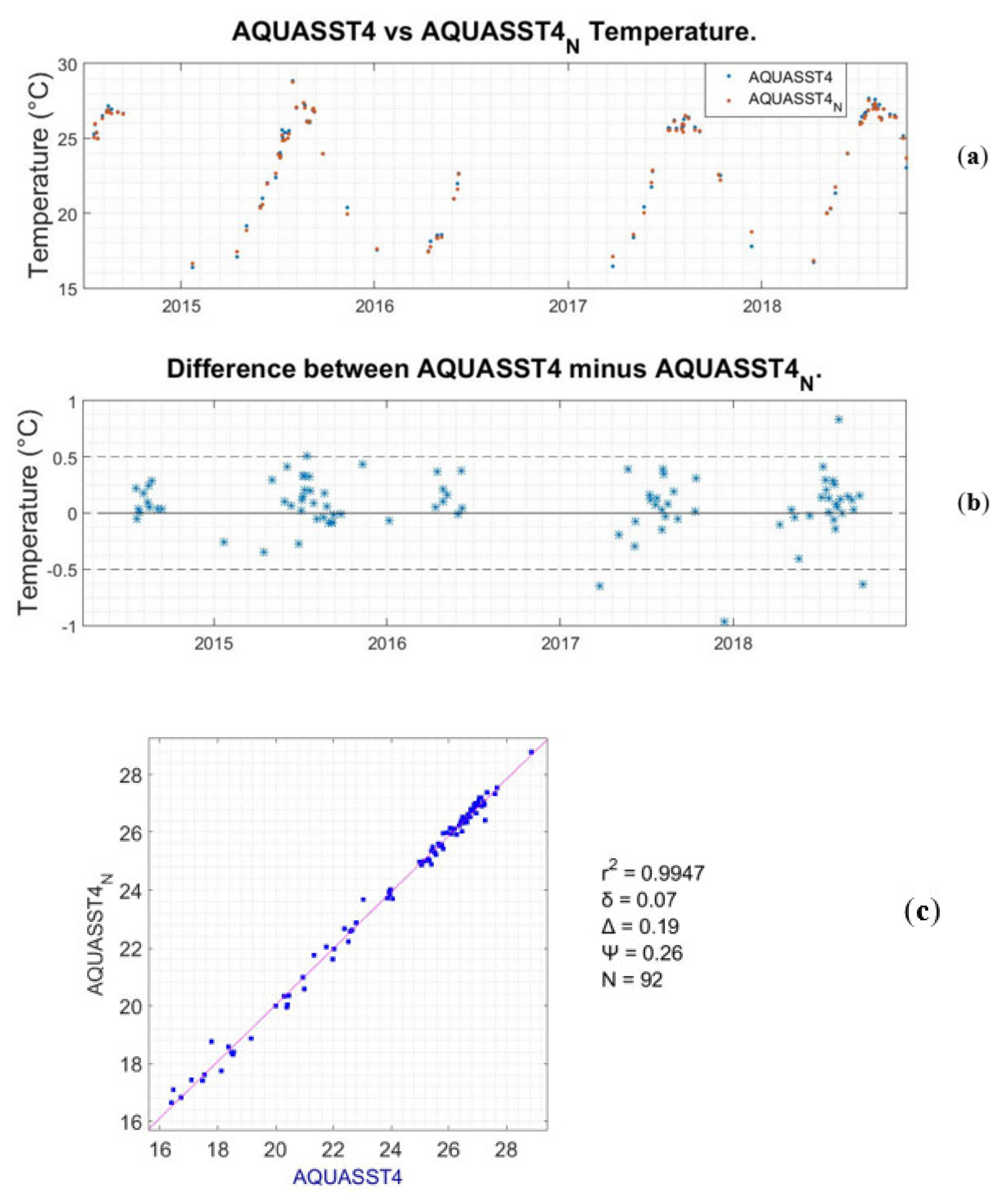
| AQUASST4–AQUASST4_N | 0.9947 | 0.07 | 0.19 | 0.26 | 92 |
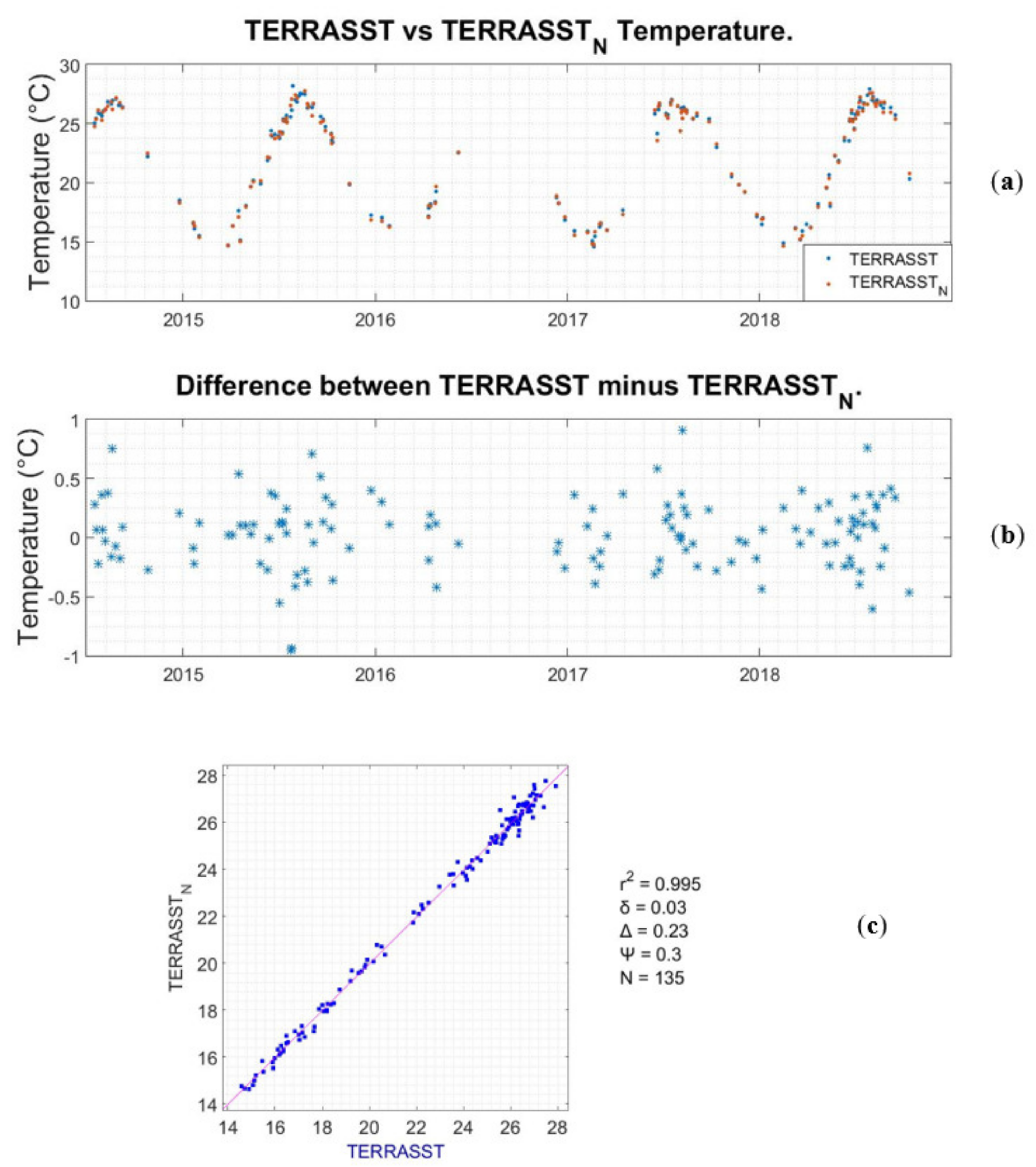
| TERRASST–TERRASST_N | 0.9950 | 0.03 | 0.23 | 0.30 | 135 |
| TERRASST4–TERRASST4_N | 0.9945 | 0.03 | 0.22 | 0.28 | 87 |
© 2020 by the authors. Licensee MDPI, Basel, Switzerland. This article is an open access article distributed under the terms and conditions of the Creative Commons Attribution (CC BY) license (http://creativecommons.org/licenses/by/4.0/).
Share and Cite
Androulakis, D.N.; Banks, A.C.; Dounas, C.; Margaris, D.P. An Evaluation of Autonomous In Situ Temperature Loggers in a Coastal Region of the Eastern Mediterranean Sea for Use in the Validation of Near-Shore Satellite Sea Surface Temperature Measurements. Remote Sens. 2020, 12, 1140. https://doi.org/10.3390/rs12071140
Androulakis DN, Banks AC, Dounas C, Margaris DP. An Evaluation of Autonomous In Situ Temperature Loggers in a Coastal Region of the Eastern Mediterranean Sea for Use in the Validation of Near-Shore Satellite Sea Surface Temperature Measurements. Remote Sensing. 2020; 12(7):1140. https://doi.org/10.3390/rs12071140
Chicago/Turabian StyleAndroulakis, Dimitrios N., Andrew Clive Banks, Costas Dounas, and Dionissios P. Margaris. 2020. "An Evaluation of Autonomous In Situ Temperature Loggers in a Coastal Region of the Eastern Mediterranean Sea for Use in the Validation of Near-Shore Satellite Sea Surface Temperature Measurements" Remote Sensing 12, no. 7: 1140. https://doi.org/10.3390/rs12071140
APA StyleAndroulakis, D. N., Banks, A. C., Dounas, C., & Margaris, D. P. (2020). An Evaluation of Autonomous In Situ Temperature Loggers in a Coastal Region of the Eastern Mediterranean Sea for Use in the Validation of Near-Shore Satellite Sea Surface Temperature Measurements. Remote Sensing, 12(7), 1140. https://doi.org/10.3390/rs12071140