Harmonized Landsat 8 and Sentinel-2 Time Series Data to Detect Irrigated Areas: An Application in Southern Italy
Abstract
1. Introduction
HLS Project
2. Materials and Methods
2.1. Dataset
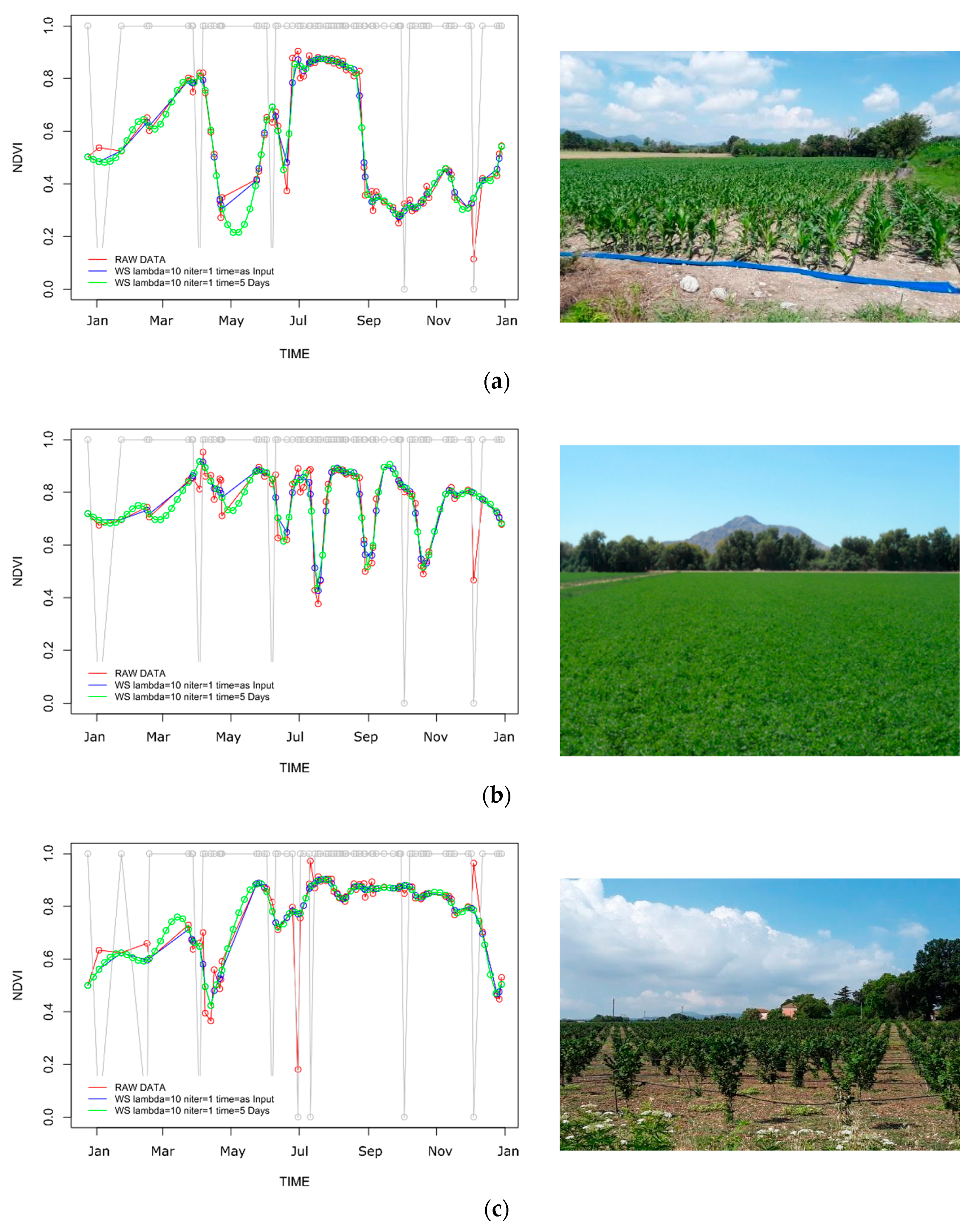
2.2. Satellite Data Collection and Preprocessing
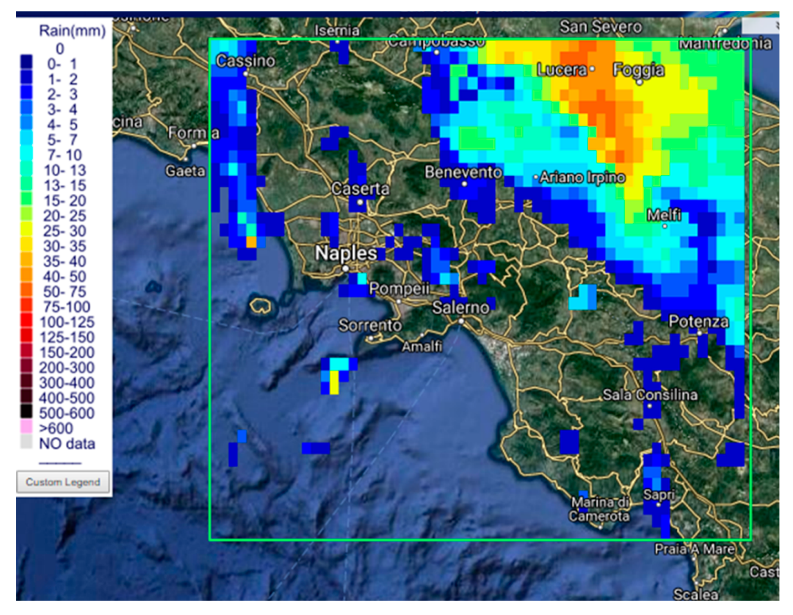
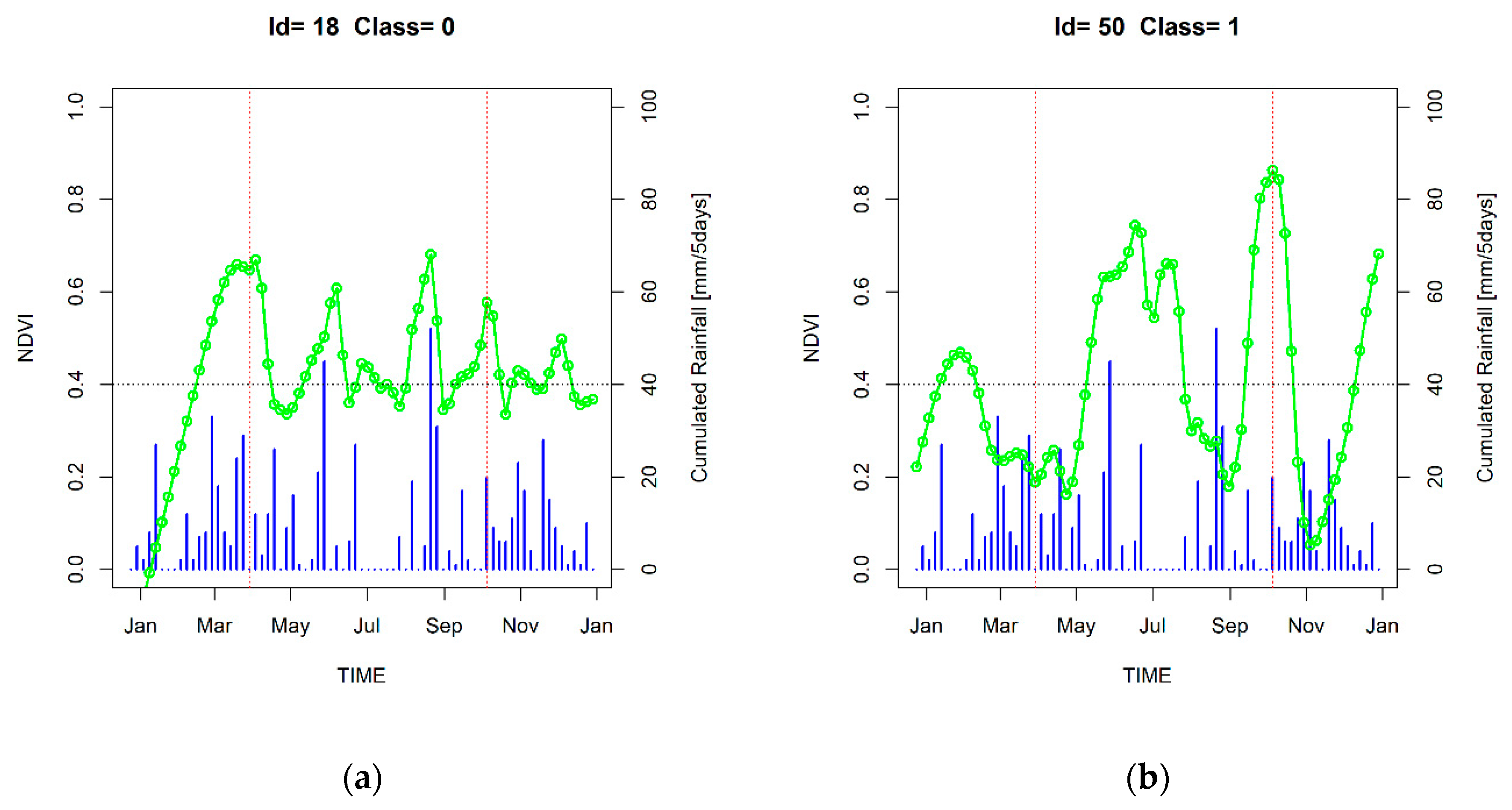
2.3. Satellite Precipitation Data Collection and Preprocessing
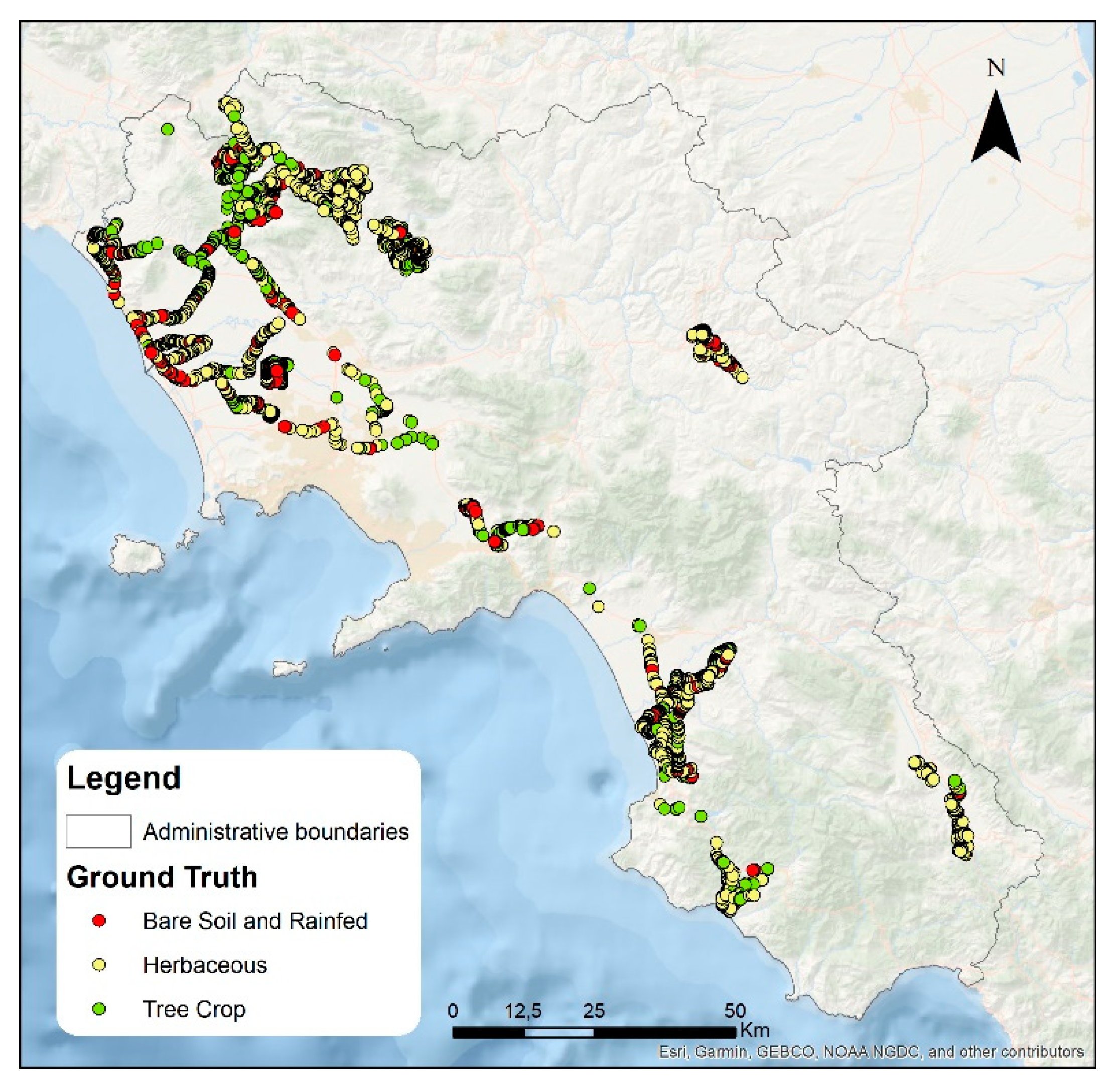
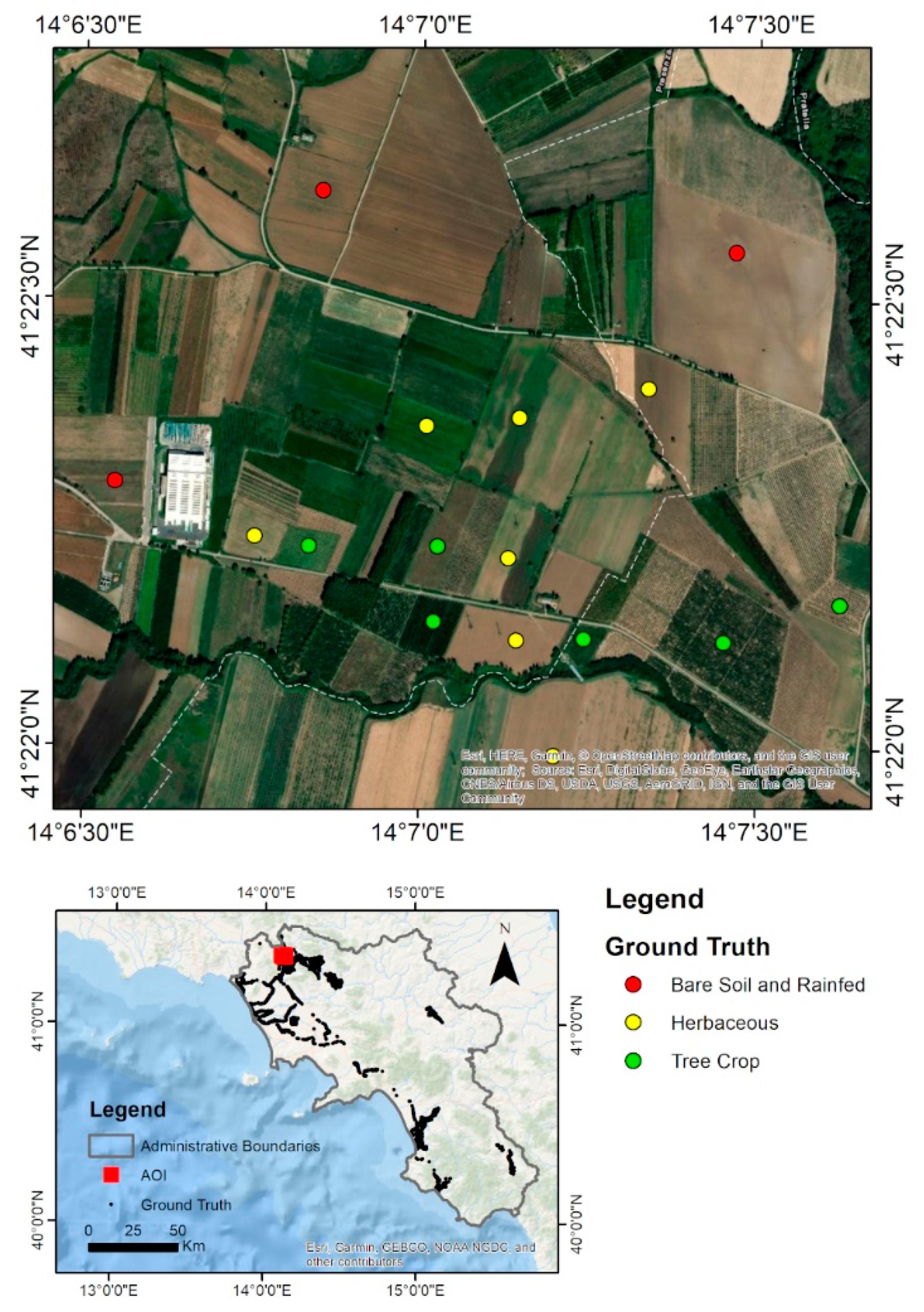
2.4. Ground Truth Acquisition
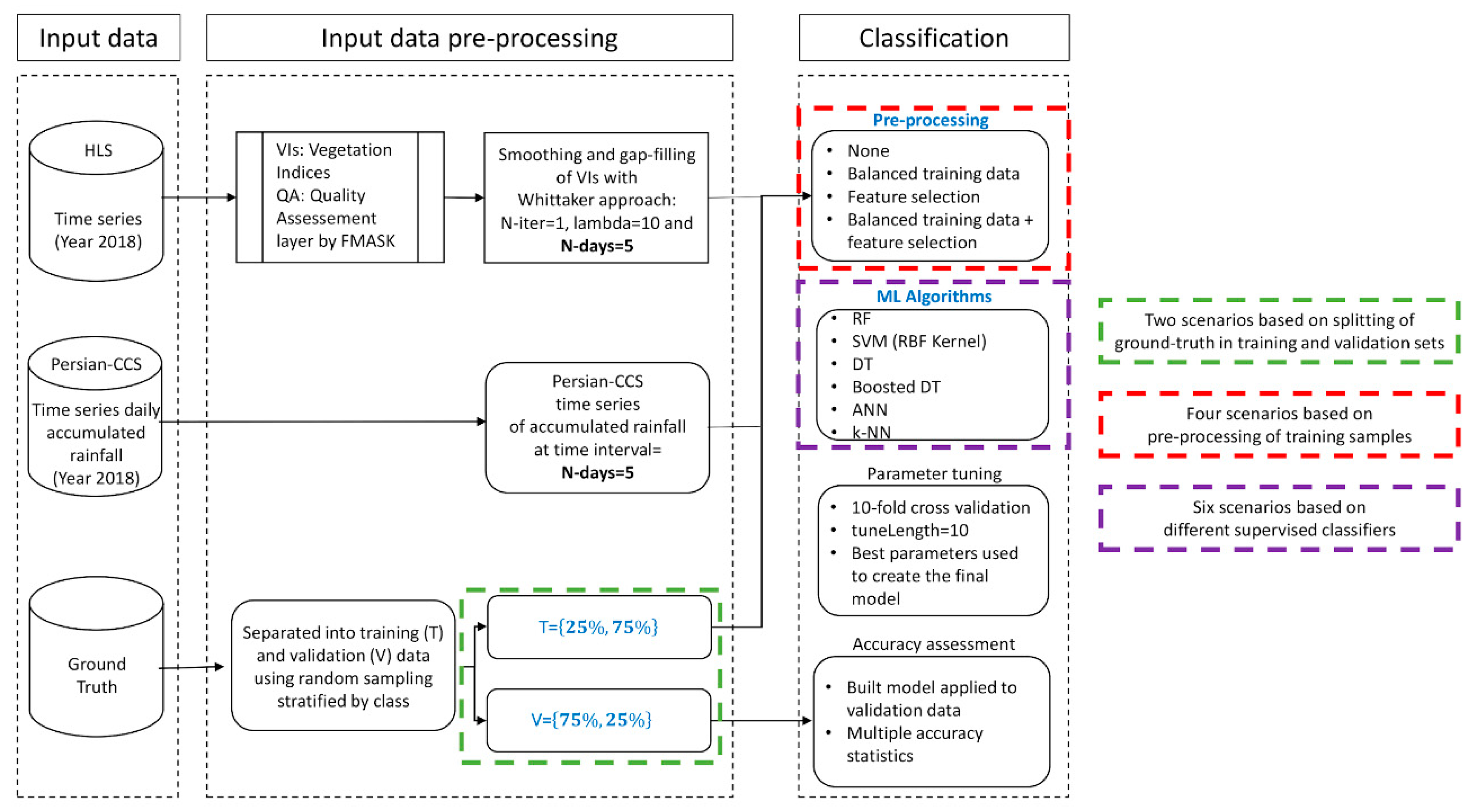
2.5. Machine Learning-Based Supervised Classification
3. Results and Discussion
3.1. Experimental Setting for Irrigated Area Classification Assessment
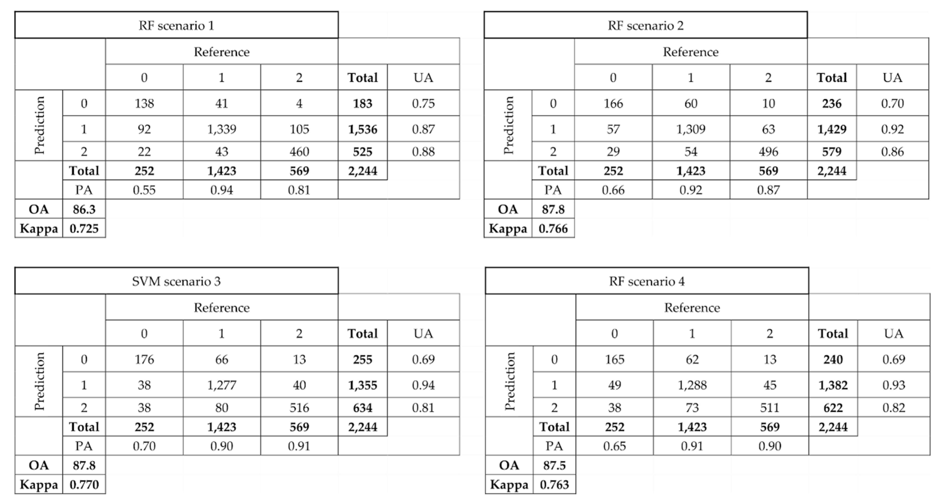
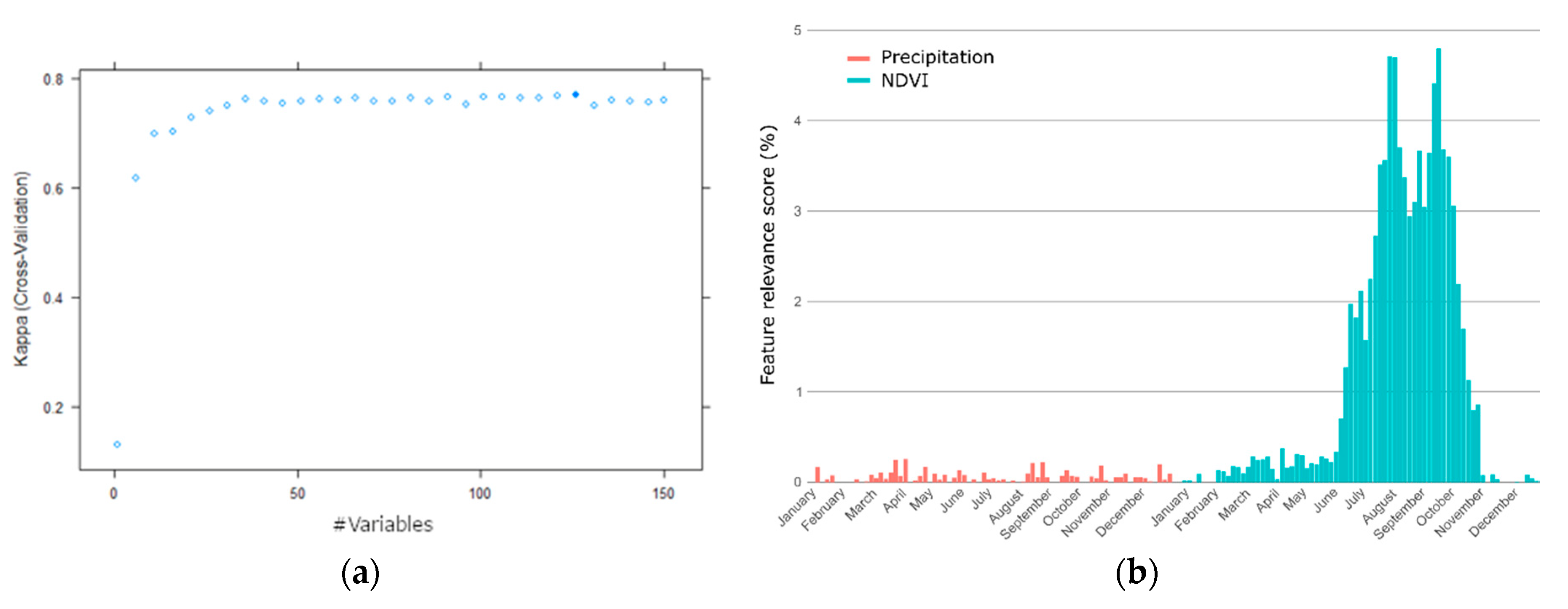
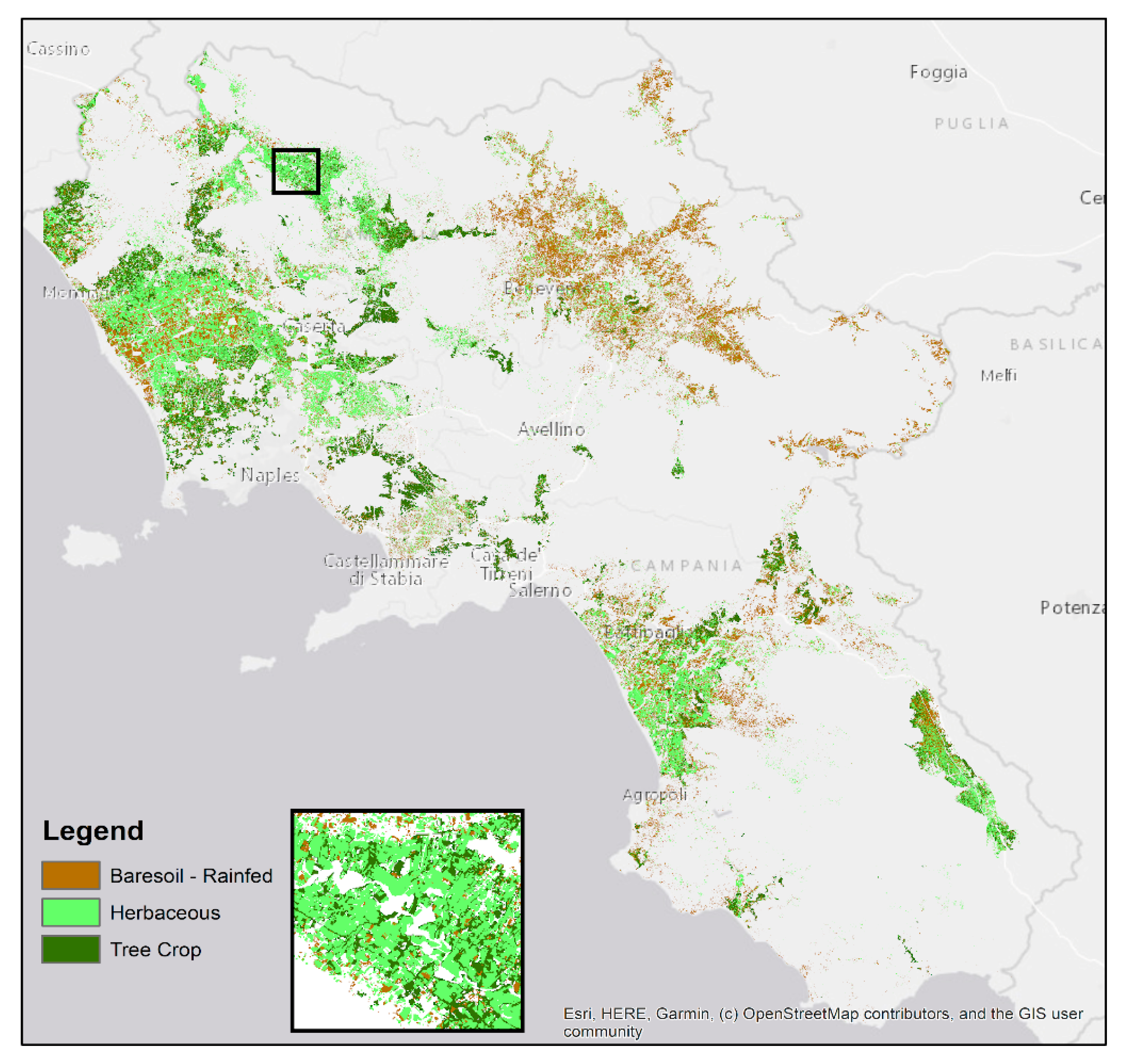
3.2. Experimental Results
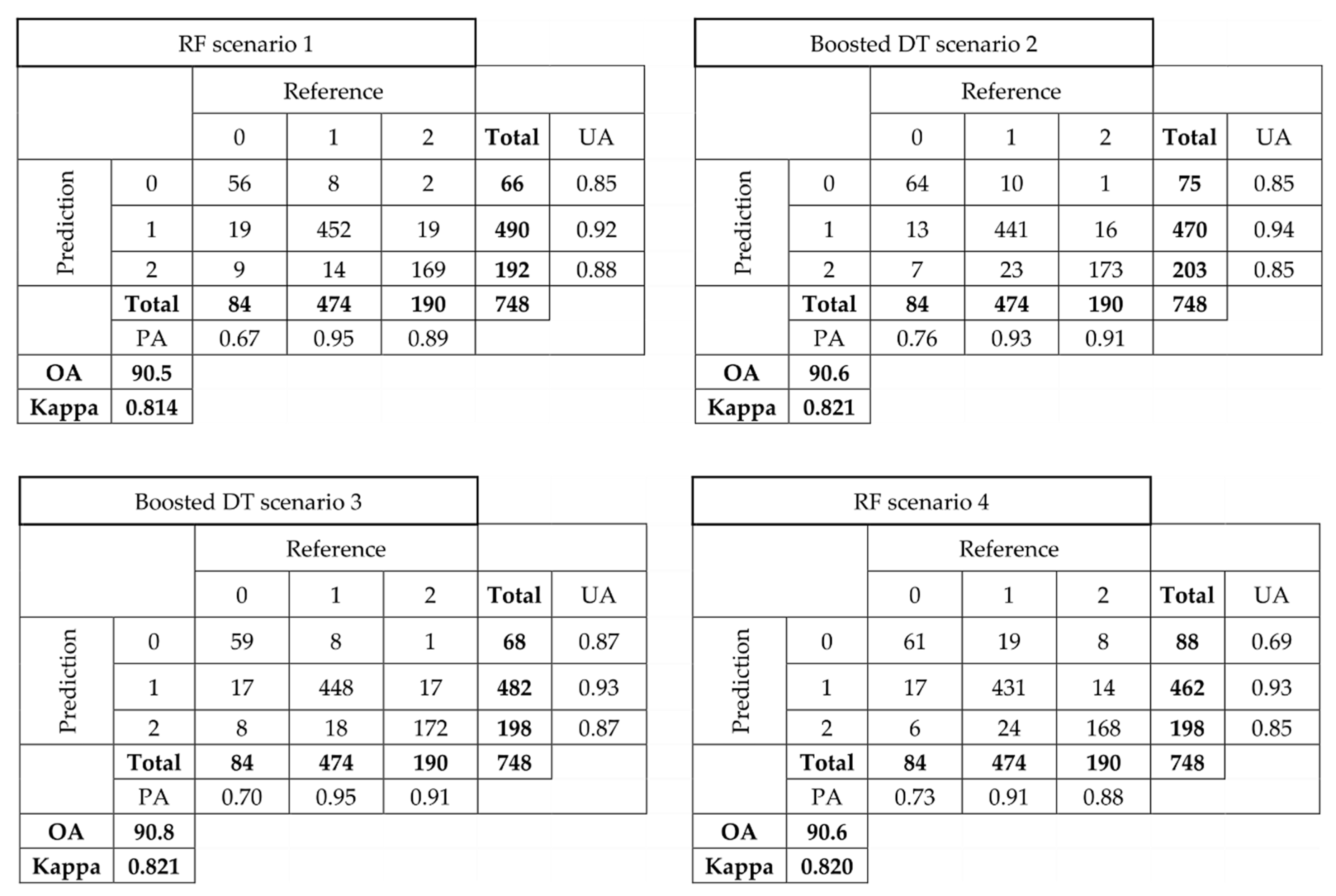
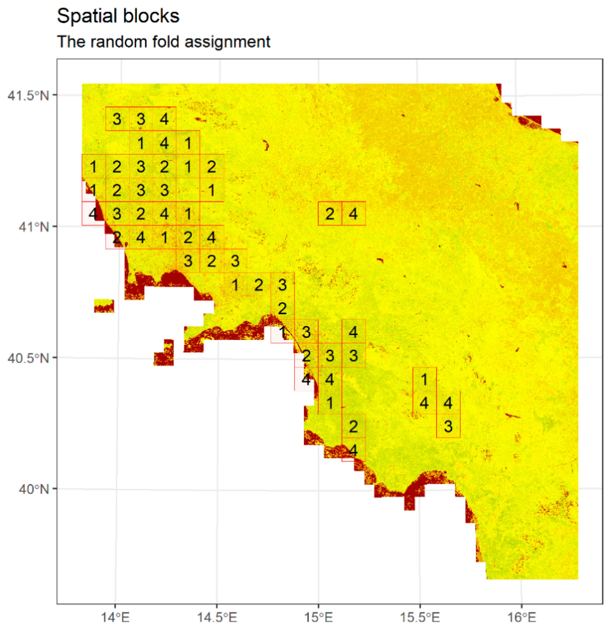
3.3. Cross-Validation with Spatially Separated Folds
4. Discussion and Conclusion
Author Contributions
Funding
Acknowledgments
Conflicts of Interest
References
- Vörösmarty, C.J. Global water assessment and potential contributions from Earth Systems Science. Aquat. Sci. 2002, 64, 328–351. [Google Scholar] [CrossRef]
- Boucher, O.; Myhre, G.; Myhre, A. Direct human influence of irrigation on atmospheric water vapour and climate. Clim. Dyn. 2004, 22, 597–603. [Google Scholar] [CrossRef]
- Alcamo, J.; Döll, P.; Henrichs, T.; Kaspar, F.; Lehner, B.; Rösch, T.; Siebert, S. Global estimates of water withdrawals and availability under current and future “business-as-usual” conditions. Hydrol. Sci. J. 2003, 48, 339–348. [Google Scholar] [CrossRef]
- Peña-Arancibia, J.L.; McVicar, T.R.; Paydar, Z.; Li, L.; Guerschman, J.P.; Donohue, R.J.; Dutta, D.; Podger, G.M.; van Dijk, A.I.J.M.; Chiew, F.H.S. Dynamic identification of summer cropping irrigated areas in a large basin experiencing extreme climatic variability. Remote Sens. Environ. 2014, 154, 139–152. [Google Scholar] [CrossRef]
- Pervez, S.; Budde, M.; Rowland, J. Mapping irrigated areas in Afghanistan over the past decade using MODIS NDVI. Remote Sens. Environ. 2014, 149, 155–165. [Google Scholar] [CrossRef]
- Gumma, M.K.; Thenkabail, P.S.; Nelson, A. Mapping irrigated areas using MODIS 250 meter time-series data: A study on Krishna river basin (India). Water 2011, 3, 113–131. [Google Scholar] [CrossRef]
- Brown, J.F.; Pervez, M.S. Merging remote sensing data and national agricultural statistics to model change in irrigated agriculture. Agric. Syst. 2014, 127, 28–40. [Google Scholar] [CrossRef]
- Gumma, M.K.; Thenkabail, P.S.; Hideto, F.; Nelson, A.; Dheeravath, V.; Busia, D.; Rala, A. Mapping Irrigated Areas of Ghana Using Fusion of 30 m and 250 m Resolution Remote-Sensing Data. Remote Sens. 2011, 3, 816–835. [Google Scholar] [CrossRef]
- Pun, M.; Mutiibwa, D.; Li, R. Land Use Classification: A surface energy balance and vegetation index application to map and monitor irrigated lands. Remote Sens. 2017, 9, 1256. [Google Scholar] [CrossRef]
- Claverie, M.; Ju, J.; Masek, J.G.; Dungan, J.L.; Vermote, E.F.; Roger, J.-C.; Skakun, S.V.; Justice, C. The Harmonized Landsat and Sentinel-2 surface reflectance data set. Remote Sens. Environ. 2018, 219, 145–161. [Google Scholar] [CrossRef]
- Claverie, M.; Masek, J.G.; Ju, J.; Dungan, J.L. Harmonized Landsat-8 Sentinel-2 (HLS) Product User’s Guide; National Aeronautics and Space Administration (NASA): Washington, DC, USA, 2017.
- Zhou, Q.; Rover, J.; Brown, J.; Worstell, B.; Howard, D.; Wu, Z.; Gallant, A.L.; Rundquist, B.; Burke, M. Monitoring landscape dynamics in Central U.S. grasslands with Harmonized Landsat-8 and Sentinel-2 time series data. Remote Sens. 2019, 11, 328. [Google Scholar] [CrossRef]
- Pastick, N.J.; Wylie, B.K.; Wu, Z. Spatiotemporal analysis of Landsat-8 and Sentinel-2 data to support monitoring of dryland ecosystems. Remote Sens. 2018, 10, 791. [Google Scholar] [CrossRef]
- Skakun, S.; Franch, B.; Vermote, E.; Roger, J.; Justice, C.; Masek, J.; Murphy, E. Winter wheat yield assessment using Landsat 8 and Sentinel-2 data. In Proceedings of the 2018 IEEE International Geoscience and Remote Sensing Symposium, Valencia, Spain, 22–27 July 2018; pp. 5964–5967. [Google Scholar]
- Griffiths, P.; Nendel, C.; Hostert, P. Intra-annual reflectance composites from Sentinel-2 and Landsat for national-scale crop and land cover mapping. Remote Sens. Environ. 2019, 220, 135–151. [Google Scholar] [CrossRef]
- Griffiths, P.; Nendel, C.; Pickert, J.; Hostert, P. Towards national-scale characterization of grassland use intensity from integrated Sentinel-2 and Landsat time series. Remote Sens. Environ. 2020, 238, 111124. [Google Scholar] [CrossRef]
- Hao, P.-Y.; Tang, H.-J.; Chen, Z.-X.; Yu, L.; Wu, M.-Q. High resolution crop intensity mapping using harmonized Landsat-8 and Sentinel-2 data. J. Integr. Agric. 2019, 18, 2883–2897. [Google Scholar] [CrossRef]
- Bolton, D.K.; Gray, J.M.; Melaas, E.K.; Moon, M.; Eklundh, L.; Friedl, M.A. Continental-scale land surface phenology from harmonized Landsat 8 and Sentinel-2 imagery. Remote Sens. Environ. 2020, 240, 111685. [Google Scholar] [CrossRef]
- Jönsson, P.; Cai, Z.; Melaas, E.; Friedl, M.; Eklundh, L. A method for robust estimation of vegetation seasonality from Landsat and Sentinel-2 time series data. Remote Sens. 2018, 10, 635. [Google Scholar] [CrossRef]
- DIANA. Available online: http://diana-h2020.eu/en/ (accessed on 14 April 2020).
- Gao, F.; Masek, J.G.; Wolfe, R.E. Automated registration and orthorectification package for Landsat and Landsat-like data processing. JARS 2009, 3, 033515. [Google Scholar]
- Tucker, C.J. Red and Photographic Infrared Linear Combinations for Monitoring Vegetation. NASA-TM-79620, 1 May 1978. [Google Scholar]
- Ambika, A.K.; Wardlow, B.; Mishra, V. Remotely sensed high resolution irrigated area mapping in India for 2000 to 2015. Sci. Data 2016, 3, 160118. [Google Scholar] [CrossRef]
- Eilers, P.H.C. A perfect smoother. Anal. Chem. 2003, 75, 3631–3636. [Google Scholar] [CrossRef]
- Mattiuzzi, M.; Verbesselt, J.; Stevens, F.; Mosher, S.; Hengl, T.; Klisch, A.; Evans, B.; Lobo, A. MODIS: MODIS Acquisition and Processing Package. 2014. Available online: http://R-Forge.R-project.org/projects/modis (accessed on 14 April 2020).
- R Core Team. R: A Language and Environment for Statistical Computing; R Core Team: Vienna, Austria, 2013. [Google Scholar]
- GDAL. Available online: https://gdal.org/ (accessed on 14 April 2020).
- CHRS Data Portal. Available online: https://chrsdata.eng.uci.edu/ (accessed on 14 April 2020).
- mapitGIS. Available online: https://mapitgis.com/ (accessed on 14 April 2020).
- Cortes, C.; Vapnik, V. Support-vector networks. Mach. Learn. 1995, 20, 273–297. [Google Scholar] [CrossRef]
- Kavzoglu, T.; Colkesen, I. A kernel function analysis for support vector machines for land cover classification. Int. J. Appl. Earth Obs. Geoinf. 2009, 11, 352–359. [Google Scholar] [CrossRef]
- Huang, C.; Davis, L.S.; Townshend, J.R.G. An assessment of support vector machines for land cover classification. Int. J. Remote Sens. 2002, 23, 725–749. [Google Scholar] [CrossRef]
- Pal, M.; Mather, P.M. An assessment of the effectiveness of decision tree methods for land cover classification. Remote Sens. Environ. 2003, 86, 554–565. [Google Scholar] [CrossRef]
- Breiman, L. Random forests. Mach. Learn. 2001, 54, 5–32. [Google Scholar] [CrossRef]
- Freund, Y.; Schapire, R.E. A decision-theoretic generalization of on-line learning and an application to boosting. J. Comput. Syst. Sci. 1997, 55, 119–139. [Google Scholar] [CrossRef]
- Atkinson, P.M.; Tatnall, A.R.L. Introduction neural networks in remote sensing. Int. J. Remote Sens. 1997, 18, 699–709. [Google Scholar] [CrossRef]
- Altman, N.S. An introduction to kernel and nearest-neighbor non parametric regression. Am. Stat. 1992, 46, 175–185. [Google Scholar]
- Wright, M.N.; Ziegler, A. ranger: A fast implementation of random forests for high dimensional data in C++ and R. arXiv 2015, arXiv:1508.04409. [Google Scholar] [CrossRef]
- Karatzoglou, A.; Smola, A.; Hornik, K. Kernlab: Kernel-based Machine Learning Lab. R Package Version 0.9-29. 2016. Available online: https://cran.r-project.org/web/packages/kernlab/index.html (accessed on 14 April 2020).
- Therneau, T.; Atkinson, B.; Ripley, B. rpart: Recursive Partitioning and Regression Trees. 2015. Available online: https://cran.r-project.org/web/packages/rpart/index.html (accessed on 14 April 2020).
- Kuhn, M.; Weston, S.; Coulter, N.; Quinlan, R. C50: C5.0 decision trees and rule-based models. R Package Version 0.1.0-21. 2014. Available online: http://CRAN.R-project.org/packageC (accessed on 14 April 2020).
- Ripley, B.; Venables, W. nnet: Feed-forward Neural Networks and Multinomial Log-linear Models. R Package Version 7.3-13. 2016. Available online: https://cran.r-project.org/web/packages/nnet/index.html (accessed on 14 April 2020).
- Kuhn, M.; Wing, J.; Weston, S.; Williams, A.; Keefer, C.; Engelhardt, A.; Cooper, T.; Mayer, Z.; Kenkel, B.; R Core Team; et al. Caret: Classification and Regression Training. R Package Version 6.0-86. 2016. Available online: https://cran.r-project.org/web/packages/caret/index.html (accessed on 14 April 2020).
- Smeeton, C.N. Early history of the kappa statistic. Biometrics 1985, 41, 795. [Google Scholar]
- Roberts, D.R.; Bahn, V.; Ciuti, S.; Boyce, M.S.; Elith, J.; Guillera-Arroita, G.; Hauenstein, S.; Lahoz-Monfort, J.J.; Schröder, B.; Thuiller, W.; et al. Cross-validation strategies for data with temporal, spatial, hierarchical, or phylogenetic structure. Ecography 2017, 40, 913–929. [Google Scholar] [CrossRef]
- Meyer, H.; Reudenbach, C.; Hengl, T.; Katurji, M.; Nauss, T. Improving performance of spatio-temporal machine learning models using forward feature selection and target-oriented validation. Environ. Model. Softw. 2018, 101, 1–9. [Google Scholar] [CrossRef]
- Valavi, R.; Elith, J.; Lahoz-Monfort, J.J.; Guillera-Arroita, G. blockCV: An R package for generating spatially or environmentally separated folds for k-fold cross-validation of species distribution models. Methods Ecol. Evol. 2019, 10, 225–232. [Google Scholar] [CrossRef]
- Sharma, A.K.; Hubert-Moy, L.; Buvaneshwari, S.; Sekhar, M.; Ruiz, L.; Bandyopadhyay, S.; Corgne, S. Irrigation History Estimation Using Multitemporal Landsat Satellite Images: Application to an Intensive Groundwater Irrigated Agricultural Watershed in India. Remote Sens. 2018, 10, 893. [Google Scholar] [CrossRef]
- Traoré, F.; Bonkoungou, J.; Compaoré, J.; Kouadio, L.; Wellens, J.; Hallot, E.; Tychon, B. Using multi-temporal Landsat images and support vector machine to assess the changes in agricultural irrigated areas in the Mogtedo region, Burkina Faso. Remote Sens. 2019, 11, 1442. [Google Scholar] [CrossRef]
- Xu, T.; Deines, J.M.; Kendall, A.D.; Basso, B.; Hyndman, D.W. Addressing challenges for mapping irrigated fields in subhumid temperate regions by integrating remote sensing and hydroclimatic Data. Remote Sens. 2019, 11, 370. [Google Scholar] [CrossRef]
- Demarez, V.; Helen, F.; Marais-Sicre, C.; Baup, F. In-season mapping of irrigated crops using Landsat 8 and Sentinel-1 time series. Remote Sens. 2019, 11, 118. [Google Scholar] [CrossRef]
- Ozdogan, M.; Gutman, G. A new methodology to map irrigated areas using multi-temporal MODIS and ancillary data: An application example in the continental US. Remote Sens. Environ. 2008, 112, 3520–3537. [Google Scholar] [CrossRef]
- Beltran, C.M.; Belmonte, A.C. Irrigated crop area estimation using Landsat TM imagery in La Mancha, Spain. Photogramm. Eng. Remote Sens. 2001, 67, 1177–1184. [Google Scholar]
- Pan, S.J.; Yang, Q. A survey on transfer learning. IEEE Trans. Knowl. Data Eng. 2010, 22, 1345–1359. [Google Scholar] [CrossRef]
- Zhu, X.X.; Tuia, D.; Mou, L.; Xia, G.; Zhang, L.; Xu, F.; Fraundorfer, F. Deep learning in remote sensing: A comprehensive review and list of resources. IEEE Geosci. Remote Sens. Mag. 2017, 5, 8–36. [Google Scholar] [CrossRef]
- Sadeghi, M.; Babaeian, E.; Tuller, M.; Jones, S.B. The optical trapezoid model: A novel approach to remote sensing of soil moisture applied to Sentinel-2 and Landsat-8 observations. Remote Sens. Environ. 2017, 198, 52–68. [Google Scholar] [CrossRef]




| Satellite/Tile | T33TVE | T33TVF | T33TWE | T33TWF | Total | |
|---|---|---|---|---|---|---|
| (a) | L30 | 49 | 44 | 42 | 44 | 179 |
| S30 | 118 | 117 | 121 | 115 | 471 | |
| Total | 167 | 161 | 163 | 159 | 650 | |
| (b) | L30 | 11 | 16 | 17 | 13 | 57 |
| S30 | 30 | 57 | 27 | 27 | 141 | |
| Total | 41 | 73 | 44 | 40 | 198 | |
| (c) | L30 | 11 | 16 | 17 | 13 | 57 |
| S30 | 31 | 58 | 28 | 28 | 145 | |
| Total | 42 | 74 | 45 | 41 | 202 | |
| Revisit time | 8.7 | 4.9 | 8.1 | 8.9 | – |
| Bit Number | QA Description | Bit Combination (Description) |
|---|---|---|
| 7–6 | Aerosol quality | 00 (Climatology), 01 (Low), 10 (Average), 11 (High) |
| 5 | Water | 0 (No), 1 (Yes) |
| 4 | Snow/ice | 0 (No), 1 (Yes) |
| 3 | Cloud shadow | 0 (No), 1 (Yes) |
| 2 | Adjacent cloud | 0 (No), 1 (Yes) |
| 1 | Cloud | 0 (No), 1 (Yes) |
| 0 | Cirrus | 0 (No), 1 (Yes) |
| Integer Value | Bit7 | Bit6 | Bit5 | Bit4 | Bit3 | Bit2 | Bit1 | Bit0 |
|---|---|---|---|---|---|---|---|---|
| 0 | 0 | 0 | 0 | 0 | 0 | 0 | 0 | 0 |
| 4 | 0 | 0 | 0 | 0 | 0 | 1 | 0 | 0 |
| 64 | 0 | 1 | 0 | 0 | 0 | 0 | 0 | 0 |
| 68 | 0 | 1 | 0 | 0 | 0 | 1 | 0 | 0 |
| 128 | 1 | 0 | 0 | 0 | 0 | 0 | 0 | 0 |
| 132 | 1 | 0 | 0 | 0 | 0 | 1 | 0 | 0 |
| 192 | 1 | 1 | 0 | 0 | 0 | 0 | 0 | 0 |
| 196 | 1 | 1 | 0 | 0 | 0 | 1 | 0 | 0 |
| Class/Tile | T33TVE | T33TVF | T33TWE | T33TWF | Total |
|---|---|---|---|---|---|
| 0 | 39 | 233 | 33 | 31 | 336 |
| 1 | 378 | 1179 | 244 | 96 | 1897 |
| 2 | 50 | 626 | 72 | 11 | 759 |
| Total | 467 | 2038 | 349 | 138 | 2992 |
| Algorithm | R Package | Reference |
|---|---|---|
| Random Forests (RF) | Ranger | [38] |
| Support Vector Machines (SVM) | Kernlab | [39] |
| Single Decision Trees (DT) | Rpart | [40] |
| Boosted Decision Trees (Boosted DT) | C50 | [41] |
| Artificial Neural Networks (ANN) | Nnet | [42] |
| K-Nearest Neighbors (k-NN) | Caret | [43] |
| Scenario | Preprocessing |
|---|---|
| 1 | None |
| 2 | Balanced training data |
| 3 | Feature selection |
| 4 | Feature selection + Balanced training data |
| Preprocessing | Accuracy Metric | RF | SVM | DT | Boosted DT | ANN | k-NN |
|---|---|---|---|---|---|---|---|
| None | OA | 86.3 | 84.1 | 78.5 | 86.0 | 81.2 | 75.8 |
| Kappa | 0.725 | 0.698 | 0.596 | 0.719 | 0.639 | 0.535 | |
| Balanced training data | OA | 87.8 | 82.7 | 77.2 | 86.2 | 78.7 | 64.2 |
| Kappa | 0.766 | 0.699 | 0.595 | 0.730 | 0.604 | 0.440 | |
| Feature selection | OA | 86.7 | 87.8 | 78.1 | 86.4 | 81.7 | 80.2 |
| Kappa | 0.740 | 0.770 | 0.572 | 0.730 | 0.665 | 0.655 | |
| Feature selection + Balanced training data | OA | 87.5 | 84.3 | 77.5 | 86.6 | 80.0 | 71.5 |
| Kappa | 0.763 | 0.721 | 0.596 | 0.744 | 0.638 | 0.543 |
| Preprocessing | Accuracy Metric | RF | SVM | DT | Boosted DT | ANN | k-NN |
|---|---|---|---|---|---|---|---|
| None | OA | 90.5 | 86.9 | 81.3 | 89.8 | 83.2 | 80.5 |
| Kappa | 0.814 | 0.744 | 0.630 | 0.802 | 0.675 | 0.637 | |
| Balanced training data | OA | 90.4 | 87.2 | 76.2 | 90.6 | 76.7 | 70.5 |
| Kappa | 0.814 | 0.759 | 0.593 | 0.821 | 0.580 | 0.525 | |
| Feature selection | OA | 90.5 | 88.0 | 81.3 | 90.8 | 83.7 | 81.3 |
| Kappa | 0.880 | 0.766 | 0.630 | 0.821 | 0.691 | 0.653 | |
| Feature selection + Balanced training data | OA | 90.6 | 88.2 | 76.2 | 90.1 | 81.4 | 71.4 |
| Kappa | 0.820 | 0.777 | 0.595 | 0.809 | 0.653 | 0.540 |
© 2020 by the authors. Licensee MDPI, Basel, Switzerland. This article is an open access article distributed under the terms and conditions of the Creative Commons Attribution (CC BY) license (http://creativecommons.org/licenses/by/4.0/).
Share and Cite
Falanga Bolognesi, S.; Pasolli, E.; Belfiore, O.R.; De Michele, C.; D’Urso, G. Harmonized Landsat 8 and Sentinel-2 Time Series Data to Detect Irrigated Areas: An Application in Southern Italy. Remote Sens. 2020, 12, 1275. https://doi.org/10.3390/rs12081275
Falanga Bolognesi S, Pasolli E, Belfiore OR, De Michele C, D’Urso G. Harmonized Landsat 8 and Sentinel-2 Time Series Data to Detect Irrigated Areas: An Application in Southern Italy. Remote Sensing. 2020; 12(8):1275. https://doi.org/10.3390/rs12081275
Chicago/Turabian StyleFalanga Bolognesi, Salvatore, Edoardo Pasolli, Oscar Rosario Belfiore, Carlo De Michele, and Guido D’Urso. 2020. "Harmonized Landsat 8 and Sentinel-2 Time Series Data to Detect Irrigated Areas: An Application in Southern Italy" Remote Sensing 12, no. 8: 1275. https://doi.org/10.3390/rs12081275
APA StyleFalanga Bolognesi, S., Pasolli, E., Belfiore, O. R., De Michele, C., & D’Urso, G. (2020). Harmonized Landsat 8 and Sentinel-2 Time Series Data to Detect Irrigated Areas: An Application in Southern Italy. Remote Sensing, 12(8), 1275. https://doi.org/10.3390/rs12081275


