Mapping Frozen Ground in the Qilian Mountains in 2004–2019 Using Google Earth Engine Cloud Computing


 , and
, and 
Abstract
1. Introduction
2. Materials and Methods
2.1. Study Region
2.2. Methods
2.2.1. Stefan Equation
2.2.2. TTOP Model
2.3. Data
2.3.1. MODIS LST
2.3.2. Surface Vegetation and the N-Factors
2.3.3. Google Earth Engine
2.3.4. Validation
3. Results
3.1. Comparisons to Other Permafrost Maps
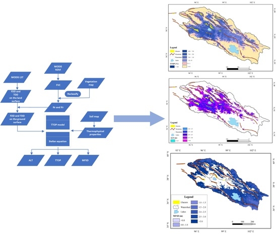
3.2. Spatial Distribution of TTOP
3.3. Spatial Distribution of ALT
3.4. Spatial Distribution of MFSD
4. Discussions
4.1. Comparisons to Published Permafrost Maps
4.2. Correlation between Permafrost and Topography
4.3. Response of Permafrost to Climate Change
5. Summary and Conclusions
Author Contributions
Funding
Institutional Review Board Statement
Informed Consent Statement
Data Availability Statement
Conflicts of Interest
References
- Everdingen, V. Multi-Language Glossary of Permafrost and Related Ground-Ice Terms; National Snow and Ice Data Center: Boulder, CO, USA, 2005; p. 90. [Google Scholar]
- Cheng, G. Problems on Zonation of High-Altitude Permafrost. Acta Geogr. Sin. 1984, 39, 185–193. [Google Scholar]
- Ran, Y.; Li, X.; Cheng, G. Climate warming over the past half century has led to thermal degradation of permafrost on the Qinghai–Tibet Plateau. Cryosphere 2018, 12, 595–608. [Google Scholar] [CrossRef]
- Wu, Q.; Zhang, T.; Liu, Y. Thermal state of the active layer and permafrost along the Qinghai-Xizang (Tibet) Railway from 2006 to 2010. Cryosphere 2012, 6, 607–612. [Google Scholar] [CrossRef]
- Luo, D.; Jin, H.; Jin, X.; He, R.; Li, X.; Muskett, R.R.; Marchenko, S.S.; Romanovsky, V.E. Elevation-dependent thermal regime and dynamics of frozen ground in the Bayan Har Mountains, northeastern Qinghai-Tibet Plateau, SW China. Permafr. Periglac. Process. 2018, 29, 257–270. [Google Scholar] [CrossRef]
- Wu, J.; Sheng, Y.; Yu, H.; Li, J. Permafrost in the middle-east section of Qilian Mountains (I): Distribution of permafrost. J. Glaciol. Geocryol. 2007, 29, 418–425. [Google Scholar]
- Wu, J.; Sheng, Y.; Yu, H.; Li, J. Permafrost in the middle-east section of Qilian Mountains (II): Characters of permafrost. J. Glaciol. Geocryol. 2007, 29, 426–432. [Google Scholar]
- Wu, J.; Sheng, Y.; Li, J.; Wang, J. Permafrost in Source Areas of Shule River in Qilian Mountains. Acta Geogr. Sin. 2009, 64, 571–580. [Google Scholar]
- Wang, S.; Sheng, Y.; Wu, J.; Li, J.; Chen, J. The characteristics and changing tendency of permafrost in the source regions of the Datong River, Qilian Mountains. J. Glaciol. Geocryol. 2015, 37, 27–37. [Google Scholar]
- Cheng, G.; Zhao, L.; Li, R.; Wu, X.; Sheng, Y.; Hu, G.; Zou, D.; Jin, H.; Li, X.; Wu, Q. Characteristic, changes and impacts of permafrost on Qinghai-Tibet Plateau. Chinese Sci. Bull. 2019, 64, 2783–2795. [Google Scholar] [CrossRef]
- Biskaborn, B.K.; Smith, S.L.; Noetzli, J.; Matthes, H.; Vieira, G.; Streletskiy, D.A.; Schoeneich, P.; Romanovsky, V.E.; Lewkowicz, A.G.; Abramov, A.; et al. Permafrost is warming at a global scale. Nat. Commun. 2019, 10, 264. [Google Scholar] [CrossRef]
- Wu, Q.; Hou, Y.; Yun, H.; Liu, Y. Changes in active-layer thickness and near-surface permafrost between 2002 and 2012 in alpine ecosystems, Qinghai–Xizang (Tibet) Plateau, China. Glob. Planet. Chang. 2015, 124, 149–155. [Google Scholar] [CrossRef]
- Cao, B.; Zhang, T.; Peng, X.; Mu, C.; Wang, Q.; Zheng, L.; Wang, K.; Zhong, X. Thermal Characteristics and Recent Changes of Permafrost in the Upper Reaches of the Heihe River Basin, Western China. J. Geophys. Res. Atmos. 2018, 123, 7935–7949. [Google Scholar] [CrossRef]
- Peng, X.; Zhang, T.; Frauenfeld, O.W.; Wang, S.; Qiao, L.; Du, R.; Mu, C. Northern Hemisphere greening in association with warming permafrost. J. Geophys. Res. Biogeosciences 2020, 125, 125. [Google Scholar] [CrossRef]
- Way, R.G.; Lewkowicz, A.G.; Zhang, Y. Characteristics and fate of isolated permafrost patches in coastal Labrador, Canada. Cryosphere 2018, 12, 2667–2688. [Google Scholar] [CrossRef]
- Way, R.G.; Lewkowicz, A.G. Environmental controls on ground temperature and permafrost in Labrador, northeast Canada. Permafr. Periglac. Process. 2018, 29, 73–85. [Google Scholar] [CrossRef]
- Nitzbon, J.; Westermann, S.; Langer, M.; Martin, L.C.P.; Strauss, J.; Laboor, S.; Boike, J. Fast response of cold ice-rich permafrost in northeast Siberia to a warming climate. Nat. Commun. 2020, 11, 2201. [Google Scholar] [CrossRef]
- Wang, T.; Yang, D.; Yang, Y.; Piao, S.; Li, X.; Cheng, G.; Fu, B. Permafrost thawing puts the frozen carbon at risk over the Tibetan Plateau. Sci. Adv. 2020, 6, eaaz3513. [Google Scholar] [CrossRef]
- Mu, C.; Schuster, P.F.; Abbott, B.W.; Kang, S.; Guo, J.; Sun, S.; Wu, Q.; Zhang, T. Permafrost degradation enhances the risk of mercury release on Qinghai-Tibetan Plateau. Sci. Total. Environ. 2020, 708, 135127. [Google Scholar] [CrossRef]
- Zhang, Z.; Wang, M.; Wu, Z.; Liu, X. Permafrost Deformation Monitoring Along the Qinghai-Tibet Plateau Engineering Corridor Using InSAR Observations with Multi-Sensor SAR Datasets from 1997–2018. Sensors 2019, 19, 5306. [Google Scholar] [CrossRef]
- Guo, D.; Yang, M.; Wang, H. Characteristics of land surface heat and water exchange under different soil freeze/thaw conditions over the central Tibetan Plateau. Hydrol. Process. 2011, 25, 2531–2541. [Google Scholar] [CrossRef]
- Stiegler, C.; Johansson, M.; Christensen, T.R.; Mastepanov, M.; Lindroth, A. Tundra permafrost thaw causes significant shifts in energy partitioning. Tellus B Chem. Phys. Meteorol. 2016, 68, 1. [Google Scholar] [CrossRef]
- Yao, T.; Thompson, L.; Yang, W.; Yu, W.; Gao, Y.; Guo, X.; Yang, X.; Duan, K.; Zhao, H.; Xu, B.; et al. Different glacier status with atmospheric circulations in Tibetan Plateau and surroundings. Nat. Clim. Chang. 2012, 2, 663–667. [Google Scholar] [CrossRef]
- Immerzeel, W.W.; Van Beek, L.P.; Bierkens, M.F. Climate change will affect the Asian water towers. Science 2010, 328, 1382–1385. [Google Scholar] [CrossRef] [PubMed]
- Xu, X.; Lu, C.; Shi, X.; Gao, S. World water tower: An atmospheric perspective. Geophys. Res. Lett. 2008, 35, 20815. [Google Scholar] [CrossRef]
- Yao, T.; Wu, G.; Xu, B.; Wang, W.; Gao, J.; An, B. Asian Water Tower Change and Its Impacts. Bull. Chin. Acad. Sci. 2019, 34, 1203–1209. [Google Scholar] [CrossRef]
- Zhao, S.; Cheng, W.; Zhou, C.; Chen, X.; Chen, J. Simulation of decadal alpine permafrost distributions in the Qilian Mountains over past 50 years by using Logistic Regression Model. Cold Reg. Sci. Technol. 2012, 73, 32–40. [Google Scholar] [CrossRef]
- Ran, Y.; Li, X.; Cheng, G.; Zhang, T.; Wu, Q.; Jin, H.; Jin, R. Distribution of Permafrost in China: An Overview of Existing Permafrost Maps. Permafr. Periglac. Process. 2012, 23, 322–333. [Google Scholar] [CrossRef]
- Li, S.; Cheng, G. Map of Permafrost on Qinghai-Tibetan Plateau (1:3,000,000); Gansu Culture Press: Lanzhou, China, 1996. [Google Scholar]
- Zhou, Y.; Qiu, G.; Guo, D.; Cheng, G.; Li, S. Geocryology in China; Science Press: Beijing, China, 2000; p. 450. [Google Scholar]
- Cheng, W.; Zhao, S.; Zhou, C.; Chen, X. Simulation of the Decadal Permafrost Distribution on the Qinghai-Tibet Plateau (China) over the Past 50 Years. Permafr. Periglac. Process. 2012, 23, 292–300. [Google Scholar] [CrossRef]
- Zhao, S.; Zhang, S.; Cheng, W.; Zhou, C. Model Simulation and Prediction of Decadal Mountain Permafrost Distribution Based on Remote Sensing Data in the Qilian Mountains from the 1990s to the 2040s. Remote Sens. 2019, 11, 183. [Google Scholar] [CrossRef]
- Guo, D.; Wang, H. Simulation of permafrost and seasonally frozen ground conditions on the Tibetan Plateau, 1981-2010. J. Geophys. Res. Atmos. 2013, 118, 5216–5230. [Google Scholar] [CrossRef]
- Wang, X.; Chen, R.; Han, C.; Yang, Y.; Liu, J.; Liu, Z.; Song, Y. Response of frozen ground under climate change in the Qilian Mountains, China. Quat. Int. 2019, 523, 10–15. [Google Scholar] [CrossRef]
- Li, X.; Gou, X.; Wang, N.; Sheng, Y.; Jin, H.; Qi, Y.; Song, X.; Hou, F.; Li, Y.; Zhao, C.; et al. Tightening ecological management facilitates green development in the Qilian Mountains. Chin. Sci. Bull. 2019, 64, 2928–2937. [Google Scholar] [CrossRef]
- Zhongqiong, Z.; Qingbai, W.; Guanli, J.; Siru, G.; Ji, C.; Yongzhi, L. Changes in the permafrost temperatures from 2003 to 2015 in the Qinghai-Tibet Plateau. Cold Reg. Sci. Technol. 2020, 169, 102904. [Google Scholar] [CrossRef]
- Liu, L.; Luo, D.; Wang, L.; Huang, Y.; Chen, F. Variability of soil freeze depth in association with climate change from 1901 to 2016 in the upper Brahmaputra River Basin, Tibetan Plateau. Theor. Appl. Clim. 2020, 142, 19–28. [Google Scholar] [CrossRef]
- Shi, Y.; Niu, F.; Lin, Z.; Luo, J. Freezing/thawing index variations over the circum-Arctic from 1901 to 2015 and the permafrost extent. Sci. Total. Environ. 2019, 660, 1294–1305. [Google Scholar] [CrossRef]
- Ran, Y.; Li, X.; Cheng, G.; Nan, Z.; Che, J.; Sheng, Y.; Wu, Q.; Jin, H.; Luo, D.; Tang, Z.; et al. Mapping the permafrost stability on the Tibetan Plateau for 2005–2015. Sci. China Earth Sci. 2020, 63, 1–18. [Google Scholar] [CrossRef]
- Wang, T.; Yang, D.; Fang, B.; Yang, W.; Qin, Y.; Wang, Y. Data-driven mapping of the spatial distribution and potential changes of frozen ground over the Tibetan Plateau. Sci. Total. Environ. 2019, 649, 515–525. [Google Scholar] [CrossRef]
- Gorelick, N.; Hancher, M.; Dixon, M.; Ilyushchenko, S.; Thau, D.; Moore, R. Google Earth Engine: Planetary-scale geospatial analysis for everyone. Remote Sens. Environ. 2017, 202, 18–27. [Google Scholar] [CrossRef]
- Shelestov, A.; Lavreniuk, M.; Kussul, N.; Novikov, A.; Skakun, S. Exploring Google Earth Engine Platform for Big Data Processing: Classification of Multi-Temporal Satellite Imagery for Crop Mapping. Front. Earth Sci. 2017, 5, 17. [Google Scholar] [CrossRef]
- Xiong, J.; Thenkabail, P.; Tilton, J.; Gumma, M.; Teluguntla, P.; Oliphant, A.; Congalton, R.; Yadav, K.; Gorelick, N. Nominal 30-m Cropland Extent Map of Continental Africa by Integrating Pixel-Based and Object-Based Algorithms Using Sentinel-2 and Landsat-8 Data on Google Earth Engine. Remote Sens. 2017, 9, 1065. [Google Scholar] [CrossRef]
- Chen, B.; Xiao, X.; Li, X.; Pan, L.; Doughty, R.; Ma, J.; Dong, J.; Qin, Y.; Zhao, B.; Wu, Z.; et al. A mangrove forest map of China in 2015: Analysis of time series Landsat 7/8 and Sentinel-1A imagery in Google Earth Engine cloud computing platform. ISPRS J. Photogramm. Remote Sens. 2017, 131, 104–120. [Google Scholar] [CrossRef]
- Mahdianpari, M.; Brisco, B.; Granger, J.E.; Mohammadimanesh, F.; Salehi, B.; Banks, S.; Homayouni, S.; Bourgeau-Chavez, L.; Weng, Q. The Second Generation Canadian Wetland Inventory Map at 10 Meters Resolution Using Google Earth Engine. Can. J. Remote Sens. 2020, 46, 360–375. [Google Scholar] [CrossRef]
- Patel, N.N.; Angiuli, E.; Gamba, P.; Gaughan, A.; Lisini, G.; Stevens, F.R.; Tatem, A.J.; Trianni, G. Multitemporal settlement and population mapping from Landsat using Google Earth Engine. Int. J. Appl. Earth Obs. Geoinformation 2015, 35, 199–208. [Google Scholar] [CrossRef]
- Luo, D.-L.; Jin, H.-J.; Du, H.-Q.; Li, C.; Ma, Q.; Duan, S.-Q.; Li, G.-S. Variation of alpine lakes from 1986 to 2019 in the Headwater Area of the Yellow River, Tibetan Plateau using Google Earth Engine. Adv. Clim. Chang. Res. 2020, 11, 11–21. [Google Scholar] [CrossRef]
- Donchyts, G.; Baart, F.; Winsemius, H.; Gorelick, N.; Kwadijk, J.; Van De Giesen, N. Earth’s surface water change over the past 30 years. Nat. Clim. Chang. 2016, 6, 810–813. [Google Scholar] [CrossRef]
- Wang, C.; Jia, M.; Chen, N.; Wang, W. Long-Term Surface Water Dynamics Analysis Based on Landsat Imagery and the Google Earth Engine Platform: A Case Study in the Middle Yangtze River Basin. Remote Sens. 2018, 10, 1635. [Google Scholar] [CrossRef]
- Lunardini, V.J. Theory of n-factors and correlation of data. In Proceedings of the Third International Conference on Permafrost, Edmonton, AB, Canada, 10–13 July 1978; pp. 40–46. [Google Scholar]
- Smith, M.W.; Riseborough, D.W. Permafrost monitoring and detection of climate change. Permafr. Periglac. Process. 1996, 7, 301–309. [Google Scholar] [CrossRef]
- Lunardini, V.J. Heat Transfer in Cold Climates; Van Nostrand Reinhold Company: New York, NY, USA, 1981. [Google Scholar]
- Zhang, G.; Yao, T.; Piao, S.; Bolch, T.; Xie, H.; Chen, D.; Gao, Y.; O’Reilly, C.M.; Shum, C.K.; Yang, K.; et al. Extensive and drastically different alpine lake changes on Asia’s high plateaus during the past four decades. Geophys. Res. Lett. 2017, 44, 252–260. [Google Scholar] [CrossRef]
- Cao, B.; Gruber, S.; Zhang, T.; Li, L.; Peng, X.; Wang, K.; Zheng, L.; Shao, W.; Guo, H. Spatial variability of active layer thickness detected by ground-penetrating radar in the Qilian Mountains, Western China. J. Geophys. Res. Earth Surf. 2017, 122, 574–591. [Google Scholar] [CrossRef]
- Wang, Q.; Zhang, T.; Wu, J.; Peng, X.; Zhong, X.; Mu, C.; Wang, K.; Wu, Q.; Cheng, G. Investigation on permafrost distribution over the upper reaches of the Heihe River in the Qilian Mountains. J. Glaciol. Geocryol. 2013, 35, 19–29. [Google Scholar]
- Wang, Q.; Jin, H.; Zhang, T.; Cao, B.; Peng, X.; Wang, K.; Xiao, X.; Guo, H.; Mu, C.; Li, L. Hydro-thermal processes and thermal offsets of peat soils in the active layer in an alpine permafrost region, NE Qinghai-Tibet plateau. Glob. Planet. Chang. 2017, 156, 1–12. [Google Scholar] [CrossRef]
- Chen, G.; Peng, M.; Huang, R.; Lu, X. Vegetation characteristics and its distribution of Qilian Mountain region. Acta Bot. Sin. 1994, 36, 63–72. [Google Scholar]
- Li, J.; Sheng, Y.; Chen, J.; Zhang, B.; Wu, J.; Zhang, X. Characteristics of ground temperatures and influencing factors of permafrost development and distribution in the Source Region of Datong River. Prog. Geogr. 2011, 30, 827–836. [Google Scholar]
- Qin, Y.; Lei, H.; Yang, D.; Gao, B.; Wang, Y.; Cong, Z.; Fan, W. Long-term change in the depth of seasonally frozen ground and its ecohydrological impacts in the Qilian Mountains, northeastern Tibetan Plateau. J. Hydrol. 2016, 542, 204–221. [Google Scholar] [CrossRef]
- Zhao, L.; Zou, D.; Hu, G.; Du, E.; Pang, Q.; Xiao, Y.; Li, R.; Sheng, Y.; Wu, X.; Sun, Z.; et al. Changing climate and the permafrost environment on the Qinghai–Tibet (Xizang) plateau. Permafr. Periglac. Process. 2020, 31, 396–405. [Google Scholar] [CrossRef]
- Mu, C.; Shang, J.; Zhang, T.; Fan, C.; Wang, S.; Peng, X.; Zhong, W.; Zhang, F.; Mu, M.; Jia, L. Acceleration of thaw slump during 1997–2017 in the Qilian Mountains of the northern Qinghai-Tibetan plateau. Landslides 2020, 17, 1051–1062. [Google Scholar] [CrossRef]
- Li, J.; Sheng, Y.; Chen, J.; Zhang, B.; Wu, J.; Zhang, X. Modeling permafrost temperature distribution and analyzing zoning characteristics of permafrost in the source region of the Datong River. J. China Univ. Min. Technol. 2012, 41, 145–152. [Google Scholar]
- Li, J.; Sheng, Y.; Wu, J.; Wang, J.; Zhang, B.; Ye, B.; Zhang, X.; Qin, X. Application of the equivalent-elevation approach to alpine permafrost distribution models in the upper reaches of the Shule River, Qilian Mountains. J. Glaciol. Geocryol. 2011, 33, 357–363. [Google Scholar]
- Xu, X.; Wang, J.; Zhang, L. Physics of Frozen Soil; Science Publish House: Beijing, China, 2010; p. 351. [Google Scholar]
- Shi, X.; Yu, D.; Warner, E.; Pan, X.; Petersen, G.; Gong, Z.; Weindorf, D. Soil database of 1:1,000,000 digital soil survey and reference system of the Chinese genetic soil classification system. Soil Horizons 2004, 45, 129–136. [Google Scholar] [CrossRef]
- Smith, M.W.; Riseborough, D.W. Climate and the limits of permafrost: A zonal analysis. Permafr. Periglac. Process. 2002, 13, 1–15. [Google Scholar] [CrossRef]
- Riseborough, D.; Shiklomanov, N.; Etzelmuller, B.; Gruber, S.; Marchenko, S. Recent advances in permafrost modelling. Permafr. Periglac. Process. 2008, 19, 137–156. [Google Scholar] [CrossRef]
- Romanovsky, V.E.; Osterkamp, T.E. Interannual variations of the thermal regime of the active layer and near-surface permafrost in northern Alaska. Permafr. Periglac. Process. 1995, 6, 313–335. [Google Scholar] [CrossRef]
- Ran, Y.; Li, X.; Jin, R.; Guo, J. Remote Sensing of the Mean Annual Surface Temperature and Surface Frost Number for Mapping Permafrost in China. Arctic Antarct. Alp. Res. 2015, 47, 255–265. [Google Scholar] [CrossRef]
- Ghafarian Malamiri, H.; Rousta, I.; Olafsson, H.; Zare, H.; Zhang, H. Gap-Filling of MODIS Time Series Land Surface Temperature (LST) Products Using Singular Spectrum Analysis (SSA). Atmosphere 2018, 9, 334. [Google Scholar] [CrossRef]
- Zou, D.; Zhao, L.; Sheng, Y.; Chen, J.; Hu, G.; Wu, T.; Wu, J.; Xie, C.; Wu, X.; Pang, Q.; et al. A new map of permafrost distribution on the Tibetan Plateau. Cryosphere 2017, 11, 2527–2542. [Google Scholar] [CrossRef]
- Luo, D.; Liu, L.; Jin, H.; Wang, X.; Chen, F. Characteristics of ground surface temperature at Chalaping in the Source Area of the Yellow River, northeastern Tibetan Plateau. Agric. For. Meteorol. 2020, 281, 107819. [Google Scholar] [CrossRef]
- Luo, D.L.; Jin, H.J.; He, R.X.; Wang, X.F.; Muskett, R.R.; Marchenko, S.S.; Romanovsky, V.E. Characteristics of water-heat exchanges and inconsistent surface temperature changes at an elevational permafrost site on the Qinghai-Tibet Plateau. J. Geophys. Res. Atmos. 2018, 123, 10057–10075. [Google Scholar] [CrossRef]
- Luo, D.; Jin, H.; Marchenko, S.S.; Romanovsky, V.E. Difference between near-surface air, land surface and ground surface temperatures and their influences on the frozen ground on the Qinghai-Tibet Plateau. Geoderma 2018, 312, 74–85. [Google Scholar] [CrossRef]
- Yin, G.; Niu, F.; Lin, Z.; Luo, J.; Liu, M. Effects of local factors and climate on permafrost conditions and distribution in Beiluhe basin, Qinghai-Tibet Plateau, China. Sci. Total. Environ. 2017, 581-582, 472–485. [Google Scholar] [CrossRef]
- Klene, A.E.; Nelson, F.E.; Shiklomanov, N.I.; Hinkel, K.M. The N-factor in Natural Landscapes: Variability of Air and Soil-Surface Temperatures, Kuparuk River Basin, Alaska, U.S.A. Arctic Antarct. Alp. Res. 2001, 33, 140–148. [Google Scholar] [CrossRef]
- Luo, D.; Jin, H.; Wu, Q.; Bense, V.F.; He, R.; Ma, Q.; Gao, S.; Jin, X.; Lu, L. Thermal regime of warm-dry permafrost in relation to ground surface temperature in the Source Areas of the Yangtze and Yellow rivers on the Qinghai-Tibet Plateau, SW China. Sci. Total. Environ. 2018, 618, 1033–1045. [Google Scholar] [CrossRef] [PubMed]
- Li, M.; Wu, B.; Yan, C.; Zhou, W. Estimation of Vegetation Fraction in the Upper Basin of Miyun Reservoir by Remote Sensing. Resour. Sci. 2004, 26, 153–159. [Google Scholar]
- Willmott, C.J.; Matsuura, K. Advantages of the mean absolute error (MAE) over the root mean square error (RMSE) in assessing average model performance. Clim. Res. 2005, 30, 79–82. [Google Scholar] [CrossRef]
- Gruber, S. Derivation and analysis of a high-resolution estimate of global permafrost zonation. Cryosphere 2012, 6, 221–233. [Google Scholar] [CrossRef]
- Obu, J.; Westermann, S.; Bartsch, A.; Berdnikov, N.; Christiansen, H.H.; Dashtseren, A.; Delaloye, R.; Elberling, B.; Etzelmüller, B.; Kholodov, A.; et al. Northern Hemisphere permafrost map based on TTOP modelling for 2000–2016 at 1km2 scale. Earth-Sci. Rev. 2019, 193, 299–316. [Google Scholar] [CrossRef]
- Yan, D.; Wünnemann, B. Late Quaternary water depth changes in Hala Lake, northeastern Tibetan Plateau, derived from ostracod assemblages and sediment properties in multiple sediment records. Quat. Sci. Rev. 2014, 95, 95–114. [Google Scholar] [CrossRef]
- Karunaratne, K.; Burn, C. Freezing n-factors in discontinuous permafrost terrain, Takhini River, Yukon Territory, Canada. In Proceedings of the 8th International Conference on Permafrost, Zurich, Switzerland, 21–25 July 2003; University of Zurich: Irchel, Switzerland, 2003; pp. 519–524. [Google Scholar]
- Jin, H.; Luo, D.; Wang, S.; Lü, L.; Wu, J. Spatiotemporal variability of permafrsot degradation on the Qinghai-Tibet Plateau. Sci. Cold Arid Reg. 2011, 3, 281–305. [Google Scholar] [CrossRef]
- French, H.M. The Periglacial Environment, 4th ed.; John Wiley & Sons Ltd: Hoboken, NJ, USA, 2018; p. 515. [Google Scholar]
- Nan, Z.; Gao, Z.; Li, S.; Wu, T. Permafrost changes in the northern limit of permafrost on the Qinghai-Tibet Plateau in the last 30 years. Acta Geogr. Sin. 2003, 58, 817–823. [Google Scholar]
- Harris, S.A.; Brouchkov, A.; Guodong, C. Geocryology: An. Introduction to Frozen Ground, 1st ed.; CRC Press: Boca Raton, FL, USA, 2018; p. 810. [Google Scholar]
- Wang, S.; Chen, X.; Zhang, Z. Permafrost distribution in the Dabanshan Pass Section of Ning-Zhang highway in Eastern Qilian Mountains. J. Glaciol. Geocryol. 1995, 17, 184–188. [Google Scholar]
- Cheng, G.; Dramis, F. Distribution of mountain permafrost and climate. Permafr. Periglac. Process. 1992, 3, 83–91. [Google Scholar] [CrossRef]


| GPF–TTOP(km2) | NPD–TTOP (km2) | TTOP–GPF (km2) | TTOP–NPD (km2) | |
|---|---|---|---|---|
| Difference | 17,961.2 | 8556.7 | 1906.3 | 9460.7 |
| Difference/TTOP (%) | 9.86% | 4.70% | 1.05% | 5.19% |
| NTP_TP | GlobalPF | |||||
|---|---|---|---|---|---|---|
| 0 | 1 | Sum | 0 | 1 | Sum | |
| 0 | 69,910 | 8797 | 78,707 | 96,407 | 22,990 | 119,397 |
| 1 | 6562 | 78,042 | 84,604 | 1956 | 103,236 | 105,192 |
| Sum | 76,472 | 86,839 | 163,311 | 98,363 | 126,226 | 224,589 |
| Kappa | 0.811 | 0.780 | ||||
Publisher’s Note: MDPI stays neutral with regard to jurisdictional claims in published maps and institutional affiliations. |
© 2021 by the authors. Licensee MDPI, Basel, Switzerland. This article is an open access article distributed under the terms and conditions of the Creative Commons Attribution (CC BY) license (http://creativecommons.org/licenses/by/4.0/).
Share and Cite
Qi, Y.; Li, S.; Ran, Y.; Wang, H.; Wu, J.; Lian, X.; Luo, D. Mapping Frozen Ground in the Qilian Mountains in 2004–2019 Using Google Earth Engine Cloud Computing. Remote Sens. 2021, 13, 149. https://doi.org/10.3390/rs13010149
Qi Y, Li S, Ran Y, Wang H, Wu J, Lian X, Luo D. Mapping Frozen Ground in the Qilian Mountains in 2004–2019 Using Google Earth Engine Cloud Computing. Remote Sensing. 2021; 13(1):149. https://doi.org/10.3390/rs13010149
Chicago/Turabian StyleQi, Yuan, Shiwei Li, Youhua Ran, Hongwei Wang, Jichun Wu, Xihong Lian, and Dongliang Luo. 2021. "Mapping Frozen Ground in the Qilian Mountains in 2004–2019 Using Google Earth Engine Cloud Computing" Remote Sensing 13, no. 1: 149. https://doi.org/10.3390/rs13010149
APA StyleQi, Y., Li, S., Ran, Y., Wang, H., Wu, J., Lian, X., & Luo, D. (2021). Mapping Frozen Ground in the Qilian Mountains in 2004–2019 Using Google Earth Engine Cloud Computing. Remote Sensing, 13(1), 149. https://doi.org/10.3390/rs13010149