
An Integrated Remote-Sensing and GIS Approach for Mapping Past Tin Mining Landscapes in Northwest Iberia

 ,
,  ,
,  ,
,  , , and
Abstract
:1. Introduction
2. Materials and Methods
2.1. Airborne Light Detection and Ranging (LiDAR)
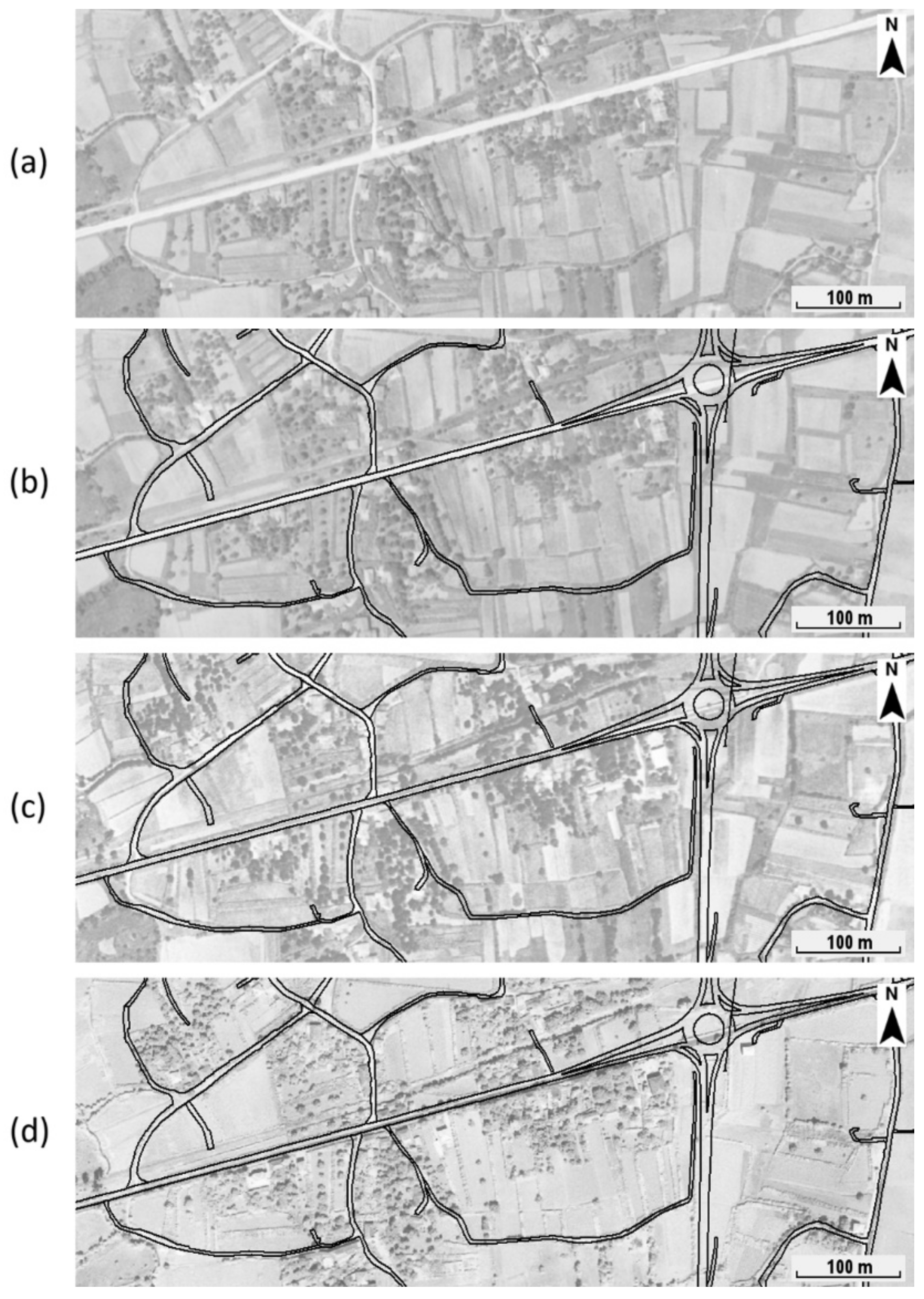
2.2. Archival Aerial Imagery
2.3. Archival Maps and Documents
2.4. Geological Sample Collection, Preparation, and Analysis
3. Geological Context
4. Results
4.1. Characterisation of Modern Mining According to the Documentation of Mining Archives
4.2. Mapping of Mining Works
4.2.1. Sapeiras
4.2.2. Zolas
4.2.3. Rasas
5. Discussion
5.1. Typo-Morphological Classification of Mining Works
5.2. The Question of Water Supply
5.3. Historical Implications
6. Conclusions
Author Contributions
Funding
Data Availability Statement
Acknowledgments
Conflicts of Interest
References
- Comendador Rey, B.; Meunier, E.; Figueiredo, E.; Lackinger, A.; Fonte, J.; Fernández Fernández, C.; Lima, A.; Mirão, J.; Silva, R.J.C. Northwestern Iberian tin mining from bronze age to modern times: An overview. In The Tinworking Landscape of Dartmoor in a European Context; Newman, P., Ed.; Dartmoor Tinworking Research Group: Sowton, UK, 2017; pp. 133–153. [Google Scholar]
- Meunier, E. El estaño del Noroeste ibérico desde la Edad del Bronce hasta la época romana. Por una primera síntesis. In La ruta de las Estrímnides: Navegación y Conocimiento del Litoral Atlántico de Iberia en la Antigüedad; Ferrer Albelda, E., Ed.; Monografías de Gahia; Universidad de Alcalá: Sevilla, Spain, 2019; pp. 280–320. [Google Scholar]
- Domergue, C.; Hérail, G. Mines d’Or Romaines d’Espagne: Le District de la Valduerna (León); Université de Toulouse-Le Mirail: Toulouse, France, 1978. [Google Scholar]
- Domergue, C. Les Mines de la Péninsule Ibérique dans l’Antiquité Romaine; École Française de Rome: Rome, Italy, 1990; Volume 127. [Google Scholar]
- Sánchez-Palencia, F.J.; Vaudagna, A.; Pecharromán, J.L.; Beltrán, A.; Currás, B.; Alonso, F.; Ruiz del Árbol, M. La zona minera de la Bessa (Biella, Italia) como precedente republicano de la minería del oro en Hispania. In Arqueología, Sociedad, Territorio y Paisaje: Estudios Sobre Prehistoria Reciente, Protohistoria y Transición al Mundo Romano en Homenaje a Mª Dolores Fernández Posse; Bueno, P., Gilman, A., Martín Morales, C., Sánchez-Palencia, F.J., Eds.; Bibliotheca Praehistorica Hispania: Madrid, Spain; CSIC: Madrid, Spain, 2011; pp. 329–347. [Google Scholar]
- Currás, B.; Ruiz del Árbol, M.; Sánchez-Palencia, F.J.; Orejas, A.; Romero, D. Ancient landscapes of north-western Iberia: Historical aerial photographs and the interpretation of Iron Age and Roman territories. In Revovering Lost Landscapes; Ivanišević, V., Veljanovski, T., Cowley, D., Kiarszys, G., Bugarski, I., Eds.; Institute of Archaeology: Belgrade, Serbia, 2015; pp. 67–68. [Google Scholar]
- Cauuet, B.; Boussicault, M. Apport du Lidar à l’étude des mines d’étain antiques en dépôts secondaires autour d’Autun (71). Bull. Archéologique d’Autun 2015, 31–33. [Google Scholar]
- Fernández-Lozano, J.; Carrasco, R.M.; Pedraza, J.; Bernardo-Sánchez, A. The anthropic landscape imprint around one of the largest Roman hydraulic gold mines in Europe: Sierra del Teleno (NW Spain). Geomorphology 2020, 357, 107094. [Google Scholar] [CrossRef]
- Fernández-Lozano, J.; Gutiérrez-Alonso, G.; Fernández-Morán, M.A. Using airborne LiDAR sensing technology and aerial orthoimages to unravel roman water supply systems and gold works in NW Spain (Eria valley, León). J. Archaeol. Sci. 2015, 53, 356–373. [Google Scholar] [CrossRef]
- Fernández-Lozano, J.; Gutiérrez-Alonso, G. Improving archaeological prospection using localized UAVs assisted photogrammetry: An example from the Roman Gold District of the Eria River Valley (NW Spain). J. Archaeol. Sci. Rep. 2016, 5, 509–520. [Google Scholar] [CrossRef]
- Fernández-Lozano, J.; Palao-Vicente, J.J.; Blanco-Sánchez, J.A.; Gutiérrez-Alonso, G.; Remondo, J.; Bonachea, J.; Morellón, M.; González-Díez, A. Gold-bearing Plio-Quaternary deposits: Insights from airborne LiDAR technology into the landscape evolution during the early Roman mining works in north-west Spain. J. Archaeol. Sci. Rep. 2019, 24, 843–855. [Google Scholar] [CrossRef]
- Fonte, J.; Pires, H.; Gonçalves-Seco, L.; Matías Rodríguez, R.; Lima, A. Archaeological research of ancient mining landscapes in Galicia (Spain) using Airborne Laser Scanning data. In Actas do Simpósio Internacional Paisagens Mineiras Antigas na Europa Ocidental: Investigação e Valorização Cultural; Fontes, L., Martins, C., Eds.; Câmara Municipal de Boticas: Boticas, Portugal, 2014; p. 198. [Google Scholar]
- Matías, R.; Llamas, B. Use of LIDAR and photointerpretation to map the water supply at the Las Murias-Los Tallares Roman gold mine (Castrocontrigo, León, Spain). Archaeol. Prospect. 2018, 25, 59–69. [Google Scholar] [CrossRef]
- Matías, R.; Llamas, B. Analysis using LIDAR and photointerpretation of Las Murias-Los Tallares (Castrocontrigo, León-Spain): One of the biggest Roman gold mines to use the “Peines” system. Geoheritage 2019, 11, 381–397. [Google Scholar] [CrossRef]
- Matías, R.; Llamas, B. Roman gold mining at “Las Miédolas” (NW Spain): Lidar and photo interpretation in the analysis of “Peines” system. Geoheritage 2021, 13, 29. [Google Scholar] [CrossRef]
- Almeida, C.A.B. Proto-Historia e Romanização da Bacia Inferior do Lima; Faculdade de Letras do Porto: Porto, Portugal, 1990. [Google Scholar]
- Moreira, M.A.F. As “Arrugiae” da época romana no vale do rio Tinto do concelho de Viana do Castelo. In I Colóquio Galaico-Minhoto; Galaico-Minhota, A.C., Ed.; Câmara Municipal de Ponte de Lima: Ponte de Lima, Portugal, 1981; Volume II, pp. 395–423. [Google Scholar]
- Moreira, M.A.F. A Romanização do litoral do Alto Minho. Caminiana 1982, VI, 31–96. [Google Scholar]
- Alves, R. Contribuição para um Sistema de Gestão Integrada de Sítios Mineiros do NW de Portugal. Ph.D. Thesis, Universidade do Minho, Braga, Portugal, 2014. [Google Scholar]
- Servicios Politécnicos Aéreos (SPASA). Voo LiDAR: Proposta Metodológica; Servicios Politécnicos Aéreos: Madrid, Spain, 2018. [Google Scholar]
- Servicios Politécnicos Aéreos (SPASA). Relatório de Voo Combinado LiDAR e Foto; Servicios Politécnicos Aéreos: Madrid, Spain, 2018. [Google Scholar]
- Lozić, E.; Štular, B. Documentation of archaeology-specific workflow for airborne LiDAR data processing. Geosciences 2021, 11, 26. [Google Scholar] [CrossRef]
- Hesse, R. LiDAR-derived local relief models—A new tool for archaeological prospection. Archaeol. Prospect. 2010, 17, 67–72. [Google Scholar] [CrossRef]
- Kokalj, Ž.; Somrak, M. Why not a single image? Combining visualizations to facilitate fieldwork and on-screen mapping. Remote Sens. 2019, 11, 747. [Google Scholar] [CrossRef] [Green Version]
- Zakšek, K.; Oštir, K.; Kokalj, Ž. Sky-view factor as a relief visualization technique. Remote Sens. 2011, 3, 398–415. [Google Scholar] [CrossRef] [Green Version]
- Boehner, J.; Koethe, R.; Conrad, O.; Gross, J.; Ringeler, A.; Selige, T. Soil regionalisation by means of terrain analysis and process parameterisation. In Soil Classification 2001; Micheli, E., Nachtergaele, F., Montanarella, L., Eds.; Research Report; European Soil Bureau: Luxembourg, 2002; pp. 213–222. [Google Scholar]
- Boehner, J.; Selige, T. Spatial prediction of soil attributes using terrain analysis and climate regionalisation. In SAGA—Analysis and Modelling Applications; Boehner, J., Mc Cloy, K.R., Strobl, J., Eds.; Goettinger Geographische Abhandlungen: Goettingen, Germany, 2006; pp. 13–28. [Google Scholar]
- BergWerkGIS. VoGIS-Profil-Tool. Available online: https://github.com/BergWerkGIS/VoGIS-Profil-Tool/ (accessed on 20 August 2021).
- Redweik, P.; Roque, D.; Marques, A.; Matildes, R.; Marques, F. Triangulating the past—Recovering Portugal’s aerial images repository. Photogramm. Eng. Remote Sens. 2010, 9, 1007–1018. [Google Scholar] [CrossRef]
- Karara, H.M.; Abdel-Aziz, Y.I. Accuracy aspects of non-metric imageries. Photogramm. Eng. Remote Sens. 1974, 40, 1107–1117. [Google Scholar]
- Pinto, A.T.; Gonçalves, J.A.; Beja, P.; Pradinho Honrado, J. From archived historical aerial imagery to informative orthophotos: A framework for retrieving the past in long-term socioecological research. Remote Sens. 2019, 11, 1388. [Google Scholar] [CrossRef] [Green Version]
- Gonçalves, J.A. Automatic orientation and mosaicking of archived aerial photography using structure from motion. Int. Arch. Photogramm. Remote Sens. Spat. Inf. Sci. 2016, XL-3/W4, 123–126. [Google Scholar] [CrossRef] [Green Version]
- Blanco-Rotea, R.; Costa-García, J.M.; Fonte, J.; Gago Mariño, M.; Gonçalves, J.A. A Modern Age redoubt in a possible Roman camp. The relationship between two defensive models in Campos (Vila Nova de Cerveira, Minho Valley, Portugal). J. Archaeol. Sci. Rep. 2016, 10, 293–308. [Google Scholar] [CrossRef]
- Fonte, J.; Costa-García, J.M. Alto da Cerca (Valpaços, Portugal): Um assentamento militar romano na Serra da Padrela e sua relação com o distrito mineiro de Tresminas. Estudos do Quaternário 2016, 15, 39–58. [Google Scholar] [CrossRef]
- Fonte, J.; Lima, A.; Matías Rodríguez, R.; Gonçalves, J.A.; Leal, S. Novas evidências de mineração aurífera e estanhífera de época romana no alto vale do Tâmega (Montalegre e Boticas, norte de Portugal). Estudos do Quaternário 2017, 17, 45–55. [Google Scholar] [CrossRef] [Green Version]
- Fonte, J.; Pimenta, J.; Pereira, C.; Arruda, A.M. Revisitando os Chões de Alpompé com técnicas de deteção remota: Novas evidências sobre os sistemas defensivos Romano-Republicanos. Cuadernos de Prehistoria y Arqueología 2020, 46, 215–238. [Google Scholar] [CrossRef]
- Potere, D. Horizontal positional accuracy of Google Earth’s high-resolution imagery archive. Sensors 2008, 8, 7973–7981. [Google Scholar] [CrossRef]
- Amorim, A.B.C.; Freitas, J.A.G. O arquivo das minas do Norte de Portugal (1839–2011). Construção do arquivo digital de informações. Boletim de Minas 2015, 50, 75–92. [Google Scholar]
- Caetano Alves, M.I. Terraços fluviais do Alto Minho: Bacia do rio Lima e depósitos de Alvarães. Memória do Museu e Laboratório Mineralógico e Geológico 1995, 4, 395–399. [Google Scholar]
- Caetano Alves, M.I.; Insua Pereira, D. A sedimentação e a gliptogénese no registo cenozóico continental do Minho (NW Portugal). Ciências da Terra UNL 2000, 14, 99–110. [Google Scholar]
- Leal Gomes, C. Estudo Estrutural e Paragenético de um Sistema Pegmatóide Granítico—O Campo Filoniano de Arga—Minho (Portugal). Ph.D. Thesis, Universidade do Minho, Braga, Portugal, 1994. [Google Scholar]
- Rodríguez Fernández, L.R.; López Olmedo, F.; Oliveira, J.T.; Medialdea, T.; Terrinha, P.; Matas, J.; Martín-Serrano, A.; Martín Parra, L.M.; Rubio, F.; Marín, C.; et al. Mapa Geológico de la Península Ibérica, Baleares y Canarias a Escala 1/1.000.000. 2015. ©Instituto Geológico y Minero de España (IGME); ©Laboratório Nacional de Energia e Geologia (LNEG). Available online: https://info.igme.es/cartografiadigital/geologica/ (accessed on 29 January 2021).
- Caetano Alves, M.I. Análise dimensional de sedimentos fluviais: Formação de Alvarães e depósitos de terraços da bacia do rio Lima (NW de Portugal). Estudos do Quaternário 1999, 2, 65–72. [Google Scholar] [CrossRef]
- Caetano Alves, M.I. Alves, M.I. A sedimentação Fluvial Cenozóica na região do Minho (Portugal). In Encontros Sobre a Geomorfologia do Noroeste Peninsular; Faculdade de Letras da Universidade do Porto, Gedes: Porto, Portugal, 2002; pp. 19–21. [Google Scholar]
- Teixeira, C.; Medeiros, A.C.; Coelho, A.P. Noticia Explicativa da Folha 5-A Viana do Castelo; Serviços Geológicos de Portugal: Lisboa, Portugal, 1972. [Google Scholar]
- Machado, J.V.; (Mining engineer of Circunscrição mineira do Norte, Porto, Portugal). Dossier n.º 2946. Mina de Estanho, Denominada Cobalto N.º 2, Concessionada à Mineira Estrela de Rocha, Lda, Freguesia Vila Mou, Concelho Viana do Castelo, Unpublished report. 1954.
- Machado, J.V.; (Mining engineer of Circunscrição mineira do Norte, Porto, Portugal). Dossier n.º 3238. Mina de Estanho, Denominada Cruz de Lenta, Concessionada à Mineira Estrela de Rocha, Lda, Freguesia Meixedo, Concelho Viana do Castelo, Unpublished report. 1958.
- Machado, J.V.; (Mining engineer of Circunscrição mineira do Norte, Porto, Portugal). Dossier n.º 3239. Mina de Estanho, Denominada Balteiro N.º1, Concessionada à Mineira Estrela de Rocha, Lda, Freguesia Meixedo, Concelho Viana do Castelo, Unpublished report. 1958.
- Anonymous; (Chief mining engineer of Circunscrição mineira do Norte, Porto, Portugal). Alto da Bouça da Breia, Unpublished report. 1955.
- Sánchez-Palencia, F.J. La zona minera de Penamacor-Meimoa (Castelo Branco). In Minería Romana en Zonas Interfronterizas de Castilla y León y Portugal; Sánchez-Palencia, F.J., Ed.; Junta de Castilla y León: León, Spain, 2014; pp. 103–133. [Google Scholar]
- Domergue, C. Les Mines Antiques; Picard: Paris, France, 2008. [Google Scholar]
- Cauuet, B.; Tamas, C.-G. Les travaux miniers antiques de Rosia Montana (Roumanie). Apports croisés entre archéologie et géologie. In Minería y Metalurgia Antiguas: Visiones y Revisiones. Homenaje a Claude Domergue; Orejas, A., Rico, C., Eds.; Collection de la Casa de Velázquez; Casa de Velázquez: Madrid, Spain, 2012. [Google Scholar]
- Fabre, J.-M.; Meunier, E.; Souhassou, M.; Rico, C.; Antolinos Marín, J.A. La mina romana de plomo argentífero de la Rambla del Abenque (Sierra Minera de Cartagena): Morfología de los trabajos de extracción, tipos de mineralización y cronología de la explotación. In Presente y Futuro de los Paisajes Mineros del Pasado: Estudios Sobre Minería, Metalurgia y Poblamiento; García Pulido, L., Arboledas Martínez, L., Alarcón García, E., Contreras Cortés, F., Eds.; Editorial Universidad de Granada: Granada, Spain, 2017; pp. 131–139. [Google Scholar]
- Tolksdorf, J.F.; Schröder, F.; Petr, L.; Herbig, C.; Kaiser, K.; Kočár, P.; Fülling, A.; Heinrich, S.; Hönig, H.; Hemker, C. Evidence for Bronze Age and Medieval tin placer mining in the Erzgebirge mountains, Saxony (Germany). Geoarchaeol. Int. J. 2019, 35, 198–216. [Google Scholar] [CrossRef]
- Dessolin, T.; Cauuet, B. Les anciennes mines d’étain de l’Autunois: Actualité des recherches. Bull. Archéologique d’Autun 2018, 2018, 47–59. [Google Scholar]
- Cauuet, B.; Tamas, C.-G.; Boussicault, M. Le district stannifère d’Autun. Les Dossiers d’Archéologie 2006, 316, 26–27. [Google Scholar]
- García Pulido, L.J. La minería hidráulica romana desarrollada en el Cerro del Sol (Granada) para explotar sus recursos auríferos. Cuadernos de la Alhambra 2008, 43, 76–101. [Google Scholar]
- Sánchez-Palencia Ramos, F.J.; Orejas Saco del Valle, A.; Sastre Prats, I.; Pérez, L.C. Las zonas mineras romanas del Noroeste peninsular. Infraestructura y organización del territorio. In Nuevos Elementos de Ingeniería Romana, Proceedings of the III Congreso de las Obras Públicas Romanas, Astorga, Spain, 5–7 October 2006; Moreno Galli, I., Ed.; Junta de Castilla y León: León, Spain; Consejería de Cultura y Turismo: Madrid, Spain, 2006; pp. 265–285. [Google Scholar]
- Hirt, A.M. Imperial Mines and Quarries in the Roman World: Organizational Aspects 27 BC–AD 235; Oxford University Press: Oxford, UK, 2010. [Google Scholar]
- Gianotti, F. Geological setting of the Pleistocene placers and roman gold mines of the Ivrea Morainic Amphitheatre (Piedmont, NW Italy). Ital. J. Quat. Sci. 2011, 24, 183–185. [Google Scholar]
- Sánchez-Palencia, F.J.; Vaudagna, A.; Pecharromán, J.L.; Iriarte, E. La Minería Romana de Oro en Italia: La Bessa (Biella) Como Precedente Republicano de la Minería en Hispania. Informes y Trabajos. Excavaciones en el Exterior 2012; Ministerio de Educación, Cultura y Deportes: Madrid, Spain, 2014; Volume 11, pp. 55–72.
- Bannon, C. Fresh water in Roman law: Rights and policy. J. Rom. Stud. 2017, 107, 60–89. [Google Scholar] [CrossRef] [Green Version]
- Figueiredo, E.; Fonte, J.; Lima, A.; Veiga, J.P.; Silva, R.J.C.; Mirão, J. Ancient tin production: Slags from the Iron Age Carvalhelhos hillfort (NW Iberian Peninsula). J. Archaeol. Sci. 2018, 93, 1–16. [Google Scholar] [CrossRef] [Green Version]


| Set of Photos | Year | No. of Photos | Scanning Resolution (dpi) | Average GSD (m) |
|---|---|---|---|---|
| SPLAL | 1949 | 10 | 1210 | 0.43 |
| USAF | 1958 | 3 | 1210 | 0.59 |
| DGT | 1965 | 4 | 800 | 0.58 |
| Element (%) | Sapeiras Panned Sediments | Rasas (Peg) Panned Sediments | Rasas (Clay) Panned Sediments | Zolas Panned Sediments |
|---|---|---|---|---|
| Sn | 0.07 | 0.35 | 0.19 | 0.32 |
| Fe | 0.68 | 0.33 | 2.14 | 2.03 |
| SiO2 | 48.4 | 47.3 | 33.9 | 2.01 |
| Mn | 0.03 | 0.20 | 0.66 | - |
| Nb | 0.01 | 0.11 | - | 0.05 |
| Ta | - | 0.06 | - | - |
| Zr | 0.12 | 0.01 | - | 0.07 |
| Zn | 0.06 | - | 0.06 | 0.02 |
| Ti | 0.69 | - | 0.07 | 0.12 |
| Pb | - | - | 0.06 | - |
| V | - | - | - | 0.02 |
| K2O | 0.26 | 0.98 | 0.52 | 0.11 |
| Ba | - | - | 0.14 | - |
| Rb | - | 0.02 | - | <0.01 |
| Al2O3 | 1.21 | 5.41 | 2.77 | |
| S | 0.04 | - | - | - |
| Ca | - | 0.02 | - | - |
| Hf | <0.01 | - | - | - |
| Element (%) | Sapeiras Selected Grains | Rasas (Peg) Selected Grains | Rasas (Clay) Selected Grains |
|---|---|---|---|
| Sn | 15.4 | 11.8 | 11.8 |
| Fe | 1.52 | 0.91 | 12.2 |
| SiO2 | 1.16 | 3.22 | 1.63 |
| Mn | 0.01 | 4.83 | 3.57 |
| Nb | 0.15 | 0.06 | 0.09 |
| Ta | - | - | 0.13 |
| Zr | 0.01 | - | <0.01 |
| Zn | 4.18 | 1.25 | 0.05 |
| Cu | 0.01 | 0.12 | - |
| Pb | - | 0.31 | 0.34 |
| Ga | 0.03 | - | - |
| K2O | - | 0.15 | 0.17 |
| Ba | - | 0.69 | 0.65 |
| Rb | - | 0.01 | 0.02 |
| Co | - | 0.22 | - |
| Sr | - | - | 0.01 |
Publisher’s Note: MDPI stays neutral with regard to jurisdictional claims in published maps and institutional affiliations. |
© 2021 by the authors. Licensee MDPI, Basel, Switzerland. This article is an open access article distributed under the terms and conditions of the Creative Commons Attribution (CC BY) license (https://creativecommons.org/licenses/by/4.0/).
Share and Cite
Fonte, J.; Meunier, E.; Gonçalves, J.A.; Dias, F.; Lima, A.; Gonçalves-Seco, L.; Figueiredo, E. An Integrated Remote-Sensing and GIS Approach for Mapping Past Tin Mining Landscapes in Northwest Iberia. Remote Sens. 2021, 13, 3434. https://doi.org/10.3390/rs13173434
Fonte J, Meunier E, Gonçalves JA, Dias F, Lima A, Gonçalves-Seco L, Figueiredo E. An Integrated Remote-Sensing and GIS Approach for Mapping Past Tin Mining Landscapes in Northwest Iberia. Remote Sensing. 2021; 13(17):3434. https://doi.org/10.3390/rs13173434
Chicago/Turabian StyleFonte, João, Emmanuelle Meunier, José Alberto Gonçalves, Filipa Dias, Alexandre Lima, Luís Gonçalves-Seco, and Elin Figueiredo. 2021. "An Integrated Remote-Sensing and GIS Approach for Mapping Past Tin Mining Landscapes in Northwest Iberia" Remote Sensing 13, no. 17: 3434. https://doi.org/10.3390/rs13173434
APA StyleFonte, J., Meunier, E., Gonçalves, J. A., Dias, F., Lima, A., Gonçalves-Seco, L., & Figueiredo, E. (2021). An Integrated Remote-Sensing and GIS Approach for Mapping Past Tin Mining Landscapes in Northwest Iberia. Remote Sensing, 13(17), 3434. https://doi.org/10.3390/rs13173434