Quick Detection of Field-Scale Soil Comprehensive Attributes via the Integration of UAV and Sentinel-2B Remote Sensing Data
Abstract
:1. Introduction
2. Materials and Methods
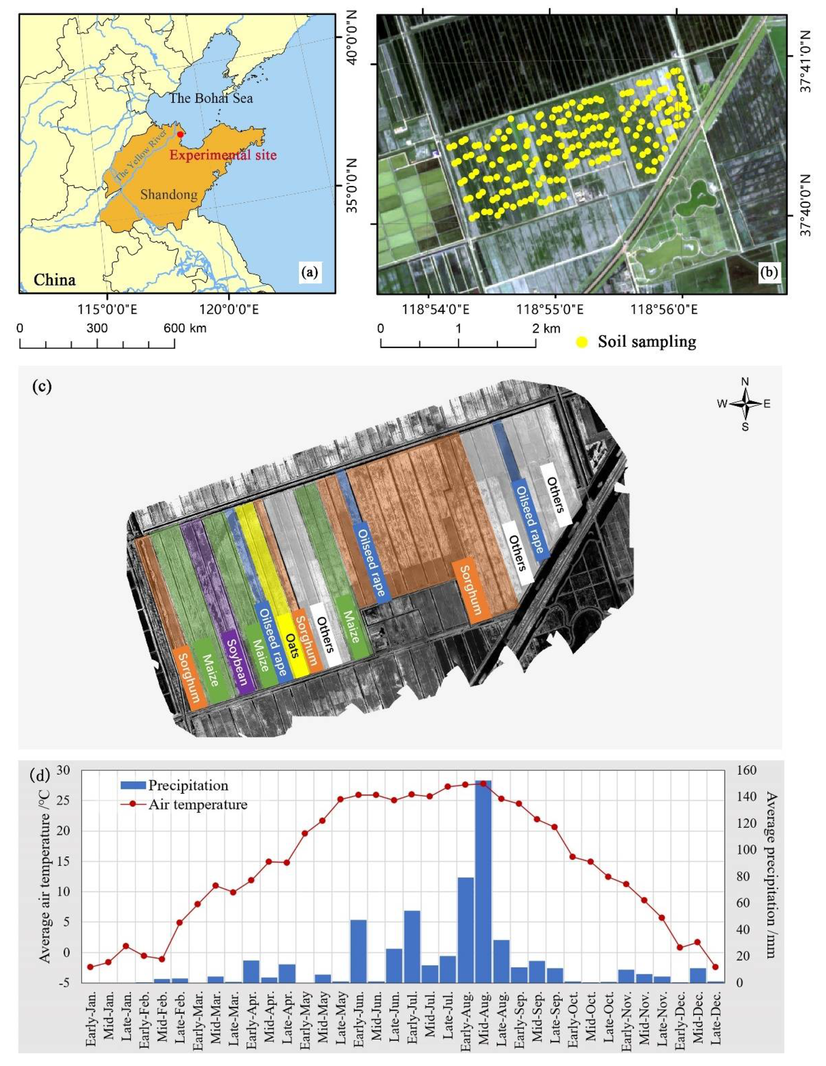
2.1. Description of the Study Area and Experimental Sites
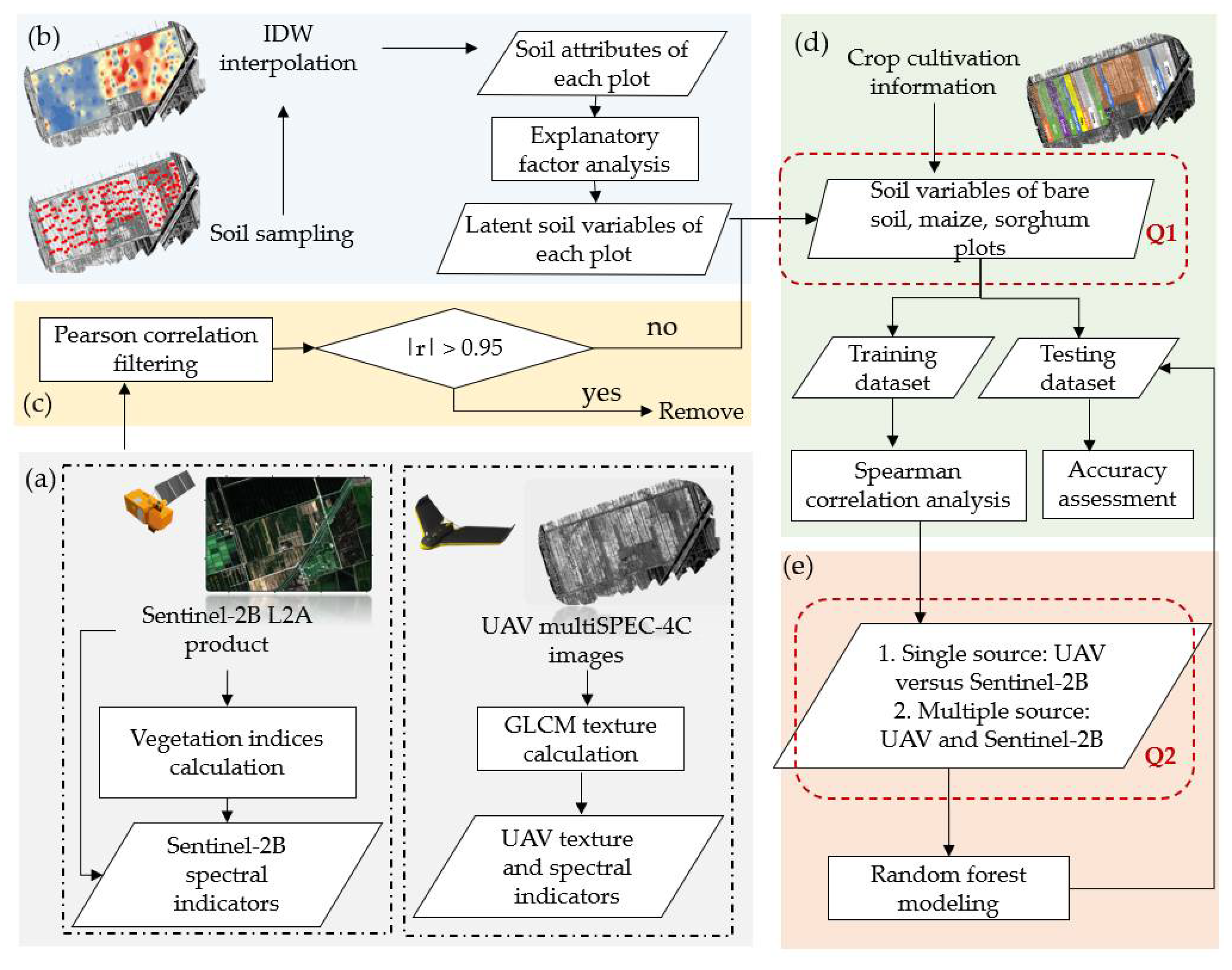
2.2. Overview of the Workflow in This Study
- (a)
- Generating remote sensing indicators, including UAV texture/spectral and Sentinel-2B spectral indicators, and investigating the difference between UAV and Sentinel-2B similar bands (Section 2.3.1, Section 2.3.2, Section 2.3.3);
- (b)
- Conducting the exploratory factor analysis to generate soil latent variables that could effectively reflect the variance of soil fertility and salinity (Section 2.4);
- (c)
- Conducting the Pearson correlation filtering to remove highly correlated remote sensing indicators when the |r| values are over 0.95 (Section 2.5.1);
- (d)
- Dividing the study area into three regions covered by the bare soil, maize, and sorghum, then conducting the Spearman correlation analysis to identify informative remote sensing indicators for the soil variable estimation (Section 2.5.2);
- (e)
- Running the random forest model to estimate soil variables using remote sensing indicators, comparing the performance of single- (UAV versus Sentinel-2B) and multi-source remote sensing data, investigating whether the integration of spectral and texture data could lead to a better estimation (research question 2), and comparing the soil variable estimation accuracy of places with different coverage—bare soil, maize, and sorghum (research question 1) (Section 2.5.3).
2.3. Acquisition and Processing of Remote Sensing Data
2.3.1. Acquisition and Pre-Processing of UAV Remote Sensing Data
2.3.2. Acquisition and Preprocessing of Sentinel-2 Data
2.3.3. Generation and Extraction of Remote Sensing Indicators
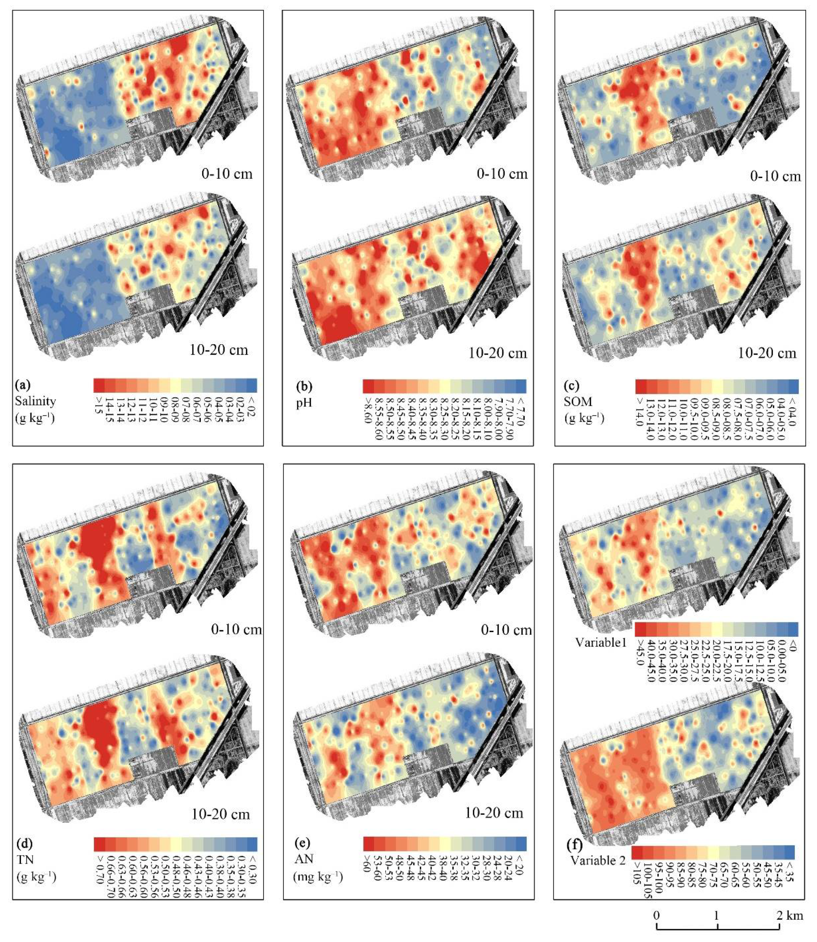
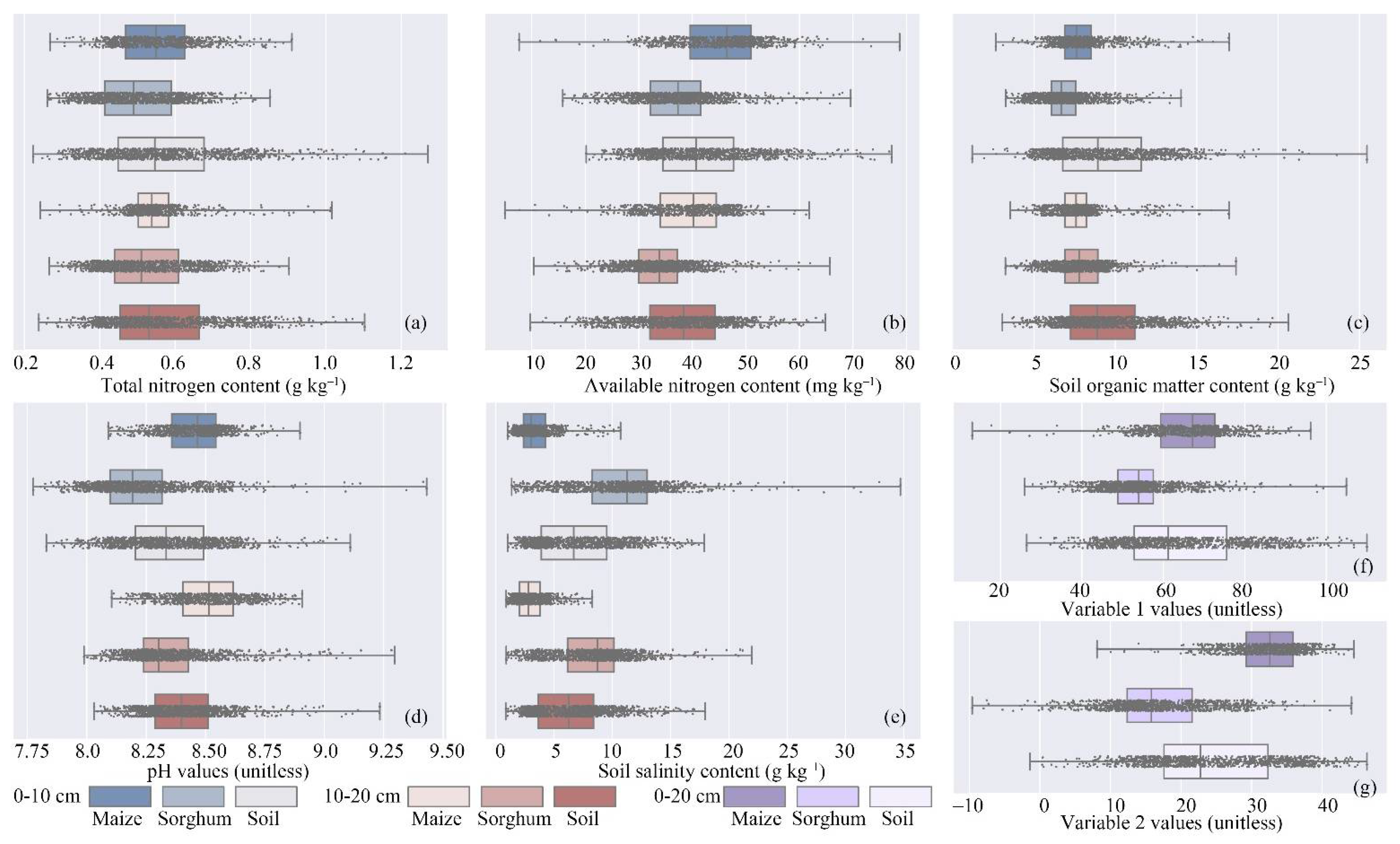
2.4. Collection and Processing of Soil Data
2.4.1. Ground Measurements
2.4.2. Explanatory Factor Analysis of Soil Attributes
2.5. Screening of UAV Variables and Modeling for Soil Latent Variable Estimation
2.5.1. Filtering Highly Correlated Remote Sensing Indicators
2.5.2. Spearman Correlation Analysis
2.5.3. Modeling and Accuracy Assessment
3. Results
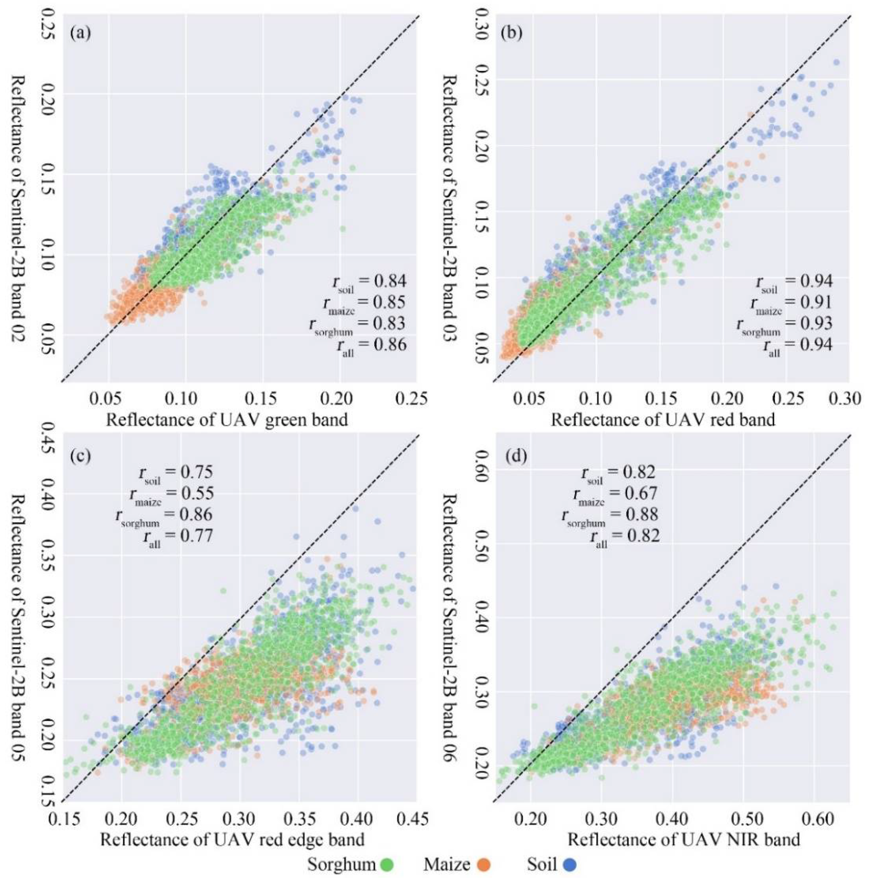
3.1. Relationships between UAV and Sentinel-2B Reflectance
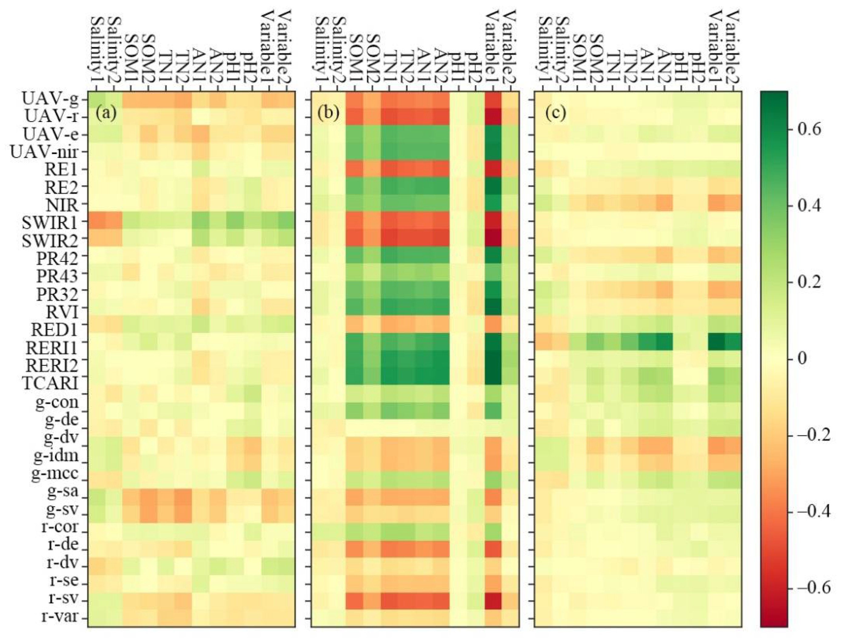
3.2. Relationships between Remote Sensing Indicators and Soil Indicators
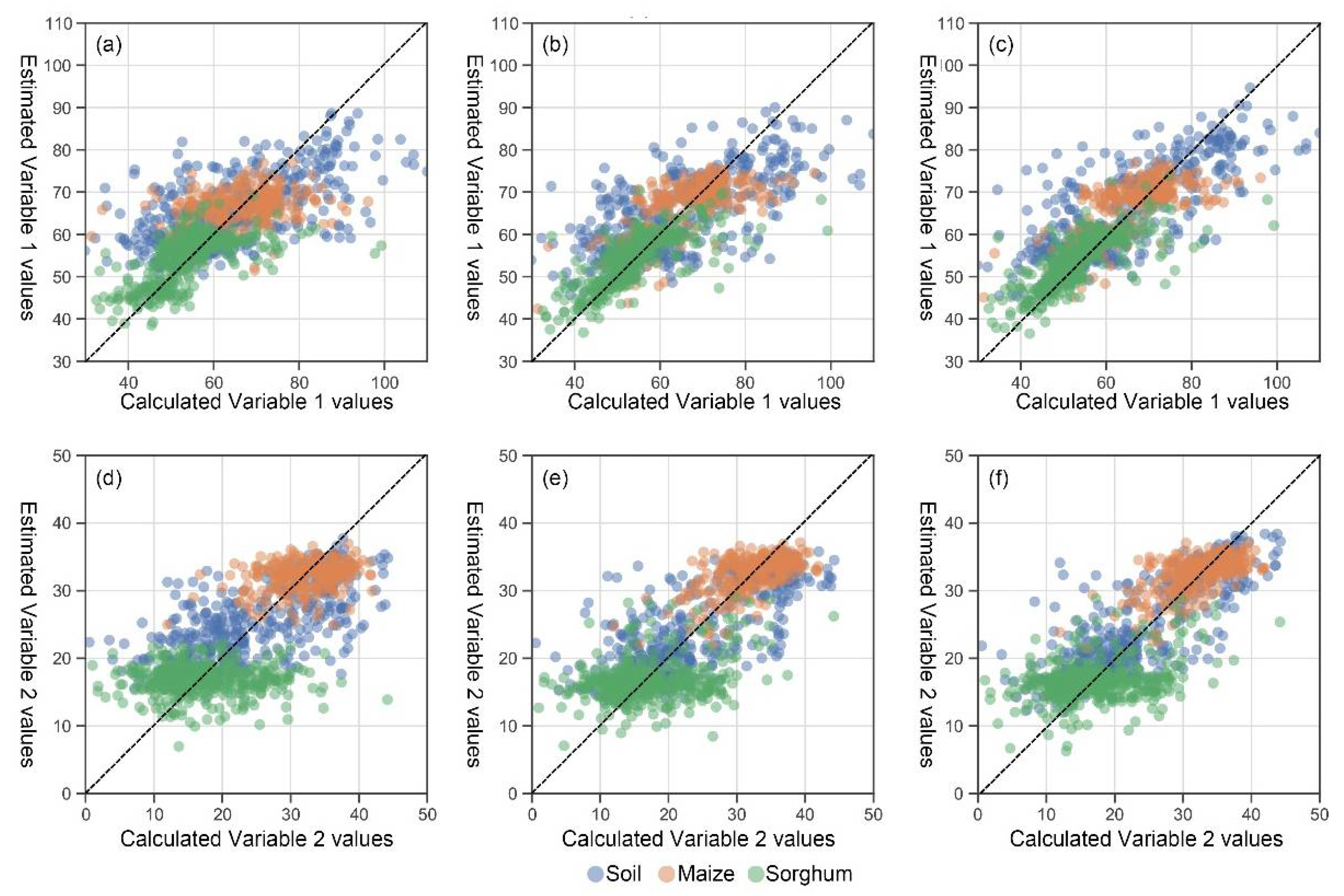
3.3. Estimation of Soil Variables Using Remote Sensing Indicators
4. Discussion
4.1. Factors Affecting the Relationships between UAV and Sentinel-2B Reflectance
4.2. Factors Affecting the Performance of Soil- and Crop-Based Remote Sensing Approaches
4.3. Factors Affecting the Performance of Distinct Remote Sensing Data Source
5. Conclusions
Supplementary Materials
Author Contributions
Funding
Acknowledgments
Conflicts of Interest
References
- Che, Z.; Wang, J.; Li, J. Effects of water quality, irrigation amount and nitrogen applied on soil salinity and cotton production under mulched drip irrigation in arid Northwest China. Agric. Water Manag. 2021, 247, 106738. [Google Scholar] [CrossRef]
- Sultana, S.; Alam, S.; Karim, M.M. Screening of siderophore-producing salt-tolerant rhizobacteria suitable for supporting plant growth in saline soils with iron limitation. J. Agric. Food Res. 2021, 4, 100150. [Google Scholar] [CrossRef]
- Zhu, L.; Jia, X.; Li, M.; Wang, Y.; Zhang, J.; Hou, J.; Wang, X. Associative effectiveness of bio-organic fertilizer and soil conditioners derived from the fermentation of food waste applied to greenhouse saline soil in Shan Dong Province, China. Appl. Soil Ecol. 2021, 167, 104006. [Google Scholar] [CrossRef]
- Chen, M.; Zhang, S.; Liu, L.; Wu, L.; Ding, X. Combined organic amendments and mineral fertilizer application increase rice yield by improving soil structure, P availability and root growth in saline-alkaline soil. Soil Tillage Res. 2021, 212, 105060. [Google Scholar] [CrossRef]
- Zhang, H.; Hobbie, E.A.; Feng, P.; Zhou, Z.; Niu, L.; Duan, W.; Hao, J.; Hu, K. Responses of soil organic carbon and crop yields to 33-year mineral fertilizer and straw additions under different tillage systems. Soil Tillage Res. 2021, 209, 104943. [Google Scholar] [CrossRef]
- Gong, H.; Li, Y.; Li, S. Effects of the interaction between biochar and nutrients on soil organic carbon sequestration in soda saline-alkali grassland: A review. Glob. Ecol. Conserv. 2021, 26, e01449. [Google Scholar] [CrossRef]
- Wong, V.N.L.; Greene, R.S.B.; Dalal, R.C.; Murphy, B.W. Soil carbon dynamics in saline and sodic soils: A review. Soil Use Manag. 2009, 26, 2–11. [Google Scholar] [CrossRef]
- Hurtado, A.C.; Chiconato, D.A.; Prado, R.D.M.; Junior, G.D.S.S.; Felisberto, G. Silicon attenuates sodium toxicity by improving nutritional efficiency in sorghum and sunflower plants. Plant Physiol. Biochem. 2019, 142, 224–233. [Google Scholar] [CrossRef]
- Fu, Y.; Yang, G.; Pu, R.; Li, Z.; Li, H.; Xu, X.; Song, X.; Yang, X.; Zhao, C. An overview of crop nitrogen status assessment using hyperspectral remote sensing: Current status and perspectives. Eur. J. Agron. 2021, 124, 126241. [Google Scholar] [CrossRef]
- Guan, Y.; Bai, J.; Wang, J.; Wang, W.; Wang, X.; Zhang, L.; Li, X.; Liu, X. Effects of groundwater tables and salinity levels on soil organic carbon and total nitrogen accumulation in coastal wetlands with different plant cover types in a Chinese estuary. Ecol. Indic. 2021, 121, 106969. [Google Scholar] [CrossRef]
- Garcia-Caparros, P.; Llanderal, A.; Lao, M.T. Effects of salinity on growth, water-use efficiency, and nutrient leaching of three containerized ornamental plants. Commun. Soil Sci. Plant Anal. 2017, 48, 1221–1230. [Google Scholar] [CrossRef]
- Zhu, H.; Yang, J.; Yao, R.; Wang, X.; Xie, W.; Zhu, W.; Liu, X.; Cao, Y.; Tao, J. Interactive effects of soil amendments (biochar and gypsum) and salinity on ammonia volatilization in coastal saline soil. Catena 2020, 190, 104527. [Google Scholar] [CrossRef]
- Ayoubi, S.; Khormali, F.; Sahrawat, K.L. Relationships of barley biomass and grain yields to soil properties within a field in the arid region: Use of factor analysis. Acta Agric. Scand. Sect. B Plant Soil Sci. 2009, 59, 107–117. [Google Scholar] [CrossRef] [Green Version]
- Nouri, H.; Borujeni, S.C.; Alaghmand, S.; Anderson, S.J.; Sutton, P.C.; Parvazian, S.; Beecham, S. Soil salinity mapping of urban greenery using remote sensing and proximal sensing techniques; The case of veale gardens within the adelaide parklands. Sustainability 2018, 10, 2826. [Google Scholar] [CrossRef] [Green Version]
- Sishodia, R.P.; Ray, R.L.; Singh, S.K. Applications of remote sensing in precision agriculture: A review. Remote Sens. 2020, 12, 3136. [Google Scholar] [CrossRef]
- Wang, D.; Chen, H.; Wang, Z.; Ma, Y. Inversion of soil salinity according to different salinization grades using multi-source remote sensing. Geocarto Int. 2020, 1–20. [Google Scholar] [CrossRef]
- Ma, Y.; Chen, H.; Zhao, G.; Wang, Z.; Wang, D. Spectral index fusion for salinized soil salinity inversion using sentinel-2A and UAV images in a coastal area. IEEE Access 2020, 8, 159595–159608. [Google Scholar] [CrossRef]
- Zhang, S.; Zhao, G. A Harmonious satellite-unmanned aerial vehicle-ground measurement inversion method for monitoring salinity in coastal saline soil. Remote Sens. 2019, 11, 1700. [Google Scholar] [CrossRef] [Green Version]
- Soudani, K.; François, C.; le Maire, G.; Le Dantec, V.; Dufrêne, E. Comparative analysis of IKONOS, SPOT, and ETM+ data for leaf area index estimation in temperate coniferous and deciduous forest stands. Remote Sens. Environ. 2006, 102, 161–175. [Google Scholar] [CrossRef] [Green Version]
- Zhu, W.; Sun, Z.; Huang, Y.; Yang, T.; Li, J.; Zhu, K.; Zhang, J.; Yang, B.; Shao, C.; Peng, J.; et al. Optimization of multi-source UAV RS agro-monitoring schemes designed for field-scale crop phenotyping. Precis. Agric. 2021, 22, 1768–1802. [Google Scholar] [CrossRef]
- Dong, J.; Crow, W.T.; Tobin, K.J.; Cosh, M.H.; Bosch, D.D.; Starks, P.J.; Seyfried, M.; Collins, C.H. Comparison of microwave remote sensing and land surface modeling for surface soil moisture climatology estimation. Remote Sens. Environ. 2020, 242, 111756. [Google Scholar] [CrossRef]
- Ramos, A.P.M.; Osco, L.P.; Furuya, D.E.G.; Gonçalves, W.N.; Santana, D.C.; Teodoro, L.P.R.; da Junior, C.A.S.; Capristo-Silva, G.F.; Li, J.; Baio, F.H.R.; et al. A random forest ranking approach to predict yield in maize with UAV-based vegetation spectral indices. Comput. Electron. Agric. 2020, 178, 105791. [Google Scholar] [CrossRef]
- Weng, Y.-L.; Gong, P.; Zhu, Z.-L. A spectral index for estimating soil salinity in the yellow river delta region of China using EO-1 hyperion data. Pedosphere 2010, 20, 378–388. [Google Scholar] [CrossRef]
- Chi, Y.; Shi, H.; Zheng, W.; Sun, J. Simulating spatial distribution of coastal soil carbon content using a comprehensive land surface factor system based on remote sensing. Sci. Total Environ. 2018, 628–629, 384–399. [Google Scholar] [CrossRef]
- Xu, Y.; Wang, X.; Bai, J.; Wang, D.; Wang, W.; Guan, Y. Estimating the spatial distribution of soil total nitrogen and available potassium in coastal wetland soils in the Yellow River Delta by incorporating multi-source data. Ecol. Indic. 2020, 111, 106002. [Google Scholar] [CrossRef]
- Ayub, M.; Ashraf, M.Y.; Kausar, A.; Saleem, S.; Anwar, S.; Altay, V.; Ozturk, M. Growth and physio-biochemical responses of maize (Zea Mays L.) to drought and heat stresses. Plant Biosyst. Int. J. Deal. All Asp. Plant Biol. 2021, 155, 535–542. [Google Scholar] [CrossRef]
- Zhu, K.; Sun, Z.; Zhao, F.; Yang, T.; Tian, Z.; Lai, J.; Zhu, W.; Long, B. Relating hyperspectral vegetation indices with soil salinity at different depths for the diagnosis of winter wheat salt stress. Remote Sens. 2021, 13, 250. [Google Scholar] [CrossRef]
- Song, C.; Ren, H.; Huang, C. Estimating soil salinity in the yellow river delta, eastern China—An integrated approach using spectral and terrain indices with the generalized additive model. Pedosphere 2016, 26, 626–635. [Google Scholar] [CrossRef]
- De Almeida, C.T.; Galvão, L.S.; Aragão, L.E.D.O.C.E.; Ometto, J.P.H.B.; Jacon, A.D.; Pereira, F.R.D.S.; Sato, L.Y.; Pontes-Lopes, A.; Graça, P.; Silva, C.V.D.J.; et al. Combining LiDAR and hyperspectral data for aboveground biomass modeling in the Brazilian Amazon using different regression algorithms. Remote Sens. Environ. 2019, 232, 111323. [Google Scholar] [CrossRef]
- Zhu, W.; Sun, Z.; Yang, T.; Li, J.; Peng, J.; Zhu, K.; Li, S.; Gong, H.; Lyu, Y.; Li, B.; et al. Estimating leaf chlorophyll content of crops via optimal unmanned aerial vehicle hyperspectral data at multi-scales. Comput. Electron. Agric. 2020, 178, 105786. [Google Scholar] [CrossRef]
- Yue, J.; Yang, G.; Tian, Q.; Feng, H.; Xu, K.; Zhou, C. Estimate of winter-wheat above-ground biomass based on UAV ultrahigh-ground-resolution image textures and vegetation indices. ISPRS J. Photogramm. Remote Sens. 2019, 150, 226–244. [Google Scholar] [CrossRef]
- Liu, G.; Li, J.; Zhang, X.; Wang, X.; Lv, Z.; Yang, J.; Shao, H.; Yu, S. GIS-mapping spatial distribution of soil salinity for Eco-restoring the Yellow River Delta in combination with Electromagnetic Induction. Ecol. Eng. 2016, 94, 306–314. [Google Scholar] [CrossRef]
- Wu, C.; Liu, G.; Huang, C.; Liu, Q. Soil quality assessment in Yellow River Delta: Establishing a minimum data set and fuzzy logic model. Geoderma 2019, 334, 82–89. [Google Scholar] [CrossRef]
- Zhu, W.; Yang, J.; Yao, R.; Wang, X.; Xie, W.; Li, P. Nitrate leaching and NH3 volatilization during soil reclamation in the yellow river delta, China. Environ. Pollut. 2021, 286, 117330. [Google Scholar] [CrossRef] [PubMed]
- Chi, Y.; Sun, J.; Liu, W.; Wang, J.; Zhao, M. Mapping coastal wetland soil salinity in different seasons using an improved comprehensive land surface factor system. Ecol. Indic. 2019, 107, 105517. [Google Scholar] [CrossRef]
- Xia, J.; Ren, J.; Zhang, S.; Wang, Y.; Fang, Y. Forest and grass composite patterns improve the soil quality in the coastal saline-alkali land of the Yellow River Delta, China. Geoderma 2019, 349, 25–35. [Google Scholar] [CrossRef]
- Yu, K.; Lenz-Wiedemann, V.; Chen, X.; Bareth, G. Estimating leaf chlorophyll of barley at different growth stages using spectral indices to reduce soil background and canopy structure effects. ISPRS J. Photogramm. Remote Sens. 2014, 97, 58–77. [Google Scholar] [CrossRef]
- Xie, Q.; Dash, J.; Huete, A.; Jiang, A.; Yin, G.; Ding, Y.; Peng, D.; Hall, C.C.; Brown, L.; Shi, Y.; et al. Retrieval of crop biophysical parameters from Sentinel-2 remote sensing imagery. Int. J. Appl. Earth Obs. Geoinf. 2019, 80, 187–195. [Google Scholar] [CrossRef]
- Daughtry, C.S.T.; Walthall, C.L.; Kim, M.S.; De Colstoun, E.B.; McMurtrey, J.E. Estimating Corn Leaf Chlorophyll Concentration from Leaf and Canopy Reflectance. Remote Sens. Environ. 2000, 74, 229–239. [Google Scholar] [CrossRef]
- Xu, M.; Liu, R.; Chen, J.M.; Liu, Y.; Shang, R.; Ju, W.; Wu, C.; Huang, W. Retrieving leaf chlorophyll content using a matrix-based vegetation index combination approach. Remote Sens. Environ. 2019, 224, 60–73. [Google Scholar] [CrossRef]
- Haboudane, D.; Miller, J.R.; Pattey, E.; Zarco-Tejada, P.J.; Strachan, I.B. Hyperspectral vegetation indices and novel algorithms for predicting green LAI of crop canopies: Modeling and validation in the context of precision agriculture. Remote Sens. Environ. 2004, 90, 337–352. [Google Scholar] [CrossRef]
- Peng, Y.; Nguy-Robertson, A.; Arkebauer, T.; Gitelson, A.A. Assessment of canopy chlorophyll content retrieval in maize and soybean: Implications of hysteresis on the development of generic algorithms. Remote Sens. 2017, 9, 226. [Google Scholar] [CrossRef] [Green Version]
- De Almeida, C.T.; Delgado, R.C.; Galvão, L.S.; Aragão, L.E.D.O.C.E.; Ramos, M.C. Improvements of the MODIS Gross Primary Productivity model based on a comprehensive uncertainty assessment over the Brazilian Amazonia. ISPRS J. Photogramm. Remote Sens. 2018, 145, 268–283. [Google Scholar] [CrossRef]
- Dong, T.; Liu, J.; Shang, J.; Qian, B.; Ma, B.; Kovacs, J.M.; Walters, D.; Jiao, X.; Geng, X.; Shi, Y. Assessment of red-edge vegetation indices for crop leaf area index estimation. Remote Sens. Environ. 2019, 222, 133–143. [Google Scholar] [CrossRef]
- Hillnhütter, C.; Mahlein, A.-K.; Sikora, R.; Oerke, E.-C. Remote sensing to detect plant stress induced by Heterodera schachtii and Rhizoctonia solani in sugar beet fields. Field Crop. Res. 2011, 122, 70–77. [Google Scholar] [CrossRef]
- Verger, A.; Vigneau, N.; Chéron, C.; Gilliot, J.-M.; Comar, A.; Baret, F. Green area index from an unmanned aerial system over wheat and rapeseed crops. Remote Sens. Environ. 2014, 152, 654–664. [Google Scholar] [CrossRef]
- Yu, H.; Kong, B.; Wang, G.; Du, R.; Qie, G. Prediction of soil properties using a hyperspectral remote sensing method. Arch. Agron. Soil Sci. 2017, 64, 546–559. [Google Scholar] [CrossRef]
- Xu, C.; Zeng, W.; Huang, J.; Wu, J.; Van Leeuwen, W.J. Prediction of soil moisture content and soil salt concentration from hyperspectral laboratory and field data. Remote Sens. 2016, 8, 42. [Google Scholar] [CrossRef] [Green Version]
- Ge, Y.; Thomasson, J.A.; Sui, R. Remote sensing of soil properties in precision agriculture: A review. Front. Earth Sci. 2011, 5, 229–238. [Google Scholar] [CrossRef]
- Vos, J.; van der Putten, P.; Birch, C. Effect of nitrogen supply on leaf appearance, leaf growth, leaf nitrogen economy and photosynthetic capacity in maize (Zea Mays L.). Field Crop. Res. 2005, 93, 64–73. [Google Scholar] [CrossRef]
- Chen, X.; Zhang, J.; Chen, Y.; Li, Q.; Chen, F.; Yuan, L.; Mi, G. Changes in root size and distribution in relation to nitrogen accumulation during maize breeding in China. Plant Soil 2014, 374, 121–130. [Google Scholar] [CrossRef]
- Schenk, H.J.; Jackson, R.B. The global biogeography of roots. Ecol. Monogr. 2002, 72, 311–328. [Google Scholar] [CrossRef]
- Ordóñez, R.A.; Castellano, M.J.; Danalatos, G.N.; Wright, E.E.; Hatfield, J.L.; Burras, L.; Archontoulis, S.V. Insufficient and excessive N fertilizer input reduces maize root mass across soil types. Field Crop. Res. 2021, 267, 108142. [Google Scholar] [CrossRef]
- Liu, M.; Wang, C.; Wang, F.; Xie, Y. Maize (Zea Mays) growth and nutrient uptake following integrated improvement of vermicompost and humic acid fertilizer on coastal saline soil. Appl. Soil Ecol. 2019, 142, 147–154. [Google Scholar] [CrossRef]
- Zhu, W.; Sun, Z.; Huang, Y.; Lai, J.; Li, J.; Zhang, J.; Yang, B.; Li, B.; Li, S.; Zhu, K.; et al. Improving field-scale wheat LAI retrieval based on UAV remote-sensing observations and optimized VI-LUTs. Remote Sens. 2019, 11, 2456. [Google Scholar] [CrossRef] [Green Version]

| Forms 1 | Names of Vegetation Indices | Formulas 2 | References |
|---|---|---|---|
| (b1 − b2)/(b1 + b2) | Normalized Difference Vegetation index | NDVI = (NIR − R)/(NIR + R) | [37] |
| Red edge NDVI | NDREij 1 = (REi − REj)/(REi + REj) | [38] | |
| Green NDVI | GNDVI = (NIR − G)/(NIR + G) | [39] | |
| b1/b2 | Simple Ratio | SR = NIR/G | [39] |
| Red edge reflectance ratio | PRij = REi/REj | [37] | |
| Ratio vegetation index | RVI = NIR/R | [38] | |
| b1 − b2 | Reflectance difference | RD = NIR − R | [37] |
| Red edge reflectance difference | REDi = REi − B | ||
| (b1 − b2)/b3 | Plant senescence reflectance index | PSRIi = (R − B)/REi | [40] |
| Chlorophyll index green | CIG = (REi − G)/G | ||
| Red Edge Relative Indices | RERIi = (REi − R)/NIR | ||
| Hybrid | Transformed Chlorophyll Absorption in Reflectance Index | TCARI = 3[(RE1 − R) − 0.2(RE1 – G)(RE1/R)] | [41] |
| Optimized soil adjusted vegetation index | OSAVI = 1.16(NIR − R)/(NIR + R + 0.16) | ||
| Enhanced Vegetation Index | EVI = 2.5 ((NIR−R)/(NIR + 6R − 7.5B + 1)) | [42] | |
| Improved chlorophyll absorption ratio index | MCARI = (RE1 − R) − 0.2(RE1 − G)(RE1/R) | [39] | |
| Red-edge vegetation stress index | RVSI = [(RE1 + RE3)/2] − RE2 | [43] | |
| Modified simple ratio | MSR = | [38] | |
| Modified simple ratio Red-edge | MSRRE = | [44] |
| PA1 2 | PA2 | h2 3 | u2 4 | ||
|---|---|---|---|---|---|
| Soil attributes 1 | salinity 0–10 cm | −0.26 | −0.87 | 0.83 | 0.17 |
| salinity 10–20 cm | −0.18 | −0.89 | 0.82 | 0.18 | |
| SOM 0–10 cm | 0.81 | 0.08 | 0.67 | 0.33 | |
| SOM 10–20 cm | 0.82 | −0.07 | 0.67 | 0.33 | |
| TN 0–10 cm | 0.85 | 0.15 | 0.75 | 0.25 | |
| TN 10–20 cm | 0.84 | 0.13 | 0.72 | 0.28 | |
| AN 0–10 cm | 0.56 | 0.34 | 0.44 | 0.56 | |
| AN 10–20 cm | 0.71 | 0.21 | 0.54 | 0.46 | |
| pH 0–10 cm | 0.09 | 0.84 | 0.71 | 0.29 | |
| pH 10–20 cm | 0.00 | 0.80 | 0.64 | 0.36 | |
| Cumulative variation | 0.37 | 0.68 | |||
| Proportion explained | 0.54 | 0.46 |
| Regions | Soil Variables | UAV Indicators | Sentinel-2B Indicators |
|---|---|---|---|
| Bare soil | Variable 1 | UAV-g, g-sa, g-sv, UAV-e, r-var | RERI1, RE1, RED1, SWIR2, SWIR1 |
| Variable 2 | UAV-g, g-sa, UAV-e, g-sv, r-dv | RVI, PR43, RED1, SWIR2, SWIR1 | |
| Sorghum | Variable 1 | UAV-r, r-sv, UAV-e, UAV-nir, UAV-g | SWIR2, RE2, RVI, RERI2, TCARI |
| Variable 2 | UAV-r, r-sv, UAV-e, UAV-nir, g-mcc | RERI2, TCARI, RERI1, RE2, RVI | |
| Maize | Variable 1 | g-dv, g-idm, g-de, g-mcc, g-con | NIR, PR32, PR42, TCARI, RERI1 |
| Variable 2 | g-dv, g-idm, g-con, g-mcc, g-de | NIR, PR32, RERI1, TCARI, RED1 |
| Soil Latent Variables | Regions | R2 | RMSE | MAPE (%) | ||||||
|---|---|---|---|---|---|---|---|---|---|---|
| UAV | L2A 1 | Inte. 2 | UAV | L2A | Inte. | UAV | L2A | Inte. | ||
| Variable 1 | Bare soil | 0.38 | 0.45 | 0.57 | 12.21 | 11.48 | 10.13 | 15.91 | 15.12 | 12.93 |
| Sorghum | 0.37 | 0.54 | 0.54 | 6.97 | 5.95 | 5.99 | 9.09 | 7.03 | 7.12 | |
| Maize | 0.12 | 0.48 | 0.49 | 9.18 | 7.04 | 7.01 | 11.55 | 8.58 | 8.59 | |
| All | 0.44 | 0.56 | 0.63 | 9.72 | 8.62 | 7.98 | 12.22 | 10.39 | 9.62 | |
| Variable 2 | Bare soil | 0.40 | 0.51 | 0.64 | 7.15 | 6.45 | 5.57 | 41.81 | 37.85 | 33.86 |
| Sorghum | 0.01 | 0.11 | 0.13 | 7.27 | 6.61 | 6.55 | 39.39 | 34.75 | 33.76 | |
| Maize | 0.09 | 0.35 | 0.37 | 4.61 | 3.88 | 3.80 | 12.50 | 10.33 | 10.08 | |
| All | 0.51 | 0.60 | 0.65 | 6.65 | 5.97 | 5.60 | 33.46 | 29.69 | 27.79 | |
Publisher’s Note: MDPI stays neutral with regard to jurisdictional claims in published maps and institutional affiliations. |
© 2021 by the authors. Licensee MDPI, Basel, Switzerland. This article is an open access article distributed under the terms and conditions of the Creative Commons Attribution (CC BY) license (https://creativecommons.org/licenses/by/4.0/).
Share and Cite
Zhu, W.; Rezaei, E.E.; Nouri, H.; Yang, T.; Li, B.; Gong, H.; Lyu, Y.; Peng, J.; Sun, Z. Quick Detection of Field-Scale Soil Comprehensive Attributes via the Integration of UAV and Sentinel-2B Remote Sensing Data. Remote Sens. 2021, 13, 4716. https://doi.org/10.3390/rs13224716
Zhu W, Rezaei EE, Nouri H, Yang T, Li B, Gong H, Lyu Y, Peng J, Sun Z. Quick Detection of Field-Scale Soil Comprehensive Attributes via the Integration of UAV and Sentinel-2B Remote Sensing Data. Remote Sensing. 2021; 13(22):4716. https://doi.org/10.3390/rs13224716
Chicago/Turabian StyleZhu, Wanxue, Ehsan Eyshi Rezaei, Hamideh Nouri, Ting Yang, Binbin Li, Huarui Gong, Yun Lyu, Jinbang Peng, and Zhigang Sun. 2021. "Quick Detection of Field-Scale Soil Comprehensive Attributes via the Integration of UAV and Sentinel-2B Remote Sensing Data" Remote Sensing 13, no. 22: 4716. https://doi.org/10.3390/rs13224716
APA StyleZhu, W., Rezaei, E. E., Nouri, H., Yang, T., Li, B., Gong, H., Lyu, Y., Peng, J., & Sun, Z. (2021). Quick Detection of Field-Scale Soil Comprehensive Attributes via the Integration of UAV and Sentinel-2B Remote Sensing Data. Remote Sensing, 13(22), 4716. https://doi.org/10.3390/rs13224716


