Article

Terraced Landscapes as NBSs for Geo-Hydrological Hazard Mitigation: Towards a Methodology for Debris and Soil Volume Estimations through a LiDAR Survey

1
Istituto di Ricerca per la Protezione Idrogeologica, Consiglio Nazionale delle Ricerche, Strada della Cacce 73, 10135 Turin, Italy
2
Indipendent Researcher, Lomas de Zamora B1832 JKC, Argentina
3
IHE Delft Institute for Water Education, 2601 DA Delft, The Netherlands
4
Department of Agricultural, Food, Environmental and Animal Sciences, University of Udine, Via delle Scienze 206, 33100 Udine, Italy
5
Department of Land, Environment, Agriculture and Forestry, University of Padua, Agripolis, viale dell’Università 16, 35020 Legnaro, Italy
6
Dipartimento di Scienze della Terra dell’Ambiente e della Vita, Università di Genova, Corso Europa 26, 16132 Genoa, Italy
*
Author to whom correspondence should be addressed.
Remote Sens. 2022, 14(15), 3586; https://doi.org/10.3390/rs14153586
Submission received: 8 April 2022 / Revised: 22 July 2022 / Accepted: 24 July 2022 / Published: 26 July 2022

Abstract

:
Terraced landscapes are widely applied in many mountainous regions around the world as a result of the necessity to practice subsistence agriculture. Hence, they can be regarded as one of the most diffused anthropogenic modifications of the Earth’s surface. Different techniques have been used for their implementation leading to the artificial immobilization of debris and soil along the slopes whose surface is interrupted by a sequence of sub-horizontal and sub-vertical areas often using stone walls. In some areas of the world, such interventions are thousands of years old and their resistance to the degradation caused by the morphogenetic system can be attributed to the permeability of the stone walls as well as to their regular maintenance. In some other areas, the lack of maintenance has been the main cause for degradation processes ending with their collapse. The effects of climate change manifested through higher intensities and higher frequencies of rainfall are likely to accelerate the degradation process further by causing terraces to act as a source of debris or hyperconcentrated flow. This will in turn increase the severity of geo-hydrological hazards. The measures concerning reduction of geo-hydrological hazards are sought through identification of abandoned terraces and assessment of the potential for their sudden collapse. The present paper describes a framework for identification of abandoned terraces and estimation of the potential volume of shallow landslides that can be generated. The research conducted aims to advance the existing hazard assessment practices by combining numerical modeling with processing of high-resolution LiDAR data. A new algorithm is developed to support localization of terraces. The catchment scale approach applied to eight smaller catchments enables estimation of the total volume of soil and debris trapped along the slopes. It also generated some important quantitative data which will be used in the future risk assessment work. The work has been carried out within the EU-funded H2020 project RECONECT.

Graphical Abstract

1. Introduction

Rural terraces represent stone artefacts that are commonly found in hilly and mountainous areas [1,2,3]. They are effective in decreasing the steepness of slopes, reducing soil erosion, slowing down the flows of water during extreme weather events, regulating their regime and increasing their permeability and infiltration capacity. As such, they are often used in soil and water conservation practices [4,5]. They can be also regarded as nature-based solutions (NBSs).
Typically, a series of terraces along a slope are arranged in a succession of walls in which the nutrients for the crops can be retained to get fertile soil. To ensure the drainage of excess water, the stone material is usually laid without a binder [6]. The hard work to make the land cultivable has thus given rise to a real “stepped land” of exploitation for agriculture in areas where spaces are limited and the slopes would not allow subsistence production [7,8,9].
The existence and importance of rural terraces in Italy can be traced back to the Neolithic era. Following the early medieval centuries, characterized by a barbarization of agricultural practices, around the year 1000 a.d., the first signs of economy were noticed. Lands that had long been abandoned or devastated by the barbarian’s violence returned to cultivation, reserving ample space for vines and olives. In the eighteenth century, agronomists of Tuscany began to “learn the art” of the accommodation of slopes in the hills and mountains, which are known as “the Tuscan masters of hill reclamation” [10]. A series of agronomic treatises produced in the eighteenth and nineteenth centuries noted how the situation was then very critical due to the prevalence of “rittochino” crops [11], which is realized following the maximum slope gradient. The work of the Tuscan reclamation workers was against “rittochino” cultivation systems and in favor of “cross” processing, which is less subjected to problems of surface instability and soil erosion.
For centuries, terraces have been recognized as an essential tool for the agriculture of the Mediterranean landscape [10,12]. The national inventory of the historical rural landscape has signaled the presence of terraces with multiple qualities of crops, even if vines seemed to be the most frequent in some areas [13,14]. The highest percentage of terraced areas is found in Liguria; for over a millennium, the intensive cultivation of olive trees and vines has been practiced in a difficult territory characterized by steep slopes. It has been estimated that terraced areas in Liguria make up at least 6.8% (373 km2) of the entire surface of the region, while the actual situation probably exceeds this figure. We can certainly affirm that Liguria is a territory largely formed by artificial terraces that define the character of its landscape. Since the 1940s, due to the progressive abandonment of agricultural practices in mountainous and hilly regions, there has been a deterioration in the state of conservation of those typical elements of the agricultural landscape. This can be found not only in Italy, but also in many other places around the world [14,15,16,17,18,19,20].
In Liguria, since the 1950s, agricultural practices in mountainous landscapes have been significatively reduced causing terraces to become unstable and triggering landslides during flood events [9,21]. In 2011, a devastating flash flood hit the famous landscape of Cinque Terre after a violent storm, triggering hundreds of shallow landslides in small and steep catchments. On 25 October 2011, a violent storm in this area resulted in 542 mm of rainfall in six hours [22]. On one side, most of those terraces that are still planted with vines resisted the high quantity of runoff while, on the other side, many of the landslides that contributed to the destruction of Vernazza and Monterosso originated from the abandoned terraces.
The loss of the terraced sector as an area intended for agricultural production requires the careful analysis of soil loss as part of the overall morphological stability. The progressive decay of the dry-stone walls, and therefore of the terraced bands, represents a crucial issue, both for the spatial dimensions of the development of these artifacts and for their location upstream and downstream of road infrastructures [3,13]. The abandonment of terracing, with the spontaneous growth of trees and the consequent instability of dry-stone walls, appears to be the main cause of the current instability, causing collapses [23], superficial and deep landslides and debris flows [3,21].
Agnoletti, in 2019 [13], noted that, in the Cinque Terre, no landslide occurred in areas cultivated with traditional terracing, while this was not the case in areas where terraces were abandoned and covered by the woods. It is easy for abandonment to cause an exacerbation of problems associated with surface landslides and flows, due to an increase in unstable material (stones and earth) in the surface horizons. This aspect must be analyzed in the degradation dynamics even considering the increase in high-intensity rainfall. The progressive abandonment of terraces and the lack of proper maintenance are the main causes of instability; moreover, the colonization of shrub and tree species are likely to further increase the risk factors as roots make the walls unstable. In such cases, the unstable terraced areas can provide significant amounts of detritus for the processes of geo-hydrological instability. The process of estimating detrital volumes necessitates the use of adequate analytical elements [24].
Giordan, in 2017 [21], analyzed a series of rainfall events that occurred in Liguria in 2014, which triggered numerous shallow landslides and caused the loss of human lives and serious structural damage. In an area of 385 km2, more than 1600 landslides were identified. The authors highlighted the link with different human activities, as most of the detected landslides occurred in anthropized areas. Geospatial and statistical analyses made it possible to identify three main anthropogenic factors: terraces, their maintenance condition and the presence of road networks. The more common failure issue is related to poor or absent maintenance. Numerous landslides could have been avoided if the appropriate maintenance of terraces had been conducted regularly.
Remote sensing coupled with high-resolution topographic technologies (HRTs) plays a vital role in identifying and assessing terraces. High-precision monitoring, such as airborne laser scanning (ALS), which uses light detection and ranging technology (LiDAR) allows us to map large abandoned areas, even when re-vegetated [5,25,26,27]. These techniques may be accompanied by other techniques, such as terrestrial laser scanning (TLS), which are altogether represent invaluable means for identifying vertical surfaces as dry-stone walls supporting terraces [28]. Paired survey methods are often used to overcome each other’s limitations [29]. HRT techniques allow us to obtain high-resolution digital terrain models (DTMs) from which high-precision parameters can be extracted, enabling the geometric definition of terraces [30,31] in a GIS environment. The original geometry of the terraces is of primary importance for the definition of the movable volumes during an unstable landslide or debris flow to establish the potential extent of impacts. This analytical contribution could also provide elements of analysis of the potential risk at slope or basin scales for anthropogenic settlements for homogeneous areas.
The present paper describes the research conducted as part of the Horizon 2020 RECONECT project [32]. Through monitoring activities of the project, it was possible to ascertain the baseline data for pilot areas, which for the Italian partnership are in the Portofino Promontory. The present study aims to advance the hazard assessment of terraces by generating quantitative data, which in turn may be used as valuable inputs in numerical modeling. The research connects to the work of previous research and advances by using high-detail LiDAR data obtained by a dedicated ALS survey. The terraces have been identified at the catchment scale and their soil and debris volumes have been estimated and analyzed both in relation to the slope gradient and surface area. A new algorithm, of which the performance has been assessed using quantitative techniques, has been developed to enhance the localization of terraces. In addition, the catchment scale approach, applied to eight small catchments, allowed us to estimate the total volume of soil and debris trapped along the slopes and produced valuable quantitative spatial data, which may be related to exposed elements and used in future research. Therefore, the present work expands on the work of previous researchers involved in risk assessment at the catchment scale.

2. Materials and Methods
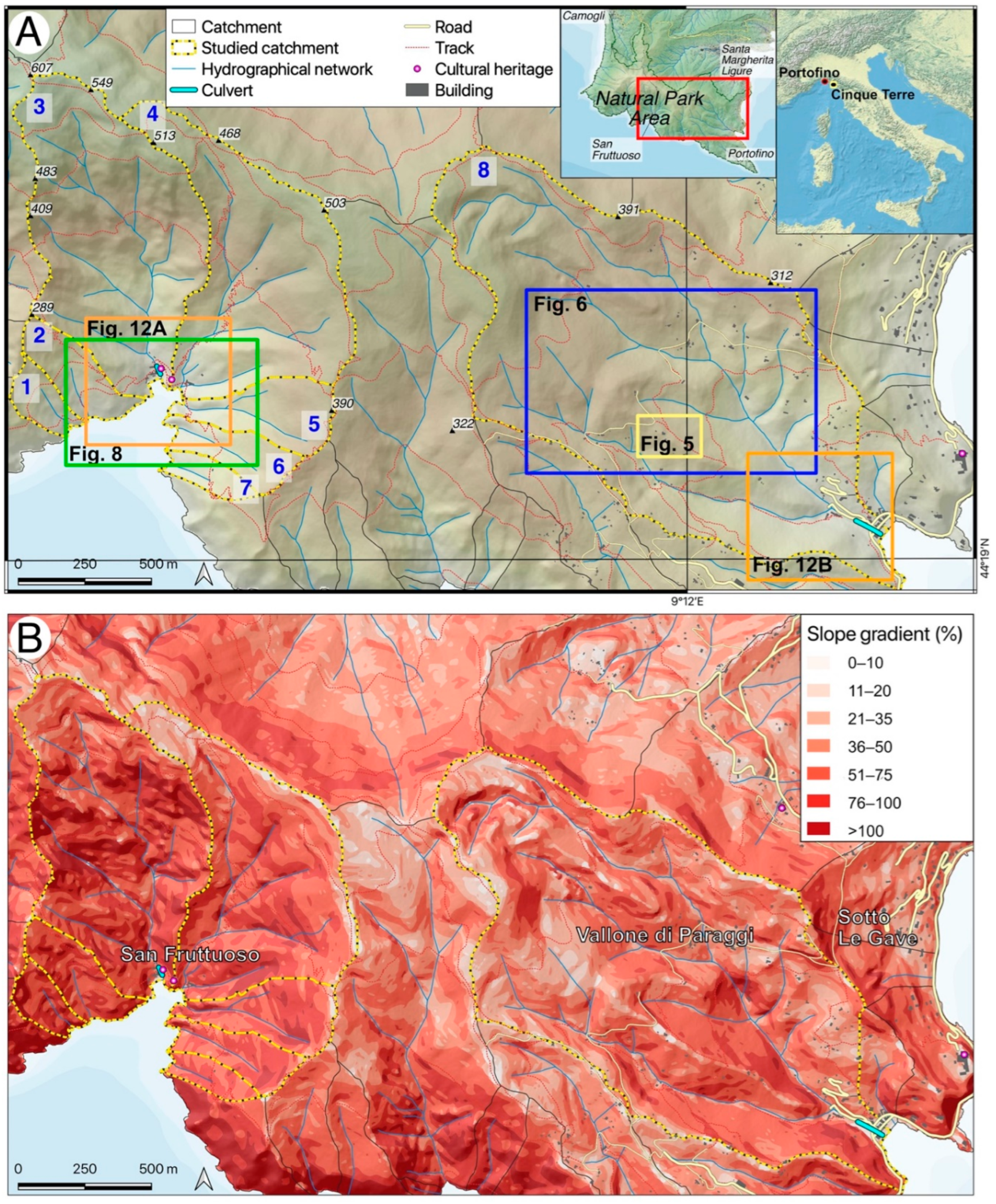
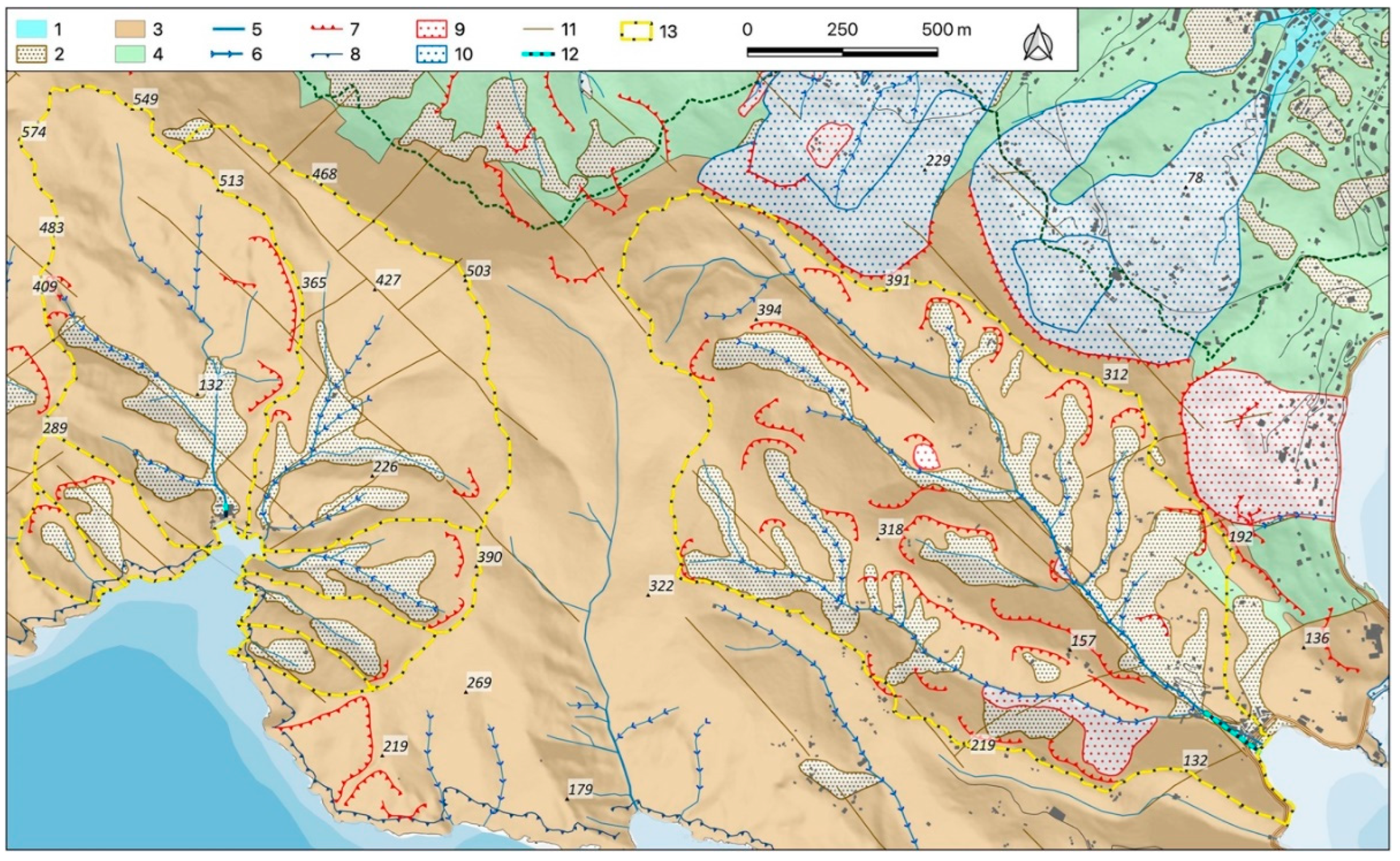
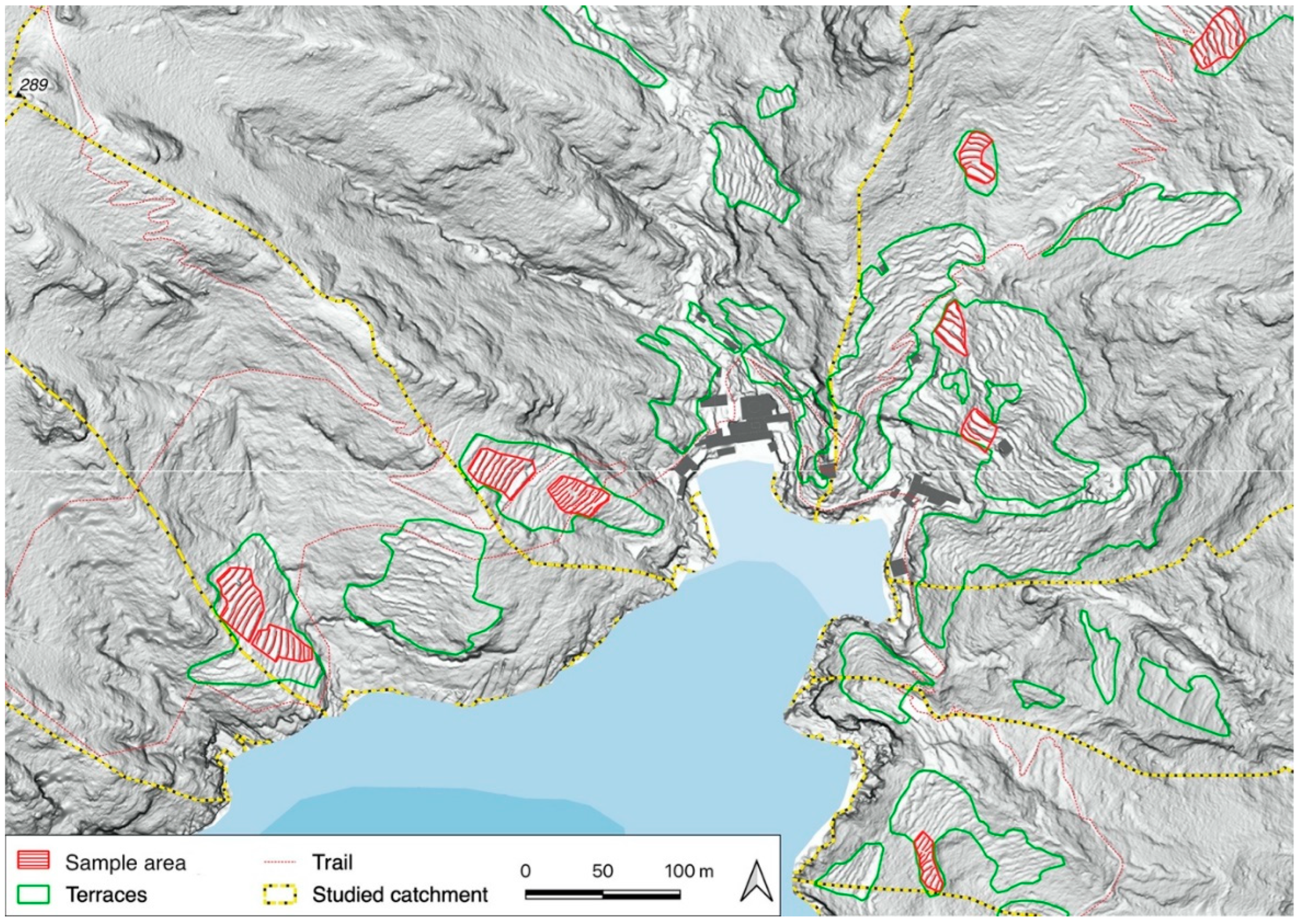
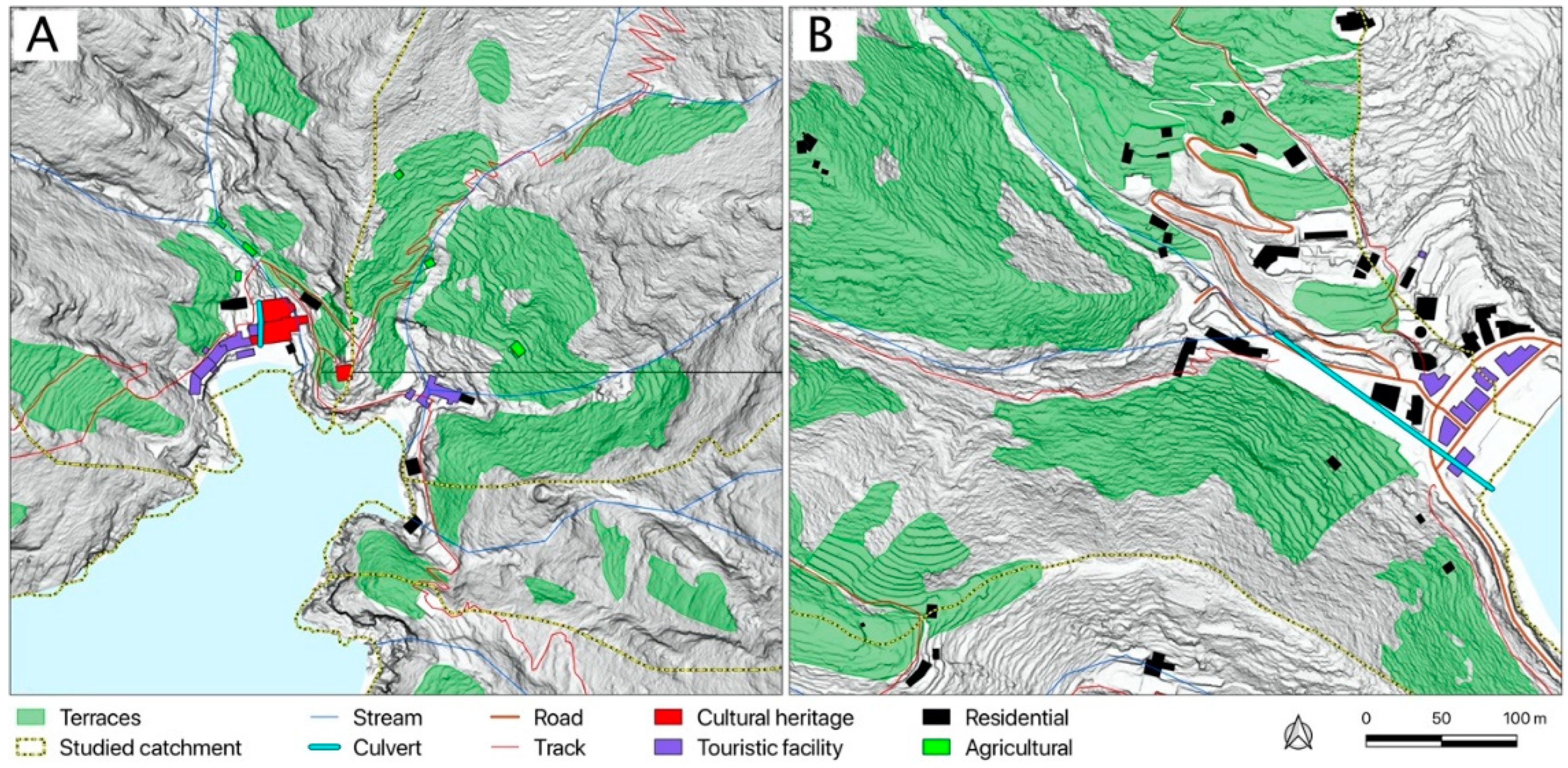
2.1. The Study Area

The Promontory of Portofino is located roughly at the center of the Ligurian coastline and breaks the continuity of the coastline between Genova and La Spezia (Figure 1A). The orography [31] shows rather high altitudes related to the distance of the coastline: an WNW-ESE-oriented relief with Mounts Tocco (543 m), Portofino (610 m), delle Bocche (506 m) and Pollone (472 m) is easily recognized. Most of the hydrographic catchments are less than 1 km2 wide, with channels of the 2nd order at the most. As a result of its landscape and cultural values, the Promontory of Portofino has been protected since 1935 by Law no. 1251 (Kingdom of Italy), and very recently, in 2021, the Portofino National Park was established.
The geology of Portofino Mount is made of two rock masses [33,34] (Figure 2): (1) Portofino Conglomerate, in the south-facing small catchments between the two eastern and western capes of the Promontory, and (2) a marly limestone lithotype (Mt. Antola Flysch) in the rest of the Promontory. The boundary between these two rocks is partially referable to tectonic causes and shows a WNW-ESE trend (Figure 2). The Promontory’s morphology is derived from a structure bounded by normal faults, typical of a continental margin subject to strong neotectonic activity [35].
The Portofino Conglomerate is made up of marly limestone clasts and, to a lesser degree, sandstone, ranging in size from centimeters to meters, arranged in several-meters-thick layers with rare sandstone intervals, often accompanied by thin coal layers. The structural setting of the Conglomerate shows an SE to SW dip, with a dip less than 20°. The rock mass features several joint systems, recognized at a meso and macro scale. The NW–SE- and NE–SW-oriented systems, which are tied to normal faults, are the most important. Mt. Antola Flysch is made up of marly limestone, marls with shale interlayers, siltites and calcarenites. The structural setting of the flysch is constrained by several deformation phases, both ductile and brittle, which affect this rock mass.
The geomorphological features of the study area are influenced by geological–tectonic settings and linked to meteo-climate conditions. Rocky cliffs up to 200 m high characterize the southern slope of the Promontory of Portofino. The average inclination of the slope is 45° to 65°, up to vertical cliffs, as in the southern slope [33] (Figure 1B). Sea storms are rather frequent, with wave heights exceeding 5 m; they can cause serious damage to buildings and infrastructures, as in the event of 27–29 October 2018, which affected the Promontory’s eastern coast.
In the high conglomerate rocky coast of the southern slope, there are often rock falls, even along very steep fluvial channels, mostly of the 1st order. On the western slope, the sea cliff has been prevalently shaped in Mt. Antola Flysch, attaining heights exceeding 100 m. This stretch of coast is subject to a SW sea storm, which is one of the main causes of the occurrence of rapid slope movements, such as debris/mud flows and rock avalanches, which often have a high destructive power. There are also slow slope movements with ruptured surfaces in the marly calcareous bedrock. Along the boundary between the conglomerate and flysch, there are landslides of diverse kynematics and states of activity owing to the contrast of strength and deformability between the rock masses. Among the landslides surveyed, worthy of note is the accumulation found at Sotto Le Gave, on the eastern slope, which is partially due to mountain slope deformation and has affected buildings and infrastructures even in the recent past.
The meteo-climatic features of this area are linked to the cyclogenesis of the Gulf of Genoa [36], which causes events of short but intense precipitation (less than 6 h, with rain peaks exceeding 50 mm/h) between mid-summer and mid-autumn. These frequent extreme weather conditions [37,38] cause flash floods and debris/mud flows [39]. Among the most significant and destructive events in living memory, those of 1915, 1961 and 1995/1996 should be mentioned [40]. Additionally, in the 2000–2018 period, many extreme hydro-meteorological events occurred on the Portofino Promontory [40], triggering severe processes causing considerable damage to buildings and infrastructures: the average, on a historical basis, is over one event per year.
Among the anthropic landforms, dry-wall slope terracing is a very common farming technique that dates back to ancient times [9]. Terracing has severely modified the geomorphological, vegetation and anthropic landscape at a slope scale. Well-preserved examples of slope terracing can be observed in the Paraggi, Portofino and San Fruttuoso catchments; they make up an important cultural and landscape asset.

2.2. Topographic Data

A dedicated ALS survey was conducted under the monitoring activities of the RECONECT project. The flight was performed in February 2020 and the topographic survey for the ground control points (GCPs) was completed a few months later in June 2020 due to the restrictions caused by the pandemic.
A LiDAR system Riegl VQ 1560-II with two 2 MHz sensors coupled to a Phase One IXM-RS150MF camera was used to obtain a point density of up to 20 m−2 from a flight altitude of 5000 ft. The subsequent point classification allowed us to obtain a 0.5 m DTM; an orthophotomosaic at a 5 cm resolution in both RGB (red, green and blue) and CIR (color infrared) were also obtained.
Other vector format data were used, collected from the Regione Liguria authority databases, as detailed in Table 1.

2.3. Research Workflow

The assessment of the anthropogenic remolded volume in terraces was conducted according to the scheme presented in Figure 3 and following the methodology developed by Cucchiaro et al. [31]. The terraces were detected using ALS data and the application of three algorithms. LiDAR data were extensively used from features on the ground-surface detection [41] and monitoring changes [42], to assess the presence of water vapor in the atmosphere [43]. Then, 32 terraced slopes were identified in the whole area considering the more regular ones, avoiding surfaces that were too complex with considerable changes in their curvature. Later, dry-stone-wall bases were located via the application of three algorithms. Subsequently, for every identified slope, the bases were vectorized and a natural neighbor interpolation technique was applied.
Finally, the volume trapped into terraces was estimated by computing the difference between the actual surface and the interpolated one. The computation of the DoD (DEM of differences) is widely used to characterize the Earth’s changing surface [44,45,46]. The calculation was repeated for every single identified slope. Analyses and elaborations were conducted on QGis 3.16 and using SAGA (System for Automated Geoscientific Analysis) GIS modules.

2.3.1. Terrace Detection

Terrace and dry-stone-wall basis locations were obtained through the application of three algorithms: local upslope curvature calculation (LUC), sky view factor (SKF) and LiDAR image highlighting algorithm (LIHA). The first two algorithms were previously tested and used on older and lower-resolution LiDAR data [24], while the last one was developed by Mario Profeta.
LUC is a routine developed in SAGA GIS: for every cell, it is defined as the mean of local curvatures of the directly neighboring upslope contributing cells, where local curvature is defined as the sum of gradients to the neighboring cells [47,48]. High negative values of LUC identify the dry-stone wall’s basis. The methodology was previously tested and validated on the ground [24]. The capability of SKF [49] in identifying terraces has already been successfully verified [50]. The sixteen sectors’ computation in SAGA GIS was used in this research.
The inspiration for the development of a new LIHA algorithm was sought from the seismic signals data analysis literature. Algorithms for processing seismic exploration data were used to create a ground ALS-derived grid with LIHA. To achieve this, the five-step procedure shown below was followed:
  • Based on the ALS terrain elevation data, a grid—called an input grid—was created. The input grid consisted of columns and rows, where a node containing terrain-elevation information for that position was placed at every node.
  • The input grid was considered to consist of a group of columns, that is, the concept of row was put aside; the group of columns contains the same information that is contained in the input grid.
  • Terrain elevation figures along every column were considered as being seismic wave amplitude data. Then, each column was considered as being a seismic trace (ST) composed of amplitude figures.
  • Thus, by considering one ST at a time and applying a set of seismic data processing algorithms to the ST, weak or subtle events occurring at each ST were enhanced; these subtle events correspond to the weak topographic features contained in the input grid. The same set of enhancement algorithms was applied to all STs.
  • After being processed, all STs were placed back in the same position as in the input grid obtaining a new grid where the weak topographic features contained in the original grid appeared enhanced. This new resulting grid is called a ground ALS-derived grid with LIHA applied.
The identification of terraces and relative dry-stone walls was obtained using the three methods that have been controlled on the ground in areas across the study area catchments (Figure 4). These were selected in accordance to the more critical ones in terms of: (i) difficulties in identifying terraces with semi-automatic methods due to the presence of high vegetation quantities, and (ii) abandonment and discontinuous structures caused by partial collapse or by the presence of outcrop morphological features, such as sedimentary rock masses or tectonic structures.
In order to assess the accuracy of terrace identification through the three methodologies, the following approach was followed. At first, a partially terraced area was identified, including vegetated portions: the real consistency of terraces was verified through orthophotography analyses as well as the ground survey. Then, the terraced areas detected through the three methodologies were compared to the orthophotography/direct survey data computing the quality index [51] and Cohen’s kappa standard accuracy [52].

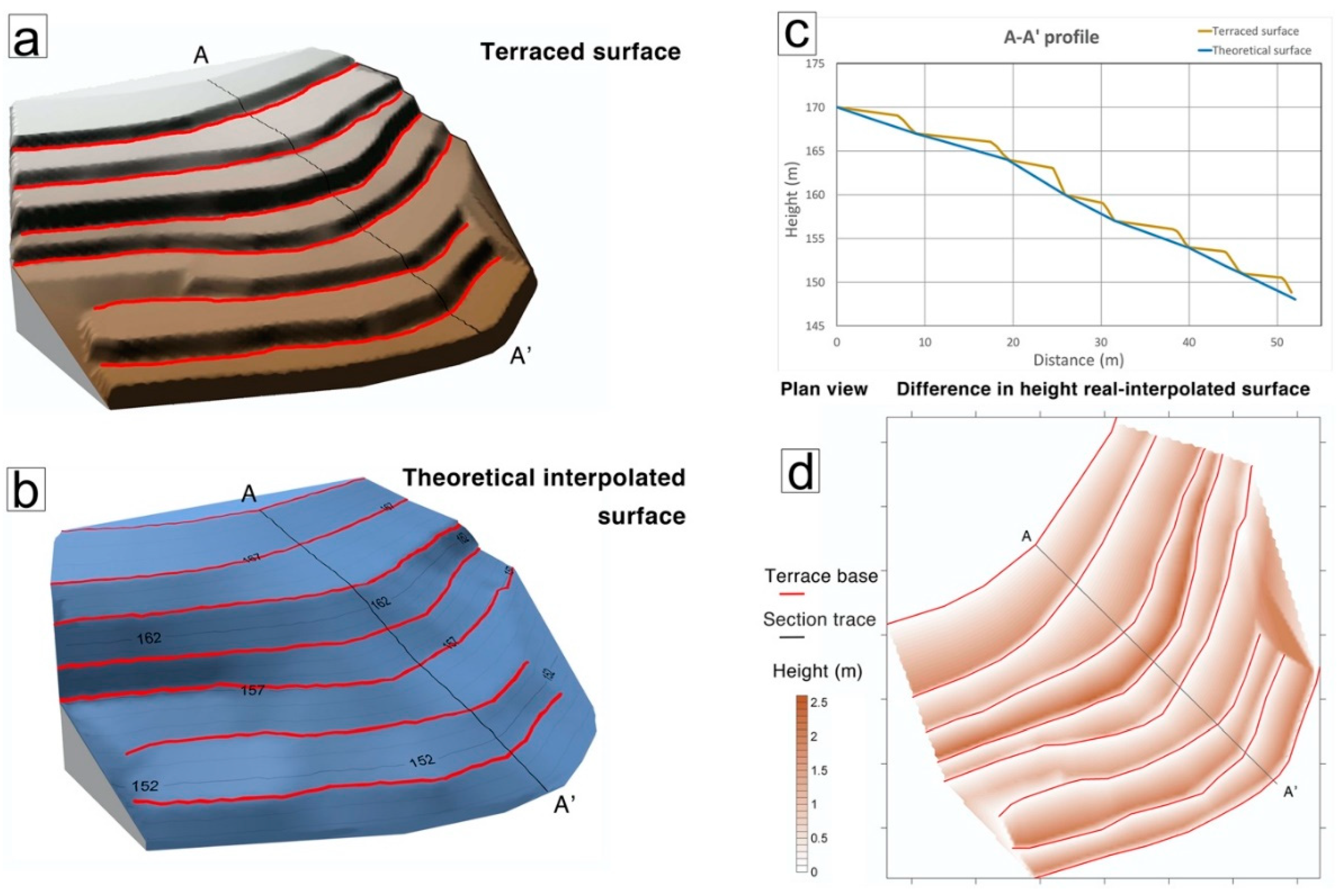
2.3.2. Volume Estimation

The identification of dry-stone walls allowed us to obtain a theoretical surface without terraces through a natural neighbor interpolation (Figure 5). Thus, by computing the difference between this smoothed surface and the real one, an estimation of the anthropogenic remolded volume was obtained according to the method developed by Cucchiaro et al. [31].
The procedure may underestimate or overestimate the real volume, considering that the real surface under terraces may follow a concave or convex shape. In order to reduce this uncertainty, regular slopes were chosen; furthermore, it may be assumed that the two opposite errors tend to compensate each other considering the performance of the computation on many different slopes.

3. Results

3.1. Terrace Identification Error Assessment

The high-resolution ALS data and methods used to assess the presence of terraces enabled us to update the results obtained in a preliminary state of the research when more rough and older data were used [24]. To assess the accuracy of identification with SKF, LUC and LIHA methods, the test area in Figure 6 was identified.
Following the previously described approach, both quality index and Cohn’s kappa were computed (please refer Table 2). The application of LIHA presents more reliable results: both the quality index and Kappa reached the highest values, whereas the SKF method shows a lower degree of accuracy.

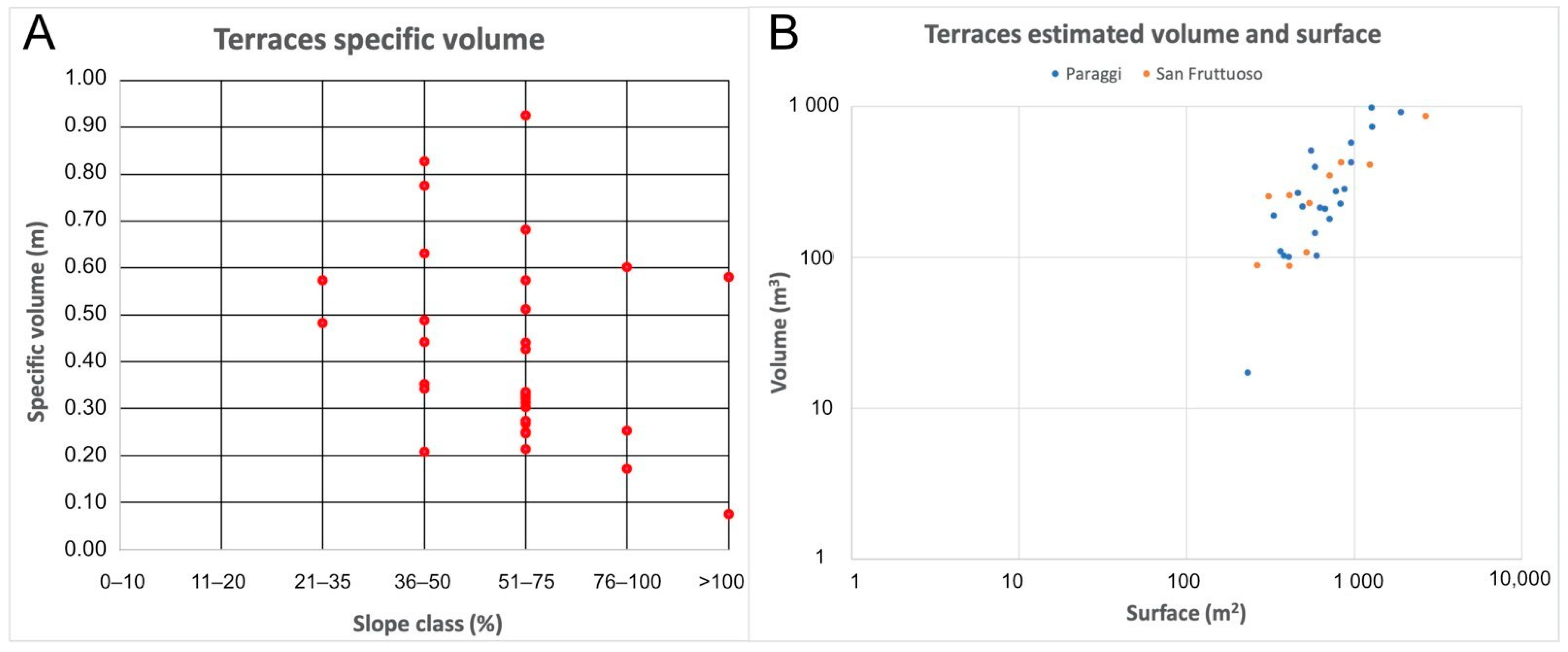
3.2. Terraces’ Identification and Volume Estimation

Table 3 shows the consistency of terraces in the eight small catchments together with their main features. The Paraggi catchment (8), which is the largest catchment in the case study area, presents the highest terraced surface in percentage, probably due to a lower mean gradient, which is more suitable for practicing subsistence agriculture. On the other hand, the other very small catchments show very high mean gradients and lower percentages of terraced areas. Despite these lower values, the terraces’ presence is significant and confirms the hard work needed for their realization. In addition, a historical olive orchard is present in catchment n. 2; its high cultural value is threatened by the lack of maintenance and the presence of several collapsed portions.
With respect to the previous results, the actual outline of terraces is more detailed, and even small or discontinuous partially collapsed terraces were localized. It is the case of terraces in the middle portion of catchment 3 that was found to be in an apparently unfavorable condition: a very steep slope facing North-West/West in a very embedded position close to the stream. Additionally, these terraces are interposed between emerging sedimentary layers and deeply hidden by the vegetation. The control performed on the ground allowed us to confirm the precise detection through the applied methodology.
Figure 7 depicts a 3D model of the middle portion of the Paraggi catchment (8) with the orthophotography, SKF and LUC algorithm applied to compare the enhancement of features that may be obtained through the high-detail data. The choice of performing the ALS survey obtaining a 0.5 m DTM represents a good accommodation between the detection of morphological features, costs of data acquisition and elaboration, and the ease of data manipulation. In fact, due to the high slope gradient of the studied areas, many terraces are characterized by a low depth, that is, the distance between the edge of the stone wall and the basis of the upper one. In the steeper zones, this depth is up to 2 m, then a 0.5 m DTM allows for their detection. It follows that in areas that are more difficult to access, terraces can be detected and a high precision of border identification can be obtained. Furthermore, Figure 6, parts C and D, show a proper filtering of the LUC and LIHA algorithms, which in turn allow evidencing the terraces’ bases, presenting the possibility to automatically obtain their altitude from the DTM.
In Figure 8, a further enhancement of features with a detailed localization of dry-stone walls was obtained using the LIHA algorithm. Even in critical zones where SKF and the LUC algorithm show a degree of unreliability, the LIHA allowed us to correctly discriminate between the presence or absence of terraces. The ground survey in areas with thick vegetation and complex morphometry confirmed the correct detection of terraces, as in point 1 in Figure 8, where the possible presence of terraces was correctly excluded by the LIHA algorithm.
Following the identification of terraces and dry-stone walls, 32 small and regular slopes were selected in order to perform the volume calculation (Figure 9): 10 were identified in San Fruttuoso area and 22 in the Paraggi area. In Figure 10, a detail of the San Fruttuoso area is shown with sampled terraced slopes and evidence of dry-stone walls. The volume calculation procedure was applied to every slope and the calculated specific volume, that is, the volume per surface unit, which was computed separately for the San Fruttuoso and Paraggi areas.
In Table 4, the mean specific volumes and mean weighted ones are presented; the latter was obtained with respect to the weighting of the surface area of the slopes. The mean specific volume values are similar, but a slight difference can be observed with relation to the weighted ones.
With relation to the specific volume data to the slope steepness and according to the classes defined in Figure 1B, evidence of eventual relationships between specific volume and the slope gradient can be observed. A steeper slope allows us to accommodate only small surface terraces with high walls, while a milder slope accepts larger terraces with shorter dry-stone walls containing them. In Figure 11A, the specific volumes are shown with respect to the slope classes. No evidence of a relationship between specific volume and slope gradient can be observed. In fact, specific volumes were accommodated in quite a wide range of values independently from the slope gradient, but this amplitude tended to reduce the higher slope gradient classes. Additionally, specific volumes were related to the terraced slope areas (Figure 11B) considered as distinct data obtained from the San Fruttuoso and Paraggi areas. The bi-logarithm diagram shows that figures that tend to be aligned suggest a possible scale invariance behavior between the specific volume and relative surface area. No differences can be observed between values belonging to the San Fruttuoso or Paraggi areas.

4. Discussion

The methodology applied to the case study area using high-quality data allowed us to precisely detect terraces even in complex morphometric and geomorphologic areas and in the presence of wild vegetation. The anthropogenic remolded volume in 32 sample slopes was computed and the mean specific volume was obtained. The anthropogenically remolded volume artificially confined into terraces was conserved from the erosion processes acting on the geomorphic system [24]. The volume was composed by soil, which is essential for agricultural purposes, and stones and debris that constituted the dry-stone walls confining it in a downwards direction, quantitatively assessing that volume was important for the geo-hydrological risk evaluation. In fact, in recent years, shallow landslides have extensively hit the region surrounding the case study area and, similarly, most of the Italian peninsula due to high-intensity rainfall events, and, often, the hit areas were terraced [13,21,53,54,55]. It must be observed that the calculated volume is an underestimation of the possible total volume that may be destabilized in case of the triggering of a shallow landslide. Moreover, terraces may lie on debris covers or deposits, then a shallow landslide may even involve the materials underneath terraces. This is due to the high slope gradient and the lithological nature of the substratum and dry-stone walls, which are typically based directly on the rocky outcrops. Conglomerates, due to its intrinsic features and resistance to erosion, generate high-gradient morphology, which avoids proper soil evolution and debris-cover accumulation. For these reasons, soil is a particularly precious unrenewable resource in conglomerate areas. Therefore, it can be assumed that, in the case of a shallow landslide, the involved volume corresponds to the volume confined into terraces.
The localization of terraces through the proposed methodology allowed us to improve the results obtained previously, identifying new terraces in areas with difficult access. This is the case for terraces in San Fruttuoso catchment number 3, which was named “Fosso dell’Alluvione”—“Flood creek” after the devastating event that caused the partial collapse of the ancient abbey in 1915; heavy rains [56] triggered the collapse of a probably terraced slope that flowed downwards, saturating the culvert under the abbey (Figure 12A and Figure 13A) and damaging it. The accumulated debris formed a previously absent beach in the narrow bay. The correct localization of terraces is crucial as they may play an important role in shallow landslide source areas, as it occurred during the Cinque Terre flash flood in 2011 [53] and more recently across the region.
Once the terraces were detected, the spatial relationships with possible elements at risk could be evaluated (Figure 12) considering the other parameters, such as land use and the actual condition of use or abandonment, the slope gradient and the influence of possible triggering factors as running water concentration. Thereafter, considering terraced areas as a possible source for shallow landslides, the volume estimation allowed us to perform a numerical simulation of its possible evolution. With a good quality DTM and precise localization of eventually exposed elements, it was possible to model the path of the flowing debris and to assess the interference with and impacts on buildings and infrastructures. Such an assessment is particularly valuable in coastal mountainous areas, such as the one in the case study area, where the complex morphology and high slope gradient induced direct and fast relationships between the slopes and the valley bottom and the stream mouth where human activities are usually concentrated.
In Figure 12 and Figure 13, the stream mouth in San Fruttuoso and the Paraggi basin are shown. In both areas, the terminal stretch of the stream was culverted. In Paraggi, a real culvert was realized post-World War II in order to obtain a flat surface, where buildings and a car park have been built. In San Fruttuoso, it is probably more correct to define it as a culvert forerunner, due to the ancient origin of the abbey, which dates back to the 10th century. Both structures, which are already limited in dimension, represent further limitations to the transport capacity of the streams. During intense rainfall events, the flowing water transports debris and floating vegetation, which may reduce their transport capacity. The outlet cross-section of Paraggi culvert is less than 6 m2, which seems insufficient considering the 1.51 km2 surface of the catchment and the possible debris and floating elements that it may generate. Thus, the assessment of the possible debris volume that may be triggered during intense rainfall event allows us to evaluate the limitations that affect the culvert in its transportation capabilities. The culvert overflow is likely to affect the road, which is the only linkage to Portofino, residential buildings and tourist facilities, causing possible damage. In San Fruttuoso, the potential damages would be more substantial as they could involve the ancient abbey, such as in 1915, and then threatening the rare and unique cultural heritage.
Considering the possible shallow landslides, the assessment of the terraces’ volume assumes further significance in view of the presence of buildings located along the possible debris-flow trajectories. In Figure 12, many buildings may be recognized lying in completely terraced slopes or at their foot. Even a partial collapse can damage the buildings and tourism facilities, which play a significant role in the local economy. Finally, Table 5 shows the total estimated volume of debris and soil trapped in terraces for the eight small catchments. It appears that the high volume estimated for catchment 8 derives from the high percentage of terraced surfaces; moreover, the total volume per catchment area is considerably higher than for the other small catchments. This value is relevant when considering the total amount of debris that moved from the terraced slopes during the heavy rains that hit the Cinque Terre area in 2011. It was then estimated that 100,000 m3 [53] in a 5.4 km2 catchment reached the village of Vernazza at the stream’s mouth. The values in Table 5 represent the total sediment and debris available to erosion and gravity-induced processes as shallow landslides. The estimated volumes are available to both extreme events-induced processes and to normal erosion ones.
Finally, the condition and maintenance of terraces are important factors for evaluating their possible collapse [13,53]. Figure 4A shows abandoned and partially collapsed terraces near the stream. These debris volumes close to the stream are prone to erosion as they are directly connected to the flow path. Hence, their condition is highly critical. Similarly, Figure 4B shows abandoned terraces in San Fruttuoso that have been deeply incised by erosion, and therefore a partial collapse is possible. These terraces belong to the historical olive orchard and their presence is protected by the Landscape Superintendence control. Moreover, their eventual collapse would affect both one of the most beautiful and populated trails in the Portofino Park and the newly realized wastewater treatment plant that resides below.

5. Conclusions

The present paper describes a framework for the identification of abandoned terraces and the estimation of the potential volume of shallow landslides that can be generated. The ALS survey was performed within the monitoring activities of the Horizon2020 RECONECT project, which considers terraces as nature-based solutions. The survey allowed us to recognize and precisely locate terraces in the case study area, applying three distinct algorithms. Two algorithms have already been used, while the third algorithm, named LIHA, was recently developed by one of the authors. For this research the best results were obtained with LIHA. The resolution of 0.5 m DTM and 0.05 m pixel orthophotography were jointly used to perform both the localization and the terraces’ subsequent volume estimation. The approach confirmed the importance of remote-sensing techniques for slope stability and hazard assessment in terraced areas [57]. A ground survey in the more critical zones was conducted in order to control the effective presence of the remotely sensed terraces. The precise localization of terraces provided the baseline data for the RECONECT project monitoring phase [58] and, as such, it was also important for other phases of the project as well as for future research activities in the area. The high-resolution DTM will be useful to conduct morphometric and morphological studies and, in particular, to evaluate the relationship between landforms and terraces with rainfall runoff. At the same time, it allowed us to analyze the spatial relationships between landforms, terraces and other elements at risk due to the potential triggering of shallow landslides.
In the geo-hydrological framework, the debris volume confined into terraces assumed particular importance due to the potential role of terraces as shallow landslide sources. The evaluation of volumes at the catchment scale and evaluation of the potentially triggering areas may result in a more precise hazard evaluation and risk.
The case study area has already been affected by a damaging event in 1915, which partially destroyed the ancient abbey in San Fruttuoso, and similar events recently occurred in the entire Liguria region, the larger one being in the Cinque Terre catchments in 2011, while several others occurred more recently. The study area has many similarities with Cinque Terre: high-gradient slopes, small catchments and large terraced areas often in abandonment. Moreover, both are exposed to high-intensity rainfall events. The present research enabled to present an answer concerning the former potential hazard and considering the possible triggering of shallow landslides, and thus providing the basis for further studies and evaluations. Furthermore, it is crucial to evaluate the spatial relationships with the possibly exposed elements and with the limited transport capacity of culverts that were present at the stream’s mouth, where human activities and other exposed elements were concentrated. The computed mean specific volume of terraces enabled us to obtain a conservative estimate of the possible debris-flow volumes and to highlight the possible source areas. The subsequent steps of the research will focus on the numerical simulation of shallow landslides’ evolution and the culvert saturation condition.
The survey data obtained and the analysis performed are of vital importance for the RECONECT project. The NBS was designed with the purpose of mitigating the geo-hydrological risk in the San Fruttuoso and Paraggi areas focusing on the slopes and possible collapse of terraces while considering the interventions through a holistic ecosystem-based approach.

Author Contributions

Conceptualization, G.P.; methodology, G.P., S.C. and M.P.; software, G.P. and M.P.; validation, G.P. and S.C.; formal analysis, G.P. and F.F.; investigation, G.P. and F.F.; resources, Z.V. and F.L.; data curation, G.P. and M.P.; writing—original draft preparation, G.P., M.P., F.F., F.L. and L.T.; writing—review and editing, G.P., F.F. and Z.V.; visualization, G.P.; supervision, F.F., Z.V. and F.L.; project administration, L.T. and F.L.; funding acquisition, F.F., Z.V., F.L. and G.P. All authors have read and agreed to the published version of the manuscript.

Funding

Production of this article received funding from the European Union’s Horizon 2020 Research and Innovation programme under grant agreement no. 776866 for the research project RECONECT (Regenerating ECOsystems with Nature-based solutions for hydro-meteorological risk rEduCTion). The study reflects only the authors’ view, and the European Union is not liable for any use that may be made of the information contained herein.

Conflicts of Interest

The authors declare no conflict of interest. The funders had no role in the design of the study; in the collection, analyses, or interpretation of data; in the writing of the manuscript, or in the decision to publish the results.

References

  1. Lasanta, T.; Arnáez, J.; Oserín, M.; Ortigosa, L.M. Marginal lands and erosion in terraced fields in the Mediterranean mountains. A case study in the Camero Viejo (Northwestern Iberian System, Spain). Mt. Res. Dev. 2001, 21, 69–76. [Google Scholar] [CrossRef] [Green Version]
  2. Cao, Y.; Wu, Y.; Zhang, Y.; Tian, J. Landscape pattern and sustainability of a 1300-year-old agricultural landscape in subtropical mountain areas, Southwestern China. Int. J. Sustain. Dev. World Ecol. 2013, 20, 349–357. [Google Scholar] [CrossRef]
  3. Tarolli, P.; Preti, F.; Romano, N. Terraced landscapes: From an old best practice to a potential hazard for soil degradation due to land abandonment. Anthropocene 2014, 6, 10–25. [Google Scholar] [CrossRef]
  4. Saiz, G.; Wandera, F.M.; Pelster, D.E.; Ngetich, W.; Okalebo, J.R.; Rufino, M.C.; Butterbach-Bahl, K. Long-term assessment of soil and water conservation measures (Fanya-juu terraces) on soil organic matter in South Eastern Kenya. Geoderma 2016, 274, 1–9. [Google Scholar] [CrossRef]
  5. Pijl, A.; Wang, W.; Straffelini, E.; Tarolli, P. Soil and water conservation in terraced and non-terraced cultivations: An extensive comparison of 50 vineyards. Land Degrad. Dev. 2022, 33, 596–610. [Google Scholar] [CrossRef]
  6. Stanchi, S.; Freppaz, M.; Agnelli, A.; Reinsch, T.; Zanini, E. Properties, best management practices and conservation of terraced soils in Southern Europe (from Mediterranean areas to the Alps): A review. Quat. Int. 2012, 265, 90–100. [Google Scholar] [CrossRef] [Green Version]
  7. Ghersi, A.; Ghiglione, G. Paesaggi Terrazzati I Muretti a Secco Nella Tradizione Rurale Ligure; Piviere, I., Ed.; Il Piviere: Gavi, Italy, 2012. [Google Scholar]
  8. Wei, W.; Chen, D.; Wang, L.; Daryanto, S.; Chen, L.; Yu, Y.; Lu, Y.; Sun, G.; Feng, T. Global synthesis of the classifications, distributions, benefits and issues of terracing. Earth-Sci. Rev. 2016, 159, 388–403. [Google Scholar] [CrossRef] [Green Version]
  9. Paliaga, G.; Giostrella, P.; Faccini, F. Terraced landscape as cultural and environmental heritage at risk: An example from Portofino Park (Italy). ANNALES Ser. Hist. Sociol. 2016, 26, 513–522. [Google Scholar]
  10. Sereni, E. Storia del Paesaggio Agrario Italiano; Edizioni Laterza: Bari, Italy, 1961. [Google Scholar]
  11. Greppi, C. Ciglionamenti e Terrazzamenti Nella Toscana Centrale: Dal Passato al Futuro. Paesaggi Terrazzati: Culture e Esperienze a Confronto, Venezia. 2007. Available online: https://www.yumpu.com/it/document/read/17510232/ciglionamenti-e-terrazzamenti-della-toscana-centrale-dal-passato- (accessed on 10 December 2021).
  12. Thirgood, J.V. Man and the Mediterranean Forest; Academic Press: London, UK, 1981. [Google Scholar]
  13. Agnoletti, M.; Errico, A.; Santoro, A.; Dani, A.; Preti, F. Terraced Landscapes and Hydrogeological Risk. Effects of Land Abandonment in Cinque Terre (Italy) during Severe Rainfall Events. Sustainability 2019, 11, 235. [Google Scholar] [CrossRef] [Green Version]
  14. Garcia-Ruiz, J.M.; Lasanta-Martinez, T. Land-use changes in the Spanish Pyrenees. Mt. Res. Dev. 1990, 10, 267–279. [Google Scholar] [CrossRef] [Green Version]
  15. Harden, C.P. Interrelationships between land abandonment and land degradation: A case from the Ecuadorian Andes. Mt. Res. Dev. 1996, 16, 274–280. [Google Scholar] [CrossRef]
  16. Kamada, M.; Nakagoshi, N. Influence of cultural factors on landscapes of mountainous farm villages in western Japan. Landsc. Urban Plan. 1997, 37, 83–90. [Google Scholar] [CrossRef]
  17. MacDonald, D.; Crabtree, J.R.; Wlesinger, G.; Dax, T.; Stamou, N.; Fleury, P.; Lazplta, J.G.; Gibon, A. Agricultural abandonment in mountain areas of Europe: Environmental consequences and policy response. J. Environ. Manag. 2000, 59, 47–69. [Google Scholar] [CrossRef]
  18. García-Ruiz, J.M.; Lana-Renault, N. Hydrological and erosive consequences of farmland abandonment in Europe, with special reference to the Mediterranean region—A review. Agric. Ecosyst. Environ. 2011, 140, 317–338. [Google Scholar] [CrossRef]
  19. Arévalo, J.R.; Fernández-Lugo, S.; Reyes-Betancort, J.A.; Tejedor, M.; Jiménez, C.; Díaz, F.J. Relationships between soil parameters and vegetation in abandoned terrace fields vs. non-terraced fields in arid lands (Lanzarote, Spain): An opportunity for restoration. Acta Oecol. 2017, 85, 77–84. [Google Scholar] [CrossRef]
  20. Rusterholz, H.-P.; Binggeli, D.; Baur, B. Successful restoration of abandoned terraced vineyards and grasslands in Southern Switzerland. Basic Appl. Ecol. 2020, 42, 35–46. [Google Scholar] [CrossRef]
  21. Giordan, D.; Cignetti, M.; Baldo, M.; Godone, D. Relationship between man-made environment and slope stability: The case of 2014 rainfall events in the terraced landscape of the Liguria region (Northwestern Italy). Geomat. Nat. Hazard. Risk 2017, 8, 1833–1852. [Google Scholar] [CrossRef] [Green Version]
  22. Brandolini, P.; Cevasco, A.; Capolongo, D.; Pepe, G.; Lovergine, F.; Del Monte, M. Response of terraced slopes to a very intense rainfall event and relationships with land abandonment: A case study from Cinque Terre (Italy). Land Degrad. Dev. 2018, 29, 630–642. [Google Scholar] [CrossRef]
  23. Preti, F.; Errico, A.; Caruso, M.; Dani, A.; Guastini, E. Dry-stone wall terrace monitoring and modelling. Land Degrad. Dev. 2018, 29, 1806–1818. [Google Scholar] [CrossRef]
  24. Paliaga, G.; Luino, F.; Turconi, L.; De Graff, J.V.; Faccini, F. Terraced landscapes on Portofino Promontory (Italy): Identification, geo-hydrological hazard and management. Water 2020, 12, 435. [Google Scholar] [CrossRef] [Green Version]
  25. Na, J.; Yang, X.; Fang, X.; Tang, G.; Pfeifer, N. Mapping artificial terraces from image matching point cloud in Loess Plateau of China. Int. Arch. Photogramm. Remote Sens. Spat. Inf. Sci. 2019, 42, 469–473. [Google Scholar] [CrossRef] [Green Version]
  26. Wei, Z.; Han, Y.; Li, M.; Yang, K.; Yang, Y.; Luo, Y.; Ong, S.H. A small UAV based multi-temporal image registration for dynamic agricultural terrace monitoring. Remote Sens. 2017, 9, 904. [Google Scholar] [CrossRef] [Green Version]
  27. Godone, D.; Giordan, D.; Baldo, M. Rapid mapping application of vegetated terraces based on high resolution airborne lidar. Geomat. Nat. Hazards Risk 2018, 9, 970–985. [Google Scholar] [CrossRef] [Green Version]
  28. Camera, C.; Djuma, H.; Bruggeman, A.A.; Zoumides, C.; Eliades, M.; Charalambous, K.; Abate, D.; Faka, M. Quantifying the effectiveness of mountain terraces on soil erosion protection with sediment traps and dry-stone wall laser scans. Catena 2018, 171, 251–264. [Google Scholar] [CrossRef]
  29. Cucchiaro, S.; Fallu, D.J.; Zhang, H.; Walsh, K.; Van Oost, K.; Brown, A.G.; Tarolli, P. Multiplatform-SfM and TLS data fusion for monitoring agricultural terraces in complex topographic and landcover conditions. Remote Sens. 2020, 12, 1946. [Google Scholar] [CrossRef]
  30. Diaz-Varela, R.A.; Zarco-Tejada, P.J.; Angileri, V.; Loudjani, P. Automatic identification of agricultural terraces through object-oriented analysis of very high resolution DSMs and multispectral imagery obtained from an unmanned aerial vehicle. J. Environ. Manag. 2014, 134, 117–126. [Google Scholar] [CrossRef] [PubMed]
  31. Cucchiaro, S.; Paliaga, G.; Fallu, D.J.; Pears, B.R.; Walsh, K.; Zhao, P.; Van Oost, K.; Snape, L.; Lang, A.; Brown, A.G.; et al. Volume estimation of soil stored in agricultural terrace systems: A geomorphometric approach. Catena 2021, 207, 105687. [Google Scholar] [CrossRef]
  32. Turconi, L.; Faccini, F.; Marchese, A.; Paliaga, G.; Casazza, M.; Vojinovic, Z.; Luino, F. Implementation of nature-based solutions for hydro-meteorological risk reduction in small Mediterranean catchments: The case of Portofino Natural Regional Park, Italy. Sustainability 2020, 12, 1240. [Google Scholar] [CrossRef] [Green Version]
  33. Faccini, F.; Gabellieri, N.; Paliaga, G.; Piana, P.; Angelini, S.; Coratza, P. Geoheritage map of the Portofino natural park (Italy). J. Maps 2018, 14, 87–96. [Google Scholar] [CrossRef]
  34. Faccini, F.; Piccazzo, M.; Robbiano, A.; Roccati, A. Applied Geomorphological Map of the Portofino municipal territory (Italy). J. Maps 2008, 4, 451–462. [Google Scholar] [CrossRef]
  35. Brancucci, G.; Paliaga, G. Geomorphic characterization of the main drainage basins of maritime Liguria (Italy)-preliminary results. Geogr. Fis. Din. Quat. 2005, 7 (Suppl. VII), 59–67. [Google Scholar]
  36. Sacchini, A.; Ferraris, F.; Faccini, F.; Firpo, M. Environmental climatic maps of Liguria. J. Maps 2012, 8, 199–207. [Google Scholar] [CrossRef] [Green Version]
  37. Paliaga, G.; Donadio, C.; Bernardi, M.; Faccini, F. High-resolution lightning detection and possible relationship with rainfall events over the Central Mediterranean Area. Remote Sens. 2019, 11, 1601. [Google Scholar] [CrossRef] [Green Version]
  38. Paliaga, G.; Parodi, A. Geo-Hydrological Events and Temporal Trends in CAPE and TCWV over the Main Cities Facing the Mediterranean Sea in the Period 1979–2018. Atmosphere 2022, 13, 89. [Google Scholar] [CrossRef]
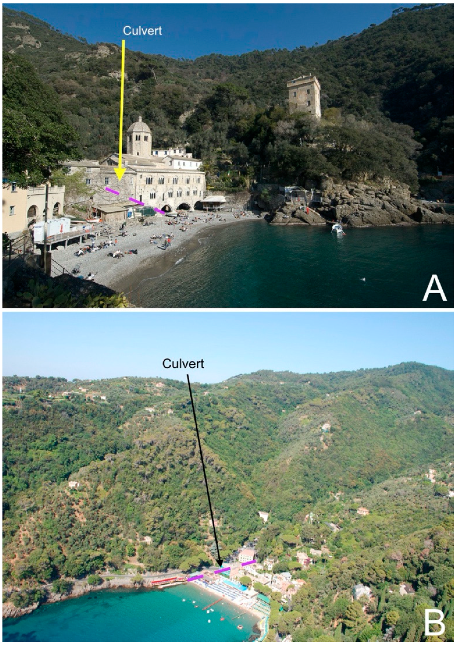
  39. Faccini, F.; Piccazzo, M.; Robbiano, A. Natural hazards in San Fruttuoso of Camogli (Portofino Park, Italy): A case study of a debris flow in a coastal environment. Boll. Della Soc. Geol. Ital. 2009, 128, 641–654. [Google Scholar]
  40. Roccati, A.; Paliaga, G.; Luino, F.; Faccini, F.; Turconi, L. Rainfall Threshold for shallow landslides initiation and analysis of long-term rainfall trends in a Mediterranean area. Atmosphere 2020, 11, 1367. [Google Scholar] [CrossRef]
  41. Sofia, G.; Bailly, J.S.; Chehata, N.; Tarolli, P.; Levavasseur, F. Comparison of pleiades and LiDAR digital elevation models for terraces detection in farmlands. IEEE J. Sel. Top. Appl. Earth Obs. Remote Sens. 2016, 9, 1567–1576. [Google Scholar] [CrossRef] [Green Version]
  42. Saez, J.L.; Corona, C.; Stoffel, M.; Rovéra, G.; Astrade, L.; Berger, F. Mapping of erosion rates in marly badlands based on a coupling of anatomical changes in exposed roots with slope maps derived from LiDAR data. Earth Surf. Processes Landf. 2011, 36, 1162–1171. [Google Scholar] [CrossRef]
  43. De Tomasi, F.; Martano, P.; Miglietta, M.; Morabito, A.; Perrone, M.R. Lidar monitoring of water vapor and comparison with numerical simulations. Il Nuovo Cim. C 2003, 26, 373–385. [Google Scholar]
  44. Samodra, G.; Ramadhan, M.F.; Sartohadi, J.; Setiawan, M.A.; Christanto, N.; Sukmawijaya, A. Characterization of displacement and internal structure of landslides from multitemporal UAV and ERT imaging. Landslides 2020, 17, 2455–2468. [Google Scholar] [CrossRef]
  45. Ilinca, V.; Șandric, I.; Chițu, Z.; Irimia, R.; Gheuca, I. UAV applications to assess short-term dynamics of slow-moving landslides under dense forest cover. Landslides 2022, 19, 1717–1734. [Google Scholar] [CrossRef]
  46. Cebulski, J. Impact of river erosion on variances in colluvial movement and type for landslides in the Polish Outer Carpathians. Catena 2022, 217, 106415. [Google Scholar] [CrossRef]
  47. Freeman, G.T. Calculating Catchment Area with Divergent Flow Based on a Regular Grid. Comput. Geosci. 1991, 17, 413–422. [Google Scholar] [CrossRef]
  48. Furze, S.; O’Sullivan, A.M.; Allard, S.; Pronk, T.; Curry, R.A. A High-Resolution, Random Forest Approach to Mapping Depth-to-Bedrock across Shallow Overburden and Post-Glacial Terrain. Remote Sens. 2021, 13, 4210. [Google Scholar] [CrossRef]
  49. Klemen, Z.; Oštir, K.; Kokalj, Z. Sky-view factor as a relief visualization technique. Remote Sens. 2011, 3, 398–415. [Google Scholar]
  50. Kokalj, Ž.; Hesse, R. Airborne Laser Scanning Raster Data Visualization: A Guide to Good Practice; Založba ZRC: Ljubljana, Slovenia, 2017; pp. 1–90. [Google Scholar]
  51. Heipke, C.; Mayer, H.; Wiedemann, C.; Jamet, O. Automated reconstruction of topographic objects from aerial images using vectorized map information. Int. Arch. Photogramm. Remote Sens. Spec. Inf. Sci. 1997, 23, 47–56. [Google Scholar]
  52. Cohen, J. A coefficient of agreement for nominal scales. Educ. Psychol. Meas. 1960, 20, 37–46. [Google Scholar] [CrossRef]
  53. Cevasco, A.; Pepe, G.; Brandolini, P. The influences of geological and land use settings on shallow landslides triggered by an intense rainfall event in a coastal terraced environment. Bull. Eng. Geol. Environ. 2014, 73, 859–875. [Google Scholar] [CrossRef]
  54. Paliaga, G.; Faccini, F.; Luino, F.; Turconi, L. A spatial multicriteria prioritizing approach for geo-hydrological risk mitigation planning in small and densely urbanized Mediterranean basins. Nat. Hazards Earth Syst. Sci. 2019, 19, 53–69. [Google Scholar] [CrossRef] [Green Version]
  55. Moreno-de-las-Heras, M.; Lindenberger, F.; Latron, J.; Lana-Renault, N.; Llorens, P.; Arnáez, J.; Romero-Diaz, A.; Gallart, F. Hydro-geomorphological consequences of the abandonment of agricultural terraces in the Mediterranean region: Key controlling factors and landscape stability patterns. Geomorphology 2019, 333, 73–91. [Google Scholar] [CrossRef]
  56. Parodi, A.; Ferraris, L.; Gallus, W.; Maugeri, M.; Molini, L.; Siccardi, F.; Boni, G. Ensemble cloud-resolving modelling of a historic back-building mesoscale convective system over Liguria: The San Fruttuoso case of 1915. Clim. Past 2017, 13, 455–472. [Google Scholar] [CrossRef] [Green Version]
  57. Tarolli, P.; Pijl, A.; Cucchiaro, S.; Wei, W. Slope instabilities in steep cultivation systems: Process classification and opportunities from remote sensing. Land Degrad. Dev. 2021, 32, 1368–1388. [Google Scholar] [CrossRef]
  58. Kumar, P.; Debele, S.E.; Sahani, J.; Rawat, N.; Marti-Cardona, B.; Alfieri, S.M.; Basu, B.; Basu, A.S.; Bowyer, P.; Charizopoulos, N.; et al. An overview of monitoring methods for assessing the performance of nature-based solutions against natural hazards. Earth-Sci. Rev. 2021, 217, 103603. [Google Scholar] [CrossRef]
Figure 1. (A): A geographical sketch of the studied area; the numbers show the small catchments and colored boxes are references for figures 5, 6, 8, 9. (B): The slope gradient in the area.
Remotesensing 14 03586 g001
Figure 2. Geological–geomorphological sketch. 1: Alluvial deposits; 2: gravity-induced deposits; 3: conglomerates with sandstone layers; 4: marly limestones, clayey marls and marls; 5: stream; 6: downcutting talweg with occasional debris flow; 7: landslide edge and scarp; 8: scarp edge due to wave erosion; 9: active landslide; 10: dormant landslide; 11: road; 12: culvert; 13: studied catchments.
Remotesensing 14 03586 g002
Figure 3. The methodological workflow: 1. Localization of stone-wall basis through the application of three algorithms; 2. The theoretical surface without terraces is obtained through the basis interpolation; 3. Terrace volume is obtained through DoD between the terraced surface and the interpolated one.
Remotesensing 14 03586 g003
Figure 4. Terraces in the case study area: (A) not maintained in Paraggi catchment (n. 8 in Figure 1) close to the stream, and (B) partially maintained in San Fruttuoso (Figure 1, catchment n. 3).
Remotesensing 14 03586 g004
Figure 5. The approach for the volume calculation. (a): Terraced surface with the dry-stone wall’s basis identification (red lines); (b): the theoretical surface obtained through the interpolation of wall’s basis; (c): the profile along the AA’ lines comparing surfaces 1 and 2; (d): the DTM of differences obtained by subtracting surface 2 from 1.
Remotesensing 14 03586 g005
Figure 6. Terrace identification error assessment (refer to Figure 1). (A) The green-bordered polygons show the test areas: in the southern one, terraces are present, while in the northern one, terraces are absent. The other figure parts show terrace features obtained through the three methodologies: in (B) SKF, in (C) LUC and in (D) LIHA.
Remotesensing 14 03586 g006
Figure 7. The 3D model showing the detection of terraces in the subarea in the blue box (α) in Figure 1. (A): the orthophotography; (B): the sky-view factor (SKF) visualization; (C): both sky-view factor and LUC; (D): both sky-view factor and LIHA.
Remotesensing 14 03586 g007
Figure 8. Comparison of the detailed areas in the box: Figure 1: (A) orthophotography; (B) SKF; (C) LUC; (D) LIHA.
Remotesensing 14 03586 g008
Figure 9. The detected terraces after the application of SKF, LUC and LIHA analyses. The yellow areas indicate the sample slopes used in the volume calculation.
Remotesensing 14 03586 g009
Figure 10. A detail (see green box in Figure 1) of terraced areas, sample ones and dry-stone wall basis in San Fruttuoso.
Remotesensing 14 03586 g010
Figure 11. (A): Terraces’ specific volume and slope class (for slope classes, refer to Figure 1) for the 32 sample areas. (B): The relationship between total volume and surface of the sample areas.
Remotesensing 14 03586 g011
Figure 12. The spatial relationships between terraced areas and cultural heritage, buildings and roads at the mouth of the main studied catchments: (A) in San Fruttuoso and (B) Paraggi catchments (see orange boxes in Figure 1).
Remotesensing 14 03586 g012
Figure 13. Culverts at the mouth of (A) San Fruttuoso (Figure 1, catchment n. 3) and (B): Paraggi (Figure 1, catchment n. 8).
Remotesensing 14 03586 g013
Table 1. Vector-based data used; source is from Regione Liguria authority.
NameScale/PixelDate
Buildings, Manufacts and Walls (CTR, 2nd Ed. 3D)1:50002007
Hydrographic Network and Catchments1:10,0002019
Lithology1:10,0002017
Nature Reserve Borders1:10,0002019
Road Network—CTR 2nd Ed. 3D1:50002007
Slope1:10,0002016
Trail Network1:25,0002020
Table 2. Quality index and Cohen’s K coefficient for the three terraces’ identification methods.
MethodQK
SKF0.8610.696
LUC0.9060.812
LIHA0.9540.932
Table 3. Main features of the small catchments and percentage of terraced areas: Q Mean = mean altitude; Q Max = maximum altitude; Mean G = mean slope gradient.
Catchment Nr.Area (m2)Q Mean (m)Q Max (m)Mean G (%)Terraced Area (%)
141,232118239862.0
278,0861262857611.9
3574,300305600782.3
4494,6643275376614.5
5107,611229393784.0
669,427159332777.8
734,288123269768.7
81,513,5441244775244.4
Table 4. Terraces’ mean specific volume (SV) and mean weighted specific volume (WSV) for the sampled slopes in Paraggi and San Fruttuoso areas.
AreaSV (m3/m2)WSV (m3/m2)
Paraggi0.420.45
San Fruttuoso0.430.39
Table 5. The total amount of debris and soil trapped in terraces in the eight studied small catchments.
Catchment Nr.Debris and Soil in Terraces (m3)Catchment Specific Volume (m3/m2)
13230.008
236280.046
351590.009
428,0020.057
516890.016
621150.030
711620.034
8302,3740.200
Publisher’s Note: MDPI stays neutral with regard to jurisdictional claims in published maps and institutional affiliations.

