Abstract
This study examines uncertainties in the retrieval of the Aerosol Optical Depth (AOD) for different aerosol types, which are obtained from different satellite-borne aerosol retrieval products over North Africa, California, Germany, and India and Pakistan in the years 2007–2019. In particular, we compared the aerosol types reported as part of the AOD retrieval from MODIS/MAIAC and CALIOP, with the latter reporting richer aerosol types than the former, and from the Ozone Monitoring Instrument (OMI) and MODIS Deep Blue (DB), which retrieve aerosol products at a lower spatial resolution than MODIS/MAIAC. Whereas MODIS and OMI provide aerosol products nearly every day over of the study areas, CALIOP has only a limited surface footprint, which limits using its data products together with aerosol products from other platforms for, e.g., estimation of surface particulate matter (PM) concentrations. In general, CALIOP and MAIAC AOD showed good agreement with the AERONET AOD (r: 0.708, 0.883; RMSE: 0.317, 0.123, respectively), but both CALIOP and MAIAC AOD retrievals were overestimated (36–57%) with respect to the AERONET AOD. The aerosol type reported by CALIOP (an active sensor) and by MODIS/MAIAC (a passive sensor) were examined against aerosol types derived from a combination of satellite data products retrieved by MODIS/DB (Angstrom Exponent, AE) and OMI (Aerosols Index, AI, the aerosol absorption at the UV band). Together, the OMI-DB (AI-AE) classification, which has wide spatiotemporal cover, unlike aerosol types reported by CALIOP or derived from AERONET measurements, was examined as auxiliary data for a better interpretation of the MAIAC aerosol type classification. Our results suggest that the systematic differences we found between CALIOP and MODIS/MAIAC AOD were closely related to the reported aerosol types. Hence, accounting for the aerosol type may be useful when predicting surface PM and may allow for the improved quantification of the broader environmental impacts of aerosols, including on air pollution and haze, visibility, climate change and radiative forcing, and human health.
1. Introduction
Aerosols are small liquid or solid particles suspended in the atmosphere [1]. They can be emitted directly to the atmosphere (e.g., dust, sea salt, black carbon (BC), and volcanic aerosols) or formed through atmospheric chemical reactions (e.g., sulfates, nitrates, ammonium, and secondary organic aerosols). Aerosols can be classified into different types based on their sources and chemical composition, with aerosol classification taking many forms. For example, for the purpose of air quality management, aerosols are broadly classified into anthropogenic particles (i.e., of urban/industrial or human-related biomass-burning origin) or natural/biogenic particles (i.e., desert dust, sea salt, volcanic ash, etc.). Alternatively, for the purpose of estimating the aerosol radiative forcing, aerosols are broadly classified into absorbing or non-absorbing/scattering particles. It is noteworthy that the role of aerosols in the energy balance of Earth is more complex than this binary classification, which accounts only for the aerosol direct radiative forcing. Specifically, absorbing aerosols can heat the lower troposphere and suppress convection and cloud formation, which is designated the aerosol semi-direct effect, and aerosols, in general, affect cloud processes, modifying cloud cover, cloud liquid water content (LWC), cloud height, depth, opacity, lifetime, reflectivity, and the cloud droplets’ size distribution, collectively termed aerosol indirect radiative forcing effect [2,3,4]. Due to the aerosols’ highly variable properties, their direct, indirect, and semi-direct effects, and their varied nature as cloud condensation nuclei (CCN) or ice-nucleation particles (INP) are considered the largest source of uncertainty in global radiative forcing estimates [5].
Desert regions (e.g., North Africa and the Middle East), industrial regions (e.g., Europe, North America, and South Asia), and regions that are characterized by considerable biomass-burning (e.g., South Asia, South Africa, and South America) may experience high particle mass concentrations [6,7,8,9], but the aerosol particles in these regions often have distinct compositions and varied physicochemical and optomechanical properties [10]. In particular, the scattering and absorption properties of aerosol particles can be quantified in terms of the Single Scattering Albedo (SSA) and the Aerosols Index (AI). Sulfates, nitrates, ammonium, and sea-salt particles are examples of purely scattering aerosols, whereas absorbing ambient aerosols are primarily particles that contain black carbon (BC). Dust and organic carbon particles are partially absorbing in the ultraviolet (UV) spectral range [11]. High aerosol concentrations have distinct effects on visibility, transport and dispersion of nutrients as part of biogeochemical cycles, and human health, including mortality and many other health outcomes [12,13,14,15,16,17,18]. It is therefore clear that accounting for the aerosol properties is essential for the reliable assessment of their radiative forcing and toxic/health risks on both the global and local scales [19,20,21,22]. Moreover, examining the aerosol properties may enable allocating aerosols to their source regions, emission sectors (industry, traffic, etc.), the type of fuel used (gasoline/diesel, biomass/coal), and the combustion phase (i.e., burning vs. smoldering; [23]). Yet, in spite of its importance, the aerosol type reported as part of the AOD retrieval is rather vague, and as such can result in a plethora of diverse radiative forcing [20,24,25] and health [21,22,26] effects.
Various methods have been proposed for estimating the aerosol type from satellite observations based on the aerosol optical and microphysical properties. The magnitude of the AOD and its spectral variation (i.e., the Ångström Exponent, AE) are common remotely sensed aerosol products that have been widely used to infer the dominant aerosol type, given general familiarity with the source regions and with typical aerosol transport mechanisms and processes [27]. With the continuous improvement in satellite measurement capabilities, an increased number of aerosol products are now available for studying aerosol properties. Based on these properties many studies have demonstrated the classification of aerosols into natural vs. anthropogenic aerosol, with the observations derived from either ground-based or satellite-borne passive-sensor measurements, e.g., Moderate Resolution Imaging Spectroradiometer (MODIS) [28,29,30,31]. Clearly, combining aerosol products retrieved by different instruments, such as Cloud-Aerosol Lidar with Orthogonal Polarization (CALIOP)—an active instrument onboard Cloud-Aerosol Lidar and Infrared Pathfinder Satellite Observations (CALIPSO), and Ozone Monitoring Instrument (OMI)—a passive instrument onboard Aura, have the potential to further enhance the aerosol type classification.
One of the challenges of the satellite-based passive remote sensing of aerosol properties is the separation of the path radiance, referring to molecular (Rayleigh) and airborne particles (Mie) scattering, from the top-of-the-atmosphere (TOA) radiance, which accounts also for reflection from the surface. The path radiance varies with the scene parameters (e.g., the aerosol loading, size and composition; cloud cover and properties) as well as with the retrieval parameters (e.g., view angle and field of view). Once the surface reflection is isolated, the path radiance is used for estimating the aerosol properties [32,33]. Hence, retrievals by passive sensors need to estimate the surface reflectance. In contrast, retrievals by active sensors (e.g., CALIOP) do not require to estimate the surface reflectance as they utilize range-resolved (i.e., height-resolved) measurements of the integrated attenuated backscatter and of the volume depolarization ratio [34,35]. As such, CALIOP can retrieve the aerosol type by height [36]. Consequently, while CALIOP retrieval algorithm reports seven aerosol types (dusty marine, dust, polluted dust, clean continental, polluted continental/smoke, and elevated smoke), the spectral surface bidirectional reflectance distribution function (BRDF) enables the Multi-Angle Implementation of Atmospheric Correction (MAIAC) algorithm to identify only absorbing aerosols (smoke and dust) and to successfully delineate dust plumes from clouds even above bright (desert) background [37].
In this study, we examine reported aerosol types from MODIS/MAIAC and CALIOP against OMI and MODIS/Deep Blue (DB) aerosol products over North Africa (NA), California (CA), Germany (GR), and South Asia (SA). These geographical regions are characterized by considerable differences in the aerosol properties and sources [9]. Accounting for aerosol properties based on cross-platform MODIS/DB AE and OMI AI, with both products characterized by complete spatial coverage unlike the CALIOP data products, enables to examine richer aerosol types based on independent size (coarse, fine, and mixed sized) and optical (absorbing, scattering, and neutral) measurements.
2. Data and Methods
Data from three satellite sensors, MODIS (both MAIAC and DB retrieved products), CALIOP, and OMI, were used in this study, together with ground measurements from 19 AErosol RObotic NETwork (AERONET) sites (Tables S1 and S2). We used these data products to compare the estimated aerosol types of the retrieved atmospheric aerosols. Records from the years 2007–2019 were used.
2.1. Study Areas
The study areas include North Africa (NA: Morocco, Algeria, and Tunisia), California (CA), Germany (GR), and South Asia (SA: India and Pakistan). These study areas were chosen since they are characterized by different aerosol sources, which are mapped into varied and varying aerosol types [9,38]. The primary aerosol sources in South Asia are the resuspension of crustal matter (dust); emissions from industry, power plants, vehicles, and construction activities; and biomass combustion and waste burning [8]. The source profiles vary widely across SA and between the seasons [8]. In North Africa, the world’s largest source of mineral dust, lifting/resuspension and transport of windblown dust is the dominant aerosol source [7]. In Germany, the primary source of aerosols is the combustion of fuels by traffic, industry, and the energy sector, but also from household/domestic use [39]. In California, the main aerosol sources include combustion of fuels: gasoline and diesel by traffic and wood due to natural forest fires and domestic use; resuspension of crustal material; and sea spray [6].
2.2. CALIOP/CALIPSO Aerosol Products
The Cloud-Aerosol Lidar Infrared Pathfinder Satellite Observations (CALIPSO) satellite was launched in April 2006 and provides an opportunity to study clouds and aerosols using range-resolved laser remote sensing. The primary payload aboard CALIPSO is the Cloud-Aerosol Lidar with Orthogonal Polarization (CALIOP), a dual wavelength polarization-sensitive backscatter lidar that measures vertical profiles of the spatial and optical characteristics of clouds and aerosols in the Earth’s atmosphere [40]. Using two 532 nm receiver channels and a channel measuring the total 1064 nm return signal, CALIOP can measure in detail the vertical distribution of aerosols and clouds along with their microphysical and optical properties. In particular, due to its active measurement CALIOP (unlike passive measurement, e.g., MODIS) can observe aerosols during day and night, over bright surfaces, and beneath thin clouds [41]. CALIOP V4 level 2 data products include seven aerosol subtypes in the troposphere: clean marine (CM), dusty marine (DM), dust (DD), polluted dust (PD), clean continental (CC), polluted continental/smoke (PC/S), and elevated smoke (ES). In addition, CALIOP also reports four aerosol subtypes in the stratosphere (volcanic ash, smoke, sulfate/other, and polar stratospheric aerosol; [36,42]). In this work, we accounted only for the tropospheric aerosol subtypes. Moreover, throughout this work, we only refer to five CALIOP aerosol subtypes, since both the clean marine (CM) and clean continental (CC) subtypes were never reported in any of the study areas during the whole study period.
The CALIOP aerosol subtype classification utilizes measurements of the depolarization ratio, integrated attenuated backscatter coefficient, surface radiance, and information on the aerosol layer height [41,42]. Specifically, the depolarization ratio is used for assessing the particle non-sphericity, thus to distinguish between dust (non-spherical absorbing) and smoke (spherical absorbing) particles. The integrated attenuated backscatter coefficient is used to estimate the aerosol layer height, with elevated aerosol layers characterized by molecular scattering from both above and below them. It is noteworthy that multiple scattering is not accounted for and can introduce uncertainty when optically thick layers are present. The aerosol lidar ratio is a key parameter in AOD retrieval and aerosol type classification [42,43], and has been determined for each aerosol subtype based on measurements, modeling, and a cluster analysis of multiyear AErosol RObotic NETwork (AERONET) datasets [36]. Here, we used CALIPSO Version 4.20 Level 2 aerosol products (https://subset.larc.nasa.gov/calipso/login.php).
2.3. MODIS MAIAC Aerosol Products
The MODIS instrument onboard both Terra and Aqua measures the TOA radiance in 36 wavebands at spatial resolution that ranges from 250 m to 1 km, depending on the spectral band and the sensor viewing angle. In this work, we used aerosol products retrieved only from MODIS on-board Aqua, which is one of satellites in the A-train constellation. MAIAC is a relatively new operational algorithm that retrieves aerosol properties and columnar water vapor (CWV) at 1 km spatial resolution over land (except for snow and ice) and ocean. The collection 6 (C6) MODIS/MAIAC algorithm provides daily AOD retrievals using the dust model if dust has been detected. Alternatively, the AOD is retrieved using a regional background model even if smoke has been detected but for very high aerosol loading [9]. MAIAC has eight regional aerosol models (background aerosol types; [37]) that were developed based on long-term AERONET aerosol climatology. The models’ properties include the aerosol volumetric size distribution (radii and geometric standard deviations of the fine and coarse modes), the modal concentration ratio, the complex refractive index, and the absorption Ångström exponent (AAE). The aerosol models are either static (i.e., with fixed parameters and typical of arid environments) or dynamic (i.e., with parameters that depend on the retrieved AOD; [29]). The variation of the parameters of the volumetric size distribution with the retrieved AOD mainly represents the hygroscopic growth of aerosol particles in the tropical regions, during the rainy season [8,44], or in regions that are characterized by moderate-to-high humidity.
Several reasons make MAIAC significantly superior over other operational MODIS algorithms: (a) the high spatial resolution (1 km) compared to other operational MODIS aerosol products based on the Dark Target (DT) and the Deep Blue (DB) algorithms (10 and 3 km), which allows to distinguish fine spatial features and enhance the spatial coverage [44]. (b) High retrieval accuracy over both dark and bright surfaces, and (c) MAIAC’S capability to retrieve AOD while reporting different aerosol types, i.e., discriminating among absorbing fine (smoke) and coarse (dust) aerosols [37]. In this study, the 2007–2019 daily 1 km clear-sky Aqua MODIS/MAIAC AOD at 550 nm over the study areas was used (https://ladsweb.modaps.eosdis.nasa.gov/).
2.4. MODIS Deep Blue Aerosol Products
The MODIS DB algorithm (10 km spatial resolution) was originally developed to retrieve AOD over bright surfaces, such as deserts, utilizing the 412 and/or 470/650 nm wavelengths depending on the surface type [45,46]. The C6+ DB algorithm extends retrievals to green and dark surfaces and enables global AOD retrieval except over snow and ice. Over vegetated surfaces, the DB algorithm uses statistical spectral ratios as a function of the Normalized Difference Vegetation Index (NDVI) for determining the surface reflectance. Over bright surfaces, it relies on a static seasonal database of spectral surface reflectance, binned based on the viewing geometry and derived from MODIS measurements of previous years, based on the minimum reflectance method. The DB algorithm selects the aerosol model as a function of the geographical region and the season. The AOD and the AE are retrieved for fine and mixed aerosols, while AOD and the Single Scattering Albedo (SSA) are retrieved when coarse aerosol (i.e., dust) is detected. The latest version of Aqua MODIS (C6.1) DB/AE with quality flag QA > 2 was used for classifying the aerosol type, following [47]. In this study, we used the 2007–2019 MYD04_L2 data over the study areas (https://ladsweb.modaps.eosdis.nasa.gov/search/).
2.5. OMI Products
OMI was launched in July 2004 on NASA’s Earth Observing Satellite (EOS)-Aura, which is also one of the A-train constellation satellites. OMI is a hyperspectral imaging spectrometer that measures the TOA solar backscatter irradiance in the UV-Vis spectrum range (264–504 nm; [33]). Its capability of measuring near-UV aerosol properties enables OMI to report the UV-Aerosol Index (AI), which has been widely used to project global/regional distribution of UV-absorbing aerosols, such as carbonaceous aerosols, desert dust and volcanic ash [48,49,50,51,52]. Normally, dust is the main contributor to the AI signal [53], since ozone absorption in the measured UV range is negligible. The AI (positive values represent absorbing aerosols and negative values represent scattering aerosols) is calculated by OMI’s near-UV aerosol retrieval algorithm (OMAERUV) and is used in combination with the retrieved AOD [49,54,55]. In this study, we used Aura/OMI Near UV Aerosol Optical Depth and Single Scattering Albedo Daily L2 Global Gridded 0.25° × 0.25° V3 (OMAERUVG; Version 3 Level 2 (L2G) AAOD; https://search.earthdata.nasa.gov/searc).
2.6. AERONET Data
AERONET is a worldwide ground-based sun photometer network that provides columnar aerosol optical properties at a high temporal resolution (AOD: 5–15 min, sky radiance: 30 min) and at a number of wavelengths (0.34, 0.38, 0.44, 0.67, 0.87, and 1.02 µm) [56,57]. Since the measurements are conducted from the surface upwards, they are considered to be representative of the aerosol properties near the surface, e.g., in the atmospheric boundary layer (ABL). In addition to spectral AOD, AERONET stations report the Ångström Exponent (AE), Single Scattering Albedo (SSA), and the observed percentage of spherical particles. The AE is used to derive information on the aerosol size distribution whereas the spectral dependence of the SSA (the ratio of scattering to total extinction) provides information on the abundance and size of absorbing/scattering aerosols [56,57]. In this paper, we used AERONET Version 3 Level 2.0 (V3 L2) data, collected at 19 AERONET sites across the study areas in the years 2007–2019 (Figure 1, Table S1) (https://aeronet.gsfc.nasa.gov/cgi-bin/webtool_aod_v3), with the sites located in urban areas but not surrounded by irregular or complex terrain. The V3 L2 AERONET AOD data are quality assured and, therefore, the retrieval bias is assumed to be very small compared to the bias of satellite based AOD retrieval [58]. Hence, it is common to consider the AERONET AOD as a ground-truth AOD. The availability of AERONET data varied among the stations. AERONET Version 3 Level 2.0 quality-controlled AOD data were compared to MODIS AOD. For this, the AERONET AOD at 500 nm was interpolated to 550 nm using AE based on the 440 nm and 675 nm wavelength pair.
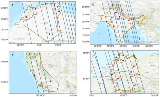
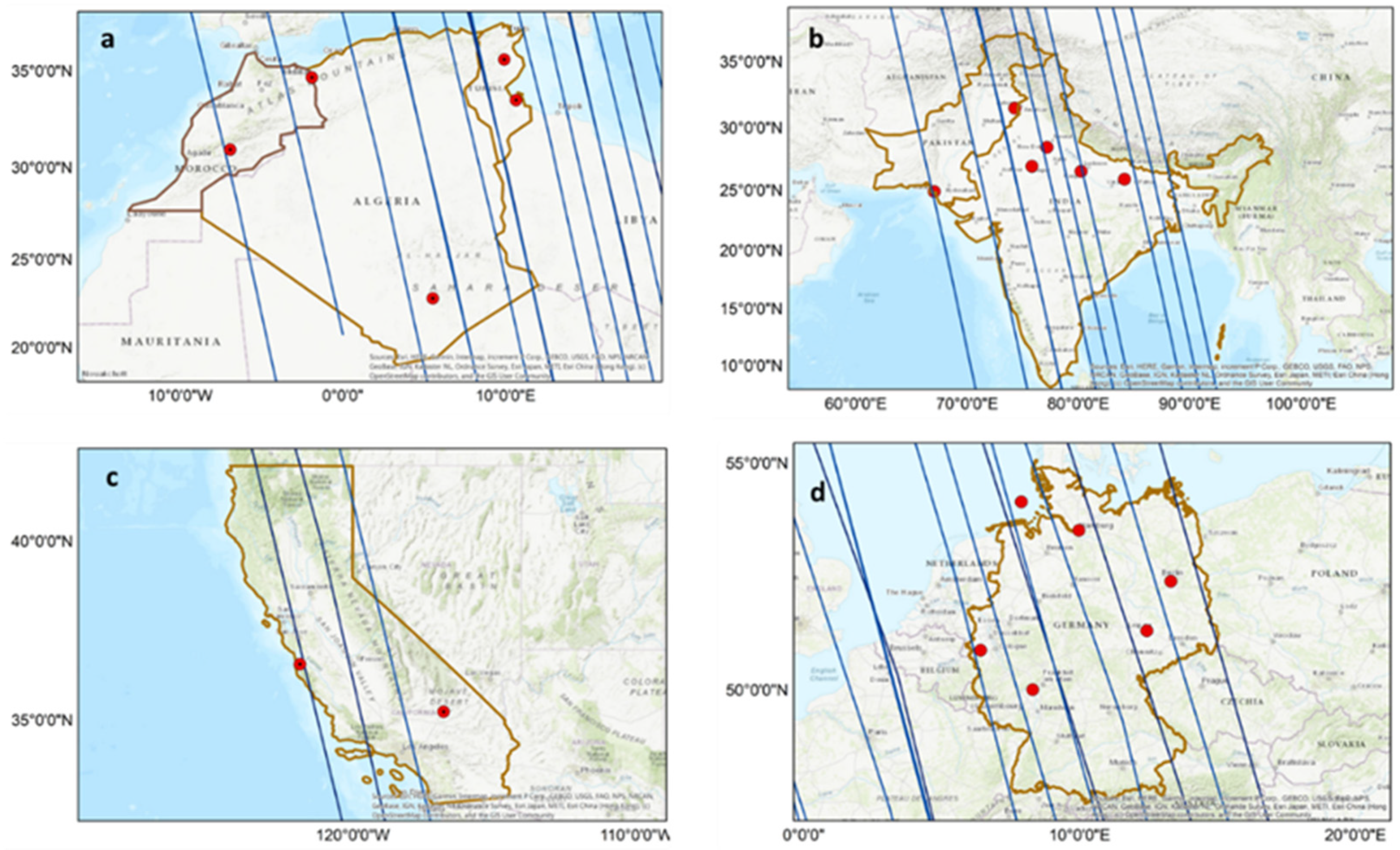
Figure 1.
The geographic distribution of the AERONET stations (red dots) across the study areas ((a)—North Africa, (b)—South Asia, (c)—California, and (d)—Germany). The blue lines are the CALIPSO paths over the study areas.
3. Methodology
3.1. Performance of Retrieved Aerosol Products
The MAIAC AOD is retrieved at 550 nm, the CALIOP AOD is retrieved at 532 nm, and the AERONET Direct Sun AOD is reported at 440 nm, 500 nm, 675 nm, and 870 nm. To enable coherent analyses of the various datasets used in this work, and based on our previous study [9], the AERONET AOD500 was transformed into AOD550 using the AERONET co-measured AE, calculated based on the 440 nm and 675 nm wavelength pair [59]. The AERONET AOD was averaged over a temporal window of 15 min, while the MAIAC and CALIOP AOD were averaged over a spatial window of 0.5° × 0.5° centered at the AERONET site.
The following statistical metrics were used for evaluating the AOD retrieval, accounting for the varying number of collocations, N (Figure 2): Pearson’s correlation coefficient (r); the root-mean-square error (RMSE), calculated as the square root of the reduced chi-squared and representing the variability in the data:
and the relative mean bias (RMB):
with RMB > 1 indicating overestimation and RMB < 1 representing underestimation with respect to the ground truth.
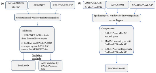
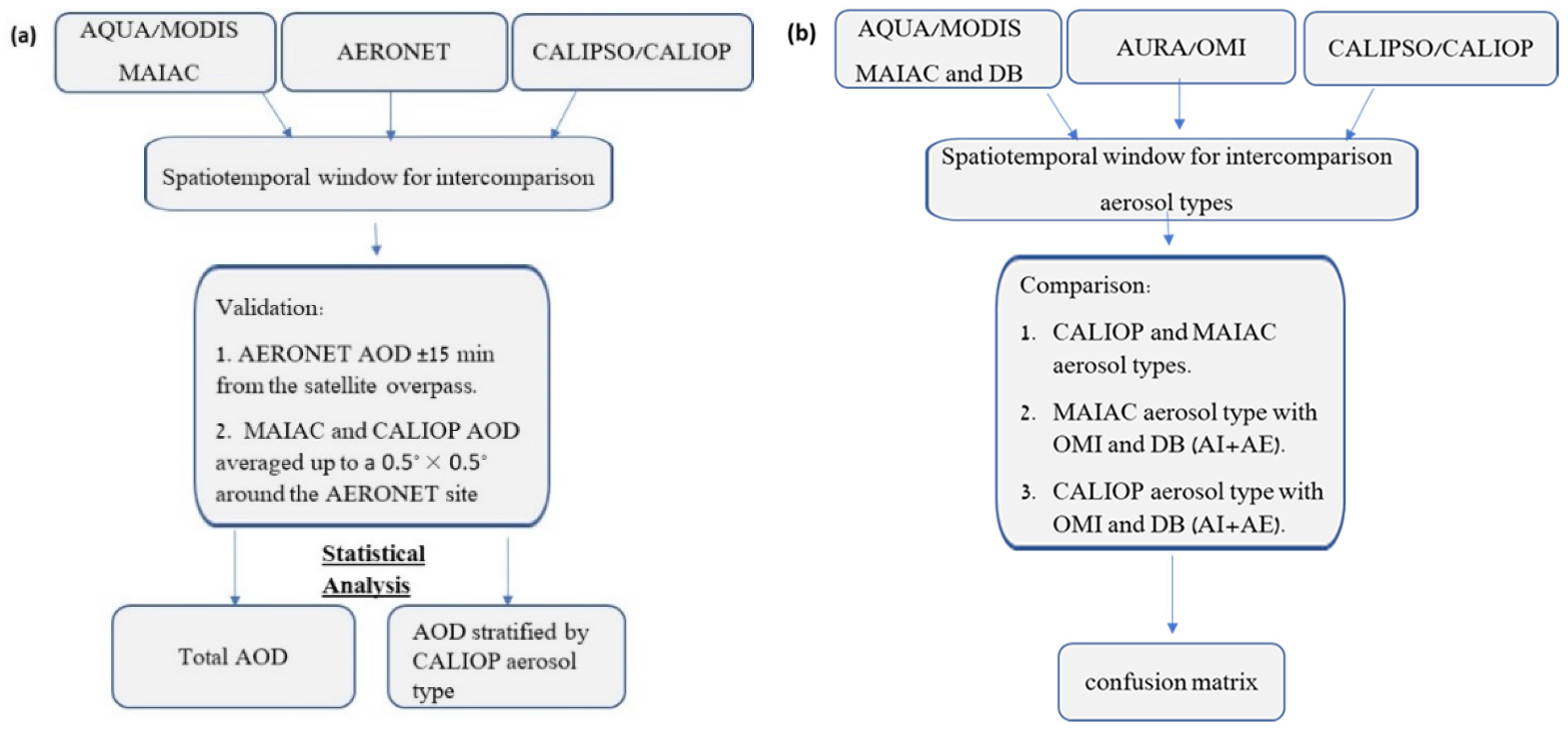
Figure 2.
Flowchart of the performance evaluation of MAIAC and CALIOP AOD retrieval (a) and aerosol type estimation (b).
3.2. Aerosol Type Classification
Classification of the aerosol type can be achieved using different combinations of satellite-borne aerosol products. Using confusion matrixes, the quality of the aerosol type classification was examined by comparing the CALIOP retrieved aerosol sub-types against MODIS/MAIAC and OMI aerosol type classifications in each study area, as well as against the MODIS/DB particle size classification. The aerosol type was also examined against site-specific local and regional reported aerosol sources. We averaged the MODIS/MAIAC, CALIOP, and OMI satellite data products over a 0.5° × 0.5° window centered at the AERONET site, with the most frequent aerosol type reported within the retrieval box over the study period taken to be its representative aerosol type.
As mentioned in Section 2.2, CALIOP classifies tropospheric aerosols into seven different aerosol sub-types. Yet, due to CALIOP’s limited spatial cover (narrow footprint) and revisit period (16 days), for practical purposes aerosol types obtained as part of AOD retrievals by sensors that have full cover (Table S2) may be more useful, e.g., for PM2.5 estimation [60,61]. To assess the limited MAIAC aerosol types relative to the richer CALIOP aerosol subtypes, we compared the two classifications. Yet, because of the limited compositional information that is contained in MAIAC’s three aerosol types (Section 2.3) relative to the presumably richer actual aerosols, and as comparisons against CALIOP suffer from limited spatial collocation (i.e., small N), we examined also other co-measured aerosol products that can shed light on the type/source of the observed aerosols.
The coarser approach was to account only for the aerosol particle size distribution in terms of the Ångström exponent. Namely, the AERONET AE based on the 440–870 nm wavelength pair was used to classify the aerosol into a particle populations that are dominated by coarse particles (AE < 0.7, e.g., dust), mixed mode aerosol (0.7 ≤ AE < 1.3), and fine particles (AE ≥ 1.3, e.g., smoke) [9,47,56]. Yet, as AERONET stations are relatively sparse (Figure 1), we examined aerosol size classes based on AE reported by MODIS/DB as part of the retrieval. It is noteworthy that, due to the lack of observations, we could not use the AERONET SSA as an additional feature. In particular, the AERONET SSA is reported by the AERONET inversion algorithm only when the retrieved AOD > 0.4. The abundance of such cases in our database was very small in all the study areas, and especially over California and Germany. This lack of AERONET SSA data instigated us to examine using the OMI AI product for classifying the aerosols as absorbing or scattering. Specifically, OMI’s AI was used to classify aerosols into three categories: AI < −0.25 represents scattering aerosols, −0.25 ≤ AI < 0.25 represents neutral or mixed-type aerosols, and AI ≥ 0.25 represents absorbing aerosols [54,55]. Accounting for both MODIS/DB AE and OMI AI in parallel was examined as a further method for evaluating/interpreting MAIAC’s aerosol types, enabling classification of ambient aerosols into nine unique aerosol types [54]. Only the mean values of the highest quality pixels for which both the OMI AI and the MODIS/DB AE were reported over the study areas were used.
4. Results
4.1. Performance of CALIOP AOD Retrievals
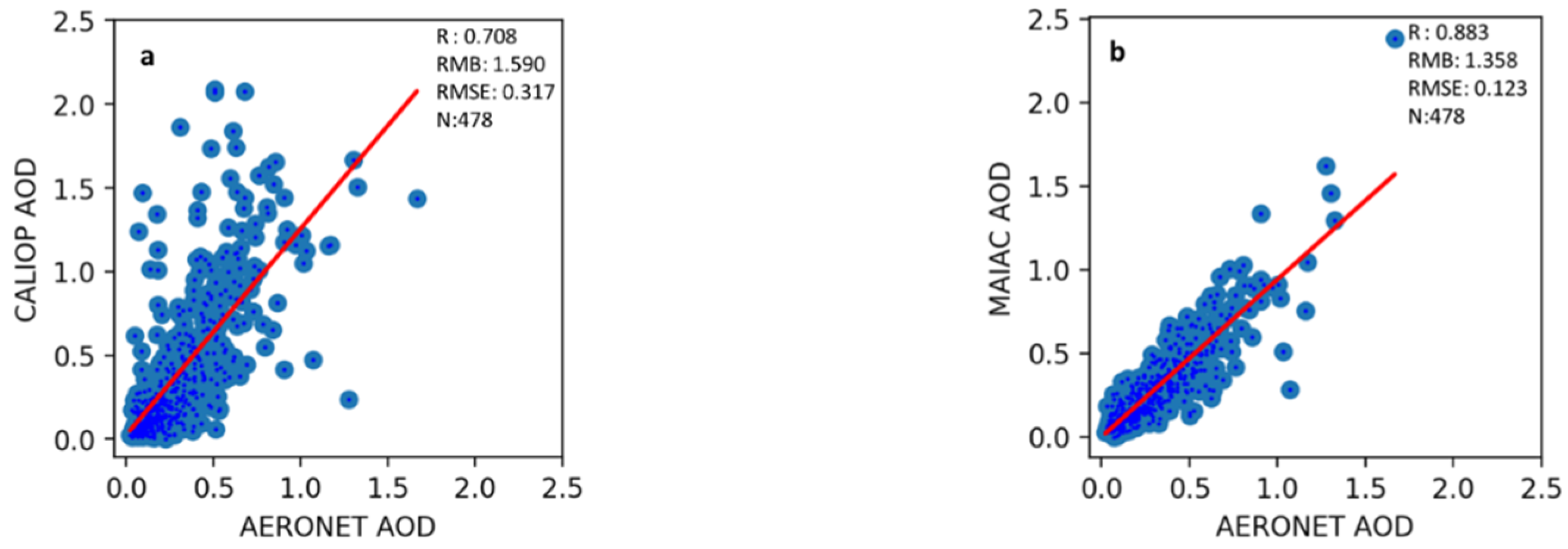
CALIOP AOD was evaluated against AERONET AOD measurements at 19 AERONET sites scattered across the study areas, as well as against collocated MODIS/MAIAC AOD retrieved over these sites (Figure 3). Both CALIOP and MAIAC retrieved AOD were found to be overestimated (RMB: CALIOP–1.57, MAIAC–1.36; Figure 3) with respect to the AERONET AOD. Still, MAIAC AOD showed better agreement (R: 0.883) and lower RMSE (0.12) than CALIOP AOD (R: 0.708, RMSE: 0.32). In fact, CALIOP retrieved higher AOD than MAIAC (RMB: 1.49), especially under higher aerosol loading conditions (AOD > 0.2), possibly due to its sensitivity to the prevailing meteorological conditions, i.e., cloud cover, solar radiation, surface reflectivity, etc. [62]. These results, together with the vast difference in the spatial cover of the two products, support using MAIAC AOD rather than CALIOP AOD in different applications, e.g., estimation of ground-level particulate matter (PM) concentrations.
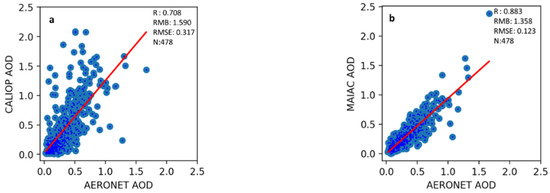
Figure 3.
Scatterplot of (a) CALIOP AOD and (b) MAIAC AOD retrievals against collocated AERONET AOD. The solid red lines represent the linear regression for which the performance measures are shown in each plate: the Pearson’s correlation coefficient (r), the relative mean bias (RMB), and the RMSE.
Possible reasons for the AOD overestimation by both the active (CALIOP) and passive (MODIS) sensors include the underestimation of the surface reflectance, uncertainty in the aerosol model assumptions, and cloud contamination [63]. However, CALIOP observation are expected to be far less affected by surface reflection and cloud contamination than passive sensor data such as MODIS; hence, the uncertainties in CALIOP AOD are probably due to the aerosol models used. Yet, since CALIOP bases its aerosol typing on better information (richer observations) than that used by passive sensors, the CALIOP aerosol subtypes are considered to be more accurate than those derived from passive sensor measurements as well as by AERONET, which does not provide direct aerosol typing and whose SSA data were not available in most AERONET stations on a daily basis (see Section 3.2). Namely, the lower CALIOP AOD performance does not preclude using other aerosol products retrieved by CALIOP (e.g., the aerosol layer height), since the CALIOP aerosol models’ parametrization rather than the aerosol types may need attention.
4.2. Aerosol-Type Impact on AOD Retrievals
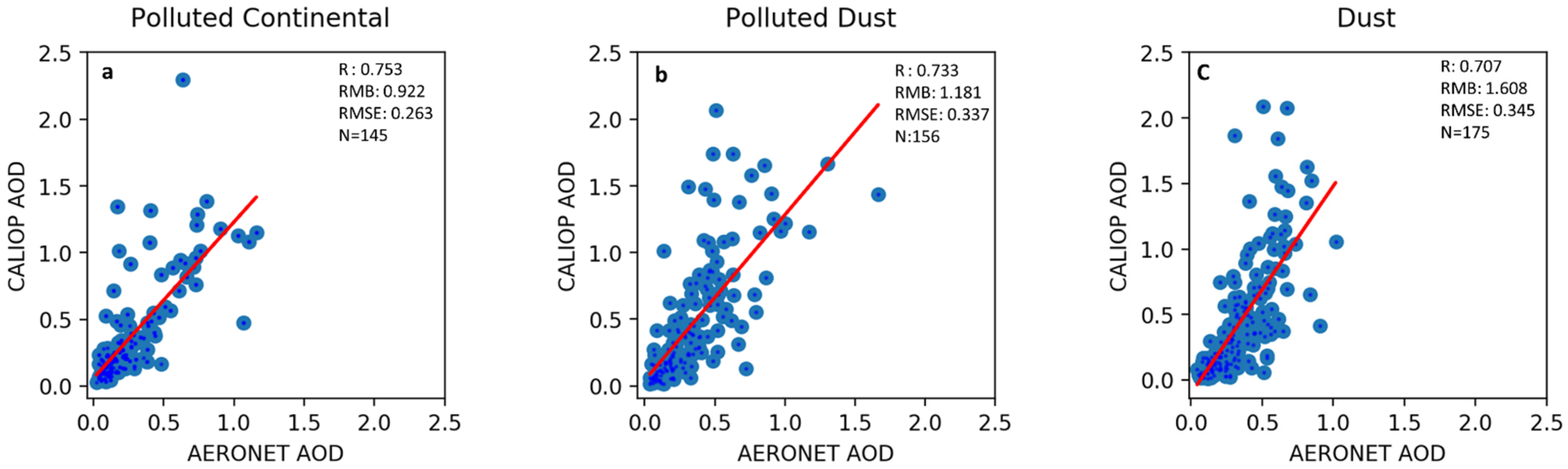
Figure 4 depicts the performance of CALIOP AOD retrievals against AERONET AOD measurements for different CALIOP aerosol subtypes. The Pearson’s correlation coefficient between the AERONET and CALIOP AOD was higher for polluted continental (PC/S) aerosol than for dust (r: DD–0.707; PD–0.733; PC/S–0.753), while the RMSE showed, as expected, the opposite pattern (DD–0.345; PD–0.337; PC/S–0.263). Nonetheless, AOD retrievals for both dust (DD) and polluted dust (PD) aerosol types were still overestimated (RMB: DD–1.608, PD–1.181).

Figure 4.
Scatterplot of CALIOP AOD vs. AERONET AOD for different aerosol types: (a) polluted continental (PC/S), (b) polluted dust (PD), and (c) dust (DD). The red lines are the linear regressions. The performance measures are the Pearson’s correlation coefficient (r), RMSE, and relative mean bias (RMB).
4.3. Aerosol Type Classification
Since the AOD retrieval performance was shown to be affected by the retrieval algorithm selection of the aerosol type (i.e., the aerosol model), to be able (in future studies) to develop improved models for estimating ground PM based on satellite retrieved AOD, we assessed the aerosol type classifications reported by different algorithms as part of the retrieval process. As CALIOP is the only active satellite-borne sensor that observes Earth and can delineate the aerosol vertical distribution and its physicochemical properties, CALIOP data products offer substantial advantages for aerosol research. For example, the CALIOP aerosol subtype observations have been widely used for evaluating chemical transport model simulations [64,65,66,67,68], and for examining the spatiotemporal distribution and transport of major aerosol types, such as dust and smoke [69,70,71,72]. In this work, we compare the CALIOP aerosol subtypes with those reported by the MODIS/MAIAC retrieval algorithm as well as with aerosol type classification based on MODIS/DB AE and OMI AI (see Section 3).
4.3.1. CALIOP and MAIAC Aerosol Types
Unlike CALIOP classification of the retrieved aerosol into seven subtypes (DM, DM, DD, PD, CC, PC/S, and ES; [36,42], the MAIAC aerosol retrieval algorithm classifies aerosols only into three aerosol types, dust (D), smoke (S), and background (B), with the properties of the latter varying in different regions [37]. Figure 5 and Table 1 show that, while both CALIOP and MODIS/MAIAC classified coarse aerosol as dust, CALIOP dust (DD) aerosols had higher mean AERONET AE (0.48 ± 0.38) than the MAIAC dust (D) aerosols (0.35 ± 0.32). Yet, both support a common composition of coarse aerosol fraction [47], i.e., AERONET AE < 0.7. However, solely by itself the AE is a weak aerosol type classifier. As seen in Figure 5, the mean AE of the non-DD CALIOP aerosol types PC/S and ES was high, although both aerosol types are expected to contain smoke, which is composed of fine particles. In fact, the mean AE of these aerosol subtypes was higher than that of the PD and CM aerosol subtypes, which contain mineral dust and sea salt (coarse particle), (PC/S: 1.31 ± 0.41, PD: 1.07 ± 0.45, DM: 1.02 ± 0.45, ES: 1.19 ± 0.56). Similarly, the mean AE for the non-D MAIAC aerosol types was not significantly different (B: 1.05 ± 0.49, and S: 1.14 ± 0.37), although MAIAC reported the aerosol type in most retrievals to be background (B: N = 377, S: N = 10, D: N = 91; Table 1). Moreover, while aerosols that were classified by CALOP as elevated smoke (ES: 1.19 ± 0.56) had very similar mean AE to that of MAIAC’s reported smoke aerosol (S: 1.14 ± 0.37), in spite of the extended study period and the geographical extent of this work the CALIOP ES and DM aerosol types were reported in only very few cases (N = 8 and 37, respectively, out of a total of N = 478 CALIOP retrievals).
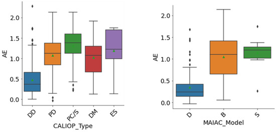
Figure 5.
Boxplots of AERONET AE distributions for different CALIOP (left) and MAIAC (right) aerosol types. CALIOP aerosol types: (DD) dust, (PD) polluted dust, (PC/S) polluted continental/smoke, (DM) dusty marine, and (ES) elevated smoke. MAIAC aerosol types: (D) dust, (B) background, and (S) smoke. Box lower and upper borders represent the 25th and 75th percentiles of the data respectively (i.e., the inter quartile range, IQR). The inner lines are the medians, green triangles are the means, the upper whisker represents the 75th percentile + 1.5 × IQR, and the lower whisker represents the 25th percentile − 1.5 × IQR.

Table 1.
AERONET AE statistics for different CALIOP and MAIAC aerosol types (the overbar represents arithmetic mean).
Table 2 presents the confusion matrixes of the CALIOP-reported aerosol subtypes against MAIAC-reported aerosol types. When accounting for all the study areas together, there is 14% agreement between MAIAC and CALIOP dust classifications, but the agreement between smoke (MAIAC) and elevated smoke (CALIOP) is negligible. Moreover, it is clear that there are considerable disagreements between MAIAC and CALIOP aerosol types across different study areas. For example, in North Africa (NA), MAIAC dust aerosol type is mapped into CALIOP dust (DD: 61.6%), polluted dust (PD: 10.3%), dusty marine (DM: 5.6%), and polluted continental/smoke (PC/S: 3.7%) aerosols. In California (CA) and South Asia (SA), however, these CALIOP aerosol types are mapped into the MAIAC regional background aerosol type (model 2 for CA and model 8 for SA; 46.3% and 77.4%, respectively). In Germany, the MAIAC background aerosol type is often mapped by CALIOP into polluted continental/smoke (PC/S) aerosol (52.78%; Table 2). In general, the classification of the aerosol type as smoke (S) by MAIAC or as elevated smoke (ES) or polluted continental/smoke (PC/S) by CALIOP was found mainly in SA. In other regions, MAIAC smoke (S) was sometimes reported by CALIOP as dusty marine (DM; California, SA), dust (DD; Germany), and polluted dust (PD; SA). This suggests that the MAIAC smoke aerosol model may require fine-tuning. Moreover, it seems that, while the MAIAC background (B) aerosol type may describe well the local aerosol microphysical and optomechanical properties, the generic name does not carry information about the sources or composition of the aerosols, which is necessary for estimating their health effects. In particular, the retrievals of specific aerosol types could be used for estimating ground-level fine PM with different chemical compositions and biological properties (size, solubility, toxicity, bioavailability, etc.), whereas retrievals of a generic background aerosol type, which has a distinct aerosol composition in different regions, requires auxiliary information on the optical, microphysical, and toxicological properties of the common local airborne particles for effective air quality management, for estimating its radiative forcing, or for assessing the risk for the general population and in particular for specific vulnerable sub-groups. As hinted above, despite the benefits that could result from using MAIAC AOD retrievals together with CALIOP aerosol subtype classification, merging these cross-platform aerosol products is not useful due to the limited spatio-temporal footprint of CALIOP. Hence, we resorted to using OMI and MODIS/DB aerosol products to overcome this limitation and obtain information on the aerosol makeup.
Table 2.
Confusion matrixes of aerosol types retrieved by CALIOP and MAIAC (%).
4.3.2. MAIAC and OMI-DB Aerosol Types
Table 3 depicts a comparison between aerosol types reported by MAIAC and aerosol classification based on OMI AI and MODIS/DB AE, with the latter combined product expected to enable a better compositional estimation of the regional/local MAIAC background aerosol type. The global cover of both Aqua/MODIS and Aura/OMI aerosol products resulted in much larger N, and hence improved the reliability of the results. MAIAC AOD retrievals based on the regional-specific background aerosol model in all the study areas (N = 39,932) were classified by the combined OMI-DB procedure into mainly absorbing fine (AF: 23.7%), neutral fine (NF: 24.3%), absorbing coarse (AC: 10.3%), absorbing mixed (AM: 6.4%), neutral mixed (NM: 5.4%), neutral coarse (NC: 3.6%), and scattering fine (SF: 2%) aerosols. However, as expected, it is clear from Table 3 that the MAIAC background aerosol type represents different combinations of aerosol compositions in the different regions, which complicates the source attribution and the classification of the aerosols into aerosol types of interpretable properties.
Table 3.
Confusion matrixes of aerosol types retrieved by MAIAC and OMI-DB (%). The aerosol optomechanical size categories include AC, absorbing coarse; AF, absorbing fine; AM, absorbing mixed size; SC, scattering coarse; SF, scattering fine; SM, scattering mixed size; NC, neutral coarse; NF, neutral fine; and NM, neutral mixed size. Coarse aerosol: AE < 0.7; mixed size aerosol: 0.7 ≤ AE < 1.3; fine aerosol: AE ≥ 1.3. Scattering aerosol: AI < –0.25; neutral (mixed type) aerosol: –0.25 ≤ AI < 0.25; absorbing aerosol: AI ≥ 0.25 (see Section 3.2).
Since the MAIAC background aerosol models have been developed based on regional AERONET climatology, geographic variability in their OMI-DB classification was evident. For example, dust (MAIAC) aerosols dominated over North Africa and were classified as absorbing coarse (AC: 19%), absorbing fine (AF: 13.6%), and neutral fine (NF: 17.1%) aerosols by OMI-BD. As for the MAIAC background aerosol type, California and Germany showed the dominance of fine aerosols based on the OMI-DB aerosol classification (California: AF 35% and NF 26.2%; Germany: AF 24.2% and NF 47.7%), with both the size fraction and the absorbing nature of the particles expected in regions that are characterized by considerable anthropogenic emissions (see Section 2.1). Over South Asia, MAIAC’s reported smoke and background aerosols were mostly mapped as absorbing fine particles (13.2% and 28.6%, respectively). These results emphasize that, while in all the study areas, but North Africa, the dominant aerosol type reported by MAIAC was background, in practice, the aerosol was constituted of different particle composition, as it is suggested by the regional nature of the background models. Hence, without auxiliary information on the typical regional aerosol properties, the MAIAC background aerosol class has limited value, despite its very large number of observations.
4.3.3. CALIOP and OMI-DB Aerosol Types
To provide meaningful names to the aerosol type categorization of MAIAC, we examined the aerosol categories obtained from the combined OMI-DB classification against the CALIOP aerosol subtypes, which in spite of not offering a full spatial cover is considered to provide better aerosol typing due to its active sensor. When analyzing all the study areas together, the dominant aerosol types retrieved by CALIOP (N = 527) were dust (DD: 28.2%), polluted continental/smoke (PC/S: 33.4%), and polluted dust (PD: 25.9%). These cases were mapped by the combined OMI-DB classification mainly as absorbing coarse (AC), neutral fine (NF), and absorbing fine (AF) aerosols, respectively (Table 4). Moreover, in all the study areas except SA, our results suggest that CALIOP DD represents mainly absorbing coarse (AC) particles, whereas the CALIOP PD and PC/S categories represent in all regions mostly absorbing fine (AF) particles. In practice, PD and PC/S probably represent a mixture of smoke/combustion related aerosols (black carbon (BC) and brown carbon (BrC); [73]), secondary aerosols (including sulfates and nitrates), and other non-carbonaceous particles. Moreover, when OMI-DB reports that more than 10% of the aerosols are AM, it seems that these aerosols are dust according to the CALIOP aerosol subtype.
Table 4.
Confusion matrixes of aerosol types retrieved by CALIOP and those obtained from the combined OMI-DB aerosol products (%). (Abs., absorbing; Sca, scattering; Neu, neutral (a mixture of absorbing and scattering); Mixed, an aerosol that contains both fine and coarse particles).
Hence, despite noted regional differences, our results imply that the combined OMI-DB aerosol categories can be mapped onto CALIOP aerosol subtypes as follows: AC and often AM particles represent mostly dust (DD), and AF and NF particles represent mainly polluted dust (PD) and polluted continental/smoke (PC/S), i.e., typical urban aerosols in large metropolitans. Combined with the results presented in Section 4.3.2, the MAIAC aerosol types are related to the OMI-DB aerosol classes as follows: MAIAC desert aerosol type is composed mainly of AC and AM particles, MAIAC smoke aerosol type is composed mainly of AF particles, and MAIAC background aerosol type is composed mainly of AF and NF particles, which are common in urban areas.
5. Discussion
The aerosol particle composition is very diverse with respect to its thermophysical (e.g., solubility and optomechanical) and biological (e.g., toxicity and bioavailability) properties. The information of the aerosol particle composition is, therefore, very important for many applications, including climate change estimates (radiative forcing and climate sensitivity), environmental health (exposure assessment and environmental epidemiology), air resources management (air quality monitoring and surveillance and enforcement), and the environment in general (biogeochemical cycles/fertilization). Due to MODIS superior spatial cover and daily revisit period as compared to other operating Earth Observing Systems/Satellites (EOS), and due to the spatial scarcity or completely non-existence of surface air quality monitoring in many regions worldwide, it is common to use MAIAC AOD as an input for PM estimation models. However, the MAIAC C6-reported aerosol type is rather vague and limited. CALIOP, which is an active EOS instrument, provides a more detailed aerosol type classification in addition to other important parameters for PM estimation, such as the aerosol layer height. Nonetheless, the narrow spatial footprint and the sparse CALIPSO revisit period prevent using CALIOP aerosol products for estimating fine PM concentrations near the surface. These limitations can be overcome by using output of atmospheric chemistry and transport models (CTM), e.g., the Weather Research and Forecasting (WRF) model, the Community Multiscale Air Quality (CMAQ) model, the Comprehensive Air quality Model with extensions (CAMx), and the Goddard Earth Observing System Chemical model (GEOS-Chem), but these models’ spatial grid is rather coarse for environmental health studies (not better than 0.1° × 0.1°). Alternatively, it is possible to use aerosol products obtained quasi-simultaneously from different EOS. Here, we examined the use of aerosol products reported by different satellite-borne instruments for the purpose of gaining more detailed information on the observed aerosol properties, commonly lumped into an aerosol type model.
The CALIOP and MAIAC retrieved AOD were found to be overestimated by 36–57% with respect to the AERONET AOD, the commonly used benchmark. While both products show bias relative to the AERONET AOD, the superiority of MAIAC AOD is clear in terms of both coverage and accuracy. Possible reasons for the AOD overestimation of both the active (CALIOP) and passive (MODIS) sensors include uncertainty in the aerosol model assumptions, and possibly also the underestimation of the surface reflectance and cloud contamination [63]. Nonetheless, CALIOP’s richer aerosol subtypes cannot be matched by passive measurements. We noted that the performance of the CALIOP AOD retrievals varied for different aerosol subtypes, suggesting that the aerosol model parameters of certain aerosol types may be related for CALIOP low AOD retrieval performance.
The comparison of CALIOP aerosol subtypes with those reported by the MAIAC retrieval algorithm revealed that, while the MAIAC background aerosol type may describe well the local aerosol microphysical and optomechanical properties based on AERONET AOD climatology, the generic name does not carry consistent information on the sources/composition of the aerosols, which is important if one wishes to account for their radiative forcing (RF) properties or potential health effects. Accounting for aerosol categories based on MODIS/DB AE and OMI AI cross-platform classification (with both products characterized by a complete spatial coverage, unlike CALIOP data products) enabled accounting for rich aerosol classification: three particle size fractions (coarse, fine, and mixed sized) by three particle optical characteristics (absorbing, scattering, and neutral). The combined OMI-DB aerosol categories were then mapped onto the CALIOP aerosol subtypes as follows: absorbing coarse (AC) and often absorbing mixed (AM) aerosols were found to represent mostly dust (DD), and absorbing or neutral fine particles (AF and NF) were found to represent mainly polluted dust (PD) and polluted continental/smoke (PC/S) aerosols, i.e., common urban particulate pollution. The OMI-DB aerosol classification can be used as an auxiliary input when developing aerosol-type specific models for estimating fine PM concentrations based on MAIAC AOD retrievals.
6. Conclusions
We examined in detail the aerosol types that have been reported as part of the AOD retrieval. The algorithm decision on the aerosol type is, in practice, a selection of an aerosol model with certain physicochemical properties (e.g., complex refraction index and size distribution parameters), and affects the AOD retrieval, i.e., the estimated aerosol loading in the atmospheric column. For each scene (location and time), the aerosol type reported by CALIOP (an active sensor) and by MODIS/MAIAC (a passive sensor) were examined against aerosol properties reported by MODIS/DB (Angstrom exponent, AE) and OMI (Aerosols Index, AI). The combination of the two latter attributes enabled accounting for both the aerosol particle size and optical properties, which together serve as a rough proxy of the aerosol composition/origin. The combined OMI-DB (AI-AE) classification was used for evaluating the MODIS/MAIAC reported aerosol type, with the CALIOP aerosol subtypes serving as the benchmark classification. To our best knowledge, this type of work has never been reported before. As such, we examined carefully the aerosol type classification across sensors that observe the same scene. MODIS/MAIAC reports only three aerosol types, one of them is a local/regional background-type aerosol model that has been developed independently in different regions based on long-term AERONET climatology [37]. Since most of the MODIS/MAIAC retrievals throughout the study period and in all but one study areas made use of the background aerosol type model, it would be useful to be informed on the properties of this aerosol type in each region, and even for each specific retrieval. Since satellites of the A-train satellite constellation are spaced a few minutes apart from each other and can therefore be considered to provide simultaneous measurements, we demonstrated that analyzing jointly the Aqua/MODIS/MAIAC, Aqua/MODIS/DB, and Aura/OMI aerosol products can provide enhanced information on the aerosols observed in the atmospheric column, with the advantage that the data products we used have a daily global cover. This information can be used to develop more accurate models for estimating surface PM and for tuning these models to different conditions, and for developing better radiative forcing estimates that account for detailed spatiotemporal aerosol variability. Furthermore, a consistent aerosol observational record will enable the improved quantification of broader environmental impacts of aerosols, including air pollution, haze, visibility, and human health.
Supplementary Materials
The following supporting information can be downloaded at: https://www.mdpi.com/article/10.3390/rs14153667/s1, Table S1: AERONET sites used in this study. Table S2: Summary of databases used in the study.
Author Contributions
Conceptualization, D.M.B. and S.F.; methodology, D.M.B., S.F. and A.M.; software, S.F. and A.M.; validation, S.F., A.M. and T.B.; formal analysis, S.F., A.M., F.K.; investigation, D.M.B., S.F., A.M. and T.B.; resources, D.M.B., T.B., M.S.-H., A.H.O. and A.I.L.; data curation, S.F., A.M., M.S.-H.; writing—original draft preparation, S.F. and D.M.B.; writing—review and editing, D.M.B., A.M., T.B., A.H.O., A.I.L.; visualization, S.F.; supervision, D.M.B.; project administration, D.M.B.; funding acquisition, D.M.B. and T.B. All authors have read and agreed to the published version of the manuscript.
Funding
This research was funded by Israel Science Foundation (ISF) grant number 0472714 of the ISF-UGC joint research program framework. TB also acknowledges fund from Climate Change Programme, Department of Science and Technology (DST/CCP/CoE/80/2017-G) and Banaras Hindu University under IoE scheme (6031). The research has been performed at the Technion Center of Excellence in Exposure Science and Environmental Health (TCEEH).
Conflicts of Interest
The authors declare no conflict of interest.
References
- Charlson, R.J.; Schwartz, S.E.; Hales, J.M.; Cess, R.D.; Coakley, J.A.; Hansen, J.E.; Hofmann, D.J. Climate forcing by anthropogenic aerosols. Science 1992, 255, 423–430. [Google Scholar] [CrossRef] [PubMed]
- Fan, J.; Leung, L.R.; Rosenfeld, D.; DeMott, P.J. Effects of cloud condensation nuclei and ice nucleating particles on precipitation processes and supercooled liquid in mixed-phase orographic clouds. Atmos. Chem. Phys. 2017, 17, 1017–1035. [Google Scholar] [CrossRef] [Green Version]
- IPCC. Aerosols, their Direct and Indirect Effects. IPCC TAR 5, 2018. Chap. 5, Coordinating Lead Author J.E. Penner. Available online: https://www.ipcc.ch/report/ar3/wg1/chapter-5-aerosols-their-direct-and-indirect-effects/ (accessed on 10 May 2020).
- Burrows, S.M.; McCluskey, C.S.; Cornwell, G.; Steinke, I.; Zhang, K.; Zhao, B.; Zawadowicz, M.; Raman, A.; Kulkarni, G.; China, S.; et al. Ice-Nucleating Particles That Impact Clouds and Climate: Observational and Modeling Research Needs. Rev. Geophys. 2022, 60, e2021RG000745. [Google Scholar] [CrossRef]
- Field, C.B.; Barros, R.R. (Eds.) Climate Change 2014—Impacts, Adaptation and Vulnerability: Regional Aspects; Cambridge University Press: Cambridge, UK, 2014. [Google Scholar]
- Ostro, B.; Feng, W.Y.; Broadwin, R.; Green, S.; Lipsett, M. The effects of components of fine particulate air pollution on mortality in California: Results from CALFINE. Environ. Health Perspect. 2007, 115, 13–19. [Google Scholar] [CrossRef] [PubMed] [Green Version]
- Goudie, A.S.; Middleton, N.J. Dust storms in southwest Asia. Acta Univ. Carol. Geogr. XXXV Suppl. 2000, 73–83. [Google Scholar]
- Mhawish, A.; Banerjee, T.; Sorek-Hamer, M.; Bilal, M.; Lyapustin, A.I.; Chatfield, R.; Broday, D.M. Estimation of high-resolution PM2.5 over the Indo-Gangetic plain by fusion of satellite data, meteorology, and land use variables. Environ. Sci. Technol. 2020, 54, 7891–7900. [Google Scholar] [CrossRef]
- Falah, S.; Mhawish, A.; Sorek-Hamer, M.; Lyapustin, A.I.; Kloog, I.; Banerjee, T.; Kizel, F.; Broday, D.M. Impact of environmental attributes on the uncertainty in MAIAC/MODIS AOD retrievals: A comparative analysis. Atmos. Environ. 2021, 262, 118659. [Google Scholar] [CrossRef]
- Prospero, J.M.; Charlson, R.J.; Mohnen, V.; Jaenicke, R.; Delany, A.C.; Moyers, J.; Zoller, W.; Rahn, K. The atmospheric aerosol system: An overview. Rev. Geophys. 1983, 21, 1607–1629. [Google Scholar] [CrossRef]
- Martin, R.V.; Jacob, D.J.; Yantosca, R.M.; Chin, M.; Ginoux, P. Global and regional decreases in tropospheric oxidants from photochemical effects of aerosols. J. Geophys. Res. Atmos. 2003, 108, 4097. [Google Scholar] [CrossRef]
- Bräuner, E.V.; Forchhammer, L.; Møller, P.; Simonsen, J.; Glasius, M.; Wåhlin, P.; Raaschou-nielsen, O.; Loft, S. Exposure to ultrafine particles from ambient air and oxidative stress–induced DNA damage. Environ. Health Perspect. 2007, 115, 1177–1182. [Google Scholar] [CrossRef]
- Janssen, N.A.H.; Hoek, G.; Simic-lawson, M.; Fischer, P.; Bree, L.; van Brink, H.; Keuken, M.; Atkinson, R.W.; Anderson, R.; Brunekreef, B.; et al. Black carbon as an additional indicator of the adverse health effects of airborne particles compared with PM10 and PM2.5. Environ. Health Perspect. 2011, 119, 1691–1699. [Google Scholar] [CrossRef] [PubMed] [Green Version]
- Grahame, T.J.; Klemm, R.; Schlesinger, R.B. Public health and components of particulate matter: The changing assessment of black carbon. J. Air Waste Manag. Assoc. 2014, 64, 620–660. [Google Scholar] [CrossRef] [PubMed]
- Sarnat, S.E.; Winquist, A.; Schauer, J.J.; Turner, J.R.; Sarnat, J.A. Fine particulate matter components and emergency department visits for cardiovascular and respiratory diseases in the St. Louis, Missouri–Illinois, metropolitan area. Environ. Health Perspect. 2015, 123, 437–444. [Google Scholar] [CrossRef] [PubMed] [Green Version]
- Krall, J.R.; Strickland, M.J. Recent approaches to estimate associations between source-specific air pollution and health. Curr. Environ. Health Rep. 2017, 4, 68–78. [Google Scholar] [CrossRef]
- de Prado Bert, P.; Mercader, E.M.H.; Pujol, J.; Sunyer, J.; Mortamais, M. The effects of air pollution on the brain: A review of studies interfacing environmental epidemiology and neuroimaging. Curr. Environ. Health Rep. 2018, 5, 351–364. [Google Scholar] [CrossRef] [PubMed] [Green Version]
- WHO Ambient Air Pollution: Health Impacts. 2018. Available online: https://www.who.int/airpollution/ambient/health-impacts/en/ (accessed on 10 May 2020).
- Maghrabi, A.; Alharbi, B.; Tapper, N. Impact of the March 2009 dust event in Saudi Arabia on aerosol optical properties, meteorological parameters, sky temperature and emissivity. Atmos. Environ. 2011, 45, 2164–2173. [Google Scholar] [CrossRef]
- Al-Salihi, A.M. Characterization of aerosol type based on aerosol optical properties over Baghdad, Iraq. Arab. J. Geosci. 2018, 11, 633. [Google Scholar] [CrossRef]
- Diner, D.J.; Boland, S.W.; Brauer, M.; Bruegge, C.; Burke, K.A.; Chipman, R.; Di Girolamo, L.; Garay, M.J.; Hasheminassab, S.; Hyer, E.; et al. Advances in multiangle satellite remote sensing of speciated airborne particulate matter and association with adverse health effects: From MISR to MAIA. J. Appl. Remote Sens. 2018, 12, 042603. [Google Scholar] [CrossRef] [Green Version]
- Molina, C.; Toro, R.A.; Manzano, C.A.; Canepari, S.; Massimi, L.; Leiva-Guzmán, M.A. Airborne aerosols and human health: Leapfrogging from mass concentration to oxidative potential. Atmosphere 2020, 11, 917. [Google Scholar] [CrossRef]
- Giles, D.M.; Holben, B.N.; Eck, T.F.; Sinyuk, A.; Smirnov, A.; Slutsker, I.; Dickerson, R.R.; Thompson, A.M.; Schafer, J.S. An analysis of AERONET aerosol absorption properties and classifications representative of aerosol source regions. J. Geophys. Res. Atmos. 2012, 117, D17203. [Google Scholar] [CrossRef] [Green Version]
- Cazorla, A.; Bahadur, R.; Suski, K.J.; Cahill, J.F.; Chand, D.; Schmid, B.; Ramanathan, V.; Prather, K.A. Relating aerosol absorption due to soot, organic carbon, and dust to emission sources determined from in-situ chemical measurements. Atmos. Chem. Phys. 2013, 13, 9337–9350. [Google Scholar] [CrossRef] [Green Version]
- Kaskaoutis, D.G.; Kambezidis, H.D.; Nastos, P.T.; Kosmopoulos, P.G. Study on an intense dust storm over Greece. Atmos. Environ. 2008, 42, 6884–6896. [Google Scholar] [CrossRef]
- Zhao, B.; Jiang, J.H.; Diner, D.J.; Su, H.; Gu, Y.; Liou, K.N.; Jiang, Z.; Huang, L.; Takano, Y.; Fan, X.; et al. Intra-annual variations of regional aerosol optical depth, vertical distribution, and particle types from multiple satellite and ground-based observational datasets. Atmos. Chem. Phys. 2018, 18, 11247–11260. [Google Scholar] [CrossRef] [PubMed] [Green Version]
- Kalapureddy, M.C.R.; Kaskaoutis, D.G.; Raj, E.P.; Devara, P.C.S.; Kambezidis, H.D.; Kosmopoulos, P.G.; Nastos, P.T. Identification of aerosol type over the Arabian Sea in the premonsoon season during the Integrated Campaign for Aerosols, Gases and Radiation Budget (ICARB). J. Geophys. Res. Atmos. 2009, 114, D17203. [Google Scholar] [CrossRef] [Green Version]
- Kaufman, Y.J.; Tanré, D.; Boucher, O. A satellite view of aerosols in the climate system. Nature 2002, 419, 215–223. [Google Scholar] [CrossRef] [PubMed]
- Remer, L.A.; Kaufman, Y.J.; Holben, B.N.; Thompson, A.M.; McNamara, D. Biomass burning aerosol size distribution and modeled optical properties. J. Geophys. Res. Atmos. 1998, 103, 31879–31891. [Google Scholar] [CrossRef] [Green Version]
- Yu, H.; Chin, M.; Remer, L.A.; Kleidman, R.G.; Bellouin, N.; Bian, H.; Diehl, T. Variability of marine aerosol fine-mode fraction and estimates of anthropogenic aerosol component over cloud-free oceans from the Moderate Resolution Imaging Spectroradiometer (MODIS). J. Geophys. Res. Atmos. 2009, 114, D10206. [Google Scholar] [CrossRef] [Green Version]
- Sorek-Hamer, M.; Cohen, A.; Levy, R.C.; Ziv, B.; Broday, D.M. Classification of dust days over Israel using satellite remotely sensed aerosol products. Int. J. Remote Sens. 2013, 34, 2672–2688. [Google Scholar] [CrossRef]
- Levy, R.C.; Kleidman, R.G.; Eck, T.F. The MODIS aerosol algorithm, products, and validation. J. Atmos. Sci. 2005, 62, 947–973. [Google Scholar]
- Levelt, P.F.; Van den Oord, G.H.; Dobber, M.R.; Malkki, A.; Visser, H.; De Vries, J.; Stammes, P.; Lundell, J.O.; Saari, H. The ozone monitoring instrument. IEEE Trans. Geosci. Remote Sens. 2006, 44, 1093–1101. [Google Scholar] [CrossRef]
- Winker, D.M.; Vaughan, M.A.; Omar, A.; Hu, Y.; Powell, K.A.; Liu, Z.; Hunt, W.H.; Young, S.A. Overview of the CALIPSO mission and CALIOP data processing algorithms. J. Atmos. Ocean. Technol. 2009, 26, 2310–2323. [Google Scholar] [CrossRef]
- Winker, D.M.; Hunt, W.H.; McGill, M.J. Initial performance assessment of CALIOP. Geophys. Res. Lett. 2007, 34, L19803. [Google Scholar] [CrossRef] [Green Version]
- Omar, A.H.; Winker, D.M.; Vaughan, M.A.; Hu, Y.; Trepte, C.R.; Ferrare, R.A.; Lee, K.P.; Hostetler, C.A.; Kittaka, C.; Rogers, R.R.; et al. The CALIPSO automated aerosol classification and lidar ratio selection algorithm. J. Atmos. Ocean. Technol. 2009, 26, 1994–2014. [Google Scholar] [CrossRef]
- Lyapustin, A.; Wang, Y.; Korkin, S.; Huang, D. MODIS collection 6 MAIAC algorithm. Atmos. Meas. Tech. 2018, 11, 5741–5765. [Google Scholar] [CrossRef] [Green Version]
- Mhawish, A.; Sorek-Hamer, M.; Chatfield, R.; Banerjee, T.; Bilal, M.; Kumar, M.; Sarangi, C.; Franklin, M.; Chau, K.; Garay, M.; et al. Aerosol characteristics from earth observation systems: A comprehensive investigation over South Asia (2000–2019). Remote Sens. Environ. 2021, 259, 112410. [Google Scholar] [CrossRef]
- Whittaker, R.; Dias, J.G.; Ramliden, M.; Ködmön, C.; Economopoulou, A.; Beer, N.; Celentano, L.P.; Kanitz, E.; Richter, L.; Mattheus, W.; et al. The epidemiology of invasive meningococcal disease in EU/EEA countries, 2004–2014. Vaccine 2017, 35, 2034–2041. [Google Scholar] [CrossRef] [PubMed]
- Hunt, W.H.; Winker, D.M.; Vaughan, M.A.; Powell, K.A.; Lucker, P.L.; Weimer, C. CALIPSO lidar description and performance assessment. J. Atmos. Ocean. Technol. 2009, 26, 1214–1228. [Google Scholar] [CrossRef]
- Liu, Z.; Vaughan, M.; Winker, D.; Kittaka, C.; Getzewich, B.; Kuehn, R.; Omar, A.; Powell, K.; Trepte, C.; Hostetler, C. The CALIPSO lidar cloud and aerosol discrimination: Version 2 algorithm and initial assessment of performance. J. Atmos. Ocean. Technol. 2009, 26, 1198–1213. [Google Scholar] [CrossRef]
- Kim, M.H.; Omar, A.H.; Tackett, J.L.; Vaughan, M.A.; Winker, D.M.; Trepte, C.R.; Hu, Y.; Liu, Z.; Poole, L.R.; Pitts, M.C.; et al. The CALIPSO version 4 automated aerosol classification and lidar ratio selection algorithm. Atmos. Meas. Tech. 2018, 11, 6107–6135. [Google Scholar] [CrossRef] [PubMed] [Green Version]
- Young, S.A.; Vaughan, M.A.; Kuehn, R.E.; Winker, D.M. The retrieval of profiles of particulate extinction from Cloud–Aerosol Lidar and Infrared Pathfinder Satellite Observations (CALIPSO) data: Uncertainty and error sensitivity analyses. J. Atmos. Ocean. Technol. 2013, 30, 395–428. [Google Scholar] [CrossRef]
- Mhawish, A.; Banerjee, T.; Sorek-Hamer, M.; Lyapustin, A.; Broday, D.M.; Chatfield, R. Comparison and evaluation of MODIS Multi-angle Implementation of Atmospheric Correction (MAIAC) aerosol product over South Asia. Remote Sens. Environ. 2019, 224, 12–28. [Google Scholar] [CrossRef]
- Sayer, A.M.; Hsu, N.C.; Bettenhausen, C.; Jeong, M.J.; Meister, G. Effect of MODIS Terra radiometric calibration improvements on Collection 6 Deep Blue aerosol products: Validation and Terra/Aqua consistency. J. Geophys. Res. Atmos. 2015, 120, 12–157. [Google Scholar] [CrossRef] [Green Version]
- Tao, M.; Chen, L.; Wang, Z.; Wang, J.; Che, H.; Xu, X.; Wang, W.; Tao, J.; Zhu, H.; Hou, C. Evaluation of MODIS Deep Blue aerosol algorithm in desert region of East Asia: Ground validation and intercomparison. J. Geophys. Res. Atmos. 2017, 122, 10357–10368. [Google Scholar] [CrossRef]
- Sayer, A.M.; Munchak, L.A.; Hsu, N.C.; Levy, R.C.; Bettenhausen, C.; Jeong, M.J. MODIS Collection 6 aerosol products: Comparison between Aqua’s e-Deep Blue, Dark Target, and “merged” data sets, and usage recommendations. J. Geophys. Res. Atmos. 2014, 119, 13965–13989. [Google Scholar] [CrossRef]
- De Graaf, M.; Stammes, P.; Torres, O.; Koelemeijer, R.B.A. Absorbing Aerosol Index: Sensitivity analysis, application to GOME and comparison with TOMS. J. Geophys. Res. Atmos. 2005, 110, D1. [Google Scholar] [CrossRef] [Green Version]
- Torres, O.; Tanskanen, A.; Veihelmann, B.; Ahn, C.; Braak, R.; Bhartia, P.K.; Veefkind, P.; Levelt, P. Aerosols and surface UV products from Ozone Monitoring Instrument observations: An overview. J. Geophys. Res. Atmos. 2007, 112, D24. [Google Scholar] [CrossRef] [Green Version]
- Buchard, V.; Da Silva, A.M.; Colarco, P.R.; Darmenov, A.; Randles, C.A.; Govindaraju, R.; Torres, O.; Campbell, J.; Spurr, R. Using the OMI aerosol index and absorption aerosol optical depth to evaluate the NASA MERRA Aerosol Reanalysis. Atmos. Chem. Phys. 2015, 15, 5743–5760. [Google Scholar] [CrossRef] [Green Version]
- Zhang, Y.; Kang, S.; Cong, Z.; Schmale, J.; Sprenger, M.; Li, C.; Yang, W.; Gao, T.; Sillanpää, M.; Li, X.; et al. Light-absorbing impurities enhance glacier albedo reduction in the southeastern Tibetan Plateau. J. Geophys. Res. Atmos. 2017, 122, 6915–6933. [Google Scholar] [CrossRef]
- Jethva, H.T.; Chand, D.; Torres, O.; Gupta, P.; Lyapustin, A.; Patadia, F. Agricultural burning and air quality over northern India: A synergistic analysis using NASA’s A-train satellite data and ground measurements. Aerosol Air Qual. Res. 2018, 18, 1756–1773. [Google Scholar] [CrossRef] [Green Version]
- Li, J.; Han, Z.; Zhang, R. Model study of atmospheric particulates during dust storm period in March 2010 over East Asia. Atmos. Environ. 2011, 45, 3954–3964. [Google Scholar] [CrossRef]
- Penning de Vries, M.J.M.; Beirle, S.; Hörmann, C.; Kaiser, J.W.; Stammes, P.; Tilstra, L.G.; Wagner, T. A global aerosol classification algorithm incorporating multiple satellite data sets of aerosol and trace gas abundances. Atmos. Chem. Phys. 2015, 15, 10597–10618. [Google Scholar] [CrossRef] [Green Version]
- Torres, O.; Ahn, C.; Chen, Z. Improvements to the OMI near-UV aerosol algorithm using A-train CALIOP and AIRS observations. Atmos. Meas. Tech. 2013, 6, 3257–3270. [Google Scholar] [CrossRef] [Green Version]
- Holben, B.N.; Eck, T.F.; Slutsker, I.; Tanré, D.; Buis, J.P.; Setzer, A.; Vermote, E.; Reagan, J.A.; Kaufman, Y.J.; Nakajima, T.; et al. AERONET—A federated instrument network and data archive for aerosol characterization. Remote Sens. Environ. 1998, 66, 1–16. [Google Scholar] [CrossRef]
- Dubovik, O.; King, M.D. A flexible inversion algorithm for retrieval of aerosol optical properties from Sun and sky radiance measurements. J. Geophys. Res. 2000, 105, 20673–20696. [Google Scholar] [CrossRef] [Green Version]
- Sinyuk, A.; Holben, B.N.; Eck, T.F.; Giles, D.M.; Slutsker, I.; Korkin, S.; Schafer, J.S.; Smirnov, A.; Sorokin, M.; Lyapustin, A. The AERONET version 3 aerosol retrieval algorithm, associated uncertainties and comparisons to version 2. Atmos. Meas. Tech. 2020, 13, 3375–3411. [Google Scholar] [CrossRef]
- Eck, T.F.; Holben, B.N.; Reid, J.S.; Dubovik, O.; Smirnov, A.; O’neill, N.T.; Slutsker, I.; Kinne, S. Wavelength dependence of the optical depth of biomass burning, urban, and desert dust aerosols. J. Geophys. Res. Atmos. 1999, 104, 31333–31349. [Google Scholar] [CrossRef]
- Sorek-Hamer, M.; Strawa, A.W.; Chatfield, R.B.; Esswein, R.; Cohen, A.; Broday, D.M. Improved retrieval of PM2.5 from satellite data products using non-linear methods. Environ. Pollut. 2013, 182, 417–423. [Google Scholar] [CrossRef] [PubMed]
- Sorek-Hamer, M.; Kloog, I.; Koutrakis, P.; Strawa, A.W.; Chatfield, R.; Cohen, A.; Ridgway, W.L.; Broday, D.M. Assessment of PM2.5 concentrations over bright surfaces using MODIS satellite observations. Remote Sens. Environ. 2015, 163, 180–185. [Google Scholar] [CrossRef]
- Redemann, J.; Vaughan, M.A.; Zhang, Q.; Shinozuka, Y.; Russell, P.B.; Livingston, J.M.; Kacenelenbogen, M.; Remer, L.A. The comparison of MODIS-Aqua (C5) and CALIOP (V2 & V3) aerosol optical depth. Atmos. Chem. Phys. 2012, 12, 3025–3043. [Google Scholar]
- Rogozovsky, I.; Ansmann, A.; Althausen, D.; Heese, B.; Engelmann, R.; Hofer, J.; Baars, H.; Schechner, Y.; Lyapustin, A.; Chudnovsky, A. Impact of aerosol layering, complex aerosol mixing, and cloud coverage on high-resolution MAIAC aerosol optical depth measurements: Fusion of lidar, AERONET, satellite, and ground-based measurements. Atmos. Environ. 2021, 247, 118163. [Google Scholar] [CrossRef]
- Yu, F.; Luo, G.; Bates, T.; Anderson, B.; Clarke, A.; Kapustin, V.; Yantosca, R.; Wang, Y.; Wu, S. Spatial distributions of particle number concentrations in the global troposphere: Simulations, observations, and implications for nucleation mechanisms. J. Geophys. Res. 2010, 115, D17205. [Google Scholar] [CrossRef]
- Ford, B.; Heald, C.L. An A-train and model perspective on the vertical distribution of aerosols and CO in the Northern Hemisphere. J. Geophys. Res. Atmos. 2012, 117, D016977. [Google Scholar] [CrossRef]
- Koffi, B.; Schulz, M.; Breon, F.M.; Griesfeller, J.; Winker, D.M.M.; Balkanski, Y.; Bauer, S.; Berntsen, T.; Chin, M.; Collins, W.D.; et al. Application of the CALIOP layer product to evaluate the vertical distribution of aerosols estimated by global models: Part 1. AeroCom phase I results. J. Geophys. Res. 2012, 117, D10201. [Google Scholar] [CrossRef] [Green Version]
- Koffi, B.; Schulz, M.; Breon, F.M.; Dentener, F.; Steensen, B.M.; Griesfeller, J.; Winker, D.; Balkanski, Y.; Bauer, S.E.; Bellouin, N.; et al. Evaluation of the aerosol vertical distribution in global aerosol models through comparison against CALIOP measurements: AeroCom phase II results. J. Geophys. Res. Atmos. 2016, 121, 7254–7283. [Google Scholar] [CrossRef] [Green Version]
- Nabat, P.; Somot, S.; Mallet, M.; Chiapello, I.; Morcrette, J.J.; Solmon, F.; Szopa, S.; Dulac, F.; Collins, W.; Ghan, S.; et al. A 4-D climatology (1979–2009) of the monthly tropospheric aerosol optical depth distribution over the Mediterranean region from a comparative evaluation and blending of remote sensing and model products. Atmos. Meas. Tech. 2013, 6, 1287–1314. [Google Scholar] [CrossRef] [Green Version]
- Mona, L.; Amodeo, A.; D’Amico, G.; Giunta, A.; Madonna, F.; Pappalardo, G. Multi wavelength Raman lidar observations of the Eyjafjallajokull volcanic cloud over Potenza, southern Italy. Atmos. Chem. Phys. 2012, 12, 2229–2244. [Google Scholar] [CrossRef] [Green Version]
- Senghor, H.; Machu, E.; Hourdin, F.; Gaye, A.T. Seasonal cycle of desert aerosols in western Africa: Analysis of the coastal transition with passive and active sensors. Atmos. Chem. Phys. 2017, 17, 8395–8410. [Google Scholar] [CrossRef] [Green Version]
- Marinou, E.; Amiridis, V.; Binietoglou, I.; Tsikerdekis, A.; Solomos, S.; Proestakis, E.; Konsta, D.; Papagiannopoulos, N.; Tsekeri, A.; Vlastou, G.; et al. Three-dimensional evolution of Saharan dust transport towards Europe based on a 9-year EARLINET-optimized CALIPSO dataset. Atmos. Chem. Phys. 2017, 17, 5893–5919. [Google Scholar] [CrossRef] [Green Version]
- Wu, Y.; Wang, X.; Tao, J.; Huang, R.; Tian, P.; Cao, J.; Zhang, L.; Ho, K.F.; Han, Z.; Zhang, R. Size distribution and source of black carbon aerosol in urban Beijing during winter haze episodes. Atmos. Chem. Phys. 2017, 17, 7965–7975. [Google Scholar] [CrossRef] [Green Version]
- Laskin, A.; Laskin, J.; Nizkorodov, S.A. Chemistry of atmospheric brown carbon. Chem. Rev. 2015, 115, 4335–4382. [Google Scholar] [CrossRef] [PubMed] [Green Version]

Publisher’s Note: MDPI stays neutral with regard to jurisdictional claims in published maps and institutional affiliations. |
© 2022 by the authors. Licensee MDPI, Basel, Switzerland. This article is an open access article distributed under the terms and conditions of the Creative Commons Attribution (CC BY) license (https://creativecommons.org/licenses/by/4.0/).