Article

Spatiotemporal Variation of Actual Evapotranspiration and Its Relationship with Precipitation in Northern China under Global Warming

1
College of Physical Science and Technology, Yangzhou University, Yangzhou 225012, China
2
College of Hydraulic Science and Engineering, Yangzhou University, Yangzhou 225012, China
3
China Laboratory for Climate Studies, National Climate Center, China Meteorological Administration, Beijing 100081, China
4
School of Atmospheric Sciences, Guangdong Province Key Laboratory for Climate Change and Natural Disaster Studies, Sun Yat-sen University, Zhuhai 510275, China
*
Author to whom correspondence should be addressed.
Remote Sens. 2022, 14(18), 4554; https://doi.org/10.3390/rs14184554
Submission received: 22 August 2022 / Revised: 5 September 2022 / Accepted: 6 September 2022 / Published: 12 September 2022

Abstract

:
The analysis of actual evapotranspiration (ETa) changes is of great significance for the utilization and allocation of water resources. In this study, ETa variability in northern China (aridity index < 0.65) is investigated based on the average of seven datasets (GLEAM, GLASS, a complementary relationship-based dataset, CRA-40, MERRA2, JRA-55, and ERA5-Land). The results show that ETa increases significantly from 1982 to 2017. Limited by water supply, ETa is significantly correlated with precipitation (R = 0.682), whereas the increase in precipitation is insignificant (p = 0.151). Spatially, the long-term trend of ETa is also not completely consistent with that of precipitation. According to a singular value decomposition (SVD) analysis, the trend of ETa is mainly related to the first four leading SVD modes. Homogeneous correlation patterns indicate that more precipitation generally leads to high ETa; however, this relationship is modulated by other factors. Overall, positive potential evapotranspiration anomalies convert more surface water into ETa, resulting in a higher increase in ETa than in precipitation. Specifically, ETa in the northern Tibetan Plateau is associated with meltwater generated by rising temperatures, and ETa in the Badain Jaran Desert is highly dependent on the wet-day frequency. Under global warming, the inconsistency between ETa and precipitation changes has a great impact on water resources in northern China.

1. Introduction

Water resources are scarce and unevenly distributed around the world [1,2,3]. Actual evapotranspiration (ETa) is an indispensable part of the hydrological cycle and plays a crucial role in the redistribution of water resources [4,5,6,7]. On average, about 70 percent of the world’s precipitation on land returns to the atmosphere through ETa [8,9], and up to 90 percent in dry areas where water is scarce [10,11]. Most of northern China has a temperate continental climate with little precipitation and an arid climate [12,13,14]. The variation of ETa has a direct impact on the water cycle [15]. However, there have been few studies on ETa because of data limitations [16]. Instead, variations in pan evaporation and reference evapotranspiration in northern China have been studied by many researchers [14,17,18]. ETa, pan evaporation, and reference evapotranspiration have relations in change, but are essentially different [19,20]. ETa is primarily restricted by evaporative demand and land–water supply [12]. Therefore, ETa is not only related to internal factors such as physical geographical environment [5,6,7,21], but also to external factors such as climate change [4,16,20]. Limited observations have greatly hampered our understanding of how ETa changes in northern China [12]. The temporal and spatial variations of ETa urgently require a comprehensive and systematic analysis, especially in the context of global warming.
As a continuous variable occurring all the time, ETa is a good indicator that can represent the effect of temperature changes on the water cycle [22]. Global warming is expected to increase ETa via more potential evapotranspiration [4,16], thus, worsening water security and supply [23]. There is already evidence of the increasing severity of droughts linked to ETa [24]. Wang et al. [25] showed that sudden-onset droughts are often a consequence of a sharp increase in ETa over China. This result suggests that the changes of ETa are reshaping the distribution of water resources [5,26]. However, ETa is a complex process, affected by many factors [4,5,6,7,15], and thus, the climate response of ETa in different regions is not consistent [20]. Zhang et al. [16] found that the response of surface evapotranspiration to temperature rise varied with climate types in the transition climate zone of northern China. Furthermore, the temporal and spatial variations of ETa obtained by different researchers vary greatly [7,15,20], and the main factors controlling ETa changes are also highly controversial [20,21,22]. Therefore, ETa changes and their responses to global warming need to be comprehensively assessed.
On the other hand, previous studies have recognized that drylands are most vulnerable to climate change because of their limited socioeconomic capacity to adapt and mitigate, coupled with above-average rates of climate warming [2,13]. In a warming climate, many climate responses are tightly coupled with temperature responses [3]. Most of these are related, directly or indirectly, to the water cycle [22,27]. For example, northwest China is getting warmer and wetter in recent decades [28]. With the increase in temperature, precipitation increased significantly, precipitation became more concentrated, heavy precipitation increased, and the number of heavy rain days and no rain days increased simultaneously [29]. Meanwhile, the rising temperature has accelerated the melting of glaciers, snow cover, and frozen soil in northern China, turning some of the solid water into liquid water, which is conducive to ETa [12]. Because of the high potential evapotranspiration, water supply is the major factor limiting ETa in drylands [30]. Both precipitation and meltwater can directly affect ETa [28,29,30]. However, due to the complex topography and climate, their relationship with ETa shows distinct discrepancies in different regions [6,26]. The extent to which increased precipitation and meltwater can affect ETa is still uncertain in northern China; even the relationship between precipitation and ETa is unclear.
For now, a key constraint to addressing ETa variability remains the lack of reliable data [15,22]. Recently, the eddy-covariance (EC) ETa observations (e.g., FLUXNET) greatly improved our understanding of ETa [31]. Unfortunately, most EC flux towers have short observation periods [32]. Northern China is a large area, featured by drought and water shortage, widespread deserts, fragile ecology, and a unique altitude [16]. Station-based EC observations cannot represent the regional characteristics of ETa change [8,9,10,11]. On a continental scale, many methods have been used to quantify the spatiotemporal distribution of ETa indirectly [33]. Remote sensing-based models, land surface models, and reanalyses have played an important role in mapping large-scale ETa [4,5,6,7,8,9,10,11,12]. Studies on pan evaporation and potential evapotranspiration also provide some insight for ETa changes [19,20,21]. Ma et al. [9] demonstrated that ETa estimates by a calibration-free nonlinear complementary relationship (CR) model that is even more accurate than the seven other mainstream ETa products. These methods usually have different data sources that are processed and combined in different ways [15]. Consequently, although the patterns and general amounts of ETa obtained by different methods are not unreasonable, there are still considerable uncertainties [8]. Their changes present great regional diversity, and even show opposite trends [34,35,36,37]. Thus, to reduce the uncertainty of a single algorithm, some products, such as the Global Land Surface Satellite (GLASS) ETa product, use multi-model integration methods [38].
This paper focuses on the spatiotemporal variation of ETa in northern China (aridity index <0.65) from 1982 to 2017. Seven ETa datasets, including the Global Land Evaporation Amsterdam Model (GLEAM) [39], GLASS [38], the complementary relationship-based ETa dataset (CR_ETa) [9], and four state-of-the-art reanalyses—CRA-40 [40], MERRA2 [41], JRA-55 [42], and ERA5-Land [43]—were used to avoid data dependencies in the results. Precipitation is a crucial climate variable that determines the water–energy conditions of ETa [10], especially in drylands [16]. Therefore, singular value decomposition (SVD) analysis was performed for ETa and precipitation. By paying special attention to the relationship between ETa and precipitation, we aim to (1) explore the dependence of ETa on precipitation; (2) reveal the mechanism that dominates ETa variability; and (3) evaluate the effect of changes in ETa on the water budget. In addition, a synopsis and discussion on the contributions that other factors have on ETa changes, including potential evapotranspiration, net radiation, mean temperature, wet-day frequency, relative humidity, surface soil moisture and vegetation, are also presented. Such a study is not only crucial to reveal the causes of ETa changes in northern China, but also to quantitatively assess the impact of global warming on the water cycle.

2. Materials and Methods

2.1. Study Area

Northern China has a vast area and diverse underlying surface types, mainly including oases, farmlands, alpine meadows, desert grasslands, steppes, forests, deserts, the Gobi Desert, as well as snow and glaciers (ice) in the mountainous areas of northwest China (Figure 1). These complex underlying surfaces are inseparable from water resources [13]. Influenced by the East Asian summer monsoon, the annual precipitation in China gradually decreases from the southeast coast to the northwest interior [16]. Thus, northern China suffers from low precipitation, sparse vegetation, poor water storage, and drought resistance, which strongly affects the production of vegetation and living of local people [25]. Aridity index (AI), which considers the ratio between precipitation and potential evapotranspiration [13], is a quantitative indicator of water scarcity in a given region [4]. An AI of 0.65 was usually used as the threshold of dry/wet climate (i.e., water-limited or energy-limited regions for ETa) [13]. In drylands, ETa is an essential form of water loss, and the amount of water is the main factor limiting ETa [12]. The area in this study is the drylands (AI < 0.65) of northern China (Figure 2c).

2.2. Data

The sources and details of all data used in this study are presented in Table 1. ETa data were obtained from GLEAM [39], GLASS [38], CR_ETa [9], CRA-40 [40], MERRA2 [41], JRA-55 [42], and ERA5-Land [43] (Table 1). These datasets are state-of-the-art in calculating ETa from remote sensing-based models, theoretical empirical models, and reanalyses. They provide ETa estimates from different perspectives and all have advanced techniques and theories that can reduce the uncertainty of the results. All data were remapped to the resolution of GLEAM (i.e., 0.25° × 0.25°) using the bilinear interpolation technique [4]. We used the average of these seven datasets to study changes in ETa. FLUXNET-MTE (model tree ensemble) is a gridded data generated based on EC measurements from the global FLUXNE database [31] and is considered to be a high-quality product [32]. However, due to the short-time span (i.e., 1982–2011) and a large number of missing values, FLUXNET-MTE was mainly employed as a reference to evaluate the performance of the above seven ETa datasets.
Other meteorological data used in this study mainly included precipitation (PRE), surface soil moisture (SSM), mean temperature (TMP), wet-day frequency (WET), relative humidity (RHM), potential evapotranspiration (PET), and net radiation. For vegetation, the Normalized Difference Vegetation Index (NDVI) data were derived from the Global Inventory Modeling and Mapping Studies (GIMMS), which is based on the National Oceanic and Atmospheric Administration Advanced Very High Resolution Radiometer (NOAA AVHRR) sensors [46]. In order to eliminate the interference of cloud, atmosphere, and solar altitude angle, the monthly data were synthesized by the maximum value composite method.

2.3. Methods

2.3.1. Singular Value Decomposition Analysis

The main analysis tool used in this study was singular value decomposition (SVD) analysis, which is based on temporal covariance matrices [47]. SVD analysis has been widely used in climate research as an effective method for phenomenon identification and space reduction. SVD analysis is similar to Empirical Orthogonal Function (EOF) analysis, except that the former is based on an eigenanalysis of two fields. The critical step in SVD analysis is to decompose the covariance matrix C of two space-time variable matrices into the so-called left L (M times and NL grid points) and right R (M times and NR grid points) arrays of singular vectors Lk and Rk,
L = l 11 l 12 l 1 M l 21 l 22 l 2 M l N L 1 l N L 2 l N L M
R = r 11 r 12 r 1 M r 21 r 22 r 2 M r N R 1 r N R 2 r N R M
C = L ω R T .
The value ω is a diagonal matrix of singular values ωk (k = 1, 2, ⋯, min (Ns, Nz)). In SVD analysis, a few dominant vectors that are spatially orthogonal explain the maximum fraction of the squared covariance, and are usually explained by the covariant dominant modes of L and R. Related to these singular vectors are the left ak (t) and right bk (t) temporal coefficients defined by the inner product, that is,
a k ( t ) = L k L ( t )
b k ( t ) = R k R ( t ) .
The temporal coefficients of the SVD modes represent the large-scale weighted areal averages. Moreover, a homogeneous correlation map can be defined as the correlation coefficients between the temporal coefficients and the values of each grid point. The SVD analysis can provide a direct and objective method for assessing the degree of coupling between two fields.

2.3.2. Pearson Correlation Analysis

Pearson correlation coefficient (R) is a method to measure the degree of linear correlation between random variables X and Y [48]. In general, R is calculated as follows:
R = n x i y i x i y i n x i 2 x i 2 n y i 2 y i 2
where xi and yi refer to the data object and n indicates the number of attributes. R ranges from −1 to 1. The larger the absolute value of R, the stronger the correlation between X and Y. Moreover, the trend coefficient is the Pearson correlation coefficient between the time-series of variables and the sequence of natural numbers (i.e., 0, 1, 2, …, n). Student’s t test was used to determine the significance of the Pearson correlation coefficient and the trend coefficient.
In this study, we first analyzed the spatiotemporal variation of ETa in northern China and compared the similarities and differences among the seven datasets. The trend coefficient was used to assess the long-term trend of ETa. Considering that precipitation is the main factor limiting ETa in northern China, the relationship between ETa and precipitation was extracted by SVD analysis. Finally, the Pearson correlation coefficient was used to investigate the influence that other factors have on the changes in ETa, and the mechanism determining the relationship between ETa and precipitation was also discussed.

3. Results

3.1. Spatiotemporal Variations of ETa

As noted above, our study area is in the drylands of northern China. The AI of Northeast plain, North China, Loess Plateau, Inner Mongolia Plateau, northern Tibetan Plateau and northwest inland areas is less than 0.65 (Figure 2c), indicating that the precipitation is far smaller than the potential evapotranspiration. Figure 2a shows the geographic distribution of mean annual ETa in northern China, which is calculated by taking the average of seven datasets. Annual ETa exceeds 400 mm in North China, northeast China and eastern Tibetan Plateau, but decreases northward and westward, and below 100 mm in the Tarim Basin, the Qaidam Basin, and the Badain Jaran Desert. ETa in mountainous areas, such as the Qilian, Tianshan, and Altai mountains, is much higher than that in the surrounding areas. ETa depends on hydroclimatic conditions and is influenced by surface factors. Precipitation is usually considered to be the main source of water for ETa. The spatial distribution of precipitation (Figure 2b) is similar to that of ETa (Figure 2a). However, some areas have less precipitation than ETa. The evaporation index (Figure 2d), defined as the ratio of ETa to precipitation, ranges from 0.1 to 2 and exceeds 1 in many areas, such as the Tarim Basin, the Qaidam Basin, and the Kunlun Mountains. This suggests that ETa in these areas also comes from other forms of water supply [12]. According to the water balance equation, possible sources include runoff and terrestrial water storage [8,32].
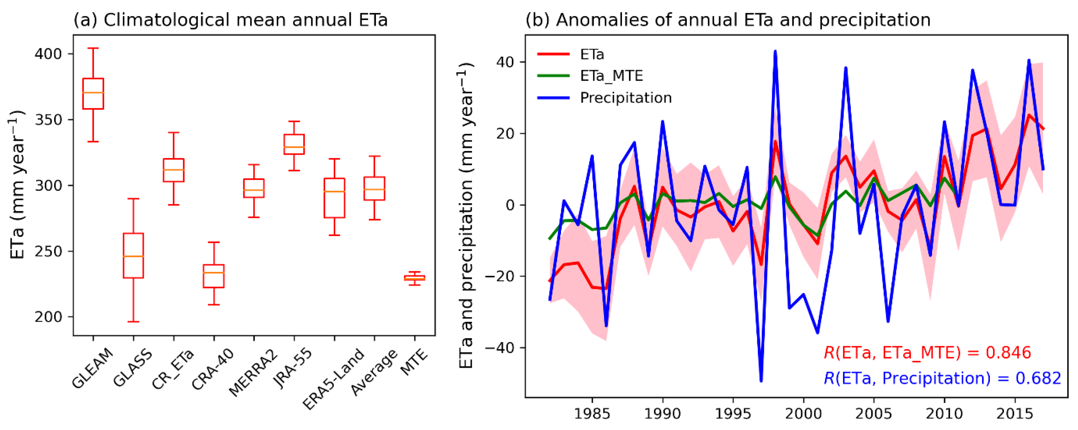
The regional mean ETa and statistical characteristics of various datasets are presented in Figure 3a. On average, GLEAM has the highest ETa (368.4 mm·year−1), and CR_ETa has the lowest ETa (233.4 mm·year−1). The average ETa of seven datasets is 297.1 mm·year−1, which is very close to precipitation (300.6 mm·year−1). The application of multiple datasets can effectively reduce the uncertainty of single data. According to the average of seven datasets, area-averaged ETa in northern China has a significant (p < 0.001) upward trend from 1982 to 2017 (Figure 3b), especially in the last decade. There is a significant positive correlation between precipitation and ETa (R = 0.682). However, although precipitation shows an increasing trend, it is insignificant (p = 0.151). As noted above, melting glaciers and snow in northwest China have increased runoff and have expanded lake areas in a warming climate [28]. This can provide an alternative source of water for ETa, and thus, can affect the relationship between ETa and precipitation [12].
As a reference, the mean (228.7 mm·year−1) and standard deviation of ETa for FLUXNET-MTE (ETa_MTE) are much lower than those of other datasets. This is probably because the average duration of data from EC sites used by ETa_MTE is only 2 years, and thus, has a low standard deviation [31,32]. Meanwhile, there are many missing values in FLUXNET-MTE, which have some impact on the area-averaged ETa_MTE. Since our study focuses on the temporal and spatial variation of ETa, the difference in the mean of ETa from different data is almost negligible. ETa_MTE also increases significantly (p < 0.005) and is significantly correlated with the average ETa of seven datasets (R = 0.846). It can be concluded that the temporal variation of ETa obtained from the seven datasets is reliable.
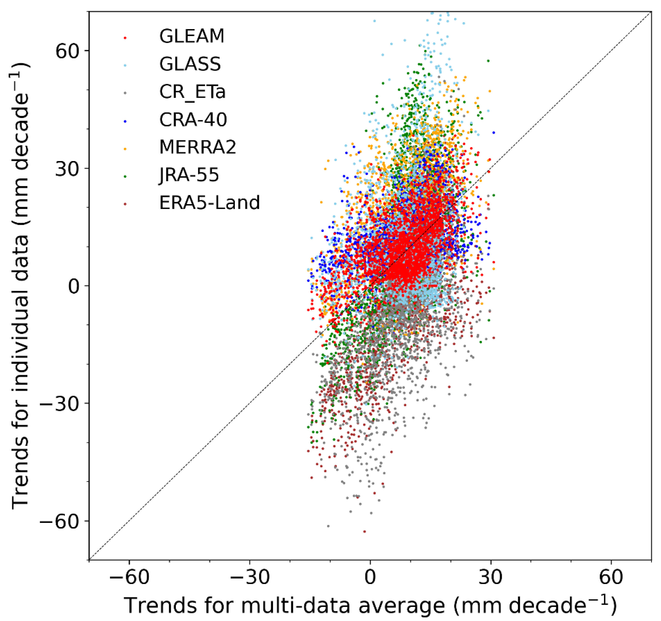
Given the uncertainties of various datasets, the consistency of their ETa trends is assessed. As shown in Figure 4, the discreteness of different ETa datasets is great. On average, long-term trends of ETa are generally higher for GLASS and CRA-40, and lower for ERA5-Land and CR_ETa (Figure 4). Compared with the average of seven datasets, the ETa trends for GLEAM are the closest. However, the lack of observations makes it difficult to accurately determine the reliability of each set of data [37]. Using a single dataset to study ETa changes is very prone to bias. By comparing the seven ETa datasets with each other, the dependence on a single data set is avoided and the results can be considered more robust.

3.2. Relationship between ETa and Precipitation

An analysis of the relationship between ETa and precipitation is helpful not only to clarify the causes of ETa changes [16], but also to evaluate the impact of global warming on regional water balance [30]. In this sub-section, SVD analysis is performed on ETa and precipitation in northern China. Table 2 provides selected statistics for the four leading modes of the SVD analysis [47]. The first four leading SVD modes account for 89.4% of the accumulated covariance, and the squared covariance is concentrated in the first mode. The correlation coefficients between the temporal coefficients of ETa (ak) and precipitation (bk) of the leading four modes are 0.86, 0.90, 0.73, and 0.89, respectively, representing the tight strength of the coupling in each mode.
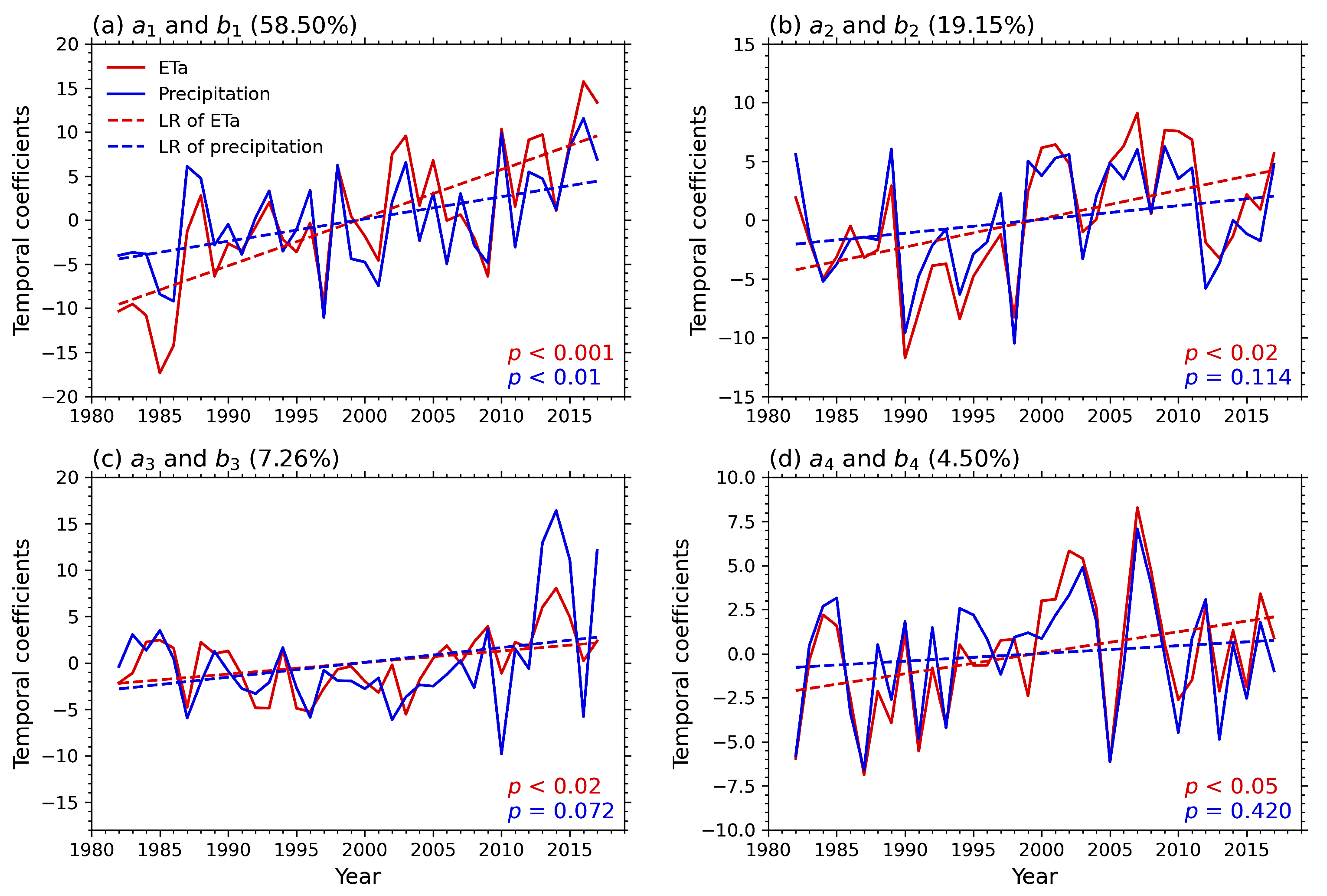
The corresponding temporal coefficients of ETa (ak) and precipitation (bk) are given in Figure 5. For the first SVD mode (Figure 5a), there is a high consistency between a1 and b1 in terms of interannual variation. For the long-term trend, both a1 and b1 have a significant positive trend, with a weaker trend for b1 (p < 0.01). a2 also has a significant positive trend (p < 0.001) (Figure 5b), while b2 shows no discernible trend (p = 0.114). The temporal variations of a3 and b3 are primarily on an interdecadal scale (Figure 5c). From 1982 to the beginning of the 20th century, a3 and b3 decrease slightly, but show an upward trend after that. Compared with a3, a4 still has a significant positive trend (p < 0.05), and its interannual variation is more pronounced. b4 agrees well with a4, except that b4 has an insignificant trend (p = 0.420).
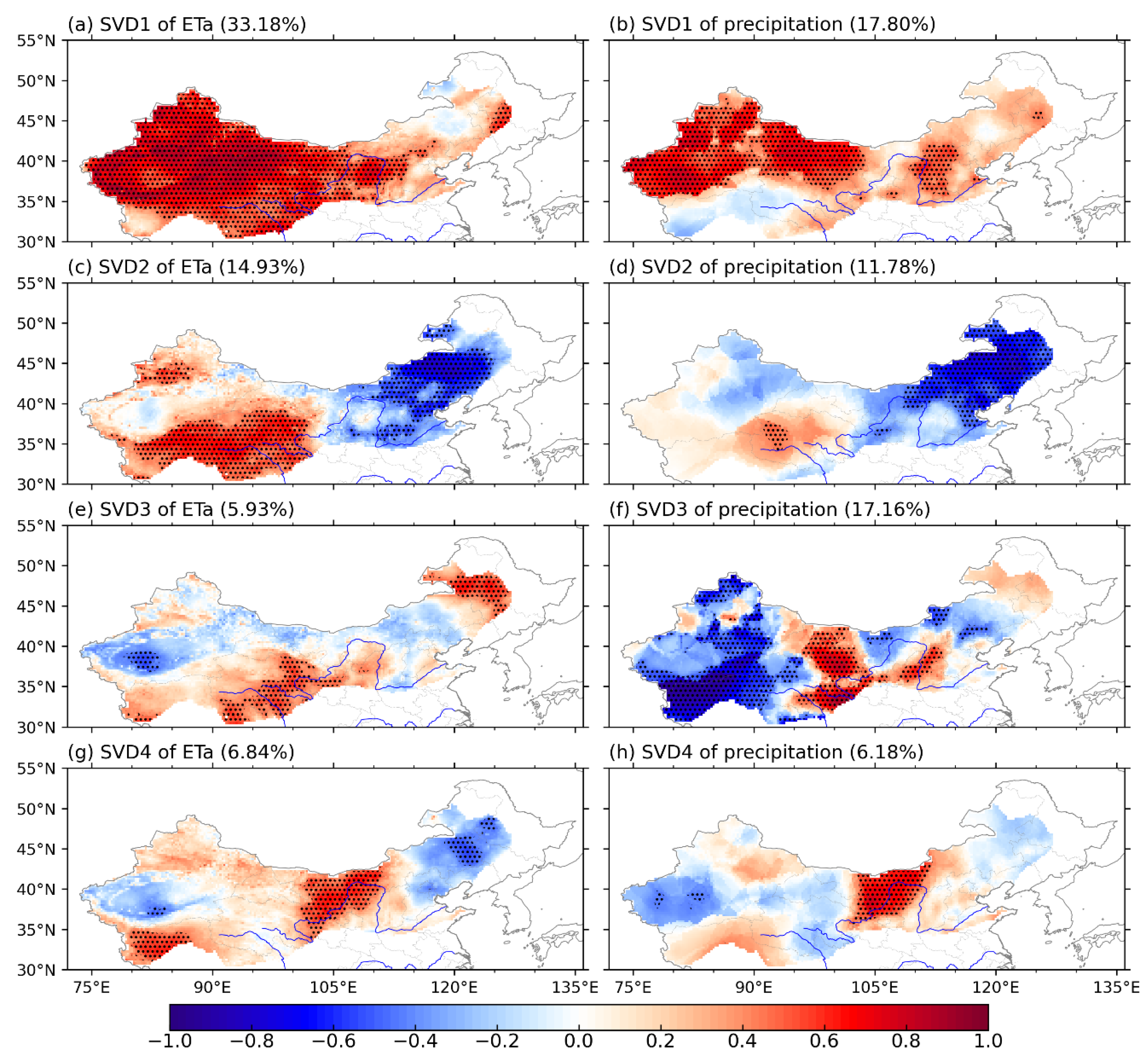
The homogeneous correlation pattern shows how the two fields are related to each other and how much variation is explained by the SVD mode [47]. According to the homogeneous correlation patterns (Figure 6) and the corresponding temporal coefficients (Figure 5), the linear trend of ETa (Figure 2e) is closely related to the first four leading SVD modes. Figure 6a shows the homogeneous correlation pattern for the leading SVD mode (SVD1) of ETa. Similar to the long-term trend (Figure 2e), ETa shows significant positive anomalies in most areas, especially in the central part of northwest China (Figure 6a). This pattern is accompanied by positive precipitation anomalies in the central and northern parts of northwest China and western parts of North China (Figure 6b). Except for the northern Tibetan Plateau, Loess Plateau and Inner Mongolia Plateau, the homogeneous correlation patterns of ETa and precipitation are generally consistent. It indicates that precipitation has a strong coupling effect with ETa, in which a positive relationship plays a dominant role; however, other coupling mechanisms are also involved.
The second homogeneous pattern (SVD2) of ETa exhibits negative anomalies in northeast and North China (Figure 6c), while positive anomalies are mainly concentrated in the Tibetan Plateau and the mountainous areas in northwest China, such as the Tianshan, Kunlun, and Qilian Mountains. In general, ETa anomalies agree reasonably well with precipitation anomalies in northeast and North China (Figure 6d), whereas there are pronounced differences in northwest China. The third SVD mode (SVD3) exhibits somewhat similar behavior to SVD2; ETa (Figure 6e) and precipitation (Figure 6f) are closely related in northeast China and North China, while the consistency is poor in northwest China. The obvious differences mainly occur in the northern Tibetan Plateau and the Badain Jaran Desert. The fourth SVD mode (SVD4) shows a good correspondence between ETa (Figure 6g) and precipitation (Figure 6h), with significant positive anomalies from the Loess Plateau to the Inner Mongolia Plateau. The large difference is still in northwest China.
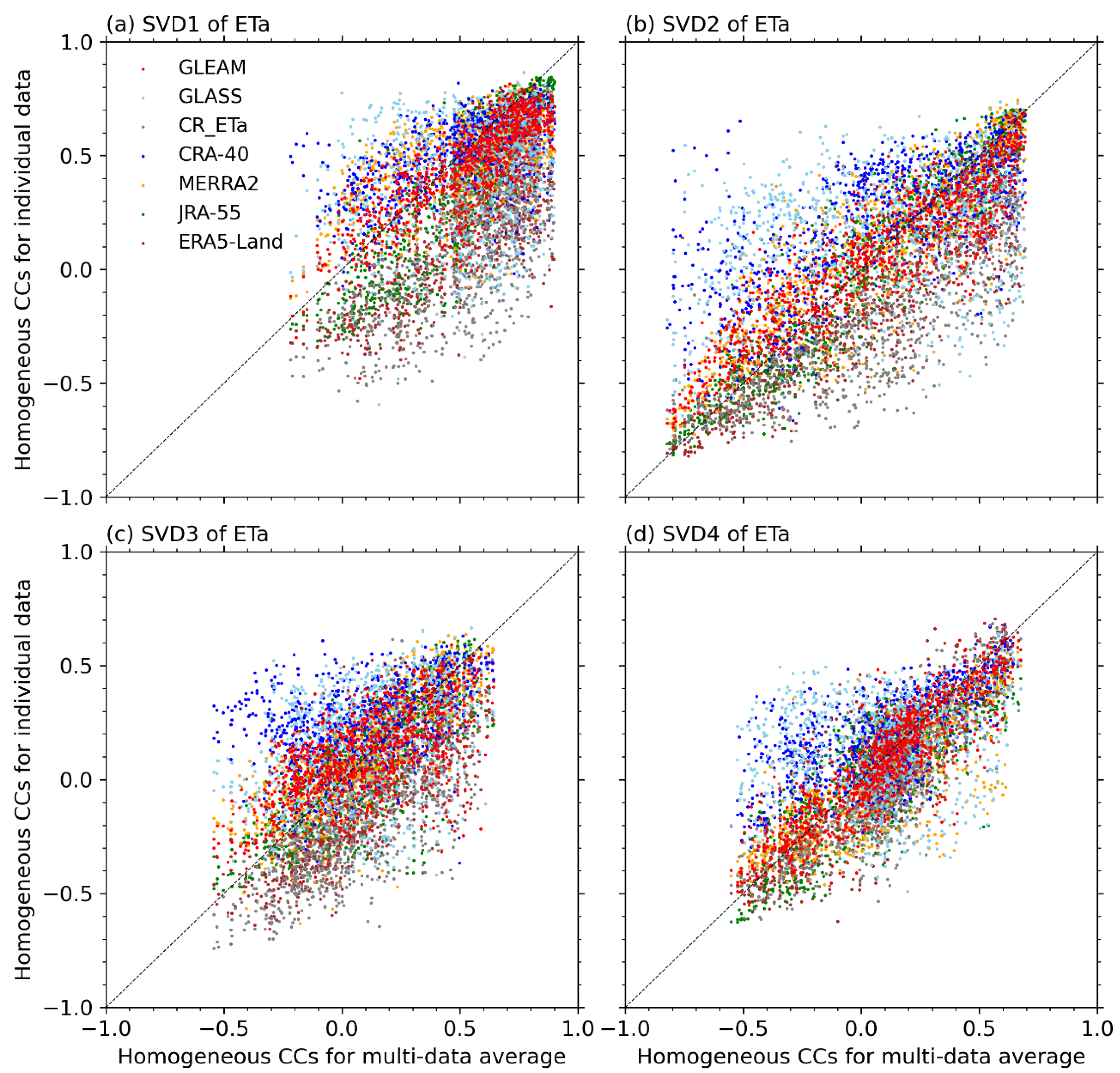
In order to quantify the uncertainties introduced by different datasets in SVD analysis, the homogeneous correlations for the seven ETa datasets are compared in Figure 7. For SVD1, most ETa datasets are generally consistent. In general, homogeneous correlations for CR_ETa and ERA5-Land are low, while those for CRA-40 and MERRAs are high. Similar findings are also found in SVD2 (Figure 7b) and SVD3 (Figure 7c). For SVD4 (Figure 7d), the homogeneous correlations of all ETa datasets are substantially in agreement with each other. The result above shows that ETa estimates from the seven datasets differ in some detail but are generally consistent. Thus, the relationships between ETa and precipitation for the first four leading SVD modes are strong and dependable. The coupled patterns provide insight into the feedback between ETa and precipitation. Furthermore, the integrated application of multiple sets of ETa datasets is an effective way to reduce uncertainty.
The results of SVD analysis show that the positive precipitation anomalies generally lead to high ETa. In particular, ETa is highly influenced by precipitation in northeast and North China. However, this relationship is not true in some parts of northwest China. Anomalies of ETa and precipitation correspond well in the northern part of northwest China, while it is inconsistent or even reversed in many other regions. The main differences can be found in the northern Tibetan Plateau and the Badain Jaran Desert. Many glaciers in northwest China are stable [28]. A glacier is a solid reservoir which can provide an abundance of water for rivers and can play an important role in regulating the distribution of ETa [12,28]. For the Badain Jaran Desert, the annual precipitation is less than 100 mm (Figure 2b). In principle, deserts are created by a lack of water, while in the extremely arid Badain Jaran Desert, sand mountains and lakes coexist, with more than 100 lakes [49]. At a regional scale, such a unique topography and climate may influence the relationship between ETa and precipitation. The specific reasons are further analyzed in the next section.
A comparison between ak and bk shows that there are big differences in their long-term trends. All the temporal coefficients of the first four leading SVD modes of ETa (ak) have a significant positive trend and are higher than those of precipitation (bk). ETa is basically determined by water supply and energy supply [12,21]. Precipitation is an important water source, while other water supplies such as runoff, terrestrial water storage, and glaciers also regulate the local water balance in northern China [12]. Meanwhile, in a warmer climate, rising atmospheric temperatures increase the atmosphere’s water-holding capacity, which means that more water is needed to saturate the atmosphere, prompting more surface water to convert to ETa [27]. All these imply that the feedback between ETa and precipitation is inevitably influenced by other factors.

3.3. Factors Regulating the Relationship between ETa and Precipitation

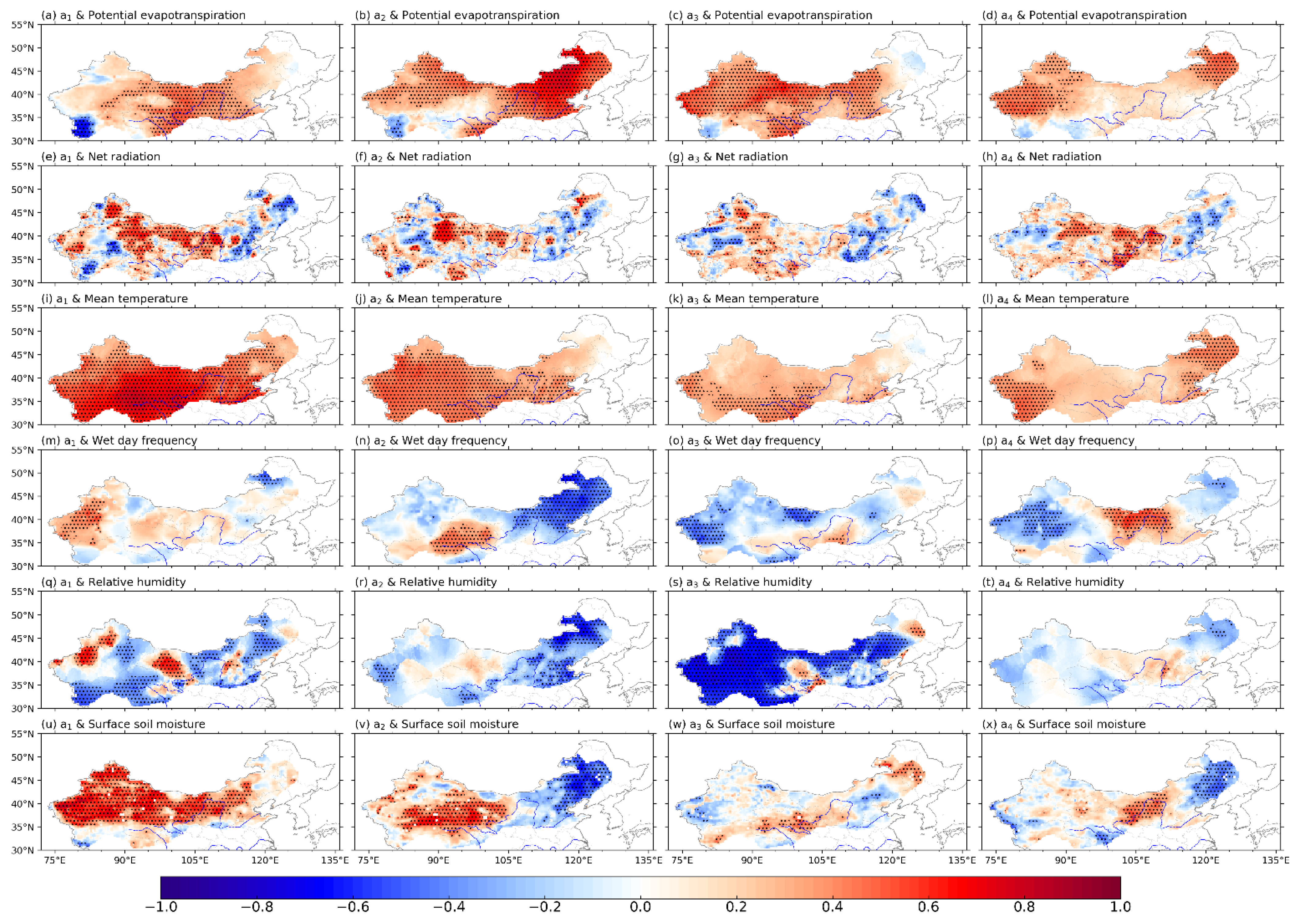
Pearson correlation analysis is applied to identify the key factors regulating the relationship between ETa and precipitation (Figure 8). As shown in Figure 8a, a1 is positively correlated with potential evapotranspiration in most areas of northern China. Potential evapotranspiration reflects the energy conditions that affect the conversion of precipitation into runoff and ETa. In theory, more potential evapotranspiration can prompt more surface water resources to be converted into ETa. This is probably the reason why the increasing trend of ETa is higher than that of precipitation (Figure 3b). Moreover, a1 has a positive correlation with temperature (Figure 8i). As mentioned above, many mountainous areas in northwest China are covered by glaciers (Figure 1). Positive temperature anomalies can force glaciers and snow to melt, creating runoff, and thus, altering the surrounding water balance. Such a process is evidenced by the distribution of surface soil moisture (Figure 8u). Meanwhile, a1 is positively correlated with wet-day frequency in many areas of northern China, and the high correlation is concentrated in the west part of northwest China. Most drylands have sparse vegetation and a weak water storage capacity, so heavy rainfall can easily lead to soil erosion [2,29]. Therefore, in addition to precipitation, the influence of wet-day frequency on ETa should not be ignored.
Except in the northern Tibetan Plateau, a2 is significantly positively correlated with potential evapotranspiration (Figure 8b). This indicates that potential evapotranspiration is also an important driver of SVD2 (Figure 6c). Meanwhile, a2 is significantly correlated to surface soil moisture in northwest China (Figure 8v), which has a corresponding relationship with precipitation (Figure 6d) and wet-day frequency (Figure 8n). Moreover, there are widespread positive temperature anomalies in northwest China (Figure 8j). Similar to SVD1, a surface soil moisture anomaly may partly come from glacial meltwater. Especially in the Kunlun Mountains, the positive precipitation anomaly (Figure 6d) is much weaker than that of surface soil moisture (Figure 8v). It can be concluded that water from precipitation and glacial meltwater jointly affect ETa by altering the local water distribution (Figure 8v). Therefore, under the combined influence of potential evapotranspiration and multi-source water supply, positive ETa anomalies exist in northwest China (Figure 6c).
SVD3 of ETa is greatly affected by potential evapotranspiration as well (Figure 8c). Positive potential evapotranspiration anomalies are generally accompanied by positive anomalies in temperature and net radiation, and negative anomalies in relative humidity and wet-day frequency, in which the contributions of temperature (Figure 8k) and relative humidity (Figure 8s) are relatively greater. This is not surprising because as temperatures rise, the amount of water that can be held in the air increases. That is, for the same amount of water vapor, the relative humidity decreases with air temperature rising, which leads to the simultaneous increase in atmospheric unsaturation and potential evapotranspiration [22]. In the eastern part of the Tibetan Plateau, a3 is significantly positively correlated with both potential evapotranspiration (Figure 8c) and surface soil moisture (Figure 8w). The positive ETa anomaly can be largely attributed to potential evapotranspiration and surface soil moisture.
For the fourth SVD mode, a4 correlates significantly with temperature in the western Kunlun Mountains (Figure 8l). This corresponds well to the regions with significant positive ETa anomalies (Figure 6g). Given the glacier/snow cover here, meltwater generated by a high temperature can provide water for ETa, which may be the main reason why the anomaly of ETa (Figure 6g) is higher than that of precipitation (Figure 6h) [12]. From the Loess Plateau to the Inner Mongolia Plateau, the positive anomalies of ETa correspond not only to precipitation (Figure 6h), but also to wet-day frequency (Figure 8p) and surface soil moisture (Figure 8x). Water supply is the determinant factor affecting ETa.
Vegetation is one of the most important indicators to measure the characteristics of the underlying surface [21,50]. As vegetation and ETa depend on water supply, ETa is usually high where there is much vegetation. Figure 9a clearly illustrates that a1 is positively correlated with NDVI in the eastern part of northern China and the mountainous areas of northwest China. This is in good agreement with the positive anomalies of ETa (Figure 6a). Similar results are also found in the other three SVD modes (Figure 9). In general, the precipitation trapped by the canopy is eventually consumed by ETa. Moreover, the regulation of vegetation on water resources is mainly determined by soil storage and permeability, and largely depends on soil pore structure and soil layer thickness [15]. The role of vegetation in soil and water conservation is mainly reflected in improving the soil infiltration capacity, improving soil runoff, and increasing soil storage capacity. The litter layer can trap a certain amount of precipitation, thus, reducing surface runoff [50]. The forest has a good ability to hold water, which can reduce flooding and increase base flow. Water stored in the soil provides a direct source of ETa. The eastern part of northern China has high vegetation coverage; thus, the positive correlation between ETa and NDVI is dominant. In most areas of western China, due to sparse vegetation, the relationship between ETa and NDVI is weak but still dominated by positive feedback.
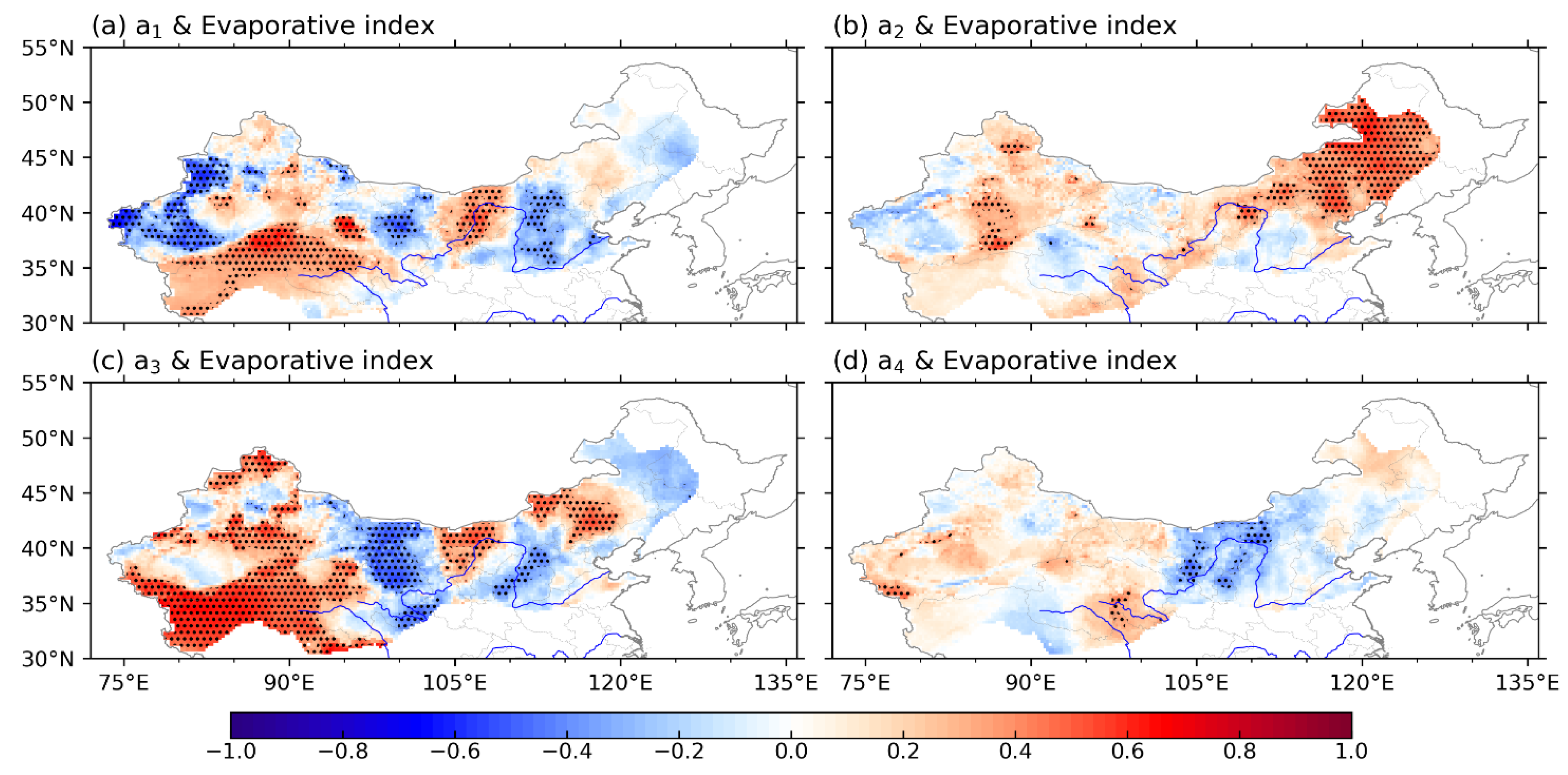
Terrestrial and atmospheric water cycles are closely linked through ETa and precipitation [27]. Figure 10 shows the Pearson correlation coefficients between ak and the evaporative index. A positive anomaly means that more precipitation is converted to ETa. In general, areas with negative precipitation anomalies have more precipitation converted to ETa. On a regional scale, this relationship also corresponds well to NDVI (Figure 9), as sparse vegetation in northern China results in a limited soil water storage capacity. When precipitation is low, more water is quickly returned to the atmosphere through ETa, while when precipitation is high, a large amount of water forms runoff, and a smaller proportion of water evaporates through local ETa. Where there is more precipitation, the more lush the vegetation is, and the less precipitation is converted into ETa.
The above analysis indicated that the relationship between ETa and precipitation is directly or indirectly modulated by other factors. The most important factors are potential evapotranspiration, temperature, and wet-day frequency. Potential evapotranspiration is one of the critical factors driving the variations of ETa. Both theory and facts show that higher potential evapotranspiration under global warming could convert more surface water into ETa [22], resulting in a substantial increase in ETa (Figure 2e). Meanwhile, the surface soil moisture anomalies in the northern Tibetan Plateau, such as the Kunlun Mountains, are very likely related to the glacier/snow melt water formed by the temperature rising [28]. Meltwater can provide water for ETa and make up for the lack of precipitation to a certain extent [12]. In addition, ETa is also affected by the frequency of precipitation. ETa tends to be higher in areas with higher wet-day frequency. Soil moisture recharge in arid areas is largely dependent on precipitation. An increase in wet-day frequency leads to more ETa, even when the total amount of precipitation does not change. The effect of wet-day frequency on ETa is even greater than that of precipitation in some regions, such as the Badain Jaran Desert. This is consistent with Ma et al. [49], who found that it takes 1 to 3 days and 3 to 4 weeks for water with rainfall of less than 5 mm and 20 mm, respectively, to evaporate from the surface, and longer after rainfall of more than 40 mm in the Badain Jaran Desert.

4. Discussion

4.1. Uncertainty of ETa Data

Knowledge of the water cycle has improved substantially in recent decades due to adopting efficient global data assimilation and analysis systems in various reanalyses. Most current reanalyses share common data sources, whereas the datasets are often processed and combined differently. Furthermore, ETa in reanalysis has never been measured, and instead is generally estimated from bulk flux formulas [20]. The uncertainty of ETa estimates comes from random and systematic errors in the retrieval of variables such as sampling, instrument noise, and satellite coverage, as well as errors introduced by the bulk formula itself [43]. As a result, despite the general similarity, striking discrepancies exist. Other datasets, such as GLEAM, use reanalyses for their derivation [39], and hence, are subject to these uncertainties.
To demonstrate the validity of different ETa data, it is not enough to consider only one aspect, such as the long-term trend. Other features also need to be considered, which are crucial to confirm the applicability of ETa data. The lack of reliable ETa data remains a constraint in addressing this issue. Many previous studies have used eddy-covariance observations to assess the reliability of different ETa data [8,9]. We also verified the variation characteristics of ETa by comparing seven datasets with FLUXNET-MTE. However, due to insufficient observational data, it is difficult to measure the accuracy of each dataset comprehensively, especially at the regional scale. Even though the ETa estimates from the seven datasets have many consistent characteristics, their inconsistency cannot be ignored. In theory, the statistical average reflects the central tendency of data distribution. The average of different data is one of the most direct and effective methods to reduce data uncertainty.
The variation of ETa involves many local microscopic land-surface processes at the regional scale [50]. For example, an oasis is an ecosystem with a stable water supply and is conducive to biological survival and human aggregation in arid desert areas. Oases account for only 3%–5% of the total area of arid areas in northwest China, but support more than 90% of the population. Water is a necessary condition for the formation of oases. Flat terrain, fertile land, and good vegetation cover are the basis for the formation of most oases. These also provide suitable conditions for ETa [29]. It can be concluded that oases play an essential role in the change of ETa in northern China. However, the horizontal resolutions of many ETa data are too coarse to characterize the processes involved. Similarly, North China, which has only 4% of the country’s water resources, uses about 70% for agricultural irrigation. Agriculture is directly affected by human activities [22]. Many human activities, such as irrigation, have a very evident impact on ETa on a local scale. In addition, due to the implementation of the South-to-North water transfer in China, irrigation may have used water transfers from other regions. The effect of this on ETa is also not negligible. Further studies are needed to reveal these mechanisms in detail.

4.2. Impact of Human Activities on ETa

ETa is a complex process influenced by climate and geography [50,51], both of which are strongly influenced by human activities [52]. The changing climate and the continuous human activities jointly determine the changes in ETa. Overall, ETa in drylands is primarily limited by water supply. Human activities, such as the construction of reservoirs, have greatly affected the allocation of water resources [51]. Similarly, the river discharge has been artificially controlled by dams in most parts of China. The construction of reservoirs and dams can increase the local water supply, which is crucial for ETa. Moreover, China is a country with a distinct monsoon climate, hence, precipitation has strong seasonal variations. Heavy and torrential precipitation events often occur in the rainy season, accounting for about 70% of the annual precipitation. Reservoirs can hold water during the rainy season and release water during the dry season to replenish rivers and alleviate drought [12]. Such processes greatly help the rational utilization of water resources and are conducive to converting more precipitation into ETa. In recent decades, the construction of the water conservancy project is developing rapidly in China [53], which is quite consistent with the significant increase in ETa. Thus, this is another possible reason why the increase in ETa is higher than that of precipitation (Figure 2).
Soil is also an important reservoir of water. The relationship between ETa and precipitation is evidently affected by the soil water storage capacity [15]. For example, forest soil can store precipitation for a certain period and penetrate the soil along the coarse pores in the soil, thereby affecting ETa. Human activities, such as land-use change, farmland irrigation, agricultural and forestry reclamation, deforestation, and the expansion of impervious layer areas due to urbanization, can directly affect the underlying surface. The effects of human activities, while localized, are often very intense and sometimes extend over large areas of the water cycle. Nevertheless, quantifying the impact of these human activities on ETa remains challenging. The related processes and mechanisms need further investigation.

4.3. Impact of Precipitation Intensity on ETa

Under global warming, a significant adjustment in precipitation intensity has taken place. In recent years, extreme precipitation events have occurred frequently in northern China, such as the Beijing rainstorm event on 21 July 2012, which directly impacted local and surrounding water resources. Heavy precipitation events often induce oversaturated soil moisture, and more precipitation is transported to other areas by runoff [15], resulting in inconsistent trends and magnitudes of ETa and precipitation. Therefore, from the perspective of spatial distribution, the increase in precipitation is more concentrated, while the increase in ETa is more scattered (Figure 2).
It is a fact that northwest China is getting warmer and wetter, and the precipitation in North China is increasing (Figure 2f). Numerous studies suggest that the increase in total precipitation was mainly caused by the increase in extreme precipitation. For example, in addition to the total precipitation (Figure 2f), the intensity and frequency of extreme precipitation in northern Xinjiang has increased significantly. Precipitation is a rapidly changing variable with a limited duration, whereas ETa is a slowly changing variable with continuous water consumption. Global warming aggravates the instability of the climate system and the global water cycle, which increases the instability of the atmosphere, improves the precipitation efficiency, and makes heavy precipitation more significant. As a result, extreme weather and climate events are more sensitive to global warming than an average climate. According to the trend of extreme weather events in China in recent years, the precipitation intensity is increasing. The effect of precipitation intensity on ETa is expected to increase substantially.

5. Conclusions

With the intensification of human activities and global warming, the contradiction between the supply and demand of water resources is severe in northern China. ETa and precipitation together determine the surface water balance. Analysis of ETa changes is of great significance for water resources assessments. In this study, seven datasets (GLEAM, GLASS, CR_ETa, CRA-40, MERRA2, JRA-55 and ERA5-Land) were employed to analyze ETa variability in northern China (AI < 0.65). The average of the seven datasets shows that area-averaged ETa in northern China increases significantly (p < 0.001) from 1982 to 2017. Spatially, ETa in northwest China has a significant increasing trend (p < 0.05), whereas ETa in northeast China and some parts of North China shows a significant decreasing trend (p < 0.05). A tremendous increase in ETa is observed in the Tianshan, Kunlun, and Qilian Mountains. Despite some differences, all datasets show a roughly similar behavior.
ETa in drylands strongly depend on water supply. Annual ETa in northern China is significantly correlated with precipitation (R = 0.682). However, it should be noted that although precipitation has an increasing trend, it is insignificant (p = 0.151). Therefore, singular value decomposition (SVD) was used to analyze the relationship between ETa and precipitation. The linear trend of ETa is strongly related to the first four leading SVD modes (accounting for 89.4% of the accumulated covariance) according to the temporal coefficients and the homogeneous correlation patterns. The temporal coefficients of the first four leading SVD modes of ETa show a significant positive trend, which is higher than that of precipitation. The positive precipitation anomalies generally increase ETa in most areas. However, in some regions, notably the Kunlun Mountains and the Badain Jaran Desert, this relationship does not hold.
Positive potential evapotranspiration anomalies (mainly due to high temperature and low relative humidity) can convert more surface water resources into ETa. This may be the main reason why the increase in ETa is higher than that of precipitation. In terms of spatial distribution, positive temperature anomalies can force glaciers and snow to melt, creating runoff, and thus, altering the surrounding water balance and ETa. Such a process is confirmed in the distribution of surface soil water in the Kunlun Mountains. For the Badain Jaran Desert, the relationship between ETa and precipitation is weak due to the influence of wet-day frequency. Overall, precipitation is closely related to ETa in the eastern part of northern China, where vegetation coverage is high, while their relationship is weak in most parts of western China due to sparse vegetation.
Drought is the most serious natural disaster to cause an economic loss in the world [13]. The role of precipitation in characterizing drought and aridification has been recognized in northern China. Precipitation is an important factor, but not the only one, that acts on the dry/wet changes of surfaces [24]—ETa also plays a crucial role in water balance. The emergence of different ETa data provides a new way to solve the related problems of ETa. In this study, seven sets of data were used to analyze the variation of ETa. To estimate the uncertainty contained in these datasets, differences in ETa in the spatial variability, temporal variation, and long-term changes were compared. Such comparisons can help us better evaluate the uncertainty of different data in the analysis of ETa change.

Author Contributions

Conceptualization, T.S. and S.S.; methodology, B.H.; software, S.W. and D.X.; validation, T.S. and B.H.; formal analysis, S.L.; investigation, S.S.; resources, T.S.; data curation, S.S.; writing—original draft preparation, T.S.; writing—review and editing, S.L. and Q.M.; visualization, Z.Q.; supervision, T.F.; project administration, G.F.; funding acquisition, T.S. All authors have read and agreed to the published version of the manuscript.

Funding

This research was funded by the National Natural Science Foundation of China (Grant Nos. 42175071, 41905060, 41975062, 42075051, 42130610, and 41705053) and the National Key Research and Development Program of China (2017YFC1502303).

Data Availability Statement

The gridded observation data are obtained from the China Meteorological Administration and the Climate Research Unit (https://crudata.uea.ac.uk/cru/data/hrg/; accessed on 18 May 2022). Actual evapotranspiration datasets are obtained from the Global Land Evaporation Amsterdam Model (https://www.gleam.eu/; accessed on 1 June 2021), the Global Land Surface Satellite (http://www.glass.umd.edu/; accessed on 5 May 2022), the complementary relationship-based dataset (https://data.tpdc.ac.cn/zh-hans/; accessed on 15 September 2021), the European Centre for Medium-Range Weather Forecasts (https://cds.climate.copernicus.eu/cdsapp#!/home; accessed on 25 September 2021), the Japan Meteorological Agency (https://jra.kishou.go.jp/index.html; accessed on 20 September 2021), the Global Modeling and Assimilation Office (https://gmao.gsfc.nasa.gov/reanalysis/MERRA-2/; accessed on 20 September 2021), and the China Meteorological Data Service Centre (http://data.cma.cn/data/index/98555d0119fa185a.html; accessed on 20 May 2022).

Acknowledgments

We are grateful to the public data portal for providing the datasets used in this study at no cost.

Conflicts of Interest

The authors declare no conflict of interest.

References

  1. An, L.; Wang, J.; Huang, J.; Pokhrel, Y.; Hugonnet, R.; Wada, Y.; Cáceres, D.; Müller Schmied, H.; Song, C.; Berthier, E.; et al. Divergent Causes of Terrestrial Water Storage Decline Between Drylands and Humid Regions Globally. Geophys. Res. Lett. 2021, 48, e2021GL095035. [Google Scholar] [CrossRef]
  2. Feng, S.; Fu, Q. Expansion of global drylands under a warming climate. Atmos. Chem. Phys. 2013, 13, 10081–10094. [Google Scholar] [CrossRef]
  3. Lian, X.; Piao, S.; Chen, A.; Huntingford, C.; Fu, B.; Li, L.Z.X.; Huang, J.; Sheffield, J.; Berg, A.M.; Keenan, T.F.; et al. Multifaceted characteristics of dryland aridity changes in a warming world. Nat. Rev. Earth Environ. 2021, 2, 232–250. [Google Scholar] [CrossRef]
  4. Feng, T.; Su, T.; Ji, F.; Zhi, R.; Han, Z. Temporal Characteristics of Actual Evapotranspiration Over China under Global Warming. J. Geophys. Res. Atmos. 2018, 123, 5845–5858. [Google Scholar] [CrossRef]
  5. Li, X.; Gemmer, M.; Zhai, J.; Liu, X.; Su, B.; Wang, Y. Spatio-temporal variation of actual evapotranspiration in the Haihe River Basin of the past 50 years. Quat. Int. 2013, 304, 133–141. [Google Scholar] [CrossRef]
  6. Liu, Q.; Yang, Z. Quantitative estimation of the impact of climate change on actual evapotranspiration in the Yellow River Basin, China. J. Hydrol. 2010, 395, 226–234. [Google Scholar] [CrossRef]
  7. Matin, M.A.; Bourque, C.P.A. Assessing spatiotemporal variation in actual evapotranspiration for semi-arid watersheds in northwest China: Evaluation of two complementary-based methods. J. Hydrol. 2013, 486, 455–465. [Google Scholar] [CrossRef]
  8. Ma, N.; Szilagyi, J.; Zhang, Y. Calibration-Free Complementary Relationship Estimates Terrestrial Evapotranspiration Globally. Water Resour. Res. 2021, 57, e2021WR029691. [Google Scholar] [CrossRef]
  9. Ma, N.; Szilagyi, J.; Zhang, Y.; Liu, W. Complementary-Relationship-Based Modeling of Terrestrial Evapotranspiration Across China During 1982-2012: Validations and Spatiotemporal Analyses. J. Geophys. Res. Atmos. 2019, 124, 4326–4351. [Google Scholar] [CrossRef]
  10. Yang, Z.; Zhang, Q.; Yang, Y.; Hao, X.; Zhang, H. Evaluation of evapotranspiration models over semi-arid and semi-humid areas of China. Hydrol. Process. 2016, 30, 4292–4313. [Google Scholar] [CrossRef]
  11. Yang, Z.; Zhang, Q.; Hao, X. Environmental and biological controls on monthly and annual evapotranspiration in China’s Loess Plateau. Theor. Appl. Climatol. 2018, 137, 1675–1692. [Google Scholar] [CrossRef]
  12. Su, T.; Xie, D.; Feng, T.; Huang, B.; Qian, Z.; Feng, G.; Wu, Y. Quantifying the contribution of terrestrial water storage to actual evapotranspiration trends by the extended Budyko model in Northwest China. Atmos. Res. 2022, 273, 106147. [Google Scholar] [CrossRef]
  13. Huang, J.; Ji, M.; Xie, Y.; Wang, S.; He, Y.; Ran, J. Global semi-arid climate change over last 60 years. Clim. Dyn. 2015, 46, 1131–1150. [Google Scholar] [CrossRef]
  14. Huo, Z.; Dai, X.; Feng, S.; Kang, S.; Huang, G. Effect of climate change on reference evapotranspiration and aridity index in arid region of China. J. Hydrol. 2013, 492, 24–34. [Google Scholar] [CrossRef]
  15. Wang, K.; Dickinson, R.E. A review of global terrestrial evapotranspiration: Observation, modeling, climatology, and climatic variability. Rev. Geophys. 2012, 50, 54. [Google Scholar] [CrossRef]
  16. Zhang, Q.; Yang, Z.; Hao, X.; Yue, P. Conversion features of evapotranspiration responding to climate warming in transitional climate regions in northern China. Clim. Dyn. 2018, 52, 3891–3903. [Google Scholar] [CrossRef]
  17. Shen, Y.; Liu, C.; Liu, M.; Zeng, Y.; Tian, C. Change in pan evaporation over the past 50 years in the arid region of China. Hydrol. Process. 2009, 24, 225–231. [Google Scholar] [CrossRef]
  18. Wang, W.; Shao, Q.; Peng, S.; Xing, W.; Yang, T.; Luo, Y.; Yong, B.; Xu, J. Reference evapotranspiration change and the causes across the Yellow River Basin during 1957-2008 and their spatial and seasonal differences. Water Resour. Res. 2012, 48, W05530. [Google Scholar] [CrossRef]
  19. Zuo, H.; Chen, B.; Wang, S.; Guo, Y.; Zuo, B.; Wu, L.; Gao, X. Observational study on complementary relationship between pan evaporation and actual evapotranspiration and its variation with pan type. Agric. For. Meteorol. 2016, 222, 1–9. [Google Scholar] [CrossRef]
  20. Su, T.; Feng, T.; Feng, G. Evaporation variability under climate warming in five reanalyses and its association with pan evaporation over China. J. Geophys. Res. Atmos. 2015, 120, 8080–8098. [Google Scholar] [CrossRef]
  21. Wang, Y.; Luo, Y.; Shafeeque, M.; Zhou, M.; Li, H. Modelling interannual variations in catchment evapotranspiration considering vegetation and climate seasonality using the Budyko framework. Hydrol. Process. 2021, 35, e14118. [Google Scholar] [CrossRef]
  22. Douville, H.; Ribes, A.; Decharme, B.; Alkama, R.; Sheffield, J. Anthropogenic influence on multidecadal changes in reconstructed global evapotranspiration. Nat. Clim. Chang. 2013, 3, 59–62. [Google Scholar] [CrossRef]
  23. Immerzeel, W.W.; Bierkens, M.F.P. Asia’s water balance. Nat. Geosci. 2012, 5, 841–842. [Google Scholar] [CrossRef]
  24. Greve, P.; Orlowsky, B.; Mueller, B.; Sheffield, J.; Reichstein, M.; Seneviratne, S.I. Global assessment of trends in wetting and drying over land. Nat. Geosci. 2014, 7, 716–721. [Google Scholar] [CrossRef]
  25. Wang, L.; Yuan, X.; Xie, Z.; Wu, P.; Li, Y. Increasing flash droughts over China during the recent global warming hiatus. Sci. Rep. 2016, 6, 30571. [Google Scholar] [CrossRef]
  26. Wu, C.; Hu, B.X.; Huang, G.; Zhang, H. Effects of climate and terrestrial storage on temporal variability of actual evapotranspiration. J. Hydrol. 2017, 549, 388–403. [Google Scholar] [CrossRef]
  27. Lu, C.; Huang, G.; Wang, G.; Zhang, J.; Wang, X.; Song, T. Long-Term Projection of Water Cycle Changes over China Using RegCM. Remote Sens. 2021, 13, 3832. [Google Scholar] [CrossRef]
  28. Yao, J.; Chen, Y.; Guan, X.; Zhao, Y.; Chen, J.; Mao, W. Recent climate and hydrological changes in a mountain–basin system in Xinjiang, China. Earth-Sci. Rev. 2022, 226, 103957. [Google Scholar] [CrossRef]
  29. Yang, L.; Feng, Q.; Adamowski, J.F.; Alizadeh, M.R.; Yin, Z.; Wen, X.; Zhu, M. The role of climate change and vegetation greening on the variation of terrestrial evapotranspiration in northwest China’s Qilian Mountains. Sci. Total Environ. 2021, 759, 143532. [Google Scholar] [CrossRef]
  30. Zhang, Q.; Wang, S.; Yue, P.; Wang, S. Variation characteristics of non-rainfall water and its contribution to crop water requirements in China’s summer monsoon transition zone. J. Hydrol. 2019, 578, 124039. [Google Scholar] [CrossRef]
  31. Jung, M.; Reichstein, M.; Margolis, H.A.; Cescatti, A.; Richardson, A.D.; Arain, M.A.; Arneth, A.; Bernhofer, C.; Bonal, D.; Chen, J.; et al. Global patterns of land-atmosphere fluxes of carbon dioxide, latent heat, and sensible heat derived from eddy covariance, satellite, and meteorological observations. J. Geophys. Res. 2011, 116, G00J07. [Google Scholar] [CrossRef]
  32. Liu, W.; Wang, L.; Zhou, J.; Li, Y.; Sun, F.; Fu, G.; Li, X.; Sang, Y.-F. A worldwide evaluation of basin-scale evapotranspiration estimates against the water balance method. J. Hydrol. 2016, 538, 82–95. [Google Scholar] [CrossRef]
  33. Bhattarai, N.; Wagle, P. Recent Advances in Remote Sensing of Evapotranspiration. Remote Sens. 2021, 13, 4260. [Google Scholar] [CrossRef]
  34. Wang, G.; Pan, J.; Shen, C.; Li, S.; Lu, J.; Lou, D.; Hagan, D. Evaluation of Evapotranspiration Estimates in the Yellow River Basin against the Water Balance Method. Water 2018, 10, 1884. [Google Scholar] [CrossRef]
  35. Wang, Y.; Liu, B.; Su, B.; Zhai, J.; Gemmer, M. Trends of Calculated and Simulated Actual Evaporation in the Yangtze River Basin. J. Clim. 2011, 24, 4494–4507. [Google Scholar] [CrossRef]
  36. Li, X.; He, Y.; Zeng, Z.; Lian, X.; Wang, X.; Du, M.; Jia, G.; Li, Y.; Ma, Y.; Tang, Y.; et al. Spatiotemporal pattern of terrestrial evapotranspiration in China during the past thirty years. Agric. For. Meteorol. 2018, 259, 131–140. [Google Scholar] [CrossRef]
  37. Ochege, F.U.; Shi, H.; Li, C.; Ma, X.; Igboeli, E.E.; Luo, G. Assessing Satellite, Land Surface Model and Reanalysis Evapotranspiration Products in the Absence of In-Situ in Central Asia. Remote Sens. 2021, 13, 5148. [Google Scholar] [CrossRef]
  38. Liang, S.; Cheng, J.; Jia, K.; Jiang, B.; Zhou, J. The global land surface satellite (glass) product suite. Bull. Am. Meteorol. Soc. 2021, 102, E323–E337. [Google Scholar] [CrossRef]
  39. Martens, B.; Gonzalez Miralles, D.; Lievens, H.; Van Der Schalie, R.; De Jeu, R.A.; Fernández-Prieto, D.; Beck, H.E.; Dorigo, W.; Verhoest, N. GLEAM v3: Satellite-based land evaporation and root-zone soil moisture. Geosci. Model Dev. 2017, 10, 1903–1925. [Google Scholar] [CrossRef]
  40. Zhao, D.; Zhang, L.; Zhou, T.; Liu, J. Contributions of Local and Remote Atmospheric Moisture Fluxes to East China Precipitation Estimated from CRA-40 Reanalysis. J. Meteorol. Res. 2021, 35, 32–45. [Google Scholar] [CrossRef]
  41. Gelaro, R.; McCarty, W.; Suarez, M.J.; Todling, R.; Molod, A.; Takacs, L.; Randles, C.; Darmenov, A.; Bosilovich, M.G.; Reichle, R.; et al. The Modern-Era Retrospective Analysis for Research and Applications, Version 2 (MERRA-2). J. Clim. 2017, 30, 5419–5454. [Google Scholar] [CrossRef] [PubMed]
  42. Kobayashi, S.; Ota, Y.; Harada, Y.; Ebita, A.; Moriya, M.; Onoda, H.; Onogi, K.; Kamahori, H.; Kobayashi, C.; Endo, H.; et al. The JRA-55 Reanalysis: General Specifications and Basic Characteristics. J. Meteorol. Soc. Jpn. Ser. II 2015, 93, 5–48. [Google Scholar] [CrossRef]
  43. Muñoz-Sabater, J.; Dutra, E.; Agustí-Panareda, A.; Albergel, C.; Arduini, G.; Balsamo, G.; Boussetta, S.; Choulga, M.; Harrigan, S.; Hersbach, H.; et al. ERA5-Land: A state-of-the-art global reanalysis dataset for land applications. Earth Syst. Sci. Data 2021, 13, 4349–4383. [Google Scholar] [CrossRef]
  44. Wu, J.; Gao, X.; Giorgi, F.; Chen, D. Changes of effective temperature and cold/hot days in late decades over China based on a high resolution gridded observation dataset. Int. J. Climatol. 2017, 37, 788–800. [Google Scholar] [CrossRef]
  45. Harris, I.; Osborn, T.J.; Jones, P.; Lister, D. Version 4 of the CRU TS monthly high-resolution gridded multivariate climate dataset. Sci. Data 2020, 7, 109. [Google Scholar] [CrossRef]
  46. Pinzon, J.; Tucker, C. A Non-Stationary 1981–2012 AVHRR NDVI3g Time Series. Remote Sens. 2014, 6, 6929–6960. [Google Scholar] [CrossRef]
  47. Weare, B.C. Composite Singular Value Decomposition Analysis of Moisture Variations Associated with the Madden-Julian Oscillation. J. Clim. 2003, 16, 3779–3792. [Google Scholar] [CrossRef]
  48. Chen, J.; Tan, H.; Ji, Y.; Tang, Q.; Yan, L.; Chen, Q.; Tan, D. Evapotranspiration Components Dynamic of Highland Barley Using PML ET Product in Tibet. Remote Sensing 2021, 13. [Google Scholar] [CrossRef]
  49. Ma, N.; Wang, N.; Zhao, L.; Zhang, Z.; Dong, C.; Shen, S. Observation of mega-dune evaporation after various rain events in the hinterland of Badain Jaran Desert, China. Chin. Sci. Bull. 2014, 59, 162–170. [Google Scholar] [CrossRef]
  50. Berg, A.; Findell, K.; Lintner, B.; Giannini, A.; Seneviratne, S.I.; van den Hurk, B.; Lorenz, R.; Pitman, A.; Hagemann, S.; Meier, A.; et al. Land–atmosphere feedbacks amplify aridity increase over land under global warming. Nat. Clim. Chang. 2016, 6, 869–874. [Google Scholar] [CrossRef]
  51. Ren, Y.; Yu, H.; Liu, C.; He, Y.; Huang, J.; Zhang, L.; Hu, H.; Zhang, Q.; Chen, S.; Liu, X.; et al. Attribution of Dry and Wet Climatic Changes over Central Asia. J. Clim. 2022, 35, 1399–1421. [Google Scholar] [CrossRef]
  52. Liu, Y.; Tian, J.; Liu, R.; Ding, L. Influences of Climate Change and Human Activities on NDVI Changes in China. Remote Sens. 2021, 13, 4326. [Google Scholar] [CrossRef]
  53. Mao, Y.; Wang, K.; Liu, X.; Liu, C. Water storage in reservoirs built from 1997 to 2014 significantly altered the calculated evapotranspiration trends over China. J. Geophys. Res. Atmos. 2016, 121, 10097–10112. [Google Scholar] [CrossRef]
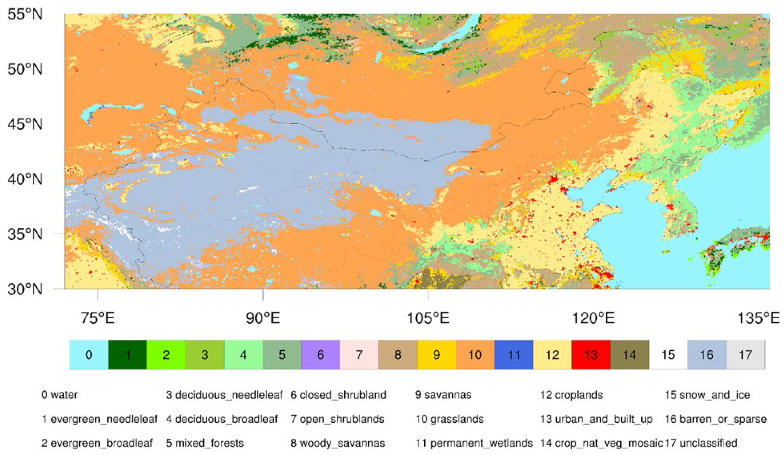
Figure 1. Land cover map of northern China in 2013 derived from the MODIS land cover (MCD12C1 v006) data.
Remotesensing 14 04554 g001
Figure 2. Long-term mean annual (a) ETa, (b) precipitation (unit: mm·year−1), (c) aridity index (AI), and (d) evaporative index in northern China (AI < 0.65). (e,f) show the linear trends of ETa and precipitation during 1982–2017 (unit: mm·decade−1), respectively. The dots in (e,f) denote values exceeding the 95% confidence level.
Remotesensing 14 04554 g002
Figure 3. (a) Boxplots of the area-averaged annual ETa for GLEAM, GLASS, CR_ETa, MERRA2, ERA5-Land, CRA-40, JRA-55, the average of seven datasets (Average), and FLUXNET-MTE (MTE) in northern China; (b) annual anomaly time-series of area-averaged ETa and precipitation (unit: mm·year−1) in northern China during 1982–2017. The magenta shading indicates one standard deviation up and down among different ETa datasets. R denotes Pearson correlation coefficient between ETa, ETa_MTE, and precipitation.
Remotesensing 14 04554 g003
Figure 4. Trends in ETa obtained from GLEAM, GLASS, CR_ETa, CRA-40, MERRA2, JRA-55, and ERA5-Land as a function of trends in ETa for the ensemble average of seven datasets in northern China from 1982 to 2017 (unit: mm·decade−1).
Remotesensing 14 04554 g004
Figure 5. The corresponding temporal coefficients of ETa (ak, red line) and precipitation (bk, blue line) for the four leading modes of SVD analysis during 1982–2017. The dotted lines represent the linear regression of the times series.
Remotesensing 14 04554 g005
Figure 6. Homogeneous correlation patterns for the first four leading SVD modes of ETa and precipitation in northern China during 1982–2017. The dots denote values exceeding the 95% confidence level.
Remotesensing 14 04554 g006
Figure 7. The same as Figure 4 but for the homogeneous correlations (homogeneous CCs) of the first four leading SVD modes of ETa: (a) SVD1, (b) SVD2, (c) SVD3, and (d) SVD4.
Remotesensing 14 04554 g007
Figure 8. Pearson correlation coefficients at each grid point between the corresponding temporal coefficients of ETa for the four leading modes of the SVD analysis and (ad) potential evapotranspiration, (eh) net radiation, (il) mean temperature, (mp) wet-day frequency, (qt) relative humidity, and (ux) surface soil moisture in northern China during 1982–2017. The dots denote values exceeding the 95% confidence level.
Remotesensing 14 04554 g008
Figure 9. Pearson correlation coefficients at each grid point between the corresponding temporal coefficients of ETa for the four leading modes of the SVD analysis and NDVI in northern China during 1982–2017. The dots denote values exceeding the 95% confidence level.
Remotesensing 14 04554 g009
Figure 10. Same as Figure 9, but for the evaporative index.
Remotesensing 14 04554 g010
Table 1. Details of the multi-source products used in this study.
Product NameHorizontal ResolutionDatasetsTemporal
Coverage
CategoryReferences
GLEAM v3.3a0.25° × 0.25°ETa, SSM1980–2020Remote sensing modelMartens et al. [39]
GLASS0.05° × 0.05°ETa1981–2018Bayesian model averageLiang et al. [38]
CR_ETa0.1° × 0.1°ETa1982–2017CR modelMa et al. [9]
CRA-40T574 (34 km)ETa1979–2018ReanalysisZhao et al. [40]
MERRA22/3° × 1/2°ETa1980–presentReanalysisGelaro et al. [41]
JRA-551.25° × 1.25°ETa1958–presentReanalysisKobayashi et al. [42]
ERA5-Land0.1° × 0.1°ETa1950–presentReanalysisMuñoz Sabater et al. [43]
FLUXNET-MTE0.5° × 0.5°ETa1982–2011Upscaling of EC measurementsJung et al. [31]
CN05.10.25° × 0.25°PRE, TMP, RHM 1961–presentObservation dataWu et al. [44]
CRU TS v4.060.5° × 0.5°PET, WET1901–2019ADW interpolationHarris et al. [45]
GIMMS 3gv11/12° × 1/12°NDVI1982–2015Remote sensingPinzon and Tucker [46]
Note. SSM = surface soil moisture; PRE = precipitation; TMP = mean temperature; WET = wet-day frequency; RHM = relative humidity; PET = potential evapotranspiration; NDVI = Normalized Difference Vegetation Index; CR model = complementary relationship model.
Table 2. SVD analysis between ETa and precipitation in northern China during 1982–2017. Squared covariance fraction (SCF) (%) is the fraction of the total squared covariance accounted for by the SVD mode.
kSCF (%)Variance (%)
(ETa)
Variance (%)
(Precipitation)
Correlation
Coefficient (ak, bk)
158.5033.1817.800.86
219.1514.9311.78 0.90
37.26 5.9317.160.73
44.506.846.180.89
Publisher’s Note: MDPI stays neutral with regard to jurisdictional claims in published maps and institutional affiliations.