

Identifying the Influencing Factors of Cooling Effect of Urban Blue Infrastructure Using the Geodetector Model

Abstract
:1. Introduction
2. Materials and Methods
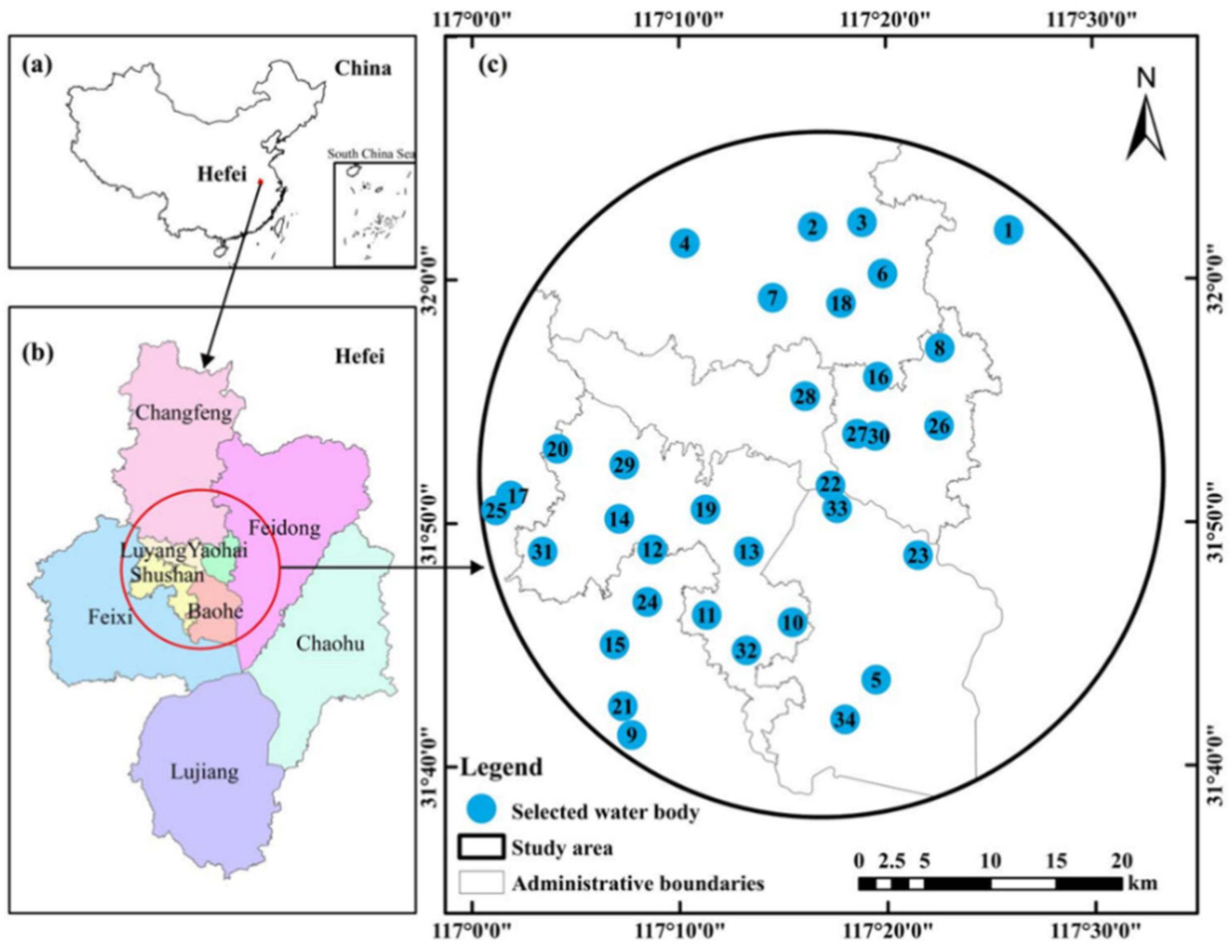
2.1. Study Area
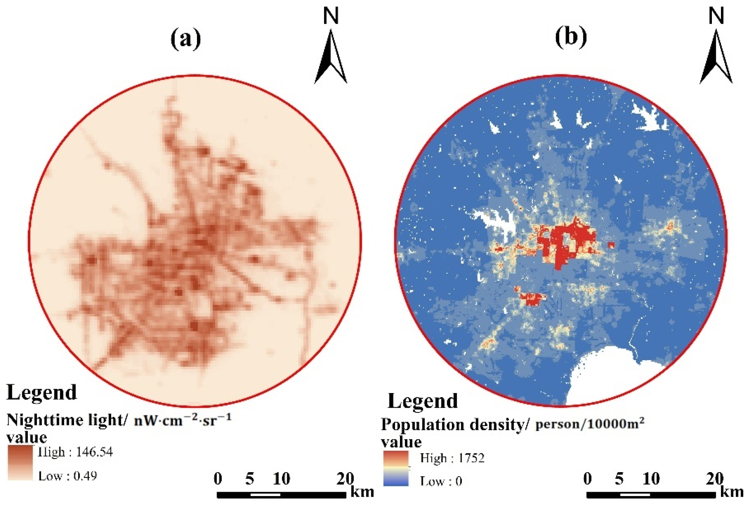
2.2. Data Collection
2.3. Methods
2.3.1. Retrieval of LST
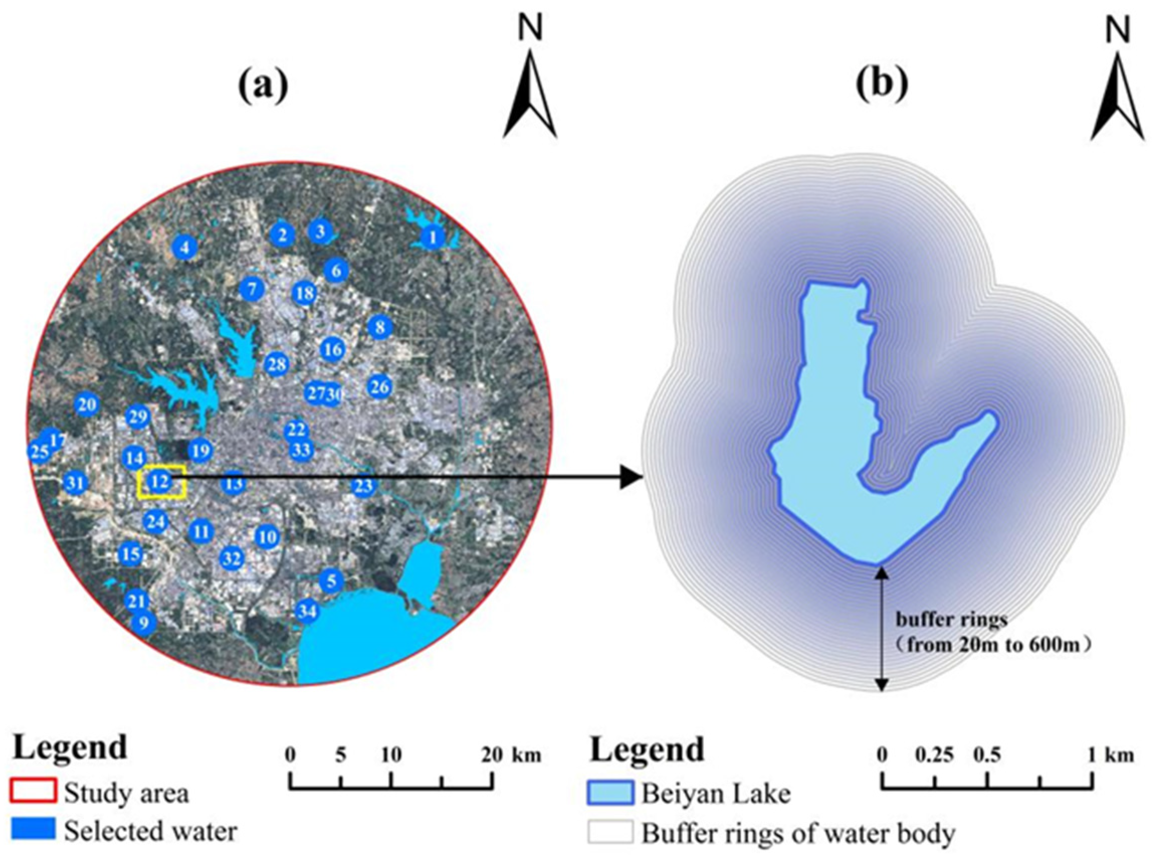
2.3.2. Identification and Selection of Water Bodies
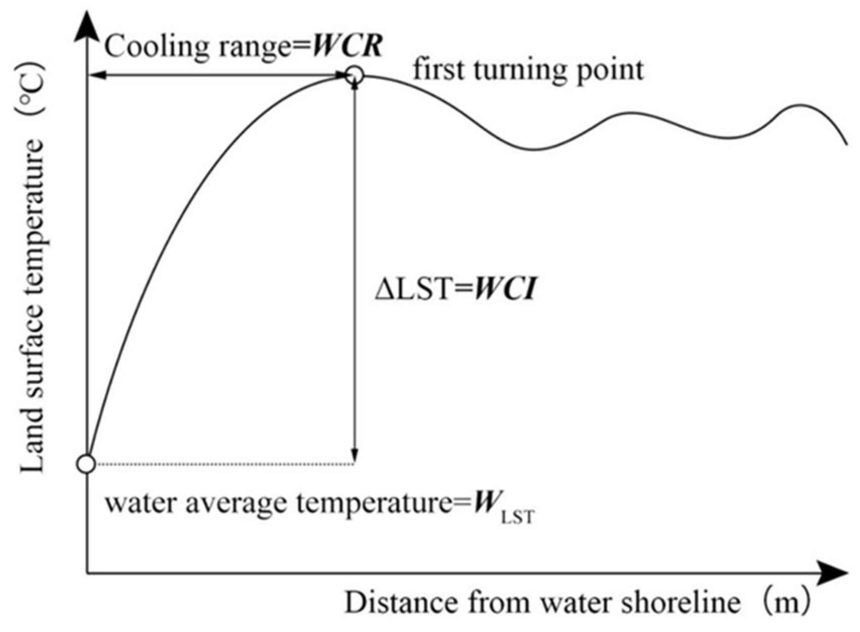
2.3.3. Quantitative Analysis of the UBI Cooling Effect
2.3.4. Choosing Potential Influencing Factors
2.3.5. Statistical Analysis
- (1)
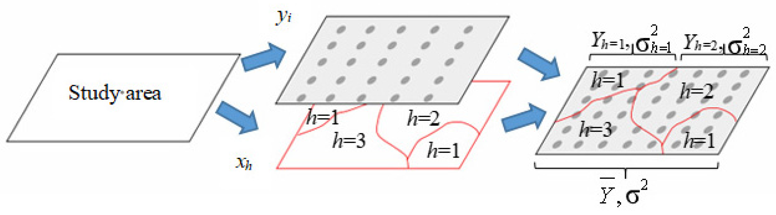
- The factor detector mainly detects to what extent an independent variable (X) explains the spatial variation in the attribute of the dependent variable (Y), and the value is measured by the q value (Figure 5). In this paper, the factor detector was employed to identify the influence of different factors on the spatial variation of the UBI cooling effect. The calculation formula of the q value is [68]:where h = 1, …, L is the layer of impact factor X; Nh and N represent the number of sample units in layer h and the whole region, respectively. and σ2 are the variances of layer h and the variance of the whole region. SSW represents the total of the spatial variance of each layer. SST represents the difference of Y in the whole region. The range of values for q is [0, 1]. The higher the q value, the stronger the explanatory power and contribution of this factor to the spatial differentiation of the UBI cooling effect, and the weaker it is, on the contrary [69,70].
- (2)
- The interaction detector is used to determine the interaction between various factors, that is, whether two factors work interact to enhance or diminish the explanatory power of the dependent variable (Y) or whether the effects of such factors on Y are independent of each other, which means the factor’s influence on the UBI cooling effect is likely to be independent and can also be combined. Different from traditional statistical methods, such as logistic regression hypothesis multiplication, interaction detectors can be detected as long as there is interaction [71,72]. The evaluation method is to overlay geography layers X1 and X2 to create a new geography layer Y. Compare the q values of Y, X1, and X2 to judge the effect of the interaction (Table 2) [63].
3. Results
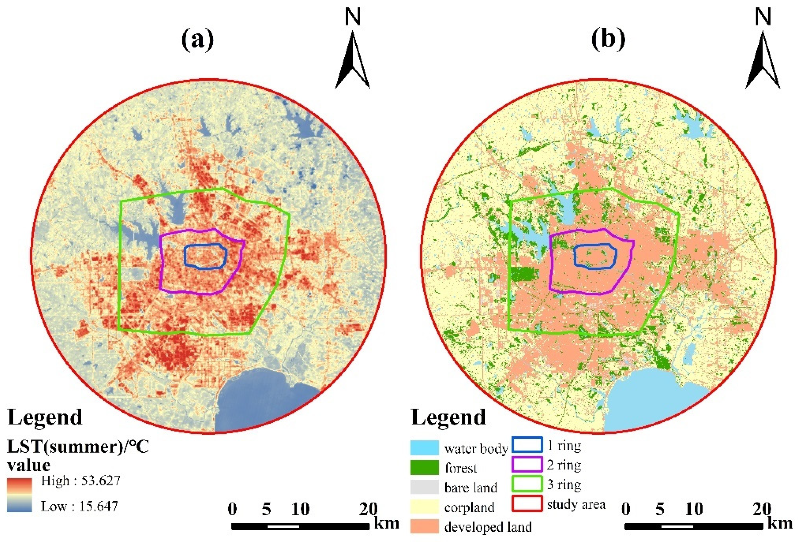
3.1. Spatial Characteristics of UBI and LST
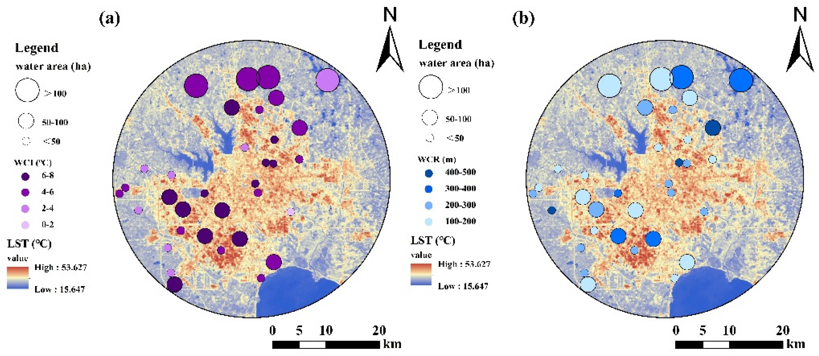
3.2. The Cooling Effect of UBI
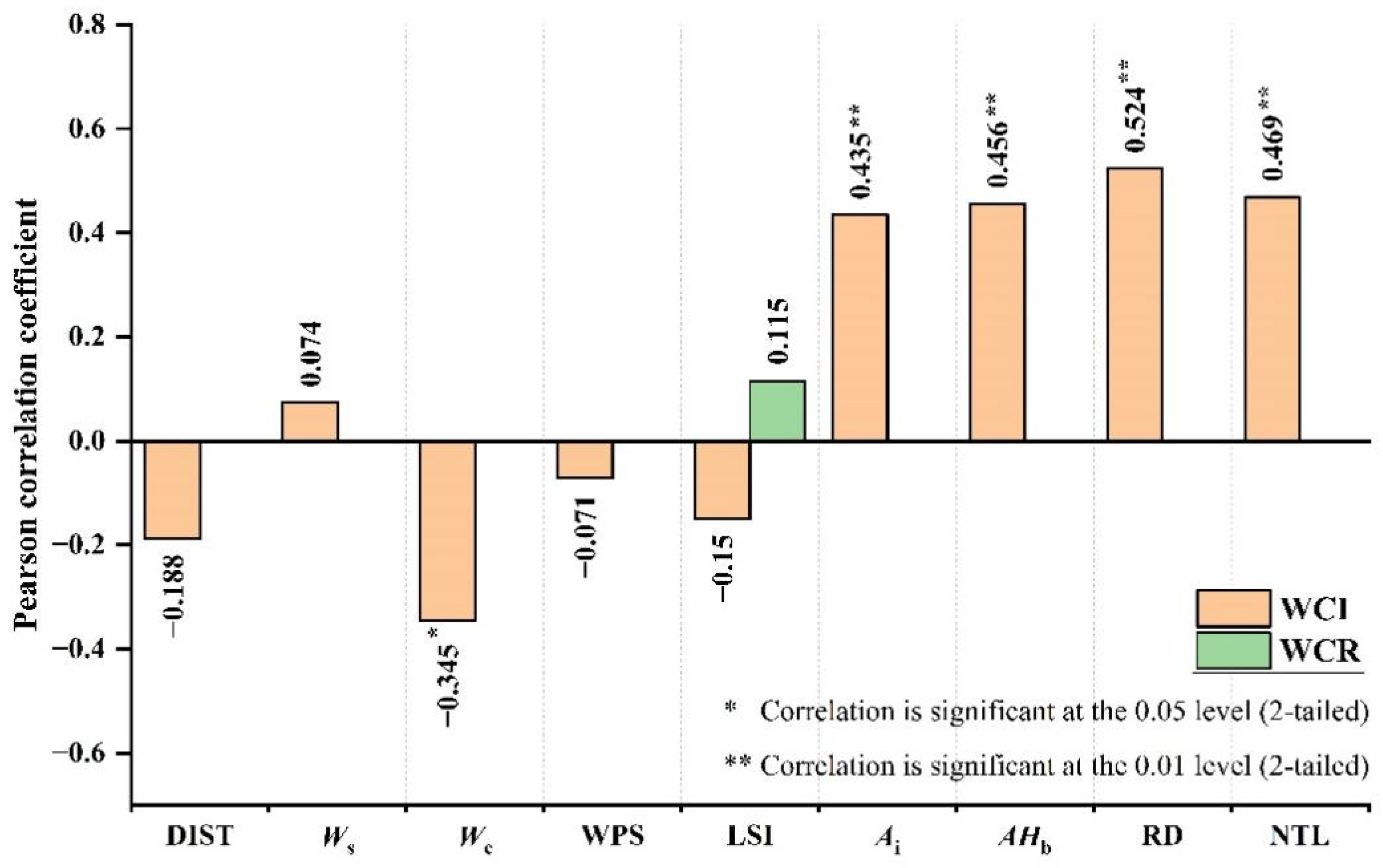
3.3. Influencing Factor Analysis of UBI Cooling Effect
4. Discussion
4.1. The Effects of UBI on LST
4.2. Implications for UBI Landscape Planning and Management
4.3. Limitations of this Study and Research Directions in the Future
5. Conclusions
- (1)
- The surface thermal environment of the built-up area of Hefei presented obvious spatial differentiation characteristics. The high-temperature area was mainly concentrated in the core and inner ring area, while the low-temperature area was mainly distributed in the outer ring area and several large reservoirs and forest parks.
- (2)
- Nine factors have a significant influence on WCI, including DIST, Ws, Wc, WPS, LSI, Ai, AHb, RD, and NTL, among which road density had the highest explanatory power for WCI variation. In contrast, only the landscape shape index had a significant impact on WCR variation.
- (3)
- The cooling effect of UBI is the result of the comprehensive effects of environmental characteristics, water body characteristics, and socioeconomic development characteristics. The interaction of the three type factors had a significant effect on WCI and WCR, and the interaction relationship between the influencing factors was mutually enhanced.
Author Contributions
Funding
Data Availability Statement
Acknowledgments
Conflicts of Interest
References
- Zhou, R.; Xu, H.; Zhang, H.; Zhang, J.; Liu, M.; He, T.; Gao, J.; Li, C. Quantifying the Relationship between 2D/3D Building Patterns and Land Surface Temperature: Study on the Metropolitan Shanghai. Remote Sens. 2022, 14, 4098. [Google Scholar] [CrossRef]
- Peng, J.; Xie, P.; Liu, Y.; Ma, J. Urban thermal environment dynamics and associated landscape pattern factors: A case study in the Beijing metropolitan region. Remote Sens. Environ. 2016, 173, 145–155. [Google Scholar] [CrossRef]
- Sun, R.; Lu, Y.; Yang, X.; Chen, L. Understanding the variability of urban heat islands from local background climate and urbanization. J. Clean. Prod. 2019, 208, 743–752. [Google Scholar] [CrossRef]
- Akbari, H.; Kolokotsa, D. Three decades of urban heat islands and mitigation technologies research. Energy Build. 2016, 133, 834–842. [Google Scholar] [CrossRef]
- Cao, Q.; Yu, D.; Georgescu, M.; Wu, J.; Wang, W. Impacts of future urban expansion on summer climate and heat-related human health in eastern China. Environ. Int. 2018, 112, 134–146. [Google Scholar] [CrossRef] [PubMed]
- Sun, Y.; Augenbroe, G. Urban heat island effect on energy application studies of office buildings. Energy Build. 2014, 77, 171–179. [Google Scholar] [CrossRef]
- Martins, T.A.L.; Adolphe, L.; Bonhomme, M.; Bonneaud, F.; Faraut, S.; Ginestet, S.; Michel, C.; Guyard, W. Impact of Urban Cool Island measures on outdoor climate and pedestrian comfort: Simulations for a new district of Toulouse, France. Sustain. Cities Soc. 2016, 26, 9–26. [Google Scholar] [CrossRef]
- Nesshover, C.; Assmuth, T.; Irvine, K.N.; Rusch, G.M.; Waylen, K.A.; Delbaere, B.; Haase, D.; Jones-Walters, L.; Keune, H.; Kovacs, E.; et al. The science, policy and practice of nature-based solutions: An interdisciplinary perspective. Sci. Total Environ. 2017, 579, 1215–1227. [Google Scholar] [CrossRef] [PubMed]
- Amani-Beni, M.; Zhang, B.; Xie, G.-D.; Xu, J. Impact of urban park’s tree, grass and waterbody on microclimate in hot summer days: A case study of Olympic Park in Beijing, China. Urban For. Urban Green. 2018, 32, 1–6. [Google Scholar] [CrossRef]
- Moss, J.L.; Doick, K.J.; Smith, S.; Shahrestani, M. Influence of evaporative cooling by urban forests on cooling demand in cities. Urban For. Urban Green. 2019, 37, 65–73. [Google Scholar] [CrossRef]
- Sun, R.; Chen, L. Effects of green space dynamics on urban heat islands: Mitigation and diversification. Ecosyst. Serv. 2017, 23, 38–46. [Google Scholar] [CrossRef]
- Chen, L.; Wang, X.; Cai, X.; Yang, C.; Lu, X. Combined Effects of Artificial Surface and Urban Blue-Green Space on Land Surface Temperature in 28 Major Cities in China. Remote Sens. 2022, 14, 448. [Google Scholar] [CrossRef]
- Yang, G.; Yu, Z.; Jorgensen, G.; Vejre, H. How can urban blue-green space be planned for climate adaption in high-latitude cities? A seasonal perspective. Sustain. Cities Soc. 2020, 53, 101932. [Google Scholar] [CrossRef]
- Gunawardena, K.R.; Wells, M.J.; Kershaw, T. Utilising green and bluespace to mitigate urban heat island intensity. Sci. Total Environ. 2017, 584, 1040–1055. [Google Scholar] [CrossRef] [PubMed]
- Voelker, S.; Baumeister, H.; Classen, T.; Hornberg, C.; Kistemann, T. Evidence for the temperature-mitigating capacity of urban blue space—A health geographic perspective. Erdkunde 2013, 67, 355–371. [Google Scholar] [CrossRef]
- Wilson, J.S.; Clay, M.; Martin, E.; Stuckey, D.; Vedder-Risch, K. Evaluating environmental influences of zoning in urban ecosystems with remote sensing. Remote Sens. Environ. 2003, 86, 303–321. [Google Scholar] [CrossRef]
- Manteghi, G.; Limit, H.B.; Remaz, D. Water Bodies an Urban Microclimate: A Review. Mod. Appl. Sci. 2015, 9, 97. [Google Scholar] [CrossRef] [Green Version]
- Xue, Z.; Hou, G.; Zhang, Z.; Lyu, X.; Jiang, M.; Zou, Y.; Shen, X.; Wang, J.; Liu, X. Quantifying the cooling-effects of urban and peri-urban wetlands using remote sensing data: Case study of cities of Northeast China. Landsc. Urban Plan. 2019, 182, 92–100. [Google Scholar] [CrossRef]
- Zheng, Y.; Li, Y.; Hou, H.; Murayama, Y.; Wang, R.; Hu, T. Quantifying the Cooling Effect and Scale of Large Inner-City Lakes Based on Landscape Patterns: A Case Study of Hangzhou and Nanjing. Remote Sens. 2021, 13, 1526. [Google Scholar] [CrossRef]
- Brans, K.I.; Engelen, J.M.T.; Souffreau, C.; De Meester, L. Urban hot-tubs: Local urbanization has profound effects on average and extreme temperatures in ponds. Landsc. Urban Plan. 2018, 176, 22–29. [Google Scholar] [CrossRef]
- Du, H.; Song, X.; Jiang, H.; Kan, Z.; Wang, Z.; Cai, Y. Research on the cooling island effects of water body: A case study of Shanghai, China. Ecol. Indic. 2016, 67, 31–38. [Google Scholar] [CrossRef]
- Cheng, L.; Guan, D.; Zhou, L.; Zhao, Z.; Zhou, J. Urban cooling island effect of main river on a landscape scale in Chongqing, China. Sustain. Cities Soc. 2019, 47, 101501. [Google Scholar] [CrossRef]
- Mohajerani, A.; Bakaric, J.; Jeffrey-Bailey, T. The urban heat island effect, its causes, and mitigation, with reference to the thermal properties of asphalt concrete. J. Environ. Manag. 2017, 197, 522–538. [Google Scholar] [CrossRef]
- Bouzouidja, R.; Cannavo, P.; Bodenan, P.; Gulyas, A.; Kiss, M.; Kovacs, A.; Bechet, B.; Chancibault, K.; Chantoiseau, E.; Bournet, P.-E.; et al. How to evaluate nature-based solutions performance for microclimate, water and soil management issues—Available tools and methods from Nature4Cities European project results. Ecol. Indic. 2021, 125, 107556. [Google Scholar] [CrossRef]
- Jacobs, C.; Klok, L.; Bruse, M.; Cortesao, J.; Lenzholzer, S.; Kluck, J. Are urban water bodies really cooling? Urban Clim. 2020, 32, 100607. [Google Scholar] [CrossRef]
- Tominaga, Y.; Sato, Y.; Sadohara, S. CFD simulations of the effect of evaporative cooling from water bodies in a micro-scale urban environment: Validation and application studies. Sustain. Cities Soc. 2015, 19, 259–270. [Google Scholar] [CrossRef]
- Tan, X.; Sun, X.; Huang, C.; Yuan, Y.; Hou, D. Comparison of cooling effect between green space and water body. Sustain. Cities Soc. 2021, 67, 102711. [Google Scholar] [CrossRef]
- Wu, J.; Li, C.; Zhang, X.; Zhao, Y.; Liang, J.; Wang, Z. Seasonal variations and main influencing factors of the water cooling islands effect in Shenzhen. Ecol. Indic. 2020, 117, 106699. [Google Scholar] [CrossRef]
- Wu, C.; Li, J.; Wang, C.; Song, C.; Chen, Y.; Finka, M.; La Rosa, D. Understanding the relationship between urban blue infrastructure and land surface temperature. Sci. Total Environ. 2019, 694, 133742. [Google Scholar] [CrossRef]
- Wang, Y.; Ouyang, W. Investigating the heterogeneity of water cooling effect for cooler cities. Sustain. Cities Soc. 2021, 75, 103281. [Google Scholar] [CrossRef]
- Zhou, W.; Huang, G.; Cadenasso, M.L. Does spatial configuration matter? Understanding the effects of land cover pattern on land surface temperature in urban landscapes. Landsc. Urban Plan. 2011, 102, 54–63. [Google Scholar] [CrossRef]
- Weng, Q.; Liu, H.; Liang, B.; Lu, D. The Spatial Variations of Urban Land Surface Temperatures: Pertinent Factors, Zoning Effect, and Seasonal Variability. IEEE J. Sel. Top. Appl. Earth Obs. Remote Sens. 2008, 1, 154–166. [Google Scholar] [CrossRef]
- Chen, A.; Yao, L.; Sun, R.; Chen, L. How many metrics are required to identify the effects of the landscape pattern on land surface temperature? Ecol. Indic. 2014, 45, 424–433. [Google Scholar] [CrossRef]
- Morabito, M.; Crisci, A.; Messeri, A.; Orlandini, S.; Raschi, A.; Maracchi, G.; Munafo, M. The impact of built-up surfaces on land surface temperatures in Italian urban areas. Sci. Total Environ. 2016, 551, 317–326. [Google Scholar] [CrossRef]
- Sun, Q.; Wu, Z.; Tan, J. The relationship between land surface temperature and land use/land cover in Guangzhou, China. Environ. Earth Sci. 2012, 65, 1687–1694. [Google Scholar] [CrossRef]
- Asgarian, A.; Amiri, B.J.; Sakieh, Y. Assessing the effect of green cover spatial patterns on urban land surface temperature using landscape metrics approach. Urban Ecosyst. 2015, 18, 209–222. [Google Scholar] [CrossRef]
- Huang, X.; Wang, Y. Investigating the effects of 3D urban morphology on the surface urban heat island effect in urban functional zones by using high-resolution remote sensing data: A case study of Wuhan, Central China. Isprs J. Photogramm. Remote Sens. 2019, 152, 119–131. [Google Scholar] [CrossRef]
- Peng, J.; Jia, J.; Liu, Y.; Li, H.; Wu, J. Seasonal contrast of the dominant factors for spatial distribution of land surface temperature in urban areas. Remote Sens. Environ. 2018, 215, 255–267. [Google Scholar] [CrossRef]
- Liao, Y.; Wang, J.; Du, W.; Gao, B.; Liu, X.; Chen, G.; Song, X.; Zheng, X. Using Spatial Analysis to Understand the Spatial Heterogeneity of Disability Employment in China. Trans. GIS 2017, 21, 647–660. [Google Scholar] [CrossRef]
- Liao, Y.; Zhang, Y.; He, L.; Wang, J.; Liu, X.; Zhang, N.; Xu, B. Temporal and Spatial Analysis of Neural Tube Defects and Detection of Geographical Factors in Shanxi Province, China. PLoS ONE 2016, 11, e0150332. [Google Scholar] [CrossRef]
- Huang, J.; Wang, J.; Bo, Y.; Xu, C.; Hu, M.; Huang, D. Identification of Health Risks of Hand, Foot and Mouth Disease in China Using the Geographical Detector Technique. Int. J. Environ. Res. Public Health 2014, 11, 3407–3423. [Google Scholar] [CrossRef] [PubMed]
- Tan, J.; Zhang, P.; Lo, K.; Li, J.; Liu, S. The Urban Transition Performance of Resource-Based Cities in Northeast China. Sustainability 2016, 8, 1022. [Google Scholar] [CrossRef] [Green Version]
- Xu, Q.; Zheng, X.; Zhang, C. Quantitative Analysis of the Determinants Influencing Urban Expansion: A Case Study in Beijing, China. Sustainability 2018, 10, 1630. [Google Scholar] [CrossRef] [Green Version]
- Ren, Y.; Deng, L.-Y.; Zuo, S.-D.; Song, X.-D.; Liao, Y.-L.; Xu, C.-D.; Chen, Q.; Hua, L.-Z.; Li, Z.-W. Quantifying the influences of various ecological factors on land surface temperature of urban forests. Environ. Pollut. 2016, 216, 519–529. [Google Scholar] [CrossRef] [Green Version]
- Wu, R.; Zhang, J.; Bao, Y.; Zhang, F. Geographical Detector Model for Influencing Factors of Industrial Sector Carbon Dioxide Emissions in Inner Mongolia, China. Sustainability 2016, 8, 149. [Google Scholar] [CrossRef] [Green Version]
- Ju, H.; Zhang, Z.; Zuo, L.; Wang, J.; Zhang, S.; Wang, X.; Zhao, X. Driving forces and their interactions of built-up land expansion based on the geographical detector—A case study of Beijing, China. Int. J. Geogr. Inf. Sci. 2016, 30, 2188–2207. [Google Scholar] [CrossRef]
- Ren, Y.; Deng, L.; Zuo, S.; Luo, Y.; Shao, G.; Wei, X.; Hua, L.; Yang, Y. Geographical modeling of spatial interaction between human activity and forest connectivity in an urban landscape of southeast China. Landsc. Ecol. 2014, 29, 1741–1758. [Google Scholar] [CrossRef]
- Li, Y.; Liu, Y.; Ranagalage, M.; Zhang, H.; Zhou, R. Examining Land Use/Land Cover Change and the Summertime Surface Urban Heat Island Effect in Fast-Growing Greater Hefei, China: Implications for Sustainable Land Development. ISPRS Int. J. Geo-Inf. 2020, 9, 568. [Google Scholar] [CrossRef]
- Sun, J.; Ongsomwang, S. Impact of Multitemporal Land Use and Land Cover Change on Land Surface Temperature Due to Urbanization in Hefei City, China. ISPRS Int. J. Geo-Inf. 2021, 10, 809. [Google Scholar] [CrossRef]
- Jimenez-Munoz, J.; Sobrino, J.; Skokovic, D.; Mattar, C.; Cristobal, J. Land Surface Temperature Retrieval Methods from Landsat-8 Thermal Infrared Sensor Data. IEEE Geosci. Remote Sens. Lett. 2014, 11, 1840–1843. [Google Scholar] [CrossRef]
- Yu, X.; Guo, X.; Wu, Z. Land Surface Temperature Retrieval from Landsat 8 TIRS—Comparison between Radiative Transfer Equation-Based Method, Split Window Algorithm and Single Channel Method. Remote Sens. 2014, 6, 9829–9852. [Google Scholar] [CrossRef] [Green Version]
- Sobrino, J.; Jimenez-Munoz, J.; Paolini, L. Land surface temperature retrieval from LANDSAT TM 5. Remote Sens. Environ. 2004, 90, 434–440. [Google Scholar] [CrossRef]
- Windahl, E.; de Beurs, K. An intercomparison of Landsat land surface temperature retrieval methods under variable atmospheric conditions using in situ skin temperature. Int. J. Appl. Earth Obs. Geoinf. 2016, 51, 11–27. [Google Scholar] [CrossRef] [Green Version]
- Yu, Z.; Guo, X.; Jorgensen, G.; Vejre, H. How can urban green spaces be planned for climate adaptation in subtropical cities? Ecol. Indic. 2017, 82, 152–162. [Google Scholar] [CrossRef]
- Chander, G.; Markham, B.L.; Helder, D.L. Summary of current radiometric calibration coefficients for Landsat MSS, TM, ETM+, and EO-1 ALI sensors. Remote Sens. Environ. 2009, 113, 893–903. [Google Scholar] [CrossRef]
- Mildrexler, D.J.; Zhao, M.; Running, S.W. A global comparison between station air temperatures and MODIS land surface temperatures reveals the cooling role of forests. J. Geophys. Res.-Biogeosci. 2011, 116, G0302. [Google Scholar] [CrossRef]
- Xu, H. A Study on Information Extraction of Water Body with the Modified Normalized Difference Water Index (MNDWI). J. Remote Sens. 2005, 9, 589–595. [Google Scholar] [CrossRef]
- Wang, Y.; Zhan, Q.; Ouyang, W. How to quantify the relationship between spatial distribution of urban waterbodies and land surface temperature? Sci. Total Environ. 2019, 671, 126630. [Google Scholar] [CrossRef]
- Yu, Z.; Yang, G.; Zuo, S.; Jorgensen, G.; Koga, M.; Vejre, H. Critical review on the cooling effect of urban blue-green space: A threshold-size perspective. Urban For. Urban Green. 2020, 49, 126630. [Google Scholar] [CrossRef]
- Peng, J.; Liu, Q.; Xu, Z.; Lyu, D.; Du, Y.; Qiao, R.; Wu, J. How to effectively mitigate urban heat island effect? A perspective of waterbody patch size threshold. Landsc. Urban Plan. 2020, 202, 103873. [Google Scholar] [CrossRef]
- Sun, R.; Chen, L. How can urban water bodies be designed for climate adaptation? Landsc. Urban Plan. 2012, 105, 27–33. [Google Scholar] [CrossRef]
- Zhang, J.; Jie, G.; Liu, D. Dynamics and Driving Factors of Landscape Fragmentation Based on Geo Detector in the Bailongjiang Watershed of Gansu Province. Sci. Geogr. Sin. 2018, 38, 1370–1378. [Google Scholar] [CrossRef]
- Wang, J.-F.; Hu, Y. Environmental health risk detection with GeogDetector. Environ. Model. Softw. 2012, 33, 114–115. [Google Scholar] [CrossRef]
- Zhan, D.; Zhang, W.; Jianhui, Y.U.; Meng, B.; Dang, Y. Analysis of influencing mechanism of residents’ livability satisfaction in Beijing using geographical detector. Prog. Geogr. 2015, 34, 966–975. [Google Scholar] [CrossRef] [Green Version]
- Luo, W.; Jasiewicz, J.; Stepinski, T.; Wang, J.F.; Xu, C.D.; Cang, X.Z. Spatial association between dissection density and environmental factors over the entire conterminous United States. Geophys. Res. Lett. 2016, 43, 692–700. [Google Scholar] [CrossRef] [Green Version]
- Wang, J.; Xu, C. Geodetector: Principle and prospective. Acta Geogr. Sin. 2017, 72, 116–134. [Google Scholar] [CrossRef]
- Wang, J.-F.; Li, X.-H.; Christakos, G.; Liao, Y.-L.; Zhang, T.; Gu, X.; Zheng, X.-Y. Geographical Detectors-Based Health Risk Assessment and its Application in the Neural Tube Defects Study of the Heshun Region, China. Int. J. Geogr. Inf. Sci. 2010, 24, 107–127. [Google Scholar] [CrossRef]
- Bai, L.; Jiang, L.; Yang, D.Y.; Liu, Y.B. Quantifying the spatial heterogeneity influences of natural and socioeconomic factors and their interactions on air pollution using the geographical detector method: A case study of the Yangtze River Economic Belt, China. J. Clean. Prod. 2019, 232, 692–704. [Google Scholar] [CrossRef]
- Hu, Y.; Wang, J.; Li, X.; Ren, D.; Zhu, J. Geographical Detector-Based Risk Assessment of the Under-Five Mortality in the 2008 Wenchuan Earthquake, China. PLoS ONE 2011, 6, e21427. [Google Scholar] [CrossRef] [Green Version]
- Wang, J.; Zhang, T.; Fu, B. A measure of spatial stratified heterogeneity. Ecol. Indic. 2016, 67, 250–256. [Google Scholar] [CrossRef]
- Wang, H.; Gao, J.; Hou, W. Quantitative attribution analysis of soil erosion in different morphological types of geomorphology in karst areas: Based on the geographical detector method. Acta Geogr. Sin. 2018, 73, 1674–1686. [Google Scholar] [CrossRef]
- Hu, D.; Meng, Q.; Zhang, L.; Zhang, Y. Spatial quantitative analysis of the potential driving factors of land surface temperature in different “Centers” of polycentric cities: A case study in Tianjin, China. Sci. Total Environ. 2020, 706, 135244. [Google Scholar] [CrossRef] [PubMed]
- Min, M.; Lin, C.; Duan, X.; Jin, Z.; Zhang, L. Spatial distribution and driving force analysis of urban heat island effect based on raster data: A case study of the Nanjing metropolitan area, China. Sustain. Cities Soc. 2019, 50, 101637. [Google Scholar] [CrossRef]
- Deilami, K.; Kamruzzaman, M.; Liu, Y. Urban heat island effect: A systematic review of spatio-temporal factors, data, methods, and mitigation measures. Int. J. Appl. Earth Obs. Geoinf. 2018, 67, 30–42. [Google Scholar] [CrossRef]
- Estoque, R.C.; Murayama, Y.; Myint, S.W. Effects of landscape composition and pattern on land surface temperature: An urban heat island study in the megacities of Southeast Asia. Sci. Total Environ. 2017, 577, 349–359. [Google Scholar] [CrossRef]
- Wu, D.; Wang, Y.; Fan, C.; Xia, B. Thermal environment effects and interactions of reservoirs and forests as urban blue-green infrastructures. Ecol. Indic. 2018, 91, 657–663. [Google Scholar] [CrossRef]
- Wu, S.; Yang, H.; Luo, P.; Luo, C.; Li, H.; Liu, M.; Ruan, Y.; Zhang, S.; Xiang, P.; Jia, H.; et al. The effects of the cooling efficiency of urban wetlands in an inland megacity: A case study of Chengdu, Southwest China. Build. Environ. 2021, 204, 108128. [Google Scholar] [CrossRef]
- Kabisch, N.; Frantzeskaki, N.; Pauleit, S.; Naumann, S.; Davis, M.; Artmann, M.; Haase, D.; Knapp, S.; Korn, H.; Stadler, J.; et al. Nature-based solutions to climate change mitigation and adaptation in urban areas: Perspectives on indicators, knowledge gaps, barriers, and opportunities for action. Ecol. Soc. 2016, 21, 39. [Google Scholar] [CrossRef] [Green Version]
- Curado, N.; Hartel, T.; Arntzen, J.W. Amphibian pond loss as a function of landscape change—A case study over three decades in an agricultural area of northern France. Biol. Conserv. 2011, 144, 1610–1618. [Google Scholar] [CrossRef]
- Chou, W.-W.; Lee, S.-H.; Wu, C.-F. Evaluation of the Preservation Value and Location of Farm Ponds in Yunlin County, Taiwan. Int. J. Environ. Res. Public Health 2014, 11, 548–572. [Google Scholar] [CrossRef]
- Biggs, J.; Williams, P.; Whitfield, M.; Nicolet, P.; Weatherby, A. 15 years of pond assessment in Britain: Results and lessons learned from the work of Pond Conservation. Aquat. Conserv.-Mar. Freshw. Ecosyst. 2005, 15, 693–714. [Google Scholar] [CrossRef]
- Sun, R.; Chen, A.; Chen, L.; Lu, Y. Cooling effects of wetlands in an urban region: The case of Beijing. Ecol. Indic. 2012, 20, 57–64. [Google Scholar] [CrossRef]
- Yu, Z.; Fan, H.; Yang, G.; Liu, T.Y.; Vejre, H. How to cool hot-humid (Asian) cities with urban trees? An optimal landscape size perspective. Agric. For. Meteorol. 2019, 265, 338–348. [Google Scholar] [CrossRef]


| Indicator | Formula and Range | Definition | |
|---|---|---|---|
| Environmental characteristics | Distance of surrounding water system (DIST) | DIST ≥ 0 | The distance to the surrounding water system (m) |
| Percentage of vegetation (Pv) | Pv ≥ 0 | The percentage of vegetation in the buffer zone of water body (m2) | |
| Water slope (Ws) | Ws ≥ 0 | The slope within the water body area | |
| Water elevation (We) | We ≥ 0 | The elevation within the water body area | |
| Water connectivity (Wc) | 0; 1 | 0 for the disconnect in the past; 1 for connecting in the past (to the water body) | |
| Water body characteristics | Water patch size (WPS) | WPS ≥ 0 | The area of water body (ha) |
| Landscape shape index (LSI) | , LSI ≥ 1 | The shape index of water body. | |
| Socioeconomic development characteristics | Area of impervious surfaces (Ai) | Ai ≥ 0 | The area of impervious surfaces in the buffer zone of water body (m2) |
| Average building height (AHb) | AHb ≥ 0 | The average building height in the buffer zone of water body (m) | |
| Road density (RD) | RD ≥ 0 | The density of roads in the buffer zone of water body (m/m2) | |
| NTL | NTL ≥ 0 | The mean nighttime light in the buffer zone of water body |
| Graphic | Judgment Based | Interaction |
|---|---|---|
 | q(X1∩X2) < Min(q(X1),q(X2)) | Weaken, nonlinear |
 | Min(q(X1),q(X2)) < q(X1∩X2) < Max(q(X1),q(X2)) | Weaken, single factor nonlinear |
 | q(X1∩X2) > Max(q(X1),q(X2)) | Enhanced, double factors |
 | q(X1∩X2) = q(X1) + q(X2) | Independent |
 | q(X1∩X2) > q(X1) + q(X2) | Enhanced, nonlinear |
| Area | Mean Water LST (°C) | Mean LST (°C) |
|---|---|---|
| The core area (the area within the 1 ring) | 29.88 | 35.06 |
| The inner ring area (the area between the 1 ring and 2 ring) | 30.06 | 35.24 |
| The central area (the area between the 2 ring and 3 ring) | 29.28 | 33.67 |
| The outer ring area (the area between 3 ring and study boundary) | 27.76 | 30.95 |
| Influencing Factors | Factors | q (WCI) | q (WCR) |
|---|---|---|---|
| Environmental characteristics | Distance of surrounding water system (DIST) | 0.133 ** | 0.083 |
| Percentage of vegetation (Pv) | 0.136 | 0.050 | |
| Water slope (Ws) | 0.260 * | 0.267 | |
| Water elevation (We) | 0.170 | 0.143 | |
| Water connectivity (Wc) | 0.119 * | 0.020 | |
| Water body characteristics | Water patch size (WPS) | 0.340 * | 0.042 |
| Landscape shape index (LSI) | 0.260 ** | 0.181 * | |
| Socioeconomic development characteristics | Area of impervious (Ai) | 0.167 ** | 0.066 |
| Average building height (AHb) | 0.191 ** | 0.036 | |
| Road density (RD) | 0.359 ** | 0.065 | |
| NTL | 0.168 * | 0.054 |
| DIST | Pv | Ws | We | Wc | WPS | LSI | Ai | AHb | RD | NTL | |
|---|---|---|---|---|---|---|---|---|---|---|---|
| DIST | |||||||||||
| Pv | 0.30B | ||||||||||
| Ws | 0.55N | 0.45N | |||||||||
| We | 0.52N | 0.39N | 0.41B | ||||||||
| Wc | 0.30B | 0.29B | 0.38B | 0.32B | |||||||
| WPS | 0.55N | 0.64N | 0.56B | 0.44B | 0.39B | ||||||
| LSI | 0.52N | 0.47N | 0.41B | 0.52N | 0.33B | 0.56B | |||||
| Ai | 0.34B | 0.23B | 0.35B | 0.39B | 0.31B | 0.46B | 0.43B | ||||
| AHb | 0.38N | 0.25B | 0.36B | 0.35B | 0.33B | 0.50B | 0.55N | 0.26B | |||
| RD | 0.62N | 0.41B | 0.46B | 0.48B | 0.39B | 0.68B | 0.56B | 0.39B | 0.45B | ||
| NTL | 0.40N | 0.26B | 0.41B | 0.45N | 0.31B | 0.64N | 0.44B | 0.31B | 0.30B | 0.45B |
| DIST | Pv | Ws | We | Wc | WPS | LSI | Ai | AHb | RD | NTL | |
|---|---|---|---|---|---|---|---|---|---|---|---|
| DIST | |||||||||||
| Pv | 0.23N | ||||||||||
| Ws | 0.46N | 0.35B | |||||||||
| We | 0.26B | 0.25N | 0.36B | ||||||||
| Wc | 0.15B | 0.12B | 0.29B | 0.19B | |||||||
| WPS | 0.33N | 0.18N | 0.35B | 0.22B | 0.07B | ||||||
| LSI | 0.27B | 0.33N | 0.52N | 0.32B | 0.23B | 0.23B | |||||
| Ai | 0.20B | 0.15B | 0.36B | 0.34N | 0.25N | 0.38N | 0.38N | ||||
| AHb | 0.22N | 0.18N | 0.38N | 0.26N | 0.12N | 0.20N | 0.24B | 0.21N | |||
| RD | 0.19B | 0.12B | 0.37B | 0.26N | 0.13B | 0.24N | 0.28B | 0.17B | 0.14B | ||
| NTL | 0.22N | 0.18N | 0.37B | 0.31N | 0.13B | 0.16N | 0.27B | 0.20N | 0.18N | 0.19N |
Publisher’s Note: MDPI stays neutral with regard to jurisdictional claims in published maps and institutional affiliations. |
© 2022 by the authors. Licensee MDPI, Basel, Switzerland. This article is an open access article distributed under the terms and conditions of the Creative Commons Attribution (CC BY) license (https://creativecommons.org/licenses/by/4.0/).
Share and Cite
Li, Y.; Xia, M.; Ma, Q.; Zhou, R.; Liu, D.; Huang, L. Identifying the Influencing Factors of Cooling Effect of Urban Blue Infrastructure Using the Geodetector Model. Remote Sens. 2022, 14, 5495. https://doi.org/10.3390/rs14215495
Li Y, Xia M, Ma Q, Zhou R, Liu D, Huang L. Identifying the Influencing Factors of Cooling Effect of Urban Blue Infrastructure Using the Geodetector Model. Remote Sensing. 2022; 14(21):5495. https://doi.org/10.3390/rs14215495
Chicago/Turabian StyleLi, Yingying, Min Xia, Qun Ma, Rui Zhou, Dan Liu, and Leichang Huang. 2022. "Identifying the Influencing Factors of Cooling Effect of Urban Blue Infrastructure Using the Geodetector Model" Remote Sensing 14, no. 21: 5495. https://doi.org/10.3390/rs14215495
APA StyleLi, Y., Xia, M., Ma, Q., Zhou, R., Liu, D., & Huang, L. (2022). Identifying the Influencing Factors of Cooling Effect of Urban Blue Infrastructure Using the Geodetector Model. Remote Sensing, 14(21), 5495. https://doi.org/10.3390/rs14215495