
Comprehensive Analysis of PERSIANN Products in Studying the Precipitation Variations over Luzon


Abstract
:
1. Introduction
2. Data and Methodology
2.1. Data
2.2. Methods
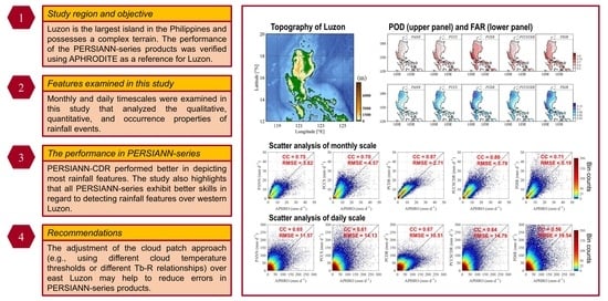
3. Results
3.1. Climatological and Monthly Features
3.2. Daily Features
4. Conclusions and Discussion
Supplementary Materials
Author Contributions
Funding
Data Availability Statement
Acknowledgments
Conflicts of Interest
References
- Chen, C.; Li, Z.; Song, Y.; Duan, Z.; Mo, K.; Wang, Z.; Chen, Q. Performance of Multiple Satellite Precipitation Estimates over a Typical Arid Mountainous Area of China: Spatiotemporal Patterns and Extremes. J. Hydrometeorol. 2020, 21, 533–550. [Google Scholar] [CrossRef]
- Huang, W.-R.; Hsu, J.; Liu, P.-Y.; Deng, L. Multiple satellite-observed long-term changes in the summer diurnal precipitation over Luzon and its adjacent seas during 2000–2019. Int. J. Appl. Earth Obs. Geoinf. 2022, 110, 102816. [Google Scholar] [CrossRef]
- Huang, W.-R.; Liu, P.-Y.; Hsu, J. Multiple timescale assessment of wet season precipitation estimation over Taiwan using the PERSIANN family products. Int. J. Appl. Earth Obs. Geoinf. 2021, 103, 102521. [Google Scholar] [CrossRef]
- Hsu, J.; Huang, W.R.; Liu, P.Y. Performance assessment of GPM-based near-real-time satellite products in depicting diurnal precipitation variation over Taiwan. J. Hydrol. Reg. Stud. 2021, 38, 100957. [Google Scholar] [CrossRef]
- Huang, W.R.; Chang, Y.H.; Liu, P.Y. Assessment of IMERG precipitation over Taiwan at multiple timescales. Atmos. Res. 2018, 214, 239–249. [Google Scholar] [CrossRef]
- Hsu, J.; Huang, W.-R.; Liu, P.-Y.; Li, X. Validation of CHIRPS Precipitation Estimates over Taiwan at Multiple Timescales. Remote Sens. 2021, 13, 254. [Google Scholar] [CrossRef]
- Flores, J.F.; Balagot, V.F. Climate of the Philippines. Climates of Northern and Eastern Asia; Arakawa, H., Ed.; World Survey of Climatology; Elsevier: Amsterdam, The Netherlands, 1969; Volume 8, pp. 159–213. [Google Scholar]
- Hong, Y.; Hsu, K.L.; Sorooshian, S.; Gao, X. Precipitation estimation from remotely sensed imagery using an artificial neural network cloud classification system. J. Appl. Meteorol. 2004, 43, 1834–1853. [Google Scholar] [CrossRef] [Green Version]
- Nguyen, P.; Ombadi, M.; Sorooshian, S.; Hsu, K.; AghaKouchak, A.; Braithwaite, D.; Ashouri, H.; Thorstensen, A.R. The PERSIANN family of global satellite precipitation data: A review and evaluation of products. Hydrol. Earth Syst. Sci. 2018, 22, 5801–5816. [Google Scholar] [CrossRef] [Green Version]
- Salmani-Dehaghi, N.; Samani, N. Spatiotemporal Assessment of the PERSIANN Family of Satellite Precipitation Data over Fars Province, Iran. Theor. Appl. Climatol. 2019, 138, 1333–1357. [Google Scholar] [CrossRef]
- Islam, A.; Yu, B.; Cartwright, N. Assessment and comparison of five satellite precipitation products in Australia. J. Hydrol. 2020, 590, 125474. [Google Scholar] [CrossRef]
- Ramos, M.D.; Tendencia, E.; Espana, K.; Sabido, J.; Bagtasa, G. Assessment of Satellite Precipitation Products in the Philippine Archipelago. Int. Arch. Photogramm. Remote Sens. Spat. Inf. Sci 2016, XLI-B1, 423–427. [Google Scholar] [CrossRef] [Green Version]
- Peralta, J.C.A.; Narisma, G.T.; Cruz, F.A. Validation of High-Resolution Gridded Rainfall Datasets for Climate Applications in the Philippines. J. Hydrometeorol. 2020, 21, 1571–1587. [Google Scholar] [CrossRef]
- Aryastana, P.; Liu, C.Y.; Jou, B.J.D.; Cayanan, E.; Punay, J.P.; Chen, Y.N. Assessment of Satellite Precipitation Data Sets for High Variability and Rapid Evolution of Typhoon Precipitation Events in the Philippines. Earth Space Sci. 2022, 9, e2022EA002382. [Google Scholar] [CrossRef]
- Ramage, C.S. Monsoon Meteorology, 1st ed.; Academic Press: New York, NY, USA, 1971. [Google Scholar]
- Yen, M.C.; Chen, T.C. Seasonal variation of the rainfall over Taiwan. Int. J. Climatol. 2000, 20, 803–809. [Google Scholar] [CrossRef]
- Ahmadi, M.; Kashki, A.; Dadashi Roudbari, A. Spatial modeling of seasonal precipitation-elevation in Iran based on aphrodite database. Model. Earth Syst. Environ. 2018, 4, 619–633. [Google Scholar] [CrossRef]
- Yatagai, A.; Kamiguchi, K.; Arakawa, O.; Hamada, A.; Yasutomi, N.; Kitoh, A. APHRODITE: Constructing a long-term daily gridded precipitation dataset for Asia based on a dense network of rain gauges. Bull. Am. Meteorol. Soc. 2012, 93, 1401–1415. [Google Scholar] [CrossRef]
- Hsu, K.; Gao, X.; Sorooshian, S.; Gupta, H.V. Precipitation estimation from remotely sensed information using artificial neural networks. J. Appl. Meteorol. 1997, 36, 1176–1190. [Google Scholar] [CrossRef]
- Ashouri, H.; Hsu, K.-L.; Sorooshian, S.; Braithwaite, D.K.; Knapp, K.R.; Cecil, L.D.; Nelson, B.R.; Prat, O.P. PERSIANN-CDR: Daily precipitation climate data record from multisatellite observations for hydrological and climate studies. Bull. Am. Meteorol. Soc. 2015, 96, 69–83. [Google Scholar] [CrossRef] [Green Version]
- Adler, R.F.; Huffman, G.J.; Chang, A.; Ferraro, R.; Xie, P.P.; Janowiak, J.; Rudolf, B.; Schneider, U.; Curtis, S.; Bolvin, D.; et al. The version-2 global precipitation climatology project (GPCP) monthly precipitation analysis (1979–present). J. Hydrometeorol. 2003, 4, 1147–1167. [Google Scholar] [CrossRef]
- Sadeghi, M.; Nguyen, P.; Naeini, M.R.; Hsu, K.; Braithwaite, D.; Sorooshian, S. PERSIANN-CCS-CDR, a 3-hourly 0.04° global precipitation climate data record for heavy precipitation studies. Sci. Data 2021, 8, 157. [Google Scholar] [CrossRef]
- Nguyen, P.; Ombadi, M.; Gorooh, V.A.; Shearer, E.J.; Sadeghi, M.; Sorooshian, S.; Hsu, K.; Bolvin, D.; Ralph, M.F. Persiann dynamic infrared–rain rate (PDIR-now): A near-real-time, quasi-global satellite precipitation dataset. J. Hydrometeorol. 2020, 21, 2893–2906. [Google Scholar] [CrossRef] [PubMed]
- Fick, S.E.; Hijmans, R.J. WorldClim 2: New 1-km spatial resolution climate surfaces for global land areas. Int. J. Climatol. 2017, 37, 4302–4315. [Google Scholar] [CrossRef]
- Hersbach, H.; Bell, B.; Berrisford, P.; Hirahara, S.; Horanyi, A.; Muñoz-Sabater, J.; Nicolas, J.; Peubey, C.; Radu, R.; Schepers, D.; et al. The ERA5 global reanalysis. Q. J. R. Meteorol. Soc. 2020, 146, 1999–2049. [Google Scholar] [CrossRef]
- Lee, C.-A.; Huang, W.-R.; Chang, Y.-H.; Huang, S.-M. Impact of multiple-scale circulation interactions on the spring diurnal precipitation over Luzon. Sci. Rep. 2021, 11, 9937. [Google Scholar] [CrossRef]
- Wilks, D.S. Statistical Methods in the Atmospheric Sciences, 2nd ed.; Academic Press: Cambridge, MA, USA, 2007; ISBN 9780127519661. [Google Scholar]
- Riley Dellaripa, E.M.; Maloney, E.D.; Toms, B.A.; Saleeby, S.M.; van den Heever, S.C. Topographic effects on the Luzon diurnal cycle during the BSISO. J. Atmos. Sci. 2020, 77, 3–30. [Google Scholar] [CrossRef]
- Matsumoto, J.; Olaguera, L.M.P.; Nguyen-Le, D.; Kubota, H.; Ii, M.Q.V. Climatological seasonal changes of wind and rainfall in the Philippines. Int. J. Clim. 2020, 40, 4843–4857. [Google Scholar] [CrossRef] [Green Version]
- Sun, Q.; Miao, C.; Duan, Q.; Ashouri, H.; Sorooshian, S.; Hsu, K.-L. A review of global precipitation data sets: Data sources, estimation, and intercomparisons. Rev. Geophys. 2018, 56, 79–107. [Google Scholar] [CrossRef] [Green Version]
- Ombadi, M.; Nguyen, P.; Sorooshian, S.; Hsu, K. Developing intensity-duration-frequency (IDF) curves from satellite-based precipitation: Methodology and evaluation. Water Resour. Res. 2018, 54, 7752–7766. [Google Scholar] [CrossRef]
- Hong, Y.; Gochis, D.; Cheng, J.T.; Hsu, K.L.; Sorooshian, S. Evaluation of PERSIANN-CCS rainfall measurement using the NAME Event Rain Gauge Network. J. Hydrometeorol. 2007, 8, 469–482. [Google Scholar] [CrossRef] [Green Version]
- Afzali Gorooh, V.; Kalia, S.; Nguyen, P.; Hsu, K.-l.; Sorooshian, S.; Ganguly, S.; Nemani, R. Deep Neural Network Cloud-Type Classification (DeepCTC) Model and Its Application in Evaluating PERSIANN-CCS. Remote Sens. 2020, 12, 316. [Google Scholar] [CrossRef]
- Sungmin, O.; Kirstetter, P.E. Evaluation of diurnal variation of GPM IMERG-derived summer precipitation over the contiguous US using MRMS data. Q. J. R. Meteorol. Soc. 2018, 144, 270–281. [Google Scholar]
- Derin, Y.; Yilmaz, K.K. Evaluation of multiple satellite-based precipitation products over complex topography. J. Hydrometeorol. 2014, 15, 1498–1516. [Google Scholar] [CrossRef]


| Short Name of Dataset | Dataset | Spatial Resolution | Period | Cloud Patch Approach |
|---|---|---|---|---|
| APHRO | APHRODITE | 0.25° × 0.25° | 1998/01—2015/12 | × |
| PANN | PERSIANN | 0.25° × 0.25° | 2000/03—Now | No |
| PCCS | PERSIANN-CCS | 0.04° × 0.04° | 2003/01—Now | Yes |
| PCDR | PERSIANN-CDR | 0.25° × 0.25° | 1983/01—Now | No |
| PCCSCDR | PERSIANN-CCS-CDR | 0.04° × 0.04° | 1983/01—Now | Yes |
| PDIR | PDIR-Now | 0.04° × 0.04° | 2000/03—Now | Yes |
| SPP Estimates | |||
|---|---|---|---|
| Yes | No | ||
| Ground-based observation | Yes | Hits | Misses |
| No | False alarms | Correct rejections | |
| PANN | PCCS | PCDR | PCCSCDR | PDIR | |
|---|---|---|---|---|---|
| CC; west Luzon | 0.98 * | 0.98 * | 0.98 * | 0.97 | 0.97 |
| CC; northeast Luzon | 0.90 | 0.86 | 0.97 * | 0.96 | 0.91 |
| CC; southeast Luzon | 0.49 | 0.44 | 0.91 * | 0.86 | 0.71 |
| RMSE; west Luzon | 1.09 | 0.88 * | 1.12 | 1.36 | 1.30 |
| RMSE; northeast Luzon | 1.98 | 2.90 | 1.73 * | 2.57 | 3.52 |
| RMSE; southeast Luzon | 3.12 | 3.52 | 1.13 * | 1.37 | 2.31 |
| PANN | PCCS | PCDR | PCCSCDR | PDIR | |
|---|---|---|---|---|---|
| CC | 0.80 | 0.76 | 0.95 * | 0.91 | 0.52 |
| RMSE | 2.39 | 2.69 | 1.73 * | 2.16 | 2.49 |
Publisher’s Note: MDPI stays neutral with regard to jurisdictional claims in published maps and institutional affiliations. |
© 2022 by the authors. Licensee MDPI, Basel, Switzerland. This article is an open access article distributed under the terms and conditions of the Creative Commons Attribution (CC BY) license (https://creativecommons.org/licenses/by/4.0/).
Share and Cite
Hsu, J.; Huang, W.-R.; Liu, P.-Y. Comprehensive Analysis of PERSIANN Products in Studying the Precipitation Variations over Luzon. Remote Sens. 2022, 14, 5900. https://doi.org/10.3390/rs14225900
Hsu J, Huang W-R, Liu P-Y. Comprehensive Analysis of PERSIANN Products in Studying the Precipitation Variations over Luzon. Remote Sensing. 2022; 14(22):5900. https://doi.org/10.3390/rs14225900
Chicago/Turabian StyleHsu, Jie, Wan-Ru Huang, and Pin-Yi Liu. 2022. "Comprehensive Analysis of PERSIANN Products in Studying the Precipitation Variations over Luzon" Remote Sensing 14, no. 22: 5900. https://doi.org/10.3390/rs14225900