
Monitoring of Land Subsidence and Ground Fissure Activity within the Su-Xi-Chang Area Based on Time-Series InSAR


Abstract
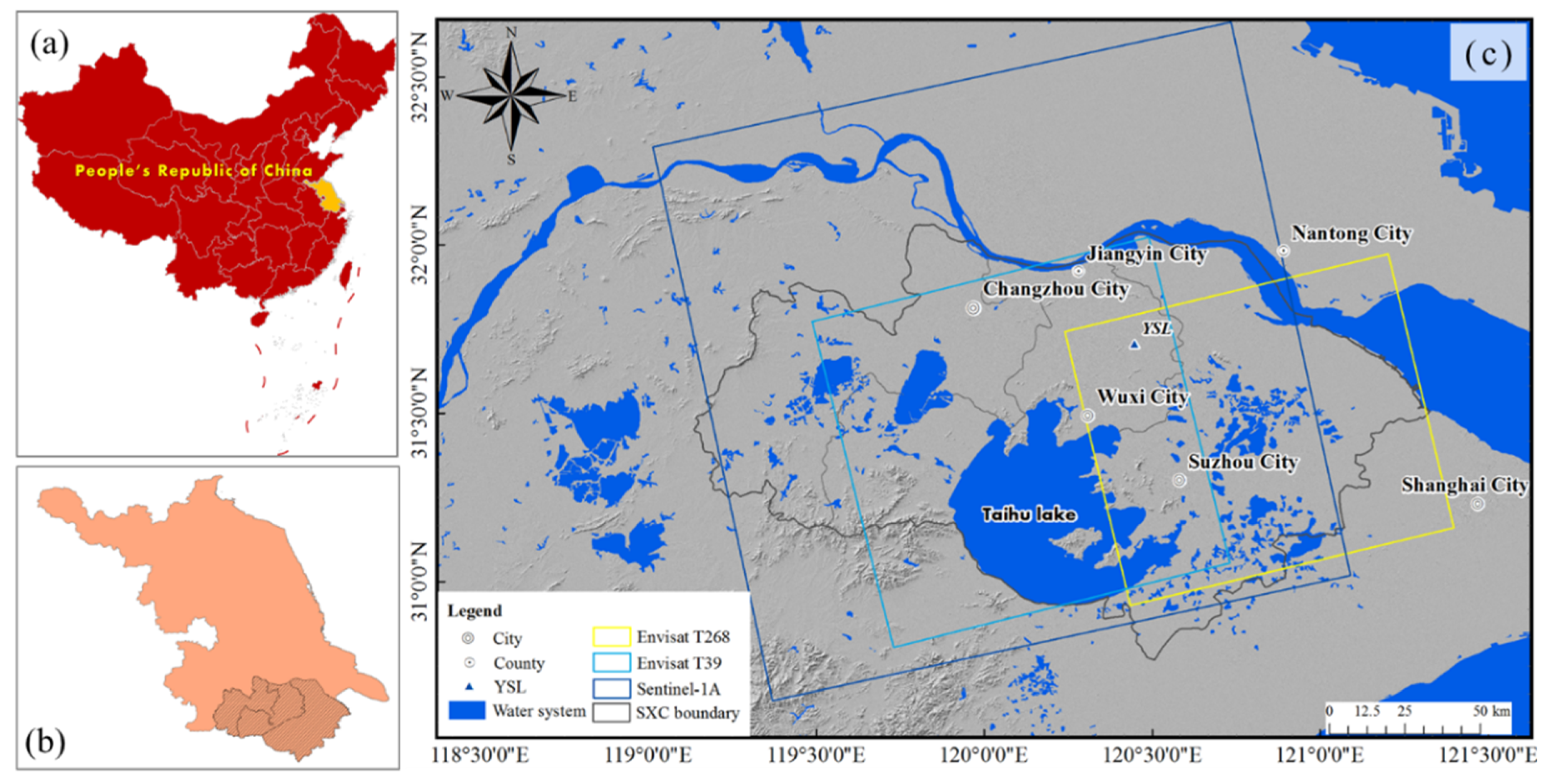
:1. Introduction
2. Research Status
3. Methods and Data Processing
3.1. Methods
3.2. InSAR Data Processing
3.3. Constitutive Relationship Model
4. Results and Analysis
4.1. Results from SAR Images
4.2. Land Subsidence Analysis
4.3. Ground Fissure Analysis
5. Deformation Modeling
5.1. Model Establishment
5.2. State of Equilibrium before Pumping
5.3. Pumping Simulation
6. Discussion
6.1. Deformation and Geological Factors
6.2. Ground Fissure Activity and Pumping
7. Conclusions
Author Contributions
Funding
Institutional Review Board Statement
Informed Consent Statement
Data Availability Statement
Acknowledgments
Conflicts of Interest
References
- Chaussard, E.; Wdowinski, S.; Cabral-Cano, E.; Amelung, F. Land subsidence in central Mexico detected by ALOS InSAR time-series. Remote Sens. Environ. 2014, 140, 94–106. [Google Scholar] [CrossRef]
- Hernandez-Marin, M.; Pacheco-Martinez, J.; Ramirez-Cortes, A.; Burbey, T.J.; Ortiz-Lozano, J.A.; Zermeno-de-Leon, M.E.; Guinzberg-Velmont, J.; Pinto-Aceves, G. Evaluation and analysis of surface deformation in west Chapala basin, central Mexico. Environ. Earth Sci. 2014, 72, 1491–1501. [Google Scholar] [CrossRef]
- Ojha, C.; Werth, S.; Shirzaei, M. Recovery of aquifer-systems in southwest US following 2012–2015 drought: Evidence from InSAR, GRACE and groundwater level data. J. Hydrol. 2020, 587, 16. [Google Scholar] [CrossRef]
- El Kamali, M.; Papoutsis, I.; Loupasakis, C.; Abuelgasim, A.; Omari, K.; Kontoes, C. Monitoring of land surface subsidence using persistent scatterer interferometry techniques and ground truth data in arid and semi-arid regions, the case of Remah, UAE. Sci. Total Environ. 2021, 776, 11. [Google Scholar] [CrossRef] [PubMed]
- Peng, J.B.; Xu, J.S.; Ma, R.Y.; Wang, F.Y. Characteristics and mechanism of the Longyao ground fissure on North China Plain, China. Eng. Geol. 2016, 214, 136–146. [Google Scholar] [CrossRef]
- Xu, J.; Meng, L.; An, H.; Wang, L. The bending mechanism of Anping ground fissure in the Hebei Plain, North China. Environ. Earth Sci. 2015, 74, 6859–6870. [Google Scholar] [CrossRef]
- Chen, B.B.; Gong, H.L.; Chen, Y.; Lei, K.C.; Zhou, C.F.; Si, Y.; Li, X.J.; Pan, Y.; Gao, M.L. Investigating land subsidence and its causes along Beijing high-speed railway using multi-platform InSAR and a maximum entropy model. Int. J. Appl. Earth Obs. Geoinf. 2021, 96, 15. [Google Scholar] [CrossRef]
- Li, M.-G.; Chen, J.-J.; Xu, Y.-S.; Tong, D.-G.; Cao, W.-W.; Shi, Y.-J. Effects of groundwater exploitation and recharge on land subsidence and infrastructure settlement patterns in Shanghai. Eng. Geol. 2021, 282, 105995. [Google Scholar] [CrossRef]
- Xiong, Z.M.; Wang, Y.W.; Chen, X.; Xiong, W.Y. Seismic behavior of underground station and surface building interaction system in earth fissure environment. Tunn. Undergr. Space Technol. 2021, 110, 14. [Google Scholar] [CrossRef]
- Cigna, F.; Tapete, D. Sentinel-1 big data processing with P-SBAS InSAR in the geohazards exploitation platform: An experiment on coastal land subsidence and landslides in Italy. Remote Sens. 2021, 13, 885. [Google Scholar] [CrossRef]
- Fabris, M. Monitoring the coastal changes of the Po River delta (Northern Italy) since 1911 using archival cartography, multi-temporal aerial photogrammetry and LiDAR data: Implications for coastline changes in 2100 AD. Remote Sens. 2021, 13, 529. [Google Scholar] [CrossRef]
- Wang, J. Theory and Application of Ground Fissures and Their Disasters; Shaanxi Science and Technology Press: Xi’an, China, 2000. [Google Scholar]
- Xu, J.; Peng, J.; An, H. Experimental study on Su-Xi-Chang earth fissures induced by repeated groundwater pumping and impounding. Geomat. Nat. Hazards Risk 2019, 10, 2051–2068. [Google Scholar] [CrossRef]
- Hu, J.P. A Study on the Land Subsidence Effect After Prohibiting Extraction of Ground Water in Suzhou-Wuxi-Changzhou Area. Ph.D. Thesis, Nanjing University, Nanjing, China, 2011. [Google Scholar]
- Budhu, M. Earth Fissure formation from the mechanics of groundwater pumping. Int. J. Geomech. 2011, 11, 1–11. [Google Scholar] [CrossRef]
- Jia, Z.J.; Qiao, J.W.; Peng, J.B.; Lu, Q.Z.; Xia, Y.Y.; Zang, M.D.; Wang, F.Y.; Zhao, J.Y. Formation of ground fissures with synsedimentary characteristics: A case study in the Linfen Basin, northern China. J. Asian Earth Sci. 2021, 214, 104790. [Google Scholar] [CrossRef]
- Nespoli, M.; Cenni, N.; Belardinelli, M.E.; Marcaccio, M. The interaction between displacements and water level changes due to natural and anthropogenic effects in the Po Plain (Italy): The different point of view of GNSS and piezometers. J. Hydrol. 2021, 596, 126112. [Google Scholar] [CrossRef]
- Tiwari, A.; Narayan, A.B.; Dwivedi, R.; Swadeshi, A.; Pasari, S.; Dikshit, O. Geodetic investigation of landslides and land subsidence: Case study of the Bhurkunda coal mines and the Sirobagarh landslide. Surv. Rev. 2020, 52, 134–149. [Google Scholar] [CrossRef]
- Zhang, Y.Q.; Gong, H.L.; Gu, Z.Q.; Wang, R.; Li, X.J.; Zhao, W.J. Characterization of land subsidence induced by groundwater withdrawals in the plain of Beijing city, China. Hydrogeol. J. 2014, 22, 397–409. [Google Scholar] [CrossRef]
- Damoah-Afari, P. Detecting Ground Settlement of Megacities Using InSAR Techniques. Ph.D. Thesis, Hong Kong Polytechnic University, Hong Kong, China, 2009. [Google Scholar]
- Wan, J.; Bin, L.I.; Tan, C.; Zhang, P.; Feng, C. Characteristics and mechanism of earth fissures in China: A case study of Fenhe River-Weihe River basin, Hebei plain and Suzhou-Wuxi-Changzhou plain. J. Geol. Rev. 2019, 65, 1383–1396. [Google Scholar] [CrossRef]
- Jian-Qiang, W.U.; Zhou, G.J.; Shu-Liang, W.U.; Wei, L.I.; Ming, W. Research on earth fissures in Guangming Village of Wuxi City. J. Geol. 2013, 37, 203–207. [Google Scholar]
- Shi, X.-Q.; Xue, Y.-Q.; Ye, S.-J.; Wu, J.-C.; Zhang, Y.; Yu, J. Characterization of land subsidence induced by groundwater withdrawals in Su-Xi-Chang area, China. Environ. Geol. 2007, 52, 27–40. [Google Scholar] [CrossRef]
- Bu, J.W.; Sun, Z.Y.; Ma, R.; Liu, Y.D.; Gong, X.L.; Pan, Z.; Wei, W.H. Shallow groundwater quality and its controlling factors in the Su-Xi-Chang region, Eastern China. Int. J. Environ. Res. Public Health 2008, 17, 1267. [Google Scholar] [CrossRef] [PubMed] [Green Version]
- Wang, G.-Y.; Zhu, J.-Q.; Zhang, D.; Wu, J.-Q.; Yu, J.; Gong, X.-L.; Gou, F.-G. Land subsidence and uplift related to groundwater extraction in Wuxi, China. Q. J. Eng. Geol. Hydrogeol. 2020, 53, 609–619. [Google Scholar] [CrossRef]
- Gu, K.; Shi, B.; Liu, C.; Jiang, H.; Li, T.; Jinghong, W. Investigation of land subsidence with the combination of distributed fiber optic sensing techniques and microstructure analysis of soils. Eng. Geol. 2018, 240, 34–47. [Google Scholar] [CrossRef]
- Zhao, W.-T.; Li, L. The mechanism of land subsidence and its prevention measures in Suzhou-Wuxi-Changzhou area. Chinese. J. Geol. Hazard Control 2009, 20, 88–93. [Google Scholar] [CrossRef]
- Gu, C. Experimental Study on the Development and Evolution of Ground Fissures Caused by Extraction of Groundwater in Suzhou-Wuxi-Changzhou Region. Master’s Thesis, China University of Mining and Technology, Xuzhou, China, 2017. [Google Scholar]
- Hooper, A.; Bekaert, D.; Spaans, K.; Arikan, M. Recent advances in SAR interferometry time series analysis for measuring crustal deformation. Tectonophysics 2012, 514–517, 1–13. [Google Scholar] [CrossRef]
- Wang, G.-Y.; You, G.; Zhu, J.-Q.; Yu, J.; Gong, X.-L.; Wu, J.-Q. Investigations of Changjing earth fissures, Jiangyin, Jiangsu, China. Environ. Earth Sci. 2016, 75, 502. [Google Scholar] [CrossRef]
- Wu, Z.; Yu, Q.; Zhang, Y. Forming process of earth fissure hazard in the Suzhou-Wuxi-Changzhou area. Hydrogeol. Eng. Geol. 2003, 30, 67–72. [Google Scholar] [CrossRef]
- Yang, Y. The Influence of the Land Subsidence Around Su-Xi-Chang Area to the Bejing-Shanghai High-Speed Railway. Master’s Thesis, Southwest Jiaotong University, Nanjing, China, 2012. [Google Scholar]
- Yuan, Y.; Zhang, T. Prediction of ground fissures risk in Suxichang area based on principal component analysis and support vector machine. J. Catastrophol. 2019, 34, 57–63. [Google Scholar] [CrossRef]
- Chen, Y.; Zhao, W.; Huang, Y.; Jia, P. Investigation of land subsidence based on the column element settlement model in a soft-soil area. Geofluids 2019, 2019, 9530135. [Google Scholar] [CrossRef]
- Liu, Y.; Zhang, D.; Wang, G.Y.; Liu, C.; Zhang, Y. Discrete element method-based prediction of areas prone to buried hill-controlled earth fissures. J. Zhejiang Univ. Sci. A 2019, 20, 794–803. [Google Scholar] [CrossRef]
- Gabriel, A.K.; Goldstein, R.M.; Zebker, H.A. Mapping small elevation changes over large areas: Differential radar interferometry. J. Geophys. Res. 1989, 94, 9183–9191. [Google Scholar] [CrossRef]
- Zebker, H.A.; Rosen, P.A.; Goldstein, R.M.; Gabriel, A.; Werner, C.L. On the derivation of coseismic displacement fields using differential radar interferometry: The Landers earthquake. J. Geophys. Res. 1994, 99, 19617–19634. [Google Scholar] [CrossRef]
- Rosen, P.A.; Henley, S.; Peltzer, G.; Simons, M. Updated repeat orbit interferometry package released. Eos Transact. Am. Geophys. Union 2013, 85, 47. [Google Scholar] [CrossRef]
- Kampes, B.M. Radar Interferometry: Persistent Scatterer Technique; Springer: Dordrecht, The Netherlands, 2006. [Google Scholar]
- Hooper, A.; Bekaert, D.; Spaans, K. StaMPS/MTI Manual Version 3.3 b1; University of Leeds: Leeds, UK, 2013. [Google Scholar]
- Likoka, A.S. Atmospheric effects estimation on SAR images using a pure statistical method. In Computational Imaging II, Proc. SPIE 10222; SPIE: Bellingham, WA, USA, 2017. [Google Scholar] [CrossRef]
- Budhu, M. Mechanics of earth fissures using the Mohr–Coulomb failure criterion. Environ. Eng. Geosci. 2008, 14, 281–295. [Google Scholar] [CrossRef]
- Martinez-Noguez, I.; Hinkelmann, R. Land subsidence caused by a single water extraction well and rapid water infiltration. In Prevention and Mitigation of Natural and Anthropogenic Hazards due to Land Subsidence; Daito, K., Galloway, D., Eds.; Copernicus Gesellschaft Mbh: Gottingen, Germany, 2015; pp. 33–38. [Google Scholar] [CrossRef] [Green Version]
- Yang, C.; Zhang, F.; Liu, R.; Hou, J.; Zhao, C. Ground deformation and fissure activity of the Yuncheng Basin (China) revealed by multiband time series InSAR. Adv. Space Res. 2020, 66, 490–504. [Google Scholar] [CrossRef]
- Qu, F.; Zhang, Q.; Lu, Z.; Zhao, C.; Yang, C.; Zhang, J. Land subsidence and ground fissures in Xi’an, China 2005–2012 revealed by multi-band InSAR time-series analysis. Remote Sens. Environ. 2014, 155, 366–376. [Google Scholar] [CrossRef]
- Bechor, N.; Zebker, H.A. Measuring two-dimensional movements using a single InSAR pair. Geophys. Res. Lett. 2006, 33, 275–303. [Google Scholar] [CrossRef] [Green Version]
- Samsonov, S.; Tiampo, K. Analytical optimization of a DInSAR and GPS dataset for derivation of three-dimensional surface motion. IEEE Geosci. Remote Sens. Lett. 2006, 3, 107–111. [Google Scholar] [CrossRef]
- Wright, T.J.; Parsons, B.E.; Lu, Z. Toward mapping surface deformation in three dimensions using InSAR. Geophys. Res. Lett. 2004, 31, L01607. [Google Scholar] [CrossRef] [Green Version]
- Wang, Y.; Shujun, Y.E.; Jun, Y.U.; Gong, X.; Hydrosciences, D.O. Features and mechanisms of earth fissures induced groundwater withdrawal in China. Geol. J. China Univ. 2016, 22, 741. [Google Scholar] [CrossRef]
- Li, C.-Q.; Liang, Q.G.; Xu-Yang, W.U.; Wang, L.L.; Shan-Chang, X.U. Study on the test of tensile strength of remolded loess. China Earthq. Eng. J. 2014, 233–238, 248. [Google Scholar] [CrossRef]
- Yao, Y.; Zhang, B.; Zhu, J. Behaviors, constitutive models and numerical simulation of soils. Tumu Gongcheng Xuebao/China Civil Eng. J. 2012, 45, 127–150. [Google Scholar] [CrossRef]
- Zhang, Y. Study on The Engineering Mechanic Properties of Loess-Paleosol. Master’s Thesis, Xi’an University of Architecture and Technology, Xi’an, China, 2011. [Google Scholar]


| Sensor | Envisat T268 | Envisat T39 | Sentinel 1A (T69) |
|---|---|---|---|
| Band | C | C | C |
| Orbit direction | ascending | ascending | ascending |
| Heading (°) | −13.2 | −13.2 | −12.7 |
| Incidence angle (°) | 23.2 | 23.2 | 39.3 |
| Polarization | VV | VV | VV |
| Number of interferograms | 21 | 23 | 42 |
| Master image | 14 February 2009 | 29 January 2009 | 22 February 2020 |
| Time span | March 2008–February 2009 | November 2007–April 2010 | January 2019–June 2021 |
| Parameter | Value | |||
|---|---|---|---|---|
| Loess | Clay | Sand | Bedrock | |
| Cohesion, c (kPa) | 35 | 800 | 39 | 4620 |
| Dilation angle, (°) | 14 | 9.5 | 12.5 | 22.5 |
| Internal friction angle, (°) | 28 | 19 | 25 | 45 |
| Tensile strength, T (kPa) | 0 | 0 | 400 | 4500 |
| Permeability coefficient, k (m2/Pa/s) | 5.1 × 10⁻¹⁰ | 0.3 × 10⁻⁷ | 2.04 × 10⁻⁹ | 1.02 × 10⁻¹⁵ |
| Elastic modulus, E (MPa) | 40 | 150 | 120 | 5400 |
| Porosity, n | 0.48 | 0.38 | 0.4 | 0.1 |
| Poisson’s ratio, υ | 0.35 | 0.3 | 0.23 | 0.29 |
Publisher’s Note: MDPI stays neutral with regard to jurisdictional claims in published maps and institutional affiliations. |
© 2022 by the authors. Licensee MDPI, Basel, Switzerland. This article is an open access article distributed under the terms and conditions of the Creative Commons Attribution (CC BY) license (https://creativecommons.org/licenses/by/4.0/).
Share and Cite
Yang, C.; Lv, S.; Hou, Z.; Zhang, Q.; Li, T.; Zhao, C. Monitoring of Land Subsidence and Ground Fissure Activity within the Su-Xi-Chang Area Based on Time-Series InSAR. Remote Sens. 2022, 14, 903. https://doi.org/10.3390/rs14040903
Yang C, Lv S, Hou Z, Zhang Q, Li T, Zhao C. Monitoring of Land Subsidence and Ground Fissure Activity within the Su-Xi-Chang Area Based on Time-Series InSAR. Remote Sensing. 2022; 14(4):903. https://doi.org/10.3390/rs14040903
Chicago/Turabian StyleYang, Chengsheng, Sen Lv, Zuhang Hou, Qin Zhang, Tao Li, and Chaoying Zhao. 2022. "Monitoring of Land Subsidence and Ground Fissure Activity within the Su-Xi-Chang Area Based on Time-Series InSAR" Remote Sensing 14, no. 4: 903. https://doi.org/10.3390/rs14040903